

Introduction
The War of the Pacific (1879–1883) between Chile, Peru, and Bolivia marked a turning point in the political and socio-economic development of the Atacama Desert. Formerly part of Bolivia, the area came under the control and jurisdiction of Chile. This shift in sovereignty substantially altered the trinational geopolitics, forcing the local Bolivian population to flee.
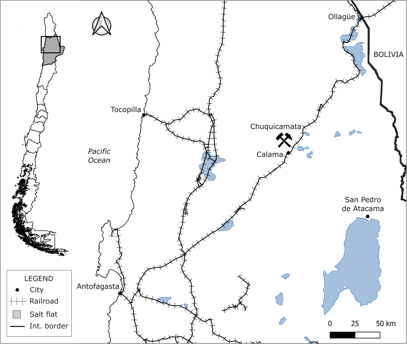
Chuquicamata is a copper mine in the Antofagasta Region at the heart of the Atacama Desert (Figure 1), owned by the American Guggenheim family between 1912 and 1925. The Guggenheim brothers chose the city of Antofagasta's port to export the mine's production. The mine and the port, separated by 230 kilometers and connected by a railroad, were fundamental for the intense economic process that marked the mining identity of the Atacama Desert during the twentieth century. Both poles of economic development overgrew after 1915, giving rise to an upward commercial dynamic.
Location Map of Chuquicamata in the Antofagasta Region, Northern Chile. Source: Authors’ elaboration.
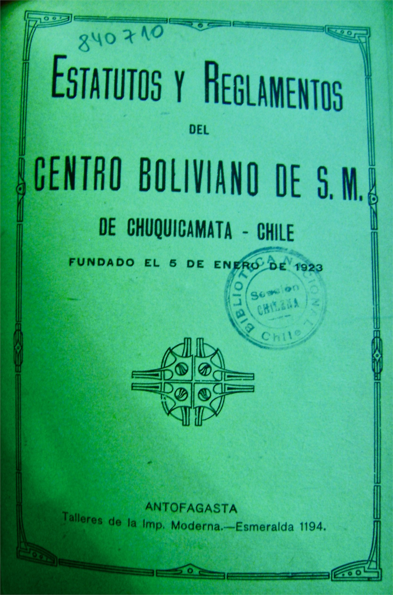
It was also in Antofagasta that, in 1923, a group of Bolivians went to the renowned Imprenta Moderna, a local publisher and distributor of magazines and books. They aimed to print a small book with an intriguing title: Statutes and Regulations of the Bolivian Centre of Mutual Aid of Chuquicamata – Chile. Founded on January 5, 1923 (Figure 2), this book speaks to the significant presence of Bolivian migrants in a former Bolivian territory. Although the Antofagasta region became a Chilean administrative territory, its economic policies were controlled by American capitals. The book demonstrates how Bolivian migrants established reciprocity and mutual aid for each other in an adverse and conflictive socio-labor context. In Chuquicamata, the primarily indigenous and subaltern Bolivian migrants lacked social or economic mobility, were discriminated against by Americans and Chileans, and were given the most precarious and physically demanding jobs.
Statutes and Regulations of the Bolivian Centre of S.M., Published in Antofagasta in 1923.
Through analyzing migratory documents, we argue that Bolivian migrants constituted a fundamental labor force for maintaining and developing the mining industry in northern Chile. In particular, these documents allow us to understand the labor relations established in Chuquicamata during the Guggenheim family ownership. However, Bolivian migrants had to endure labor disputes and discrimination. Thus, labor conditions determined migration flows from Bolivia to northern Chile during the Guggenheim era (1912–1925). Because of the new postwar mining, social context, Bolivian migrants who came to Chuquicamata as subaltern workers in conditions of labor precariousness were labeled as foreigners and “Indians.” This historical process is described through what we define as ethnic-labor subsidiarity, a product of ethnic discrimination expressed in the physical overload, low wages, and overall costs of mining work.
This article demonstrates that Bolivian migration was connected to and activated by expanding US mining capitalism in a region alienated from Bolivia. At a global level, such expansions are inscribed into what Jeffrey D. Sachs called the “rise of U.S. hegemony,” in parallel with the decline of the British empire.Footnote 1 Both processes impacted the northern Chilean desert; the case we describe is part of this global history. We define ethnic-labor subsidiarity as the usufruct of an indigenous labor force that pays the costs of local mining development. As former inhabitants of the Atacama Desert's particular geography, Bolivian migrants were expected to adapt to work in adverse environmental conditions, including low oxygen levels, high daytime solar radiation, low nighttime temperatures, and aridity. When we speak of ethnic-labor subsidiarity, we refer to an ideological production proper to a capitalist process with its respective colonial relations accentuated by the results of the war. Thus, imaginaries and signifiers of inferiority were mobilized by Chileans and Americans toward Bolivian alterity, in this case, toward “second-class” worker migrants from a defeated country.
These workers’ essential role in mining development depended on intense labor precariousness, evidencing, as in all colonial history, “a material matrix, a symbolic institution and a psychic component of politics and imperial conscience.”Footnote 2 With their energies, forces, and bodies, Bolivian migrants subsidized the mining expansion of refined copper. Achille Mbembe refers to bio-economy as the racialization and classification of working populations “as species, as series (…) within a general calculus,”Footnote 3 the fruits of a process of “ethnicization of the social relations of production,”Footnote 4 which defined devices and semantics for the classification of otherness and the application of a racialized working identity.Footnote 5 Chilean workers reproduced these discourses and practices of exclusion under the cover of a political and cultural campaign of the state called “Chileanization.”
Referring to the mining industry's labor demands, the Bolivian newspaper La Verdad commented in August 1919 that American-sponsored Bolivian recruiters were carrying out a “criminal attempt.” They were “traders of the unwary.” The newspaper added that recruiters sought to hire those “who know nothing about the organization, who (…) accept the first thing they are offered….”Footnote 6 Despite several critical international studies on one of the largest copper mines in the world,Footnote 7 Bolivian migration in Chuquicamata during the postwar period has not been studied quantitatively or qualitatively, nor has it been considered from the perspective of racism and working life. This article addresses Bolivian migration through the concept of ethnic-labor subsidiarity, allowing, for the first time, to detail and make visible the characteristics of this migrant group essential in the mining development of Chuquicamata between 1912 and 1925.
Materials and Methods
We characterize the migration of Bolivians to work in the Chuquicamata copper mine with primary sources produced when the mine was under the control of the Guggenheim family. We base our analysis on migration documents and newspapers found in the Archivo de Extranjería del Registro Civil e Identificaciones de Antofagasta (AERCI [Foreigners of the Civil Registry and Identifications of Antofagasta]), an archival collection kept at the Archivo Histórico de la Universidad Católica del Norte de Antofagasta (AHUCN [Historical Archives of the Universidad Católica del Norte of Antofagasta]). These documents allowed us to build a database containing 3,794 cases of Bolivian migrants who entered Chile between 1879 and 1946. We identified 353 Bolivians who migrated directly to Chuquicamata between 1881 and 1942, the highest concentration occurring during the Guggenheim ownership period (n = 239). We present migration data regarding the years of entry of Bolivian men and women at Chuquicamata and their places of origin, trade and profession, marital status, age, and literacy. Analyzing the migratory files allows us to discuss the productive and social contexts of the mine between 1912 and 1925 and situate them in global working-class history.
The 3,794 Bolivian migrants registered in Chile lived in eighty-seven places in the Antofagasta desert. These places, which range from the coast to the highlands, are classified into seven types: 1) cities, 2) saltpeter offices, 3) silver mines, 4) copper mines, 5) pre-cordilleran towns, 6) sulphur and border towns, and 7) railway stations. Among the ten places with the highest number of Bolivian migrants, the city of Antofagasta concentrates the majority (32.4 percent). Chuquicamata follows as the second most frequent destination (9.3 percent), followed by Calama (7.3 percent), the María saltpeter camp (5.3 percent), Collahuasi (5.0 percent), Cebollar (4.3 percent), Ollagüe (2.8 percent), the Aconcagua saltpeter camp (2.6 percent), and the Luisa saltpeter camp (2.5 percent). In this article, we focus on Chuquicamata. This unique mining project developed and modified a territory alienated from Bolivia and stood as the world's largest copper mine for most of the twentieth century. Converted into foreigners, Bolivian workers became the ones who transformed and gave life to a mining project planned in the United States.Footnote 8
Chuquicamata Under the Guggenheim Ownership
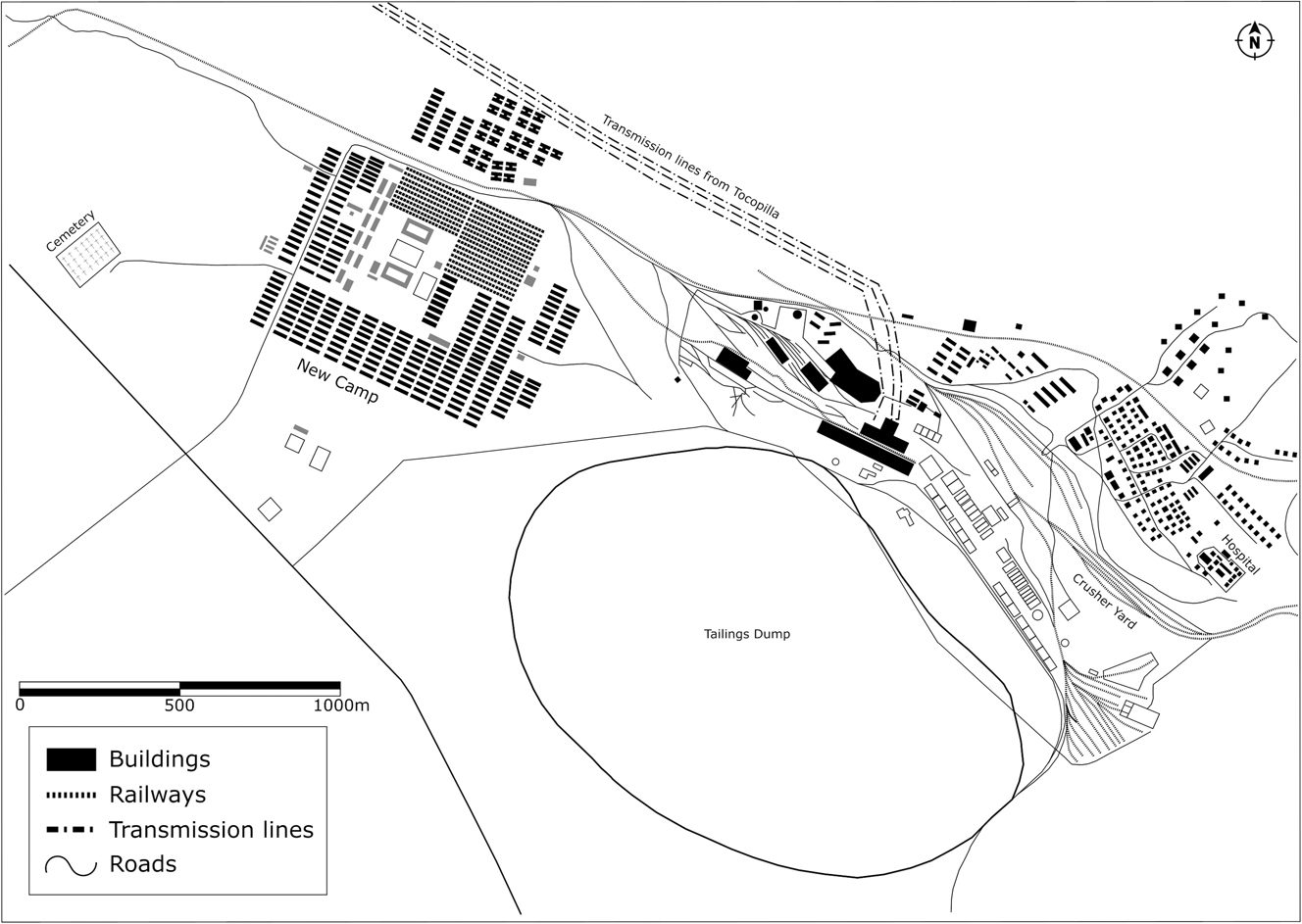
During the first five years of the twentieth century, Chuquicamata was the primary Chilean copper mine. It produced “two thousand tons of 17 percent of ore” monthly. In the 1910s, Chuquicamata underwent a substantial transformation with the arrival of the Guggenheims, an influential American family. Various factors stimulated their economic interest in the Chuquicamata mine. First, mining developers had access to detailed geological information and knew the mine's extraction potential. Second, the global rise of copper prices since 1896 was a significant stimulus for forming numerous mining societies battling to obtain mining concessions. The increase in copper prices broke the downward trend that had begun with Chile's economic crisis in 1873.Footnote 9 A third relevant factor was the railroad extension connecting Antofagasta with the Bolivian highlands, which in 1886 reached Calama, a city located only 19 km south of Chuquicamata. Macchiavello pointed out, “Without railroads, Chuquicamata and El Teniente would not have been even the shadow of what they are.”Footnote 10 Means of transport and industrial facilities thus significantly transformed Chuquicamata during the Guggenheim period, converting it into an industrial complex that altered the local landscape and the national economyFootnote 11 (Figure 3). Inaugurated by the Huanchaca Company of Bolivia, this railroad was part of the mechanical expansion articulating Antofagasta with Bolivian highlands.Footnote 12 A fourth factor was the new Chilean Mining Code of 1888, which modified the protection regime of mining property and led to a new form of maintenance through the payment of annual patents.Footnote 13 The Mining Code liberalized mining developments and produced “the disappearance of one of the most traditional principles of the mining regime: effective work, as a way of justifying the granting of the mining concession.”Footnote 14
Plan of the New Camp built in 1916 and the copper mine facilities. Source: Archivo Gobernación Provincial de Tocopilla, Chile. Authors’ elaboration.
The configuration of two important societies fostered the Guggenheim family's mining interest in Chuquicamata: the Compañía de Cobres de Antofagasta, in 1899, a partnership between Norman Walker and the Society of Duncan Fox and the Sociedad Explotadora de Chuquicamata, constituted in 1903. The latter society signed a contract to lease mining properties with Albert Burrage,Footnote 15 a Boston engineer, banker, friend, and advisor to the Guggenheim brothers.Footnote 16 On January 11, 1912, the Chile Exploration CompanyFootnote 17 was established at the 15th Exchange Place in Hudson County, New Jersey.Footnote 18 The board of directors was composed of Daniel Guggenheim (president), Albert Burrage (vice president), Murry Guggenheim (vice president), and Harry Guggenheim (vice president). The company simultaneously began buying all the mining properties in the Atacama area. In the port of Tocopilla, located 140 kilometers west of Chuquicamata, the Guggenheim brothers acquired properties to establish a thermoelectric plant to power up the mining project,Footnote 19 leading to the production of 3,160 fine metric tons of copper during the first year.Footnote 20 The financing of this massive industrial complex was possible thanks to the US$15 million issued by the Chile Copper Company of Delaware.Footnote 21 Chuquicamata became a relevant mining center that operated with large-scale production, “an emporium of wealth, superior to Riotinto in Spain, Valenciana in Mexico, and Cerro de Pasco in Peru, to Kermecott in Alaska and Inspiration in Arizona.”Footnote 22
The American Mohave County Miner reported in May 1914 that, to accommodate the workers, “the company is building a city which will contain among other buildings a soldiers' barracks, two public schools, a court house and telegraph and postal building, a theatre, a hospital, a public quarantine, a Protestant church and Catholic church, a music hall for workmen, and a public library.”Footnote 23 The newspaper emphasized the segregation of this new company town: “The city will consist of two sections, one for foreigners and one for natives. It will probably be the best industrial city in South America.”Footnote 24 The American Norwich Bulletin mentioned, in November 1915, that: “There are now about 350 Americans and Europeans and more than 3,000 natives housed on the property (…) The surveillance is carried out by a company of mounted police carabineros from Chile, who have accommodation in the camp.”Footnote 25
The new city built by the Americans was inspired by what happened in Mexico in 1910, when the family saw an entire economic empire crumble because of the revolution. By 1910, the Guggenheims had invested around a quarter of their fortune—a capital estimated at $50 million dollars—mainly in the Monterrey area, where they set up a smelter, later extending their investments to other regions such as Aguascalientes. Under the government of Porfirio Díaz, the Guggenheim group enjoyed multiple privileges, guarantees, and perks. However, the Mexican Revolution changed the country's political and economic context,Footnote 26 convincing the American family that creating cities was better than annexing already consolidated ones, an idea they applied at Chuquicamata.
Chuquicamata's copper mining technology, housing, capital, and labor organization were complex. Informal work patterns were replaced by a transition to full-time specialization and entirely new types of production relations. Josh Dewind has highlighted the importance of the relationship between productive systems, modes of production, and the organization of workers in trade unions.Footnote 27 He demonstrated that the formation of permanent unions at the large mining center of Cerro de Pasco, in Peru, reflected a change in the workforce that began with the introduction of new production methods: first with the incorporation of sophisticated and complicated metallurgical plants and then with the use of new mechanized extractive technology in the mines. This situation forced this company to replace temporary miner-peasants with skilled and permanent workers. Dewind shows how the new workforce had more interest in improving production relations because of its relative permanence in the mines than temporarily hired peasant miners. In time, the transformation of the labor system brought about conflicts and laid the foundation for organized forms of resistance toward the exploitation of mining workers.Footnote 28 Our study highlights the social tensions between local communities and foreign capital, and globally, between the Global North's accumulation needs and the exploitation of the Global South's labor force. Ethnographic studies conducted in the Andes have analyzed similar processes of mining exploitation.Footnote 29 In Peru, for example, Elizabeth Dore demonstrated the critical role of the relationship between production relations and forms of property ownership, “the primary factors that condition the pace of technical change, the possibilities of increasing productivity, and the expansion of production.”Footnote 30 For Dore, “the nature of the labor force and how it develops, the form of ownership of resources and machinery, the characteristics of the labor process, and the impact of struggles between workers and owners, taken together, condition how production is organized. Therefore, within this framework, the characteristics of the social relations of production are the primary determinants of the process of economic development.”Footnote 31
Chuquicamata, in similar ways to Cerro de Pasco, was thus characterized by the increase in the scale of production due to mechanization. Industrial activities needed to incorporate a specialized and permanent labor force that had to endure harsh working conditions. Archival records of Bolivian workers involved in the Chuquicamata mining show the social context of how a multi-ethnic society took shape, characterized by an asymmetrical and disdainful relationship between indigenous migrants and local workers.
Bolivian Migration in Chuquicamata
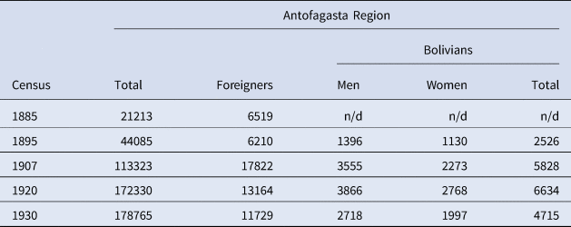
The census conducted in the newly annexed region of Antofagasta indicated a fluctuating number of the Bolivian population between 1885 and 1930 (Table 1).Footnote 32 A decline was observed in 1930 caused by the dismantling of the Shanks process in saltpeter mines in 1919, and the subsequent international economic crisis in 1929. These factors forced the closure of many mining centers, causing significant migration flows due to unemployment.Footnote 33 The critical census numbers in Table 1 show the substantial presence of Bolivian migrants in a newly annexed postwar region. The memory of the territory, family, and social networks and the installation of extractive mining projects formed a cross-border space that articulated important migratory movements. In Chuquicamata, migration was intense during the American ownership. Although the Chilean census stated it was a “village of little importance”Footnote 34 in 1907, when only 317 people lived in Chuquicamata,Footnote 35 by 1920, there were 9,715 inhabitants, of which 3,979 were male workers.Footnote 36 In 1920, the Chilean newspaper El Mercurio reported more figures: “In Chuquicamata, there are 14,000 inhabitants, of which 5,000 are in the offices, and 70 percent are Chileans, 15 percent Bolivians and the rest of various nationalities.”Footnote 37
The population of the Antofagasta region.
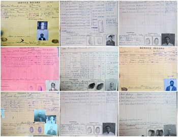
Bolivian workers migrated to Chuquicamata to fill any positions, regardless of the skill required. Among those microhistories available in the archives, we can mention, for example, the one of Andrés Puma Cóndores. Born on May 19, 1894, he arrived on January 1, 1920, to work as a bricklayer but became a porter in the pulpería (company store) in 1923, a job he held until the 1950s. Tiburcio Zelda Beizaga, born in 1903, worked as a key holder in 1926 and a foreman in 1934. Montiu Canedo Arroyo, born in Cochabamba in 1928, worked as a lathe operator and mechanic. In 1932, his service record indicates that he “received a ticket” to return to Bolivia. Gerardo Panoso, born in Cochabamba in 1896, was reported as a mechanic. In 1924, the files indicated that he was working with a compressor in Chuquicamata. Hilarión Pimienta, born in 1906, worked as a brakeman. Later, he worked in several positions: the contracts area, mining samples, and the mine. These small cases illustrate the panoply of trades occupied by Bolivian migrants in Chuquicamata. They were foreigners, immigrants in a familiar land (Figure 4).
Service Records of Bolivian Workers in Chuquicamata. Source: Personal archive of Víctor Tapia Araya. Used with permission.

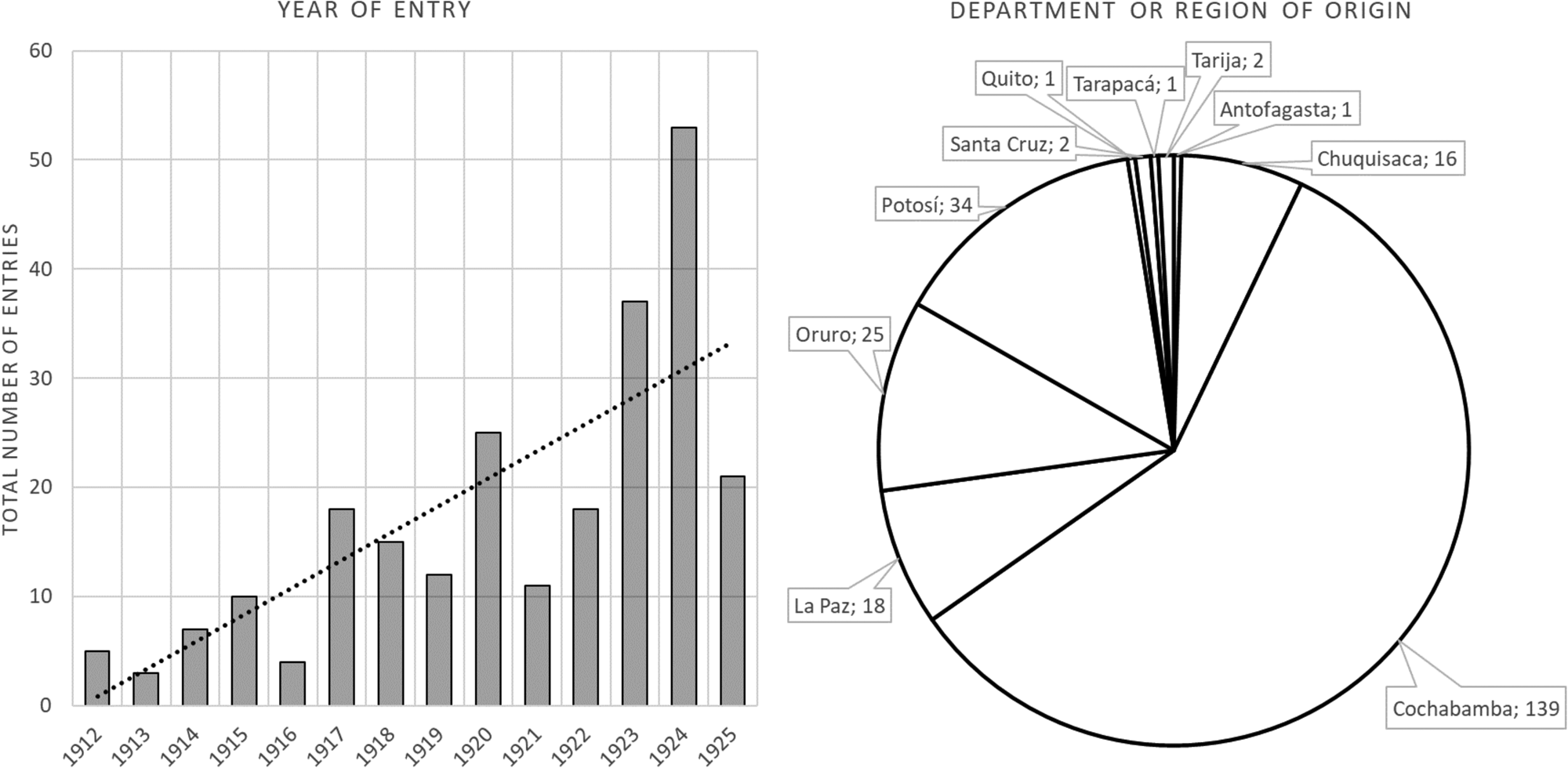
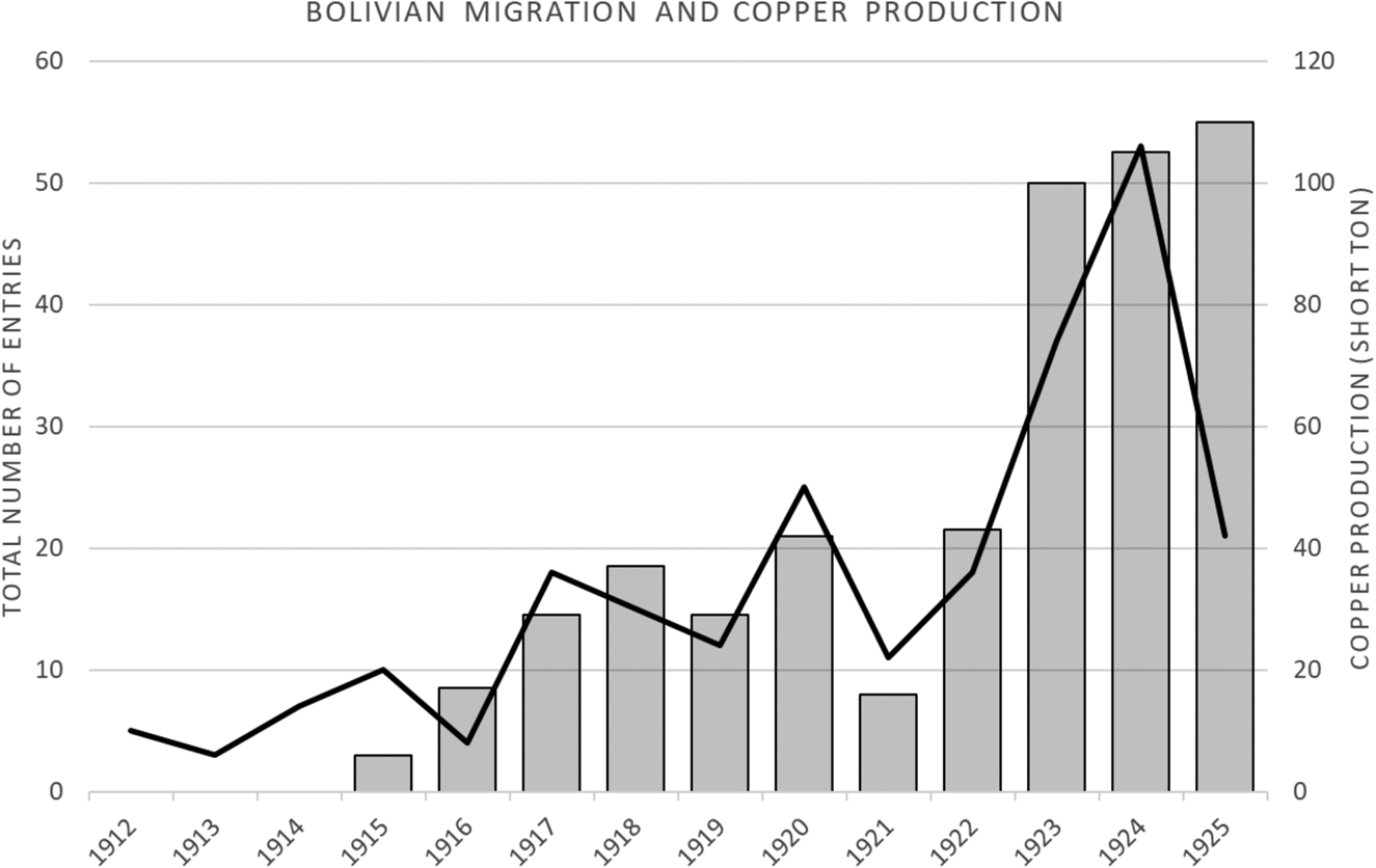
Through migratory documents and archives, it is possible to characterize Bolivian migration in Chuquicamata between 1915 and 1925, assessing relevant information concerning the places of origin, gender, marital status, age, and trade or professions of Bolivian newcomers. The AHUCN archival data shows the total entry of men and women of Bolivian origin to Chuquicamata with an upward trend until 1915, with a substantial increase in 1917, 1920, 1923, and 1924. Then, in 1925, the entries decreased abruptly (Figure 5). These data coincide with the period after the mine sale by the Guggenheims to the Anaconda Copper company in 1923, modifying the capital flows and the migratory movement of foreign workers. An interesting correlation between the migratory waves of Bolivian workers with mining production is worth noting, at least until 1924, when the American family completed the first years of industrialization (Figure 6). Between 1915 and 1925, Chuquicamata produced 48.5 tons per year on average, and its steady growth is undoubtedly due to migrant labor, of which Bolivians formed a critical community.
Number of Entries with Tendency Line (left) and Department or Region of Origin (right) of Bolivian Migrants Between 1912 and 1925. Source: Authors’ elaboration from AHUCN files.
Bolivian Migration (line) and Copper Production in Chuquicamata (columns) Between 1912 and 1925. Source: Authors’ elaboration from AHUCN files and The Anaconda Company, Producer of Copper in the Atacama Desert of Northern Chile (New York, 1970), 33.
Places of Origin
Regarding the origin of Bolivian migrants between 1912 and 1925, Cochabamba was the department where most of the migrants came from (58.2 percent of the total entries) (Figure 5). This situation differed from the middle of the twentieth century when migratory flows were dependent on family networks and economies, established mainly between adjacent geographical areas in the highlands of Bolivia and Chile.Footnote 38 The Department of Cochabamba is a critical place of origin. This region had a population of approximately 40,000 inhabitants in the first five years of the 1920s.Footnote 39 After the War of the Pacific, Cochabamba suffered a decline in its role as an agribusiness supplier (grains, fruits, flour, vegetables, leather, woolen garments) for various mining centers, including the mining camps of Pulacayo, Huanchaca, and several saltpeter mining centers in northern Chile.Footnote 40 During the war, Bolivian trade with Chile was blocked. Due to the 1885 Complementary Protocol, custom exemptions enabled a variety of merchandise and goods to enter Bolivia from Chile at meager prices,Footnote 41 affecting an entire regional economy.Footnote 42 The construction of the railroad connecting Antofagasta to Bolivia (FCAB) in 1890 accelerated social and economic consequences, densifying the urban economic participation of cities such as Uyuni and Oruro. These cities acted as dynamic nodes of internal migration and showed significant demographic increases following the construction of the railroad.
The economic crisis in the Department of Cochabamba led several landowners to fragment their agricultural properties, resulting in the emergence of small landowners known as parceleros. Between 1908 and 1916, official documents counted 28,550 properties, practically tripling the number of properties registered at the end of the nineteenth century.Footnote 43 In addition to the crisis, droughts had significant impacts on cereal production.Footnote 44 In these circumstances, the emigration of Bolivians toward tin, silver, sulfur, and copper mining centers was inevitable, and the FCAB railroad served as transportation for the entry of many Bolivians to these centers.
By the 1920s, the Cochabamba area was revitalized by the alcohol industry's nationalization, requiring greater exploitation of the Cochabamba Valley's sugar cane and cornfields, increasing the production of the distilleries and the growth of local workforce demand.Footnote 45 Under the government of President José Manuel Justiniano Gutiérrez Guerra, the nationalization decree stated in its first article: “The importation of foreign spirits and liqueurs shall be prohibited.”Footnote 46 While in 1917, 1 percent of maize production went to the alcohol industry, between 1923 and 1925, this increased to 37 percent.Footnote 47 However, the economy of Cochabamba would suffer the oscillations of price speculation, the impacts of smuggling, the rise in freight rates, and international competitiveness. As pointed out by Hector Sheriff, the depression of the 1920s coincided with the end of the liberal governments, which implied “the return of political instability and the weakening of the economy.”Footnote 48 Bolivian exports in 1921 decreased by 44 percent compared to those in 1920. The regional context of the economic crisis and the constant fluctuation of prices of agribusiness goods in the regional market were thus critical factors in the migratory flows of Bolivian workers to Chuquicamata. Working in copper mining in northern Chile became a life project for many Bolivians suffering from the ravages of these economic crises.
Gender, Age, and Marital Status
Bolivian migrants in Chuquicamata were primarily men (91.2 percent of the total entries), half single (Figure 7). As in other Andean mining contexts,Footnote 49 this predominance of single men suggests a sporadic presence, as they planned to work in the mines for short periods, save money, and then return to their places of origin. In the case of women, the percentage is lower; 16.1 percent of them were single, while married women represented 77.4 percent and widowed women represented 6.5. The above suggests that female migration was mainly associated with their marital relationship.
Year of Entry by Gender and Marital Status of Bolivian Migrants. Source: Authors’ elaboration from AHUCN files.
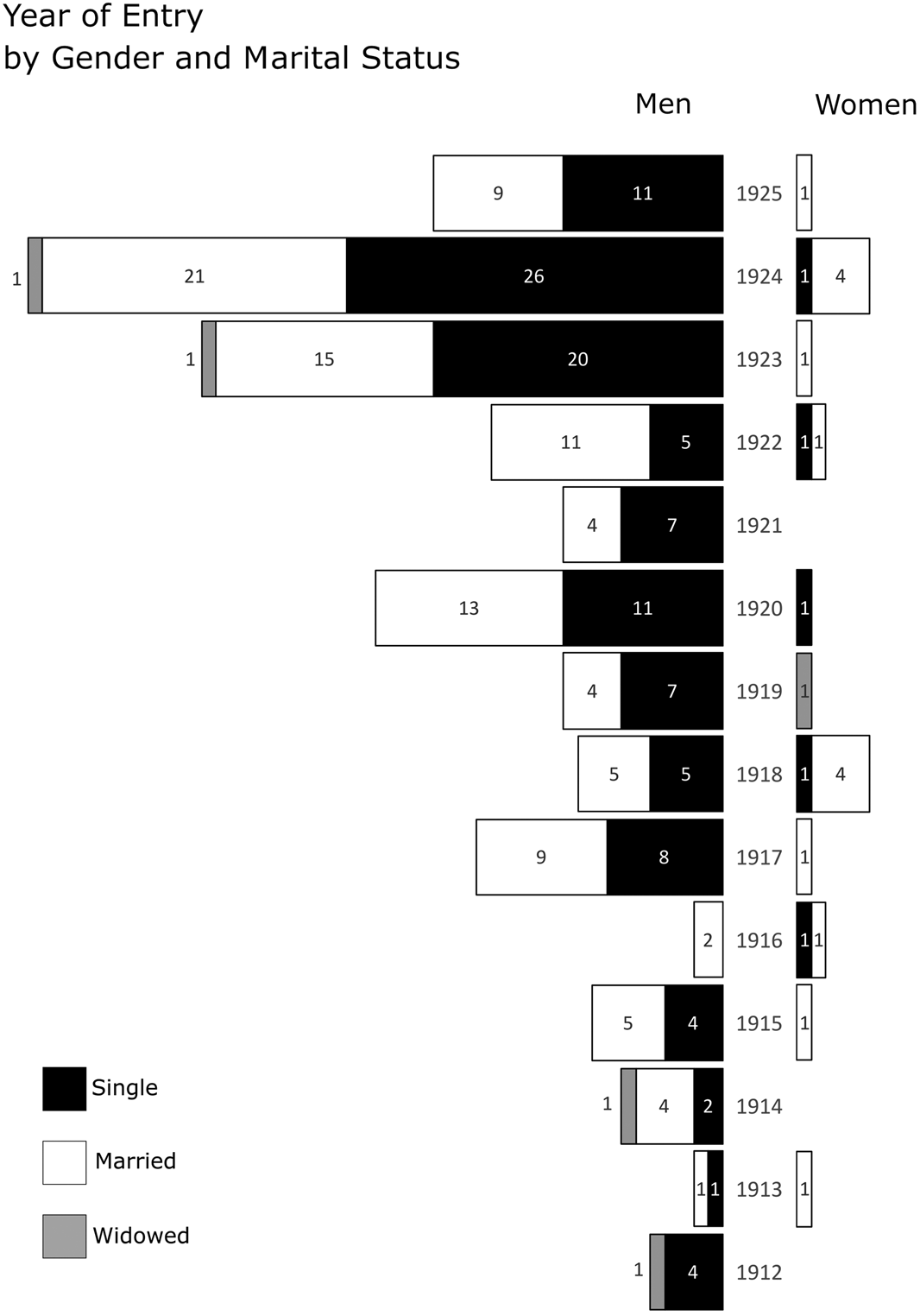
The year of entry of Bolivian migrants concentrates between 1917 and 1924. The mean year of entry for single and married men is 1921, while for single and married women, the mean year is 1920. Widowed men and women arrived a few years earlier, with a mean year of entry of 1918 for men and 1919 for women migrants. Bolivians arriving at Chuquicamata were primarily young (Figure 8). In the case of men, 55.5 percent were aged between 20 and 30 years old, and 12.8 percent were under 18 years old.
Boxplot of Age by Gender and Marital Status of Bolivian Migrants. Source: Authors’ elaboration from AHUCN files.
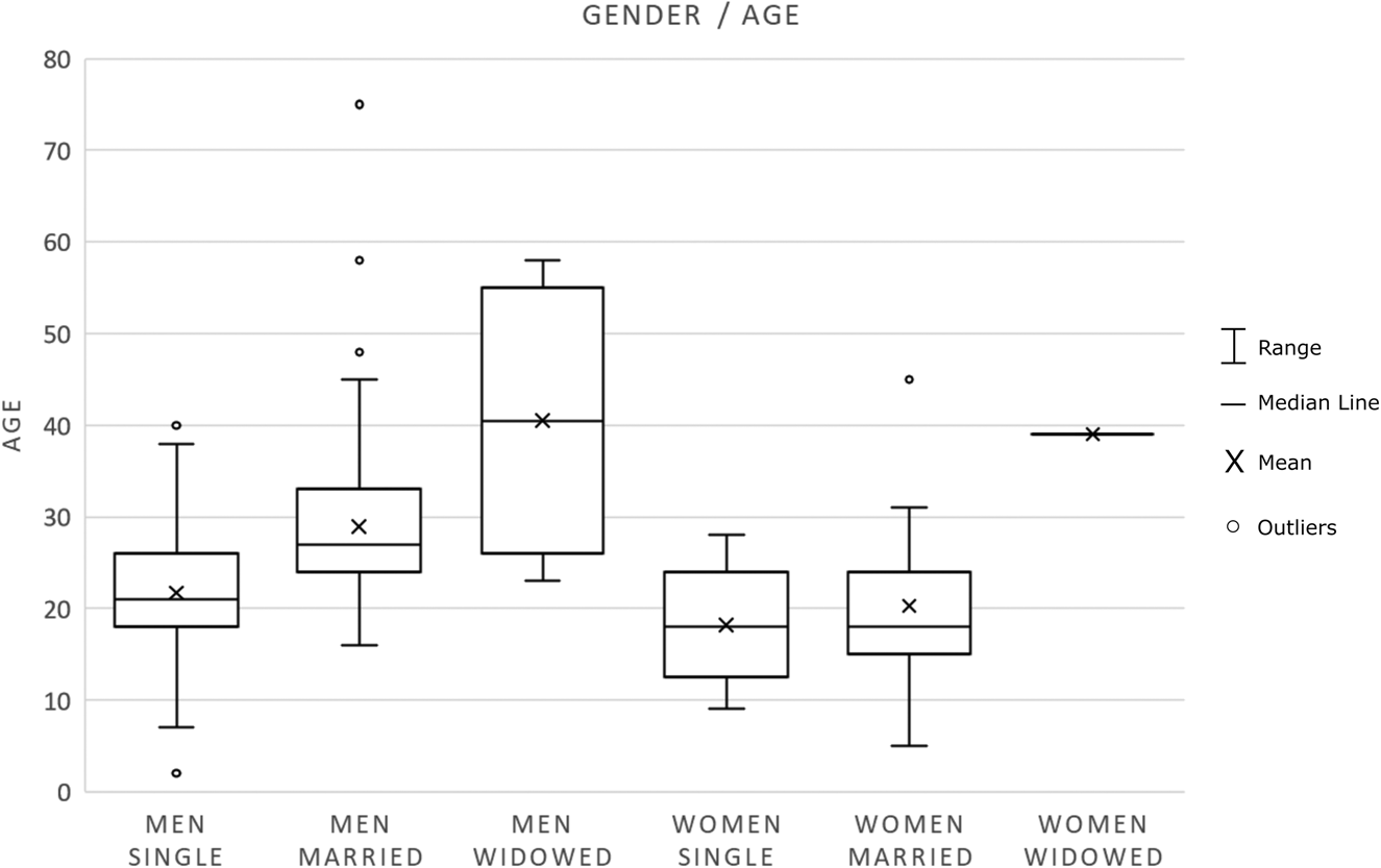
On the other hand, 42.9 percent of all women were under 18 years old. For both genders, migrants over forty represent only 5 percent of the total. The young age of migrants was undoubtedly a relevant factor in shaping the labor relations established in Chuquicamata.
Literacy, Trade, and Professions
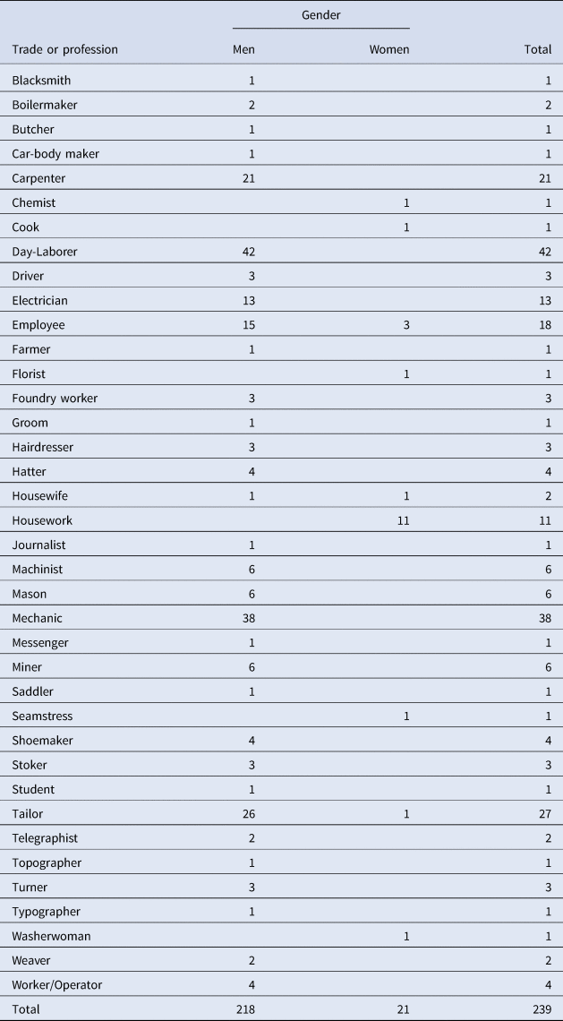
The data on trades and professions of Bolivian migrants display great diversity, although day laborers dominate within the total (Table 2). The distinction by gender reveals a significant male presence of day laborers (19.3 percent of the total number of men), mechanics (17.4 percent), tailors (11.9 percent), carpenters (9.6 percent), employees (6.9 percent), and electricians (6 percent). These six professions account for 71.1 percent of the total trades reported by male migrants. In the case of women, the trade or profession most represented is housework (51.6 percent of the total number of women), followed by the employee category (14.3 percent).
Trade or Profession by Gender Declared by Bolivian Migrants. Source: Authors’ elaboration from AHUCN files.
We note that 42.3 percent of all Bolivian migrants (men and women) had professions or trades within the tertiary sector of the economy; that is, services subsidiary to mining or trades associated with daily life within a company town (the percentages are quite different according to gender, 37.2 for men and 95.2 percent for women). Within this framework, 86.6 percent of migrants indicated they knew how to read and write (Figure 9). The proportion is higher for men (89.4 percent) than women (57.1 percent of the female total), which probably impacted access to specific administrative jobs.
Literacy by Gender and Civil Status. Source: Authors’ elaboration from AHUCN files.

Family Networks
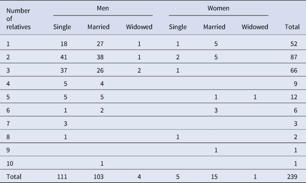
Among all registered Bolivian migrants, 85.8 percent declared to have one, two, or three relatives already living in Chile (Table 3), testifying to the intensity of family networks established during the first half of the twentieth century between both sides of the border. These networks were likely essential for migrant workers’ integration in the new labor-intensive mining context.
Number of Relatives in Chile by Gender and Marital Status of Bolivian Migrants. Source: Authors' elaboration from AHUCN files.
Summary
In summary, the data recorded in the AHUCN bureaucratic documents indicate that Bolivians who migrated to Chuquicamata were mainly literate males associated with professions and trades in the tertiary economic sector. Many already had family networks in Chile, who primarily arrived in different migratory waves during the first years of the twentieth century. Migration records also suggest that Bolivian workers had close family ties with their homeland. As Carmen Salazar-Soler has shown for mining contexts in Peru: “The situation of mineworkers presents a particular complexity since in many cases the mines are in traditional Andean areas and migration to the mine, often close to the community of origin, does not necessarily mean a definitive break with the previous peasant condition; some of the workers go back and forth between the mine and the countryside.”Footnote 50 Ethnographic studies find the redefinition of a new identity in these relationships between the migration process and working conditions. In her ethnographic study in the tin mines of Bolivia, June Nash pointed out that this identity is also closely linked to the living conditions in the mines and, more specifically, to the isolation of mining centers in the economic geography of each country.Footnote 51 Likewise, mining operations in Chuquicamata had not prevented miners from practicing a kind of seasonal migration that temporarily brought them back to their homeland. The characteristics of Bolivian migration to Chuquicamata thus impacted the labor relations and social organizations within the mine and its company town.Footnote 52
Bolivian Social and Labor Life in Chuquicamata
According to Bolivian political scientist Loreta Telleria, the indigenous people in Bolivia were considered a “war factor.”Footnote 53 The soldiers’ greatest enemy was the indigenous people “who constantly revolted in western Bolivia and against whom they had to act efficiently to guarantee political order.”Footnote 54 The characterization of Bolivian migrants allows us to understand some of the tensions and conflicts that occurred in Chuquicamata. The Chilean perception of Bolivian migration was very dismissive.Footnote 55 The war led to a process of the racialization of the defeated countries’ populations. After the War of the Pacific, the Chilean government sought to conceive of the nation as a homogeneous unit, as a “white country”; the rest were “Indians.” The Chilean theorist Hernán Vidal refers to this as a foundational myth, “the birth of the white monster,”Footnote 56 a society descended from Europeans that excluded indigenous populations. This idea of “whiteness” was a political illusion, “a narrative of a sacredness”Footnote 57 based on scientific anachronism. Xenophobic and racist images were published and circulated in the mining centers and press columns. For example, the Antofagasta newspaper El Abecé spoke of the Bolivian laborer as “(…) being semi-wild, of an inferior race, and so cheap that he caused wages to fall.”Footnote 58 The newspaper also distinguished between the Aymara and Quechua ethnic groups living in Bolivia, the latter being portrayed as “less strong and smaller than the Aymara, whose language is sweet and nasal, the other rough and guttural.”Footnote 59
During the Guggenheim ownership, Chuquicamata was inserted within an international and multilingual context, among them the Quechua language “of the altiplano with the stench of coca and peanuts.”Footnote 60 Yugoslavian, French, American, Chilean, and Chinese workers coexisted with “the Indian woman of the Altiplano with its wide and bulky skirts and its breeding on the shoulder.”Footnote 61 However, while these migrants worked mainly in merchant activities, Bolivians worked in mining as day laborers and mechanics, some with boilers, a dangerous section of the mine.Footnote 62 In 1921, El Abecé published a letter written by workers in Chuquicamata that spoke about the sacrificial labor conditions with these boilers and the machine house: “Work is carried out in open air, and because it is already approaching a freezing winter, which is unbearable in this mine due to the tremendous cold and the great winds, the workers in these two sections we suffer horribly.”Footnote 63 Work had to be abandoned on some occasions because of adverse climatic conditions. The workers requested roof construction in those sections of the industrial complex. They feared that illnesses derived from the extreme cold at high altitudes would worsen the situation due to the company's neglect, which “does not pay our salaries, causing the ruin of our homes.”Footnote 64
In August 1919, the Bolivian newspaper La Verdad commented on the practices of recruiting Bolivian workers, indicating that they had found a person in charge of sending to Chuquicamata “every worker who accepts his promises.”Footnote 65 For such purposes, the recruiter's strategy was to send small groups by train, with an average of four people daily. Thus, “they resort to the human commerce of the Bolivian market.”Footnote 66 The recruiter was described as a “merchant of the naive,” and his business consisted of “taking the cheapest, who do not know about the organization (…) who accept the first thing offered to them.”Footnote 67
In Chuquicamata, Bolivians were also stigmatized for their coca consumption, which was considered a moral problem, as was alcoholism: “The influence of the Bolivian Indian (…) has been the determining cause of the spread of cocaine use, not in the form of specifics previously prepared, used by addicts of the vice, but in a natural form, so to speak, consisting of chewing the dry leaves of the coca.”Footnote 68 In these circumstances, both a social problem and a culprit were created. For contemporary authors, the consumption of coca leaves makes the stomach “insensitive to hunger, thirst, and fatigue, which is why its use is frequent,”Footnote 69 producing “an anesthesia (…) a problem of great consequences for the growth of our country.”Footnote 70 Bolivians were frowned upon not only because of their coca leaf consumption but also because of their alcohol consumption and cultural beliefs. They were accused of consuming low-quality concoctions that generated quarrels among “superstitious Bolivian Indians,”Footnote 71 who preserved “old rites and secular practices that Christianity has not been able to banish from their rude mentality.”Footnote 72 Moreover, as contemporary writer Ricardo Latcham commented with a racist tone, “These people profess, in their way, the Catholic religion; but they often confuse the limits of rational faith with those of the idolatries, superstition, and crude fetishism of the natives.”Footnote 73
The Bolivians’ participation in labor was confronted with arbitrary decisions from the American agents who controlled the mine and the company town. According to Angela Vergara, the company town of Chuquicamata applied internal regulations, “strict shift systems and foreign patterns.” Thus, daily life, social life, and private life “were marked by work, geography, and a small social world that left little room for privacy.”Footnote 74 The control of daily life was total, as illustrated by the event in January 1917, when three Bolivian families were evicted from their homes on a cold morning “for refusing to work on Sundays at the simple salary of the current day.”Footnote 75
The American writer Lilian Elwyn Elliott Joyce, who visited the mine in 1920, mentioned: “Chuquicamata employs about 2000 Chilean or Bolivian, with a small sprinkling of Peruvian, workers housed under deplorable conditions.”Footnote 76 In her description of the company town, Joyce added, “Many of the huts are made of sheet iron, with partitions dividing the rooms; the floors are of mud, and an opaque substitute for glass obscures the window space in too many cases.”Footnote 77 She also commented that there were too few houses that offered better conditions to the native workers and warned of the potential discontent caused by such housing conditions and by social and material segregation. However, she specified that the wages were higher than those of other copper mining centers, such as the El Teniente mine in southern Chile. However, in Chuquicamata, the cost of living was higher. Coal, for example, “is almost unknown, and the employé's (sic) womenfolk are seen cooking over a charcoal brazier, or a fire made of an umbelliferous plant from the mountains (yareta), or a few pieces of wood brought from long distances.”Footnote 78
Chuquicamata had different neighborhoods (Figure 10).Footnote 79 Las Latas was where the Bolivian population lived, a deteriorated and precarious sector: “It looked like a gigantic dovecote with its tiny cube-shaped houses.”Footnote 80 This sector, “whose condition gives a miserable impression,”Footnote 81 was considered much inferior in quality compared to the neighborhood called Pueblo Hundido and incomparably worse than the Chilean workers’ neighborhood called Los Adobes. In Latcham's disdainful commentary, he stated that “these arrangements must be inferior on the Bolivian side, for their inhabitants have no idea of the most elementary principles of hygiene.”Footnote 82 Las Latas consisted of “two narrow houses where a family composed of several people had to live.”Footnote 83 This area was known as a “Bolivian camp.”Footnote 84 The saturated and inferior sewage system and the lack of bathrooms generated multiple discords among its inhabitants. “The sewage is thrown into the street, causing an unbearable smell when passing through it (…) the inhabitants get sick with pneumonia or rheumatism, and many have died due to this unhealthy housing condition.”Footnote 85 As Klubock mentions, “Bolivians lived in a segregated community within the copper-mining camps and maintained a separate cultural world with their social clubs, mutual aid societies, and political clubs.”Footnote 86 Bolivians lived in the camp's most precarious neighborhood, Las Latas, officially called Townsite Type D-2 by the Americans (Figure 11). The sector was characterized by its narrowness and overcrowded population, water scarcity, the absence of bathrooms, the sharing of living spaces with animals, and the nullity of privacy. This labor and housing precariousness saved global production costs. The Bolivian workers, described as “Indians,” subsidized a mining economy with their strength and bodies. This ethnicity and racialization of Bolivian workers, in the words of Achille Mbembe, “is the raw material with which difference and surplus are made.”Footnote 87 Ethnic-labor subsidiarity was made possible by the social context of colonial features, where stigmatization and disqualification generated a political control engine, maintaining the threat, expulsion, and brutalization of the migrant population.
Plan of the so-called Campamento Nuevo de Chuquicamata, existing between 1916 and 1950. It identifies the neighborhoods resulting from territorial management and segregation based on labor hierarchy. Source: Authors’ elaboration based on several plans from the Engineering Department of The Chile Exploration Company, Chuquicamata, Archivo Gobernación Provincial de Tocopilla, Chile.
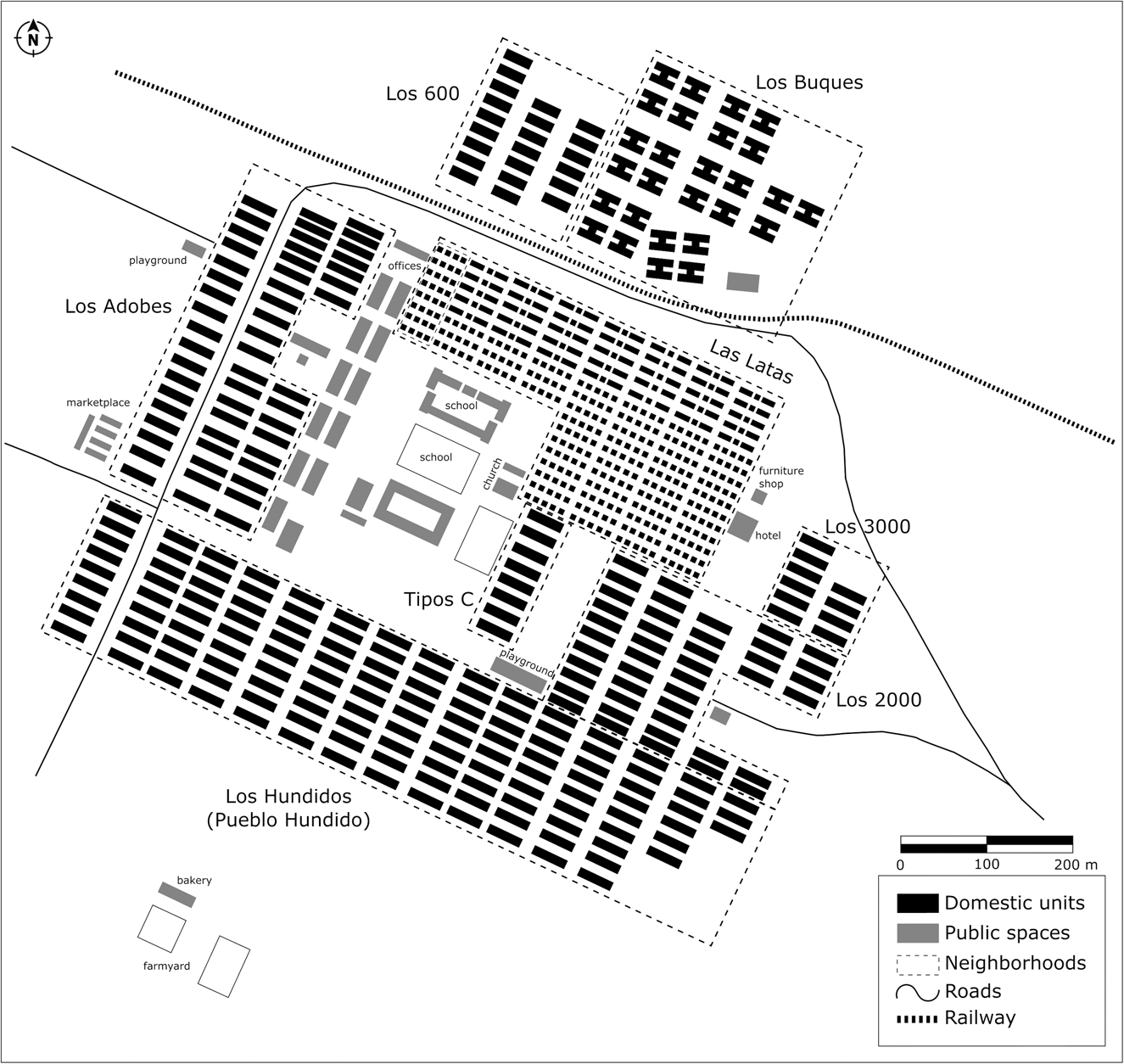
Las Lata's neighborhood (top) was built in 1916, formally called Town Type D-2. It was the place where many of the Bolivian migrants resided. (Below) Las Lata's neighborhood in the 1940s and 1950s. Source: First author's archive.

At the Guggenheim mine, the Bolivian population was considered a second-class labor force who, in addition to suffering from racial and ethnic discrimination, performed underpaid and highly-risked jobs: “There was a strong population of Bolivian Indians, fierce competitors of the Chileans in their extraction work since they were satisfied with little salary and did not have great material demands, leading the North American capitalists sometimes to prefer them.”Footnote 88 A barbarization of the other emerged, a kind of cross-cultural judgment.Footnote 89 For example, in January 1917, some Bolivians worked on installing pipes from the headwaters of the Toconce River (4,250 meters above sea level) to supply the camp with fresh water. Most contracted pneumonia “in the cold weather of this region at the foot of the mountain range.”Footnote 90 These workers suffered coughing, pain, and heavy bleeding of the lungs, and many died. One of the workers who eluded death was the Bolivian Pedro Sandoval, who reached Calama “where he received medical attention from his own family.”Footnote 91
Historical references display a reality of labor and socio-economic precariousness. Bolivian workers assumed this reality and gave their bodies and energies so the Guggenheim mining project could be successful. Risk exposure was a constant, and as Weitzner pointed out, “the State guarantees the exacerbation of this risk,”Footnote 92 feeding the notion that ethnic groups were an exploitable migrant population. Legally attached to Bolivia but suffering from the adjective “Indians,” this population contributed with an indigenous surplus value, an ethnic and labor subsidiarity. As Álvaro García Linera points out, the labor force is not only parameterized but is substantial and sustained: “The worker embodies this merchandise; he will be a merchandise himself.”Footnote 93 This situation increases in a context of disdainful imaginaries in which the colonial body is “affected by both excess and deprivation.”Footnote 94
Characterizing England's industrial revolution, historian Edward Wrigley considered a transition from an “organic economy” to an “economy of mineral origin.”Footnote 95 By “organic economy,” he meant the one driven by animal power and human labor, i.e., the pre-modern era, the age before the fossil fuel engine (coal, gas, oil). These fuels manage new forces, new mechanics, and a new production scale. Therein lies the “economy of mineral origin.” However, in the case of Chuquicamata, we see a fusion of these two types of economy.
On the one hand, we have a mining industry that is a world landmark, with giant Bucyrus shovels breaking the copper mountains and the use of an electrolysis smelter to obtain refined copper. On the other hand, Bolivian workers lived in precarious conditions, working with their bodily strength and suffering severe accident and mortality rates. For example, in 1922, a striking total of 3,218 workers got injured in accidents.Footnote 96 As productivity reached unprecedented heights, accident rates increased, leading to the hospital's expansion (Figure 12). According to Diego Vergara, a Chuquicamata chronicler in 1923, most accidents resulted from inexperienced and careless workers handling new machinery, chemicals, and mineral dust.Footnote 97 Thus, the workers’ confrontation with a novel and unprecedented technological reality created labor risks and vulnerabilities. The above portrays industrialization's dissonances, the workers’ bodies being at the disposal of mining capital.
Copper production and work accidents between 1915 and 1925. Source: Authors’ elaboration based on Diego Vergara, Chuquicamata Un estado dentro de otro Estado (Santiago, 1923).

Mine Ownership Transfer, Migrant Decline, and Organizational Processes
The historical archives show that the increase in Bolivian migration is inscribed in the pre-industrial stage of Chuquicamata. This migration increased significantly in 1912 during the Guggenheim ownership and resulting industrialization. In February 1923, the Guggenheims abandoned copper mining and transferred the Chuquicamata ownership to the firm Anaconda Copper Mining Co.,Footnote 98 and projected new extractive activities in the Atacama Desert's saltpeter industry.Footnote 99 This period coincides with a decrease in migrant entries. They built new facilities in 1925 and 1927 with a commitment to increasing the mechanization of the mining processes.Footnote 100
Chilean workers highly discriminated against Indigenous Bolivian workers. These tensions “were exacerbated during the 1920s by the North American company's strategy of hiring Aymara Bolivians – who were believed to be more docile than Chileans – at lower wages, a method that British nitrate companies had employed to undermine miners' labor organizations.”Footnote 101 This practice, referred to as “enganche”Footnote 102 in popular slang, was used in Bolivia to attract and recruit workers. In November 1923, El Abecé de Antofagasta commented: “Bolivian day laborers and mechanics arrive ‘enganchados’ at the mine, through the railroad that connects Antofagasta with Uyuni […] these Indians are submissive and hard-working and do not respond to the claims promoted by agitators and strikers.”Footnote 103 US businesspeople replicated this practice in other countries, especially in Mexico.Footnote 104 Changing arrangements, low wages, and mistreatments were a constant. Racialized and low-wage labor was fundamental for economic development and capital accumulation. In the Atacama Desert, this made the Bolivian workers “enter into suffering all kinds of miseries and accept the lowest existing wages when they went with the illusion of high wages.”Footnote 105 According to the newspaper El Mercurio, the situation of Bolivians in Chile was uncomfortable and included daily inconveniences.Footnote 106 In 1923, Bolivian soldiers illegally entered Chile because of the mistreatment of Bolivians: “The Bolivian government has been complaining to our government (Chile) about certain abuses committed by the police against Bolivian citizens.”Footnote 107
With the legislation of 1924 and the creation of the General Labor Office (Law 4053), union activities carried out by Chilean workers increased and favored the recognition and protection of labor rights. In January 1923, Bolivian workers formed the Bolivian Centre of Mutual Aid of Chuquicamata (CBSM) in response to labor precariousness and hostility toward them and the vindicating activities of the Chilean workers. This social organization sought “to bring together the entire Bolivian element without distinction of social class, religion, or politics, seeking the moral, cultural, physical and economic improvement of its associates.”Footnote 108 For these purposes, the associates were required to show good conduct, and a superior gave a certificate of honorability. They also had to be over fifteen years old and less than sixty-one not to have a chronic or contagious disease and a good reputation. The CBSM provided mutual support through cash bonuses, for which each member contributed a monthly fee. While the association instructed its members not to ask for help “when the illness comes from alcoholic excesses,”Footnote 109 it supported them in case of accidents or illnesses. Furthermore, “if the member was separated from his employment or work without justified cause, he would be able to make the most effective arrangements until his rehabilitation is achieved.”Footnote 110 In addition to providing financial help to families with economic problems and wanting to return to Bolivia, the CBSM helped cover the associates’ mortuary expenses.
Bolivian migrants organized themselves to cope with asymmetric labor relations generated by nationalism, chauvinism, xenophobia, and racism. They were accused of robbery and misconduct, often wrongly, as was the case of the shoemaker Encarnación Caro. After being denounced by another worker for hiding goods stolen from the company, his house in the Los Adobes neighborhood was raided on March 27, 1920, by order of the Chuquicamata police. They found a “large amount of leather, shoe soles, and articles proper to his trade as a shoemaker, plus an electric iron.”Footnote 111 In addition, a hygienist discourse also supported the semantics of disdain typical of the Chileanization of the territory. Bolivians were accused of uncleanliness and of carrying diseases such as exanthematic typhus. In 1921, El Mercurio de Valparaíso stated: “The origin of the cases comes from the contagion transmitted by the Bolivian Indians.”Footnote 112 Such newspaper statements contributed to the widespread negative representation of Bolivian migrants.
In the mid-1920s, the CBSM dissipated due to the decline in Bolivian entries and the return of several families to Bolivia. In addition to the mine's change of ownership, the decrease in Bolivian migration coincided with the intensification of labor condition regulations. In 1928, through the Supreme Decree no.1846, the organic rules of the General Labor Inspectorate were approved, an entity responsible for monitoring labor conditions in each Chilean province. In 1931, creating a new Labor Code encouraged the unionization of employees and workers at Chuquicamata (Law 4057), consolidating the protection of contracts and social security. In the new Chilean legal framework, workers and employees had to dissolve their old organizations, allowing new workers’ unions to emerge: Sindicato Industrial de Planta (January 15, 1931), Sindicato Empleados Particulares (May 4, 1931), Sindicato Industrial de Mina (June 30, 1931), Sindicato Industrial de la Termoeléctrica de Tocopilla (September 3, 1933) and Sindicato de Empleados de la Chilex (October 22, 1941).Footnote 113 Following the historian Francisco Zapata, the unions’ first demands had a robust nationalist trait, asking the company to hire only Chilean workers. In addition, unions demanded improvements in working environments, an increase in salaries, and “the right to present demands and the need for leaders to have a legal right to carry out their activities without fear of being dismissed.”Footnote 114
As Thomas Klubock pointed out, “Chilean workers’ antagonism to Bolivians in Chuquicamata drew on decades of national and ethnic hostilities in the Chilean north.”Footnote 115 Tensions were deepened by the impacts of the 1921 international crisis, caused by the fall of copper prices, which plummeted in nominal terms to below 10 cents per pound, one of the effects of the Great War and its global economic instability.Footnote 116 During that year, Chuquicamata produced 26,999 tons of electrolytic copper, almost half the previous year: 55,567 tons. The crisis generated voluminous migrations. In April 1921, El Abecé reported dismissing 278 workers with their families, totaling more than 500 people.Footnote 117 Bolivian entries decreased due to changes in the mine's ownership, the strengthening of labor mechanization, and increased legal controls over companies. Chuquicamata's industrial beginnings correlated with the precariousness of living conditions, but as the quality of life improved, coincidentally, Bolivian migrants began to decline. In addition to this situation, the tightening of the border's controls, increased by police posts and customs control requirements from the 1920s onward, played a role in the decreasing number of Bolivian workers arriving at Chuquicamata.
Conclusions
During the twentieth century, capitalist expansion in the Atacama Desert fostered an intense cross-border migration.Footnote 118 The mining boom required an inexpensive labor force. Although the local Bolivian population had fled the Atacama Desert following the War of the Pacific, almost thirty years later, many Bolivians returned to work in the Guggenheim mine, performing the most dangerous tasks and living in miserable conditions. Analysis of newspapers and documentary archives found at the AERCI allowed us to identify and characterize both statistically and qualitatively 239 Bolivian migrants who worked for the Chile Exploration Company between 1912 and 1925. An examination of Bolivian migration to Chuquicamata allowed us to characterize the company town's mobility and assess the importance of Bolivians as a fundamentally organized workforce for its development.
Archival documents allowed us to identify the origin, age, trades, gender, marital status, literacy, and years of entry of Bolivians living in Chuquicamata from 1912 to 1925. Data revealed the extent of the migratory phenomenon and the migrants’ participation in the mining development through specific trades—such as day laborers, mechanics, and services—or complementary trades—such as tailors and carpenters. Bolivian migration to Chuquicamata comprised a mainly male, literate population associated with professions and trades in the tertiary economic sector. In general, they already had family networks in Chile, whose members had arrived in different migratory waves during the first years of the twentieth century.
Documentary analyses thus allowed us to characterize a singular historical process in a territory altered by a war that had affected and displaced the local population. Bolivian migrants returning to work in Chuquicamata in labor precariousness and subaltern working conditions were labeled as foreigners and “Indians.” We discussed this historical process through ethnic-labor subsidiarity resulting from ethnic discrimination and expressed in mining work's disposition and physical costs. From the presence of Bolivian workers in Chuquicamata arose tensions and conflicts between American employees and Chilean workers. Bolivians were constantly discriminated against, and contemporary chronicles published in regional newspapers reproduced a xenophobic discourse toward them. Historical accounts undervalued the importance of the Bolivian workforce for the maintenance and development of copper mining in Chuquicamata.
Racism and the objectification of “Indians” guided the new labor and social relationships between Chilean and Bolivian workers during the Guggenheim ownership era. Following the creation of the General Directorate of Labor in 1924, there was an increase in the protection of labor rights and the number of unionized Chilean workers. Labor conflicts, protests, and strikes led by Chilean workers intensified alongside an increasingly xenophobic discourse against Bolivian workers. In 1925, Bolivian migration decreased mainly due to changes in mining production structures and the mine's ownership, i.e., the Guggenheim family's withdrawal from the Chuquicamata. The war altered the mining territory and the social context that articulated labor relations. This subsidiarity of the Bolivian workforce sustained the expansion of US capitalism in the Chuquicamata copper mine and the Atacama Desert. The examination of migratory documents has made it possible to ascertain the identity of migrant workers who, in a context of precarious living and working conditions and discrimination based on their origin and customs, organized themselves and played a substantial role in the development of one of the world's largest copper mines.


 Open access