

Reconstruction of the former extent of glaciers is frequently used as a means to estimate the magnitude of past climatic variations. Typically, modern equilibrium-line altitudes (ELAs) are determined from an analysis of existing glaciers. After the limits of former glaciations have been mapped, ELAs for these earlier glacial advances may be estimated from an assumed accumulation-area ratio (AAR) or from a toe-to-headwall altitude ratio (THAR) (Reference MeierdingMeierding, 1982), Comparisons of present and former ELAs, when used in conjunction with modern meteorological data, can often permit limits to be placed on the magnitude of climatic changes required to produce the calculated variation in the ELA.
A primary assumption in these reconstructions is that glaciers have not been topographically constrained and that they have been as free to advance in the lower segments of their valleys as in the upper parts. Thus, valley geometry becomes an important factor in determining whether or not this assumption is valid. Numerial modeling of longitudinal profiles of valley glaciers (Reference NyeNye, 1952; Reference MathewsMathews, 1967; Reference Schilling, Hollin, Denton and HughesSchilling and Hollin, 1981) and calculations of average shear stress experienced at the glacier sole (Reference NyeNye, 1965; Reference WeertmanWeertman, 1971) indicate that cross-valley shape factors influence the thickness of a glacier and the declivity of its surface. Valley shapes that inhibit ice advance lead to over-steepened and over-thickened terminal zones of glaciers. If bedrock geology significantly restricts the ability of glaciers to advance beyond certain limits, ELA reconstructions will not accurately reflect climatic changes.
Excellent examples of the influence of bedrock and structure on glacial limits are found in the vicinity of Leh in the Ladakh-Zanskar region of the north-western Himalaya (Fig. 1). The ranges on both sides of the Indus River are aligned from west-north-west to east-south-east. The crest of the Ladakh Range averages about 5400–5700 m a.s.l. The parallel ridge crest of the north-eastern flank of the Zanskar Range rises to similar heights on the south-western side of the Indus River. In both ranges, numerous cirque glaciers range in area from 0.5 to 2 km2. Their snouts are located on the north-west- to north-east-facing slopes, generally above 5100 m. Infrequently, small glaciers and permanent icefields of less than 0.5 km2 are found on southern exposures along high ridges above 5500 m. In most years, ablation affects the entire annual snow-pack, with superimposed ice (Reference MüllerMüller, 1962) forming above the ELA. At present, the steady-state ELA in cirques with a north-eastern to north-western orientation appears to lie between about 5200 and 5400 m.
a. Generalized location map of the Himalaya and the adjoining Indo-Gangetic Plain. The box marks the location of the study area in Ladakh.
b. Location map of the study area in Ladakh along the upper Indus River. The Indus valley at 3250 m altitude is more than 2500 m below the crests of the surrounding ranges. The altitudinal ranges associated with each named range indicate the average height of the summits in that range, as well as the high passes. The highest peak in the region is Stok Kangri at 6120 m in the Zanskar Range.

Few meteorological data are available from this region of the Himalaya. The widely scattered meteorological stations (Leh and Dras) are at or near valley bottoms, frequently more than 2000 m below the adjacent mountain summits. Thus, any summary of modern climatic conditions affecting the glaciated summits in the Ladakh area is, of necessity, rather speculative and generalized. At Leh, Ladakh (Fig. 1), the mean annual precipitation based on historical measurements is about 80 mm (Reference FlohnFlohn, 1958). However, the higher parts of the Ladakh and Zanskar Ranges receive an indeterminately greater quantity of precipitation than do the adjacent valley bottoms. The general aridity of this alpine environment is indicated by the barren mountainsides, devoid of all but the most hardy vegetation.
For the purpose of comparing the present and past glacial extension in the Ladakh and the Zanskar Ranges, the absolute amount of precipitation and seasonal temperatures in the glaciated zone is less important than the presence or absence of marked differences in the climatic regimes. In the absence of direct measurements, potential differences can be assessed by comparing (a) the altitude of transient snowlines as seen in Landsat imagery of the study area at different times of year, (b) the distribution of modern glaciers, and (c) observations of snowfall patterns during late summer and autumnal field seasons. The strong similarities between both ranges in each of these factors indicate that significant climatic differences, if any, are undetectable through these comparative features. Furthermore, our observations indicate that the modern ELAs lie within about 50–100 m of each other for the parts of the two ranges in the study area. Thus, the climate in the glacierized zone, insofar as it is related to these features, appears to be very similar in both ranges.
Bedrock Geology
Geologic mapping of the Ladakh and Zanskar Ranges (Fig. 2) reveals striking contrasts in the bedrock assemblages that have been juxtaposed along the Indus suture zone in this area (Reference GansserGansser, 1976, Reference Gansser, Aubouin, Aubouin, Debelmas and Latreille1980). The elongated flattened summits of the Ladakh Range are developed in the granodioritic intrusive rocks of the Ladakh batholith (Reference GansserGansser, 1964; Reference Frank, Frank, Gansser and TrommsdorffFrank and others, 1977; Reference Honneger, Honegger, Dietrich, Frank, Gansser, Thoni and TrommsdorffHonegger and others, 1982). The valleys along the flanks of the Ladakh Range are quite broad (0.5-2 km wide) and the water courses in these valleys debouch on to an extensive system of coalescing alluvial fans at the mountain front (Reference FortFort, 1982).
Geologic map of the study area, indicating informal formation names, formational contacts, and the geologic cross-section A-B. All contacts depicted are tectonic, except for the erosional contacts bordering the Indus alluvial fans (modified from Reference BaudBaud and others (1982)). A longitudinal cross-section (below) from the crest of the Zanskar Range towards the Indus River to the north (A–B). Formation designations: 1, Stok Kangri conglomerates; 2, Chogdo flysch; 3, Sumdo molasse; 4, Hemis conglomerates and multicolored molasse. The subsidiary summits of the northern Zanskar Range are developed in the indurated multicolored molasse unit. The cross-section terminates in the north at the contact with the Indus alluvial fans. Wide valleys persist through the Chogdo flysch and Sumdo molasse. Steep-sided canyons are incised through the multicolored molasse. Cross-section is modified after Reference BaudBaud and others (1982).
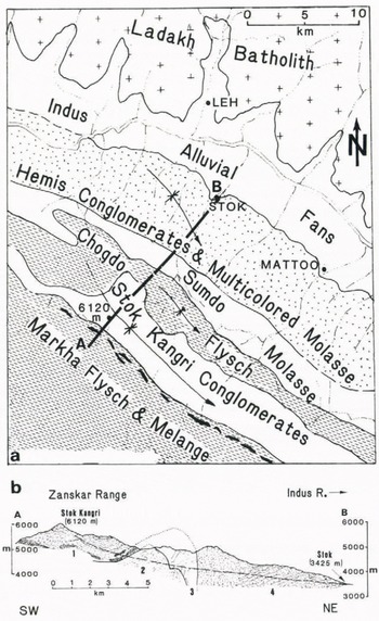
South of the Ladakh batholith and parallel to its west-north-west to east-south-east elongation, molasse and flyschoid rocks dominate the south-western margin of the Indus valley (Fig. 2), where they form a broad band 10–15 km wide (Reference TewariTewari, 1964; Reference Bassoullet, Bassoullet, Colchen, Marcoux and MascleBassoullet and others, 1978; Reference FuchsFuchs, 1979; Reference BaudBaud and others, 1982). The basal northern part of the molasse is dominated by the Hemis conglomerates and the indurated sandstones of the “multicolored molasse” (Reference BaudBaud and others, 1982). These steeply dipping strata uphold the outermost subsidiary summits of the Zanskar Range (Fig. 1), forming a continuous crest, except where dissected by through-flowing, narrow (< 100 m) drainages. Along their south-western contact, the “multicolored molasse” abuts the fissile shales of the Sumdo molasse and Chogdo flysch (Reference BaudBaud and others, 1982).
The abrupt lithological changes between the multicolored and Sumdo molasse have resulted in highly contrasting valley morphologies. The steep-walled canyons cut through the vertical strata to the north-east and give way to rounded hillslopes and broad valleys eroded in the Sumdo molasse. These gentler slopes rise from the mouths of the canyons at 4100–4200 m across the shales toward the crest of the Zanskar Range. The summits themselves (5700-6100 m) are developed on the overlying resistant sandstones and conglomerates of the Stok Kangri molasse (Fig. 2) (Reference BaudBaud and others, 1982).
Former Glacial Limits
Because the Zanskar and Ladakh Ranges combine (1) strong similarities in height, climate, and present glaciation with (2) distinct contrasts in bedrock lithologies and structures, they provide a good experimental setting in which to observe the effects of bedrock geology on former glacial limits on opposite sides of the Indus River. In the Ladakh Range, broad, blocky Neoglacial morainal complexes are preserved along the termini of the present glaciers at around 4950–5200 m. These are usually sharp- and multi-crested steep-walled complexes up to 150 m thick and nested close to the present glacier snout (Fig. 3). In several valleys (e.g. the Basgo valley; Fig. 4), another set of lobate moraines has been observed between 4300 and 4600 m. These are typically subdued broad-crested ridges about 10–20 m thick with abundant solifluction debris along their flanks. These moraines also show a higher percentage of weathered boulders, more desert varnish, lower surface-boulder frequencies, and limited soil development. Given these characteristics and their position over 500 m below the Neoglacial moraines, these moraines are attributed to a recessional stage of the last glaciation, informally designated as the “Kar Stage” (Reference Fort and GuptaFort, 1983).
A typical glacier along the crest of the Ladakh Range. Here, at the head of the Basgo valley, the summits are about 5700 m in elevation, and the glacier descends to about 5250 m. Like most of the other glaciers in this area, this glacier has a largely debris-free surface, blocks of stagnant ice have been isolated at its toe due to recent recession, and very thick (150-200 m) Neoglacial moraines are nested around its terminus. Note the extensive cones of frost-shattered, slush-flow debris and the overall aridity of this alpine region where melt-water run-off is minimal.

Distribution of modern and former glaciers in the Ladakh and Zanskar Ranges. Modern glacier positions are based on ground observations and satellite image interpretation. The former extent of glaciers on the north side of the Zanskar crest and on the south side of the Ladakh crest are outlined by dashed lines. Moraines attributed to the late Pleistocene maximum advances and to a recessional stage are depicted where they have been observed. The striking asymmetry in the reconstructed former glaciation is evident in the contrasting spatial and longitudinal extent of late Pleistocene glaciers.
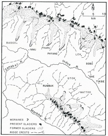
In nearly every valley draining the south flank of the Ladakh Range between Leh and Basgo (Fig. 4), remnants of massive terminal moraines are located at elevations ranging from 3300 to 3650 m (Reference DainelliDainelli, 1922; de Reference TerraTerra, 1935; Reference FortFort, 1978, Reference Fort and Gupta1983). In most places, these moraines are over 50 m thick and form conspicuous ridges of weakly consolidated till. The moraine lying 3 km north of Leh, exceptionally well preserved, forms a continuous crest for several kilometers, except where incised by a medial drainage (Fig. 5). Although more fragmentary in other valleys, all of these low-level moraines generally comprise “fresh” boulders exhibiting limited surface weathering, very restricted soil development, and well-preserved crest morphology. If compared with the Neoglacial and recessional moraines previously described, these suggest an apparent reversal of weathering characteristics, which can be explained by the vertical bio-climatic zoning of this part of the north-western Himalaya (Reference FortFort, 1981). The aridity of the Indus plain and the adjacent low terrains reduces the rate of weathering of the older lower moraines, whereas colder moister conditions of the alpine heights favor the enhanced weathering of the younger moraines. Nevertheless, in the context of other glacial deposits previously described from this region (Reference FortFort, 1978, Reference Fort and Gupta1983), the lower-altitude terminal moraines are interpreted as representing the maximum advances of the last glaciation and have been informally designated as the “Leh Stage”. (Reference Fort and GuptaFort, 1983).
The massive well-preserved Leh moraine is shown on the right of this photograph. The moraine lies about 3 km north of Leh at 3650 m altitude. The crest of the Ladakh Range in the background lies between about 5500 and 5700 m. The irrigated and relatively fertile outwash fan stands in sharp contrast to the adjacent alluvial fans and mountainsides that are devoid of most vegetation. The rounded spurs and summits are very typical of those in the Ladakh Range that are developed on coarse-grained intrusive rocks. Their erosional morphology is attributable primarily to frost action and mass-movement processes (Reference Fort and GuptaFort, 1983). They do not appear to have been strongly modified by Pleistocene glacial activity.

In the studied part of the Zanskar Range, both recessional and Neoglacial moraines are also present in the alpine valleys above Stok and Mattoo (Fig. 4). Like those in the Ladakh Range, the Neoglacial moraines are very fresh in appearance and often 100 m or more thick. The innermost moraines are frequently ice-cored. They are clustered in complexes, often 200 m or more in width, and are nested adjacent to the modern glacier termini around 4900–5150 m. Some 500 m lower in the valleys, recessional moraines form broad (100–200 m wide), multiple-crested complexes comprising subdued arcuate ridges, 10–20 m high. These are particularly well preserved in the wide valleys of the alpine zone around 4400–4500 m in the upper Mattoo valley. Still lower in the Stok and Mattoo valleys, remnants of terminal moraines are located at around 4100–4200 m adjacent to the mouths of the canyons cut through the multicolored molasse (Fig. 6). The original morainal debris, up to 120 m thick, has been deeply dissected by post-glacial fluvial activity. Within the canyons, the presence of tors and well-developed desert varnish, as well as the lack of both large- and small-scale indicators of glacial activity, e.g. roches moutonnées and tills, indicates the glaciers are unlikely to have entered these canyons. Consequently, the lowest occurrences of till and preserved moraine fragments observed at the head of the canyons should correspond to the terminal position of the late Pleistocene maximum advance (Leh Stage). In summary, in both ranges, field observations indicate fairly similar altitudes attained by moraines attributed to Neoglacial and last maximum recessional stage (Kar Stage), whereas they reveal a wide discrepancy for the moraine elevations of the late Pleistocene maximum (Leh Stage).
Sketch of the entrance to the Stok Canyon in the Zanskar Range at about 4100 m. In the left foreground are the dissected remnants of the terminal moraine with till exposed along its flanks. On the right, the vertical strata of the multicolored molasse rise from the contact with the Sumdo molasse. The entrance to the canyon is located at the contact in the center of the drawing beyond the moraine. The walls on either side of the canyon rise to over 5000 m.

Reconstructed Elas
Based on the extent of former glaciers, ELAs may be reconstructed using a variety of techniques (Reference MeierdingMeierding, 1982). THARs provide one of the easiest methods for estimating former ELAs, because only two altitudes need to be known for each valley. Since in the Ladakh and Zanskar Ranges these altitudes were available for many valleys, we used THARs most commonly to assess the former altitude of equilibrium lines at different periods. A comparison of ELAs calculated from the altitudinal data presented above illustrates the comparable positions of the modern, Neoglacial, and recessional ELAs in both ranges (Fig. 7). Due to the lack of air photographs and topographic maps for this region, ELAs based on an assumed AAR can rarely be determined with precision, except in a few valleys, where the reconstructed ELA coincides spatially with a feature whose altitude is known from ground observations. For our calculations, we assumed an AAR of 0.65 (Reference Meier, Wright and FreyMeier, 1965), and a THAR of 0.40 (Reference MeierdingMeierding, 1982). In valleys where both techniques were tried, the reconstructed ELAs typically lay within about 100 m of each other.
Longitudinal valley profiles from the Stok and west Mattoo valleys in the Zanskar Range and from the Basgo and Leh valleys in the Ladakh Range. Note that the valleys depicted here are not located opposite to each other geographically but are shown in opposition to facilitate comparison of the glacial sequences and the reconstructed ELAs in each range. The modern glaciers are shown in solid black, followed by successively lower and older stages: Ng, Neoglacial; Rc, recessional; Lp, late Pleistocene maximum. The positions of the Neoglacial and recessional moraines in the Leh valley are approximations. They are visible from the air but are inacessible due to travel restrictions. The reconstructed level of the ELA for each stage based on a THAR of 0.4 is shown on the side closest to the Indus River. Abbreviations are the same as those above but also include the estimated present ELA (Mo).

A comparison of the data obtained (Fig. 7) shows that on both sides of the Indus near Leh, the morainal altitudes and the reconstructed ELAs for the recessional phase of the last glaciation (Kar Stage) are very similar. The variation between valleys in one range is of the same magnitude as the variation between the ranges. Likewise, the Neoglacial limits and ELAs are comparable in both the Zanskar and Ladakh Ranges. However, the reconstructed median ELA for the late Pleistocene maximum advances on the southern flank of the Ladakh Range lies at near 4300 m altitude (Table I), or about 900–1000 m lower than the present ELA. In contrast, in the Zanskar Range, the reconstructed ELAs for the same period lie near 4700 m (Table I), or about 500–600 m below the present ELA. In evaluating these ELA calculations, we emphasize (1) the similarity of the magnitude of the late Pleistocene maximum ELA lowering for the Ladakh Range with the amount of ELA lowering calculated for many other areas of the world (Reference PorterPorter, 1970, Reference Porter1975; Reference AndrewsAndrews, [c1975]), and (2) the anomalous reconstructed ELAs in the Zanskar Range which are 400 m higher than those in the Ladakh Range and which define an apparent ELA gradient that rises more than 13 m/km from north to south between the range crests.

Discussion
In the absence of accurate climatic data, the succeeeding analysis is based on the assumption that similarities in the size, altitude, and configuration of the modern glaciers in both ranges reflect comparable climatic conditions experienced in the alpine regions of each range. However, given the strong southward-rising gradient of the reconstructed late Pleistocene ELA, one must ask whether this reflects an orographically controlled climatic gradient or might it be attributed to tectonic uplift or contrasting glacial geometries.
Strong climatic gradients have been described from the Mount Everest area (Reference WilliamsWilliams, 1983), 1100 km to the east-south-east of Ladakh, where modern and late Pleistocene ELA gradients rise at 7 m/km and 11 m/km, respectively. These gradients rise to the north and are interpreted to represent increasing aridity as the Tibetan Plateau is approached. In contrast to the Mount Everest area, the reconstructed ELA gradient of 13 m/km in the Ladakh area rises towards the south. However, the major source of moisture nourishing this area today derives from the weather systems traversing north-eastward across the Indian subcontinent
It is possible the Pleistocene moisture source for the Ladakh Range was from the north during glaciations, in which case the reconstructed ELA gradient could reflect orographic control. However, this hypothesis is not compatible with the steadily northward-rising cirque-floor altitudes in nearby Kashmir. There, the data indicate the glacial Pleistocene moisture source derived from south of the Himalaya, assuming that regional trends of cirque-floor altitudes generally mimic the trends of orographically controlled climatic gradients (Reference Peterson and RobinsonPeterson and Robinson, 1969; Reference MeierdingMeierding, 1982; Reference Porter, Porter, Pierce, Hamilton and PorterPorter and others, 1983). Therefore, the reconstructed southward-rising Pleistocene ELA gradient in the Ladakh area is unlikely to reflect any true orographic control. Furthermore, the apparent similarities between the ranges in the modern climatic conditions, as well as the comparable altitudes of the present-day glaciers and of the Neoglacial and recessional moraines previously described, argue against a strong contrast in Pleistocene temperature or precipitation.
The possibility that significant post-glacial tectonism differentially uplifted the moraines or headwalls of the Zanskar Range with respect to the Ladakh Range also appears unlikely. There is little evidence to suggest rapid uplift of the Zanskar Range along range-front faults. Indicators of active vertical tectonism, such as extensive fan-head deposition, linear mountain fronts, and undissected fans (Reference Bull, McFadden and DoehringBull and McFadden, 1977) are generally absent. Moreover, the southward displacement of the Indus River west of Leh (Fig. 1) would reflect, if anything, differential uplift of the northern part of the basin (Reference FortFort, 1982). If this potential uplift has occurred since the late Pleistocene maximum, it would serve to reduce, rather than enhance, the altitudinal discrepancies between the terminal moraines of the two ranges. Therefore, recent tectonism cannot satisfactorily account for the discrepancy between ranges in the calculated late Pleistocene ELA.
Variations in mountain heights or glacier geometries might also cause discrepancies in moraine heights (e.g. Reference Waitt, Waitt, Yount and DavisWaitt and others, 1982). However, the comparable height and orientation of the Ladakh and Zanskar Ranges suggest that this did not cause the observed asymmetry. Nor is there evidence to suggest that the glaciers of the Zanskar Range expanded extensively in lateral directions in the ablation zone, so as to overtop the adjacent drainage divides.
Consequently, it is likely that neither climate, tectonism, nor variations in mountain height, glacial geometry, or valley morphology in the accumulation zone are the primary cause of the asymmetry in the moraine altitudes observed in the Ladakh Range–Zanskar Range area. Instead, it appears that, whereas the unconfined tongues of the glaciers in the Ladakah Range freely advanced into the lower parts of their valleys, the north-facing Zanskar Range glaciers were restrained by the largely impenetrable buttress of thick, indurated, and vertically standing strata of the multicolored molasse, rising 400–1000 m above the valley floors. Terminal moraines were deposited at the tectonic contact of the shales with the conglomerates and sandstones adjacent to the canyon entrances. Despite minor glacial erosion at the mouths of the canyons, the constricted nature of the gorges, cut for several kilometers through the vertical molasse strata, effectively precluded significant down-valley glacial advance.
The similar altitude of the moraines of the maximum advances in the Stok and Mattoo valleys is attributable to the comparable depth of pre-late Pleistocene dissection in each valley, which, in turn, is primarily controlled by the down-valley and cross-valley continuity of their formations and their tectonic contacts (Fig. 2a). Similar examples of bedrock restraint of glacial advances are known in other localities in Ladakh. Farther to the west, in the Shillakong, Spong, and Photang valleys, thick deposits of late Pleistocene till are found at the entrance to the canyons cut through vertical Mesozoic limestones (Reference FortFort, unpublished). Here, too, the down-valley glacial advances were impeded by the constricted and buttress-like topography. Thus, the glacial limits reflect erosional valley geometries controlled by bedrock configurations rather than past climatic conditions.
Conclusions
Although the altitudes of recessional and Neoglacial moraines in the Ladakh and Zanskar Ranges occupy very similar positions, there is a striking discordance between the ranges in the altitudes of moraines attributed to the late Pleistocene maximum advances. Paleoclimatic reconstructions based upon the extent of former glacial limits would incorrectly suggest strong climatic gradients between adjacent ranges. Instead, constricted valley geometries resulting from a particular combination of bedrock structures and lithologies effectively prevented the Zanskar Range glaciers from advancing into the lower parts of their drainages. As a result, the down-valley limit of glaciation is not intimately tied to paleoclimatic conditions, as is frequently assumed, but rather reflects the influence of bedrock controls on valley shape. Consequently, when former glacial limits are used to calculate past changes in snowlines, ELAs, and associated climates, care should be taken to avoid areas where unusual bedrock configurations may have restrained glacial advances and have caused deposition of moraines at altitudes significantly above those attained by unrestricted glaciers in similar climatic regimes.
Acknowledgements
This research was supported by grants from Sigma Xi, Marathon Oil, and Amoco International to D.W. Burbank, from Centre National de la Recherche Scientifique, ERA 684, to M. Fort, and from the National Science Foundation (INT 8019373) to Dartmouth College.


