

Introduction
The historical geography of western Anatolia in the second millennium bc has become much clearer in recent decades. New discoveries and re-interpretations of both rupestral monuments in western Anatolia and archives from Hattusa, the Hittite capital in north central Anatolia, have led to general consensus, if not unanimity, on the broad outlines of many geopolitical units in the area, from their first appearances in Hittite texts to their inclusion under imperial control. Yet while the historical map appears more and more clearly delineated, the archaeological correlates of historical territories and kingdoms have remained elusive.
This is hardly a novel situation. Long traditions of Biblical and Classical archaeology in the Mediterranean have roots in attempts to connect material remains to textually attested peoples. In Anatolia itself, Hittite archaeology proper began in the 1870s and 1880s with William Wright's (Reference Wright1874, Reference Wright1884) and Archibald Henry Sayce's (Reference Sayce1880, Reference Sayce1888) inspired connections between previously unidentified hieroglyphic inscriptions, the biblical ‘Hittites’, and the Egyptian ‘Kheta’, unveiling the Story of a Forgotten Empire, as Sayce called it. Similarly, Heinrich Schliemann's privileging of textual evidence in his search for Homeric Troy is linked ontologically with Manfred Korfmann's recovery of empirical datasets at Troy that support arguments that the Hittites once knew the area as Wilusa (Starke, Reference Starke1997; Korfmann, Reference Korfmann2006). In such cases, however, survey archaeology has played only a minor role compared to excavation in helping to flesh the bones of historical interpretation with material realities (see Matthews & Glatz, Reference Matthews and Glatz2009). What is the potential for archaeological survey in previously unsystematically studied regions to recover datasets that link well with and extend the textual record in ways that excavation at single sites cannot?
As of the late 1990s, the middle river valley of the Gediz (the Hermos of Classical times) was one such unsystematically studied region. With few exceptions, historical and archaeological investigations had focused on the Iron Age kingdom of Lydia in the first millennium bc, with visions of its capital Sardis commanding vast hinterlands in Lydian and subsequent times. Yet in a 1998 article, Hittitologist J. David Hawkins suggested that Sardis, or a site in its environs, may have been an earlier capital of a forgotten Bronze Age kingdom too: the Seha River Land, an indigenous realm and later Hittite vassal state recorded in Hittite texts of the Late Bronze Age (c. 1650–1200 bc). With the express purpose of examining the immediate hinterland of Sardis in all periods of human history—not just the Late Bronze Age or Lydian periods—the Central Lydia Archaeological Survey (CLAS) worked between 2005 and 2014 to explore an area of c. 350 km2 around 10 km north of Sardis across the Gediz Valley. Among results from diverse periods, the work offers the best candidate yet known for a capital of the Seha River Land. Furthermore, because of its systematic approach, the survey reveals evidence not just for a singular capital site, but also for thriving communities in its hinterland.
Our presentation of the second-millennium bc archaeology of the Central Lydia Archaeological Survey (CLAS) study area begins with a review of the historical geography of central western Anatolia as illustrated by Late Bronze Age Hittite interests in and general information about the area. We then discuss survey methods and summarize the results analysed to date. With the discovery of six fortified citadels, five unfortified settlements, and at least twenty-three other sites of contemporary activity in the region, this survey project illustrates the presence of a well-developed constellation of local communities in central western Anatolia that greatly complements our understanding of regional settlement from texts alone. Comparison with contemporary sites and materials in western Anatolia discovered via survey and excavation also shows that this new evidence represents one of the fullest pictures we have of a western Anatolian settlement system of the second millennium bc, from fortified citadel to agricultural countryside.
Empire and Kingdom: Historical Geography in Late Bronze Age Western Anatolia
The story of the Hittites of north central Anatolia is well known to scholars of Mediterranean history and archaeology (e.g. Bryce, Reference Bryce2005). By the mid-second millennium bc, kings ruling from Hattusa, a capital city of monumental walls, temples, and palaces, interacted diplomatically and militarily with neighbouring peoples in all directions. Best known are Hittite interactions with Babylonian, Mittanian, Assyrian, and Egyptian areas to the south and southeast, where the conquest of previously independent states transformed the central Anatolian kingdom into a hegemonic empire (Glatz, Reference Glatz2009). Of numerous kingdoms affected by Hittite growth over the course of the Late Bronze Age, a group of politically aligned lands in western Anatolia known to the Hittites as Arzawa, or the Arzawa Lands, remains one of the least understood.
Arzawa enters history fleetingly in records of the seventeenth and sixteenth century concerning the military campaigns of Hattusili I and perhaps also those of his grandson and successor Mursili I (Heinhold-Krahmer, Reference Heinhold-Krahmer1977: 19–21; Bryce, Reference Bryce, Beckman, Beal and McMahon2003: 46–47, Reference Bryce2005; Yakubovich, Reference Yakubovich2008: 97). Little is revealed about the area at that time, however, and it is not until much later in the second millennium that more information is gained.
The annals of king Tudhaliya I/II describe campaigns against Arzawa, the Seha River Land, and Hapalla in the early to mid fourteenth century (Heinhold-Krahmer, Reference Heinhold-Krahmer1977: 256–58; Bryce, Reference Bryce, Beckman, Beal and McMahon2003: 48–49). By this time Arzawan kings had become powerful enough to threaten Hittite sovereignty and negotiate marriage alliances directly with Amenhotep III of Egypt (Moran, Reference Moran1992: 101). According to later fourteenth- and thirteenth-century archives, Arzawan kings made their capital at Apasa, now identified more confidently than ever as a predecessor of later Ephesus (Büyükkolancı, Reference Büyükkolancı, Cobet, von Graeve, Niemeier and Zimmermann2007, Reference Büyükkolancı, Erkanal-Öktü, Günel and Deniz2008). These kings repeatedly and rebelliously associated with the representatives of Ahhiwaya, generally associated with a Mycenaean Aegean realm that threatened the maintenance of Hittite hegemonic control (Beckman et al., Reference Beckman, Bryce and Cline2011). Owing to such associations with the enemy, the Hittite king Mursili II punished the coalition of Arzawa Lands by dividing them into at least four component parts, each kingdom to be ruled by a local lord whose power was held in check by comprehensive treaties of vassalage. Accordingly, a certain Targasnalli came to rule over Hapalla, Kupanta-Kurunta over a combined group of Mira and Kuwaliya, Manapa-Tarhunda over a combined group of the Seha River Land and Appawiya, and, lastly, Alaksandu over Wilusa (Beckman, Reference Beckman1999: 69–93).
The precise locations of these vassal kingdoms in western Anatolia have gained resolution recently, after nearly a century of scholarship. Their existence, based on evidence provided by cuneiform tablets in archives at Hattusa, has been known since early in the twentieth century, yet only in the last thirty years have nearly continuous epigraphical, archaeological, and topographical discoveries and syntheses enabled their more confident placement on the map (Figure 1). Particularly influential in these geographical reconstructions were the masterful works of Frank Starke (Reference Starke1997) and J. David Hawkins (Reference Hawkins1998) (see also Mountjoy, Reference Mountjoy1998, Sarı, Reference Sarı, Mouton, Rutherford and Yakubovich2013, and Alparslan & Doğan-Alparslan, Reference Alparslan and Doğan-Alparslan2015). Wilusa, commonly associated with the Greek Ilios, has been tied to the Troad in north-western Anatolia, with its capital at Troy, the only known fortified site in the region (Pavúk & Schubert, Reference Pavúk, Schubert, Pernicka, Rose and Jablonka2014; Rose, Reference Rose2014: 25–43). Mira and Kuwaliya probably coincided with the valleys of the Küçük and Büyük Menderes (the Classical Cayster and Meander) rivers, having a capital at Apasa (classical Ephesos) and sharing an inland border with Hapalla likely to be in the vicinity of modern Afyon (Hawkins, Reference Hawkins1998: 23–25, 31). The area between these kingdoms, from the Classical Troad in the north to the Bozdağ (Classical Tmolos) range in the south, and to unspecified points eastward, probably belonged to the Seha River Land and Appawiya. Appawiya can be connected to Classical Mysia Abbaitis, located at the headwaters of the Simav (Classical Makestos) River, just north of the Simav (ancient Temnos) range. The Seha River Land is most likely to have encompassed the Bakır (Classical Kaikos) and broad Gediz (Classical Hermos) river valleys (Radt, Reference Radt1992; Easton et al., Reference Easton, Hawkins, Sherratt and Sherratt2002: 98; Hertel, Reference Hertel2011). Until recently no place of sufficient archaeological significance—and nothing that would suggest a regional capital—had been identified within this broad territory associated with the Seha River Land, leading Hawkins (Reference Hawkins1998: 24) to prescribe constructively that, if not at Sardis, the capital of Iron Age Lydia, ‘a large Bronze Age site in the Hermos [Gediz] heartland should be sought’.
Map of Late Bronze Age western Anatolia, with the location of significant kingdoms following Starke (Reference Starke1997) and Hawkins (Reference Hawkins1998).

Seeking New Sites: Regional Survey in Central Western Anatolia
Between 2005 and 2014, the CLAS focused on the diachronic archaeology and history of an area some 350 km2 in size, surrounding Lake Marmara (Classical Lake Gygaia or Koloë) in the middle Gediz Valley of central western Anatolia (Figure 2). Previous work in the area had focused primarily on Iron Age and later periods, especially in Bin Tepe, or the ‘Thousand Mounds’—a 72 km2 tumulus cemetery commonly identified as the royal cemetery of Lydian kings at Sardis, located some 10 km to the south (Roosevelt, Reference Roosevelt2007, Reference Roosevelt2009; Luke & Roosevelt, Reference Luke, Roosevelt, Henry and Kelp2016). A few intermittent investigations had also located traces of Bronze Age remains dating to the third and second millennia bc (Hanfmann, Reference Hanfmann1968; Mitten & Yüğrüm, Reference Mitten and Yüğrüm1971, Reference Mitten and Yüğrüm1974; Zimmerman et al., Reference Zimmermann, Banerjee and Huth2003). The interrelation between these sites, the presence of other sites, and the cultural systems they reflected were all but unexplored aside from preliminary presentations of material typologies intended primarily to assess chronology.
Map of the survey area of the Central Lydia Archaeological Survey showing the locations of sites mentioned in the text. Inset shows the location of the Marmara Lake basin in western Turkey.

A primary goal of CLAS was to fill out this patchy understanding of the lake basin with a multipronged investigation of the long-term record of human activity in the region and its relation to socio-political and economic developments as well as changing environmental conditions. Accordingly, CLAS adopted a variety of approaches including systematic, fieldwalking survey on a regional level, intensive gridded survey of selected sites, ground-truthing of satellite imagery, geophysical prospection, analysis of ancient and recent documentary records, contemporary ethnography, and paleoenvironmental investigations relating to paleoclimatic reconstructions and the life history of Lake Marmara. Detailed discussions of methods and results from each field season have been published in the Araştırma Sonuçları Toplantısı annual volumes and elsewhere (see Roosevelt, Reference Roosevelt2007, Reference Roosevelt2009, Reference Roosevelt and Cahill2010; Roosevelt & Luke, Reference Roosevelt and Luke2008, Reference Roosevelt and Luke2009, Reference Roosevelt and Luke2010, Reference Roosevelt and Luke2011, Reference Roosevelt and Luke2012, Reference Roosevelt and Luke2013; Luke & Roosevelt, Reference Luke, Roosevelt, Manning and Bruce2009, Reference Luke, Roosevelt, Henry and Kelp2016, Roosevelt et al., Reference Roosevelt, Luke, Cobb, O'Grady and Sekedat2014, Reference Roosevelt, Luke, Sekedat and Cobb2015a, Reference Roosevelt, Luke and Sekedat2016; Luke et al., Reference Luke, Roosevelt, Cobb and Çilingiroğlu2015; Luke & Cobb, Reference Luke and Cobb2013).
Fieldwalking survey and bearing-based survey followed standard research methods with walkers spaced along set intervals of 10–20 m, depending on the nature of the survey unit. Cultural material on the surface was counted by category (ceramic, tile, lithic, glass, etc.) and diagnostic examples were collected for analysis in the laboratory (except in 2013, when governmental policies shifted, preventing material collection). These methods resulted in 10–20 per cent coverage of each survey unit. In addition, sites that had particularly dense surface remains were selected for more intensive survey with precise recording of surface remains and microtopography (Roosevelt, Reference Roosevelt2014). Because no regional chronology had been established for the area, efforts focused on analyses of ceramic fabric and surface treatment to create a working diachronic typology from Chalcolithic to Ottoman times (see Luke et al., Reference Luke, Roosevelt, Cobb and Çilingiroğlu2015).
CLAS results have greatly expanded our understanding of prehistoric activities in the area, with stone tools dating to the Lower Palaeolithic (Roosevelt et al., Reference Roosevelt, Luke, Cobb, O'Grady and Sekedat2014: 340), several Chalcolithic sites of the fifth and fourth millennia bc (Çilingiroğlu, Reference Çilingiroğlu2015), and several more settlements of the Early Bronze Age third millennium bc (Luke et al., Reference Luke, Roosevelt, Cobb and Çilingiroğlu2015). The project attested also the vibrancy of communities settled around the lake continuing into later times, especially the Iron Age Lydian, Achaemenid Persian (Luke & Roosevelt, Reference Luke, Roosevelt, Henry and Kelp2016), Middle and Late Roman, Late Medieval, and Ottoman periods, up to the present day (Luke & Cobb, Reference Luke and Cobb2013).
Among the most surprising findings was the identification of a group of roughly contemporary communities inhabiting both the peaks and valleys surrounding the lake in the second millennium bc. These were dated primarily by ceramic material, drawing from western Anatolian datasets and the regional typology developed from macroscopic, chemical, and petrographic analyses. While survey results cannot provide precise dates in the way in situ excavations may, we now have solid evidence for second-millennium bc citadels and other settlements. The corresponding ceramic repertoire includes two medium- to fine-fabric wares and one coarse-fabric ware (Luke et al., Reference Luke, Roosevelt, Cobb and Çilingiroğlu2015: 433–36).
Red-Light Brown Ware, a medium- to fine-fabric ware, is by far the most abundant and includes a selection of decorative sub-ware varieties (e.g. Gold Wash, Slipped, Burnished, Painted) occurring across a number of shapes (Figure 3). The commonest shapes are pedestalled bowls and cups and bead- and thickened-rim bowls and basins with ring-foot bases, some with horizontally attached upright loop handles that are often deeply incised. All shapes commonly feature horizontal ridging on their exteriors. Gray Ware, another, rarer, medium- to fine-fabric ware, also has decorative sub-ware varieties (e.g. Silver Wash, Brown Wash, Burnished) and occurs in a similar variety of shapes, though they are generally smaller in size (Figure 4). The coarse-fabric Red-Brown Coarse Ware occurs in a wide variety of rounded and large jars, the bodies of some of which feature rounded to oval knobs (Figure 4).
Selected Middle and Late Bronze Age Red-Light Brown Ware ceramics from lowland and citadel sites around the Marmara Lake basin.

Selected Middle and Late Bronze Age Gray Ware and Red-Brown Coarse Ware ceramics from lowland and citadels sites around the Marmara Lake basin.

Parallels for these wares and shapes are well known from contemporary second-millennium sites in western Anatolia. To the south and east, these include Beycesultan (V–IVa and III/II; Lloyd & Mellaart, Reference Lloyd and Mellaart1965: 80–81, insert 1; Mellaart & Murray, Reference Mellaart and Murray1995: 21–22; Dedeoğlu & Abay, Reference Dedeoğlu and Abay2014) and Gordion (Gunter, Reference Gunter1991: 29). Elsewhere in inland western Anatolia, similar wares and shapes appear at Aphrodisias (Joukowsky, Reference Joukowsky1986: 295, 323–27), Çine-Tepecik (Günel, Reference Günel, Günel and Deniz2008: 136), Bademgediği Tepe (Meriç & Mountjoy, Reference Meriç and Mountjoy2002; Meriç, Reference Meriç, Cobet, von Graeve, Niemeier and Zimmermann2007: 12), Ulucak (Çilingiroğlu et al., Reference Çilingiroğlu, Derin, Abay, Sağlamtimur and Kayan2004), and sites in the Akhisar plain (French, Reference French1969). Further west, excavations on or near the Aegean coast have produced other comparanda from Troy (VI; Blegen et al., Reference Blegen, Caskey and Rawson1953: 38), Panaztepe (Günel, Reference Günel1999), Larisa and Bayraklı (10–14; Bayne, Reference Bayne2000: 35, 69, 79), Liman Tepe (III; Erkanal & Şahoğlu, Reference Erkanal, Şahoğlu, Bingöl, Öztan and Taşkıran2012: 227), and Çeşme-Bağlararası and Kocabaş Tepe (Aykurt, Reference Aykurt, Erkanal Öktü, Günel and Deniz2008, Reference Aykurt2010b). While comparison of ceramics from this broad range of sites is beginning to allow the separation of Middle from Late Bronze Age products (e.g. Mellaart & Murray, Reference Mellaart and Murray1995: vol. 2.2, 21–22, 57; Bayne, Reference Bayne2000: 33, 79), a significant amount of continuity across these periods still confounds precise dating (see Aykurt, Reference Aykurt2013; Pavúk, Reference Pavúk, Stampolidis, Maner and Kopanias2015). This is especially so for ceramic material recovered from surface survey. The division of the second millennium bc into Middle and Late Bronze Age phases according to the traditional dates (c. 2000/1900–1650 bc and c. 1650–1200 bc, respectively; Bryce, Reference Bryce, Steadman and McMahon2011; Yakar, Reference Yakar, Steadman and McMahon2011; Sarı, Reference Sarı, Mouton, Rutherford and Yakubovich2013; Pavúk, Reference Pavúk, Stampolidis, Maner and Kopanias2015) is only minimally helpful with respect to the ceramic repertoire of central western Anatolia. We are forced to generalize that the second-millennium bc sites of the Marmara Lake basin were occupied primarily in the middle part of the millennium, between the eighteenth and thirteenth centuries bc.
Of the thirty-four sites of this period, local communities fortified at least six ridges and hilltops as defensible citadels and occupied a similar number of places of varying sizes and densities in nearby locales. At each citadel and at selected valley sites, combinations of intensive gridded collections of movable material remains (e.g. ceramics and lithics), resultant material analyses, and study of immovable remains (e.g. architecture, bedrock modifications), via satellite-image analysis and microtopographic surface mapping with both ground-based and aerial methods, provide rich datasets from which to interpret overall site extent, internal organisation, and relative chronology. Our working hypothesis is that these sites form the core of an extensive community representing an indigenous kingdom in the heart of the middle Gediz Valley.
A Scattering of Lowland Settlements
Of the thirty-four sites discovered during the course of CLAS work and dated to the second millennium bc based on material remains, twenty-three were characterized by their small size and low ceramic densities (Figure 2). These twenty-three small sites, or scatters—each represented by a handful of sherds (typically amounting to 0.005–0.010 sherds/m2 spread over no more than 0.05 ha)—are likely to represent the ephemeral traces of rural activities. Larger, probably more permanent, communities are represented by five additional sites identified by ceramic scatters of relatively higher density, architectural remains, and/or occupation-mound form (Figure 5). These five larger settlements ranged in area between less than 1 ha and c. 4.5 ha and had a mean density of 0.164 sherds/m2 (Table 1).
View of the occupation mound of Kılcanlar Höyük looking southeast.

Scatters, settlements, and citadels in The Marmara Lake basin.

Sites are presented in order of increasing size within each category. All sizes and densities are approximate. The two size values given for citadels correspond to the fortified area and total built environment, respectively. Sherd numbers refer to those datable to the second millennium bc. Asterisks mark site sizes and densities that are unreliable owing to lack of survey and/or non-systematic collection methods.
A cemetery identified by members of the Archaeological Exploration of Sardis during their work in Bin Tepe in the late 1960s can be added to this small group of settlements. Discovered at a place called Boyalı Tepe and unfortunately not relocated recently, this cemetery consisted of graves within large jars, or pithoi, many fragments of which were collected and tentatively dated to the Middle Bronze Age (Hanfmann, Reference Hanfmann1968: 10).
Both the twenty-three low-density scatters and the five relatively higher-density settlements were found distributed across the area, on or between the gently rolling foothills surrounding Lake Marmara, if not on the valley floor itself. Such places were well situated to take advantage of fresh water sources (e.g. local springs and streams) as well as fertile and well-drained lands for agriculture and more rugged uplands for grazing. All but one of the five settlement areas bore evidence for earlier occupation in the third millennium bc, and all saw varying intensities and durations of settlement after the second millennium bc, attesting to the long-term benefits of such locations. East, north, and southwest of the lake, respectively, the settlements at P2012.12, Buğdaylık and Kılcanlar Höyük, and Razoğlu Höyük and İkiz Tepe appear well situated also for monitoring communications in those general directions. While these settlements demonstrate certain locational preferences, citadels in the Marmara Lake basin reveal even more strategic situations.
A Suite of Citadels
The six citadels in the Marmara Lake basin are defined here as settlements that are sited on naturally elevated hilltops or ridges providing strategic views of surrounding landscapes and/or routes of communication and that are fortified by at least one circuit of walls enclosing architectural complexes built with frequent recourse to the advantages of bedrock outcrops (Figures 2 and 6). These features are perceptible in both archival aerial imagery from the 1940s to the 1990s and QuickBird satellite imagery from the 2000s. Shadows cast by natural raking sunlight can delineate these features in such images, but they are best visualized analytically via digital elevation models (DEMs) resulting from surveys of microtopography (Roosevelt, Reference Roosevelt2014). The exterior wall circuits of the citadels are easiest to identify, as they tend to follow the natural topography and are thus curvilinear in form. In contrast, gates and interior features (e.g. streets, houses, courtyards) are typically rectilinear. In addition to architectural remains, settlement at citadels is indicated by scatters of varied cultural material, including flaked and ground stone tools and especially ceramics, the latter with an average density of 0.127 sherds/m2.
Panorama of the Marmara Lake basin taken from the northwest. Visible citadels are indicated by arrows; those out of view are in square brackets.

In contrast to the relative uniformity of general topographical and surface material characteristics, the citadels of the Marmara Lake basin vary in size, ranging between 0.7 ha and 8.6 ha in internal structure, as indicated on the surface by exposed wall faces and slight undulations in microtopography that reveal subsurface architectural remains, and in extent of extramural built environments, including additional evidence of settlement as well as conspicuously modified bedrock outcrops. These latter features are defined by ‘cup-marks’ of roughly conical, concave form and varying diameter and depth that appear singly or in groups and are likely to have served ritual purposes common elsewhere in Late Bronze Age Anatolia (Neve, Reference Neve1977/78, Reference Neve1996; Luke & Roosevelt, Reference Luke and Rooseveltin press). These citadels are presented here in order of increasing size of fortified space.
Kızbacı Tepesi (Figure 7)
Kızbacı Tepesi, also known as Kayalıtepe, is the smallest, yet perhaps best defined, citadel in the basin, with a 0.73–1.08 m-wide circumference wall enclosing an area of 0.7 ha atop an elongated and roughly north-south oriented, steep-sided hilltop with commanding views to east, south, and west, 160 m above the plain. The site was first identified in 2007 during regional survey; it was mapped for microtopography in 2007 and 2013 and documented with intensive gridded collections in 2012 (Roosevelt & Luke, Reference Roosevelt2009; Roosevelt et al., Reference Roosevelt, Luke, Cobb, O'Grady and Sekedat2014, Reference Roosevelt, Luke, Sekedat and Cobb2015a).
Hillshaded digital elevation model (DEM) of Kızbacı Tepesi and view to the north.

Primary access to the fortified area appears to have been provided at its northern end by a c. 2 m-long passageway narrowing to a width of 1.6 m between two square bastions or towers measuring c. 5 m on one side. Cup-marks are found on adjacent stone outcrops. The natural bedrock topography and a series of terrace walls appear to form stepped platforms rising to and defining a higher core of the citadel along its western fortification wall, surrounded on the north, east, and south by relatively continuous terraces. On the flat peak of this core, a c. 8 × 13 m rectangular building is oriented east-west and contains at least one interior cross-wall. This and other architectural complexes within the citadel appear to be oriented orthogonally to their nearest exterior circuit wall, itself defined by the trace of the natural topography, thus eschewing more comprehensive grid planning.
The DEM resulting from microtopography survey reveals a c. 10 m-wide terrace that spirals clockwise around the citadel, beginning c. 20 m below the circuit wall on the east and perhaps providing a gently sloping route to the gate at the north. Extramural remains nestled within these terraced features include numerous structures, densest on the east slope, and clusters of cup-marks, especially on the southeast and southwest ridges. Gridded survey within and outside the citadel produced ceramic material that, if not just the result of downslope erosion, demonstrates the contemporaneity of the terraced structures within and without the citadel, as well as later but not extensive use of the eastern slope in Hellenistic and Roman times (Roosevelt et al., Reference Roosevelt, Luke, Cobb, O'Grady and Sekedat2014). In sum, the survey of this citadel indicates a built environment spread over 34 ha.
Koca Dere (Figure 8)
Koca Dere is located along a narrow ridge within the natural ravine of a perennial stream flowing into the north-western margin of the lake basin. Rather than broad views, its location c. 15–35 m above the ravine floor provides visible control only over the communication route in which it is situated, as it opens from the foothills in the north to the plain below. The site was identified first in 2012 during regional survey and was subsequently documented with intensive gridded collections and microtopographic mapping in 2013 (Roosevelt et al., Reference Roosevelt, Luke, Cobb, O'Grady and Sekedat2014, Reference Roosevelt, Luke, Sekedat and Cobb2015a).
Hillshaded DEM of Koca Dere and view to the north-northeast.

The citadel's circuit wall, here c. 2 m wide, encloses a 1.1 ha space elongated in the north-south direction. Numerous traces of walls and rubble scatters are discernible within the circuit and appear to form roughly defined terraces that step up from west to east; dense maquis and bedrock outcrops preclude clearer understanding of their organisation. Two large cup-marks are found within the inner settlement, one at the centre of the site and one overlooking the southern ravine.
Extramural remains identified during the course of gridded survey include only sparse ceramics, likely to be the result of erosion from the citadel itself, and isolated cup-marks in the immediate vicinity of the site that cover a total area of 2.5 ha. Slightly further away, more complex clusters of small cup-marks are found on the opposite bank of the stream to the west. Microtopography survey again reveals a probable access to the site from the south, where a c. 6 m-wide terrace provides access to the site via a c. 3 m-wide path (Roosevelt et al., Reference Roosevelt, Luke, Sekedat and Cobb2015a).
Gedevre Tepesi (Figure 9)
Gedevre Tepesi, also known as Kale Tepesi, consists of a curving circuit wall that encloses 1.2 ha of protected space atop a circular bedrock knoll with unobstructed views to the east, across the lake basin, as well as to the northeast and south, at a height of c. 60 m above the plain. The site was first identified in 2006 via QuickBird image analysis and was ground-truthed in 2007, mapped for microtopography in 2008, and documented with intensive gridded collections in 2012 (Roosevelt & Luke, Reference Roosevelt2009, Reference Roosevelt and Cahill2010; Roosevelt et al., Reference Roosevelt, Luke, Cobb, O'Grady and Sekedat2014).
Hillshaded DEM of Gedevre Tepesi and view to the north.

A ramped approach at the southwest takes advantage of bedrock outcrops to provide access to the site. Within the circuit wall, the buried width of which was impossible to determine, a continuous terrace c. 13–21 m in width surrounds an elevated inner space roughly a quarter-circle in shape, within which a buried wall defines a concentrically smaller, quarter-circle space (Roosevelt & Luke, Reference Roosevelt and Luke2010: 6–7).
As determined by gridded survey, extramural remains include only dense collections of ceramics clustered just outside the circuit wall, especially along the ramped approach, that probably result from slight downslope erosion rather than from extramural settlement (Roosevelt et al., Reference Roosevelt, Luke, Cobb, O'Grady and Sekedat2014). Cup-marks are found in isolation or in groups both within the circuit and along the ridge to the northwest of the site.
Asar Tepe 1 (Figure 10)
Located at the southern edge of Bin Tepe, Asar Tepe 1 overlooks the broad Gediz River valley at c. 40 m above the river itself, the modern course of which runs just to its south. The site was first discovered in 2005 and mapped for microtopography in 2013 (Roosevelt, Reference Roosevelt2007, Reference Roosevelt2014; Roosevelt et al., Reference Roosevelt, Luke, Sekedat and Cobb2015a); yet it remains the least explored of the citadels of the Marmara Lake basin.
Hillshaded DEM of Asar Tepe 1.

The site comprises the uppermost manmade terraces of 2.1 ha on a natural hill surrounded by a circuit wall of dimensions that are indeterminable because it is buried. A narrow terrace just within the wall surrounds the steeply rising slopes of the upper terrace. Investigation of extramural evidence was limited to the lower southern slopes of the hill, where the presence of second-millennium ceramics may have been caused by downslope erosion from above. The DEM resulting from the microtopography survey suggests a possible access to the site at its north-eastern end.
Asar Tepe 2 (Figure 11)
Situated on a high and broad bedrock knoll north of the lake, Asar Tepe 2 affords commanding views across the entire lake basin at c. 150 m above the plain, restricted only to the east by natural ridges descending to the lakeshore. The site was first discovered in 2006 during regional survey and was mapped for microtopography in 2008 (Roosevelt & Luke, Reference Roosevelt and Luke2008, Reference Roosevelt and Luke2010).
Hillshaded DEM of Asar Tepe 2 and view to the northeast.

The citadel's circuit wall, the buried width of which was again impossible to determine, encloses 3.4 ha of protected space, beginning with a nearly continuous and 8–15 m-wide circumferential terrace retained by the wall itself. The interior edge of the terrace is defined by rising bedrock, atop which numerous rubble cairns indicate the locations of ruined architectural complexes whose organisation is undefined.
Remains outside the circuit include only a conspicuous stone cairn at its southern end, perhaps an Iron Age tumulus, and traces of possible access routes on all sides just below the walls. These and the presence of discontinuities in the circuit wall at the north, east, and south may suggest the locations of access points to the citadel. Additionally, the lowland settlements of Kılcanlar Höyük and Buğdaylık are located nearby.
Kaymakçı (Figure 12)
Kaymakçı, the largest and most complex site in the area, is located on the lower, south-eastern ridge of Gür Dağ, as it descends to the western shore of Lake Marmara. At c. 110 m above the surrounding plains, the site has commanding views in all directions and controls passage between the ridge itself and the lake. The site was first discovered in 2001 during a regional survey of tumuli (Roosevelt, Reference Roosevelt2006, Reference Roosevelt2009); its full documentation began only later with architectural survey and QuickBird image analysis in 2006, intensive gridded collections in 2007 and 2009, microtopographic and geophysical survey between 2007 and 2013, and, most recently (hence not reported here), excavations which started in 2014 (Roosevelt & Luke, Reference Roosevelt and Luke2008, Reference Roosevelt and Luke2009, Reference Roosevelt and Luke2011, Reference Roosevelt and Luke2013; Luke & Roosevelt, Reference Luke, Roosevelt, Manning and Bruce2009; Roosevelt, Reference Roosevelt2014; Roosevelt et al., Reference Roosevelt, Luke, Cobb, O'Grady and Sekedat2014, Reference Roosevelt, Luke, Sekedat and Cobb2015a, Reference Roosevelt, Cobb, Moss, Olson and Ünlüsoy2015b, Reference Roosevelt, Luke and Sekedat2016).
Hillshaded DEM and resistance survey results of Kaymakçı, and view to the northeast.

The site of Kaymakçı is defined by a citadel as well as by extramural remains including evidence for settlement, a cemetery, and numerous bedrock outcrops bearing cup-marks. Cup-marks occur singly and in groups of varying sizes, and are located near access points inside the citadel as well as along what could be routes connecting the citadel with springs and the cemetery (c.f. Neve, Reference Neve1977/78, Reference Neve1996). All in all, the settlement area at Kaymakçı extends over a minimum of 25 ha, with the total built environment spreading well over 1 km along the ridge. At the core of this area, the 8.6 ha citadel comprises several circuits of walls that enclose seemingly distinct and hierarchically organized sectors.
Within the sinuous contour-hugging outline of the lowest circuit of walls, a broad terrace at the southeast contained neighbourhoods built on different orientations, divided by pebble-streets, and used for mixed domestic and household-industry purposes, as suggested by ongoing geophysical survey and recently initiated excavations (Roosevelt et al., Reference Roosevelt, Cobb, Moss, Olson and Ünlüsoy2015b). At the north-western edge of the citadel, massively constructed towers project outside the c. 2 m-wide wall where they protect the gentlest approach along the ridge; from there the wall continues to the east towards a triangular bastion before returning to the southeast along the contours of the ridge. Around the central, highest area of the citadel, a curving terrace wall defines an area roughly a quarter-circle in shape divided by another curving terrace wall into two densely built spaces. On the slopes south of this central area, yet still within the outer fortification wall, additional widely separated building complexes appear to have been used primarily for storage, if not also for other purposes, as suggested again by recent geophysical and excavation results. Breaks in wall circuits are suggestive of accesses into these central sectors as well as through the exterior circuit of the citadel, especially at the southeast, yet specific gate configurations are indeterminable at present.
Gridded survey inside and outside the citadel revealed a high density of finds within the citadel, unsurprisingly, and a lower density outside the citadel, spreading over the terraced lower slopes of the ridge and stretching to the plain on the southwest and to the modern shore of Lake Marmara on the northeast (Roosevelt & Luke, Reference Roosevelt and Luke2011: 57). A nearby cemetery of both pithos and cist graves of the second millennium bc is identifiable owing to its partial plundering. Isolated architectural complexes have also been identified along the Kaymakçı ridge northwest of the citadel, and cup-marks are found in abundance both inside and outside the citadel, especially on the edges of ravines that incise both sides of the ridge.
Perspectives from the Archaeology and Geopolitics of Second-Millennium bc Western Anatolia
Without firm control of the chronologies of each of these sites—excavations have commenced at Kaymakçı alone, and chronological refinements are still forthcoming—interpreting their individual importance, their relative phasing and development within the second millennium bc, and the significance of the group as a whole, remains challenging. To be sure, however, the dataset offers unprecedented detail in regional coverage that includes not only movable material culture, but also the immovable features of modified cultural landscapes. As suggested above, ceramics indicate that the sites were occupied between the eighteenth and the thirteenth centuries bc, contemporary with levels VI–VIIa at Troy and levels V/IVc–II at Beycesultan. The clays used in the primary ceramic wares found across each site, where tested, are chemically uniform, further suggesting their contemporaneity and centralized production (Luke et al., Reference Luke, Roosevelt, Cobb and Çilingiroğlu2015). Beyond ceramics, the majority of citadels share also locational patterns of cup-marks (Luke & Roosevelt, Reference Luke and Rooseveltin press), similar ranges of lithics and ground stone tools, and similar surface configurations, suggesting general commonality of function. Similar topographic situations result also in the intervisibility of four of the citadels, while only Kaymakçı has views of all.
With respect to the probably unfortified, lowland settlements of the second millennium bc, numerous comparable sites in central western Anatolia have been known since the 1950s (e.g. French, Reference French1969; Foss, Reference Foss1982; Meriç, Reference Meriç1989a: 361), and some have been excavated in recent decades, for example Baklatepe (Özkan & Erkanal, Reference Özkan and Erkanal1999) and Çeşme Bağlararası (Erkanal & Karaturgut, Reference Erkanal and Karaturgut2004; Şahoğlu, Reference Şahoğlu, Felten, Gauss and Smetana2007; Aykurt, Reference Aykurt2010b). Rarer are systematically surveyed, mapped, and/or excavated comparanda for the citadels in the Marmara Lake basin, with a few notable exceptions in central western Anatolia (Figure 13).
Map of central western Anatolia, showing contemporary sites mentioned in the text.
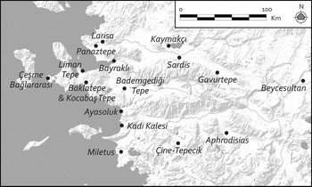
One such citadel is Gavurtepe Höyük, located to the east in the foothills of the Bozdağ range near Alaşehir (Classical Philadelphia). Surveyed and excavated in the late 1980s and early 1990s, contemporary levels at the site are defined by a circuit wall enclosing c. 1.1 ha of protected space, at the peak of which was a large megaron-shaped building (Meriç, Reference Meriç1987, Reference Meriç1989b, Reference Meriç1990, Reference Meriç1992, Reference Meriç1993). In size and organization, Gavurtepe Höyük most closely resembles Kızbacı Tepesi and Koca Dere in the Marmara Lake basin, with their wall circuits enclosing elongated forms partly dictated by natural topography.
A better parallel can be found to the west at Bademgediğı Tepe, located in the lower Küçük Menderes Valley, near Torbalı. As mapped and excavated in the early 2000s, the site is defined by a circuit wall atop a bedrock knoll that encloses c. 2.8 ha (Meriç & Mountjoy, Reference Meriç and Mountjoy2002; Meriç, Reference Meriç, Cobet, von Graeve, Niemeier and Zimmermann2007). Flanking the wall around its interior is a broad terrace, and at the core of the site is another monumental circuit enclosing an oval area at the site's apex. These features best parallel the broad circumferential terraces and circuits around bedrock knolls at Koca Dere, Asar Tepe 2, and Gedevre Tepesi, and the size of the citadel falls comfortably within the range of those in the Marmara Lake basin. Bademgediği Tepe too, with its oval inner circuit, is reminiscent of Gedevre Tepesi and Kaymakçı. Yet, at these sites, the concentric quarter-circle shapes of their inner circuits are so particular that they appear to represent a previously unidentified local building tradition. For additional comparanda, especially for Kaymakçı, one must look further afield.
Only little is known about the configurations of other fortified sites of the second millennium bc in central western Anatolia. Beneath the remains of later periods, limited exposures of a second-millennium bc fortification wall on the acropolis of Pergamon show that it was defined by components similar to those at Kaymakçı and was likely to have served as the primary site of the middle Bakır River valley (Radt, Reference Radt1992; Hertel, Reference Hertel2011). Panaztepe too, in the lower Gediz Valley, appears to have been defined by a fortified citadel, extramural settlement, and cemetery areas; yet post-Bronze Age activities at the site obscure overall site organization (Günel, Reference Günel1999; Erkanal-Öktü, Reference Erkanal-Öktü, Erkanal-Öktü, Günel and Deniz2008; Aykurt, Reference Aykurt2010a; Reference Aykurt2013). The same is true of nearby Larisa and Bayraklı (Bayne, Reference Bayne2000; Hertel, Reference Hertel, Cobet, von Graeve, Niemeier and Zimmerman2007), and even Liman Tepe, on the Bay of İzmir (Erkanal, Reference Erkanal, Erkanal-Öktü, Günel and Deniz2008; Mangaloğlu-Votruba, Reference Mangaloğlu-Votruba2011; Reference Mangaloğlu-Votruba, Stampolidis, Maner and Kopanias2015), where excavations of limited second-millennium remains allow for little more than ceramic comparisons. Further south, Kocabaş Tepe in the Menderes Valley of İzmir (Aykurt, Reference Aykurt2010a, Reference Aykurt2013), Ayasoluk in Selçuk (Büyükkolancı, Reference Büyükkolancı, Cobet, von Graeve, Niemeier and Zimmermann2007, Reference Büyükkolancı, Erkanal-Öktü, Günel and Deniz2008), and Kadı Kalesi south of Kuşadası (Akdeniz, Reference Akdeniz2006) were each probably fortified in the second millennium, but none has been investigated thoroughly to date, rendering comparison nearly impossible. Even Miletus is estimated to have encompassed only 5 ha in the Late Bronze Age; there too more accurate insights are impeded by lack of exposure (Greaves, Reference Greaves2002, Reference Greaves2007; Niemeier, Reference Niemeier and Villing2005). Further inland and south of the Menderes Valley, only Çine-Tepecik (Günel, Reference Günel, Günel and Deniz2008, Reference Günel2010) and Aphrodisias (Joukowsky, Reference Joukowsky1986; Mac Sweeney, Reference Mac Sweeney2010) offer contemporary evidence, and while evidence for Çine-Tepecik is growing thanks to ongoing excavations, still little can be said about its overall site organization.
If one looks outside the central part of western Anatolia, the citadel of Troy VI/VIIa—the best known site in the region and the presumed capital of Wilusa—compares well with the central area of Kaymakçı, although Troy's circuit walls enclose a space less than one-quarter the area, even if its extramural settlement provides a closer parallel (Jablonka, Reference Jablonka, Steadman and McMahon2011; Pavúk & Schubert, Reference Pavúk, Schubert, Pernicka, Rose and Jablonka2014; Rose, Reference Rose2014). As made clear above, the size and internal complexity of Kaymakçı stand out not just from Troy and other western Anatolian citadels, but from its local peers too, suggesting its primacy as a local and broader regional capital. Given the reading of historical geography in Late Bronze Age western Anatolia described above, then, Kaymakçı is a strong candidate for the capital of the Seha River Land.
We know strikingly little about the late fourteenth- and thirteenth-century history of the Seha River Land, and close to nothing for the period before that time. Fragmentary Hittite archives nevertheless make clear that its kings were notoriously flexible in their allegiances, pitting Hittite against Ahhiyawan odds for self-interested purposes at various times. It was presumably to situate the Seha River Land more firmly on the side of Hittite causes that some of its kings appear to have been given broader significance, even intermarrying with Hittite royalty in the mid-thirteenth century (Singer, Reference Singer1983: 216; Hoffner, Reference Hoffner2009: 314).
The state of ceramic chronologies (see Aykurt, Reference Aykurt2010a, Reference Aykurt2013; Pavúk, Reference Pavúk, Stampolidis, Maner and Kopanias2015) and limited nature of excavations make it impossible to determine the relative phasing and development of the citadels in the Marmara Lake basin, whether the smaller sites generally pre- or post-date Kaymakçı, or whether they all developed at the same time, with Kaymakçı eventually surpassing its neighbours through the prominence and success of its leaders, the strategic importance of its location, or other factors. Given the settlement patterns and evidence for the centralization of ceramic production (Luke et al., Reference Luke, Roosevelt, Cobb and Çilingiroğlu2015), however, it seems likely that one centralized authority did indeed come to the fore. Nevertheless, that multiple citadels (and unfortified settlements for that matter) may have co-existed in close proximity is hardly difficult to accept. In the vicinity of capital cities in Mira, the Hittite king Mursili II (re-)fortified several such strongholds following his successful campaigns (Hawkins, Reference Hawkins1998: 14–15). With respect to the suite of citadels in the Marmara Lake basin as a whole, however, parallels in western Anatolia remain unknown to us.
In northern Anatolia, an example can be found in the Classical region of Paphlagonia (Matthews, Reference Matthews2004; Glatz & Matthews, Reference Glatz and Matthews2005), where survey located a network of Late Bronze Age strongholds located along the river Devrez, or Hittite Dahara. However, this network formed not the core of a Bronze Age territory, but a contested frontier zone between Hittite and Kaska territories, with citadels representing the militarized build-up of frontier lands in a region defined by long-term conflict.
To the west, in the core of the Mycenaean Greek world, a similar density of contemporary citadels can be found in and around the Argive Plain, including Mycenae, Tiryns, Midea, and Argos, among other sites. Owing to the finer chronological control of such sites, one can propose models of settlement-pattern development that help explain the regional data (e.g. Wright, Reference Wright, Alcock and Cherry2004, Reference Wright and Shelmerdine2008). Thus, sites around the Argive Plain that may originally have been of similar size and lesser significance became subordinate to Mycenae in later phases. Similar models of development may explain the prominence of Kaymakçı among its peers in central western Anatolia.
Conclusions
The recently discovered suite of sites described above is the only physical evidence of a central western Anatolian kingdom that had been forgotten or was, at least, previously unknown outside historical archives. While the preponderance of evidence currently suggests that this kingdom held sway over the realm known to the Hittites as the Seha River Land in the Late Bronze Age, this identification remains a prevailing theory, subject to confirmation or refutation by new evidence. At present, the composition and location of the network of sites, along the Gediz Valley's natural corridor connecting Aegean and inland Anatolian worlds, matches well the roles known to have been played by Seha River Land kings in negotiating power relationships between Arzawan, Ahhiyawan, and Wilusan interests. Nonetheless—be it the core of the Seha River Land or not—the Marmara Lake basin, as elucidated by its archaeological remains of the second millennium bc, clearly hosted the local communities of a forgotten kingdom.
The archaeological discovery of these communities resulted directly from the diachronic, systematic methodology of CLAS, which gave us an understanding of indigenous settlement structures and regional organization that is more holistic than achieved elsewhere without such methods. Thus, we are able not only to highlight the size and complexity of Kaymakçı—undoubtedly the primary site in the area—but also to understand its situation within a network of at least five smaller citadels and at least five other unfortified settlements, enabling future investigation of the internal dynamics—from citadel to village to farmstead—of western Anatolian kingdoms in the second millennium bc and their local negotiation of political and economic fortunes.
This work is beginning to shed light on broader dynamics within second-millennium bc western Anatolia too, with the identification of ceramic and other material connections to other sites in the region. The citadels of the Marmara Lake basin may have been influenced by Hittite conquest, but they probably also represent local traditions of fortification. The morphological similarities between local citadels and those in nearby areas appear to provide the basic vocabulary for common fortification principles and thus may provide the first evidence for second-millennium (Arzawan?) traditions of fortification spread throughout western Anatolia. Further evidence for such a tradition will have to be sought in ongoing and future research.
In such research, we affirm the importance of diachronic and systematic survey to produce datasets that do not simply engage with but also extend historical evidence, long-privileged in the art of reconstructing historical geography; this will allow us to gain broader perspectives on the distribution of historical communities across peopled landscapes, from citadels to ceramic scatters. We expect that only with such combined analyses of data from survey archaeology and historical geography will we continue to expand, if not also modify, our understanding of historical communities of second-millennium bc western Anatolia.
Acknowledgments
The research presented here was supported by the National Science Foundation (Awards BCS-0649981 and BCS-1261363), National Endowment for the Humanities (Award RZ5155613), American Research Institute in Turkey, Institute for Aegean Prehistory, Vecchiotti Archaeology and Midas-Croesus Funds, and the Karis, Loeb Classical Library, Marion and Jasper Whiting, and Merops Foundations. For permissions and support, we thank the Ministry of Culture and Tourism, Republic of Turkey, and the Manisa Museum of Ethnography and Archaeology, and its former director S. Soyaker. We are also grateful to the 2005–2014 field teams of the Central Lydia Archaeological Survey, Peter Cobb for illustration assistance, the communities of Tekelioğlu and Hacıveliler, and the anonymous reviewers of a previous draft of this article.


 Open access

