Introduction
1. EHLTC Project Area.

The rugged semi-arid landscape surrounding the Tungabhadra River of northern Karnataka (South India) is home to a remarkable and much-studied archaeological record. Much of this research has focused on two periods: the fourtheenth to sixteenth-century Vijayanagara empire (see Reference VergheseVerghese 2000; Reference MichellMichell 1985), and the third to second-millennia BC Neolithic (see Reference SubbaraoSubbarao 1947; Korisettar et al. 2001; Fuller et al. 2007). The papers in this Project Gallery group presentation focus on a period intermediate between these – the first millennium BC and early centuries of the current era: the Late Prehistoric South Indian Iron Age or 'Megalithic' and Early Historic periods.
Here, we provide some general background to the contributions in the http://www.antiquity.ac.uk/ProjGall/southindia/index.html group presentation by introducing the ongoing archaeological project from which most derive.
Late Prehistoric/Early Historic landscapes of the Tungabhadra corridor
The first millennium BC was a time of remarkable change in South India, witnessing the emergence and expansion of new technologies and economic specialisations, intensification of agricultural economies and landscape transformations, expanding long-distance interactions, and the institutionalisation of durable hierarchical relations of social inequality, materialised through elaborate mortuary monuments and associated ritual practices. During this period too, South India came into increasing contact with northern regions of the subcontinent, most dramatically manifested in the appearance of inscriptions of the Mauryan emperor Asoka at several sites in the Tungabhadra region in the mid-third century BC (see Sugandhi). More than 100 years of archaeological research have emphasised the period’s dramatic megalithic mortuary sites (Reference MoortiMoorti 1994; Brubaker). Comparatively less systematic research has sought to understand the cultural dynamics and social, political, economic, and ideological processes underlying the remarkable changes that characterise first millennium BC South India.
Kadebakele: Upper Terrace.

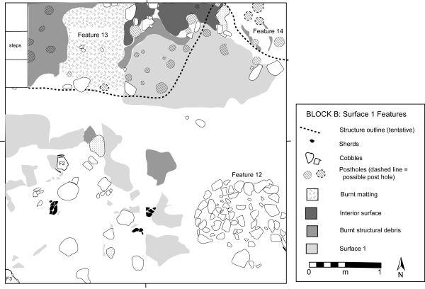
Kadebakele: residential structure.

In 2003, the Late Prehistoric and Early Historic Landscapes of the Tungabhadra Corridor (LP/EHLTC) project was initiated by the Karnataka Directorate of Archaeology and Museums, University of Chicago, and University of Michigan. The project focuses on a 38.5km2 region along the north-east flowing Tungabhadra River, a region best known for the well-preserved remains of the fourteenth to sixteenth-century imperial city of Vijayanagara. Contained within the project region is a dense cluster of Late Prehistoric sites (Map and Figure 1) including mortuary sites, habitation sites, modified landscape features such as rock pools (see http://www.antiquity.ac.uk/ProjGall/bauer/index.html A. Bauer), and numerous rock paintings and petroglyphs. Our research explores the area at multiple spatial scales – from its position within larger pan-South Asian developments to inter- and intra-site variability in production, consumption, and household organisation.
A major focus is the documentation and excavation of settlements in their larger economic and social landscapes. Survey has revealed the remains of four prehistoric settlement sites within the project region as well as several more just outside it. These range in extent from c. 2 to 60+ hectares. Sites VMS-579 (Ramapuram) and VMS-634 (Bukkasagara) have been the focus of detailed surface documentation by http://www.antiquity.ac.uk/ProjGall/johansen/index.html Peter Johansen.
Investigations at Kadebakele
Black and Red Ware ceramic vessel (94.84E -16.93N/Level 14/1).

Carnelian beads from Kadebakele excavations.

Our primary research efforts have been at Kadebakele (VMS-530), the largest settlement in the project area, including surface collections, topographic mapping, and excavations. Kadebakele’s archaeological remains extend over a large area (60+ha), from the river in the south up and over a high (c. 120m high) rugged outcropping hill (Figure 2). Major occupation occurred on several relatively flat terraces (totalling at least 18ha); the hill slopes are also extensively modified, with walls and terraces and dense surface artefact scatters. Our excavations have concentrated on the site’s uppermost terrace, which appears to have been the location of the earliest Late Prehistoric occupation, from c. 900-500 BC. Surface remains suggest that settlement subsequently shifted downslope to the less protected river terrace and continued well into the first millennium.
Excavations in 2003 and 2005 on the upper terrace revealed evidence for settlement and commemorative activities, including the remains of superimposed houses (Figure 3) and stratified middens and stone ‘megalithic’ commemorative features. One of the latter yielded evidence for large-scale communal feasting focused on domestic cattle (see http://www.antiquity.ac.uk/ProjGall/lubauer/index.html R. Bauer). More than a quarter million sherds, predominately of polished black ware, polished red ware, and black and red ware (Figure 4) have been coded and are being analysed to refine ceramic chronologies and assess ceramic use and meaning. A diversity of iron artefacts was recovered in both domestic and commemorative contexts (see http://www.antiquity.ac.uk/ProjGall/gallon/index.html Gallon). Other artefacts include semi-precious stone beads (Figure 5), which provide valuable information on long-distance economic relations and social access to exotic goods among Kadebakele’s occupants.
Acknowledgements
We extend our deepest gratitude to the Archaeological Survey of India, American Institute of Indian Studies, and all EHLTC project participants.