Background
In the southern Levant, major cultural and demographic changes occurred during the Chalcolithic period (45003600 BC). Concomitant with the expansion of villages, horticulture and the secondary products of animals played increasingly important roles in the economy. Craft production exhibited greater technological expertise, materials were procured over long distances, and innovative techniques from stone working to metallurgy developed (see Reference RowanRowan & Golden 2009). Mortuary practices also became more diverse, with a striking increase in status goods. The causes for these dramatic shifts remain obscure, as does the degree of social complexity; some scholars propose the existence of chiefdoms (e.g. Reference Gopher, Tsuk and GopherGopher & Tsuk 1996; Reference Levy and LevyLevy 1995) while others envisage more egalitarian scenarios (e.g. Reference GileadGilead 1988; Reference Joffe and NakhaiJoffe 2003).
The Galilee Prehistory Project
Much of this debate centres on data from excavations at a few sites, primarily in the northern Negev and southern Jordan valley. Unlike those regions, the Chalcolithic in the Galilee is barely known: for example, we have no radiocarbon dates for a settlement of this period, nor do we have an architectural plan. A research initiative of the Oriental Institute at the University of Chicago, the Galilee Prehistory Project, is intended to redress this balance. It aims to understand why this period witnessed transformations such as rapid mortuary diversification, intensification in craft production, and agricultural expansion by examining the relationship between villages and mortuary sites within the region and beyond.
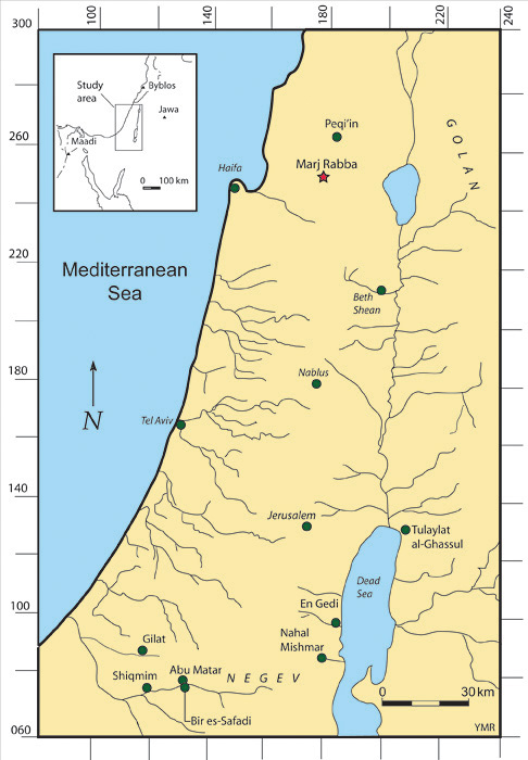
The project's 2009 and 2010 seasons involved limited excavations at the site of Marj Rabba, a Chalcolithic settlement in lower Galilee (Figure 1). They revealed well-preserved walls and other architectural features, with ample faunal, flint and ceramic assemblages. In the third season (2011), geophysical methods were employed in order to determine the full extent of the site and the distribution of archaeological features therein. Our discoveries, using ground penetrating radar (GPR), are presented here; to our knowledge, they represent the first successful GPR survey of a Chalcolithic site in the region.
Map showing Marj Rabba in relation to selected Chalcolithic sites in the region.

Ground Penetrating Radar at Marj Rabba
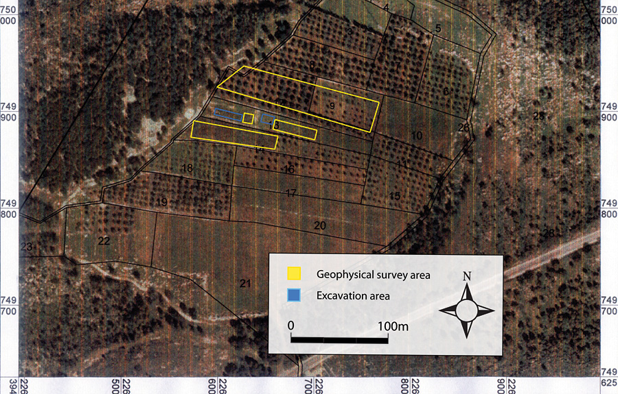
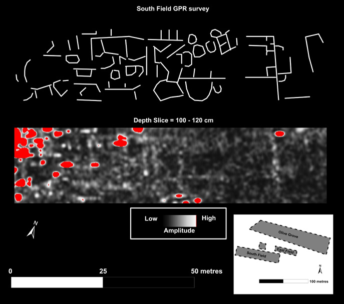
Our survey team faced several challenges, as Marj Rabba is located on active agricultural land (Figure 2). First, the GPR survey required special consideration due to the conductive, rocky substrate (a clay rich terra rossa with embedded stones of varying sizes). Second, the presence of ferrous agricultural debris, much of which was masked by vegetation, interfered with readings where such debris occurred. Third, the northern portion of the site is an active olive grove, which limited GPR surveying to the open rows between olive trees. Despite these challenges, the results of the GPR survey revealed what appear to be architectural features of similar layout to those already excavated on site, though covering a much larger area (Figure 3). These findings expand the known boundaries of the site in three directions, including the olive grove to the north, and fields to the south and east of the excavated areas. The GPR survey, by rapidly expanding the known architectural features of the site from structures spanning about 10 m² to a sizable settlement over at least two hectares, clearly demonstrates the potential importance of geophysical methods in broadening our understanding of the Chalcolithic period in this region.
Image of Marj Rabba showing the GPR survey areas and previous excavations.

An example of ground penetrating radar results at Marj Rabba, showing a portion of the South Field survey at an estimated depth of 100120 cm, along with an interpretation of the feature distribution. Red anomalies appearing on the GPR depth slice represent the strongest responses, many caused by shallow metallic agricultural debris (confirmed with a magnetic survey). Most of these should therefore be considered a type of interference that obscures the features of interest, whose interpretation is drawn above the depth slice.

The Chalcolithic period in the Galilee is slowly emerging. With efforts such as the research at Marj Rabba, much can be learned about this important transitional period in prehistory. Geophysical technologies such as ground penetrating radar can make a major contribution to such efforts by offering a glimpse of what lies concealed, much more rapidly than traditional field methods would allow.
Acknowledgements
Support for this project was provided by the DePaul University Research Council and the Oriental Institute of the University of Chicago. Analysis and writing was supported by the Weidenfeld Research Fellowship. We also thank Max Price of Harvard University for field assistance.