

1. INTRODUCTION
Automatic ship reporting systems have proliferated in recent years, as AIS, LRIT and VMS are being carried by ever more ships. AIS is the Automatic Identification System designed for collision avoidance and globally mandated for carriage on ships of 300 tonnes and up by the UN's International Maritime Organization (IMO). LRIT is the Long Range Identification and Tracking system designed with maritime security in mind, and is also globally mandated for ships of 300 tonnes and up by the IMO. The precise carriage requirements for both systems are rather specific and can be found in IMO Resolutions (SOLAS, 1974). VMS is the Vessel Monitoring System for fisheries control, and its use is dictated by national legislation, and is therefore much less uniform across the world (e.g. FAO, 1998). To participate in one of these systems, a ship carries a transponder on board that automatically sends out short messages (reports) containing the ship's identification, geographic coordinates, time of message, and some more information such as speed and course depending on the system. The transmission repeat interval depends on the system and circumstances, but varies typically between a few seconds for AIS from a fast moving ship to six hours for LRIT.
For AIS, not only carriage but also access to it has been greatly facilitated in recent times, by international AIS exchange networks and satellite-based collection that is often commercially offered. Access to LRIT and VMS remains more tightly controlled by national governments.
The use of satellite communication by these systems and the large amount of AIS data that is available, supplemented by LRIT and VMS data, makes it possible to track ships worldwide and to have a global picture of current ship traffic. Such a picture (global or only covering a more limited area of interest) will be called here a Maritime Situational Picture (MSP). The MSP and its temporal evolution allows authorities to be aware of what is happening at sea, to be alerted to potential illegal activities, risks and threats, and to support planning and decision making in maritime operations (e.g. Greidanus et al., Reference Greidanus, Alvarez, Eriksen, Argentieri, Cokacar, Pesaresi, Falchetti, Nappo, Mazzarella and Alessandrini2013).
The AIS signal is carried by VHF radio frequency, and it can be collected by coastal receivers with a range essentially to the radio horizon which is somewhat further out than the visual horizon (and sometimes much further, depending on signal propagation conditions). A network of such receivers can provide a real-time picture of the coastal ship traffic. However, away from the coast the only routine method of AIS reception is via receivers on satellites. Such satellites are in low orbit, collecting data over the area of interest only during their overpasses. The overpasses may be hours apart depending on the area, the satellite orbits and the number of satellites used. In addition, some delay may be experienced due to downlinking and processing of the satellite data. In order to have a real-time MSP available, the ship positions must be predicted from the last known ones to the present time. Linear prediction (dead reckoning) is the simplest way, and indeed more justified in open sea than near the coast (where real-time coastal AIS can take over).
When creating an MSP over an area of interest in this way, the questions arise: What is the completeness of the picture? What is the accuracy of the ship positions? This paper aims to address these two issues. It does so by analysing ship reporting data from a multitude of sources (coastal AIS, satellite AIS, LRIT) that were collected during two trials: the first during Aug 2011 – Jan 2012 over the Western Indian Ocean (WIO – Figure 1 left), and the second during Oct 2012 – Mar 2013 off West Africa and in the Gulf of Guinea (WAG – Figure 1 right). These trials were part of the PMAR (Piracy, Maritime Awareness and Risks) projects that aimed to explore technical feasibility for maritime awareness for African maritime authorities. Previous studies have looked at temporal update rates of reporting data in these contexts (Eriksen et al., Reference Eriksen, Greidanus, Alvarez, Nappo and Gammieri2014), but did not quantify position errors. One early attempt was published by Posada et al. (Reference Posada, Greidanus, Alvarez, Vespe, Cokacar and Falchetti2011).
Monthly ship density maps computed from satellite AIS messages. Left: Western Indian Ocean during the month Jan 2012 with 2·2 M position messages received from 6 AIS satellites. Right: West Africa/Gulf of Guinea during the month Jan 2013 with 7·7 M messages received from 8 AIS satellites. The colour coding is # messages per 0·1 × 0·1° box in logarithmic scaling.

2. CONSTRUCTING THE MSP
The MSP is a map of the current ship positions in an area of interest, typically overlaid over a background map with coastlines, bathymetry, etc. As the ships are moving, the MSP has to be constantly updated. But because the MSP is computed, for practical reasons it is updated at fixed intervals. For a wide-area MSP, ocean-basin wide as is studied here, an update rate of once per 15 minutes is deemed sufficient. The MSP is computed from ship position reports that can come from a collection of sourcesFootnote 1 – AIS from multiple coastal stations, networks, satellites; LRIT or VMS from multiple governments. The more sources that contribute, the more complete and up-to-date the result can be. The data that are analysed here include: coastal AIS collected by the MSSIS network (US DoT, 2014); satellite AIS from the Norwegian government (NORAIS and AISSat-1) and from the commercial operators exactEarth and ORBCOMM/LuxSpace; and LRIT from most of the Flag States that use the EU LRIT Data Centre (“EUDC Flags”) operated by the European Maritime Safety Agency (EMSA, 2014).
Ships are identified in their messages by their Maritime Mobile Service Identity (MMSI) number (for AIS), their IMO number (for LRIT) or some other form of identification (for VMS). Often, a ship will carry more than one reporting system: e.g., LRIT and AIS for big merchant ships (following IMO regulations), or VMS and AIS for EU fishing vessels down to 15 m length (following EU regulations – EC, 2011). A register is needed to correlate MMSI number, IMO number, etc., in order to avoid multiple introductions of the same ship in the MSP. Such registers are available, but have to be maintained because ships may change their identifications from time to time. Additional information about the ship (such as size, type, cargo, destination) can be received via dedicated messages (AIS, static message type 5, 19, 24 – ITU, 2010, Annex 8; US CG, 2014) or must be retrieved from a ship register. Such information is essential to have available for display in the MSP.
All position messages received from the same ship constitute its reported track. The current ship position is predicted based on its most recent reported position and its speed and course at that time. The latter two can be reported in the ships' message (the case for AIS) or computed from the last and penultimate position reports (as e.g. the LRIT message does not include course and speed).
The reporting data are unfortunately subject to several types of error that can impact on the MSP and its predicted positions. In the first place, individual messages can contain wrong data, such as wrong geographical positions. This leads to single outlier points in the ship's track (that can even lie on land). Such outliers need to be recognised and removed to avoid displaying wrong results. It is also observed that individual ships may transmit consistently wrong details, such as a course that is always 90° away from the actual course (as shown by the ship's motion). In the second place, the same MMSI number can be used (in violation of regulations) by different ships. This occurs especially with MMSI numbers that are invalid to start with. A normal ship's MMSI number needs to have nine digits, the first three being the country code (ITU, 2012; Annex 1); but invalid numbers like 0, 111111111 or 123456789 are also seen, and often used by multiple ships. The tracking needs to disentangle the multiple tracks of such MMSI numbers, and it can do so, to some extent, by recognising jumps in position that would need unrealistic speeds (Falchetti et al., Reference Falchetti, Alvarez, Greidanus, Cokacar and Vespe2012). In the third place, it is found that the times of the AIS messages can have systematic and random errors. The AIS message itself does not contain its time of broadcasting, as AIS was designed as a real-time line-of-sight communication. Therefore, the receiving station (coastal or satellite) attaches a time using its own clock. By comparing AIS messages of the same ship received by different stations, it is found that these external time stamps can be inconsistent due to clock offsets and instabilities. With differences that can be many seconds or even minutes, a speed computed from two consecutive messages that are received by different stations can have very large errors. Methods to deal with that include using only consecutive positions from the same receiving station in computing speed and course, or using two positions not too close in time.
The analysis here only uses the content of the ship reports that is automatic, namely the time, and the latitude, longitude, speed and course that are obtained from the Global Positioning System (GPS). Other content that is available in AIS messages such as port of destination and estimated time of arrival is inserted by hand, and therefore more prone to errors including orthographic/language differences, and it is not considered in this study. The only manually inserted information used is the MMSI number that is assigned to the AIS transponder when it is initialised on the ship. This number may be manually changed again but that only happens infrequently.
When done in a judicious way, the use of multiple data sources can be of great help to detect and suppress errors in the ship position reports. Otherwise, it can easily lead to spurious content in the MSP. However, the errors need to be dealt with automatically in the processing. The total number of position reports received in January 2013 over the WAG area, for example, was more than 11·5 million (see Table 1). A full manual analysis is impossible. Sample manual checks on randomly selected ship tracks have been used in the development and verification of the automatic algorithms.
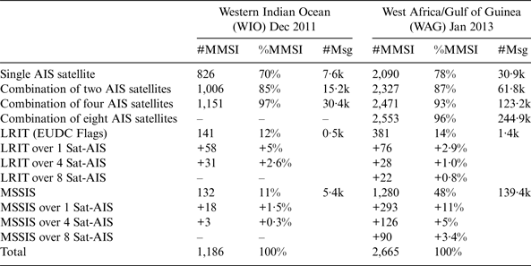
Number of different MMSI (columns #MMSI) seen per day on average for the conditions mentioned in the left column, in the areas/periods mentioned on top. These are derived from the position messages, whose daily average number is quoted in the columns #Msg. The columns %MMSI give the #MMSI as a percentage of the total number of MMSI seen by all sensors together as quoted in the bottom row. “LRIT over N Sat-AIS” means what the combination of LRIT plus N AIS satellites shows more than the combination of N AIS satellites only. Likewise for MSSIS (not shown in graphs).
3. COMPLETENESS OF THE MSP AND THE CONTRIBUTIONS OF THE VARIOUS SOURCES
3.1. Introduction
Clearly, the MSP as discussed here will only contain the ships that are reporting. To detect and track other, non-cooperative, ships, different techniques are needed, such as e.g. coastal radar, airborne infrared camera, satellite imaging, or other observation systems. Using AIS, LRIT and VMS means that one may only expect to see large and medium-sized vessels, some fishing vessels, and some pleasure and other craft that carry the voluntary Class B AIS. With LRIT and VMS being controlled by the ships' Flag States, access depends on regulations or agreements; AIS data is also available on a commercial basis with less regulatory limitations.
Given the above restrictions, still the individual data sources from which the MSP is constructed are all incomplete. This is especially the case for satellite AIS. As AIS was not originally designed to be received from space, only a fraction of the transmitted messages are actually received by a satellite. AIS signals from the voluntary Class B equipment are broadcast with lower power than those of the obligatory Class A, so their detection rate from space is bound to be lowerFootnote 2. But also particular individual ships can be more difficult to detect, because their equipment's transmission power is lower than specified or their AIS antenna is unfavourably placed. And in very busy regions, too many ships may transmit at the same time so that their signals become garbled. Each AIS satellite will therefore never receive all of the messages transmitted in its area of coverage, nor detect 100% of the ships that are transmitting. Coastal AIS has better performance, but its range is much more limited. LRIT and VMS can be expected to be more complete, but even there it is found that a fraction of all messages is never received (e.g. easily recognised as gaps in LRIT six-hourly or VMS two-hourly message series).
3.2. Results
The most complete picture will therefore be obtained by combining as many sources of reporting data as possible. Figures 2 and 3 show how adding more data sources increases the number of ships observed, for satellite AIS and LRIT. In these figures, the nature of the left panel is different to that of the right panel, as the former is cumulative and the latter differential.
The number of different MMSI numbers (different ships) seen per day in position reports during December 2011 over the Western Indian Ocean (the area of Figure 1 left). Left: From four different AIS satellites (NORAIS, AISSat-1, and two exactEarth satellites). Right: The number of different ships seen each day in the LRIT data, over and above those seen in AIS. (On 4 December there was no reception from satellite 5 and on 14 December there was no LRIT reception.)
The left panel in both figures concerns satellite AIS and shows the increase of the number of detected ships with the increase of the number of data sources. The dotted lines show the number of MMSI per day seen in the area of interest for each individual satellite, identified by a number as 4, 5, 6, etc. The solid lines show the average number of MMSI per day when using a single satellite (<1>, i.e. the average of all the dotted lines); the average of a combination of two satellites (<2>, i.e. the average of combining 4 and 5; 4 and 6; 4 and 7; etc.); the average of a combination of three satellites (<3>, i.e. the average of combining 4, 5 and 6; 4, 5 and 7; etc.); up to the number of MMSI per day from the combination of all satellites that were considered in that period (<4> in Figure 2, <8> in Figure 3).
The right panel of the two figures concerns LRIT in comparison with AIS. First it shows as the highest line (red, marked L) the number of ships seen per day on LRIT. The lines below that show the number of ships seen each day exclusively in the LRIT data, over and above those seen in AIS, as LRIT is combined with progressively more AIS satellite data. Red line (L): LRIT data only. Black line (L-<1>): the number of MMSI per day seen extra by adding LRIT to one AIS satellite on average. Blue (L-<2>): the number of MMSI per day seen extra by adding LRIT to the combination of two AIS satellites on average. So the figure shows that even though the number of daily ships seen with LRIT alone fluctuates around 141 (top red line in right panel) and the number of daily ships seen by combining four AIS satellites fluctuates around a much higher 1,151 (top green line in left panel), adding LRIT to those four satellites still adds another daily 31 ships (on average) (bottom green line in right panel). (These numbers are repeated in Table 1.)
Figure 2 was constructed based on position messages only (AIS message types 1, 2, 3, 18, 19, and, in the right panel, LRIT). Although also AIS data from ORBCOMM/LuxSpace satellites were received, in that period the individual satellites were not identified in those data so they could not be used for this analysis. LRIT is only from the ships with Flags that are collected by EMSA's EU LRIT Data Centre.
Figure 3 shows the same kind of analysis, but one year later and off West Africa, and with eight satellites contributing.
From the above analysis, it can be seen that every additional AIS satellite adds to the total number of different ships seen; however the addition is always decreasing with the number of satellites already used. Absolute numbers are listed in Table 1.
3.3 Discussion
From Table 1 it is clearly seen that each additional data source, even if it overlaps with other data sources, still provides new information. By using two AIS satellites instead of one, the number of ships seen (as indicated by the number of different MMSI seen in position messages) increases by 22% (WIO December 2011)/11% (WAG January 2013). But of course the additional value decreases with more sources: using eight instead of seven AIS satellites increases the number of ships seen by only 1% (WAG January 2013). Especially for LRIT it is notable that even though, when added to the data of eight AIS satellites, it represents only 0·6% (1·4k/244·9k) of the number of position messages and covers only EUDC Flags (of the countries that use the EU LRIT Data centre), still it reveals 22 ships that the AIS – that covers all Flags – does not show.
4. TRACKING AND PREDICTION ACCURACY
4.1 Method
The approach to tracking and prediction was outlined above. In order to assess the accuracy of the predicted 15-min-interval MSP positions, one would want to compare them with their true values. However, those are not known. But what is known are the ship positions at the times of the position messages. So in order to measure prediction accuracy, we predict the positions of a ship not at the 15-min MSP times but at the times of its position messages, based always on its earlier position messages. If the available position messages of a certain ship are numbered i (=1..N), then for each i >= 2, the ship's position is predicted using the position, speed and heading at i-1 if all those elements are available in message i-1 (“method A”). Alternatively, for each i >= 3, the ship's position is predicted using its position at i-1 and the speed and course calculated from its positions at i-1 and i-2 (“method B”). The predicted positions can then be compared to the reported positions and the deviations can be measured. See Figure 4. This can be done for all ships in the area of interest and during a certain time interval.
A section of a ship's track, plotting its latitude against time. The black line connects the ship's position messages that are dots colour-coded by the receiving platform. The red dotted line connects all predicted ship positions that coincide in time with the received positions as explained in the text. The vertical offsets of the red line at the coloured dots is the collection of prediction errors (in latitude).
The outcome of this exercise, however, is not yet a good indicator of prediction accuracy, because it is biased to small prediction times. This is because during the overpass of an AIS satellite, which lasts about 15 minutes, many position messages of the same ship can be received at short intervals. This leads to a sampling of the position error measurements on many small intervals followed by one long one until another satellite passes over. This is a very different sampling than the regular 15 min one from the MSPs. To correct for this bias, the measured prediction errors of a certain ship as a function of time are (linearly) re-interpolated to a regular 15 min grid. In reference to Figure 4, this means that the red dotted line is re-sampled at 15 min intervals, instead of being sampled at the irregularly spaced coloured dots that occur in groups. In doing so, as an additional measure, a maximum time for track extrapolation (maximum prediction time) must be chosen: the time after which a linear prediction cannot be assumed applicable anymore. This is the same as the maximum time to continue the ship's inclusion in the MSP after last message reception.
This method of calculating the MSP positions accuracy was applied, with the following implementation details.
• Message data collected over the Western Indian Ocean area between 15 November and 15 December 2011 (31 days) were used, with as data sources six satellites (AISSat-1, NORAIS, two exactEarth and two ORBCOMM/LuxSpace), coastal AIS from MSSIS, and LRIT. All position reports on land (being obvious errors) were removed using a land mask. The resulting data set consisted of 1·5 M position messages containing 5,155 unique MMSI numbers.
• Only ships with valid MMSI numbers were retained (nine digits, valid country code), leading to 5,035 unique MMSI numbers.
For constructing the ship tracks:
• To assess whether the positions of one MMSI actually belong to the same ship, or to multiple tracks because the MMSI number is used by more than one ship (“track disentanglement”), tracks are grown in time by adding consecutive new positions, and a new position is only associated with an existing track if a speed of < =45 knots is indicated. Otherwise, a new track is started. Tracks that finally remain only a single point long are deleted afterward because they are more likely to be due to message errors (nor could they be used to measure a prediction error because at least two points in the track are needed for that).
• To allow for inaccuracies between the timestamps from different AIS sources, the speed that is compared to the 45 knots is calculated adding 180 sec to the time difference. This implies, among other things, that two positions closer than 2·25 NM will always be assigned to the same track.
• Positions that are closer than 10 m and 10 sec are deemed to be identical.
• The MMSI numbers that were used by multiple ships, as concluded from track disentanglement, were discarded. This is to prevent errors in the track disentanglement biasing the estimated prediction error. This led to a remaining total of 4,783 ships.
For making predictions:
• Last known speed (reported or calculated) remained valid for 1·1 day; after that set to 0.
• Maximum allowed speed was 35 knots (so lower than in the track disentanglement); higher speeds were capped to that level.
• Maximum prediction time was 12 hoursFootnote 3.
The final mean MSP position error was calculated by averaging over all the 15 min interpolated predicted ship position errors from all tracks in the area of interest during the entire one month period. An additional measure of accuracy was calculated by counting the fraction of all these position errors that are less than 10 NM.
Tests with the predictions were made using three different methods to obtain the speed and course: (A) always as quoted in the message and 0 when not included in the message; (B) always derived from last and before-last positions; (C) as quoted in the message when available and otherwise according to method B. The last method gave the lowest errors and these will be quoted in the following. It was also tested whether speeds calculated from the two most recent positions gave better results when not allowed to combine different platforms (to prevent cross-platform clock differences). However, with method C, this was not found to lead to much better results, so it was not applied.
4.2 Results
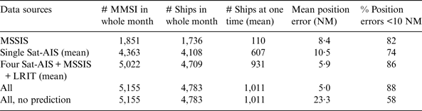
The above procedure, including tracking and prediction, was carried out using all available data sources, but also using only subsets of the data sources, in order to assess the impact of the number of data sources on the final accuracy. The results are summarised in Table 2. In that table, the top line (MSSIS) is using data from the coastal MSSIS AIS network only. The second line (Single Sat-AIS) is the average number when using data from one AIS satellite only. The third line combines data from four AIS satellites – which is the average over three combinations of selecting four AIS satellites from the available six – plus MSSIS plus LRIT (LRIT EUDC Flags only). The fourth line (All) uses data from all six available AIS satellites, MSSIS and LRIT (EUDC Flags). The bottom line uses the same data but without prediction, instead always leaving each ship's position at its most recently reported one. The columns show: the total number of different MMSI seen during the whole month; the total number of ships tracked during the month, reduced from the number of MMSI as explained above; the average number of ships seen at any one time in the MSP, which is much less than the previous number because ships move in and out of the area of interest; the mean position error, averaged over all calculated MSP positions; and finally the percentage of MSP positions over the whole month with an error less than 10 NM.
Numbers of ships and position errors in the MSP, derived from the analysis described in the text in the Western Indian Ocean area for the period 15 November – 15 December 2011.
4.3 Discussion
Considering the accuracy of the ship positions in the MSP, predicted from their latest reported positions, Table 2 shows that an average accuracy of 5 NM, in combination with 88% of the positions being accurate to within 10 NM, can be reached by combining eight different data sources (six AIS satellites, coastal MSSIS and LRIT of EUDC Flags). This average error is in fact dominated by large errors in a small number of ships – those that have a high error rate in their transmissions, and those that move erratically. Most of the ships have smaller errors. These numbers are based on data collected in the end of 2011, so they would be better today as the capacity of satellite AIS has improved. The more usual practice is that the MSP displays the last reported position of each ship, only updating it when a new position comes in which can be of the order of an hour old, leads to an average position error of 23·3 NM and only 58% of the positions being accurate to within 10 NM (bottom line in Table 2), numbers that are much worse than when using prediction. Looking at the accuracy of using only a single data source, one AIS satellite on average leads to a 10·5 NM mean position error; and using only MSSIS leads to 8·4 NM mean position error. The latter number is the smaller of the two, because it refers only to a subset of the ships, namely those that are in coastal range: an MSP using only coastal MSSIS would contain on average 110 ships each moment, whereas an MSP based on the data of only one AIS satellite would contain 607 ships on average at each moment. All these figures refer to the Western Indian Ocean area in November/December 2011 (Figure 1 left).
5. CONCLUSIONS
Automatic ship reporting systems allow the construction of a Maritime Situational Picture (MSP), showing the locations of ships over a wide ocean area in real-time. Of the three generally used systems AIS, LRIT and VMS, AIS produces by far the biggest amount of data and is also the most accessible. The use of AIS receivers on satellites enables a global coverage. However, a small number of the received position reports contain errors, partly introduced by the shipboard equipment and partly introduced upon reception. Many transmissions are not received by satellite due to the weakness of the signal or interference. The MSP is therefore not complete.
In this study, it was shown that a single AIS satellite sees on a daily basis on average only 70–78% of the number of ships that is seen by a combination of a set of AIS satellites, LRIT from EUDC-flagged vessels and coastal AIS; the first number referring to a test area off East Africa in December 2011 where four AIS satellites were available, and the second number referring to a test area off West Africa in January 2013 where eight AIS satellites were available. A combination of two AIS satellites raised the fraction of ships seen to 85–87% (the two numbers again referring to the two test areas), and using the maximum available number of satellites (4 or 8) brought the fraction of ships seen to 97–96%, the remainder being only seen on LRIT or coastal AIS. In particular the LRIT data revealed the presence of 31 or 22 ships not seen by any AIS satellite – the two numbers, as before, on an average daily basis, the first one referring to the East Africa December 2011 test area, and the second one to the West Africa January 2013 test area.
The two test areas cover a similar extent of sea and are at similar latitude, leading to a similar number of potential satellite overpasses. However, the West Africa area shows more than twice the number of ships compared to the East Africa one. This also applies to the number of ships seen using one AIS satellite only, and seen on LRIT. Part of the difference can be attributed to the improvement of the satellite AIS quality from December 2011 (East area) to January 2013 (West area), as witnessed e.g. by the difference in the average daily number of messages per ship seen by a single AIS satellite that increases from 9·2 (ref. Table 1: 7·6k/826) to 14·8 (30·9k/2090). Furthermore, the coastal AIS coverage from MSSIS is much more extensive in the West Africa area. For the rest, the difference can reflect differences in ship traffic; both areas have much tanker and cargo transiting traffic but the West area also has significant local traffic.
Downlinking the data received by satellite to Earth and subsequent processing introduce a latency. This presents the choice of either displaying ‘most recent’ positions for the ships in the MSP, or using an estimation method to predict the ship positions to the present time. ‘Most recent’ positions obviously have an error with respect to the actual position, but also predicted positions have an error, that depends on the latency and on noise in the data. The dominating sources of noise in the data are clock errors of the receivers, MMSI numbers that are shared between different vessels, individual AIS equipment that produces noisy data, and single outlier errors.
This study has estimated the resulting errors in the ship positions that are displayed on the MSP. It is found that showing ‘most recent’ positions using data from four AIS satellites, LRIT from EUDC-Flagged vessels and coastal AIS, leads to an average position error of 23 NM, which is quite large. This is based on a test area off East Africa in November-December 2011. Showing predicted positions in the MSP based on dead reckoning greatly reduces this error, to 5 NM. However, if only a single AIS satellite is used with the prediction, the average position error is only reduced to 10 NM.
Analysing the data in detail has provided much insight in their nature and especially in their errors. For example it is found that certain ships have many more errors in their messages than others, such as speeds/courses that are inconsistent with the ship's actual motion as derived from its positions, or latitude/longitude values that regularly drop digits or signs. The tracking algorithms can be improved to better deal with such cases, avoiding the creation of erroneously positioned targets and improving the positional accuracy in general. Prediction can also be improved by making use of preferred ship routes and traffic patterns, especially when predicting over longer time periods. However, such an improvement is only attained in an overall sense – predictions in this way on individual ships may be far off. These kinds of improvements are currently being tested and are expected to lead to much better MSPs, especially in combination with the increasing capacity of satellite AIS both as regards to quantity and to speed of delivery. Future trials should also include VMS data to further extend the completeness of the MSP.
ACKNOWLEDGMENTS
The Norwegian FFI and the Norwegian Coastal Administration are thanked for providing access to NORAIS and AISSat-1 data. The Maritime Administrations of the Flags that use the EU LRIT Data Centre, EMSA who runs it, and the Italian Coast Guard who were the first are thanked for providing LRIT data. The commercial providers exactEarth, LuxSpace and ORBCOMM are thanked for their service. The Volpe Center of the US Department of Transportation and the US Navy are thanked for access to the MSSIS data. The reviewers are thanked for their comments that have improved the paper.


 Open access