Introduction
Gold was found on the Shotover River in 1862 and it became known in hyperbole as ‘the richest river in the world’. It was first worked by hand methods: panning and rocker boxes. In the later stages, ground sluicing (bringing water to the top and letting it run down the working face), California sluice monitors (a nozzle mounted on a universal joint which directed a massive jet of water on to the working face) and massive bucket dredges, a New Zealand innovation, were all used. Terraces that have been eaten away by the last phase of mining using the California monitors are prominent in the modern landscape.
Landscape areas
The middle and upper Shotover may be treated as a synchronic relict cultural landscape (World Heritage Operational Guidelines 2005). Synchronic means that the origination of the most significant cultural elements of the landscape are all from the one era—goldmining 1861-1914. A landscape area is a terrace unit that is large enough to include supply races, dams/reservoirs, head races, working faces and tail races; and to include their relationship with the Shotover River and surrounding mountains. Dams and water races (leats) generally survive quite well in the modern landscape and are a prominent feature of landscape views. They are a key feature integrating wide areas of goldmining activity. Generally, a landscape unit will be defined at either end by the well formed gullies of the side streams to the Shotover.
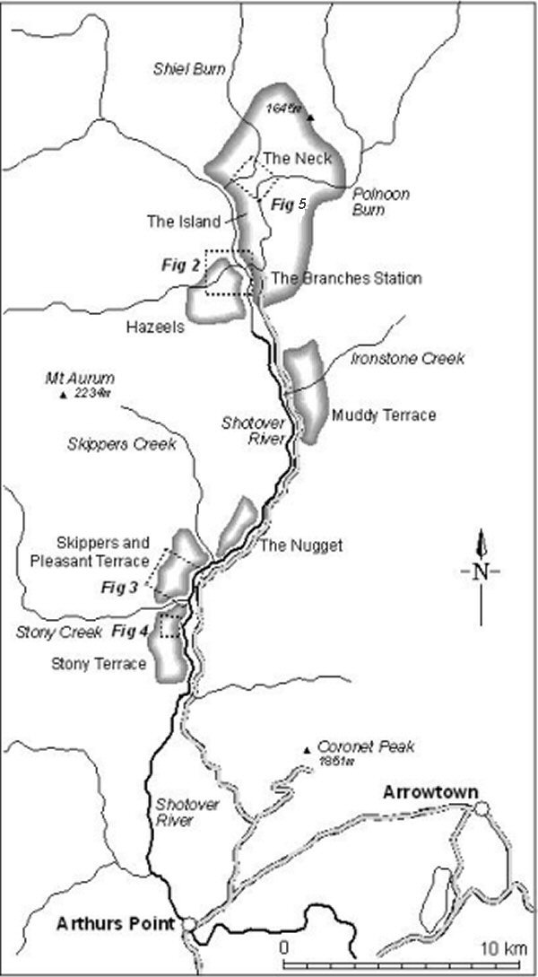
Figure 1 shows cultural landscape areas, from north to south: (1) the nineteenth century pastoral landscape of ‘The Neck’/’The Island’ and the Polnoon Burn (see Figure 5); (2) Hazeels Terrace (see Figure 2); (3) Muddy Terrace and Ironstone Creek (not in figures); (4) the Nugget area (not in figures); (5) Skippers to Pleasant Terrace (see Figure 3) and (6) Stony Terrace (see Figure 4).
Shotover River and landscape areas.

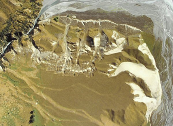
Near-vertical aerial photograph of part of the Hazeels Terrace landscape area, north is at top. Dams are at lower left. The worked area at top results from ground sluicing. The domestic enclosures are on the low narrow terrace by the willow trees, top left.

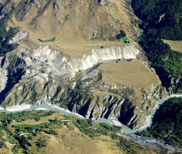
Oblique aerial view of part of the Pleasant Terrace landscape area.

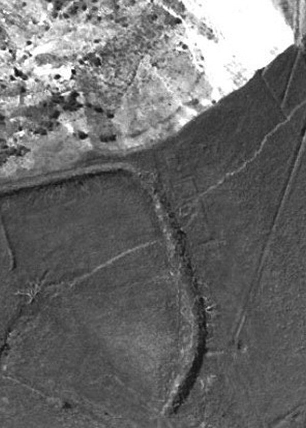
Domestic enclosures on Stony Terrace, showing as low rectangular banks sealed over by the massive curved bank of a later dam, north is at top.

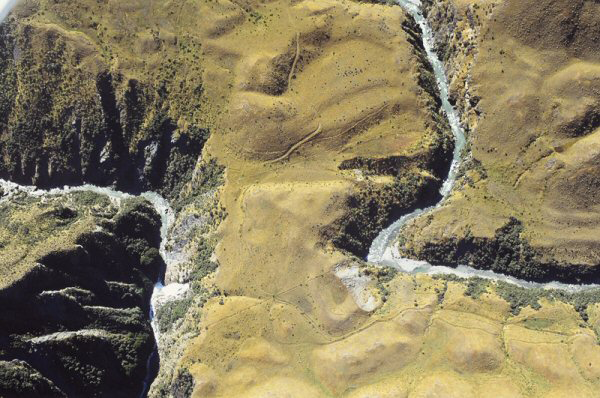
The Neck vicinity. The ditch and bank fence which controlled access to the high country (top) runs between the two burns from top right to bottom left (North is to the left).

Most are alluvial mining areas but the Nugget area is primarily hard rock mining with mines, roads and village sited precariously above a cliff on the Shotover River and a battery at its foot. All six areas have evidence of domestic areas spanning several phases of activity, including rather amorphous sod hut foundations and enclosed yards formed by ditch and bank fences.
The Neck (Figure 5) is unusual: it is an important ‘choke’ point, with steep gorges on either side where stock (sheep) movement to and from high country (up to 1800m above sea level) summer pasturage could be controlled.
Domestic enclosures and the pastoral dimension
The Shotover was entirely pastoral licence or leasehold land. Once gold was known to be there, W.G. Rees, the licence holder in 1863, was told by the provincial land commissioners that he could not ‘do anything which would stop the natural traffic of the country’ (Reference GriffithsGriffiths 1971). The miners exercised substantial rights: to mine, to conduct all the ancillary works (e.g. construct races and dispose of waste gravel). This also included up to one acre for households, subsistence gardens and introducing stock. The aerial archaeology of the Shotover River provides a partial glimpse of this world.
Domestic enclosures were up to the statutory one acre (0.45ha at Muddy Terrace) in area. The small size of the remarkably preserved domestic enclosure at Hazeels appears to have been limited by the small width (13m) of the bottom terrace. The ditch and bank yards excluded stock from domestic and garden areas but some were big enough to have been folds for sheep in winter. Early pastoral yards at Muddy Terrace and a mud-brick house on Stony Terrace were built over by goldmining dams (post 1890?) (Figure 4).
In the course of the survey, I was particularly conscious of the likely age of ditch and bank fences. They went out of use with the introduction of post and wire fences. Today, the upper Shotover is marked by the complete absence of naturally available timber for building material or posts—most likely the result of intensive use of the available native beech during the mining period (1862 to the advent of the First World War). The relatively late Nuggets mining settlement has post and barbed-wire fences (1870s onwards, Reference HamelHamel 2001: 100) and an Art Nouveau (1890-1910?) decorated coal range. Therefore, even allowing for a lag in the take up of post and wire in this remote district, it can reasonably be concluded that the ditch and bank enclosures, which are the main form of enclosure surviving on the Shotover, date to the period between 1860 and 1880. Since these were co-located with mining areas and are all less than the area that could be allocated under a mining licence, it can be deduced that these were in the main miners’ domestic areas and stock or garden enclosures. The one notable example of a pastoral enclosure is The Neck on the Polnoon.
Acknowledgements
Many thanks to Stewart Hardie and the proprietors of The Branches Station. The late Peter Bristow assisted early stages of the project.