Ground stone tools (GST) are found on archaeological sites the world over. However, these tools are all too often lumped into catch-all categories of “other” materials (Schneider Reference Schneider1993:12) with little attention paid to form, composition, or function. In Mesoamerica, traditional analyses of GST have focused on developing typologies to establish temporal shifts in tool morphology (Clark Reference Clark1988; MacNeish et al. Reference MacNeish, Nelken-Terner and Johnson1967; Willey Reference Willey1972). More recently, a few archaeological studies have begun to consider the broader implications of GST and the role(s) these materials played within larger socioeconomic and ritual spheres (Biskowski Reference Biskowski1997; Delu Reference Delu2007; Duffy Reference Duffy2011; Spink Reference Spink1982). These artifacts provide direct evidence of subsistence practices and domestic activities. Additionally, GST studies can reveal much about tool distribution and exchange—and the broader economic, social, and ritual behaviors—that transpired in the past. Yet, these studies have been hampered by a lack of detailed analyses on ancient GST collections and large-scale comparisons of such tools and their distribution across assemblages, sites, and regions. This is largely because there has been—up until now—no sound methodology for chemically sourcing these materials.
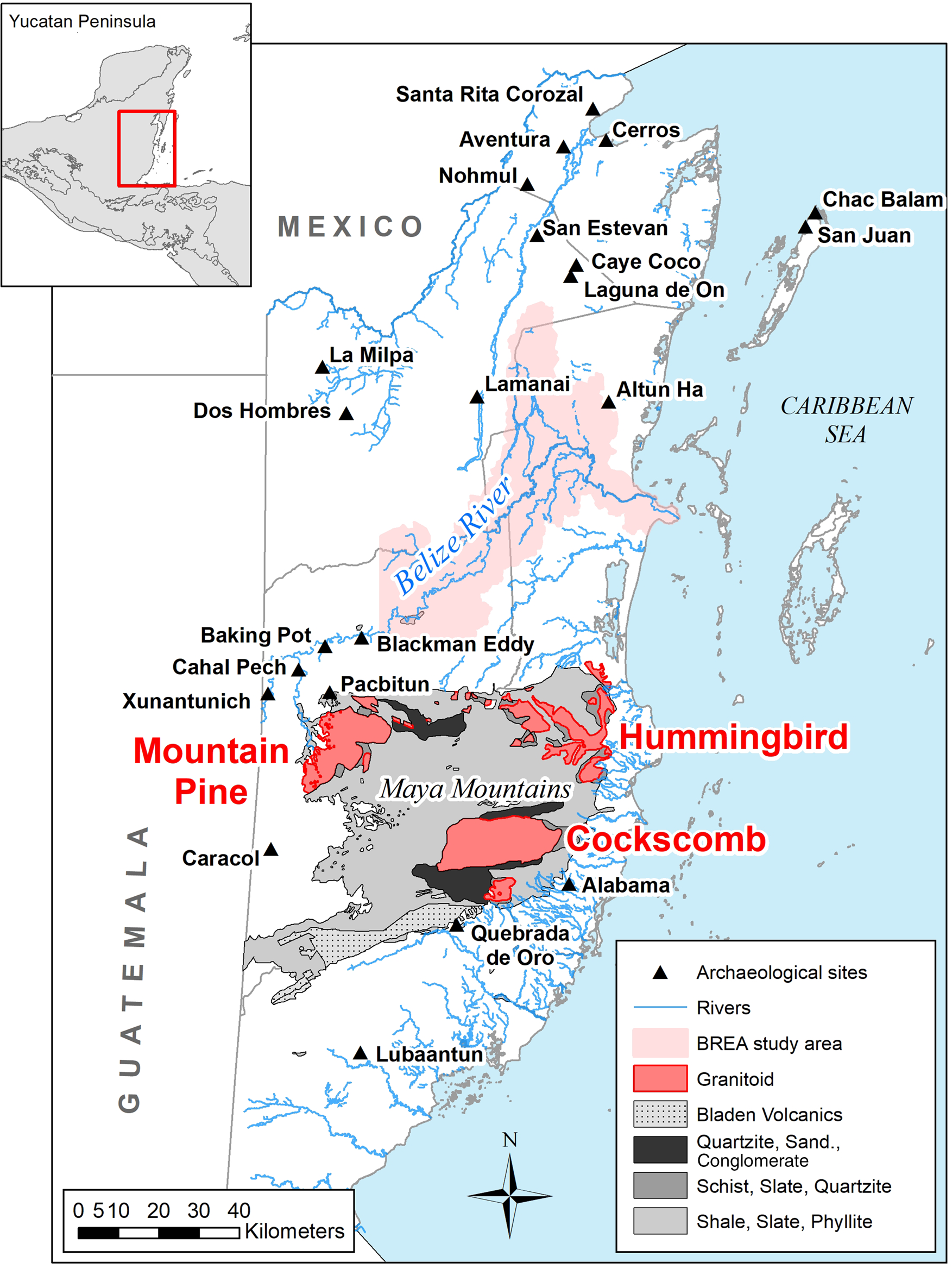
More than 30 years ago, Brian Hayden (Reference Hayden1987) called for more research in this vein, noting that specific rock types—and indeed, individual specimens within those types—were carefully selected by craftspeople for tool design. Why certain stones were chosen over others remains an important key to unlocking “prehistoric culture codes” (Hayden Reference Hayden1987:13). Building on this call, Jenny Adams undertook groundbreaking work in the American Southwest to define forms of manos and metates, conducting experiments to determine which rock types were best suited to specific grinding tasks (Adams Reference Adams1988, Reference Adams1989, Reference Adams1993, Reference Adams2002). Here, we reply to Hayden's call for deeper understandings of why certain stones were chosen over others using a novel methodological application of portable X-ray fluorescence (pXRF) to analyze the geochemical composition of a heterogenous tool stone: granite. In this study, we examine granite outcrops found in Belize, and we use these signatures as benchmarks against which granite GST can be compared. We present results of a chemical study of the granite outcrops from the Maya lowlands of Belize along with a granite GST assemblage from sites in the study area of the Belize River East Archaeology (BREA) Project (Figure 1).
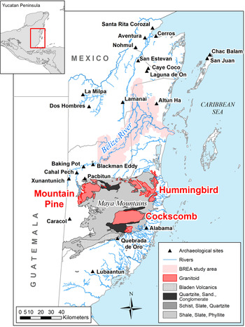
Overview of Belize indicating Maya Mountains and granite plutons, BREA Project study area, and sites mentioned in text. White area in Belize denotes sedimentary bedrock (e.g., limestone, conglomerates, sandstone, shale).
For the BREA assemblage, we can identify macroscale patterns of granite GST provenance and distribution, which is especially intriguing considering that the study area is devoid of granite bedrock or outcrops—the nearest granite sources are located approximately 30–60 km to the south (linear distance). Furthermore, no GST production evidence (e.g., chips, debitage, preforms, blanks, errors) has been recovered by the BREA Project to indicate that GST were shaped at any of our excavated sites; it appears that much of the GST arrived in the area fully formed (see discussion below). Some specimens in the assemblage have been found in secure stratigraphic contexts via excavation, whereas others have been surface collected in disturbed agricultural fields. Therefore, although we can discuss distribution patterns across space, we are more limited in what we can say about temporal patterns with the current assemblage. Below, we demonstrate how this novel sourcing application can be applied more broadly to further explore the complex systems of distribution and exchange in the movement of GST across the Maya lowlands.
BACKGROUND
Like many other ancient societies, the Maya produced a range of GST out of a variety of stone intended for crushing and pulverizing various comestible and noncomestible substances. These tools ranged in morphology and function, from manos and metates, mortars and pestles, pitted and cupped stones, grinding slabs, lapstones, and palettes to other flat surfaces for washing, pounding, and husking (Hayden Reference Hayden1987). GST such as these were used to process maize and other food items such as beans, cacao, chiles, seeds, squash, and tomatoes, as well as nonfood substances such as lime, paint pigments, and tempers for ceramic production (Delu Reference Delu2007:3; Searcy Reference Searcy2011:5). Several ethnographic and ethnoarchaeological studies have investigated regional and local production of GST; patterns of acquisition, trade, and exchange; and the deeper social, political, and ideological meanings of these tools in Mesoamerica (Cook Reference Cook1982; Dary and Esquivel Reference Dary and Esquivel1991; García Chavez Reference García Chavez, Montes and Zúñiga2002; Hayden Reference Hayden1987; Searcy Reference Searcy2011). This corpus of previous work has been instructive for our purposes by furnishing ethnographic information on the processes by which raw stone is selected and designed as GST, and subsequently distributed, consumed, and discarded.
There has, however, been comparatively less theorizing about the processes of production and consumption of ancient assemblages—or indeed, the deeper multivalent meanings of GST—in part due to the absence of a sound method for sourcing these materials chemically. Our aim here is to describe such a technique and show how it can provide baseline provenance information for ancient GST—a first step in unraveling local and regional communication, trade, and exchange connections. We focus on the near ubiquitous stone tool set known as the mano (handheld grinder) and accompanying metate (bottom “netherstone” on which substances are altered; Adams Reference Adams1996; Reference Adams2002:98). We use the term GST (ground stone tool) as a means of referring to both tool types. Although traditionally the terms “mano” and “metate” are reserved for tools used specifically for food processing, we recognize the possibility that these GST may have been used for multiple substances or reserved for specific substances. Moreover, the range of contexts in which GST are found—from households to burials—indicates multiple uses for these materials beyond simply a utilitarian function.
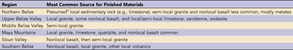
Precontact Mesoamerican GST were made of a variety of igneous, metamorphic, and sedimentary rock. In the Maya lowlands of Belize, ancient manos and metates were fashioned out of igneous basalt (vesicular and nonvesicular) from the Guatemalan highlands and granite from the Maya Mountains, as well as from other sedimentary rock (e.g., limestone, sandstone, slate, and quartzite [Graham Reference Graham1987; Hayden Reference Hayden1987; Sidrys and Andresen Reference Sidrys, Andresen, Hester and Hammond1976; Spink Reference Spink1982; Table 1; see also Supplemental Table 1 for a list of regional site reports and publications]). Given that this study is situated predominantly in the Middle Belize Valley, we use the terms “nonlocal” to describe basalt (nearest outcrops are more than 300 km west and south); “semi-local” for granite (nearest outcrops vary in distance from 30 to 60 km); and “local” for sedimentary types that are available in the BREA study area. As a caveat, although we assume that most limestone was quarried locally on account of its abundance in northern and central Belize, we cannot discount the possibility that limestone may also have been imported from elsewhere. However, applications for limestone sourcing have not been applied to archaeological specimens from Mesoamerica (but see Barbera et al. [Reference Barbera, Barone, Crupi, Longo, Majolino, Mazzoleni and Venuti2013] and Hopkinson et al. [Reference Hopkinson, Rutt, Kristova, Blows and Firth2015] for examples from Europe). Metamorphic rocks are not considered in this survey because they are generally unsuitable for grinding maize due to their high mica content, which would lead to an increased tendency to flake off into the substance being ground.
Overview of Most Common Stone Sources for Ground Stone Tools (GST) in Regions of Belize.

Note: See Supplemental Table 1 for citations.
aSedimentary tool stone from northern Belize has not been tested, so it is presumed to be local.
Manos and metates are often designed as matched sets, with the mano fitting the precise dimensions of the metate depression (Adams Reference Adams1999; Cook Reference Cook1982; Hayden Reference Hayden1987; Searcy Reference Searcy2011). However, the archaeological record reveals that these GST are frequently fashioned out of different raw material of varying origin. For example, at Caye Coco located in northern Belize, Delu (Reference Delu2007:70) observed that “metates were most likely manufactured at distant location [sic] for exchange, whereas manos are not . . . this may also be a result of the desire to not waste more valuable non-local material on manos since manos have a quicker rate of attrition in comparison to metates.” At nearby San Estevan, metates were often made of nonlocal igneous materials, whereas manos were of soft, locally available sedimentary limestone (Levi Reference Levi1993). Consequently, although many GST were probably fashioned out of the same material during initial production, it appears that because manos wear out and break more regularly than metates (Hayden Reference Hayden1987), we are likely to see many more mano fragments in the archaeological record, and some of these will be fashioned on expedient—and possibly softer—local materials to facilitate continued use of longer-lived metates made of higher-quality stone.
The Geologic Setting
Although basalt and granite are commonly used by Indigenous Maya communities for GST production in the ethnographic record (Cook Reference Cook1982; Hayden Reference Hayden1987; Horsfall Reference Horsfall and Hayden1987; Searcy Reference Searcy2011), the lack of local basalt outcrops in the Maya lowlands suggests that granite—a hard igneous rock available in the semi-local sphere—would have been the preferred choice for GST design. This is reflected in the BREA GST assemblage, which contains no basalt (see Supplemental Table 1). Three geographically restricted plutons of granite underlie portions of the Maya Mountains in Belize (Dixon Reference Dixon1956; Figure 1): the Cockscomb Basin (Cockscomb), the Hummingbird Ridge (Hummingbird), and the Mountain Pine Ridge (Mountain Pine). Although the age and tectonic history of the plutons in the Maya Mountains is still under debate (e.g., Bateson and Hall Reference Bateson and Hall1977; Dixon Reference Dixon1956; Jackson et al. Reference Jackson, Duke, Scott, Smith and Wilkinson1995), recent geologic dating indicates that the granite was emplaced during the Late Silurian to Early Devonian (~426–359 mya). The results of this dating work posit that the Cockscomb cooled first, the Hummingbird next, and the Mountain Pine most recently. It is this sequence of magmatic differentiation that provides the basis for the variations within their geochemistries.
The Mountain Pine pluton is located approximately 30 km south of the Belize River and roughly 10–15 km east of the Belize-Guatemala border. This pluton consists of granite, granodiorite, and tonalite (Jackson et al. Reference Jackson, Duke, Scott, Smith and Wilkinson1995). Mountain Pine granite contains lower proportions of mica than granite from the other plutons. Some specimens appear pinkish in color because of large crystals of potassium feldspar. Farther east at the same latitude lies the Hummingbird pluton, a scattered outcrop ranging from granite to granodiorite. Hummingbird granite ranges optically from white to grayish with small black biotite mica crystals. Cockscomb granite—which is visually indistinguishable from Hummingbird granite—is located approximately 20–25 km southwest of the Hummingbird pluton and is the least studied on account of accessibility: it is swathed in dense jungle and is home to a large jaguar preserve. Although samples were taken from the Cockscomb pluton directly by one of the authors, the area cannot be accessed by roads. Consequently, outwash samples from stream and riverbeds close to navigable roadways and settlements also comprised an important comparative source of stone for this study.
Raw Material Provenance in the Belizean Prehistoric Record
To situate this study, we provide a brief overview of the GST archaeological assemblage for Belize constructed from published articles, syntheses, and reports from the region. It is important to note that these assemblage distributions derive from a range of time periods and these temporal overlaps may certainly be related to variations in raw material sources. In other words, we underscore the distinct possibility that source distributions are potentially both geographically and temporally sensitive. Although we lack sufficient data at this time to understand the dynamics of these factors, we hope that the novel application of pXRF to granite presented here will help to illuminate these relationships in future.
In general, many GST consist of local sedimentary rock such as limestone in northern Belize, as seen in the assemblages from Altun Ha (Abramiuk and Meurer Reference Abramiuk and Meurer2006), Aventura (Sidrys and Andresen Reference Sidrys, Andresen, Hester and Hammond1976); Chac Balam (Garber Reference Garber, Guderjan and Garber1995; Guderjan Reference Guderjan, Guderjan and Garber1995), K'axob (McAnany and Ebersole Reference McAnany, Ebersole and McAnany2004), Lamanai (Tibbits Reference Tibbits2016:86; although basalt and granite were also present in significant proportions), La Milpa and Dos Hombres (Tibbits Reference Tibbits2016:84), Nohmul (Abramiuk and Meurer Reference Abramiuk and Meurer2006), San Estevan (Levi Reference Levi1993; sandstone, basalt, and granite also present in significant portions), San Juan (Garber Reference Garber, Guderjan and Garber1995:116; Guderjan Reference Guderjan, Guderjan and Garber1995), and Santa Rita Corozal (Duffy Reference Duffy2011; Jaeger et al. Reference Jaeger, Chase, Chase, Chase and Chase1988). This accords with the sedimentary nature of the area's geologic deposits (Dixon Reference Dixon1956). The site of Cerros presents the most interesting point of departure from this trend in northern Belize, because the majority of metates were composed of metamorphic quartzite (71.4% of the assemblage; likely derived from the Maya Mountains), whereas manos were produced with quartzite and limestone in even proportions (45.0% and 46.6%, respectively; Garber Reference Garber and Freidel1989:18).
In the Upper Belize Valley, GST from sites such as Baking Pot, Blackman Eddy, Cahal Pech, Pacbitun, and Xunantunich are mostly granitic with some other materials as well (basalt, limestone, sandstone, etc.), although the distribution and timing of the influx of nonlocal materials is not well understood (Abramiuk and Meurer Reference Abramiuk and Meurer2006:348). It seems that the proximity of Upper Belize Valley sites to the Maya Mountains—and the Mountain Pine granite source in particular—influenced the type of stone material used in GST production in this area. For instance, just outside the site of Pacbitun at the Tzib Group, 78 granite mano fragments (estimated MNI of 34), 67 granite metate fragments (estimated MNI of 5), and nearly 1,500 kg of granite debitage constitute strong evidence for a GST workshop (Skaggs et al. Reference Skaggs, Micheletti, Lawrence, Cartagena, Powis, Powis, Skaggs and Micheletti2020:167–168; Ward Reference Ward2013). On the other hand, the GST assemblage from Caracol, located farther to the south, suggests that a wider range of stone materials (e.g., granite, basalt, limestone, quartzite) were used in the design of GST, although admittedly, mention of GST in these reports is sporadic (see Supplemental Table 1).
Sites from the east-central Sibun Valley—extending all the way from the Hummingbird pluton of the Maya Mountains northeast to the mouth of the Sibun River where it drains into the Caribbean Sea—display a different pattern from sites from northern or western Belize. At these sites, vesicular basalt comprises 43% of the GST assemblage, and only 21.6% are granitic (Thibodeau Reference Thibodeau, McAnany, Eleanor and Steven2004:243, Table 17.1). Similarly, at the southern Belizean site of Lubaantun, GST are mostly composed of vesicular basalt (Abramiuk and Meurer Reference Abramiuk and Meurer2006:347). Other island and coastal sites also display similar trends, which Abramiuk and Meurer (Reference Abramiuk and Meurer2006:347) suggest is “evidence that vesicular basalt was moving northeast along the southern coast of the Yucatan peninsula from the Maya highlands.” The inhabitants of Alabama, located approximately 20 km from the coast, sourced almost all GST from the adjacent Cockscomb pluton (Peuramaki-Brown Reference Peuramaki-Brown2016). It appears that, very generally, proximity to the granite-rich Maya Mountains was directly related to higher proportions of granitic GST in assemblages. Conversely, sites located farther from the Maya Mountains in northern and southern Belize have markedly decreased proportions of granitic GST.
Another notable volcanoclastic outcrop exists in the Maya Mountains: the Bladen Group, the result of early volcanic activity (most likely Devonian in age; 418–400 mya; Figure 1). This deposit is characterized as rhyolitic to andesitic in composition, with some welded tuffs present (Cornec Reference Cornec2010). Although these volcanoclastic materials were not widely exploited for GST production, some ancient communities (e.g., Ek Xux, Muklebal Tzul, and Quebrada de Oro) situated proximate to this outcrop did make use of them and exchanged them within a restricted local sphere (Abramiuk and Meurer Reference Abramiuk and Meurer2006; for description of some andesite artifacts at Pacbitun, see Skaggs et al. Reference Skaggs, Micheletti, Lawrence, Cartagena, Powis, Powis, Skaggs and Micheletti2020; Tibbits Reference Tibbits and Powis2015b).
Studies of GST from sites in northern Belize have traditionally employed visual inspection of raw materials, providing source assignments that are tentative at best. Without geochemical sourcing, scholars have been cautious about making assertions regarding fluctuating temporal distributions of GST in Belize, but some hypotheses have been put forward. Local geologic sources (local sedimentary rock including limestone, sandstone, conglomerates, and shale) dominate metate production in northern Belize from contexts thought to date anywhere from AD 0 to AD 1250, and some have suggested that there is a marked increase in nonlocal volcanic sources (i.e., basalt, vesicular lava, and pumiceous/andesitic tuff) during the latter half of the Postclassic period (ca. AD 1250–1450; Sidrys and Andresen Reference Sidrys, Andresen, Hester and Hammond1976:181–186, Table 1; see also Sidrys Reference Sidrys1981). This conclusion was provisionally supported by Jaeger and colleagues (Reference Jaeger, Chase, Chase, Chase and Chase1988:107), who analyzed GST from the site of Santa Rita Corozal in northern Belize and reported an increase in nonlocal volcanic stone from the Classic to Postclassic transition. Work by Delu (Reference Delu2007:2) also indicates a provisional shift in the Postclassic toward nonlocal GST, which she suggests may be the result of increased participation in a long-distance system of commerce during this time. GST from Caye Coco in northern Belize (dated to the Postclassic via ceramic typology; Masson Reference Masson1999:289–290) revealed an increase in nonlocal basalt metates; however, at the nearby site of Laguna de On (in contexts dated to the Postclassic by AMS techniques; Stafford Reference Stafford and Masson1999:2–4), Delu (Reference Delu2007:26) found that most of the GST was made from local stone (i.e., limestone and sandstone).
What is clear from this brief review is that to accurately trace any spatial or temporal fluctuations in GST sourcing requires (a) a reliable geochemical characterization technique that can clarify the source of different types of GST and (b) a robust radiocarbon sequence to accurately anchor these changes in raw stone procurement and distribution. The aim of the present study is to address the former concern by describing a novel methodological application of pXRF analysis that can be used to source coarse-grained, heterogenous granite, providing new insights into patterns of distribution and exchange of this important GST material found at sites across the Maya region.
MATERIALS AND METHODS
To begin building a robust framework for exploring GST procurement, design, distribution, and exchange at multiple scales, it is necessary to move beyond visual inspection of granite, given that this raw material varies in color, phenocryst size, and mineralogical composition—attribute combinations that cannot be readily detected by the naked eye. What is needed is the geochemical characterization of both the source outcrop material and the artifacts to obtain accurate provenance data. Such analyses have been carried out widely on artifacts such as obsidian to support complex models of trade and exchange throughout Mesoamerica by matching petrographic fingerprints between artifacts and their geologic source (e.g., Carballo et al. Reference Carballo, Carballo and Neff2007; Hammond et al. Reference Hammond, Nievens, Harbottle and Norman1984; Healy et al. Reference Healy, McKillop and Walsh1984; Moholy-Nagy et al. Reference Moholy-Nagy, Meierhoff, Golitko and Kestle2013). Most of these provenance studies rely on elemental analysis, such as neutron activation analysis (NAA), inductively coupled plasma-mass spectrometry (ICP-MS), lab-based X-ray fluorescence (XRF), and portable X-ray fluorescence (pXRF). pXRF is attractive for analyzing the chemical composition of artifacts because it is expedient, nondestructive, and portable. Furthermore, maintenance and supply costs are low, although the initial cost of the instrument is pricey. Recent technological advances in pXRF have promoted wider testing of archaeological materials in situ or in the field/museum/country of origin, and they have refined statistical analyses for calibration as well as trace element criteria for geographically restricted stone outcrops. Although the technique has shown to be effective in sourcing homogenous materials such as obsidian (Frahm Reference Frahm2012, Reference Frahm2013a, Reference Frahm2013b; Lopez-García et al. Reference Lopez-García, Argote and Beirnaert2019; Nazaroff et al. Reference Nazaroff, Prufer and Drake2010) and basalt (e.g., Palumbo et al. Reference Palumbo, Golitko, Christensen and Tietzer2015; Steiner et al. Reference Steiner, Conrey and Wolff2017), little research has focused on applying this powerful instrument to heterogenous or coarse-grained lithic materials such as granite.
The reluctance to apply pXRF more widely is due to some important methodological challenges related to the comparative newness of the technology (e.g., Barbera et al. Reference Barbera, Barone, Crupi, Longo, Majolino, Mazzoleni and Venuti2013; Craig et al. Reference Craig, Speakman, Popelka-Filcoff, Glascock, David Robertson, Steven Shackley and Aldenderfer2007; Forster and Grave Reference Forster and Grave2013; Frahm Reference Frahm2012, Reference Frahm2013b; Glascock Reference Glascock and Shackley2011; Shackley Reference Shackley2011; Shugar and Mass Reference Shugar and Mass2013). Some of the main concerns of pXRF involve reliability of the instrument and validity of the chemical measurements (Conrey et al. Reference Conrey, Goodman-Elgar, Bettencourt, Seyfarth, Van Hoose and Wolff2014; Nazaroff et al. Reference Nazaroff, Prufer and Drake2010; Speakman and Shackley Reference Speakman and Shackley2013). Brand and Brand (Reference Brand and Brand2014:125) underscore that pXRF instruments “are effective tools to provide ‘fit for purpose’ qualitative chemical data that are precise but typically very inaccurate,” and follow up by stating that “to significantly improve the quality and value of the pXRF data, a calibration procedure appropriate to the material(s) being evaluated should be implemented with regular baseline data collected to ensure instrument and data stability.” However, as the technology has been refined, issues with accuracy, calibration, and instrument drift have been addressed by manufacturers in many of the models used in archaeology (Frahm Reference Frahm2014; Goodale et al. Reference Goodale, Bailey, Jones, Prescott, Scholz, Stagliano and Lewis2012).
Another methodological concern of pXRF is that the technique uses a beam diameter of 10 mm and is therefore more successful with materials that have a homogeneous structure or smaller grain size. In coarser rock such as granite, where phenocrysts can reach and exceed 10 mm in diameter, the ability of the instrument to obtain representative readings becomes a concern because the beam may be smaller than a single crystal in the geologic matrix. This means that the instrument may only obtain the chemical signature of one individual mineral grain, yielding a reading that is far too narrow. Below, we describe a multishot pXRF methodology developed to mitigate these issues by generating bulk geochemical signatures for granite (for details, see Tibbits Reference Tibbits2016).
We began by establishing a baseline geochemical signature range for the three Maya Mountain granitic plutons that outcrop in Belize (i.e., Mountain Pine, Hummingbird, and Cockscomb; Figure 1). Each pluton is separated by roughly 25–35 km. They are petrographically distinct but cannot be reliably distinguished from one another visually. Outcrop samples were collected from both in situ locations as well as riverways where opportunistic collection by the Maya may have occurred (Graham Reference Graham1987:754). A side-by-side analysis was undertaken in which the results of multishot pXRF on whole-rock outcrop samples were compared to those from the same rocks that had been crushed, powdered, and analyzed by pXRF at the University of Iowa, and by traditional lab-based XRF conducted at the Illinois Geological Survey Laboratory. The sample set of whole rock consisted of 19 outcrop pieces from Mountain Pine, 19 from Hummingbird, and 10 from Cockscomb (the smaller sample for Cockscomb is related to its inaccessibility). The whole-rock pXRF analysis was statistically indistinguishable from the lab-based XRF results, which would presumably be the most accurate because it was a homogenized sample and the methodology is considered well constrained (Supplemental Figure 1; Supplemental Table 3 and Supplemental Table 4). Petrographic thin sections were also constructed for optical mineralogical study to confirm that the plutons are in fact petrographically distinct (Supplemental Table 2).
A Monte Carlo simulation allowed for direct comparison of the averaged whole-rock results to the results of the powdered rock. This simulation found that a minimum of five randomly selected data points taken on flat surfaces for each whole-rock outcrop sample were necessary to generate an averaged geochemical signature for pXRF that is statistically indistinguishable from that of a lab-based, powdered sample. The Monte Carlo simulation was cross-examined by selecting five random points for pXRF analysis on a whole-rock outcrop sample. This sample was then powdered and reanalyzed by pXRF and by lab-based XRF. Multiple statistical tests (Pearson's correlation and Spearman's rho) confirmed the correlation between the whole-rock (five data points on average) and powdered readings (Supplemental Figure 2). Once the above pXRF method was shown to be viable, it was applied to archaeological materials using no fewer than five randomly selected data points per artifact. No artifacts were physically compromised in this process.
The instrument used in this study was a handheld Olympus DELTA pXRF with a 10 mm beam diameter. The unit was set to Geochem mode, which has a detection range from magnesium to uranium, and activates two energy beams (10 keV, 30 keV) for 30 seconds per sample. Reference standards were tested prior to any analysis of either outcrop or artifact materials to assess concerns of instrument drift, accuracy, and precision. No drift was detected, and the accuracy and the precision of the unit were both found to be sufficient to consider the data quantitative (Supplemental Figure 3). Regarding pXRF equipment calibration, we found that there was no need to develop a correlation coefficient because the internal calibration that comes standard in the Olympus DELTA instrument was found to be accurate and precise. Specifically, the raw data taken via pXRF on powdered samples from known geologic samples exactly matched the curves produced via lab-based XRF on powdered samples by the Illinois Geological Survey Laboratory. Additionally, our pXRF-derived curves duplicated those published on Geo-ReM, an open-source database containing geologic reference materials (Supplemental Table 3).
Application to BREA Granite Artifacts
The three, tightly restricted outcrops of granite in the Maya Mountains make Belize an ideal location to test chemical sourcing studies of a nonhomogeneous material such as granite. One area where this novel methodology has been applied is in the Belize River East Archaeology (BREA) study area, which encompasses the lower half of the Belize River watershed. The BREA Project has been carrying out field-based research within the study area since 2011 (Figure 2). Over the course of a decade, the project has documented 2,000+ ancient Maya mounded structures and approximately 100 settlements, most previously undocumented (Harrison-Buck Reference Harrison-Buck2011, Reference Harrison-Buck2013, Reference Harrison-Buck2015, Reference Harrison-Buck2018, Reference Harrison-Buck2020). Prior to the beginning of the BREA Project, this stretch of the Belize River watershed was considered a hinterland largely devoid of settlement and social development (Chase and Garber Reference Chase, Garber and Garber2004:3). However, our research indicates that the area functioned instead not only as an important breadbasket suppling agricultural resources to the north and west but also as a critical conduit of trade and exchange of people, goods, and ideas between the Caribbean Sea and the Upper Belize Valley (Brouwer Burg et al. Reference Brouwer Burg, Runggaldier and Harrison-Buck2014, Reference Brouwer Burg, Runggaldier and Harrison-Buck2015, Reference Brouwer Burg, Runggaldier and Harrison-Buck2016; Harrison-Buck Reference Harrison-Buck2010; Harrison-Buck et al. Reference Harrison-Buck, Murata and Kaeding2012, Reference Harrison-Buck, Burg, Willis, Walker, Murata, Houk and Runggalider2015, Reference Harrison-Buck, Burg, Murata, Robinson, Kaeding and Gantos2016, Reference Harrison-Buck, Willis, Walker, Murata, Burg, Houk, Arroyo and Powis2020). As noted above, the BREA area is devoid of granite bedrock, and to date, no archaeological evidence of granite GST workshops has been documented within the project area.
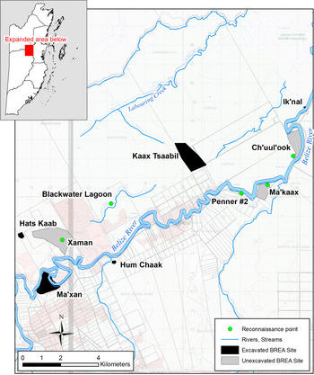
Reconnaissance points, excavated sites, and unexcavated sites in BREA study area from which granite ground stone tools (GST) were derived for this study.
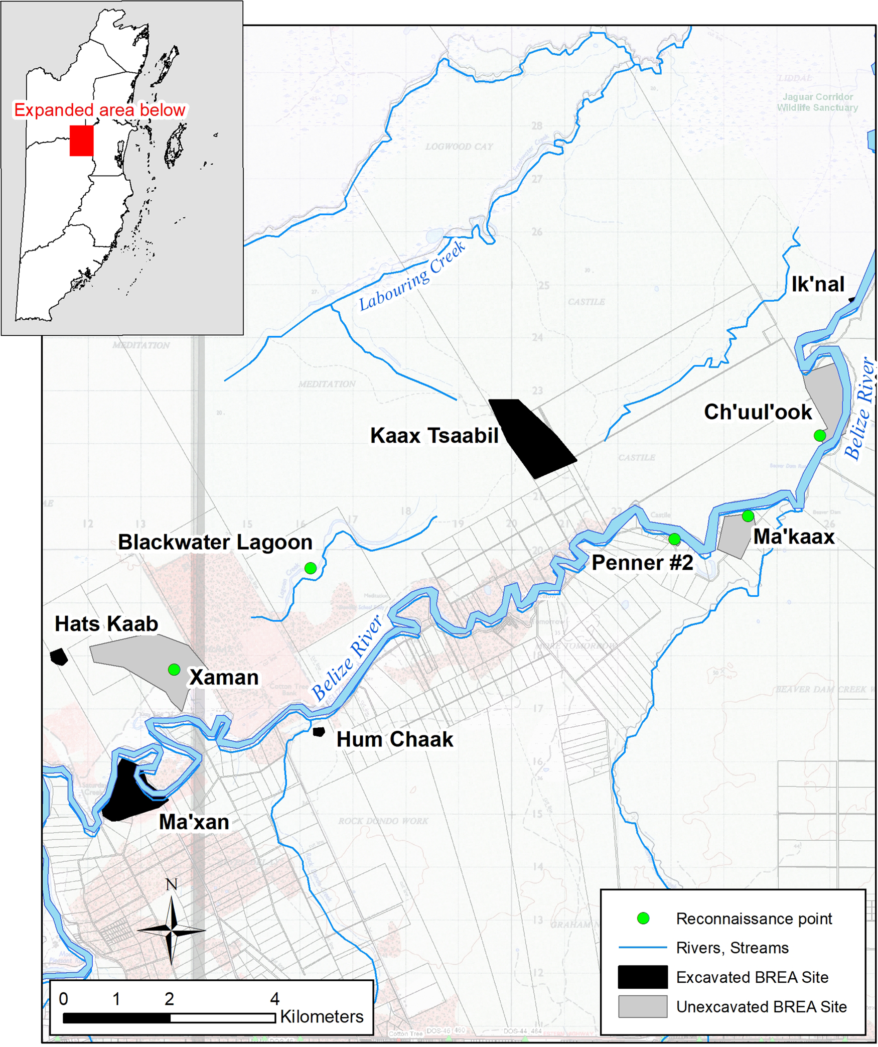
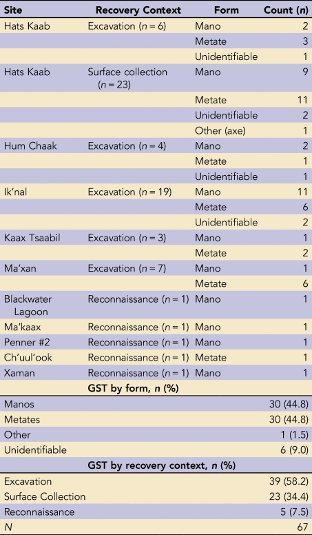
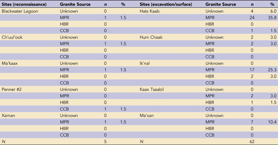
Visual inspection of the BREA GST sample indicated that the majority comprised granite or granitoid parent material (Tibbits Reference Tibbits and Harrison-Buck2015a). Of the 73 GST collected by BREA at the time of field analysis in 2014, 67 mano and metate fragments were selected for analysis (six specimens previously categorized as granite were reclassed as other stone types upon further inspection). Of this assemblage, 58.2% derived from sealed deposits via excavation (Table 2). A large portion of the assemblage was recovered during surface collection (34.3%) at the site of Hats Kaab, and through reconnaissance (7.5%) at locations in (highly) disturbed (mostly agricultural) contexts, limiting what we can say in terms of temporal observations of the data. Additionally, the entire sample of GST is fragmented, but we were still able to identify the form of most pieces: manos (44.8%), metates (44.8%), a granite axe head (1.5%), and only a small number of unidentifiable forms (9.0%). More specific typological classifications, such as those outlined by Willey and colleagues for Barton Ramie (Reference Willey, William, Bullard, Glass and Gifford1965:453–465) and Altar de Sacrificios (Willey Reference Willey1972:106–124) could not be made in most cases. The five excavated BREA sites and five reconnaissance points from which the granite sample derives all lie within 18 km of one another and are situated along the middle section of the Belize River.
BREA Granite Ground Stone Tool (GST) Forms.

RESULTS
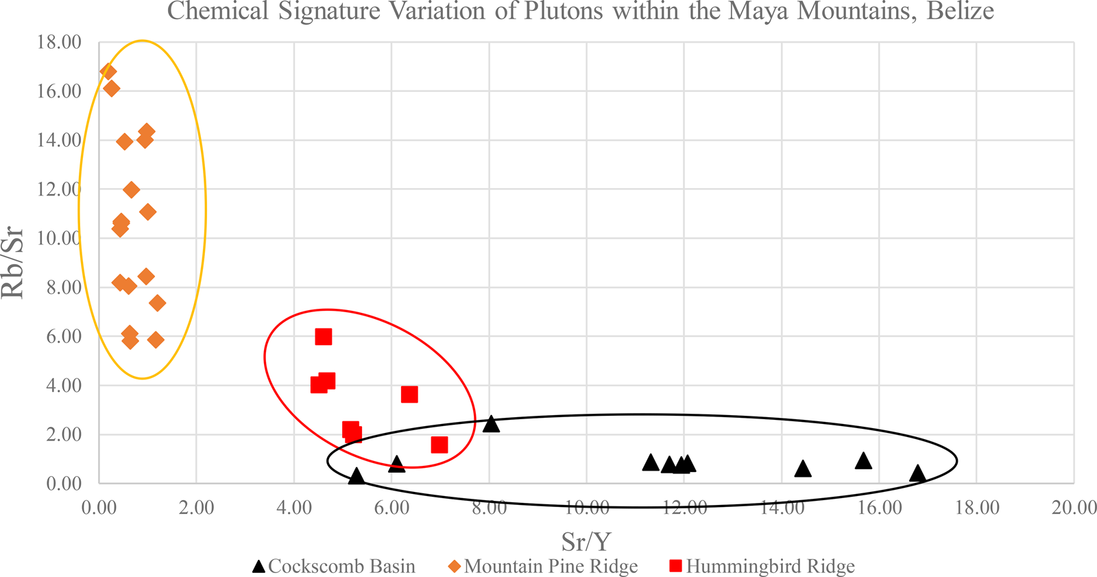
The geochemical signature range for each granite pluton was obtained through Tibbits's (Reference Tibbits2016) dissertation work. As can be seen in Figure 3, the Mountain Pine signature is the most discrete, with low strontium (Sr)/yttrium (Y) and high rubidium (Rb)/strontium (Sr) ratios. The Hummingbird and Cockscomb signatures are more variable, with higher Sr/Y and lower Rb/Sr ratios. There is some overlap between the latter two ellipses, which is related to the process of magmatic differentiation. All three plutons in the Maya Mountains are magmatically related and, because the Hummingbird and Cockscomb plutons are similar in age, it is not unusual that their signatures are similar. We focused on the ratios of Sr/Y and Rb/Sr because these elements are relatively immobile, easily detected with pXRF, and distinguishable between the three related plutons. Zircon (Zr) levels were too similar throughout the plutons to be a distinguishing parameter. Further investigation is needed to explore the overlap of the Hummingbird and Cockscomb plutons in greater depth.
Chemical signature variation for the Maya Mountain granite plutons (Mountain Pine Ridge, Hummingbird Ridge, and Cockscomb Basin). The x-axis displays ratios of strontium (Sr)/yttrium (Y); the y-axis displays ratios of rubidium (Rb)/strontium (Sr). Yellow ellipse encompasses average distribution of Mountain Pine signatures; red ellipse encompasses average distribution of Hummingbird signatures; black ellipse encompasses average distribution of Cockscomb signatures (from Tibbits Reference Tibbits2016:Figure 3.5).

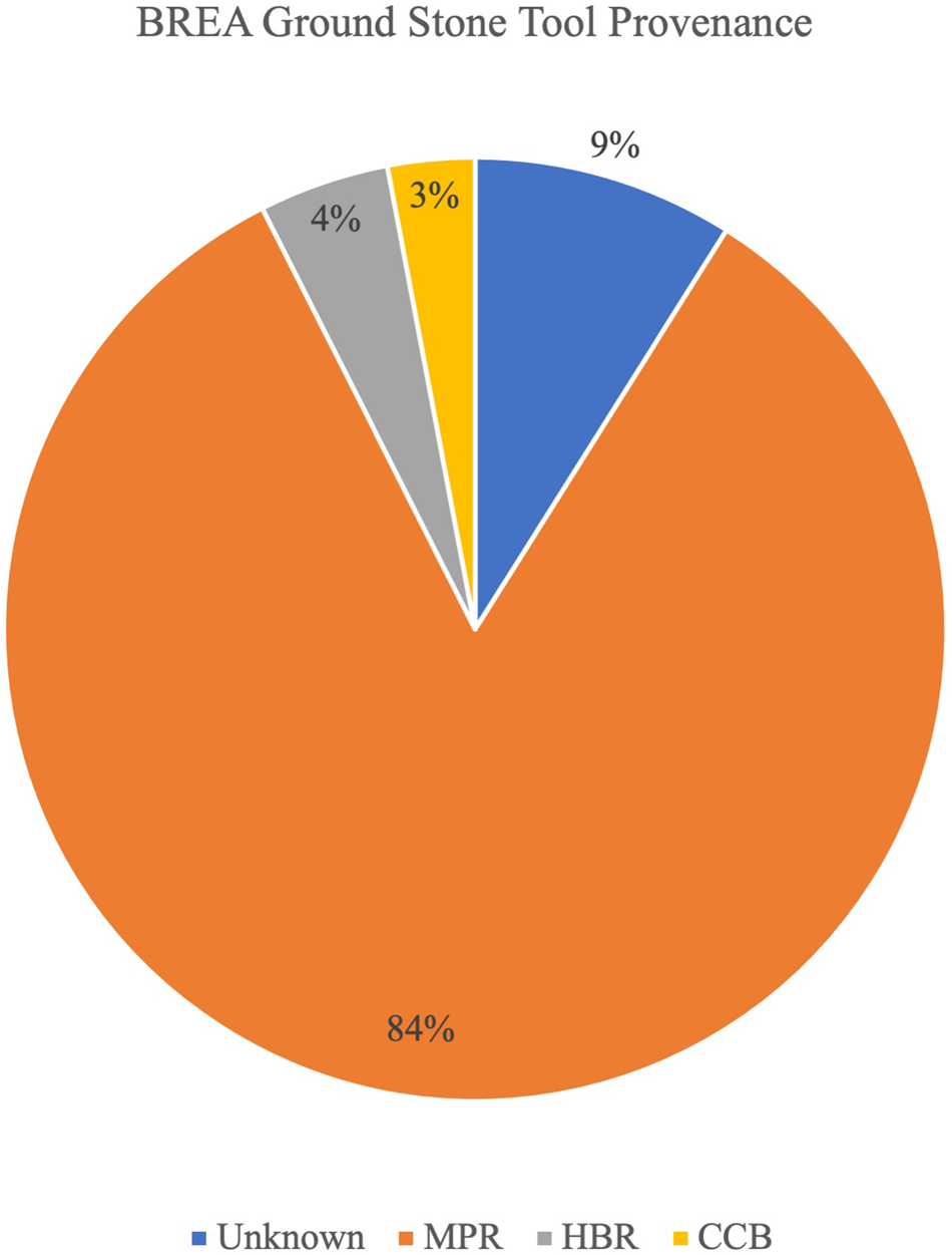
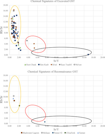
When compared with the range of geochemical signatures of the Maya Mountains granite plutons (Figure 3), pXRF analysis of the BREA granite GST revealed that most of the assemblage aligned with the Mountain Pine geochemical signature (84%), three specimens aligned with Hummingbird (4%), and two aligned with Cockscomb (3%; Figure 4; Table 3; Tibbits Reference Tibbits2016:145–146). Seven samples yielded signatures that fell just beyond the normal range for the Mountain Pine: four from Hats Kaab, two from Hum Chaak, and one from Ik'nal (top of Figure 5). Although these outlying samples may appear problematic, they are still closer to the range of variation for Mountain Pine than either the Hummingbird or Cockscomb source and are undoubtedly Maya Mountain in origin. Further geologic sampling will help to resolve this issue, as we continue to improve the breadth and depth of our outcrop sample database. Regarding form, nearly all identifiable manos (97%) and metates (90%) were sourced to the Mountain Pine outcrop, with the exception of three metate fragments from the Hummingbird source (two from Ik'nal, one from Kaax Tsaabil). Only two BREA GST fell within the range of variation for the Cockscomb pluton: an axe head from the Late Preclassic site of Hats Kaab and a mano fragment recovered from the southern side of the Belize River near Beaver Dam Creek (Penner #2).
Provenance information for granite ground stone tools (GST) at BREA sites. Abbreviations for granite plutons: MPR = Mountain Pine Ridge, HBR = Hummingbird Ridge, and CCB = Cockscomb Basin.

Chemical signatures of BREA granite ground stone tools (GST): (top) chemical signatures of GST found through excavation; (bottom) chemical signatures of GST found through reconnaissance. Yellow ellipse represents average distribution of Mountain Pine pluton signatures; red ellipse represents average distribution of Hummingbird signatures; black ellipse represents average distribution of Cockscomb signatures.

BREA Granite Ground Stone Tool (GST) Provenance.

DISCUSSION
The results yield several interesting findings, and we summarize three below. First, although locally available sedimentary limestone was used for GST production in northern Belize (Table 1), this abundant material is notably absent in the BREA GST assemblage. To date, only a small fraction of BREA GST are composed of sedimentary materials such as limestone or quartzite (an initial scan of our databases indicates <1% and includes functionally discrete types of GST, such as bark beaters). Instead, the assemblage of BREA GST (including manos and metates) appears to have derived primarily from more durable, semi-local granite, especially from the Mountain Pine granite pluton. The three metate fragments from Hummingbird and the single mano fragment from Cockscomb highlight that although infrequent, some other periodic exchange did occur between the Middle Belize Valley and these other granite sources.
Second, the lack of evidence for granite GST workshops throughout the BREA study area gives the impression that most GST were designed and produced proximate to their extraction/design locations, and that they were subsequently distributed as finished products (Peniche May 2016:300). The ethnographic record corroborates that this is a standard practice in Mesoamerica (e.g., Cook Reference Cook1982:181–196; Folan Reference Folan1982; Hayden Reference Hayden1987; Searcy Reference Searcy2011; Figure 5). Very little archaeological evidence exists in Belize to furnish understandings of where and how raw ground stone material such as granite was quarried by the ancient Maya, apart from the notable exception of the Tzib Group Mano Mound workshop at Pacbitun (Powis et al. Reference Powis, Skaggs and Micheletti2020; Skaggs et al. Reference Skaggs, Micheletti, Lawrence, Cartagena, Powis, Powis, Skaggs and Micheletti2020; Ward Reference Ward2013). The link between the BREA granite assemblage and the Mountain Pine pluton suggests that multiple workshops may have existed near this source and supplied granite GST to communities throughout the Middle and Upper Belize River Valley. Further field research focused on documenting the presence of ground stone quarries and workshops—such as has been done with obsidian throughout Mesoamerica (Clark Reference Clark1979; Healan Reference Healan1997) and chipped stone lithics in Belize (Hester and Shafer Reference Hester and Shafer1984; Horowitz Reference Horowitz2017, Reference Horowitz2021)—will help to clarify these suppositions.
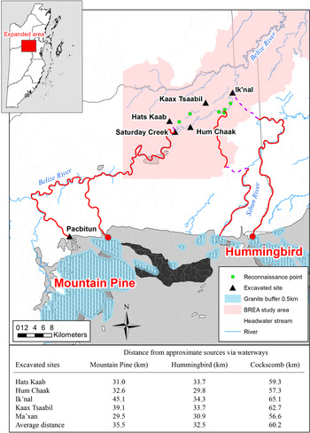
Third, given that most of the BREA GST derived from the Mountain Pine pluton, it is important to underscore that this source is not the closest (by linear distance) to all BREA sites in question, and therefore we cannot assume that a straightforward “least cost equation” directed the flow of these GST. For example, if we approximate the linear distance between the granite plutons of the Maya Mountains and sites within the BREA study area, we find that the Hummingbird source is closest overall, with an average rough distance of 32.5 km; the Mountain Pine is next at 35.5 km; and the Cockscomb is farthest at 60.2 km, nearly twice the distance of either of the other two sources (Figure 6). This simple distance/implied transport cost calculation suggests that, all other considerations aside, we should expect to find near equal amounts of Hummingbird and Mountain Pine granite in our collections, which makes the overwhelming Mountain Pine assemblage all the more intriguing. Undoubtedly, many other factors impacted where and how stone raw material was made into GST and how this GST was distributed over space and through time.
Hypothetical water routes from approximate sources of Mountain Pine, Hummingbird, and Cockscomb granite to excavated BREA sites. Red lines denote water routes and dotted-purple lines denote possible portages.

Although it is only a rudimentary measurement, the linear distance from source to destination is important to keep in mind when it comes to the consideration of heavy material transportation—as was the case for granite metates. The distances discussed above are based on overland transportation. We would be remiss if we did not allow for overwater routes (stream, river, or sea) as another distinct possibility for heavy material transportation. Graham (Reference Graham, Masson and Freidel2002:409) and others (Drennan Reference Drennan1984) have suggested that an overwater route may have been preferred to land routes for the long-distance movement of substantial loads. If we consider that some ethnographically observed metateros (people who manufacture or sell metates) regularly carried loads of up to 100 pounds (consisting of two metates and six manos, according to McBryde's [Reference McBryde1945:73] description of Nahualá metateros), then water transport would have constituted a significant decrease in human effort required for GST distribution and was likely an important mode of conveyance of bulk long-distance trade items (Sabloff and Rathje Reference Sabloff and Rathje1975). Furthermore, based on ethnohistoric and contemporary informant information, it is well established that the Belize River long served as an important conduit between the interior Maya lowlands (today, Guatemala and western Belize) and the coast (Rathje Reference Rathje and Leone1972). Although circuitous, the Belize River flows strongly eastward year round, and this could have facilitated the movement of heavy Mountain Pine granite downstream. Fewer portages would have been required for GST to move from the Mountain Pine to the Middle Belize Valley than from the Hummingbird (Figure 6).
In future work, we aim to test GST more widely to see if there is any meaningful spatiotemporal fluctuation in source distribution at BREA sites. In addition to granite, we also plan to test nonlocal, volcanic raw material (basalt, rhyolite), and we will evaluate the various overland and coastal routes by which GST may have entered the Belizean lowlands. For example, what route(s) did basalt GST travel, and were they bundled with the transport of other volcanic items such as obsidian from the Guatemalan highlands? Norman Hammond (Reference Hammond1972) suggested that obsidian from the Ixtepeque source in the southern Guatemalan highlands was brought into the interior of central Belize via the Río Motagua and transported up the Caribbean coast, and then inland either on foot or upriver. Although this simplified model has received criticism (Johnson Reference Johnson, Hester and Hammond1976; Sidrys Reference Sidrys1981), it has also partially withstood the test of time, albeit modified to accommodate data indicating that riverine and coastal routes were used to transport other types of obsidian as well. For example, El Chayal obsidian (thought by Hammond [Reference Hammond1972] to move only through interior overland routes) was found to dominate the assemblages of coastal sites such as Moho Cay, Wild Cane Cay, and other island transfer locations in southern and central Belize (Healy et al. Reference Healy, McKillop and Walsh1984; MacKinnon Reference MacKinnon1989; McKillop Reference McKillop1996; McKillop et al. Reference McKillop, McAnany, Isaac, McAnany and Isaac1989). Multiple routes seem to have been used simultaneously to transport obsidian from the same sources, perhaps bundled with other trade items such as basalt and rhyolite GST that were derived from nearby volcanic deposits. Future sourcing of both volcanic and granite GST will allow us to further examine this question of source material, distribution, and transport of various goods over time and space.
Although this study gets us one step closer to perfecting a reliable, nondestructive, field-ready technique for sourcing heterogenous and coarse-grained granite GST, there clearly remains much more work to be done. We refrain from making any claims about temporal shifts, other than to point out that the single Late Preclassic site in the study area (Hats Kaab) yielded GST almost exclusively from Mountain Pine—apart from one Cockscomb axe head. The other sites all date predominately to the Terminal Classic/Postclassic, yielded mostly Mountain Pine granite, and included the only three specimens from the Hummingbird source (two from Ik'nal and one from Kaax Tsaabil). In future research, we plan to analyze the remaining 257 pieces of GST that the BREA Project has unearthed since the initial work to determine if the Hummingbird source or any other GST types are restricted to specific time periods and/or geographical locations.
CONCLUSIONS
In this study of ancient Maya GST, we have attempted to illustrate how pXRF can be applied to heterogenous tool stone assemblages to reveal important information regarding the regional distribution and exchange of these objects across Belize. This case study demonstrates the cogency of this sourcing application to coarse-grained materials such as granite. The results of this initial study give rise to a series of derivative questions. For example, although we now know that parts of the Middle Belize Valley were sourcing almost all granite GST from the Mountain Pine pluton in the Upper Belize Valley, there were select instances of exchange/movement between the less commonly represented granite sources. Whether the lower proportions of GST from the Hummingbird and Cockscomb sources was the result of spatial and/or temporal shifts, a response to resource accessibility and/or cultural preference, or some other larger sociopolitical dynamics is unknown. Furthermore, how were GST from different sources, and different functional categories, distributed across the socionatural landscape? And what kind of variation in these patterns occurred over space and through time? Geochemical sourcing stands to resolve these and other questions, and it offers a fruitful methodology for future research into GST that will provide a fuller understanding of the processes of design, exchange, and consumption across the Maya lowlands. Because GST become ubiquitous following the development of agriculture around the globe, this innovative granite sourcing technique will no doubt prove useful to other regions of Mesoamerica and beyond.
Acknowledgments
This research was made possible by funding and support from the University of Iowa, the Departments of Anthropology at the University of New Hampshire and the University of Vermont, and the Department of Mathematical and Natural Sciences at Chadron State College. We thank, in particular, Matt Tibbits and Sarah Wigley for their assistance and encouragement during the collection and processing of the data. We also thank the Belize Institute of Archaeology and National Institute of Culture and History for their support. As always, much appreciation goes out to all the staff, students, and workers associated with the Belize River East Archaeology Project.
Data Availability Statement
The ground stone tools analyzed in this research are housed in a secure artifact repository in the village of Crooked Tree, Belize, under the auspices of the Belize River East Archaeology (BREA) Project. The digital data used in this work are held in the physical and cloud computing storage of the BREA Project at the Universities of Vermont and New Hampshire, as well as at Chadron State College. For access to the raw pXRF data, please see Tibbits's (Reference Tibbits2016) dissertation or e-mail the authors.
Supplemental Material
For supplemental material accompanying this article, visit https://doi.org/10.1017/aap.2021.26.
Supplemental Table 1. Sites and References for Table 1.
Supplemental Table 2. Observed Average Modal Abundances of Mountain Pine, Hummingbird, and Cockscomb Granites (from Tibbits Reference Tibbits2016:48).
Supplemental Table 3. Comparison of Values Obtained on Known Granite Geologic Reference Materials AC-E and GS-N (from Tibbits Reference Tibbits2016:52).
Supplemental Table 4. Comparison of pXRF and Lab-Based XRF Techniques Showing Rb, Sr, and Y Results (from Tibbits Reference Tibbits2016:56).
Supplemental Figure 1. Comparison of whole rock pXRF results and XRF results on powdered samples.
Supplemental Figure 2. The results of the Monte Carlo Simulation as shown by a bivariate chart.
Supplemental Figure 3. Calibration curves for all analyzed geochemical standard materials.