


Introduction
Archaeological examinations of disparities in wealth have the potential to shed light on longer trajectories of inequality when compared to historical data alone. Such an approach, however, needs to be sufficiently standardized in order to yield comparative results, while also employing meaningful metrics of wealth in any one sociocultural context. Walking this methodological tightrope is no easy feat. Following the goals of this Compact Special Section (Chase Reference Chase2017; Feinman et al. Reference Feinman, Faulseit, Nicholas, Kohler and Smith2018; Thompson et al. Reference Thompson, Feinman and Prufer2021), we employ the Gini coefficient to examine residential size differentiation within two Late Classic Maya polities in the Belize River Valley, Baking Pot and Lower Dover. The Gini coefficient is commonly used to measure wealth inequality, although it is, in reality, a measure of the unevenness of a batch of the input variable the coefficient is based on (not dissimilar to diversity indices; see Peterson and Drennan Reference Peterson, Drennan, Kohler and Smith2018). Based on this unevenness, a higher Gini coefficient is usually associated with greater degrees of wealth inequality (see Chase et al. Reference Chase, Thompson, Walden and Feinman2023), but this study uses the Gini coefficient to characterize residential differentiation at Baking Pot and Lower Dover, discussing the implications of these Gini coefficients in relation to political models of labor organization (Abrams Reference Abrams1994).
The Belize River Valley
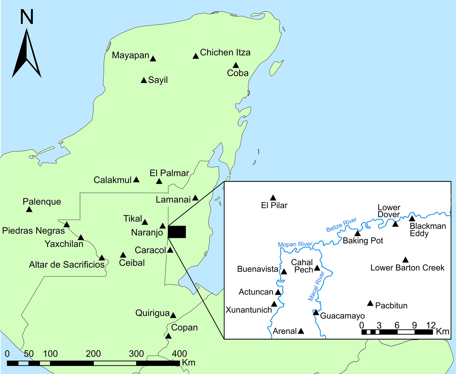
The Upper Belize River Valley covers approximately 125 km2, extending 30 km eastward from the Late Classic center of Xunantunich, downriver to the center of Blackman Eddy (Figure 1). The Macal and Mopan rivers meander through the westward portion of the valley to their confluence near the modern town of San Ignacio, where they converge into the Belize River. The Belize River is bordered on its north and south by expansive, agriculturally fertile alluvial plains which give way to limestone escarpments. The river represented a vital transport artery from the Peten, Guatemala to the Caribbean coast. Sedentary populations appear in the archaeological record by the Early Preclassic (~1100–1000 cal b.c.), and sizeable polities, including Actuncan, Blackman Eddy, and Cahal Pech form by the Late Preclassic (300 b.c.–a.d. 300; see Awe Reference Awe1992; Ebert et al. Reference Ebert, May, Culleton, Awe and Kennett2017; Garber et al. Reference Garber, Brown, Awe, Hartman and Garber2004). During the Classic period, the Belize River Valley represents an intensified microcosm of the peer-polity dynamics apparent across the Lowlands. In the Upper Belize Valley, as elsewhere, the Classic polities were headed by a royal lineage, which, despite acting as clients to larger external suzerains, possessed many of the trappings of political autonomy, such as royal titles, jade funerary masks, and architectural indicators of power (Awe Reference Awe2013; Helmke and Awe Reference Helmke and Awe2012).
Regional map with major sites mentioned in text. Inset shows Upper Belize River Valley.
The Classic period Upper Belize Valley polities contained populations ranging between 2,000 and 10,000 people, dispersed around monumental epicenters. Despite the impacts of modern settlement and agriculture, the Belize River Valley has seen substantial settlement survey, and we have a solid understanding of population distributions. Most commoner populations clustered into neighborhoods of 5–16 households, each associated with higher-status commoner neighborhood heads. Neighborhoods themselves were clustered into larger, district-level entities consisting of 20–50 households, headed by intermediate elite district heads based at minor centers. The intermediate elite concept was applied to examine the agency and strategies of these inter-hierarchical sub-royal elites, who were interfacing with commoner clients and apical elite overlords (Walden et al. Reference Walden, Ebert, Hoggarth, Montgomery and Awe2019). Multiple districts combined to form polities headed by apical elites based at major centers (Bullard Reference Bullard1960; Smith Reference Smith2011; Thompson et al. Reference Thompson, Walden, Chase, Hutson, Marken, Cap, Fries, Guzman Piedrasanta, Hare, Horn III, Micheletti, Montgomery, Munson, Richards-Rissetto, Shaw-Müller, Ardren, Awe, Kathryn Brown, Callaghan, Ebert, Ford, Guerra, Hoggarth, Kovacevich, Morris, Moyes, Powis, Yaeger, Houk, Prufer, Chase and Chase2022; Yaeger Reference Yaeger, LeCount and Yaeger2010). These hierarchically nested spatial clusters of commoners likely provided the labor to construct their respective centers. The division of the population into elite-headed units permeated the political landscape, although inter-polity variability in processes of centralization/segmentation is evident.
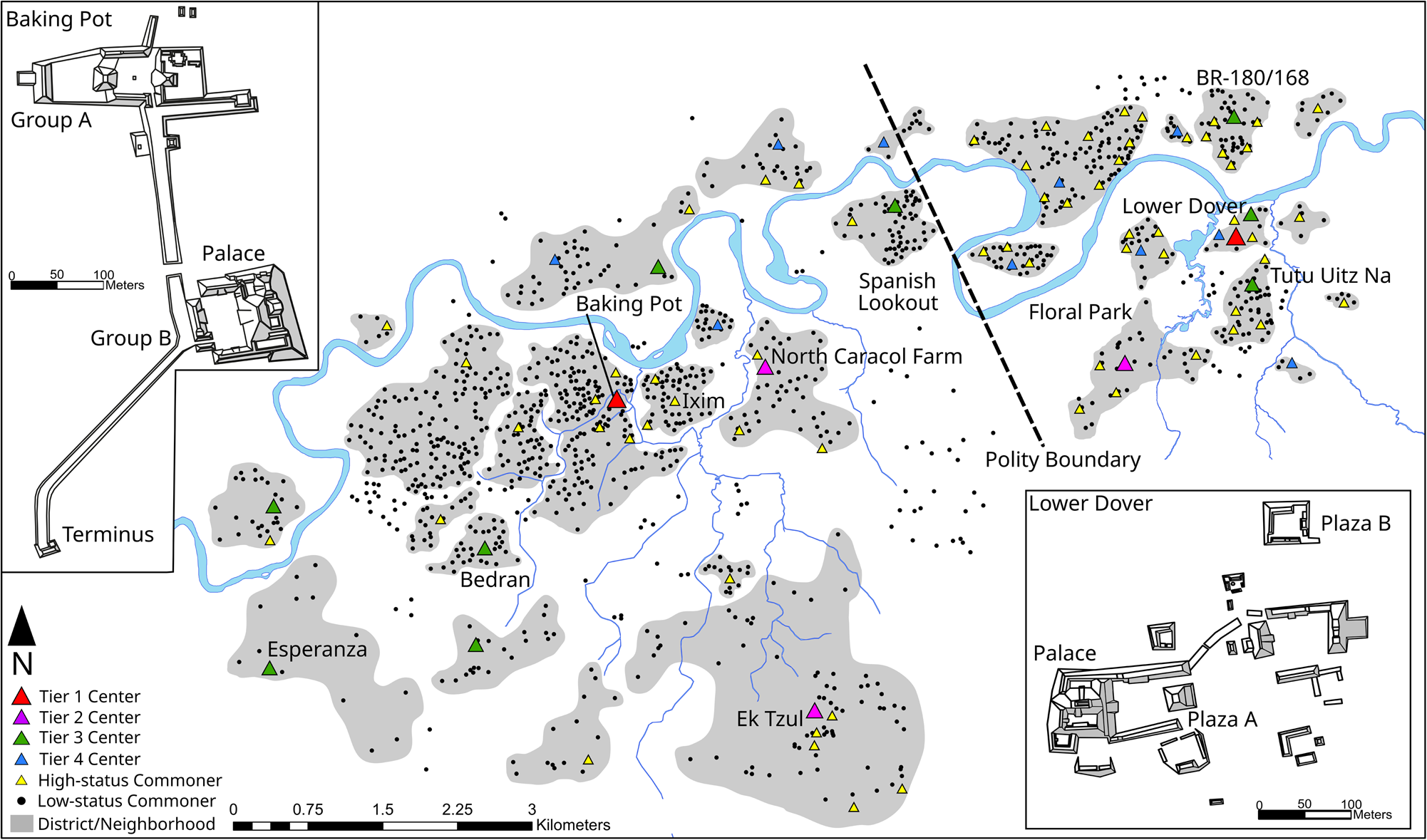
The polities of Baking Pot and Lower Dover represent idealized ends of a spectrum of apical elite centralization versus intermediate elite segmentation. Extensive settlement pattern and architectural analyses reveal that Baking Pot and Lower Dover represent the capitals of two separate political units (Walden et al. Reference Walden, Hoggarth, Ebert, Fedick, Biggie, Meyer, Shaw-Müller, Qiu, Ran, Ellis, Watkins, Britt Davis, Guerra, Helmke and Awe2023a). The civic-ceremonial center and associated apical elite at Baking Pot grew slowly from the Late Preclassic to the Late Classic (a.d. 600–900), in tandem with surrounding populations. In contrast, Lower Dover was a Late Classic imposition on a densely settled landscape. These divergent developmental pathways produced two very different political entities. With an architectural volume of 280,000 m3, the Baking Pot civic-ceremonial center was one of the largest in the Classic period Belize Valley (Figure 2). The Baking Pot palace comprised approximately one-third of the total architecture by volume (90,000 m3), and the elites who lived there likely exerted territorial control over an area of ~45 km2, and a population of ~6,500 people (927 households), many of whom were aggregated around the core (Figure 3; Walden et al. Reference Walden, Hoggarth, Ebert, Fedick, Biggie, Meyer, Shaw-Müller, Qiu, Ran, Ellis, Watkins, Britt Davis, Guerra, Helmke and Awe2023a). The Baking Pot polity has a core zone, with dense settlement arranged into districts around small, intermediate elite households. These intermediate elites lacked large ceremonial architecture and lived in relatively small houses, but possessed ostentatious wealth items (Conlon and Powis Reference Conlon, Powis and Garber2004; Hoggarth Reference Hoggarth2012). The Baking Pot borderlands did contain more powerful intermediate elites, but even the largest of these are less than one-fifth of the size of the Baking Pot capital (e.g., Ek Tzul, North Caracol Farm, Spanish Lookout; see Hoggarth et al. Reference Hoggarth, Awe, Jobbová and Sims2010; Walden et al. Reference Walden, Hoggarth, Ebert, Fedick, Biggie, Meyer, Shaw-Müller, Qiu, Ran, Ellis, Watkins, Britt Davis, Guerra, Helmke and Awe2023a). In contrast, the civic-ceremonial core of Lower Dover was half the size of Baking Pot (148,000 m3). The Lower Dover palace (19,000 m3) was one-fifth of the size of the Baking Pot palace. Lower Dover also controlled a much smaller area of ~16 km2, with a population of ~2,400 (352 households), many of whom lived in districts disembedded from the core. At Lower Dover, district heads are represented by three large minor centers (BR-180/168, Floral Park, and Tutu Uitz Na), located within a 2 km radius of the core. These disparities in the political control of labor between apical elites, intermediate elites, and commoners, and their divergent developmental trajectories, make Baking Pot and Lower Dover ideal case studies for comparisons of residential size.
Polities map showing polity capital architecture.
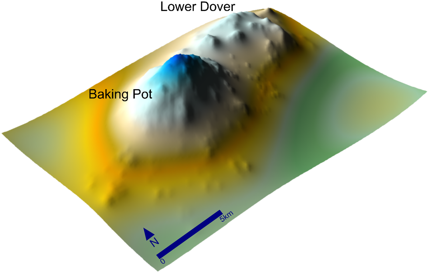
Inverse distance population surface (adapted from Walden Reference Walden2021:Figure 6.6).
Adapting methods to local contexts: Taphonomy, settlement preservation, and house size
Gini coefficients are typically used to assess wealth concentration within a population (Chase et al. Reference Chase, Thompson, Walden and Feinman2023; see also Peterson and Drennan Reference Peterson, Drennan, Kohler and Smith2018). Gini coefficients range between 0 (perfect equality) to 1 (maximal inequality). Complete homogeneity of values within a distribution would result in a value of 0, whereas increasing degrees of heterogeneity would result in values increasingly closer to 1. The Gini coefficient is defined mathematically from the Lorenz curve, a plot showing an equality metric (x axis) against the proportion of a population (y axis).
Several local considerations were accounted for when adapting these methods to this study area. Despite the advantage that cleared land offers the settlement archaeologist (see Willey et al. Reference Willey, Bullard, Glass and Gifford1965), the Belize Valley context poses three challenges to a holistic understanding of settlement patterns: (1) modern settlement, (2) agricultural plowing, and (3) meandering rivers (see also Munson et al. Reference Munson, Scholnick, Mejía Ramón and Aragon2023). Our focus on Baking Pot and Lower Dover sidestepped the issue of modern settlement as contemporary occupations are sparser in the study area. While plowing is especially bad on the alluvial bottomlands of the valley, these areas are farther from sources of limestone, such that house mounds were built instead of river clay and cobbles. House mounds have subsequently been smoothed out by plowing (though not entirely cleared away), thus expanding their original shape and layout, but maintaining their volume over a larger area. River movement is less problematic because the spatial distribution of sites suggests that while the river destroyed lots of commoner settlement, most of the intermediate elite district centers remain intact. The fact that river destruction disproportionately impacted commoner over elite house mounds exerts less bias on the method given the large sample of commoner house mounds relative to elites. This is clear because few intermediate elite centers seem to be missing given the spatial distribution of clustering along the river.
The proclivity of the Upper Belize Valley Maya to reside in groups composed of just one or two structures (Ford Reference Ford and Garber2004:244) resulted in open-sided (not four-sided) patio groups, which are difficult to spatially delimit. This issue of delimiting household space, coupled with the aforementioned plowing, rendered overall house group/plazuela volume (m3) a more reliable metric of house size than volume of individual structures, or overall area (m2). Elite ceremonial architecture was systematically removed from the dataset, but commoner ceremonial architecture (e.g., small shrines) could not be removed, as excavation is required to distinguish these structures from residential architecture. The local developmental trajectory saw 2,000 years of continuous occupation resulting in a complex settlement palimpsest, which has implications for synchronic analyses because some centers developed in a fashion which was not concomitant with surrounding settlement (Kurnick Reference Kurnick2016). To best mitigate this issue, we consider our Gini coefficients representative of the Late Classic settlement apogee when all excavated house mounds in the region were occupied.
Results
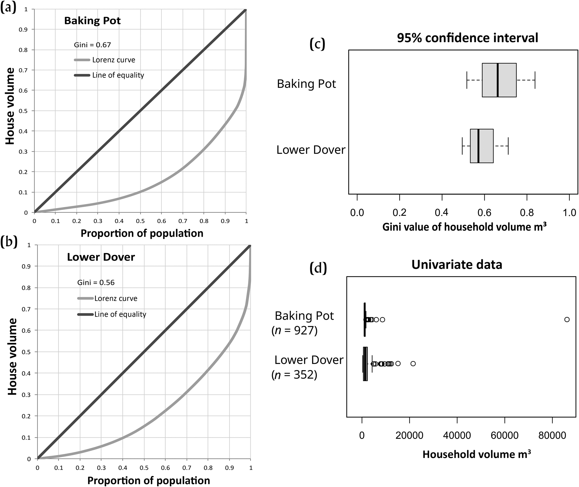
Analysis produced a Gini coefficient of 0.67 for Baking Pot, with a wide confidence interval (CI), and 0.55 for Lower Dover, with a much narrower CI (Figures 4a–4c, Table 1). The inflection point at the end of the Baking Pot Lorenz curve shows the impact of the disproportionally huge apical palace compared to Lower Dover's less concave Lorenz curve (Figure 4d). This result was expected because of the differences in political centralization and developmental trajectory. That said, Lower Dover is still highly ranked in terms of residential differentiation. Figure 4c shows overlap at the 95 percent confidence interval; this sizeable overlap is reflective of the fact that the distribution of residential sizes for each of the two polities is similar, but the disproportionally larger palace at Baking Pot is likely responsible for the higher Baking Pot Gini coefficient (see Figures 4a and 4d). The samples for each polity represent an overwhelming majority of the house mounds in the two sampling universes because missing house mounds are limited to the small number destroyed by riverine movement. Survey in pastures shows that non-mounded architecture is virtually non-existent. This is unsurprising given the miniscule amount of labor it takes to construct a low platform relative to its considerable benefits in a low-lying environment. Regardless, the sample of mounded house structures included here is in no way representative of a larger sample of non-mounded residences anyway.
Lorenz curves for (a) Baking Pot and (b) Lower Dover; (c) box and whisker plot of Gini coefficients and associated error ranges; and (d) univariate plot of household volumes (m3).
Basic statistics for Baking Pot and Lower Dover.

Discussion: Political strategies, labor flow, and residential size
Our application of the Gini coefficient to assess variability in residential volumes corroborates our understanding of political dynamics at Baking Pot and Lower Dover. The higher Gini coefficient at Baking Pot reflects a larger apical palace, comparably smaller minor centers, and a larger commoner population. In contrast, Lower Dover has a lower Gini coefficient because it has a smaller palace, comparatively larger minor centers, and a smaller commoner population. Interestingly, despite their differing degrees of political centralization and developmental trajectories, the Gini coefficients for Baking Pot and Lower Dover are not too dissimilar. While Lower Dover falls in the range of residential volume Gini coefficients for Classic Maya cities (0.54–0.62) presented by Thompson and colleagues (Reference Thompson, Feinman and Prufer2021: Figure 5) and others in this Compact Special Section, Baking Pot is only slightly higher, which is due to the large size of the palace, which reflects the concentration of labor in the hands of the apical elite.
Other possible wealth metrics are needed to contextualize these findings (Peterson and Drennan Reference Peterson, Drennan, Kohler and Smith2018; see also Horn III et al. Reference Horn III, Tran and Ford2023; Munson et al. Reference Munson, Scholnick, Mejía Ramón and Aragon2023). While comparison of portable wealth items using Gini coefficients is beyond the scope of this article, previous research shows that the proportions of such items do not always correlate with residential size (Walden et al. Reference Walden, Biggie, Shaw-Müller, Levin, Qiu, Nachamie, Ellis, Mink, Izzo, Hoggarth, Ebert, Guerra, Awe, Quequezana and Walden2023b). General issues with both wealth metrics aside (e.g., taphonomy, portability of items), this lack of correlation is not surprising given the fact that these two metrics of inequality reflect very different types of relationships and networks. In the Classic period Belize Valley, constructing a larger house appears contingent upon the deployment of top-down coercive and consensual strategies to accrue labor from subordinates, whereas access to ostentatious wealth items, such as Naranjo polychromes, depended upon lateral or bottom-up relations with peers and overlords.
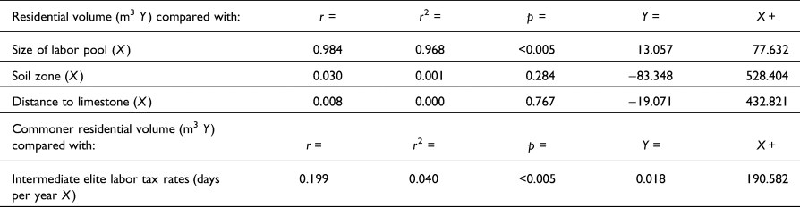
There are numerous factors underlying differentiation in residence size. These might range from access to labor to control of resources, proximity to construction materials, or the scale of labor tax extracted by suzerains. Residential volume (m3) at Baking Pot and Lower Dover is strongly positively correlated with the size of the labor pool, or the population of the associated spatial cluster, with an extremely high level of significance (p = <0.005; see Table 2). An r 2 value of 0.968 indicates that more than 96 percent of the variation in residential volume is accounted for by the size of the associated labor pool. Other variables explain a negligible percentage of the variability. Residential volume shows a weak negative correlation with soil zone and this has a low level of statistical significance (p = 0.284). The r 2 value of 0.001 indicates that only 0.01 percent of the variation in residential volume is accounted for by the quality of nearby soils for traditional hand cultivation. These findings reflect the fact that large and small house mounds are situated on most soil zones. Residential volume shows a weak negative correlation with distance to limestone construction materials and this has a very low level of statistical significance (p = 0.767). The r 2 value of −0.000 indicates that 0 percent of the variation in residential volume is accounted for by distance to limestone construction materials and this result has very little statistical significance (p = 0.767). This relationship is explained by the fact that house mounds were often filled with river clay or cobbles. Intermediate elite tax rates were calculated using energetic assessments divided by the number of commoners in the district. Commoner residential volume shows a highly significant positive correlation with intermediate elite labor tax rates (p = <0.005). However, the r 2 value of 0.040 indicates that only 4 percent of the variation in residential volume is accounted for by overarching elite tax rates. This lack of correlation is the product of palimpsest issues associated with survey data, as excavation data from districts reveal a strong correlation between construction tax rates at minor centers and commoner construction (Walden Reference Walden2021).
Logistic regressions of residential volume (m3) and commoner residential volume (m3) with different variables.
The linear regression shows that residential volume in the Belize River Valley correlates with labor. While Gini coefficients are usually employed to assess wealth, in this context it reflects how concentrated labor was within a polity. Far from diminishing the value of the approach, it paves the way for insightful assessment of how labor was hierarchically structured and sanctioned by competing elites. For instance, at Lower Dover, the combination of an architectural energetics approach, settlement patterns (labor catchments), and artifactual evidence of different strategies for securing subordinate labor (e.g., hosting feasts and/or ceremonies, redistribution of wealth items) allowed a contextualized understanding of different forms of labor organization at different levels of the political hierarchy (Walden et al. Reference Walden, Biggie, Shaw-Müller, Levin, Qiu, Nachamie, Ellis, Mink, Izzo, Hoggarth, Ebert, Guerra, Awe, Quequezana and Walden2023b).
In this framework, most low-status commoner households were constructed by the occupants, or perhaps through reciprocation with immediate kin nearby. High-status commoner neighborhood heads drew on commoner labor from members of the neighborhood, which was reciprocated through hosting feasts and ceremonies. Low-status commoners likely fissioned from the high-status households at their epicenters to gradually form neighborhoods that identified as corporate/kin entities. Hence, these neighborhoods may represent more fundamental basal societal units for comparison than their constituent households (Hayden and Cannon Reference Hayden and Cannon1982). Subsequently, at the neighborhood level it may make sense to think of variability in residential size as reflective of differentiation, not inequality (Drennan and Peterson Reference Drennan, Peterson and Smith2012:76–79). Intermediate elites at tertiary minor centers commanded substantial labor from surrounding commoners, which was grounded once again in feasting, but also district-scale ancestor veneration ceremonies and the redistribution of portable wealth. Secondary minor centers and major centers are larger in scale, and for the most part, their resident elites did not seem to offer much to subordinates in exchange for their labor, suggesting corvée labor organization (Abrams Reference Abrams1994; see also Walden Reference Walden2021).
Labor could be mandated through recourse to force or freely volunteered by commoners (Abrams Reference Abrams1994). It seems that more powerful intermediate elites and apical elites employed more coercive policies than tertiary intermediate elites, who were reliant on more commensal policies. Establishing where the Belize Valley elites sat on this spectrum of labor organization is beyond the scope of this article; however, it is worth noting that none of the architecture seems to have been the product of purely collective endeavors. Labor was not flowing into communal monuments without clear elite associations, even at the district scale. Instead, labor was used to construct elite residences and lineage shrines. While the construction of lineage shrines could serve as a symbol of community identity, these structures emphasized the importance of the elites interred within.
Conclusion
Political actors at each hierarchical level of Classic Maya society had an increasingly wider array of roles and duties interacting with subordinates, peers, and overlords (Foias Reference Foias2013). Such a dynamic is evident in the higher proportions of feasting or ritual paraphernalia associated with neighborhood head households than with lower-status dwellings (Hoggarth Reference Hoggarth2012; Walden et al. Reference Walden, Watkins, Shaw-Müller, Ebert, Messinger, Guerra, Awe, Targa and Martín Medina2020; see also Robin et al. Reference Robin, Meierhoff, Kestle, Blackmore, Kosakowsky, Novotny and Robin2012). For example, at the most grandiose scale, Martin (Reference Martin2020:349–350) attributes numerous functions to parts of the palatial complex at Calakmul (Campeche, Mexico). These functions include residences for the ruler's multiple wives, the offspring of client rulers, and administrative space, which was necessitated by the dynasties’ position at the head of a large multi-polity network. While the notion that a broader array of activities was occurring in palaces compared to commoner residences is not new, the fact that similar roles and duties (and an expanded array of functions associated with household space) were hierarchically nested means that not all residences were alike. In fact, as one moves further up the political hierarchy, the less “domestic” residential space becomes. Apical elite palaces at Baking Pot and Lower Dover hosted a greater array of political, economic, and ceremonial activities than minor centers, which in turn fulfilled many functions which did not occur at the commoner scale (Watkins Reference Watkins2019). This nested dynamic has implications for the comparison of residential sizes. This is exemplified by the Baking Pot palace, which likely served more functions than its counterpart at Lower Dover due to the larger polity size.
The use of Gini coefficients to understand disparities in residential volume in the Belize River Valley puts a finer point on the relative concentration of labor, political centralization, and polity formation trajectories. Previous research has shown that neighboring Classic Maya polities can display very different degrees of political centralization and control over subordinates (de Montmollin Reference de Montmollin1995; Golden et al. Reference Golden, Scherer, Muñoz and Vásquez2008). Application of the Gini coefficient to residential variation at Baking Pot and Lower Dover has revealed variability in the power and authority of ruling elites. Moreover, our case study reveals that greater political centralization of labor flows at Baking Pot was a product of its gradual growth alongside regional demography, in contrast to Lower Dover, whose late emergence resulted in the inability of the emerging apical elite to fully wrest control of labor networks from powerful pre-existing intermediate elites. Future research will employ multiple variables representing different kinds of wealth disparities, such as portable wealth, house size, and access to resources to clarify the relationships between these varying dimensions.
Acknowledgments
We thank the Belize Institute of Archaeology, under the direction of Dr. Melissa Badillo, for its support of the BVAR project. Thanks go to Dick Drennan, Patrick Mullins, and Igor Chechushkov for providing input on earlier drafts of this manuscript. We acknowledge three anonymous peer reviewers whose insightful input has greatly improved our contribution. Special thanks go to Adrian Chase and Amy Thompson for organizing the comparative Gini/inequality project and providing feedback on this article.
Competing interests declaration
The authors declare none.
Data availability statement
All data summarized herein is freely accessible for download through the University of Pittsburgh Center of Comparative Archaeology.
Funding statement
Financial support was provided by NSF (DDIG program; BCS-1914638 J. Walden and M. Bermann), the Rust Family Foundation (J. Walden), the University of Pittsburgh Department of Anthropology, International Studies Fund, and Center for Latin American Studies (J. Walden and J. Hoggarth).


 Open access