


Introduction
Ethnographies of New Guinea Highland societies have been heavily, and often selectively, drawn upon as analogues for prehistoric pasts elsewhere in the world, especially in Europe (Roscoe Reference Roscoe2009; Spriggs Reference Spriggs2008). However, there has been surprisingly little archaeological excavation in the Highlands focused explicitly on the recent past that might test our capacity to extend analogies from the ‘ethnographic present’ backwards over decades or centuries. Here, the excavation of relatively recent house structures in the Lower Tagali Valley, Hela Province (formerly part of the Southern Highlands), in the Highlands of Papua New Guinea provides an ethnographic study of frontier expansion by Huli-speaking populations.
Frontiers, borderlands and boundaries have long been key concepts in archaeological theory to explain how social groups locate themselves within landscapes (Green & Perlman Reference Green and Perlman1985; Waselkov & Paul Reference Waselkov and Paul1982). Popularized by Turner in his spatial study of the American West (e.g. Turner Reference Turner1920), the idea of frontier as a spatial metaphor has since acquired explanatory power in disciplinary theory (e.g. Perry Reference Perry1963; Reynolds Reference Reynolds1981; see McGrath & Russell Reference McGrath, Russell, McGrath and Russell2022 for a summary of frontier historiography as it relates to Indigenous Studies). These earlier works have since been critiqued on the basis of Eurocentrism (e.g. Richter Reference Richter2009) and the colonizing myth of the frontier in staging imagined colonial geographies (Carter Reference Carter1987, 158ff; cf. Reynolds Reference Reynolds1981). In archaeology, the concept has taken a somewhat different pathway, periodically invigorated by key developments, including:
• Notions of frontiers for understanding human expansions into previously unsettled domains, such as in the pioneering expansions into the Pacific (Shaw et al. Reference Shaw, Hawkins and Becerra-Valdivia2022);
• Explorations of colonial frontier conflicts and contemporary confrontations with settler-colonial pasts (e.g. Barker et al. Reference Barker, Wallis and Burke2020; Wallis et al. Reference Wallis, Burke, Cole and Barker2019; see Reynolds Reference Reynolds1981);
• The post-colonial critique and recognition of Indigenous agency in negotiating cross-cultural encounters has fundamentally reframed how scholars think of the geographical or ‘fixed’ frontiers (Lightfoot & Martinez Reference Lightfoot and Martinez1995; McNiven & Russell Reference McNiven, Russell, David and Wilson2002; Russell Reference Russell2001; Reference Russell2012; Torrence & Clarke Reference Torrence and Clarke2000; Wolski Reference Wolski and Russell2001); and
• Social landscape approaches situating frontiers within lived and material worlds (Bender Reference Bender2001; Reference Bender, Ucko and Layton2003; David & Thomas Reference David and Thomas2008; Witcher et al. Reference Witcher, Tolia-Kelly and Hingley2010).
Despite this plethora of approaches, frontier and borderland studies have developed mainly within the context of imperial, colonial and neo-colonial contexts (e.g. Bagaloni & Pedrotta Reference Bagaloni and Pedrotta2018; Gleave et al. Reference Gleave, Williams and Clarke2020; Hingley Reference Hingley2018). Only a handful of archaeological studies have sought to probe the idea of frontiers, spheres and border zones in non-state settings (e.g. McNiven Reference McNiven2022; Sawchuk et al. Reference Sawchuk, Goldstein, Grillo and Hildebrand2019; Shaw et al. Reference Shaw, Hawkins and Becerra-Valdivia2022). Fewer still have sought to integrate detailed ethnographies of Indigenous conceptions of place, landscape, settlement systems and personhood (e.g. Ambrose et al. Reference Ambrose, Clark and Brandt1984; Lane Reference Lane2004; Reference Lane, Bollig, Schnegg and Wotzka2013; see also Wengrow & Graeber Reference Wengrow and Graeber2018). Such is the dearth of thinking on notions of frontiers in Indigenous settings that Paul Carter (Reference Carter1987, 158ff) wondered whether the notion of the frontier was relevant to understand Indigenous spatial histories and geographies (see also Russell Reference Russell2012, 120).
This paper engages with some of these issues in seeking to understand the processes of pioneering expansion by Huli-speaking settlers southwards into the Lower Tagali and Komo valleys (Fig. 1) in the Highlands of Papua New Guinea. The area had been thinly populated by members of other, unrelated ethnolinguistic groups prior to Huli colonization. Here, the excavation of relatively recent house structures in Papua New Guinea's Hela Province (formerly part of the Southern Highlands) has allowed for constructive reference to detailed ethnographic and oral accounts of local Huli colonizing practices and processes. This study extends a sense of the frontier both to the boundary between archaeology and ethnography, and to the inexorable expansion of distinctive Huli practices of landscape transformation and use.
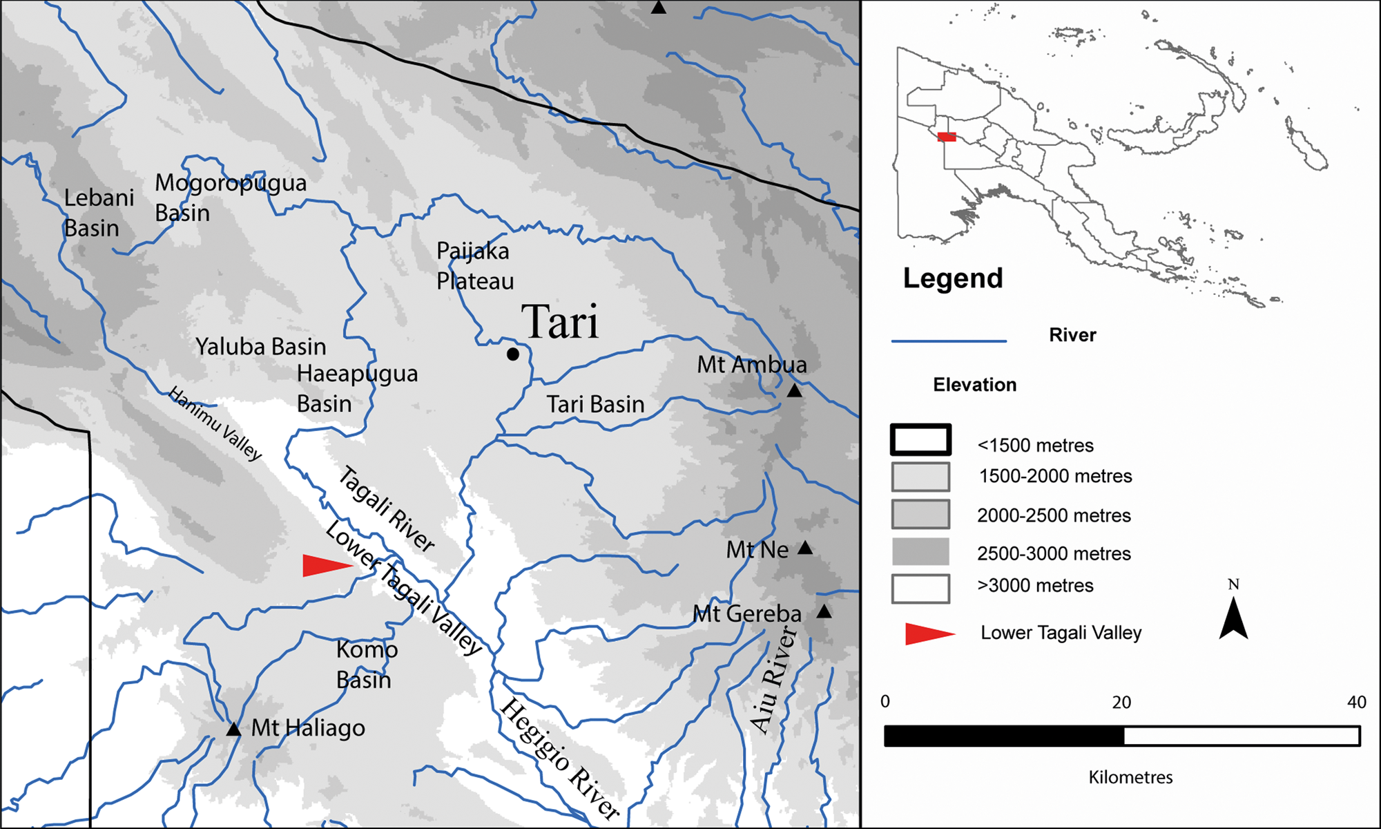
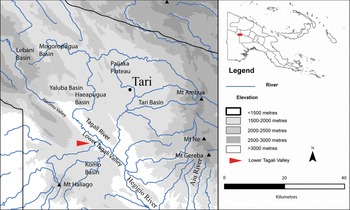
Map of the region occupied by Huli-speakers, showing key sites and geographical features.
A handful of earlier studies have probed the ethnoarchaeological potential of house structures in New Guinea: Sue Bulmer's (Reference Bulmer1976) pioneering excavation in the Highlands was of a recent house structure at Yaramanda; Edward Harris (Reference Harris1977) excavated a multiperiod occupation site comprising sequential house structures at Hed Mound in Kuk Swamp, with other house structure excavations occurring on the wetland margin (see Golson Reference Golson, Golson, Denham, Hughes, Swadling and Muke2017; also Lewis et al. Reference Lewis, Denham and Golson2016); in collaboration with ethnographer Edward Schieffelin, Mary-Jane Mountain (Reference Mountain1979) excavated a ritual hunting lodge in Kaluli territory, which had been built and used within living memory; Paul Gorecki (Reference Gorecki1985; Reference Gorecki, Gorecki and Gillieson1989) excavated former house structures along wetland margins in the Wahgi Valley and also observed and mapped ethnographic use of rock-shelters in the Upper Yuat Valley; Anick Coudart (Reference Coudart, Latour and Lemonnier1994) mapped 126 Angan houses to provide an axis of comparison for her analysis of Neolithic house structures across central Europe; Pierre and Anne-Marie Pétrequin (Reference Pétrequin and Pétrequin2006) mapped and described a range of house structures across West Papua, and the disposition of various artefacts within them; and Paul Sillitoe (Reference Sillitoe2017) describes the excavation and interpretation of a family house structure in Wola territory in the Southern Highlands.
Our investigations focused on the southern ridge (1700 masl) of the Lower Tagali Valley, some 30 km southwest of the current administrative centre of Tari and the major population centres in the central Tari and Haeapugua basins. Archaeological surveys (including cultural site mapping), test excavations and open-area excavations led by Ash and Denham, with Crouch for some sites, were undertaken over eight weeks during 2010, following cultural site mapping led by Muke in 2009. Of the range of archaeological investigations conducted, summaries of excavations at only two sites are presented here: a women's house (Huli: wandia) structure at Ketereanda and a bachelor cult house (ibagiyaanda) complex at Agala Tigi. These excavations bear directly on the history of Huli colonization of the Lower Tagali region over the last few hundred years, both in terms of settlement and the process of cultural enclosure of the landscape. Ethnographic observations and documentation of oral traditions derive from the available literature as well as fieldwork by Ballard in the Huli region between 1988 and 2006.
The Huli
Huli territory is generally accepted by government administrators and neighbouring ethnic groups to encompass lands from Komo Basin in the south, Paundaka to the east, the Paijaka Plateau to the north and the Mogoropugua and Lebani Basins to the west (Fig. 1; Ballard Reference Ballard2002, 8). While the lands of Huli-speakers are fixed in some senses, Huli geographies may more meaningfully be understood in terms of a Huli-centric worldview where ‘Huli stood at the center of a polyethnic trade network’ (Biersack Reference Biersack and Biersack1995, 9; see also Ballard Reference Ballard1994; Frankel Reference Frankel1986, 16–17; Mangi Reference Mangi1988). Information, materials and ritual knowledge have spread outwards from this Huli heartland over at least the last 200 years, often accompanied by progressive colonization and incorporation of neighbouring groups.
Huli oral histories are detailed and typically possess exceptional time-depth, extending back with confidence over at least two centuries, and, in some cases, to over twenty generations of genealogical depth and to events in the seventeenth century (Ballard Reference Ballard1995, 53; Reference Ballard, Goldman and Ballard1998; Reference Ballard2001, 291; Reference Ballard, McGrath and Russell2022a; Wood Reference Wood1984, 84). These oral histories are a valuable political and social resource because they document land ownership and events, including Huli migration outwards from the conceptual homeland of Huli speakers in the southern part of the Tari basin (referred to as huli ore, ‘very’ or ‘true’ Huli) into surrounding valleys and basins, including the Lower Tagali area (Ballard Reference Ballard2002, 9). History is ever-present in Huli landscapes: vegetation clearings, ancestral houses, ritual and garden plots and deep linear ditches known as gana each help to locate Huli speakers in the landscape and serve as enduring physical markers of an emplaced Huli presence. Gana, for example, delineate land-holding parcels, channel the flow of people and pigs across the landscape and demarcate both male and female spaces and ritual enclosures or sacred sites (Ballard Reference Ballard, McNiven and David2022b). People are intimately familiar with the ancestral biographies of these ditches, including who first dug them and when those people arrived in an area. Indeed, knowing how landscapes came to be (for example, which ancestor figure first cleared and enclosed a garden plot) is key to an individual knowing their place in the landscape and potentially articulating a claim to it.
Huli social structure has been described as cognatic or ambilineal, but largely follows principles of patrilineality and patrilocality (Glasse Reference Glasse1968; Goldman Reference Goldman1983). Non-agnates can be incorporated into a group through various mechanisms, enabling Huli men, in particular, to maintain residences in multiple clan territories or parishes (Allen Reference Allen and Biersack1995). A powerful ideology of gender separation and complementarity formerly divided the landscape into almost discrete male and female spaces, with separate housing, gardening spaces and access routes (Powell with Harrison Reference Pétrequin and Pétrequin1982; Wardlow Reference Wardlow2006). This gender ideology was formerly taught to male youths through a bachelor cult (ibagiya or haroali) which required a lengthy period of seclusion, often in lodges (ibagiyaanda or harolianda) set within primary or reconstructed forest on the margins of a clan's territory (Frankel Reference Frankel1986, 55, 103-4; Glasse 1968, 42 n. 1; Goldman Reference Goldman1983, 235–44).
The foundational myth of the ibagiya bachelor cult of the Huli in the southern lowlands describes the trajectory of one or more spirit women from origins in the southern lowlands, moving northwards via Lake Kutubu to the territory of Enga-speakers, north and east of the Huli. The purifying elements of the Huli ibagiya cult necessary for the production of bachelors, including water and other fluids, as well as the bog iris plant (iba wiliaba), were understood to derive from the body of this spirit woman (Frankel Reference Frankel1986, 99; Goldman Reference Goldman1983, 325–6), and Huli would periodically travel to Enga territory to replenish their stock of these materials. The Huli ibagiya cult resembles the bachelor cults of the Enga (Wiessner & Tumu Reference Wiessner and Tumu1998, 215–44), but also reflects local ideas about the potency of ideas and substances introduced from external sources. Deployed within Huli clan parishes, ibagiya bachelor lodges, consisting of a bachelor house set within a forested grove (tigi), demarcated a heightened gendering of space; but on the outer margins of Huli territory, these same lodges marked the expanding boundaries of Huli identity.
On a larger scale, Huli historical narratives of colonizing expansion and cultural enclosure of the landscape are focused heavily on the actions of male ancestors, their ideologies and rituals. Although some Huli expansion has been achieved directly through armed conquest, the inexorable processes of intermarriage, incorporation and assimilation have been equally as important, especially along the margins of Huli-speaking territory. Huli practices that effectively absorb neighbouring groups and territories are often deliberate and prepared for long in advance, but can also reflect the domino effect of competition in the richest environments, along the wetland margins in the major valleys of Tari and Haeapugua, which pushed refugee groups outwards and ultimately into the territories of non-Huli-speaking neighbours.
During the period of our excavations (between February and June 2010), Huli were actively engaged in extending their influence and territorial claims towards Juha in the southwest and Lake Kutubu in the southeast. Surveys along potential natural gas pipeline corridors from the Lower Tagali Valley to Lake Kutubu established a regular pattern of decreasing range of site categories with distance from established Huli areas (Ballard Reference Ballard2005). Not surprisingly, there were no major ritual centres (gebeanda) memorializing the presence of ancestors along these new frontiers; instead, the dominant Huli ceremonial sites found in recently settled areas were bachelor cult lodges (ibagiyaanda). Distinctive Huli-style houses, ditches, fences and gateways have now been established well within the territory of Foi and Fasu speakers around Lake Kutubu. Landscape modification in this way is evidently a critical marker of Huli territorial ambitions, and the establishment of bachelor cult centres is a crucial ideological claim and first step in the colonization process.
Archaeology in the Huli heartland: the Ipomoean revolution and Huli frontiers
Multiple lines of evidence reveal a long tradition of local environmental changes linked to phases of population expansion and displacement in the Huli heartland (Ballard Reference Ballard1995; Reference Ballard2001; Reference Ballard2002; Haberle Reference Haberle and Hather1994; Reference Haberle1998). Palaeoenvironmental records from the Haeapugua (1650 m) and Tugupugua (2300 m) basins reveal the opening of the lower montane forested area c. 21,000 years bp: a landscape-wide signal that followed the arrival of small groups of foragers burning and disturbing tracts of the forests as they ventured into the montane valleys in the region (Haberle Reference Haberle1998; see also Haberle Reference Haberle and Hather1994).
Horticultural activity during the mid–late Holocene probably focused on the swampy basin floors in the Tari and Haeapugua basins, although this may also be a product of better archaeological preservation. Swamp forest conditions developed c. 8500 years bp, with pollen records indicating episodes of more persistent clearance in Haeapugua from at least 1700 years bp and in Tugupugua within the last 700 years (Haberle Reference Haberle1998, 20). This latter date for the phase of swamp forest clearance in the higher basin is significant because it ‘may be linked to the upward expansion of human populations in response to the introduction of sweet potato into the highlands, allowing crop production to be practised at altitudes greater than 2000 m’ (Haberle Reference Haberle1998, 20).
Ballard (Reference Ballard1995; Reference Ballard2001; see also 2002) conducted archaeological and ethnographic investigations of wetland reclamation and population dynamics in the Haeapugua Basin of the Huli heartland. Three successive phases of wetland reclamation along the swamp margin expanded horticultural practices from 2500 to 2000 cal. bp (Phase 1), from 1300 to 1000 cal. bp (Phase 2) and from 600 to 200 cal bp (Phase 3). The most recent phase was explicitly linked to the introduction of exotic cultivars across the Central Highlands, in particular sweet potato (Ipomoea batatas).
The transformations in many Highlands societies initiated following the widespread adoption of the sweet potato within the last few hundred years have been described collectively as the ‘Ipomoean Revolution’ (after Watson Reference Watson1965; see Gaffney & Denham Reference Gaffney, Denham, McNiven and David2021). Among the consequences of this revolution are dramatic increases in human and domesticated pig populations, increased social inequality, the rise of ‘big men’ systems of leadership and the elaboration of extensive networks of ceremonial exchange (Modjeska Reference Modjeska and Strathern1982). In the Huli context, these changes were manifested in intensifying land-management practices in the wetlands, amplification of agricultural outputs and, notably, a considerable radial expansion of Huli settlements from the central Tari Basin toward more ‘marginal valleys and dryland upslope environments’ (Ballard Reference Ballard2002, 9). Comparable expansions from montane valleys into more marginal areas at both higher and lower altitudes have been recorded across the Highlands (Dornstreich Reference Dornstreich1973; Morren Reference Morren1986; Vayda Reference Vayda1971; Wagner Reference Wagner1971; Wohlt Reference Wohlt1978).
Huli genealogical histories, documented both in the Lower Tagali and Komo valleys as well as in the Tari Basin, indicate that the early nineteenth century, perhaps from around 1810 ce, was a period of major demographic, social and political reconfiguration. In a closely documented history, a number of resident groups in the eastern Haeapugua basin were displaced from the fertile wetlands in a series of conflicts with the powerful Tani phratry (a Huli phratry is a loose alliance of putatively related clans). Individual sub-clans and families displaced by the Tani clans sought refuge in the Koroba and Mogoropugua valleys to the north and west, but ‘most of the members of these clans fled in the one direction that still offered substantial space for refugees, towards the Lower Tagali Valley and the Komo Basin’ (Ballard Reference Ballard2009, 3).
Ballard's (Reference Ballard1995; Reference Ballard2001) study of wetland reclamation and population dynamics in the Huli heartland over the past 2500 years, and particularly over the past few hundred years, raises significant questions regarding the archaeological visibility of the processes of migration, diaspora and colonization in the Highlands during the late Holocene. Previous archaeological and palaeoenvironmental research into Huli prehistory has focused on the Huli heartlands of the Haeapugua and Tari basins. Few or no subsurface archaeological studies have been undertaken of potential refugee areas—the marginal valley systems and upslope dryland areas characteristic of the Lower Tagali area, excepting cursory surveys at Mogoropugua. Consequently, little is known materially about Huli processes of colonization and expansion into neighbouring landscapes.
Huli and Duguba in the Lower Tagali area
The Mananda [Komo] people are Huris (or Hulis) and there is no doubt that they all migrated from the Tari area … Group names at Mananda indicate a mixing of many run-away groups from east of the Tagari River. (Komo Station Patrol Report 1 for 1961–62, 9)
Along with the Komo Basin immediately to its south, the Lower Tagali area appears formerly to have been the territory of non-Huli groups known collectively to Huli as the ‘Duguba’. Huli neighbours on the lower-lying Papuan Plateau to the south, such as the Onabasulu, Etoro and Bedamini, are recognized today in Huli language as Duguba (Weiner Reference Weiner1988), but the term is also used to distinguish those Huli-speaking clans who claim some measure of descent from the original Duguba inhabitants of the Komo region and the Lower Tagali Basin (Main Reference Main2020). Genealogies and oral traditions of the key clans in the Lower Tagali area suggest that the migration of significant numbers of Huli-speakers to these traditionally Duguba lands began approximately eight generations ago, from about the beginning of the nineteenth century. Gradually, existing Duguba occupants became absorbed within Huli society, intermarrying and adopting Huli language and culture, with their ultimate Duguba origins recalled only in genealogies and clan names.
In oral histories, the two key Huli clans in the Lower Tagali region are the Taguali (of Huli origin) and the Tagobali (ultimately of Duguba origin). While the Taguali and Tagobali are now culturally and linguistically indistinguishable, ancestors of the latter include non-Huli-speaking Duguba with long-term roots in the region. Evidence for pre-Huli occupation by Duguba in the broader Komo region derives from oral traditions and genealogies. The ‘Huli Duguba’ of today were probably related to the Etoro and Onabasulu of the Papuan Plateau, to whom the Huli Duguba phratries or clan clusters Wara and Aya are putatively related, while a third Huli Duguba phratry, Bebe, derives from Bedamuni-speakers of the Juha region to the southwest (Allen & Frankel Reference Allen, Frankel, Schieffelin and Crittenden1991, 95; Ballard Reference Ballard2009, 1). Each phratry contains multiple clans, with Wara phratry including Alo, Daga, Hana, Kayumba, Kuara, Lebe, Mabulu, Mina, Pade, Paraya and Ware clans, and Aya phratry covering the Homani, Tagoria, Tagobali and Tobe clans (Ballard Reference Ballard2009, 1). The Taguali clan is held to have emigrated from Koroba in the north some eight generations ago, establishing settlements in previously uncultivated forested areas in the Lower Tagali area, in territory previously occupied by, and at the invitation of, the Duguba Nguane clan. This last colonization event may be captured in our archaeological excavations.
Field investigations
Field investigations focused on a 500 ha parcel of land on the western ridge of the Lower Tagali Valley, some 500 m above the valley floor (Fig. 1). The area is predominantly covered in a mixed montane forest, though some tracts have been cleared for gardens and settlement. Settled and gardened areas are located within patches of grasslands on the upper, mid-slopes and swales of the gently undulating plateau; they are surrounded by patches of primary and secondary forest. Most of the sites identified during initial surveys, some of which were subsequently excavated, were known to and named by local residents. People knew these sites as cultural places because they were known in oral tradition, encountered during ground-disturbing activities such as gardening and ditch-digging, identified on the basis of the presence of particular plants or tree species signifying former settlements and ritual sites, or marked by abandoned gana ditches that serve to enclose and partition social space. The two sites reported here—Agala Tigi and Ketereanda—were known as past settlement places and each was occupied until very recently, within one or two generations. Ketereanda is located on an exposed ridge top overlooking a cleared valley and Agala Tigi within a ritually managed grove (te) of trees.
Initially, two test units were excavated at each site, measuring 0.5×0.5 m at Ketereanda (Site Code 323, Squares A and B) and 1.0×1.0 m at Agala Tigi (Site Code AT1, Squares A and B). These excavations were exploratory and designed to provide an indication of sub-surface archaeological remains and high-resolution vertical control through the stratigraphy. Excavation units, or spits, averaged 2–3 cm and upwards of 7 cm in culturally sterile deposits and were excavated within stratigraphic units. Charcoal and macrobotanical samples were collected in situ for radiocarbon dating. All excavated materials were collected and sieved. Initially, all excavated material was dry-sieved through a 2.1 mm mesh; however, dry-sieving proved impossible given the compact and moist, clay-rich stratigraphy. A temporary wet-sieve facility was subsequently constructed. All collected materials were transported for detailed laboratory analysis to the AQIS (Australian Quarantine and Inspection Service) approved archaeological facilities at Monash University, Melbourne, Australia.
The stratigraphic profiles at both sites were similar and consistent with oxic soil profiles developed on a highly weathered, volcanic substrate. SU1 was a loose and friable, black-to-very dark brown (10YR 2/1–2/2) topsoil (upper 1–2 cm). SU2 was a compact and consolidated, dark brown-to-black (10YR 2/2–10YR 2/1) clay loam extending to between 14 and 24 cm below ground surface. SU2 was slightly different in colour (including black, 7.5YR 2.5/1), more organic-rich and charcoal-laden at Agala Tigi. SU3 was a compact, dark yellowish brown-to-brown (10YR 4/4 and 4/6–10YR 4/3 and 3/3) clay, which was considered culturally sterile with respect to the investigation of Huli settlement. The three stratigraphic units are referred to here as A (SU1), B (SU2) and C (SU3) soil horizons. A mottled and inter-mixed zone between SU2 and SU3 was 6–12 cm in thickness and represented pedoturbation between the two layers.
During open area excavation, SUs 1 and 2 were stripped using shovels and hand-trowels to expose artefacts and features at the interface between SU2 and SU3, namely to delineate SU2-filled features against the underlying SU3 clay surface. The uppermost edges of features thus exposed could have a higher originating stratigraphic provenance within SU2, but any cuts and fills were indistinguishable within SU2. The fills of features exposed against the SU3 substrate were then half-sectioned and excavated material sieved. Additional areas with dense cultural material were excavated by hand trowel and excavated material was sieved. Archaeological recording adopted single-context recording systems for open-area excavation (Roskams Reference Roskams2001).
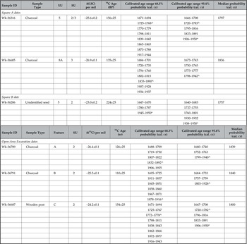
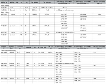
A total of 16 AMS dates are reported for the two sites (Tables 1 & 2). For ease of interpretation, radiocarbon dates are discussed using median calibrated date probabilities rounded to the nearest 25 years (ce) (after Telford et al. Reference Telford, Heegaard and Birks2004). Only the structural elements recorded at each site are detailed here; fuller results of the archaeobotanical, palaeoecological and lithic analyses, along with detailed descriptions of the stratigraphy and excavations, are forthcoming.
AMS date estimates for the house site at Ketereanda. Calibrations use Calib 8.2 and IntCal20 (Reimer et al. Reference Reimer, Austin and Bard2020). Radiocarbon age estimates were obtained on single pieces of organic material. (key: ̂ highest probability range; * influence of nuclear testing).
AMS date estimates for the ibagiyaanda at Agala Tigi. Calibrations use Calib 8.2 and IntCal20 (Reimer et al. Reference Reimer, Austin and Bard2020). Radiocarbon dates all derived from single pieces of wood charcoal (key: ̂ highest probability range; * influence of nuclear testing).
House structure at Ketereanda
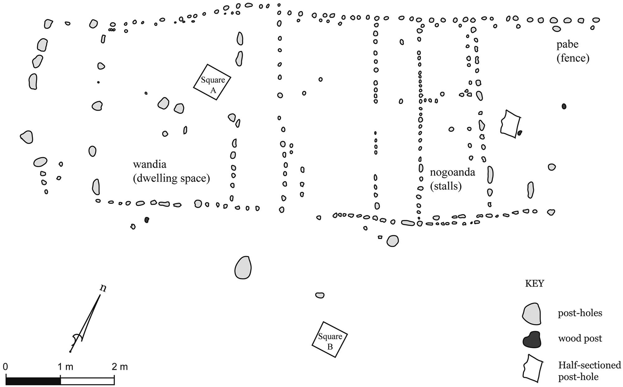
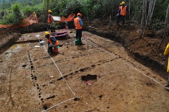
The former house site is located on a partially cleared ridge-top thickly vegetated by various grass and small tree species. The site is located upslope from a complex of mound-and-ditch gardens on a small valley floor and at the interface with a patch of montane forest. Huli genealogies and oral histories suggest this site was a men's house (balamanda). The location for the exploratory excavation squares (Squares A and B) were chosen at the recommendation of Huli participants, who observed grass species frequently associated with domestic dwellings (Imperata cylindrica and Miscanthus floridulus) and a gana used to demarcate Huli dwellings from forested areas. Subsequent open-area excavation exposed 263 post-holes of a rectangular structure against the underlying SU3 surface (Figs 2, 3). Some post-holes contained remnant wood fragments of the original post, suggesting a relatively recent age.
Plan showing features of the house structure at Ketereanda exposed against Stratigraphic Unit 3.
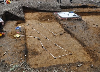
Excavation and recording of house site in progress. Note the configuration of post-holes in the internal rooms. View from northeast. (Photograph: Jeremy Ash.)

The exposed post-holes revealed a symmetrical building arranged around a series of larger post-holes along a central longitudinal axis that demarcated up to seven internal spaces. The major entrance to the house was in the northeastern wall and defined by a series of large and thin post-holes (each measuring approximately 15×4 cm), some of which retained remnants of the wooden planks. A smaller though less clearly defined entrance was positioned along the southwestern wall. The two long external walls were built using two differently sized posts offset slightly from each other. The inner side of these walls are defined by regularly spaced c. 6 cm diameter posts, and a series of smaller c. 3 cm diameter posts generally infill the spaces between or are slightly offset to the external side of these larger posts. The larger posts were probably load-bearing, whereas the smaller were used to fix matting and brushwood for the external walls. Internal walls were constructed of smaller, circular posts (c. <6 cm diameter) to demarcate up to seven dwelling spaces including rooms and sleeping platforms. No fireplaces were found inside the structure, which is peculiar, given that men's houses (balamanda) and women's houses (wandia) typically possessed internal stone-lined fireplaces as well as external cooking pits (Powell with Harrison Reference Powell and Harrison1982, 10–29).
The upper surface of SU3 was likely to have been the old floor surface within the structure, because Highlanders typically strip the topsoil off a site before constructing a house. The small number of cultural items found during excavation, including fragments of wooden house posts, a broken stone adze and a few small chert pieces, were mostly recovered from this surface. Further, the floor surface had been moulded to create a topographical high point within the house along the central longitudinal of load-bearing posts. The floor surface gradually dips on either side of this line toward the walls. Internal moulding of the floor surface was probably designed to assist with microtopographical drainage of any surface water, directing it outside the structure. Shallow drains outside the house had been offset 20 cm away from the house's external walls to direct the flow of water falling off the eaves towards the gana.
The structure was organized into three main internal spaces (Fig. 3). The front of the dwelling was built with the typical flat planks, with large weight-bearing posts on either side of the entrance. The front space (hane) was separated from the central bedroom (habane) by a wall with large supporting posts. A third space at the rear of the structure was further sub-divided into four small rectangular spaces arranged on either side of a central space; these small rectangular spaces were interpreted by Huli field participants as pig-pens (nogo tamu) and the central space as a passage-way providing access/egress for domestic pigs to the large ditch (gana) to the rear of the structure. The organization of the dwelling into three main areas conforms with the observations of Powell with Harrison (Reference Powell and Harrison1982, 14) on Huli women's houses:
The traditional Anda Wandia was up to 7–8 m long and 3.5 m wide. It consisted of three rooms: a front room, ‘Hane’, a middle room with two to five pig pens along either side of a central passage-way, ‘Noku [nogo] tamu’, and a bedroom at the rear, ‘Habane’. This house style was abandoned as a result of pressure from the administration and missions who opposed the custom of living with pigs on the basis of hygiene.
Huli informants at Ketereanda suggested these small spaces were pig-pens, which are almost exclusively associated with women's houses, as women do much of the daily tending and feeding of much-prized pigs. Formerly, strict proscriptions on the entry of pigs into men's balamanda houses ensured that men's pigs were housed separately in pig huts (nogoanda). The inclusion of pig-pens within the Ketereanda structure might thus appear to contradict oral-historical knowledge of the site as the location of a men's house. However, it is common Huli practice to convert abandoned men's houses into women's houses, and women's houses into shelters exclusively for pigs (Powell with Harrison Reference Powell and Harrison1982, 9). Ketereanda may thus represent a process of initial clearance and establishment as the site of a balamanda men's house (which is what we would expect to find emphasized in oral traditions making claims to priority in the landscape), and subsequent conversion as the original house degraded, or the frontier of male settlement advanced, into a house for women and the pigs in their care.
The pig-pens or nogo tamu appear to have been located at the rear of the Ketereanda building (rather than the front or habane, as per Powell with Harrison Reference Powell and Harrison1982). A series of post-holes extends the sidewalls beyond the area enclosing the pig-pens at the rear of the structure, and appear to be a pabe [fence] directing pigs to the gana. It is also possible that post-holes enclosing this space denoting a habane [sleeping room] were missed during excavations. We suspect, however, that these post-holes relate to an external semi-enclosed porch, perhaps to house firewood (a feature not uncommon in Huli houses), or represent part of a pabe directing pigs to the gana at the rear of the structure. If this were the case, it would imply that, while Huli housing acted to regulate physical interactions between women and men through the careful discrimination of social space, there nevertheless existed some flexibility in the arrangement of internal space within traditional Huli women's houses. The specific arrangements within individual women's houses probably reflected considerations such as slope (with human space positioned upslope from the pig-pens) and access to gana ditches along which pigs were herded.
Six AMS dates were obtained on macrobotanical materials collected during excavation. Two charcoal samples and an unidentified seed from Squares A and B were intended to date the SU2/SU3 interface (i.e. the floor surface): Wk-36286 at the base of SU2; Wk-36316 within the SU2/SU3 mixed zone, and Wk-36685 within SU3 (Table 1). The dates are in reverse chronological order, which in hindsight is not surprising given that they all originate from within the upper 32 cm of the ground surface. These samples were all collected from within the zone of active pedogenesis, as suggested by the soil profile with A (SU1), B (SU2) and C (SU3) horizons. Comparatively ‘old’ or residual charcoal can be reworked within the A and B horizons, while comparatively young or intrusive charcoal can be introduced to the C horizon.
To resolve these chronological uncertainties, three features within the house structure were dated: charcoal in the fills of two post-holes (Wk-36789 and Wk-36791) and a wooden post from one of the largest and deepest post-holes (Wk-36687). All three dates are broadly consistent, given that the larger post may contain a slightly larger ‘old wood effect’. Taken together, the dates on features at the house site suggest it was built after 1800 ce and most likely at some point during the mid nineteenth century, shortly after c. 1840 ce.
Bachelor cult house at Agala Tigi
Local informants indicated that Agala Tigi was a training place for young bachelors readying to become haroali initiates in the haroali bachelor cult (also known as ibagiya or igiri more). The excavated site is one of three bachelor cult lodges (ibagiyaanda) that formed a ritual complex at Agala Tigi. Senior Huli informants noted that the ibagiyaanda was abandoned during the 1960s or ’70s due to the intervention of missionaries and as an outcome of the reconfiguration of Huli ritual practice in recent times following widespread conversion to Christianity.
The site is located on the western side of a low southwest–northeast oriented ridge within a forest known as te. Te are ritual groves of primary or secondary forest preserved to ensure the isolation of haroali from women and married men (Figs 4 & 5; Ballard Reference Ballard1995; Frankel Reference Frankel1986, 55). The defining spatial marker of ibagiyaanda is the encircling drain or gana, which separates the dwelling space from the enclosing bachelor cult grove (haroali tigi) dominated by oak (bai: Castanopsis sp.) trees. Oak and hoop pine (guraya: Araucaria cunninghamii) are highly significant tree species associated with ritually important ancestral sites (gebeanda) and carefully managed ritual groves (Ballard Reference Ballard1995, 44). The delineation of social space through the use of deep gana ditches or drains acted as the ‘primary physical means of the human inscription of space, of the creation of meaningful distinctions within the Huli landscape’ (Ballard Reference Ballard1995, 98).
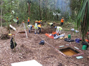
Initial clearance and open area excavation of ibagiyaanda at Agala Tigi. View to northeast. (Photograph: Lad Nejman.)
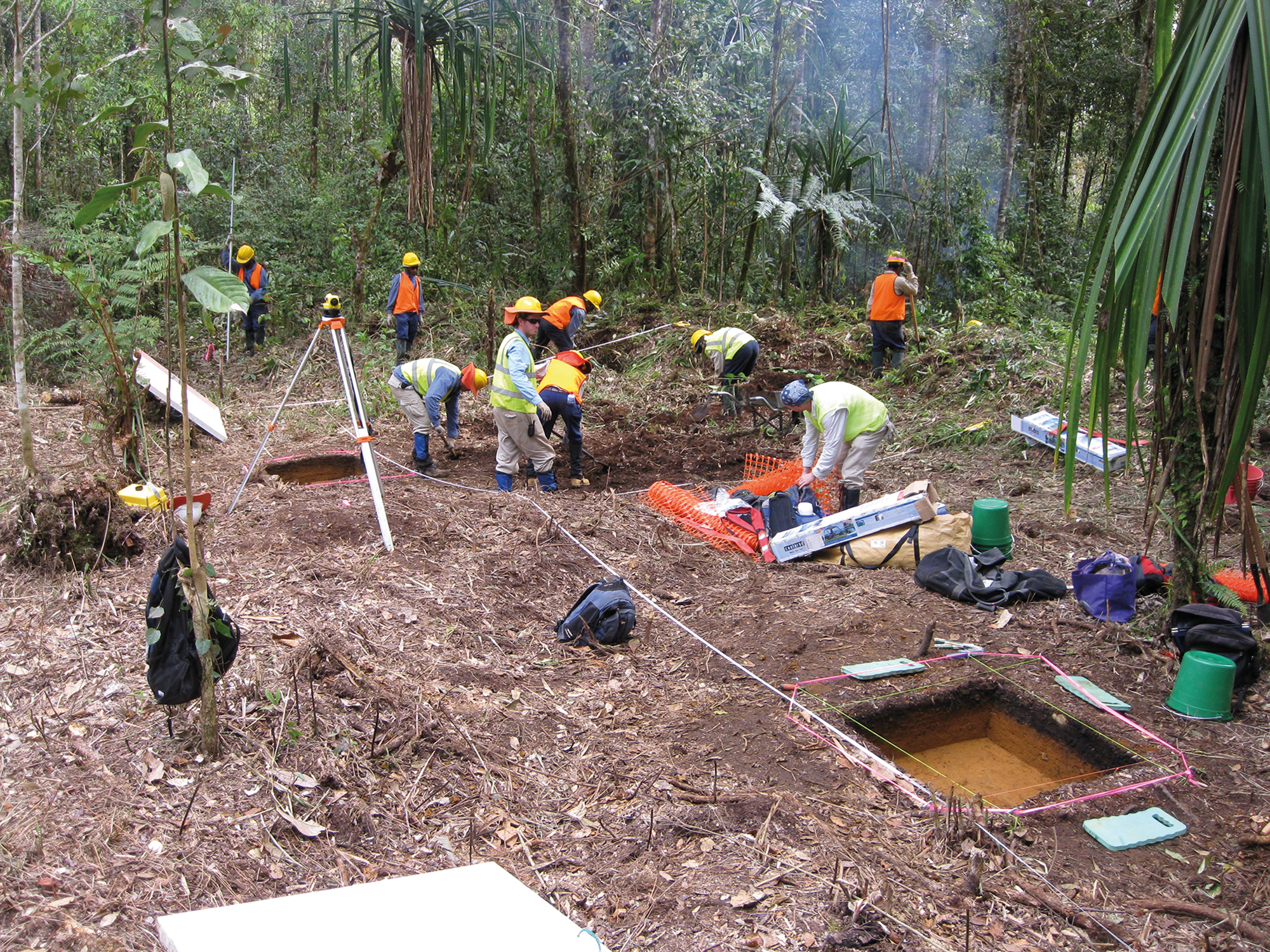
Open-area excavation of Agala Tigi in progress. The large surrounding trees are growing in the perimeter gana for the ibagiyaanda. The automatic level is located on the top of the earthen mound that bisects the enclosed area and transects the southern side of the circular ditch. This mound was part of the main entrance into the hidden complex. View to northeast. (Photograph: Joe Crouch.)

The boundary of the ibagiyaanda is defined by an impressive circular gana, measuring c. 80 m in circumference. During its construction, dug materials were piled up on the inner side of the circular ditch to create a raised bank (called the gana nene) measuring up to 2 m in height from the gana floor. Water drained out of the circular gana into a dedicated channel (iba hariga/tombeleda) at its northern end at the lowest part of the site (see Ballard Reference Ballard1995, fig. B18 for a cross-section of a gana and a description of its component parts). The inner circle of enclosed ground was divided into two halves by a raised earthen mound (Fig. 5). The mound is about 80 cm high and crosses the southern end of the circular gana to create the main entrance into the complex (the gana was in-filled at this point). Another entrance had been cut through the gana nene on the eastern side of the complex.
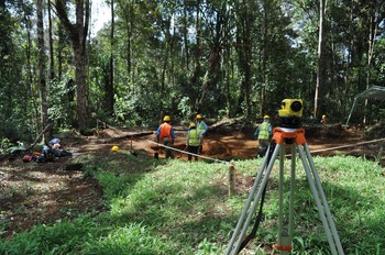
Open-area excavation focused on the northeastern quadrant of the complex (Figs 5–7), which was divided into three areas (NE1, NE2 and NE3); these were then excavated sequentially following the stratigraphy (SU1, SU2, and upper section of SU3). Field investigations ceased before mapping and excavation were complete due to social instability in the region. Fig. 7 is a schematic of exposed features and excavation areas in the northeastern part of the complex.
Arrangement of post-holes within area NE1 of the ibagiyaanda. View to east. (Photograph: Lad Nejman.)

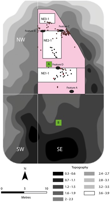
Schematic of ibagiyaanda at Agala Tigi, showing topography and the locations of excavation areas (green, pink and white boxes), post-holes (black circles), hearths (Features A to D) and stone artefacts (red circles).
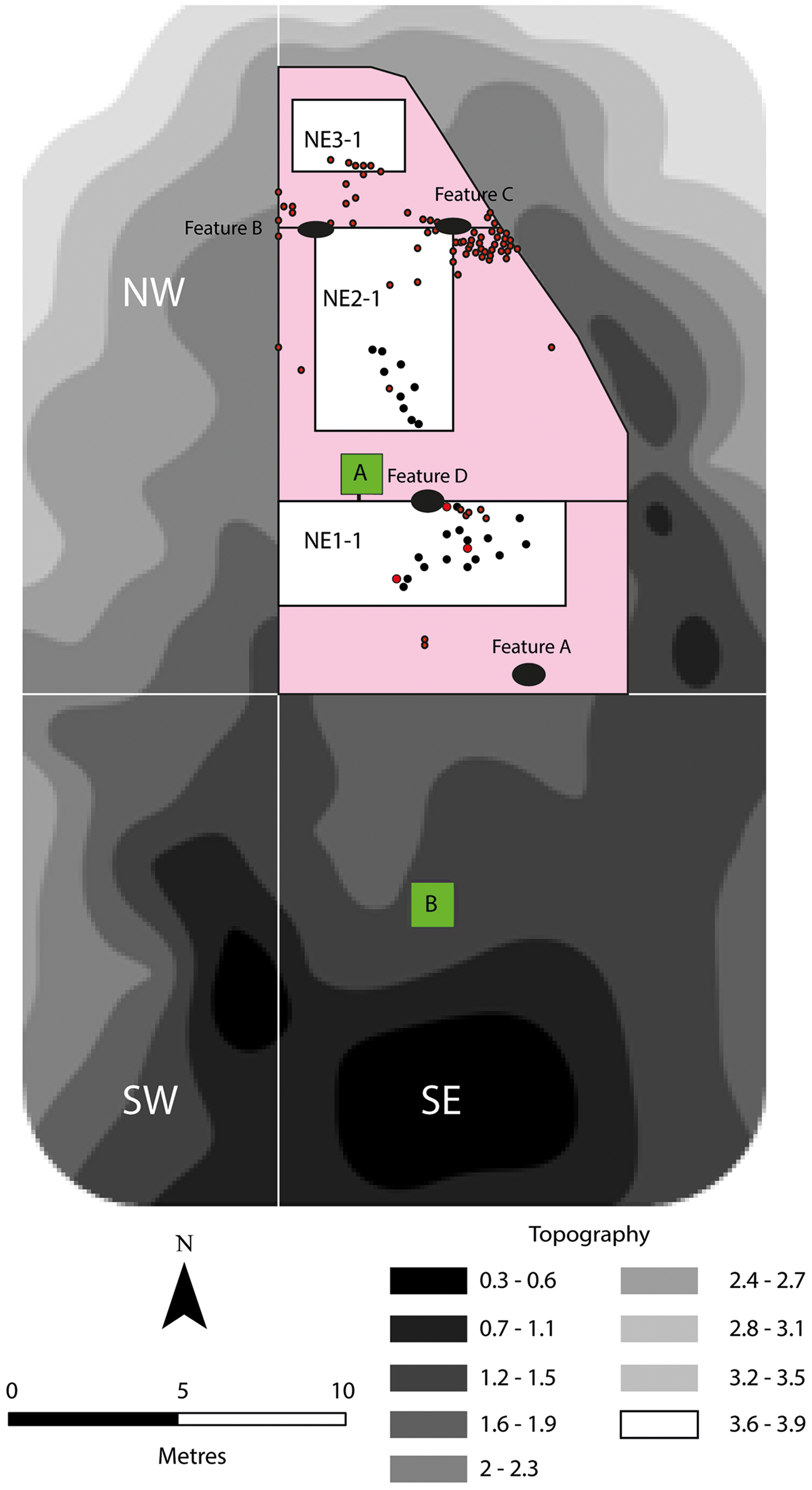
Although incomplete, excavations permit an intimate portrait of life within the ibagiyaanda. The excavations revealed 25 post-holes associated with two abutting walls, perhaps two former structures (a building wall or fence), neither of which was completely exposed by excavation. The series of post-holes is essentially linear, though the post-holes themselves are irregularly spaced, suggesting multiple rebuilding events in the same footprint. Five hearths with associated cooking stones were also uncovered.
The post-hole configuration and superimposed features at the ibagiyaanda suggest that the complex was constantly being rebuilt and its internal space renewed. The post-holes uncovered in NE1 and NE2 imply multiple superimposed and rebuilt structures (whether buildings, fences or palisades), and one of these post-holes transects, and thus postdates, a hearth—the hub of life within the complex. Indeed, one of the first tasks for new haroali initiates was to rebuild houses and fences within the ibagiyaanda (Frankel Reference Frankel1986). This exercise would have involved the removal or cleaning of topsoils to expose the underlying clay layer (here, SU3) and thus would have resulted in the continual reworking of soils and remaking of perishable structures with each new cohort of haroali initiates.
More than 400 flaked stone artefacts were collected. The stone artefacts were predominantly of different sorts of chert, and comprised 386 unipolar and bipolar small flakes and flaked pieces and bipolar (n = 16) and unipolar (n = 4) cores, suggestive of on-site flaking activities. Three broken ground stone axe-adzes typical of the planilateral axe-adzes common in western Highlands sites were also found (see White Reference White1972, 6). The artefacts cluster around hearths outside structures of the ibagiyaanda (Fig. 7; see also Powell with Harrison Reference Powell and Harrison1982, 10ff). The detailed lithic study and results of a use-wear and residue analysis are forthcoming. An absence of knapping debris within structures, also noted at the house structure at Ketereanda, is expected because it would generate numerous sharp lithic debitage within spaces used for sitting and sleeping (see Sillitoe & Hardy Reference Sillitoe and Hardy2003 for further discussion regarding such discard patterns evident in Highlands ethnoarchaeology).
Ten AMS radiocarbon dates were obtained for the ibagiyaanda (Table 2). Three samples were intended to date the stratigraphy, focusing on the SU2/SU3 interface (an unidentified seed, Wk-36284) and the uppermost level of SU3 (individual pieces of charcoal, Wk-36314 and Wk-36315). The remaining seven dates, all on individual pieces of charcoal, targeted different features within the complex. Wk-36683 provided an anomalously old date on presumably residual charcoal collected from SU3 sediments around the hearth in Test Square B, rather than from the fill of that hearth itself (dated by Wk-36357). Four samples could not be calibrated: one returned a modern date, and three others were too recent to register on the IntCal20 calibration curve. Except for the older anomalous date, all radiocarbon dates post-date 1750 ce.
The ibagiyaanda was potentially first established around 1750 to 1800 ce. A subsequent period of use during the mid nineteenth century, shortly after c. 1840 ce, is contemporaneous with the house site at Ketereanda. The very recent dates complement the oral testimony of local informants, showing that the ritual complex was still in use and probably repeatedly rebuilt up until the recent past.
Huli frontier expansion and bachelor cults
Two settlement sites were excavated within the Lower Tagali Valley area: a woman's house or wandia at Ketereanda, and the bachelor cult lodge or ibagiyaanda complex at Agala Tigi. The general chronology and character of these archaeological findings in this area south of the Huli heartland are significant because they broadly correspond to oral traditions that suggest Huli expansion into these areas had occurred eight generations ago, namely by the mid nineteenth century (Ballard Reference Ballard2009). The colonization process is likely to have occurred in two stages: initial pioneering settlement and cultural enclosure of the landscape, followed by more established housing and gardening.
The excavations of the ibagiyaanda complex extend ethnographically known Huli bachelor cult practices as far back as 1750–1800 ce, with periodic reworking of the enclosure during the mid nineteenth century and up to the recent past. Furthermore, these findings provide material insights into the processes of Huli migrations from the cultural and cosmological heartland of the Tari and Haeapugua basins (Ballard Reference Ballard2002). In Huli traditions, the introduction of the bachelor cult from Engan groups to the north and east occurred during the human and not the earlier spirit era, but still distantly in time. The older time period for establishment, based on a date (Wk-36688) collected from a hearth feature from within the ibagiyaanda, probably coincides with the earliest Huli forays into the area, potentially by haroali initiates operating on the frontier of Huli territory.
The main structural elements recorded within the ibagiyaanda complex comprise post-hole alignments suggestive of house structures, although possibly associated with fences or walls. These post-date some hearths and were most likely constructed from the mid nineteenth to early twentieth centuries. This antiquity corresponds to the house at Ketereanda, most likely built during the mid nineteenth century; these are the earliest secure radiocarbon dates from our excavations in this landscape and probably represent the first major Huli settlement of this landscape.
Excavations of the women's house at Ketereanda shed further light on the spatial logic underpinning and reinforcing Huli settlement practices. This site was selected for excavation based on information provided by a senior Huli field participant and landowner. He knew of the site as a balamanda [men's house] on the Ketereanda ridge-top occupied by one of his wife's ancestors two generations previously. As the structure's shape was exposed during excavation, it became clear that we had instead exposed a different Huli house type that was not previously known to be associated with this part of the landscape—a women's house (wandia). As proposed above, it is entirely possible that the initial construction was a men's house, memorialized as such in oral tradition, which was subsequently converted into a house for women and their pigs.
Although the division between male and female dwelling spaces is now less strict, the shift in the interpretation of the Ketereanda house site—from that of an ancestral balamanda to a wandia—was not inconsequential to local people. Though the findings were unexpected to local informants, the excavations were undertaken with a distinctive archaeological sense of discovery that comes with digging and exposing buried cultural traces from the ground (see Urwin Reference Urwin2019). The presence of a familiar Huli structure from beyond living memory at Ketereanda reinforced a sense of the depth of Huli presence in the Lower Tagali Valley landscape.
While the symbolic and political significance of rebuilding houses at the same location has been highlighted previously, for example, as ‘part of a complex ideology that serves to localize a social group’ (Gillespie Reference Gillespie, Joyce and Gillespie2000, 16), open-area excavation of the Ketereanda house, in concert with ethnographic site (re)interpretation, appears to document an episode of re-use in which the localized division between male and female dwelling space has been reconfigured in line with an expanding frontier of colonization.
It should be stressed that Huli expansion into areas formerly occupied by non-Huli populations rarely entailed wholesale displacement of those existing populations. More commonly, they were incorporated through ritual, marriage and other forms of exchange, to the point where they spoke Huli and performed as Huli, even as they retained a historical identity of non-Huli origins. The occupants of the Ketereanda house may still have thought of themselves as historically ‘Duguba’, but they had become almost certainly indistinguishable, materially and archaeologically, from Huli.
Conclusion
In summary, the earliest use of the ibagiyaanda complex at Agala Tigi may represent early forays by haroali initiates into the Lower Tagali landscape. Around 1750–1800 ce, these valley slopes were on the periphery of Huli territory, sparsely settled by Duguba populations and carpeted in forest. However, the ritual incursion into this landscape began a process through which the area was ideologically and then physically incorporated into Huli territory. By the time the main structural elements were constructed at the wandia at Ketereanda and the ibagiyaanda at Agala Tigi, shortly after c. 1840 ce, Huli occupation of the Lower Tagali Valley was sustained and largely complete. Although these excavated sites cannot be uncritically assigned to ‘Huli’ or ‘Duguba’, it is compelling evidence for intensifying occupation of the Lower Tagali landscape that corresponds closely to Huli genealogical histories for a southward migration some eight generations ago.
Acknowledgements
Our sincere thanks to our landowners and clans of the Lower Tagali landscape. Tim Denham and John Muke co-directed the archaeological field investigations as a whole, while Jeremy Ash with Joe Crouch directed the excavations documented here. The authors acknowledge and thank the field team for their contributions and good humour: Amenaia, Pape Ayule, Sharka Berry, Alana Colbert, Andrew Costello, Alex Elawi, Wandipe Hawi, Patrick Henry, Ibaria, Kevin, Ekalia Liya, Matialu Matin, Simon Matthew, Les Muke, Ladislav Nejman, Olabe, Kum Seka, John Sepe, Ben Shaw, Kendari Thomas, Gibson Topi and Lemon Tumuku. This project was conducted as an archaeological salvage project associated with the PNG LNG natural gas project. We extend our gratitude to project staff for logistical support, and to staff at the Papua New Guinea National Museum & Art Gallery (NMAG), in particular to the late Herman Mandui, for support, advice and the relevant NMAG permits for fieldwork and archaeological laboratory analysis.


 Open access