

The economies of virtually all premodern state societies depended on complex systems of hydraulic agriculture. Innovations in both the technology and social organization of production underwrote the expansion and intensification of farming systems in these states, which often incorporated various types of irrigation networks and segmented field systems. Such systems were designed to optimize food production through subtle technological adaptations to locally diverse soil, water, nutrient, and climate regimes (Ertsen Reference Ertsen2010; Ortloff Reference Ortloff, Scarborough and Isaac1993, Reference Ortloff1995, Reference Ortloff2010, Reference Ortloff2020; Purdue Reference Purdue2015; Rost Reference Rost, Michel and Chemla2020). Many state networks of intensified crop production were accretional, often reconfigured from preexisting, smaller-scale systems. Understanding the design, structure, spatial configuration, and localized management of these systems yields insight into social processes of the intensification of food production, the technological expertise reflected in the construction of hydraulic networks, and, by inference, the demographic potential, provisioning limits, and nature of the state-level political economy afforded by them (Ertsen and van der Spek Reference Ertsen and van der Spek2009; Ortloff Reference Ortloff2019).
One aspect of the complex relationship between the construction and management of infrastructure and the development of state-level political administration is standardization in the form and organization of large-scale public projects, such as agricultural systems, road networks, and domestic residences. Standardization is a fundamental mechanism of coordination and control used by both ancient and modern states (Klochkov et al. Reference Klochlov, Papic and Butkevich2017; Russell Reference Russell2013; Scott Reference Scott1999; Scott and Bhatt Reference Scott and Bhatt2001). Standardization of social, political, and economic structures incorporates new groups into state procedures, facilitates intergroup transactions, configures corporate labor projects, and establishes structural and behavioral similarities among subject populations. James Scott (Reference Scott1999:2) studied premodern state mechanisms of incorporating new and different labor forces and how states employed standardized social practices, identities, and organizational forms to establish political control and to reduce the burdens of administration. We argue that a strategy of standardized, segmented agricultural fields was used by the Inka to increase and manage food production in the Jequepeteque Valley on the north coast of Peru, even though this specific project was never completely successful.
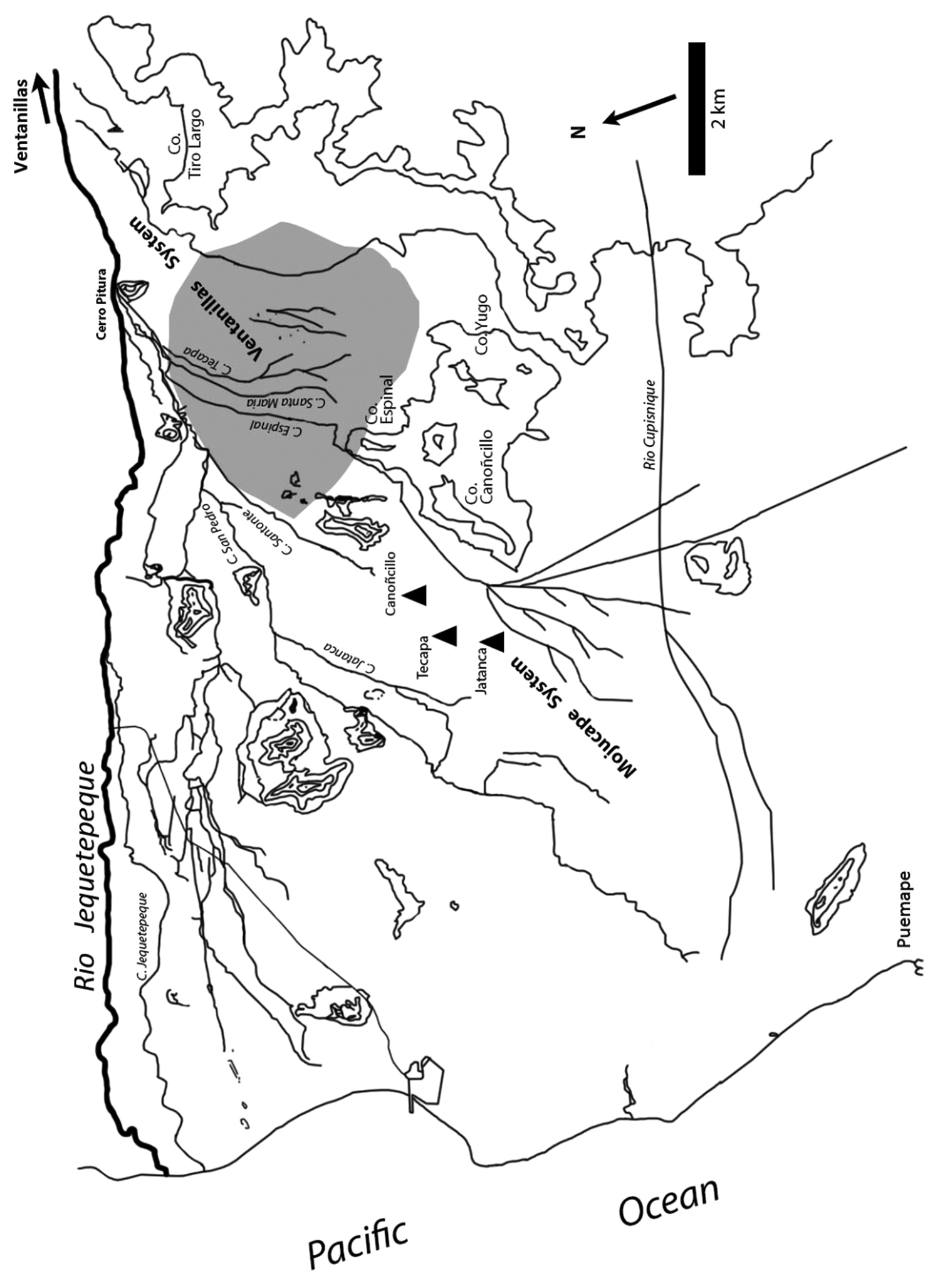
In this study, we examine a portion of the wider irrigation and agricultural field system in the Jequetepeque and Chaman Valleys that was first studied by Eling (Reference Eling, Matos M., Eling and Turpin1986, Reference Eling1987) and subsequently by Dillehay and Kolata (Reference Dillehay and Kolata2004a, Reference Dillehay and Kolata2004b; Dillehay et al. Reference Dillehay, Alan Kolata and Warner2009; see Figures 1–3). The Pampa de Guereque is a large, sandy, and rocky alluvial fan on the south bank of the Jequetepeque River that incorporates a standardized and segmented field system constructed by the Inka, most likely with mitimae (ethnic populations relocated from their natal homelands) and employing Chimú engineering knowledge that used an existing canal network continuously built and expanded from late Formative to Chimú times (~200 BC–AD 1100–1470). The combined Chimú–Inka canal-field system is among the most detailed and best preserved of its kind on the north coast of Peru, exhibiting clearly defined surface expressions that suggest comprehension of the purpose and full scope of the system. The segmented system is organized as contiguous, standardized, modular units fed by preexisting primary and secondary canal networks. It is the recursiveness in the standardized organizational form that, if completed and fully operational, would have facilitated the management and ease of food production.
Location of the study area in the Jequetepeque Valley (red dot) on the north coast of Peru (Google Earth). (Color online)

The study area on the south side of the Jequetepeque Valley, showing the Pampa de Guereque, the primary and secondary canals and other key features (modified from Eling Reference Eling1987).
Aerial location of the agricultural field and canal system in the Pampa de Guereque (Google Earth).

Before describing and analyzing this system, we first review some organizational principles of Chimú and mainly Inka state farming systems; we then present a case study of land use/land management instituted by the Inka emperor Wayna Qapac in the highlands of the Cochabamba Valley in Bolivia. Wayna Qapac's radical reorganization of agricultural lands in Cochabamba was studied by Nathan Wachtel (Reference Wachtel, Collier, Rosaldo and Wirth1982) who deployed archival records from the early Spanish colonial period in his analysis; he described the Inka state's reconfiguration of autochthonous settlements and land use into a series of elongated and segmented agricultural fields worked by mitimae brought in to displace local populations and work the land on behalf of the state. The Cochabamba system differs from the Pampa de Guereque network because it was a de novo Inka construction, rather than an accretional expansion of agricultural fields in an extant irrigation network. Moreover, the Cochabamba Valley Inka field system is documented from the Spanish archival record rather than from archaeological evidence, as is the case with the Pampa de Guereque. Despite these differences, Wachtel's analysis is instructive for suggesting ways in which this type of agricultural system was structured administratively and worked by imported laborers under Inka rule and for providing details on its segmented and standardized form.
As discussed later, the archaeological evidence of the Pampa de Guereque indicates that subjects under Inka rule designed and built the visible surface features of the agricultural field system. We know that the Chimú and Inka exercised both similar and dissimilar systems of administrative control over state projects in the valley (Mackey Reference Mackey, Malpass and Alconini2010, Reference Mackey, Zori and Johnson2011; Netherly Reference Netherly, Moseley and Cordy-Collins1990). The two states were similar in that both instituted direct control at the highest-ranking sites yet allowed local lords and their communities in the valley to have some degree of autonomy. Chimú management of local populations, irrigation networks, and food production appears not to have been as rigid as the Inka's, operating with a more consensual, collaborative approach in concert with local lords (Dillehay Reference Dillehay, Zori and Johnson2011; Dillehay et al. Reference Dillehay, Alan Kolata and Warner2009; Kremkau Reference Kremkau, Zori and Johnson2011; Mackey Reference Mackey, Zori and Johnson2011). Although the Inka often negotiated with local leaders regarding the administration of people and resources, they generally exercised more strict and systemized control at the highest levels of administration (Netherly Reference Netherly1984, Reference Netherly, Moseley and Cordy-Collins1990), making changes to local political economies and modifying their existing organizational infrastructures in ways that we are only beginning to more fully comprehend (Alconini Reference Alconini2008; D'Altroy Reference D'Altroy and Brumfiel1994; Farrington Reference Farrington, Downing and Gibson1974, Reference Farrington1977, Reference Farrington and Ravines1978; Garrido and Salazar Reference Garrido and Salazar2017; Hayashida Reference Hayashida2006; Kolata Reference Kolata2013; Kosiba Reference Kosiba, Alconini and Alan Covey2018; Kus Reference Kus1972, Reference Kus1980; Murra Reference Murra1980; Ramírez Reference Ramírez, Moseley and Cordy-Collins1990; Stehberg et al. Reference Stehberg, Sotomayor and Cerda2016).
As part of the process of mediating between state and local actors, the organization of the Inka Empire often was drawn along similar lines to those reflected in the internal organization of subordinate polities and once-independent states, such as that of the Chimú (Conrad Reference Conrad1977; Netherly Reference Netherly, Moseley and Cordy-Collins1990; Rostworowski de Diez Canseco Reference Rostworowski de Diez Canseco1988, Reference Rostworowski de Diez Canseco1999). For instance, Maria Rostworowski de Diez Canseco (Reference Rostworowski de Diez Canseco1999) has documented several cases of Inka adoption and importation of Chimú technologies, particularly water management techniques in arid zones, as well as weaving and metallurgical practices (see also Chepstow-Lusty Reference Chepstow-Lusty2009). We also know that the Inka's massive farming apparatus of crops and herds was developed in conjunction with a wide network of local irrigation and agricultural field systems, storage facilities, and roads designed to ensure food and services in times of climatic stress and social or economic disaster (e.g., Cabello Balboa Reference Cabello Balboa1951 [1586]; Cieza de León Reference Cieza de León1986 [1563]; Cobo Reference Cobo1956 [1653]; Dillehay and Wernke Reference Dillehay, Wernke and Yoffee2019; Netherly Reference Netherly1984; Rostworowski de Diez Canseco Reference Rostworowski de Diez Canseco1999; Sherbondy Reference Sherbondy, Denevan, Mathewson and Knapp1987, Reference Sherbondy, Dover, Seibold and McDowell1992a, Reference Sherbondy, Mitchell and Guillet1992b). In the case of the Pampa de Guereque, the irrigation network was an earlier construction expanded by the Chimú, with the segmented and standardized field system designed and added by the Inka most likely under the supervision of Chimú engineers who had expertise in water management in arid lands.
Inka Principles of Land Management: A Comparative Case in Bolivia
As mentioned, one of the few detailed studies of local Inka field systems was published by Nathan Wachtel (Reference Wachtel, Collier, Rosaldo and Wirth1982; cf. Gyarmati and Vargas Reference Gyarmati and Vargas1999; Higueras-Hare Reference Higueras-Hare1996): he described historical aspects related not only to the presence of autochthonous settlers in the Cochabamba Valley, Bolivia, but also to the imposed Inka regime of land appropriation, labor service, and usufruct rights entailed in the mitimae system of colonization. Wachtel documents the Inka emperor Wayna Qapac's organization of a large “state archipelago” dedicated to the massive production of maize in the valley that was essential for feeding the regional Inka army. He reports that the Inka expelled the majority of the members of local ethnic groups and redistributed the valley's arable land to transplanted mitimaes. The new laborers were grouped together according to their ethnic origin and led by their own kurakas, but all were placed under the authority of Inka governors.
The document studied by Wachtel lists five large chacaras (field systems) in which Wayna Qapac made the distribution of suyus or urcos (synonymous terms best described as agricultural plots) among the mitimaes of the altiplano. The chacaras were segmented and oriented from a mountain range down to the river. In describing the design of the chacaras, Wachtel (Reference Wachtel, Collier, Rosaldo and Wirth1982:38, 206) states that the suyus were “narrow and elongated bands, transverse to the valley from north to south or from northwest to south-west, from one extremity to another, all these bands of equal width (44 strokes), but of different length, according to the configuration of the valley, from 2 to 4 and even 5 kilometers.” The chacaras were arranged vertically, according to the configuration of the terrain, were perpendicular to the river, and were roughly of equal width (three to five brazadas) but of varying lengths (500 m–1 km; see Figure 4). The assigned lands also followed a strict order within the state-designed grid system. Defining and allocating different categories of land to distinct social classes and political statuses was a bedrock principle of Inka statecraft: it was designed to optimize agricultural production in the service of the empire's rapid trajectory of economic growth and to materially reconfigure access to land as a political object. That is, differential access to productive land implemented on an empire-wide scale was an effective tool to create new political subjects beholden to the Inka emperor, his cadre of state administrators, and local collaborators of subjugated ethnic groups.
Schematic map of the segmented and elongated agricultural fields of the Inka in Cochabamba (Watchel Reference Wachtel, Collier, Rosaldo and Wirth1982).

Wachtel's analysis of Wayna Qapac's spatial reorganization of agricultural land use and local labor relations in the Cochabamba region provides a suggestive template for analyzing and interpreting similar modular, segmented, and grid-like agricultural field systems elsewhere. In what follows, we document and provide preliminary interpretations of the Pampa de Guereque network of canals and fields organized in an analogous fashion to those in the Cochabamba Valley, although in a different environmental context: the arid coastal desert of Peru.
The Chimú and Inka in the Jequetepeque Valley
The Jequetepeque Valley is one of the largest on the north coast of Peru. Knowledge of its hydrology and climate is essential to understanding past water management of agricultural fields, especially in the coastal desert. In the valley today, annual rainfall is less than 130 mm, and 97% of it occurs during the warmer months (September–March). Evapotranspiration, at ~550 mm, is greater than annual rainfall, and therefore the water balance is negative throughout the whole year. Mean annual temperature is 10°C, the warmest month being January (21°C) and the coolest being August (0°C). This climate makes double-cropping feasible throughout the year, when there is an abundant and predictable supply of water, which the Jequetepeque River often provided (Eling Reference Eling, Matos M., Eling and Turpin1986, Reference Eling1987:98–114; Ministerio de Medio Ambiente y Agua 2009).
The valley has a long history of human settlement from late Pleistocene times to the Spanish colonial era, with numerous late Formative, Moche, Lambayeque, and Chimú settlements, roads, and irrigation canals situated in key resource areas (Dillehay and Kolata Reference Dillehay and Kolata2004a, Reference Dillehay and Kolata2004b; Dillehay et al. Reference Dillehay, Alan Kolata and Warner2009; Kremkau Reference Kremkau, Zori and Johnson2011; Mackey Reference Mackey, Malpass and Alconini2010). A wide variety of large to small-scale Chimú settlements are connected by primary and secondary roads, including the large urban localities of Farfán, Talambo, and Algarrobal de Moro (Dillehay et al. Reference Dillehay, Alan Kolata and Warner2009; Keatinge and Conrad Reference Keatinge and Conrad1983; Mackey Reference Mackey2003, Reference Mackey and Álvarez2004, Reference Mackey, Christie and Sarro2006, Reference Mackey, Malpass and Alconini2010). Chimú sites vary considerably in size, layout, and artifact density and diversity, reflecting the degree to which they related to and incorporated local populations and their political economies. A sign of the development of an effectively functioning, agrarian macro-economy is the presence of well-connected intra- and interregional Chimú road and canal sectors, which are evidenced throughout the Jequetepeque and other valleys on the north coast (Dillehay and Kolata Reference Dillehay and Kolata2004a; Eling Reference Eling, Matos M., Eling and Turpin1986, Reference Eling1987; Huckleberry et al. Reference Huckleberry, Hayashida and Johnson2012; Netherly Reference Netherly, Moseley and Cordy-Collins1990; Ortloff Reference Ortloff, Scarborough and Isaac1993, Reference Ortloff1995, Reference Ortloff2010, Reference Ortloff2019, Reference Ortloff2020; Van Valkenburgh Reference Van Valkenburgh2021). Regarding irrigation networks and agricultural fields, our extensive survey in the lower and middle valley did not reveal any Chimú segmented and standardized field systems like those reported here for the Pampa de Guereque (Dillehay et al. Reference Dillehay, Alan Kolata and Warner2009).
The presence of differently sized and designed Chimú sites and intersite road and canal infrastructure, all likely used at the same time, leaves the impression of diverse sociopolitical structures inside the valley to which the Chimú responded with varied policies; one of those policies was a consensual or “concessionary” (Mackey Reference Mackey, Malpass and Alconini2010) approach in which some local kurakas were partners in decision making alongside Chimú authorities, whereas others were subject to more centralized control. The strong Chimú presence in the valley suggests the elaboration of a pre-Inka state economy that continually increased in size, complexity, and centralized control over time (Keatinge and Conrad Reference Keatinge and Conrad1983; Mackey Reference Mackey, Malpass and Alconini2010; Netherly Reference Netherly, Moseley and Cordy-Collins1990; Ortloff Reference Ortloff2020; Pozorski Reference Pozorski, Haas, Pozorski and Pozorski1987). Regardless of the degree of control, this pattern suggests a political geography and administrative structure that were coordinated by local leaders.
There are few notable Inka sites in the Jequetepeque Valley, although a significant Inka presence is mentioned by several chroniclers (Cabello Balboa Reference Cabello Balboa1951 [1553]; Calancha Reference Calancha1976 [1638]; Cieza de León Reference Cieza de León1986 [1563]; see Mackey Reference Mackey, Malpass and Alconini2010). One locale of importance is Farfán, which began as a Lambayeque and later a Chimú administrative center; it was subsequently expanded under the Inka, who built new structures and modified existing ones. A three-tiered social hierarchy is reflected in its residential architecture, which apparently is neither purely Inka nor Chimú in design but instead is “conciliatory,” suggestive of Inka negotiation with local elites to facilitate rule (Mackey Reference Mackey2003, Reference Mackey, Christie and Sarro2006, Reference Mackey, Malpass and Alconini2010). However, there is no other highly visible archaeological presence of the Inka in the valley, perhaps because the empire operated under an arrangement of indirect rule in which local lords primarily managed the population and food production system (e.g., Kremkau Reference Kremkau2010, Reference Kremkau, Zori and Johnson2011; see Rostworowki Reference Rostworowski de Diez Canseco1999).
Contrary to expectations of a more pronounced Inka archaeological presence in the valley (see Hayashida and Guzmán Reference Hayashida, Guzmán and Shimada2015), less noticeable state activity appears at other sites in the Jequetepeque Valley (e.g., Dillehay et al. Reference Dillehay, Alan Kolata and Warner2009; Kremkau Reference Kremkau2010). This may be a problem of archaeological visibility (Dillehay et al. Reference Dillehay, Alan Kolata and Warner2009; Hayashida and Guzmán Reference Hayashida, Guzmán and Shimada2015; Kremkau Reference Kremkau, Zori and Johnson2011; Mackey Reference Mackey, Zori and Johnson2011), or the Inka may have deliberately maintained a low cultural material profile that suggests more autonomy by local communities. Numerous small, isolated scatters of Inka (rarely Cuzco and mainly provincial and local styles) and Chimú/Inka ceramics exist throughout the valley, suggesting an ephemeral Inka presence, but these localities are infrequently associated with architecture and thus are not major sites (see Dillehay et al. Reference Dillehay, Alan Kolata and Warner2009). Such scatters are also typical of other diagnostic ceramic cultures in the valley, such as Cupisnique, Salinar, Gallinazo, Moche, and Lambayeque, and seem to represent highly localized and short-term activities of small groups of people. More intensive research is required before we can generalize valley-wide Inka state activity on the basis of one or two major sites such as Farfán.
For comparative purposes, archaeological evidence in the Lambayeque area to the north of the Jequetepeque Valley is suggestive of more Inka involvement in local food and ceramic production (Hayashida Reference Hayashida2006; Hayashida et al. Reference Hayashida, Werner Hausler and Wagner2003). Frances Hayashida's study of the Pampa de Chaparri in the La Leche Valley revealed a system of Chimú canals, fields, and settlements that reflects water management similar to that described in written accounts (Netherly Reference Netherly, Moseley and Cordy-Collins1990). Unlike the Pampa de Guereque system described later, which was never finished and largely unused, the Chaparri field system was completed and associated with numerous Chimú and Inka sites. Our evidence suggests that the Chimú added lateral canals to a preexisting irrigation network in the Pampa de Guereque and constructed a few agricultural fields, but most of the fields and perhaps a few canals were designed and build by the Inka (Dillehay et al. Reference Dillehay, Alan Kolata and Warner2009; see Figures 2–3, 5). A light density of both Chimú and Inka sherd scatters is found throughout the Pampa network but is likely associated with residues discarded by construction crews, rather than by long-term occupants. Although Lambayeque period sites are located on the north bank of the river across from the Pampa de Guereque and at the Ventanillas site upriver, we found no convincing evidence of Lambayeque activity in the Pampa. In the Tecapa area west of the Moche site of Cañoncillo (Figure 2), there are two large walled structures (~55 × 80 m) that are unfinished compounds. The form and layout of these structures appear to be more Chimú than Lambayeque or Inka. The ceramics associated with them are late but nondiagnostic.
The Jequetepeque Irrigation Network and Agricultural Field System
The agricultural system in the Jequetepeque Valley is divided into two zones: one north and one south of the river (Eling Reference Eling1987). The north zone is characterized by a canal offtake from the river to supply extensive field systems, with one primary canal—the Talambo-Farfán branch—originating upstream in the middle valley near the archaeological site of Ventanillas (Cutright Reference Cutright2013; Dillehay et al. Reference Dillehay, Alan Kolata and Warner2009) and emerging onto agricultural plains in the lower valley. The south zone is defined by the Ventanillas canal system, which also begins near the Ventanillas site and carries water to the Pampa de Guereque and farther west to the Cañoncillo, Tecapa, Jatanca, and littoral plains. This westward extension is the Mojucape System (Figure 2).
Agricultural fields in the Pampa de Guereque were fed by two sources of water, primarily by canals of the Ventanillas System and secondarily and intermittently by a once-active spring located in the southwest corner of the pampa at the base of Cerro Espinal, from which a small, 1.5 m wide canal transported water northward and downhill to the fields. Eling concluded that the Ventanillas and Mojucape Systems originally dated to the late Formative period (~200–0 BC), as suggested primarily by the extension of canals to the late Formative site of Jatanca located west of Cañoncillo (see Figures 2 and 3). Eling interviewed local informants who provided more details and names for the canals, including, from north to south, the San Pedro, Santonte, Tecapa, Jatanca, Espinal, and Santa Maria (see Eling Reference Eling1987:Figures 2, 5). In 2000, we recorded the Jatanca site, specifically its canal network. We excavated two trenches across two lateral ditches of the Mojucaje System at Jatanca and radiocarbon dated charcoal at the base of each canal to 2742–2365 ± 50 cal (Beta-109091) and 2717–2362 ± 50 cal years ago (Beta-109089). These assays generally agree with radiocarbon dates derived from John Warner's (Reference Warner2010) excavations at Jatanca, which were dated as ~2,000–2,200 years ago.
As part of our archaeological survey of the Pampa de Guereque from 1996 to 2004 (Dillehay and Kolata Reference Dillehay and Kolata2004a, Reference Dillehay and Kolata2004b; Dillehay et al. Reference Dillehay, Alan Kolata and Warner2009), we recorded diagnostic artifacts dating from the late Pleistocene to the colonial period, with nearly all the lower sector of the pampa characterized by a dendritic network of pre-Chimú and Chimú canals and extensive segmented and standardized Inka fields, canals, and other features. Although the gridded field system shown in Figure 3 appears to be exclusively an Inka construction, it is possible that the Chimú had previously built and attempted to grow crops in a few areas. We have no strong evidence to substantiate this possibility, however: there are no extensive visible furrows indicative of crop production during any period. We cannot provide a more exact time span when the fields were constructed and abandoned, but it is likely that the Inka initiated the project sometime after conquering the Chimú around AD 1470, a period during which the empire required increased food production to support its program of continual geopolitical expansion, incorporation of new ethnic groups, and movement of people to meet distant labor demands.
We know that some lateral canals in the Pampa de Guereque were built by the Chimú because they are associated with a specific feature of Chimú technology: a water delivery control device referred to as movable water blockage fences (MWBFs). Blockage fences were deployed in the main canals to divert and supply water to the segmented field plots. When a saturation water depth was achieved in one plot area, the blockage fence was moved farther downstream to irrigate the next set of fields. A similar use of mobile blockage fences was observed at Chimú agricultural fields on the Pampas Esperanza and Huanchaco adjacent to Chan Chan in the Moche Valley. The MWBF device constitutes a well-documented element of Chimú water engineering technology (Ortloff Reference Ortloff2010) that was readily adopted by the Inka and used as part of their water management strategy to expand agriculture and occupation in the conquered north coastal region.
Segmented and Standardized Agricultural Fields
In 2002, we employed a Trimble GPS system to map the fields, stone walls, canals, boulders and rock piles, buildings, and other features in the Pampa de Guereque. Construction activity since Eling's survey in the 1970s had destroyed several canal segments and field plots, and this process is continuing. Nonetheless, the major agricultural field and canal networks in the eastern and central portions of the field network are still relatively intact today. We identified and mapped the San Pedro, Santonte, Espinal, Santa Maria, Jatanca, and Tecapa canals within the system shown in Figures 3, 5, and 6. Due to heavy dunation in the western end of the Pampa de Guereque, we could not determine the extent to which all major canals continued farther west into the Mojucape System. Although portions of the two longest canals of the Ventanillas System—the San Pedro and Espinal—are covered by sand dunes or have been partially destroyed, some remnants can be traced from Cerro Pitura through the Pampa de Guereque to Tecapa and southwestward to the dry riverbed of the Cupisnique River (Figure 2). San Pedro and Espinal are major parts of a lattice-like layout of numerous smaller, northeast–southwest trending lateral canals articulated by a series of smaller, south-north canals that distributed irrigation water to the wider Pampa de Guereque field system shown in Figures 5–7. The primary, and longer, northeast–southwest canals of the Ventanillas System have an estimated average length of ~2.7–6.3 km and are approximately 3–4 m in width. The smaller, lateral canals are ~200–400 m long and 1–2 m wide. Because most of the smaller, lateral canals stemming from the larger, longer canals are well integrated into the gridded field system described later, it is most likely that they were built under Inka rule and possibly under Chimú technical supervision.
Details of the agricultural fields, canals, stone walls, and boulder piles in the Pampa de Guereque, mapped by Trimble Satellite System.

Close-up of a north sector of the agricultural fields and canals showing stone walls on the east side of the Pampa de Guereque. Notice the sand dunes covering major portions of the fields (Google Earth).

Close-up of a southwest sector of the agricultural field plots, canals, and stone walls in the Pampa de Guereque. Notice the sand dunes covering major portions of the fields (Google Earth).

The Ventanillas System is divided into two subnetworks: one higher to the south and one lower to the north. The lower subnetwork, consisting of the San Pedro, Jatanca, and Santonte canals, lies ~300–600 m downslope from the upper network. The smaller lateral canals are oriented downslope south–north and were used both for distributing water and for delimiting plots of land within the grid system. The longest and highest elevated canal of the upper network is Espinal, which extends across the pampa and then through a narrow pass immediately southwest of Cerro Cañoncillo, eventually watering the Pampa de Mojucape and the Cañoncillo, Tecapa, and Jatanca areas. There are no major settlements located in or immediately adjacent to the Pampa de Guereque canal-field network, perhaps suggesting that the Pampa was marginal agricultural land and unfeasible for intensive agricultural production (see the later discussion on soil chemistry; see also Rodriguez Suy Suy Reference Rodriguez Suy Suy1973).
In addition to the canal network, the Pampa de Guereque is characterized by south-north running longitudinal field plots in the form of long stripes perpendicular to the river. These are located parallel to each other and separated by ~40 cm to 1 m high stone walls or, in some cases, rows of single stones (Figures 3–5). These plots measure between ~40 and 120 m in length and ~40–60 m in width. Several are internally segmented in a recursive checkerboard-like fashion, with individual segments averaging ~30 × 30 m. These may have belonged to individual families, ayllu, or mitimae groups, or they may have been designed for specific types of crops. Figures 5–7 show several subdivided field plots, most of which were never finished, as indicated by extensive and often dense piles of cobbles and boulders suggestive of land clearing and internal minor canals that would have watered them (Figure 8). We cut transects across four internal canals in the plots and discovered no silt indicative of extensive use and sediment deposition. It is unlikely that these canals had been systematically cleaned and were silt free, given that their side walls were not smoothed or discolored by running water. Also absent are remnant furrows or surcos, which were well preserved in Chimú fields in other areas of the valley (Dillehay et al. Reference Dillehay, Alan Kolata and Warner2009).
Unfinished segment of an agricultural field showing piled boulders (photo taken by Herbert Eling). Sand covers other boulder fields in the background. (Color online)

By these means, a recursive grid of different plots of land was demarcated by stone walls, stone piles, and secondary and tertiary canals. Occasionally dispersed among the plots are large and small, single-room, stone foundation–tapia wall buildings (Figure 9), what Eling (Reference Eling1987:377), following local archaeologist Oscar Lostenau, called depósitos (storage units). Surface sherds in and around the buildings are Chimú and Chimú-Inka. Eling (Reference Eling1987) reports a ratio of 25:1 large to small buildings. The buildings range in size from ~3 × 6 m to ~6 × 10–12 m. Other minor structures and wall segments are associated with the field system.
Remains of a depósito room showing stone foundation walls, topped by remnants of tapia (photo taken by Herbert Eling).

Abandonment of the Guereque Segmented Field System
Three indicators suggest that construction of nearly all the fields in the Pampa de Guereque was never fully completed and that most fields remained either unused or only partially used. First, test pits in two of the depósitos revealed little or no domestic debris (e.g., remains of food storage) and no clear indications of prepared floors or use surfaces. Although some light debris was present, it could be related to the construction of the buildings or subsequent use of the area during the colonial period. Second, the presence of piled boulders throughout the field system indicates that it was being cleared of rock, either for wall and canal construction or for preparation of rock-free plots (Figure 3). A major feature of the area is the use of stone-clearing heaps as agricultural structures. In some cases, the lines of heaped stones were part of a designed organization of agricultural space (Figure 8). Some fields were completely cleared, as indicated by piles of rocks, and others were not, again indicative of unfinished work. Third, excavation in four cross sections of two canals revealed minimal or no silt, no discoloration of side walls due to water flow, and fine aeolian sediment suggestive of little or no prior use. Some sections of the network, however, were likely finished and minimally used, as indicated by the presence of a few finished plot segments in the far southwest corner of the fields associated with small internal rooms (~5 × 7 m) of low stone walls and a denser pattern of ceramics and other cultural debris. Yet, again, the absence of furrows suggests they were not intensively cultivated, at least in Chimú and Inka times. These sections, however, constitute roughly 3% of the total field system.
Multiple factors account for the lack of completion and ultimate abandonment of the canal systems and agricultural fields in the Pampa Guereque. These fields may have been abandoned due to an interacting combination of drought, termination of the field construction project resulting from a lack of local resources, the Inka need to move laborers to other state projects, and the generally poor soil quality of the Pampa. Given that the Inka conquest of the Jequetepeque Valley occurred after a period of drought, as suggested by the contemporary sequence of contracted canal profiles in the Pampa Esperanza and Pampa Huanchaco of the Moche Valley (see Ortloff Reference Ortloff2010), water supplies to the valley may have been reduced at the time of Inka incorporation of the valley. Another reason for abandonment of the field system may be related to the incremental encroachment of large, barchan sand dunes onto potentially arable lands. This appears to have been a common problem in the Cañoncillo, Tecapa, and Jatanca areas west of the Pampa de Guereque, as reported by Netherly who located an unpublished sixteenth-century document concerning sand-covered agricultural land in Tecapa (Archivo General de Indias, Seville, Spain, 1567, Justicia 458, f. 1744). Dunation continues to be a serious problem today, as noted by Eling (Reference Eling1987) and by our more recent work in the valley (Dillehay and Kolata Reference Dillehay and Kolata2004a, Reference Dillehay and Kolata2004b).
Insight into dune expansion is found in the sixteenth-century Spanish Oidor of the Royal Audiencia of Lima, when Gregorio Gonzalez de Cuenca made an extensive visita or inspection tour of the north coast in 1566 and 1567. His report provides information on Tecapa in 1567, when the cacique of Tecapa submitted a petition requesting more land for cultivation because of the encroachment of sand dunes onto his subjects’ fields. In an earlier petition, the same lord complained of the lack of cultivable land for crops to pay tribute to the Spanish Crown (AGI Justicia 458, f. 1744). It is likely that this situation of land scarcity due to environmental constraints was repeated often in late precontact and early Spanish colonial times on the north coast of Peru.
As mentioned, the soil of the Pampa de Guereque was of poor quality, and several factors can affect crop production. These include poor soil drainage; insufficient or excessive supplies of nutrients; insufficient population of positive microorganisms and beneficial elements, such as certain bacteria and earthworms; crop pathogens; deficient soil tilth; and vulnerability to erosion and degradation in extreme weather conditions, such as during El Niño floods (Dillehay and Kolata Reference Dillehay and Kolata2004a; Ministerio de Ambiente and Agua 2009). Coarse, sandy, and rocky soils like those of the Pampa de Guereque are generally acidic and rapidly lose their moisture content, especially in the arid climate characteristic of the Peruvian coastal plains (Ministerio de Ambiente y Agua 2009). Although soil acidity does not directly affect plants, it does affect the availability of different nutrients to plants. We tested two sandy samples from the Pampa de Guereque for acidity that resulted in pH readings of 4.5 and 4.6 (University of Kentucky Soil Chemistry Laboratory 2006; cf. Nordt et al. Reference Nordt, Hayashida, Hallmark and Crawford2004), which indicate strongly acidic soils. Quality corn, beans, and other major crops grow in sandy soils with pH of 5.5–6.0 (see Abd El-Gawad Reference Abd El-Gawad2008; Grobman et al. Reference Grobman, Salhuana and Sevilla1961; Ministerio de Ambiente y Agua 2009), indicating that the sands of the Pampa were not conducive to food production. In short, these soil conditions are typical of the coarse to moderate-sized grain sands of the Pampa de Guereque and may have forced minimal use of the land for farming purposes, contributing to the ultimate abandonment of the field construction project.
In addition to soil chemistry studies, we carried out phytolith, starch grain, and macro-botanical analyses of five samples from different areas of the field network and found little evidence of crop production. The phytolith and starch grain study revealed unidentifiable fragments that are probably weed and grass species (Archaeo-botanical Laboratory at the University of Exeter, personal communication 2007). The macro-botanical sample from a single field plot in the previously mentioned southwest corner of the pampa yielded limited evidence of cultigens. Notable in the assemblage were a single carbonized tobacco seed, Nicotiana cf. rustica; one Mollugo sp. seed; a weed herb that sometimes occurs as a noxious weed in manioc cultivation; one seed of the Verbenaceae family (cf. Verbena sp.); and four uncarbonized blackberry or raspberry (Rubus sp.) seeds. Four >2 mm wood charcoal fragments also were recovered, of which three are possibly of the Leguminosae family and one of an unidentified type. N. rustica is native to the Andean highlands of southern Ecuador, Peru, north-central Bolivia, and northern Chile (Bonzani et al. Reference Bonzani, Van Wyke and Franco2004). Verbena sp. is a medicinal plant that is natural in the study area. The sampled cultivation plots could have been used during any time periods under discussion, as suggested by the presence of a few late Moche and Inka sherds on the surface, or even in recent times as well.
In summary, Chimú canals in the Pampa de Guereque were designed to conserve scarce water supplies in an environment of limited production capacity. With Inka incursion into the area, a gridded field system was added and extended in a recursive, segmented design similar to that described by Wachtel for the Cochabamba Valley. The recursive form and size of the field plots would have facilitated roughly similar water requirements, production outputs, and perhaps labor and crop tax assessments. Equally, the land plots were regularly patterned such that water wastage would have been kept at a minimum, an important consideration in an agriculturally marginal area. The layout of the segmented secondary canals and fields also suggests that they were managed at a local level. Standardized craft production and local community management have analogs in both Chimú and Inka times (Day Reference Day, Moseley and Day1982; Hayashida Reference Hayashida2006; Moseley Reference Moseley, Downing and Gibson1974, Reference Moseley1975; Netherly Reference Netherly1984, Reference Netherly, Moseley and Cordy-Collins1990; Watchel 1982; for discussion of standardization in late precontact times, see also Costin and Hagstrum Reference Costin and Hagstrum1995; Levine Reference Levine, Zori and Johnson2011; Rowe Reference Rowe, Rowe, Benson and Schaffer1979).
Conclusions
In this article, we provide insights into Chimú and primarily Inka irrigation and field system technology and management on the north coast of Peru. We highlight features related to adaptation to the arid coast and their role in converting marginal lands into segmented and standardized fields suitable for cultivation. Although farmland irrigation on the north coast had been practiced for at least four millennia to increase food supply for an exponentially growing population, the major development of irrigated lands in the Jequetepeque Valley took place during the Early Intermediate period of Moche expansion (Dillehay and Kolata Reference Dillehay and Kolata2004a, Reference Dillehay and Kolata2004b). Subsequent Lambayeque and Chimú water management techniques added a variety of sophisticated strategies. In these societies, elite rulers at several levels—ranging from valley-wide distribution to corporate control of local water allocation—managed the canal system (see Netherly Reference Netherly, Moseley and Cordy-Collins1990).
In the Pampa de Guereque, the Inka incorporated an existing Chimú canal network but instituted another level of political management: standardized, segmented field forms and additional canls. This spatial strategy increased political control over this system by dividing the local population and its labor tasks into several distinct, yet repetitive and complementary, units to promote state-level management and facilitate ease of internal transactions by standardizing technical and labor practices. We do not know whom the Inka chose as local authority figures to administer tribute and supervise the allocation of water, canal-field maintenance, and labor investments in food production. What we surmise about this system comes primarily from Spanish chronicles (Netherly Reference Netherly1984, Reference Netherly, Moseley and Cordy-Collins1990), with local kurakas at different levels of political power controlling the water allocation process yet under Inka rule. As in the Cochabamba Valley system discussed by Wachtel, the Inka likely operated a system of assigning the Pampa's field plots to distinct nonlocal groups as a means to increase food production and to use land allocation as a principle of statecraft to develop new political subjects obligated to the empire.
What we do not yet know about the Jequetepeque Valley is whether increased production in the Pampa de Guereque was intended to accommodate local demographic shifts, including the movement of mitimae groups into the area by the Inka, or to supply food for the valley-wide population or for the entire region. In returning to Wachtel's model of Inka organization of agricultural estates, we have no archival evidence regarding the specific labor groups constructing the Pampa de Guereque fields. They may have been local or nonlocal ayllus or imported mitimaes or a mixture of both. However, we suspect that the standardized layout and size of the fields can be modeled as a product of extended, yet segmented ayllu families or mitimae operating within a complex network of Chimú–Inka-based social relations and reciprocal obligations.
Because the Pampa de Guereque's agricultural system was never fully completed and only a small portion of it was likely ever used, it is probable that its modification began in the late stages of the Inka Empire when it was in the process of developing strategies of labor and tribute extraction on the north coast of Peru just prior to the Spanish conquest. The recovery of a few scattered colonial ceramics suggests an early European presence on the Pampa, perhaps related to another unsuccessful attempt to convert marginal lands with little apparent economic value into productive farming systems.
The attention of many archaeologists, geographers, and others in the social sciences has focused primarily on locally managed food production, irrigation, and water management systems as examples of how ancient human societies developed efficient ways to manage common resources (Erickson Reference Erickson, Scarborough and Isaac1993, Reference Erickson, Marcus and Stanish2006; Ortloff Reference Ortloff2019; Wright Reference Wright2006; Wright et al. Reference Wright, Gibaja Oviedo, McEwan, Miksad and Wright2016). Past systems of water management display a great diversity and complexity of the organizing principles and rules governing their maintenance and use. Identifying the level and scale of management of a local archaeological network like the Pampa de Guereque, whether portions of it were constructed at the level of a local or nonlocal ayllu-like community or an Inka mitimae group, or of any other political or social entity, is a difficult prospect. The segmented and standardized design of the network suggests it was built by and for corporate groups, most likely mitamae. Although we know little about the level of political organization required to construct, maintain, and administer this type of water management network and about the specific social groups involved in these activities, the recursive design of the canal-field system reveals a form of political and economic rationality that underlies the technological organization of the Inka state. Much more archaeological and archival data are required to grapple with issues of social organization and how the design of the Pampa de Guereque network articulated with corporate groups and Chimú and Inka political organizations and economies.
Acknowledgments
We wish to thank the Ministerio de Cultura de Perú for granting us permits to carry out research in the Jequetepeque Valley. We are also grateful to the National Science Foundation, Vanderbilt University, the University of Kentucky, the Rebecca Webb Wilson Trust of Vanderbilt University, the Marion R. & Adolph J. Lichtstern Trust of the University of Chicago, and the National Geographic Society for supporting this research. We thank Gabriel Sepulveda and Elise Barcon for reading different versions of the article.
Data Availability Statement
All data are available by contacting the corresponding author.
Competing Interests
The authors have no competing interests.


 Open access