


Introduction
Alexander Island is the largest island in Antarctica. It is almost 400 km in length and up to 240 km in width, and it lies to the west of the Antarctic Peninsula (Fig. 1). Alexander Island is dominated by a mountainous belt trending north-south along the eastern side of the island, formed of the Douglas Range and the LeMay Range (Fig. 2), with individual peaks rising to ~3000 m. The northern sector of Alexander Island is also mountainous, with elevations in the Rouen Mountains, Elgar Uplands and Havre Mountains rising to 2000 m. The southern and western parts of Alexander Island are less mountainous, being characterized by extensive undulating snowfields and isolated nunataks, with elevations typically < 800 m.

Figure 1. Geological map of the Antarctic Peninsula (after Burton-Johnson & Riley Reference Burton-Johnson and Riley2015). AP = Antarctic Peninsula; PLSZ = Palmer Land shear zone. Maps generated in QGIS.

Figure 2. Geological map of Alexander Island showing the main lithological units (Riley et al. Reference Riley, Millar, Carter, Flowerdew, Burton-Johnson and Bastias2023).
Alexander Island was the focus of intense geological activity during the 1980s and 1990s, with multiple geologists of the British Antarctic Survey (BAS) mapping the lithostratigraphy and documenting the palaeontology of the Fossil Bluff Group forearc succession, as well as the basement accretionary complex and tectonic framework of the island. These field data were never compiled into a geological map, but a recent new analysis of the basement LeMay Group and the forearc succession of the Fossil Bluff Group prompted a renewed effort to compile the extensive field data into a new geological map (Riley et al. Reference Riley, Curtis, Crame, Cantrill and Macdonald2025). The map has been published at 1:500 000 scale, which allows the entire island to be covered on a single sheet. The map forms part of a series (GEOMAP 2 series) of new and revised geological and bathymetric maps of the Antarctic Peninsula-Scotia Sea region, with all sheets available as free downloads at https://www.bas.ac.uk/project/geological-mapping-of-british-antarctic-territory/#data.
Geological setting
Antarctic Peninsula
The Antarctic Peninsula preserves a geological history from the Ordovician to the present day that developed in a convergent margin setting along the palaeo-Pacific margin of West Gondwana (Jordan et al. Reference Jordan, Riley and Siddoway2020). The main episodes of magmatism and sedimentation developed during the Late Palaeozoic and Mesozoic in an in situ continental arc setting (Suarez 1976, Burton-Johnson & Riley Reference Burton-Johnson and Riley2015), but with evidence of terrane translation along the margin (Riley et al. Reference Riley, Millar, Carter, Flowerdew, Burton-Johnson and Bastias2023).
Alexander Island
Alexander Island sits in a forearc position relative to the magmatic arc and back arc of the Antarctic Peninsula-Weddell Sea (Fig. 1) and is composed of four distinct geological units (Fig. 2): 1) LeMay Group - a late Permian subduction and accretion complex (e.g. Riley et al. Reference Riley, Millar, Carter, Flowerdew, Burton-Johnson and Bastias2023), 2) Fossil Bluff Group - in faulted contact and unconformably overlying the LeMay Group and forming an almost complete Jurassic–Cretaceous forearc succession > 8 km in thickness from initial basin development to basin shallowing and cessation of volcanic input into the forearc (e.g. Crame & Francis Reference Crame and Francis2025), 3) Late Cretaceous–Palaeogene magmatic rocks that intrude and overlie the LeMay Group, where the volcanic rocks are several kilometres in thickness and are dominated by intermediate-silicic lavas and pyroclastic rocks (e.g. McCarron Reference McCarron1997), and 4) Late Neogene–Quaternary basaltic volcanism (Bellingshausen Sea Volcanic Group) that occurs in western Alexander Island overlying the LeMay Group and Cretaceous volcanic rocks, related to slab window development following the cessation of subduction (e.g. Smellie & Hole Reference Smellie, Hole, Smellie, Panter and Geyer2021).
Methods
The first geological surveys of Alexander Island were carried out as part of the British Graham Land Expedition in 1936, with observations and fossil collections made from a transect along the length of King George VI Sound, including the sequences at Succession Cliffs (Fig. 2). Further investigations were undertaken in the late 1940s by Vivian Fuchs and Ray Adie of the Falkland Island Dependencies Survey (Adie Reference Adie1958), with Cox (Reference Cox1953) interpreting molluscan fossils as Late Jurassic–Early Cretaceous in age.
The main phase of survey work on Alexander Island took place from the early 1960s until the mid-1990s when more than 50 geological field campaigns were undertaken by > 30 geologists of the Falkland Island Dependencies Survey and the BAS. Following initial survey mapping in the 1960s and 1970s, fieldwork during the 1980s and 1990s targeted the lithostratigraphy and palaeontology of the Fossil Bluff Group (e.g. Butterworth et al. Reference Butterworth, Crame, Howlett and Macdonald1988, Crame & Howlett Reference Crame and Howlett1988), the tectonic setting of the LeMay Group accretionary complex (e.g. Tranter Reference Tranter1987, Nell Reference Nell, Kniper and Ruttere1990) and the emplacement of the volcanic and plutonic units (e.g. McCarron Reference McCarron1997, Smellie & Hole Reference Smellie, Hole, Smellie, Panter and Geyer2021).
Detrital zircon analysis to aid understanding of the depositional age and provenance of the LeMay Group (Riley et al. Reference Riley, Millar, Carter, Flowerdew, Burton-Johnson and Bastias2023) and the Fossil Bluff Group (Riley et al. Reference Riley, Flowerdew, Carter, Curtis, Millar, Crame and Whitehouse2024) has led to a revised interpretation of the age and correlations of the LeMay Group, as well as an improved chronostratigraphy of the Fossil Bluff Group forearc succession.
The new geological map of Alexander Island (Riley et al. Reference Riley, Curtis, Crame, Cantrill and Macdonald2025) has been compiled from multiple unpublished reports, field maps and field notebooks from the BAS archives department. The map was initially compiled in ArcGIS to define stratigraphical boundaries, unit thickness and structural relationships. This process was aided by reference to aerial photography and Landsat 8 imagery. The chronostratigraphical boundaries have, in part, been refined by detrital zircon depositional age analysis (e.g. Riley et al. Reference Riley, Flowerdew, Carter, Curtis, Millar, Crame and Whitehouse2024) and are incorporated into the updated stratigraphy (Fig. 3). The age and extent of the Late Cretaceous to Palaeogene Alexander Island Volcanic Group (AIVG) and Rouen Intrusive Complex have been defined by McCarron & Millar (Reference McCarron and Millar1997) using K/Ar (mineral) and 40Ar/39Ar (mineral/whole rock) dating.

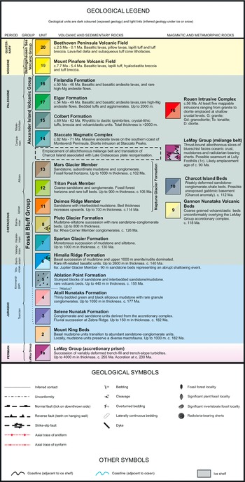
Figure 3. Geological legend from the new geological map of Alexander Island (Riley et al. Reference Riley, Curtis, Crame, Cantrill and Macdonald2025) defining the full chronostratigraphy. Maximum depositional ages are from Riley et al. (Reference Riley, Millar, Carter, Flowerdew, Burton-Johnson and Bastias2023, Reference Riley, Flowerdew, Carter, Curtis, Millar, Crame and Whitehouse2024).
Lithostratigraphy and chronostratigraphy
The geology of Alexander Island can be subdivided into four primary geological groups. The new geological map subdivides these four groups into 20 separate mappable units (Fig. 3). Many of these units have been formally defined (e.g. Tranter 1986, Butterworth et al. Reference Butterworth, Crame, Howlett and Macdonald1988, McCarron Reference McCarron1997, Smellie & Hole Reference Smellie, Hole, Smellie, Panter and Geyer2021); however, several more minor units are informally defined for the first time during the compilation of this map as a consequence of the analysis of legacy data and detrital zircon analysis (Riley et al. Reference Riley, Millar, Carter, Flowerdew, Burton-Johnson and Bastias2023, Reference Riley, Flowerdew, Carter, Curtis, Millar, Crame and Whitehouse2024).
The geological history of Alexander Island is central to tectonic models of the Antarctic Peninsula. Vaughan & Storey (Reference Vaughan and Storey2000) interpreted Alexander Island as a subduction-accretion complex to the central Antarctic Peninsula, or alternatively as an exotic terrane that ‘docked’ with the Antarctic Peninsula during a mid-Cretaceous tectonic episode known as the Palmer Land Event (Vaughan et al. Reference Vaughan, Eagles and Flowerdew2012). Further analysis has challenged a segmented model for the Antarctic Peninsula and an exotic origin for Alexander Island (Burton-Johnson & Riley Reference Burton-Johnson and Riley2015, Bastias et al. Reference Bastias-Silva, Burton-Johnson, Chew, Riley, Jara and Chiaradia2024), although Riley et al. (Reference Riley, Millar, Carter, Flowerdew, Burton-Johnson and Bastias2023) favoured some degree of translation to the west of Alexander Island involving Charcot Island (Fig. 2).
LeMay Group accretionary complex (units 1a, 1b and 1c)
The LeMay Group is a thick (~4 km) succession of trench-fill turbidites, trench-slope units and allochthonous slices of ocean floor, potentially including remnant ocean island material and chert sequences (Tranter 1986). The accretionary complex is variably deformed and incorporates mélange belts (Fig. 4). The trench-fill units are composed of medium-grained arkosic sandstone and massive greywacke, interbedded with black shale units. The trench-slope deposits are characterized by coarse conglomerate-sandstone units interbedded with thinly bedded turbidite.

Figure 4. Geological inset map of south-east Alexander Island. See Fig. 2 for location and Fig. 3 for the geological legend. The extent of the Neptune Glacier Formation is shown that forms the uppermost sequence of the Fossil Bluff Group. In addition, the linear extent of the basin-wide Himalia Ridge Formation that is in faulted contact with the basement LeMay Group accretionary prism is shown.
Tranter (Reference Tranter1987) examined the tectonic history of the LeMay Group and suggested a polyphase structural history that could be interpreted in terms of an accretion-subduction setting. The earliest deformational event is recognized across the entire LeMay Group as layer-parallel fabrics, disruption of strata and thrust tectonics in poorly lithified sediments. A separate deformational event is characterized by westward-directed thrusts and westward-verging folds that deform the earlier structures. This secondary phase of deformation has been related to strike-slip motion that developed in the arc prism in response to subduction-related stresses.
The complex nature of the LeMay Group has led to considerable uncertainty in determining the age of deposition and deformation. Previous studies (e.g. Thomson & Tranter Reference Tranter1988, Holdsworth & Nell Reference Holdsworth and Nell1992, Kelly et al. Reference Kelly, Doubleday, Brunton, Dickins, Sevastopulo and Taylor2001) have suggested ages that range from Carboniferous to Cretaceous, with much of this uncertainty being a result of how different units within the LeMay Group relate to each other.
A detailed U-Pb and Lu-Hf detrital zircon analysis of the entire LeMay Group (Riley et al. Reference Riley, Millar, Carter, Flowerdew, Burton-Johnson and Bastias2023) completely revised the depositional and deformational history. The main depositional phase of the LeMay Group (unit 1a; Fig. 3) is late Permian (c. 255 Ma) and can be correlated with a network of Permian accretionary complexes of the West Gondwana margin. Lithological units at Mount King and Charcot Island, previously included within the LeMay Group, are no longer considered part of the late Permian accretionary complex and will be discussed in units 2 and 10, respectively.
Although the depositional history of the accretionary prism (unit 1a) is well constrained to the late Permian (c. 255 Ma), the age of accretion is less certain. Accretionary complexes from South America and the northern Antarctic Peninsula have probable accretionary ages in the Late Triassic (c. 230 Ma; Trouw et al. 1997), which is also suggested for the LeMay Group based on white mica 40Ar/39Ar ages (Riley et al. Reference Riley, Millar, Carter, Flowerdew, Burton-Johnson and Bastias2023). The development of thrust-bound mélange belts (unit 1b; Fig. 3) and accretion of ocean floor material, including seamounts (unit 1c; Fig. 3), are considered to be mid-Cretaceous in age and associated with the accretion of the exotic Charcot Island block at c. 90 Ma (Riley et al. Reference Riley, Millar, Carter, Flowerdew, Burton-Johnson and Bastias2023), consistent with the mid-Cretaceous plate models of Larter et al. (Reference Larter, Cunningham, Barker, Gohl and Nitsche2002).
Mount King Beds (unit 2)
Sedimentary successions from the Mount King area, adjacent to King George VI Sound (Fig. 5), were described by Kelly et al. (Reference Kelly, Doubleday, Brunton, Dickins, Sevastopulo and Taylor2001), who investigated a diverse marine macrofauna in a sandstone-mudstone-conglomerate succession up to 1 km in thickness. The mudstone units are rich in marine macrofauna, and they were assigned a Palaeozoic age by Kelly et al. (Reference Kelly, Doubleday, Brunton, Dickins, Sevastopulo and Taylor2001), who acknowledged that the succession at Mount King was distinct from other lithologies on Alexander Island, and that they have undergone significant reworking. They considered the possibility that the Mount King Beds could represent the basement to the adjacent Fossil Bluff Group, but on balance they determined a lithostratigraphical relationship to the LeMay Group was more probable based on their interpretation of a Carboniferous macrofauna. Such an age was consistent with the lower Trinity Peninsula Group from northern Graham Land (Bradshaw et al. Reference Bradshaw, Vaughan, Millar, Flowerdew, Trouw, Fanning and Whitehouse2012), which also forms a Late Palaeozoic accretionary complex.

Figure 5. Geological inset map of central eastern Alexander Island. See Fig. 2 for location and Fig. 3 for the geological legend. The northernmost extent of the Fossil Bluff Group is shown, highlighting the basin-wide extent of the Himalia Ridge Formation and the linear belt of the Selene Nunatak Formation in faulted and unconformable contact with the LeMay Group. The volcanic successions of the Alexander Island Volcanic Group are evident at the Colbert Mountains, Walton Heights and Finlandia Foothills. At Lully Foothills, the Radiolarian cherts and seamount are exposed (unit 1c).
Detrital zircon analysis of the Mount King Beds (Riley et al. Reference Riley, Millar, Carter, Flowerdew, Burton-Johnson and Bastias2023) revealed a more complex history for the succession and demonstrated that the succession is distinct from the main LeMay Group accretionary prism of Alexander Island. The primary detrital zircon age populations from Mount King are Mesozoic, with a peak in the Middle Triassic (c. 225 Ma) and rare zircons from the Early Jurassic (c. 178 Ma), which was interpreted as the maximum probable depositional age. An Early Jurassic age is consistent with the adjacent Selene Nunatak Formation (unit 3) at Zebra Ridge, which also has a probable maximum depositional age from the Early Jurassic (Riley et al. Reference Riley, Flowerdew, Carter, Curtis, Millar, Crame and Whitehouse2024).
Although the detrital zircon data and potential overlap with the adjacent Selene Nunatak Formation strongly support an Early Jurassic depositional age for the Mount King Beds, this is in disagreement with the Carboniferous age proposed by Kelly et al. (Reference Kelly, Doubleday, Brunton, Dickins, Sevastopulo and Taylor2001) based on the marine macrofauna and Bryozoa. If the fauna ages are correct, then the Mount King Beds may form the basal unit of the LeMay Group accretionary complex but were reworked during the initial formation of the forearc basin as suggested by Kelly et al. (Reference Kelly, Doubleday, Brunton, Dickins, Sevastopulo and Taylor2001). We, too, favour a reworked origin for this isolated stratigraphic unit during the Early Jurassic, prior to trench-slope deposition of the Selene Nunatak Formation.
Selene Nunatak Formation (unit 3)
The Selene Nunatak Formation crops out in a discontinuous belt on the eastern side of the LeMay Range Fault (Fig. 4). The type section for the Selene Nunatak Formation is the northern face of Selene Nunatak (Fig. 4), where a ~115 m sequence unconformably overlies the LeMay Group, although the top part of the sequence is not observed. The Selene Nunatak Formation has previously been considered to form the basal section of the Fossil Bluff Group (Doubleday et al. Reference Doubleday, Macdonald and Nell1993), but analysis by Riley et al. (Reference Riley, Flowerdew, Carter, Curtis, Millar, Crame and Whitehouse2024), combined with the new geological map (Riley et al. Reference Riley, Curtis, Crame, Cantrill and Macdonald2025), has led to the removal of the Selene Nunatak and Atoll Nunataks formations from the Fossil Bluff Group given their transitional setting and significant hiatus before forearc development in the Late Jurassic. Other parts of the succession have been identified at the southern end of the Douglas Range and at Zebra Ridge (Figs 5 & 6), where the formation is up to 150 m in thickness, but neither the base nor top are exposed. The Selene Nunatak Formation is composed almost entirely of conglomerate and sandstone and is characterized by pebble-cobble conglomerate and detritus derived from the LeMay Group accretionary complex, with clasts of vein quartz, chert and metasedimentary rock.

Figure 6. Steeply dipping sedimentary rocks of the Selene Nunatak Formation exposed at Zebra Ridge. Tabular sandstone unit deposited in a braided river setting. Succession is ~50 m in height.
Rare molluscan fauna have been identified from several localities in the upper part of the Selene Nunatak Formation, including poorly preserved belemnite fragments at Selene Nunatak, and abundant bivalves from Nonplus Crag (Fig. 5), including current-orientated Tancredia, with less common Entolium near the base of the section.
Fossil plant remains are abundant in the Selene Nunatak Formation at Zebra Ridge (Fig. 5) and are dominated by Pteridophytes (ferns) and Coniferales. The cladophleboid ferns are the most striking elements of the flora, occurring as large fronds up to 1 m long scattered over bedding surfaces. The flora of fronds, leaves and rare fertile remains (cone scales) are all preserved as impressions. They almost exclusively lie on top of soil horizons, indicating an in situ flora, representative of a leaf litter layer. Carbonized casts of trees up to 1 m in diameter and over 3 m in length indicate the former presence of substantial forests. It is probable that the flora was composed of a coniferous overstorey with a predominantly fern understorey.
The Selene Nunatak Formation is interpreted to represent the erosion of an emergent part of the accretionary prism. The abundance of plant material and the paucity of marine fauna point to a terrestrial setting for most of the formation, with the most probable setting being an alluvial fan or lacustrine fan-delta. The presence of belemnites high in the succession at Selene Nunatak and of a shallow-water fauna at Nonplus Crag (Fig. 5), taken together with the fact that the mudstone units of the overlying Atoll Nunataks Formation are clearly marine, suggests that upper levels of the Selene Nunatak Formation represent a marine transgression.
Molluscan bivalves (Entolium) from the western end of Nonplus Crag compare closely to South American samples, which suggests correlation with the latest Pliensbachian to earliest Toarcian of Argentina (Damborenea 2002). In addition, further east along Nonplus Crag, molluscan fauna identified in the overlying Atoll Nunataks Formation (Fig. 5) includes poorly preserved Retroceramus of probable Middle Jurassic age, although these are not diagnostic in their own right.
An Early to Middle Jurassic age for the Selene Nunatak Formation is consistent with the detrital zircon analysis of Riley et al. (Reference Riley, Flowerdew, Carter, Curtis, Millar, Crame and Whitehouse2024), who also determined an Early Jurassic maximum depositional age. They identified that the zircon age population of the Selene Nunatak Formation was dominated by age peaks at c. 255 Ma, overlapping with the primary age profile of the LeMay Group accretionary complex of Riley et al. (Reference Riley, Millar, Carter, Flowerdew, Burton-Johnson and Bastias2023), which is consistent with a strong local bias and a proximal source-sink depositional environment.
Atoll Nunataks Formation (unit 4)
The Atoll Nunataks Formation forms a narrow belt trending north-south, to the east of the LeMay Range (Fig. 5). The succession is adjacent to and conformably overlying the Selene Nunatak Formation, and it forms a sequence ~1050 m in thickness. The type section has been described by Doubleday et al. (Reference Doubleday, Macdonald and Nell1993) as from the eastern Atoll Nunataks (Fig. 4), who inferred a probable trench-slope depositional environment, with units that dip beneath the forearc sequences to the east. Doubleday et al. (Reference Doubleday, Macdonald and Nell1993) recognized two members within the Atoll Nunataks Formation: the basal member sits conformably above the Selene Nunatak Formation and is recognized from the eastern Atoll Nunataks. The unit is at least 525 m in thickness and is dominated by green mudstone with subordinate black shaly mudstone and sandstone interbeds. The basal member is overlain by a succession of rhythmically interbedded mudstones (~500 m) with thin sandstone beds (Holdsworth & Nell Reference Holdsworth and Nell1992). This upper unit is interpreted as turbiditic and has a mixed shelly fauna of bivalves, belemnites and ammonites, alongside plant fragments. A Bathonian to Tithonian age has been constrained by Radiolaria from the base of the lower member at Atoll Nunataks (Holdsworth & Nell Reference Holdsworth and Nell1992).
Riley et al. (Reference Riley, Flowerdew, Carter, Curtis, Millar, Crame and Whitehouse2024) investigated the detrital zircon age profile of a sandstone bed from the central sector of the Atoll Nunataks Formation, west of Lunar Crag (Fig. 4). They reported a maximum depositional age of c. 177 Ma (Toarcian), significantly older than the Late Jurassic ages reported by Holdsworth & Nell (Reference Holdsworth and Nell1992) and Crame & Howlett (Reference Crame and Howlett1988) using palaeontological controls, although the molluscan fauna are not considered particularly age diagnostic and there was uncertainty as to whether the Radiolaria examined by Holdsworth & Nell (Reference Holdsworth and Nell1992) were from the Atoll Nunataks Formation. An Early Jurassic age for the Atoll Nunataks Formation is consistent with an Early Jurassic age for the underlying Selene Nunatak Formation, but with the caveat that the detrital zircon ages only provide a maximum depositional constraint. Detrital zircon analysis (Riley et al. Reference Riley, Flowerdew, Carter, Curtis, Millar, Crame and Whitehouse2024) also demonstrated that there was no evidence for any contribution from the adjacent LeMay Group or underlying Selene Nunatak Formation into the Atoll Nunataks Formation, which has no Palaeozoic signal in the age profile. This observation is not in agreement with the interpretation of Doubleday et al. (Reference Doubleday, Macdonald and Nell1993), who suggested the Atoll Nunataks Formation was derived from the proximal LeMay Group accretionary prism. A conformable relationship between the basal Atoll Nunataks Formation and the Selene Nunatak Formation (Doubleday et al. Reference Doubleday, Macdonald and Nell1993) requires an abrupt shift in depositional environment from non-marine alluvial fans to trench-slope, which is suggested by the presence of marine belemnites from the upper Selene Nunatak Formation. This transition also led to a significant change in sediment source, given the complete absence of any recycled material from the late Permian LeMay Group in the Atoll Nunataks Formation succession, which is abundant in the Selene Nunatak Formation (Riley et al. Reference Riley, Flowerdew, Carter, Curtis, Millar, Crame and Whitehouse2024).
The Atoll Nunataks Formation has no penetrative fabric but is characterized by minor normal and thrust faults at Atoll Nunataks.
Fossil Bluff Group (units 5–8 and 11–13)
The Fossil Bluff Group of Alexander Island preserves over 8 km of arc-derived material deposited into a forearc basin that developed unconformably above the LeMay Group and Atoll Nunataks Formation. The Fossil Bluff Group is exposed along the eastern margin of Alexander Island and forms a narrow belt of ~250 km in length. It has a depositional history from the Late Jurassic to the mid-Cretaceous and forms one of the most complete ancient forearc successions in the world from basin development to basin shallowing and cessation of associated volcanism (Doubleday et al. Reference Doubleday, Macdonald and Nell1993).
The base of the Fossil Bluff Group has been considered to be defined by the Selene Nunatak Formation (Doubleday et al. Reference Doubleday, Macdonald and Nell1993), which lies unconformably above the LeMay Group accretionary complex, but Riley et al. (Reference Riley, Flowerdew, Carter, Curtis, Millar, Crame and Whitehouse2024) determined a hiatus of zircon ages of at least 20 Myr (Fig. 3) between deposition of the Atoll Nunataks Formation (c. 177 Ma) and onset of sedimentation in the Ablation Point Formation (c. 155 Ma), but with the understanding that these are maximum depositional ages. This potential hiatus, combined with the continuous sedimentation that followed the deposition of the Ablation Point Formation, led Riley et al. (Reference Riley, Flowerdew, Carter, Curtis, Millar, Crame and Whitehouse2024) to suggest that the base of the Fossil Bluff Group forearc succession was defined by the Ablation Point Formation, with the Atoll Nunataks and Selene Nunatak formations representing initially a non-marine alluvial fan setting before an abrupt transition to a trench-slope environment (Middle Jurassic), prior to transition to a forearc environment in the Late Jurassic. This may in future necessitate a revised grouping for the Atoll Nunataks and Selene Nunataks formations, as well as consideration of the Mount King Beds (Fig. 3).
Ablation Point Formation (unit 5)
The Ablation Point Formation is restricted to the eastern margin of Alexander Island (Fig. 5) and the western coast of north-west Palmer Land at Carse Point (Fig. 2). It comprises a sequence of highly contorted and brecciated strata, with slumped blocks of sandstone and sandstone/mudstone interbeds, and it may represent a fold and thrust belt. The entire sequence is estimated to be 440 m in thickness at Himalia Ridge (Fig. 5), although the base of the section is not exposed. Butterworth et al. (Reference Butterworth, Crame, Howlett and Macdonald1988) defined two type sections from the Ablation Point Formation, at Belemnite Point and at the central part of Himalia Ridge (Fig. 5). At Himalia Ridge there are a wide range of chaotic slump-folded and rafted blocks (tens of metres) of sedimentary and volcanic lithologies (basaltic and rhyolitic), including ignimbrite, lava, tuffs and volcaniclastic sandstones. The slump blocks are associated with mélange beds which host < 1 m sandstone blocks in a sheared mudstone matrix. At Belemnite Point (Fig. 5), the basal zone is host to large, rotated blocks overlain by mudstone beds. The Ablation Point Formation represents a slope collapse deposit that marks the transition from trench-slope to forearc deposition.
Crame & Howlett (Reference Crame and Howlett1988) suggested a Kimmeridgian age for the Ablation Point Formation based on the sparse and poorly preserved molluscan fauna. This age was confirmed by Riley et al. (Reference Riley, Flowerdew, Carter, Curtis, Millar, Crame and Whitehouse2024) using detrital zircon analysis that suggests a maximum depositional age of c. 155 Ma.
Himalia Ridge Formation (unit 6)
The Himalia Ridge Formation has a maximum thickness of ~2600 m exposed at Himalia Ridge and is the only unit of the Fossil Bluff Group that has a basin-wide extent. The Himalia Ridge Formation is a highly variable stratigraphic unit characterized by multiple facies with considerable lateral variation. Four major channelled conglomerate complexes have been recognized throughout the succession that form prominent, steep scarps. The conglomerate complexes are 80–170 m in thickness and are formed of scoured, clast-supported, graded conglomerate beds overlain by sandstone beds with palaeoflow indicators suggesting derivation from the magmatic arc to the east. Slump sheets, slump folds and syn-sedimentary normal faults are common throughout the succession. The type section at Himalia Ridge (Fig. 5) includes a basal mudstone unit up to 1100 m in thickness overlain by mudstone-sandstone interbeds ~1000 m in thickness. The base of the Himalia Ridge Formation is highly variable and rests unconformably upon the Ablation Point Formation at Himalia Ridge, but in many places it lies directly above the basement LeMay Group accretionary complex (Butterworth et al. Reference Butterworth, Crame, Howlett and Macdonald1988).
The formation was deposited as a series of migrating inner-fan channels leading to conglomerate and mudstone-sandstone facies (Fig. 7). The conglomerate beds have been used to interpret tectonic cycles in the adjacent arc (Butterworth Reference Butterworth and Macdonald1991). A transition in conglomerate clast composition from volcanic to plutonic through the Himalia Ridge Formation indicates significant arc uplift attributed to arc unroofing. This interpretation is also supported by sandstone petrofacies analysis (Butterworth Reference Butterworth and Macdonald1991).

Figure 7. Upper section of the Himalia Ridge Formation at Ablation Valley. Succession is ~100 m in height.
The age of the Himalia Ridge Formation is well constrained by an abundant and diverse molluscan fauna (Butterworth et al. Reference Butterworth, Crame, Howlett and Macdonald1988). At the type section at Himalia Ridge, the lowermost ~1000 m has a fauna indicating a Tithonian age (Fig. 8; Thomson Reference Thomson1979, Crame & Howlett Reference Crame and Howlett1988). The upper ~1000 m of the succession is absent of fossils, with the exception of the uppermost ~50 m, which is host to ammonites that are Berriasian (Crame Reference Crame1985, Crame & Howlett Reference Crame and Howlett1988). Detrital zircon analysis (Riley et al. Reference Riley, Flowerdew, Carter, Curtis, Millar, Crame and Whitehouse2024) from several sites across the Himalia Ridge Formation suggests a maximum depositional age of c. 140 Ma, which is in agreement with the fossil fauna assemblage (c. 143–137 Ma).

Figure 8. Upper Tithonian ammonite, Virgatosphinctes, from the Himalia Ridge Formation at Ablation Valley. Specimen is 11 cm in diameter.
The uppermost part of the succession is defined as the Jupiter Glacier Member (70–90 m thickness; Fig. 3) and represents an abrupt transition to a sequence of fine-grained laminated sandstone beds as a result of a regional shallowing event (Butterworth Reference Butterworth and Macdonald1991). The Jupiter Glacier Member is best exposed at Callisto Cliffs on the southern margin of the Jupiter Glacier (Fig. 5). The Jupiter Glacier Member is host to a well-preserved, diverse molluscan fauna of possible Valanginian age (Butterworth Reference Butterworth and Macdonald1991).
Macdonald et al. (Reference Macdonald, Leat, Doubleday and Kelly1999) reported basaltic and rhyolitic sills and lava flows that were emplaced coeval with sedimentation. The basaltic rocks have ocean island basalt-like chemistry and are interpreted to have been generated by partial melting of asthenospheric mantle during rifting.
Spartan Glacier Formation (unit 7)
The Spartan Glacier Formation has a thickness of ~1 km and crops out extensively across the central part of the Fossil Bluff Group succession between Grotto Glacier and Uranus Glacier (Figs 4 & 5). The base of the Spartan Glacier Formation is marked by the cessation of coarse-grained sedimentation of the Himalia Ridge Formation and the onset of mudstone-dominated sedimentation (Fig. 9) in a tectonically quiescent setting following basement uplift in the continental arc.

Figure 9. a. Upper boundary of the Spartan Glacier Formation with the overlying Pluto Glacier Formation viewed from Fossil Bluff. The boundary is well exposed on the summit cone of Khufu Peak (’Pyramid’, skyline, right of centre). b. Upper boundary of the Spartan Glacier Formation with the overlying Pluto Glacier Formation on Giza Peak (’Sphinx’).
Butterworth et al. (Reference Butterworth, Crame, Howlett and Macdonald1988) and Butterworth (Reference Butterworth and Macdonald1991) described the Spartan Glacier Formation as a monotonous sequence of mudstone and siltstone with minor thin, fine-grained sandstone interbeds. The succession is characterized by syn-sedimentary mélanges up to 120 m in thickness and associated slump units.
The sandstone beds are typically graded and/or parallel- or ripple-cross-laminated. They vary in thickness from 2 to 20 m and are laterally discontinuous. A distinctive, strongly bioturbated sandstone unit 160 m in thickness crops out at Spartan Glacier near the upper part of the succession and forms a pronounced stepped scarp topography.
The Spartan Glacier Formation is host to a diverse molluscan fauna but is not considered particularly age diagnostic, although an Early Cretaceous (Berriasian–Hauterivian) age has been suggested by Crame & Howlett (Reference Crame and Howlett1988). The molluscan fauna can be divided into three distinct groupings, with the lowest (~580 m) part of the succession dominated by belemnopseid belemnites, which are associated with ammonites of probable Valanginian age (Crame & Howlett Reference Crame and Howlett1988). The second group (580–950 m stratigraphic height) is dominated by bivalves, which begin after the last occurrence of belemnopseid belemnites. The bivalves are diverse but not age diagnostic, and a tentative late Hauterivian–Barremian age was proposed by Crame & Howlett (Reference Crame and Howlett1988). The uppermost unit, from above 950 m, is host to abundant aconceratid ammonites, along with bivalves, and it has been suggested to be Aptian in age (Crame & Howlett Reference Crame and Howlett1988), although Thomson (Reference Thomson1974) preferred an older age (Barremian).
An Early Cretaceous age is supported by the detrital zircon analysis of Riley et al. (Reference Riley, Flowerdew, Carter, Curtis, Millar, Crame and Whitehouse2024), who determined maximum depositional ages of c. 130 Ma (Hauterivian) from two sites across the Spartan Glacier Formation.
From Waitabit Cliffs to Triton Point (Fig. 4), several lamprophyric (camptonite) dykes have been identified that intrude the Spartan Glacier, Pluto Glacier and Neptune Glacier formations (Horne & Thomson Reference Horne and Thomson1967). The dykes are typically 1–3 m in width. They are highly potassic and were considered to be late Cenozoic in age.
Pluto Glacier Formation (unit 8)
The Pluto Glacier Formation has a thickness of up to 800 m (Moncrieff & Kelly Reference Moncrieff and Kelly1993) that extends from south-eastern Alexander Island to the Uranus Glacier, with a faulted section also identified at Succession Cliffs (Figs 4 & 10) and isolated outcrops at Fossil Bluff and Mount Ariel (Fig. 4). The upper part of the sequence is exposed at the western end of Offset Ridge (Fig. 4), where it is unconformably overlain by the base of the Neptune Glacier Formation (Deimos Ridge Member). The boundary is marked by prominent coarse sandstone beds, which are also exposed at Keystone Cliffs (Fig. 4). The lowermost 300 m of the Pluto Glacier Formation is exposed in a reverse faulted block that is located between Succession Cliffs (Fig. 10) and Callisto Cliffs (Fig. 4). This lower sequence is punctuated by two prominent sandstone beds up to 15 m in thickness, with the sandstone at the base informally referred to as the Callisto Cliffs Member. An upper sandstone-conglomerate sequence is recognized from Rhea Corner (Fig. 4) and has been formally defined (Moncrieff & Kelly Reference Moncrieff and Kelly1993) as the Rhea Corner Member (unit 8a; Fig. 3), which has a thickness of ~370 m and a strongly erosive base. The main succession of the Pluto Glacier Formation (Crame & Francis Reference Crame and Francis2025) is dominated by siltstone/mudstone and occasional sandstone interbeds. The siltstone units are typically black and often weather into distinctive pillars. The sandstone beds are intensely bioturbated, although rare cross-stratification is evident where bioturbation is less intense.

Figure 10. Sequence of mudstones and siltstones (~310 m height) of the Pluto Glacier Formation (Fossil Bluff Group) at Succession Cliffs, eastern Alexander Island.
The age of the Pluto Glacier Formation is well constrained by its abundant molluscan fauna (Thomson Reference Thomson1974, Doyle Reference Doyle1987, Crame & Howlett Reference Crame and Howlett1988). The broad consensus is that the formation lies within the Aptian stage, with Crame & Howlett (Reference Crame and Howlett1988) identifying an Aptian age for the base of the formation based on the identification of aconceratid and large heteromorph ammonites. Moncrieff & Kelly (Reference Moncrieff and Kelly1993) determined that the top of the Pluto Glacier Formation is Albian in age, with no evidence of any Aptian fauna in the Rhea Corner Member. A mid-Cretaceous age for the Pluto Glacier Formation is supported by the detrital zircon analysis of Riley et al. (Reference Riley, Flowerdew, Carter, Curtis, Millar, Crame and Whitehouse2024), who analysed three samples from the Pluto Glacier Formation that all exhibited very similar age distributions, having prominent Early to mid-Cretaceous age peaks at c. 126 Ma that constitute ~90% of the detrital zircon age population. This provides a maximum depositional age in the range 129–124 Ma, and the profiles suggests a very strong local bias, with very little input from recycled basement. The detrital zircon depositional ages are slightly older than the ages suggested by the molluscan fauna (c. 120 Ma) but do only provide a maximum age constraint.
The depositional environment for the Pluto Glacier Formation is likely to have been an open basin to shelf setting, with evidence of protected marine conditions suggested by the presence of spatangoid echinoids (Moncrieff & Kelly Reference Moncrieff and Kelly1993).
Neptune Glacier Formation (units 11–13)
The uppermost sequence of the Fossil Bluff Group is the mid-Cretaceous Neptune Glacier Formation that forms a succession 2600 m in thickness (Fig. 3) exposed extensively across the south-eastern sector of Alexander Island (Fig. 4). The Neptune Glacier Formation has been separated into three separate units (Deimos Ridge, Triton Point and Mars Glacier members; Fig. 3), which will be examined separately here.
Deimos Ridge Member (unit 11)
The Deimos Ridge Member crops out in south-east Alexander Island in a narrow band from Venus Glacier in the north to Tethys Nunatak in the south (Fig. 4). The ~700 m succession conformably overlies the Pluto Glacier Formation and is dominated by sandstone with mudstone interbeds. The Deimos Ridge Member has been correlated with the Milestone Bluff Formation of central Adelaide Island to the north (Fig. 1), which forms an extension of the forearc succession (Riley et al. Reference Riley, Flowerdew and Whitehouse2012).
The type section for the Deimos Ridge Member is from the western point of Rhea Corner, adjacent to Deimos Ridge (Fig. 4), and is defined at the point where the dominantly mudstone succession of the Pluto Glacier Formation transitions to normally graded sandstones. The top of the Deimos Ridge Member is defined at the first appearance of in situ terrestrial vegetation (Moncrieff & Kelly Reference Moncrieff and Kelly1993). The Deimos Ridge Member is dominated by coarse-grained sandstone units interbedded with mudstone. The sandstone beds are tabular units with poorly defined parallel lamination and normal grading, with widespread bioturbation.
The age of the Deimos Ridge Member is considered to be late Albian (Moncrieff & Kelly Reference Moncrieff and Kelly1993) based on a scattered molluscan fauna. Detrital zircon analysis by Riley et al. (Reference Riley, Flowerdew, Carter, Curtis, Millar, Crame and Whitehouse2024) was not carried out directly on the Deimos Ridge Member, but a single sample from the correlative Milestone Bluff Formation of Adelaide Island yielded a maximum depositional age of c. 112 Ma, which is consistent with the Albian fauna.
The depositional environment for the Deimos Ridge Member is likely to be an open basin, but with a shallow/tidal environment evident from the upper part of the succession where complex, cross-bedded units are evident. Muddy sandstone beds and sub-horizontal trace fossils suggest stable offshore bars in the upper part of the Deimos Ridge Member, but with a return to a higher-energy environment at the very tip of the succession (Moncrieff & Kelly Reference Moncrieff and Kelly1993).
Triton Point Member (unit 12)
The Triton Point Member has a broad areal extent across south-east Alexander Island, extending from Tethys Nunataks to the coast (Fig. 4). The unit has a thickness of ~900 m, with the main succession best exposed in the south (Nichols & Cantrill Reference Nichols and Cantrill2002), where standing trees are preserved. The basal part of the succession is exposed at Triton Point, where a ~75 m sequence has been identified (Nichols & Cantrill Reference Nichols and Cantrill2002), with the base defined by the appearance of in situ terrestrial vegetation (Moncrieff & Kelly Reference Moncrieff and Kelly1993).
The Triton Point Member thickens considerably to the south, reaching a thickness of ~900 m at Coal Nunataks, Titan Nunatak and Corner Cliffs (Figs 4 & 11). Nichols & Cantrill (Reference Nichols and Cantrill2002) raised the Triton Point Member to formation status, as it can be defined by a distinct and correlatable basal unit. They also defined three mappable units: the basal Citadel Bastion Member, the Coal Nunatak Member and the Upper Coal Nunatak Sandstone Bed. However, the new geological map does not follow the updated stratigraphy for the Triton Point Member, as an updated lithostratigraphy is also required for the entire Neptune Glacier Formation, which has not yet been defined. However, we do use the facies descriptions of Nichols & Cantrill (Reference Nichols and Cantrill2002). The main succession (~700 m) defined by Nichols & Cantrill (Reference Nichols and Cantrill2002) as the Citadel Bastion Member is exposed at Citadel Bastion, Titan Nunatak and the lower part of Coal Nunatak (Fig. 4). The sequence is dominated by coarse, channel-fill sandstone deposited in a braided river environment (Fig. 11), associated with finer-grained overbank facies with abundant plant material (Fig. 12; Falcon-Lang et al. Reference Falcon-Lang, Cantrill and Nichols2001, Nagalingum & Cantrill Reference Nagalingum and Cantrill2006).

Figure 11. Lower braided unit with continuous sandstone cliffs and upper unit with discontinuous sandstone channels of the Triton Point Member (Neptune Glacier Formation) at Coal Nunatak. Cliff height is ~250 m. Titan Nunatak visible in the background.

Figure 12. Fossil fern (Gleicheniaceaephyllum acutum) from the Triton Point Member at Titan Nunatak (Nagalingum & Cantrill Reference Nagalingum and Cantrill2006).
The upper part of the succession, defined by Nichols & Cantrill (Reference Nichols and Cantrill2002) as the Coal Nunatak Member, is ~135 m in thickness and has a higher proportion of mudstones relative to the Citadel Bastion Member, and it was deposited in a meandering river setting (Falcon-Lang et al. Reference Falcon-Lang, Cantrill and Nichols2001). Volcanic ash horizons up to 2 m thick occur within this part of the succession where they truncate fossil forest horizons. The top of the Triton Point Member succession is defined by a cross-bedded sandstone bed that has been interpreted as a return to marine conditions.
Jefferson (Reference Jefferson1982) suggested an Aptian–Albian age based on the fossil forests and associated flora from the Triton Point Member, whilst Crame & Howlett (Reference Crame and Howlett1988) suggested a late Albian age based on a marine fauna from the upper sandstone bed. More recent palaeobotanical studies (e.g. Cantrill Reference Cantrill1996, Reference Cantrill1997, Cantrill & Nichols Reference Cantrill and Nichols1996) supported the Albian age proposed by Crame & Howlett (Reference Crame and Howlett1988). Riley et al. (Reference Riley, Flowerdew, Carter, Curtis, Millar, Crame and Whitehouse2024) examined the detrital zircon age profile of a sandstone unit from the Triton Point Member at Coal Nunatak and suggested a maximum depositional age of c. 105 Ma based on a prominent age peak. This age is in agreement with a late Albian depositional age from the upper part of the sequence.
Mars Glacier Member (unit 13)
The uppermost unit of the entire Fossil Bluff Group succession is the Mars Glacier Member (Fig. 3), which crops out from Triton Point to Two Step Cliffs (Fig. 4) and forms a succession almost ~1000 m in thickness. The type locality is defined at Triton Point and is marked by the appearance of marine fossils following the non-marine interval marked by the Triton Point Member. Although the Mars Glacier Member is defined at Triton Point, the main reference section is at Two Step Cliffs (Moncrieff & Kelly Reference Moncrieff and Kelly1993), where the succession is > 800 m in thickness. The Mars Glacier Member is dominated by tabular, normally graded sandstone beds up to 5 m in thickness, interbedded with thin mudstone horizons, which are characterized by an abundant marine fauna. Moncrieff & Kelly (Reference Moncrieff and Kelly1993) summarized the marine fauna and interpreted a broadly late Albian age for the Mars Glacier Member.
The Mars Glacier Member is interpreted as a transgressive sequence of nearshore tidal through to open basin, turbidite-dominated conditions, akin to the Deimos Ridge Member at the base of the Neptune Glacier Formation. The cessation of sedimentation in the late Albian marks the end of deposition into the forearc basin and corresponds with the waning of mid-Cretaceous magmatism in the continental arc (Riley et al. Reference Riley, Burton-Johnson, Flowerdew and Whitehouse2018) and the Palmer Land tectonic event (Vaughan et al. Reference Vaughan, Eagles and Flowerdew2012).
Gannon Nunataks Beds (unit 9)
The volcanic beds at Gannon Nunataks are poorly defined, and their full areal extent is not known. Gannon Nunataks is in central Alexander Island to the north-east of Lully Foothills (Fig. 5) and lies within the main outcrop area of the extensive LeMay Group accretionary complex (unit 1). The volcanic beds at Gannon Nunataks are coarse-grained volcaniclastic beds that unconformably overlie the LeMay Group accretionary prism metasedimentary succession. Riley et al. (Reference Riley, Millar, Carter, Flowerdew, Burton-Johnson and Bastias2023) investigated the detrital zircon ages of the volcaniclastic beds and identified a strongly unimodal age profile, with a prominent peak at c. 118 Ma, indicating derivation from a relatively proximal mid-Cretaceous volcanic source. The unit is broadly correlated with the base of the Aptian–Albian Neptune Glacier Formation (Deimos Ridge Member) and may be akin to the volcaniclastic and silicic tuff beds identified from Millstone Bluff Formation observed on Adelaide Island (Riley et al. Reference Riley, Flowerdew and Whitehouse2012).
Charcot Island Beds (unit 10)
Charcot Island lies to the west of Alexander Island and, although largely snow- and ice-covered, there are outcrops at Marion Nunataks along the north-west coast of the island (Fig. 2). The geology of north-west Charcot Island is primarily a sandstone-conglomerate-shale turbidite succession up to 100 m in thickness, and it was originally included within the LeMay Group accretionary complex (Tranter Reference Tranter1988). However, detrital zircon analysis by Riley et al. (Reference Riley, Millar, Carter, Flowerdew, Burton-Johnson and Bastias2023) on four samples from north-west Charcot Island demonstrated a mid-Cretaceous maximum depositional age (c. 112 Ma), with a primary contribution from an Early Jurassic source and a mixed Cambrian–Proterozoic recycled signature. However, there is no late Permian signal in the units from Charcot Island, indicating no contribution from the LeMay Group accretionary complex or contemporaneous deposition. Riley et al. (Reference Riley, Millar, Carter, Flowerdew, Burton-Johnson and Bastias2023) favoured a para-autochthonous origin for Charcot Island, and it is likely to represent a translated crustal block with accretion developing after 90 Ma associated with the mélange belts of central Alexander Island. Fission track data (Storey et al. Reference Storey, Brown, Carter, Doubleday, Hurford, Macdonald and Nell1996) indicate a shared tectonic history between Charcot Island and Alexander Island at c. 50 Ma, indicating that accretion occurred before this date.
Charcot Island is the site of the geophysically defined Charcot Anomaly (Johnson & Ferris Reference Johnson and Ferris1997) to the west of the Antarctic Peninsula, which is > 1000 km in length and has an uncertain origin. Vaughan et al. (Reference Vaughan, Eagles, Ferraccioli, Leat, Jordan and Coffin2013) considered the Charcot Anomaly to be Cretaceous in age, and it may represent a fragment of the Ontong-Java ocean plateau. The Charcot Island anomaly is likely to be defined by gabbroic intrusions, akin to the adjacent late Mesozoic–Cenozoic Pacific Margin Anomaly of the Antarctic Peninsula (Vaughan et al. Reference Vaughan, Wareham, Johnson and Kelley1998).
Alexander Island Volcanic Group (units 14–18)
The AIVG was defined by McCarron (Reference McCarron1997) as a succession of subduction-related magmatic rocks, and it excludes any accreted volcanic units present within the LeMay Group (units 1b and 1c), as well as any younger, post-subduction alkaline rocks (Bellingshausen Sea Volcanic Group; units 19 and 20). The AIVG is dominated by rhyolitic and dacitic ignimbrites, basaltic andesite to dacite lavas and redeposited fluvial and lacustrine volcaniclastic units. The group is exposed in a north-south belt along the length of Alexander Island, with the main areas of outcrop occurring in the Elgar Uplands, Finlandia Foothills, Colbert Mountains, Walton Mountains, Staccato Peaks and Monteverdi Peninsula (Fig. 2).
Staccato Magmatic Complex (unit 14)
The Staccato Magmatic Complex forms the lowermost unit of the AIVG (Fig. 3; McCarron Reference McCarron1997), which was defined as Late Cretaceous–Palaeogene subduction-related magmatic rocks of Alexander Island, including volcanic and plutonic lithologies. The Staccato Magmatic Complex is composed of three separate units: the Monteverdi Formation, the Staccato Formation and the Walton Formation, which crop out at isolated nunataks in the southern sector of Alexander Island. However, the new geological map uses the collective term ‘Staccato Magmatic Complex’ at 1:500 000 scale.
The Monteverdi Formation crops out along the southern coast of the Monteverdi Peninsula at the southern extremity of Alexander Island (Fig. 2). The exposures on the Monteverdi Peninsula are restricted to a small outcrop area and form a sequence of massive bedded basaltic andesite lavas up to 30 m in thickness, associated with altered volcaniclastic beds. The upper and lower parts of the succession are not observed, as the unit is restricted to a small area of ice-free cliffs (Fig. 13).

Figure 13. Massive bedded basaltic andesite lavas of the Monteverdi Formation (Staccato Magmatic Complex). The outcrop is up to 30 m in thickness and is exposed on the southern margin of the Monteverdi Peninsula. Image from Joe McCarron.
The basaltic-andesite lavas on the Monteverdi Peninsula have been dated at 79.7 ± 2.5 Ma (K/Ar hornblende; McCarron & Millar Reference McCarron and Millar1997) and represent the oldest exposed sequence of the AIVG.
The Staccato Formation is only recognized from Crotchet Nunatak, north-east of Staccato Peaks (Fig. 2), where tuffs and breccias of uncertain thickness crop out. McCarron (Reference McCarron1997) acknowledged that the volcanic rocks at Crotchet Nunatak were similar to the volcanic succession of the Walton Mountains, but that they defined a new formation name as the sequence at Crotchet Nunatak consists of a proximal volcanic facies comprising thick tuff beds and a coarse volcaniclastic breccia, as well as abundant juvenile detritus. It was determined that their distribution was very localized and could not be correlated with the units of the Walton Mountains, 40 km to the north (Fig. 2). The volcanic rocks of the Staccato Formation have not been dated directly, but an adjacent diorite pluton, which may be coeval, has yielded a zircon fission track age of 75 ± 4 Ma (Storey et al. Reference Storey, Brown, Carter, Doubleday, Hurford, Macdonald and Nell1996).
The Walton Formation is restricted to the Richter Peaks and Sevier Nunataks region at the southern margin of the Walton Mountains (Fig. 2) and was defined by McCarron (Reference McCarron1997). The volcanic rocks of the Walton Formation are represented by a sequence of volcaniclastic conglomerate units interbedded with basaltic-intermediate lava flows (Edwards Reference Edwards1980). The sequence of volcaniclastic beds and lava flows continues for ~250 m at Sevier Nunataks, with similar lithologies also described from the neighbouring Richter Peaks (McCarron Reference McCarron1997). There is no direct age constraint from the Walton Formation, but they are grouped together with the Late Cretaceous Staccato Magmatic Complex.
Colbert Formation (unit 15)
The Colbert Formation is an extensive volcanic succession that has an outcrop extent across the entire Colbert Mountains (Fig. 5). The succession has been described and defined by Burn (Reference Burn1981) and McCarron (Reference McCarron1997). Although the base of the sequence is not observed, it is inferred to unconformably overlie the LeMay Group accretionary complex. Overall, the succession is dominated by rhyolitic to dacitic ignimbrites, and there are also minor basaltic andesite lavas associated with volcaniclastic units. The entire succession is estimated to be > 2000 m in thickness (Fig. 3) and has been subdivided into nine separate members (C1–C9) interpreted as clearly defined eruptive cycles (McCarron Reference McCarron1997). The succession has been dated from several units and yield 40Ar/39Ar ages in the range 61.7 ± 0.8 to 64.5 ± 1.8 Ma (McCarron Reference McCarron1997).
The dominant unit across the Colbert Mountains is the C1 member of McCarron (Reference McCarron1997), which forms a succession up to 1400 m in thickness and comprises dacitic tuffs and ignimbrites, interbedded with lacustrine tuffs and intermediate lava units. The dacite lavas are typically up to 16 m in thickness and are locally columnar jointed. Members C2–C5 are dominated by dacitic-rhyolitic crystal-lithic tuffs and ignimbrites that often display well-developed columnar jointing (Fig. 14). Members C6–C8 are characterized by basaltic andesite/dacite lavas, breccias and volcaniclastic beds that have a total thickness approaching 500 m. The uppermost unit of the Colbert Formation (C9 member) is ~500 m in thickness and consists of a moderately dipping, massive, strongly welded crystal-rich silicic lava-like ignimbrite that is restricted to the south-east sector of the Colbert Mountains (McCarron & Millar Reference McCarron and Millar1997).

Figure 14. Columnar jointed rhyolitic ignimbrite unit from the C2 member of the Colbert Formation in the north-east Colbert Mountains. Image from Joe McCarron.
Overall, McCarron & Millar (Reference McCarron and Millar1997) interpreted the Colbert Mountains massif as representing a down-faulted caldera or a series of overlapping caldera edifices, with several members representing caldera-fill facies.
Rouen Intrusive Complex (unit 16)
Synchronous and interpreted to be co-magmatic with units of the AIVG are the intrusive rocks of the Rouen Intrusive Complex (McCarron Reference McCarron1997). Plutonic rocks of the Rouen Mountains, Rothschild Island and isolated nunataks across Alexander Island (Figs 2 & 15) have been investigated by Bell (Reference Bell1974), Care (Reference Care1980, Reference Care1983) and Kamenov & Pimpirev (1992). The granitoid compositions across the Rouen Intrusive Complex are varied, with five mappable intrusions identified and with compositions ranging from diorite to granite, as well as compositions of granite and granodiorite documented on Rothschild Island (Care Reference Care1980).

Figure 15. Geological inset map of northern Alexander Island. See Fig. 2 for location and Fig. 3 for the geological legend. The map highlights the extent of the Rouen Intrusive Complex and the andesitic lavas of the Elgar Formation that intrude and overlie, respectively, the LeMay Group accretionary complex. The uppermost basaltic lavas and breccias of the Mount Pinafore Volcanic Field are evident to the west of the Elgar Uplands.
The age of the Rouen Intrusive Complex is c. 56 Ma based on discordant U-Pb data (McCarron & Millar Reference McCarron and Millar1997) and zircon fission track data (Storey et al. Reference Storey, Brown, Carter, Doubleday, Hurford, Macdonald and Nell1996), although Rb-Sr dating (Pankhurst Reference Pankhurst1982, McCarron & Millar Reference McCarron and Millar1997) yield younger ages (47 ± 3 Ma). The ages are consistent with intrusive rocks from elsewhere to the west of the Antarctic Peninsula, with granitoids from Adelaide Island yielding ages in the range 52–47 Ma (Griffiths & Oglethorpe Reference Griffiths and Oglethorpe1998, Riley et al. Reference Riley, Flowerdew and Whitehouse2012), whilst quartz diorite from Dismal Island, lying in-between Adelaide and Alexander islands, has been dated at 48 ± 1 Ma (Karaoğlan et al. Reference Karaoğlan, KarataŞ, Özdemir, Gülyüz, Vassilev, Selbesoğlu and Gildir2023).
Elgar Formation (unit 17)
The Elgar Formation was first described and defined by Burn (Reference Burn1981) and incorporated the volcanic sequences exposed across the Elgar Uplands, Finlandia Foothills (Fig. 15) and Walton Heights (Fig. 5). However, McCarron (Reference McCarron1997) refined the Elgar Formation to only include sequences from the Elgar Uplands and separated the units at the Finlandia Foothills and Walton Heights into the overlying Finlandia Formation (unit 18).
The Elgar Formation consists of basaltic andesite to andesite lavas and volcanic breccias, associated with volcaniclastic layers, and it forms a succession up to 2000 m in thickness. The Elgar Formation unconformably overlies the metasedimentary basement of the LeMay Group accretionary complex and is in turn overlain locally by Neogene volcanic rocks of the Bellingshausen Sea Volcanic Group at Mount Pinafore (Fig. 15). McCarron (Reference McCarron1997) separated the Elgar Formation into three distinct units (members E1–E3) based on lithology and emplacement mechanism. The lowermost unit (E1) crops out in the south-east Elgar Uplands and consists of multiple andesite lava flow units, including rare high-Mg andesites associated with ridge subduction (McCarron & Smellie Reference McCarron and Smellie1998). In several areas, the volcanic sequences of the E1 member unconformably overlie the LeMay Group. The E1 member has been dated by McCarron (Reference McCarron1997) and yields an 40Ar/39Ar age of 53.3 ± 0.8 Ma.
The E2 member is lithologically similar to E1 and is composed of crystal-rich tuffs, lava flows and autoclastic lava breccias forming a succession up to 1000 m in thickness, which has been dated at 52.6 ± 1.6 Ma (McCarron Reference McCarron1997). The E3 member is confined to two isolated nunataks in the western Elgar Uplands and is composed of at least seven basaltic andesite/andesite lava flows interbedded with autoclastic lava breccias and rare volcaniclastic beds. The succession has a thickness of ~150 m and unconformably overlies the basement LeMay Group, with the succession younger than a dyke emplaced at 52.3 ± 0.6 Ma (McCarron Reference McCarron1997).
Finlandia Formation (unit 18)
The uppermost succession of the AIVG, the Finlandia Formation, was defined by McCarron (Reference McCarron1997) and differentiated from the Elgar Formation by a distinct lithofacies present in the Finlandia Foothills and Geode Nunataks (Fig. 15). The Finlandia Formation consists of basalt and basaltic andesite lavas, including high-Mg andesite, with the entire succession deposited into a local rift. The lava succession is associated with > 120 m of coarse volcaniclastic conglomerates and is intruded by multiple felsic dykes. The Finlandia Formation is not seen to be in direct contact with any other unit but was considered by McCarron (Reference McCarron1997) to be in faulted contact with the LeMay Group. The uppermost lava from the summit of Finlandia Foothills has been dated at 46.1 ± 7.0 Ma (McCarron Reference McCarron1997).
Bellingshausen Sea Volcanic Group (units 19 and 20)
The uppermost geological unit on Alexander Island is the Neogene–Quaternary Bellingshausen Sea Volcanic Group, which includes widely scattered and isolated outcrops across Alexander Island and Palmer Land (Fig. 1) and was defined by Smellie (Reference Smellie1999). On Alexander Island, the Bellingshausen Sea Volcanic Group crops out at Rothschild Island, Mount Pinafore, Debussy Heights, Hornpipe Heights (Mount Pinafore Volcanic Field) and the Beethoven Peninsula (Beethoven Peninsula Volcanic Field).
Mount Pinafore Volcanic Field (unit 19)
The Mount Pinafore Volcanic Field is exposed from Mount Pinafore to Ravel Peak, including Hornpipe Heights in central Alexander Island (Fig. 15), and isolated outcrops at Overton Peak on Rothschild Island (Fig. 15). Smellie & Hole (Reference Smellie, Hole, Smellie, Panter and Geyer2021) differentiated the Mount Pinafore Volcanic Field further into the Mount Pinafore Formation, the Hornpipe Heights Formation and the Overton Formation based on the differing lithofacies, although the new geological map at 1:500 000 uses the collective grouping of the Mount Pinafore Volcanic Field. At Mount Pinafore and Ravel Peak, the lithofacies forms two distinct groups: an epiclastic-volcaniclastic sandstone/conglomerate at the base and an upper association of lava and hyaloclastite/tuff breccia (Smellie & Hole Reference Smellie, Hole, Smellie, Panter and Geyer2021). The basal epiclastic-volcaniclastic association includes massive sandy diamictite, whilst the basement surface shows evidence of glacial striations. The volcanic facies exhibit columnar jointing in the basaltic sheet lavas up to 80 m in thickness that may represent valley pooling. The age of the succession is considered to lie in the range 7.7–5.4 Ma (Smellie & Hole Reference Smellie, Hole, Smellie, Panter and Geyer2021).
The outcrop at Hornpipe Heights has been examined by Smellie (Reference Smellie1999) and Smellie & Hole (Reference Smellie, Hole, Smellie, Panter and Geyer2021) and forms a unit just 20 m in thickness of strongly oxidized breccias, lapillistones and olivine basaltic spatter that infill and drape the basement geology of the LeMay Group.
The outcrops at Overton Peak on Rothschild Island form a succession at least 100 m in thickness of tuffs, lapillistones and basaltic scoria. The volcanic units are intruded by multiple dykes across a zone 50 m in width (Smellie & Hole Reference Smellie, Hole, Smellie, Panter and Geyer2021).
Beethoven Peninsula Volcanic Field (unit 20)
The Beethoven Peninsula in south-west Alexander Island (Fig. 2) is a low-lying region of snow domes and rare exposed rock. The isolated outcrops are all volcanic, and the extent of the Beethoven Peninsula Volcanic Field shown is considered a minimum extent, with Smellie & Hole (Reference Smellie, Hole, Smellie, Panter and Geyer2021), based on magnetic data from Renner et al. (Reference Renner, Dikstra, Martin and Craddock1982), considering that the volcanic province may extend to the Monteverdi Peninsula in the south and Latady Island to the north (Fig. 2). The volcanic rocks of the Beethoven Peninsula Volcanic Field are poorly known, although the south-west outcrop at Mussorgsky Peaks has been investigated by Smellie & Hole (Reference Smellie and Hole1997), where two lithofacies have been identified: a lava-fed delta and a subaqueous tuff cone. The subaqueous lithofacies form lapilli tuffs and pillow basalts and are also exposed at Mount Liszt, Mount Strauss and the basal section at Mount Grieg (https://www.bas.ac.uk/project/geological-mapping-of-british-antarctic-territory/#data). The lava-fed delta lithofacies from the upper sequence at Mount Grieg form a succession up to 150 m in thickness and a sequence 100 m thick at Mussorgsky Peaks.
The volcanic rocks of the Beethoven Peninsula Volcanic Field are poorly dated but are likely to be Quaternary in age (2.5–0.1 Ma; Smellie & Hole Reference Smellie, Hole, Smellie, Panter and Geyer2021).
Tectonic setting
The geological history of Alexander Island is strongly controlled by its tectonic framework that was associated with development of the accretionary prism and forearc basin evolution. The basement LeMay Group is an accretionary complex consisting of trench-fill turbidites and trench-slope deposits that are associated with accreted ocean floor material. Overall, the accretionary complex has a polyphase structural history, with the earliest deformational phase being a series of thrust faults that developed in poorly lithified sediments. A later phase of westward-directed thrusts and westward-verging folds deformed earlier structures and was attributed to strike-slip movement in the arc prism.
The late Mesozoic Fossil Bluff Group was affected by three principal phases of deformation (Doubleday & Storey Reference Doubleday and Storey1998). The initial phase involved movement on the LeMay Range fault in the accretionary complex during the Middle Jurassic, with structural evidence indicating strike-slip tectonics. Basin inversion developed in the late Early Cretaceous whilst deposition into the forearc basin was still ongoing. Doubleday & Storey (Reference Doubleday and Storey1998) interpreted the fold patterns and fault movement direction to indicate that basin inversion occurred in a dextral transpressional setting. Following basin inversion, dextral transtension led to the opening of the linear graben George VI Sound (Fig. 2) during the late Palaeogene (Bell & King Reference Bell and King1998). However, the nature of this extension is uncertain. Twinn et al. (Reference Twinn, Riley, Fox and Carter2022) conducted thermochronology analysis and identified an event at c. 25 Ma confined to the George VI Sound rift system, which they attributed to ridge-trench collisions.
Summary
The new geological map of Alexander Island at 1:500 000 scale is the first full geological map of the area and compiles several decades of geological field data with more recent dating and provenance analysis. It provides the first complete map of the globally significant Fossil Bluff Group forearc succession, which preserves a remarkably complete record of a forearc basin and represents an excellent preservation of high-density climax Cretaceous forests.
Alexander Island is the largest island in Antarctica and lies in a forearc position relative to the arc and back arc position of the Antarctic Peninsula and Weddell Sea (Fig. 1). Its geology is dominated by two distinct successions: the late Permian LeMay Group accretionary complex and the Late Jurassic–Cretaceous Fossil Bluff Group forearc succession. The LeMay Group is a 4 km sequence of trench-fill and trench-slope turbidites forming an accretionary prism and mélange belts, as well as allochthonous slices of ocean floor material. The LeMay Group is separated into three separate units (1a–1c) in the geological map (Fig. 3) to distinguish the accretionary prism (unit 1a) from the mélange belt (unit 1b) and ocean floor (unit 1c) sequences. Units that were originally defined as part of the LeMay Group accretionary complex have been removed following analysis by Riley et al. (Reference Riley, Millar, Carter, Flowerdew, Burton-Johnson and Bastias2023). These units include the sequence exposed on Charcot Island and the sandstone-conglomerate beds at Mount King, which are now defined as separate units (Fig. 3).
An improved chronology for the LeMay Group (Riley et al. Reference Riley, Millar, Carter, Flowerdew, Burton-Johnson and Bastias2023) has refined a broad Palaeozoic–early Mesozoic age (Tranter Reference Tranter1988) to a well-defined episode of late Permian deposition and Triassic accretion.
Unconformably overlying and in faulted contact with the LeMay Group is the forearc succession of the Late Jurassic to mid-Cretaceous Fossil Bluff Group. The Fossil Bluff Group is up to 8 km in thickness, with a depositional history from the Kimmeridgian to the Albian. The lithostratigraphy and chronostratigraphy in the new geological map tentatively place the Selene Nunatak and Atoll Nunataks formations outside of the Fossil Bluff Group forearc succession. This distinction was made because there is a potential 20 Myr hiatus in zircon ages following the deposition of the Atoll Nunataks Formation and before the deposition of the Ablation Point Formation, but we acknowledge that this may be an artefact of exposure and accessibility, and so this is a sector of the stratigraphy that requires additional analysis.
The revised stratigraphy for the Fossil Bluff Group broadly follows the age control provided by molluscan and fossil flora palaeontology but has been refined using maximum depositional ages determined by detrital zircon analysis (Riley et al. Reference Riley, Flowerdew, Carter, Curtis, Millar, Crame and Whitehouse2024).
The lithostratigraphy and chronostratigraphy for the AIVG follows the same scheme used by McCarron (Reference McCarron1997), but due to the scale of the map does not differentiate the Staccato Magmatic Complex into its component formations. The Late Cretaceous–Palaeogene volcanic rocks have a total thickness exceeding 4000 m and represent subduction-related calc-alkaline volcanism that includes high-Mg andesites. The AIVG unconformably overlies the LeMay Group metasedimentary basement rocks, and the volcanic rocks broadly show a migration in age from the south (c. 80 Ma) to the north (c. 48 Ma). As well as andesite lavas, columnar jointed rhyolitic ignimbrites are recognized from the Colbert Formation.
Neogene–Quaternary post-subduction alkaline volcanism is recognized from across the Antarctic Peninsula and has been classified into two volcanic groups by Smellie (Reference Smellie1999). The volcanic group of the southern Antarctic Peninsula is termed the Bellingshausen Sea Volcanic Group and includes the Mount Pinafore and Beethoven Peninsula volcanic fields on Alexander Island. The outcrop extent of both fields is limited and is often restricted to small, isolated nunataks. Broadly, the lithology of the individual outcrops of the Mount Pinafore Volcanic Field forms a basal epiclastic-volcaniclastic association and an upper basaltic lava and hyaloclastite breccia association, whilst the individual outcrops of the Beethoven Peninsula Volcanic Field support two distinct lithofacies: lava-fed delta and subaqueous tuff cone.
Acknowledgements
The map and analysis of Alexander Island would not have been possible without the detailed mapping, field observations and interpretations of several decades of fieldwork by geologists of the Falkland Islands Dependencies Survey and the British Antarctic Survey. This map represents the work of almost 40 geologists who often worked in challenging conditions across hazardous terrain, and their analyses have stood the test of time. Special mention should be made of Mike Thomson for his pioneering fieldwork and leadership in the geology of Alexander Island. This paper has benefitted from the constructive comments of Duncan Pirrie and John Smellie. This study is part of the British Antarctic Survey Polar Science for a Sustainable Planet programme, funded by the Natural Environmental Research Council.
Financial support
This research received NERC National Capability funding.
Competing interests
The authors declare none.
Author contributions
TRR led the study, wrote the manuscript and produced the maps. DIMM conducted the original fieldwork, assisted with the map compilation and edited the manuscript. DJC conducted the original fieldwork, provided fossil flora assessment and edited the manuscript. JAC conducted the original fieldwork, provided molluscan palaeontology expertise, assisted with stratigraphical boundaries and nomenclature and edited the manuscript. MLC initiated the map production and edited the manuscript.
Data availability
The geological map that forms the basis for this paper is available as a downloadable pdf at the following link: https://www.bas.ac.uk/project/geological-mapping-of-british-antarctic-territory/#data, along with other maps in the BAS GEOMAP 2 series.


 Open access