In this paper, we report on the results of the first and highly effective use of airborne Light Detection and Ranging (lidar) technology to document Chaco roads—linear surface constructions found in association with ritual or public architecture of the ancient culture that inhabited 100,000 km2 of the Four Corners region between approximately AD 600 and 1300 (Figures 1 and 2). The great extent of these features—expressed in hundreds of miles of constructed segments, with typical widths of 9–10 m and rigorously straight alignments in some instances up to 55 km—demonstrate a large-scale investment of labor and planning by the Chacoan people. However, roads have received less attention than other topics within Chaco research due to several factors: their ephemeral surface expressions requiring specialized training for their identification, remote locations, and frequent extension beyond the boundaries of site-based archaeological studies. The potential for detecting Chaco roads diminishes each passing year, as sedimentation, erosion, deposition, and the increased encroachment of modern society, including energy development, are rapidly removing the visible traces of these cultural resources.
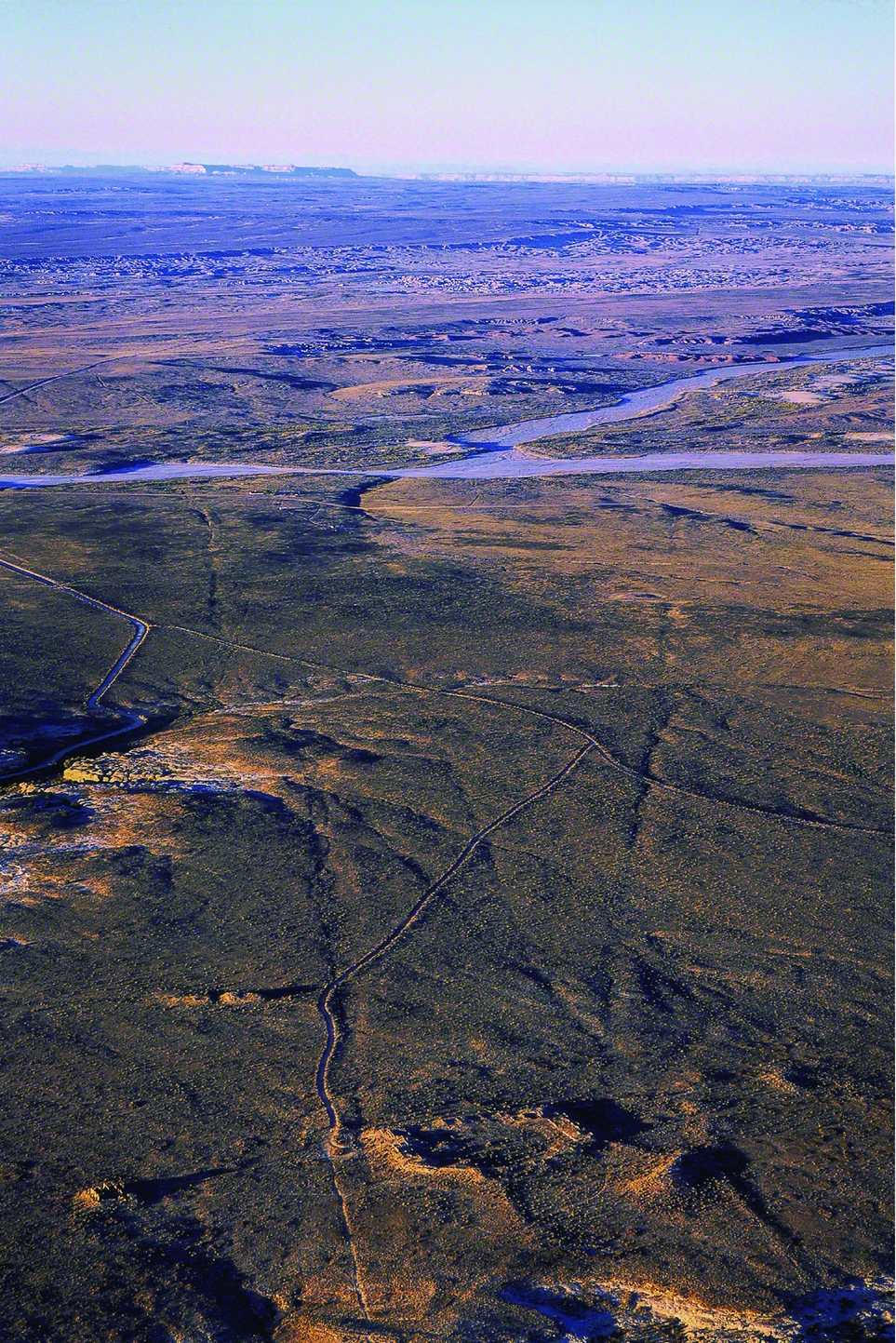
Numerous roads emanating from the Pueblo Alto Great House as documented by low sun angle aerial photography (© Adriel Heisey).
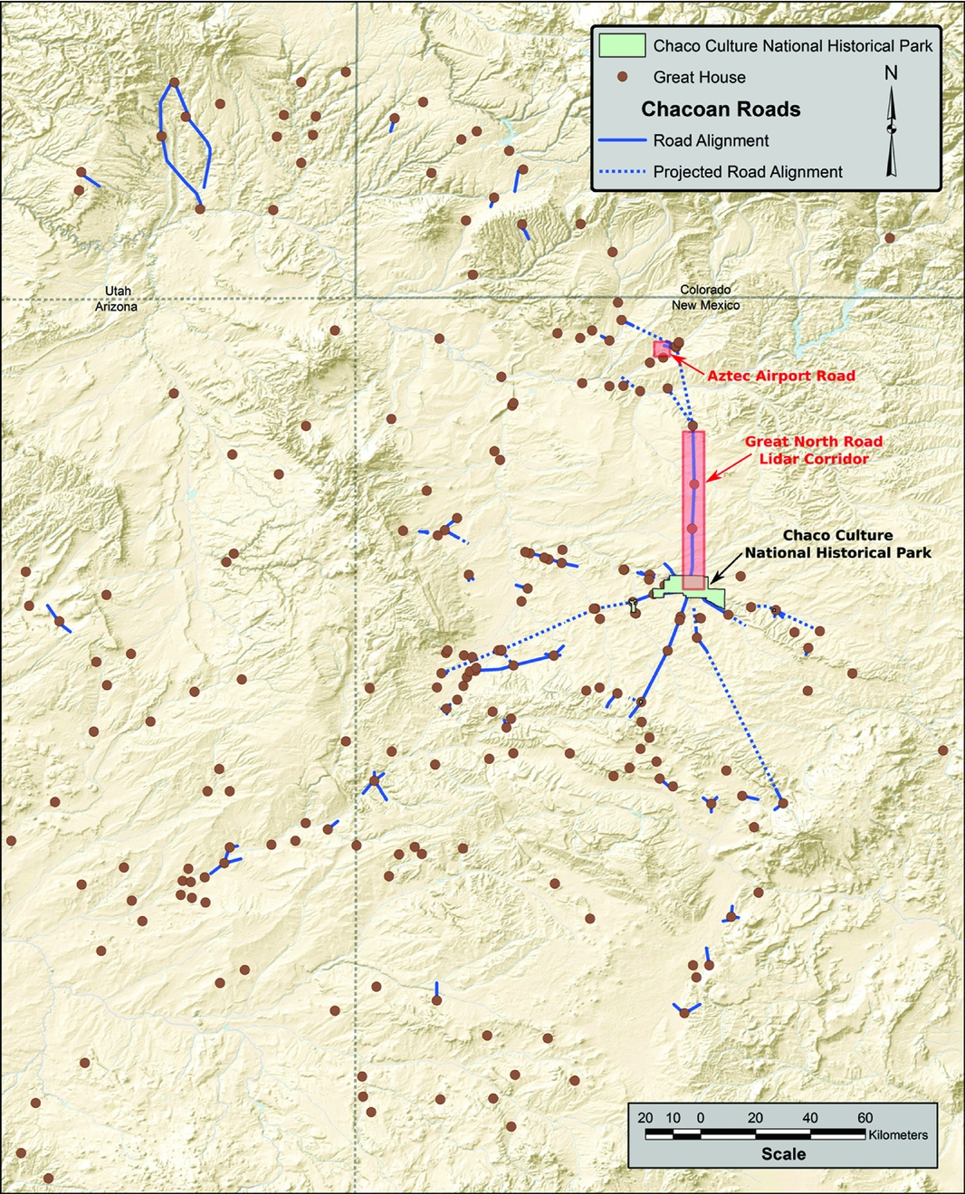
Map of the 100,000 km2 region of Chaco Great Houses and roads, with study areas indicated in red. Note that numerous Chaco roads are short (i.e., less than 1 km in length) and therefore do not appear at the scale of this regional map (map by Richard Friedman with contributions from John Stein, Winston Hurst, Jonathan Till, and John Kantner).
In 1987, archaeologists involved in the Bureau of Land Management's (BLM) effort to document Chaco roads predicted that “the location of prehistoric roads will probably require increasing utilization of more specialized, sophisticated, and expensive techniques of discovery with the passage of time” (Nials et al. Reference Nials, Stein and Roney1987:26). Lidar has been proven highly effective in documenting archaeological landscapes in recent years as demonstrated by case studies in Cambodia (Evans Reference Evans2016), the Maya region (Chase et al. Reference Chase, Chase, Weishampel, Drake, Shrestha, Slatton, Awe and Carter2011; Chase et al. Reference Chase, Reese-Taylor, Fernandez-Diaz and Chase2016), Monserrat (Opitz et al. Reference Opitz, Ryzewski, Cherry and Moloney2015), and the American Southwest (Liebmann et al. Reference Liebmann, Farella, Roos, Stack, Martini and Swetnam2016). Our use of lidar to record the comprehensively studied 50.5 km Great North Road and Pueblo Alto Landscape (flown in 2010), as well as the lesser-known but monumental Aztec Airport Mesa Road (flown in 2007), demonstrate that lidar has the potential to produce a highly accurate, cost-effective, and quantitatively measurable digital model of the current physical expression of Chaco roads. Our recent lidar documentation successfully detected all previously ground-truthed road segments within these study areas, and also revealed 3.2 km of roads that are not detectable by traditional remote-sensing or ground-truthing methods. Ultimately, we suggest that lidar—in accompaniment with ground-truthing studies and other remote-sensing techniques—should be employed to comprehensively document and study Chaco roads. Such an effort would contribute to understanding and managing these under studied but once elaborately created and highly valued features of the ancient peoples of the American Southwest.
BACKGROUND ON CHACO ROADS
Form
Chaco roads are linear surface anomalies, generally 9 m wide, which often run in straight courses that maintain their linearity across topographic obstructions such as hills, mesas, and canyons (Nials Reference Nials and Kincaid1983:6-27). They were constructed primarily by excavating a roadbed (generally to a depth of 0.1–1 m) and/or clearing rocks and vegetation, and occasionally by surfacing a roadbed with caliche, adobe, cobbles, or flagstone. In rare cases, ancient peoples carved steps in cliff walls as features of roads, constructed linear earthen platforms that created raised roadbeds, or surfaced the topographically unmodified ground (Nials Reference Nials and Kincaid1983:6-24–6-25).
Road edges are often defined by masonry walls, low stone curbs, cairns, earthen mounds, or berms (Nials Reference Nials and Kincaid1983:6-21–6-23). While roads are generally reported as 9 m wide, they in fact range from 1 m wide (as seen at the Newcomb Great House) to 20 m (the Aztec Airport Mesa Road reported upon below). Nials (Reference Nials and Kincaid1983:6-5) found that road widths generally cluster into three groupings—over 11 m, 7–11 m, and 7 m or less. The roads generally show a higher degree of formalization and greater width as they approach great houses and great kivas.Footnote 1 Only a few roads have been found to be long continuous routes up to 55 km; most are short segments often connecting the ritual structures of great houses and great kivas (see Supplemental Figure 1 for a typical example at Padilla Well).
Common features of the roads are elongated linear ceramic scatters deposited in the center of roadbeds that consists of fragments of different pots rather than whole pots dropped and broken in situ (Figure 3). Small crescentic masonry structures with ceramic deposits known as herraduras (considered as shrines), architectural earthen mounds, and ritual-related architecture are commonly associated with roads (Nials et al. Reference Nials, Stein and Roney1987:8–18). However, it was observed that “there is no evidence that the presence of the Anasazi roads encouraged either construction of individual residences or establishment of settlements along the road alignment. There is no evidence that purely domiciliary sites articulate with the roads” (Nials et al. Reference Nials, Stein and Roney1987:25).
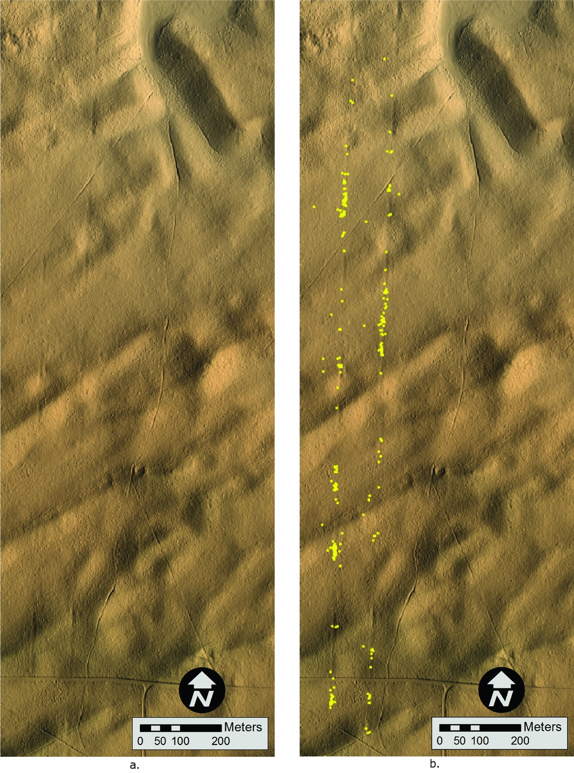
(a) Parallel routes on the North Road detected by lidar, and (b) the same image shown with BLM survey data of ceramic sherd locations demonstrating their concentration in the roadbed (survey data courtesy of James Copeland and Peggy Gaudy of the BLM–Farmington Office).
The construction of ancient roads evolved throughout the Four Corners region, spanning approximately 700 years. Road construction appears to begin with the introduction of the great kiva in the Basketmaker III period (ca. AD 500–700), as numerous roads articulate with these large ceremonial structures. The Basketmaker III site of Two Grey Hills, where roads articulate with architectural features, yielded AMS radiocarbon dates between AD 600–650 (Ruppé et al. Reference Ruppé, Stein, Friedman and Blackhorse2001; Supplemental Figure 2). Tohatchi Village is another example of a Basketmaker III site with roads. Roads are present at Pueblo I sites (ca. AD 700–900) such as Skunk Springs, Pueblo II, or Bonito-style, sites (ca. AD 900–1150), and continue to be constructed until approximately AD 1250 (Fowler and Stein Reference Fowler, Stein and Doyel1992). The varying degrees of formalization in road construction across time and space, as well as differing ground conditions in diverse environments where roads occur, result in a multiplicity of signatures in remotely sensed imagery and ground expressions.
Function
Early interpretations of Chaco roads posited that they served as integrating transportation corridors for the movement of goods and people (Betancourt et al. Reference Betancourt, Dean and Hull1986; Ebert and Hitchcock Reference Ebert, Hitchcock, Lyons and Mathien1980; Judge et al. Reference Judge, Toll, Gillespie, Lekson and Schroeder1981; Powers et al. Reference Powers, Gillespie and Lekson1983; Windes and Ford Reference Windes and Ford1996). However, much subsequent work has argued against this interpretation (see Vivian Reference Vivian1997b:43–47 for a full review of economic models and others). Roads often ignore topographic obstacles, and they were built on a scale beyond requirements to facilitate transport of goods or populations, especially in consideration of the absence of pack animals or wheeled vehicles among the ancient inhabitants of the Four Corners region. Some propose, however, that some of the longer roads may have served travel and transportation purposes.
For example, the 55 km South Road has been proposed as a route for the transport of timbers from Lobo Mesa into Chaco Canyon, though ground surveys show discontinuities in the alignment (Marshall and Roney Reference Marshall and Roney2012). While some have proposed a constructed trans-basin West Road extending from Chaco Canyon to the Chuska Mountains as a source location for timbers, Chuska ceramics, Narbona Pass chert, and maize, recent surveys have revealed no evidence of Chaco road construction extending across the West Basin in this area (Michael P. Marshall, personal communication 2017). In southeastern Utah's Comb and Cottonwood Washes, however, Chacoan roads appear to link six great houses (Hurst and Till Reference Hurst, Till and Cameron2009). Some investigators suggest that roads were used for pilgrimage into the ceremonial buildings of Chaco Canyon (Judge Reference Judge, Cordell and Gumerman1989; Van Dyke Reference Van Dyke2007). As evidence against large-scale pedestrian travel on Chaco roads, trenches excavated by the BLM in historic roads/two-tracks that had seen significant usage all had a zone of platy structure (caused by compaction due to surface travel) directly beneath the surface, whereas not a single excavated prehistoric road trench revealed platy structure (Nials Reference Nials and Kincaid1983:6-47–6-49).
Vivian (Reference Vivian1990; Reference Vivian1997b:50–51, 61) sees roads as establishing symbolic and physical unity between great houses participating in a Chaco-based system. However, in the last review of all known road segments, Roney (Reference Roney and Doyel1992:125) demonstrated that most “are short segments that begin at a Chacoan outlier and have no obvious endpoint. . . [and] often do not clearly link the Bonito-style buildings to one another.” Of the roads included in Roney's (Reference Roney and Doyel1992) synthesis, 92% are less than 5 km in length, and 57% are less than 1 km, though the possibility of further length to these segments should be evaluated using new technologies. He suggests that while the North and South Roads are clearly of regional scale and associated with Chaco Canyon, most roads appear to be localized phenomena. He posits a function for roads as one further component of integrative great house complexes and as labor projects that could contribute to social cohesion (Roney Reference Roney and Doyel1992:130). Stein and Lekson (Reference Stein, Lekson and Doyel1992) elaborate upon the ideological and integrative nature of roads, framing them within the concept of Chacoan ritual landscapes. Building on this work, Kantner's (Reference Kantner1997) GIS analysis showed that road segments in the Lobo Mesa area do not fall on least-cost paths, but instead most commonly connect the ritual structures of great houses and great kivas or represent alignments to prominent landscape features.
Lekson (Reference Lekson and Lekson2006:33–35), however, maintains that roads are best understood as long, continuous corridors and that suggestions of roads as fragmentary and ceremonial have been too easily accepted. Additionally, some propose that a small domestic community accompanying the monumental public architecture at Pierre's Complex may provide evidence of a utilitarian purpose for the North Road. Other researchers argue that some linear surface anomalies have been misinterpreted as roads and should instead be understood as irrigation canals (Janes Reference Janes2005; Wills and Dorshow Reference Wills and Dorshow2012) or corridors for rolling construction timbers to Chaco Canyon (Weinig Reference Weinig2016).
One purpose of roads appears to have been to materialize symbolic connections between non-contemporaneous sites. Fowler and Stein (Reference Fowler, Stein and Doyel1992) present evidence that several roads associated with Chaco great houses in Manuelito Canyon (128 km to the southwest of Chaco Canyon) may have served as “time bridges” connecting sites of different eras (usually eleventh- and twelfth-century sites to thirteenth- and fourteenth-century sites)—perhaps as a means to express a symbolic union with ancestral entities. Roads connecting sites across centuries typically link great kivas with later great houses, such as at Padilla Well (see Supplemental Figure 1), Kin Ya'a (Marshall and Roney Reference Marshall and Roney2012), and Red Willow (Marshall and Sofaer Reference Marshall and Sofaer1988; Van Dyke Reference Van Dyke, Van Dyke and Alcock2003).
Sofaer and colleagues' (Reference Sofaer, Marshall, Sinclair and Aveni1989) study of the 50.5 km Chaco Great North Road suggested that it was built to align Chaco Canyon with the direction north while also incorporating a connection with the distinctive badlands topography of Kutz Canyon in a cosmographic expression. Numerous routes ascend the cliffs behind the central canyon great houses and converge at Pueblo Alto. From Pueblo Alto, the road heads north within a quarter of a degree of accuracy and traverses one of the least developed areas of the Chacoan cultural region. The absence of large population centers, camping sites, resources, or evidence of trade along the road suggests that it was “overbuilt and underused” (Sofaer et al. Reference Sofaer, Marshall, Sinclair and Aveni1989). The only major Chacoan site along the road is Pierre's Complex, “a constellation of special-function architecture” built onto “the summits of precipitous buttes and pinnacles” (Stein Reference Stein and Kincaid1983:8-9). One portion of the North Road (like several others) exists as parallel routes, each 9 m wide (Marshall Reference Marshall, Morrow and Price1997:68–69; Sofaer et al. Reference Sofaer, Marshall, Sinclair and Aveni1989). From Pierre's Complex, the road appears to intentionally deviate from astronomic north in order to terminate at the steepest edge of Kutz Canyon, where a stairway was found with a concentration of broken ceramics.Footnote 2
Insights into the North Road's possible symbolic significance are suggested by descendant Pueblo people. North holds great importance in Puebloan cosmologies as the place of emergence and return of the spirits of the dead (White Reference White1942:77, Reference White and Diamond1960:89). In the Tewa culture and language, “road” translates as “channel for the life's breath” (Alfonso Ortiz, quoted in Sofaer et al. Reference Sofaer, Marshall, Sinclair and Aveni1989), and the image of two parallel roads conveys the relationship between the living and the dead (Ortiz Reference Ortiz1969:57). The cultural significance of the Great North Road and its fragility were recognized in 2011 by the National Trust for Historic Preservation in designating the Greater Chaco Landscape as one of the Eleven Most Endangered Places for that year.
Other evidence shows that Chaco roads served as symbolic articulations with important landscape features. The 55 km South Road leading out of the central canyon terminates at towering Hosta Butte, and the 10 km Ah-shi-sle-pah Road leads to the ephemeral pond of Black Lake (Sofaer et al. Reference Sofaer, Marshall, Sinclair and Aveni1989). Other Chaco roads—often short segments emanating from great houses in a “spoke-like” configuration—appear to align with distinctive landscape features, including lakes, caves, springs, pinnacles, and buttes (Marshall Reference Marshall, Morrow and Price1997). A road at the Skunk Springs Great House is oriented to the winter solstice sunrise in another example of the cosmographic nature of roads. It is important to be aware of both the physical and conceptual significance of Chaco roads as we use lidar to document and preserve them.
A BRIEF HISTORY OF CHACO ROADS RESEARCH AND IDENTIFICATION METHODSFootnote 3
Chaco roads research has evolved in parallel with developments in remote-sensing technologies for archaeological research, with lidar scanning as the most recent and cutting-edge methodology. The recognition of Chaco roads is enhanced by their unique qualities: a rigorous linear or sweeping curvilinear nature (some shaped as large circles and ovals), straight trajectories going over/through (rather than avoiding) natural obstacles, and having greater widths than other linear features such as the tracks of automobiles and wagons.
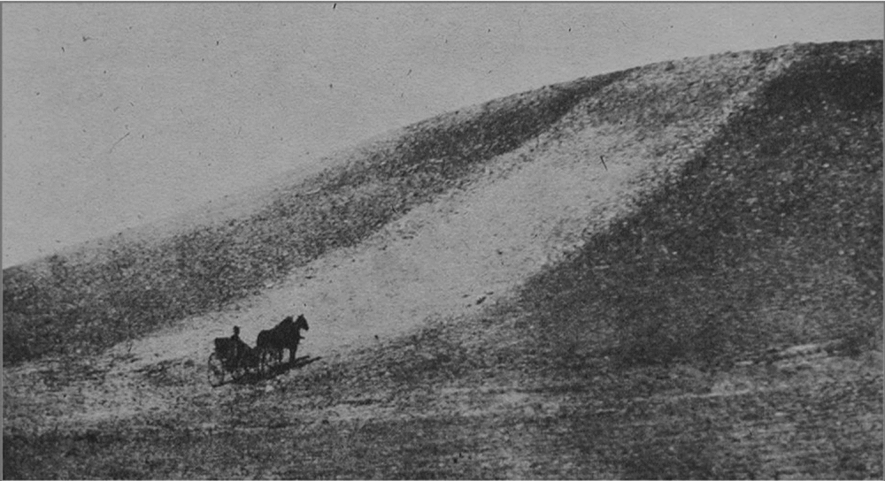
The first accounts of roads date from the late nineteenth and early twentieth centuries, describing road segments at Pueblo Pintado (Morrison Reference Morrison1876:360) and between Chetro Ketl and Pueblo Alto (Holsinger Reference Holsinger1901:67–68). A Reference Walter1916 photograph of the Aztec Airport Mesa Road (described below) demonstrates how much more visible roads were only 100 years ago and suggests the impressive, monumental character of roads during the Chaco era (Figure 4).
The Aztec Airport Mesa Road in 1916. Note the monumental scale and white surface treatment (Wadleigh Reference Wadleigh1916:52).
Early research on roads was conducted by the National Park Service Chaco Center's Remote Sensing Unit (Lyons and Hitchcock Reference Lyons, Hitchcock, Lyons and Hitchcock1977; Obenauf Reference Obenauf1980). Due to proposed coal development in the San Juan Basin, the BLM initiated the first large-scale effort to systematically document Chaco roads in the 1980s. The study had numerous goals—to document segments previously encountered on the ground, to ground-truth segments previously identified in aerial imagery, and to investigate new segments revealed by analyzing various sources of aerial imagery (Kincaid Reference Kincaid1983; Nials et al. Reference Nials, Stein and Roney1987).
Recognition criteria for the identification of Chaco road segments via remotely sensed imagery include linear breaks in topographic trends, rock and/or debris alignments, changes in natural drainage patterns, linear vegetation anomalies (which become especially pronounced with increased vegetation growth in early spring or late summer), linear low sun angle light/shadow anomalies, linear texture anomalies, and linear infrared/thermal anomalies. In aerial photographs and on the ground, roads often appear discontinuous due to varying topographic and depositional/erosional environments as the roads move across the landscape. For example, the Great North Road is quite visible where it crosses ridges created by stabilized longitudinal dune fields, but physical manifestations of it are impossible to see where it crosses low areas between dunes.
Aerial photographs of a nominal scale of 1:40,000 taken by the Soil Erosion Service (SES) in 1934 and U.S. Geological Survey (USGS) in the 1950s and 1960s were and continue to be an important data source for Chaco roads research. The SES images are particularly useful because they were taken at a time of lower population with fewer landscape disturbances (e.g., historic roads) and generally at a relatively low sun angle. Unfortunately, SES images are of fairly low resolution (approximately 1 m). Additionally, data on the exact camera set-up and geometries and how the composite photos were made are unavailable.
In 1981, low sun angle stereo aerial photographs commissioned by the BLM of some of the road study areas confirmed that low angle light photography greatly enhanced the visibility of roads in aerial photographs (Obenauf Reference Obenauf and Kincaid1983). To analyze these images, Margaret Obenauf and other BLM researchers used a mirror stereoscope with magnifying lenses mounted on a scanning track, which exaggerated linear depressions in the photographs (Obenauf Reference Obenauf and Trombold1991). Aerial reconnaissance in fixed wing aircraft in early morning or late evening was also a helpful method of road detection by the BLM (Nials et al. Reference Nials, Stein and Roney1987). In a 1982 collaborative effort with the National Aeronautics and Space Administration (NASA), a Thermal Infrared Multispectral Scanner (TIMS) was employed to detect Chaco roads and found to be relatively effective with the proper ground/field conditions (Sever and Wagner Reference Sever, Wagner and Trombold1991). National Agriculture Imagery Program (NAIP) photography captured in early morning conditions in 2005 is an additional valuable source of aerial imagery to detect Chaco roads.
Evidence of a road on the ground can consist of subtle linear depressions or swales in the ground surface, border elements such as stone curbing or low masonry walls, minor changes in vegetation within the roadbed, and elongated linear scatters of ceramics within the road margins. The presence of shrine-like herraduras also can suggest a road. Additionally, cobble- to boulder-sized stones of non-local geological types present along road margins, and/or the presence of rocks with caliche coating on the upper surface in roadbeds, are also possible identifiable features of roads (Nials Reference Nials and Kincaid1983:6–23).
The Deterioration of Chaco Roads over the Past Century
Many of the ancient roads that were highly visible in aerial photography captured in the 1930s and still detectable on the ground in surveys conducted in the 1980s are now visible only by using lidar technology. On a daily basis, the forces of nature are working to bring the surface of the earth to a state of equilibrium—a flat plain. Wind, rain, snow, frost, and vegetation growth/loss are constantly contributing to the destruction of traces of Chaco roads in the Four Corners region, the pace of which has accelerated in recent decades. Overgrazing also affects Chaco roads by removing surface vegetation, causing more rapid and higher volume runoff, as well as the transport of larger quantities of windborne sediments. The development of energy-extracting facilities and infrastructure in the Four Corners region is also impacting the fragile Chaco roads. Preliminary attempts at defining a model to predict the factors influencing road deterioration in particular areas (e.g., soil erodibility by water and wind, precipitation levels, temperature) are intriguing but inconclusive (Clark and Fritschle Reference Clark and Fritschle2011).
Quantifying the deterioration of Chaco roads is a complicated and massive undertaking beyond the scope of this paper, involving the comparison of numerous forms of aerial photography and other remote-sensing data collected under different environmental conditions along with extensive ground survey. For example, certain road segments with minimal vertical relief are best detected using vegetation patterns or soil moisture; thus, such roads can appear to have “disappeared” in certain forms of aerial imagery due to the time of year that the images were made. Additionally, the erasure of visible physical traces of Chaco roads is due mostly to surface erosion and/or deposition, yet previous methodologies were unable to efficiently measure the depth or cross-sectional surface profiles of Chaco roads—making a comparative quantitative assessment of road deterioration impossible prior to the use of lidar to collect precise measurements of road depths. For these reasons, we focus on various visual case studies supplemented by field observations to describe the deterioration of various road segments that we have documented using lidar.
LIDAR DOCUMENTATION OF THE AZTEC AIRPORT MESA ROAD
An analysis of the Aztec Airport Mesa Road (~1.6 km west of Aztec Ruins National Monument)—conducted by the first author using lidar data captured in 2007 by a consortium of San Juan County, the City of Farmington, New Mexico, and the City of Aztec, New Mexico—illustrates the deterioration of the expression of Chaco roads over the past 100 years. In 1916, the Aztec Airport Mesa Road was a dominant and clearly visible feature on the landscape, “marked with pebbles and boulders” and finished with a white (possibly clay) surface treatment (Figure 4; Wadleigh Reference Wadleigh1916:52). This same road segment, though not as obvious as in the 1916 photo, is still clearly visible in 1934 aerial photographs (Figure 5a). Although it was noted in 1960 that the construction of a gas line was causing damage to the road (Hastings Reference Hastings1960:72), it was still easily identifiable on the ground in the late 1970s to early 1980s (Fred L. Nials, personal communication 2010). But, today, it is comparatively difficult to detect traces of this road on the ground (Fred L. Nials, personal communication 2010) or in contemporary standard aerial photography (Figure 5b).
(a) The Aztec Airport Mesa Road in Soil Erosion Service aerial photography from 1934; (b) 2009 Google Earth Imagery; (c) lidar data; and (d) the road's cross-sectional profile as documented by lidar.
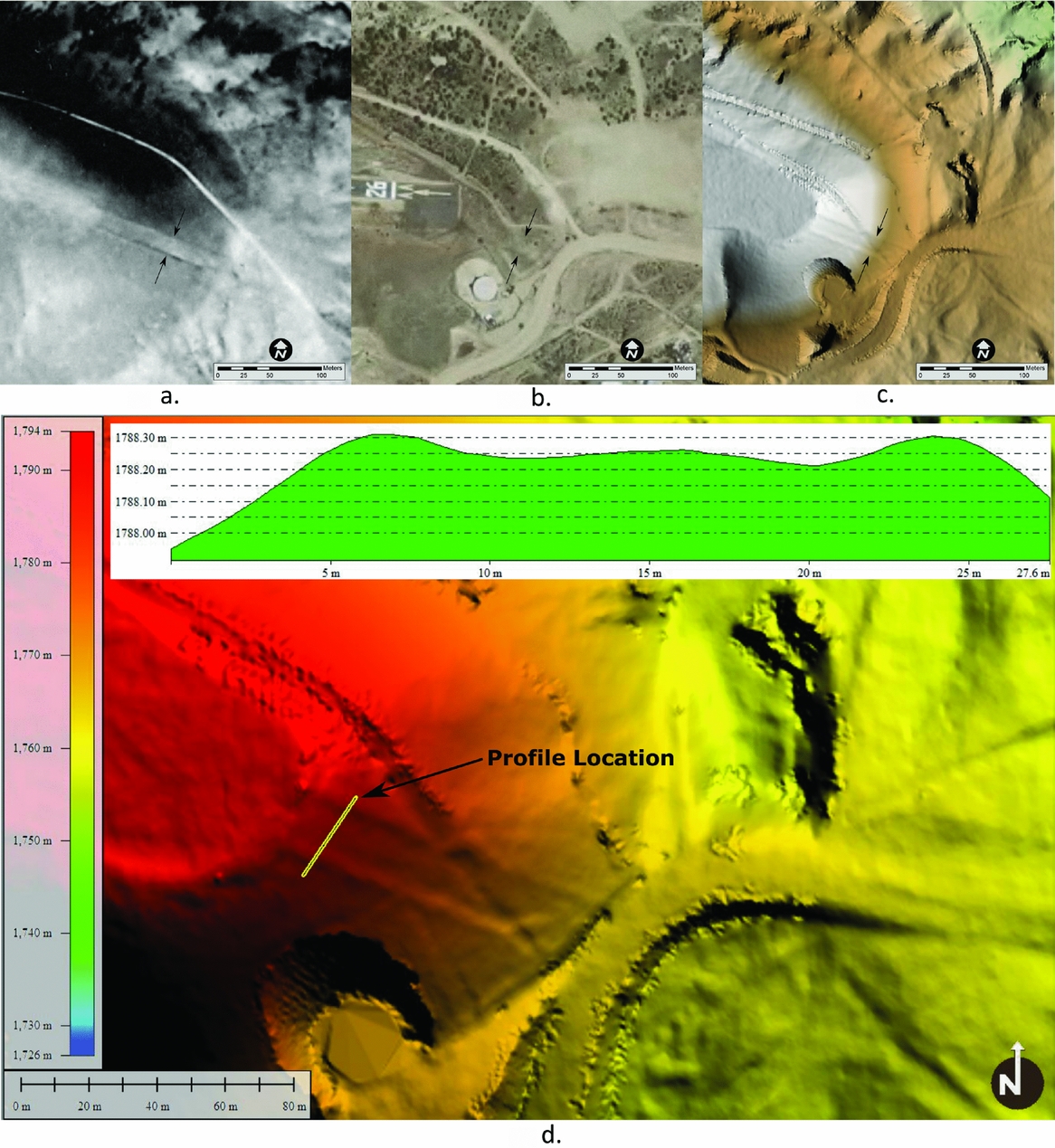
The 2007 lidar data, however, not only clearly shows the Aztec Airport Mesa Road segment (Figure 5c), but allows one to construct its extant cross-sectional profile with an unprecedented degree of precision (Figure 5d). Therefore, while previous reports listed the width of the road as 10 m (Walter Reference Walter1916:52) or 16.7 m (Hastings Reference Hastings1960:72), lidar allowed us to measure the width of the road as it ascends the mesa more accurately as 20.8 m and its maximum depth (a measure that cannot be collected with any other method) as 10 cm. This preliminary work demonstrated lidar's capability to precisely document Chaco roads and led us to initiate a larger study of the Great North Road.
THE SOLSTICE PROJECT NORTH ROAD LIDAR PROJECT
In 2010, the Solstice Project was awarded a grant by the National Trust for Historic Preservation to document Chaco's Great North Road using lidar. We chose this road to further test lidar's utility in roads research for several reasons—the extant corpus of rich documentation by the BLM (Stein Reference Stein and Kincaid1983) and Solstice Project (Marshall and Sofaer Reference Marshall and Sofaer1988; Sofaer et al. Reference Sofaer, Marshall, Sinclair and Aveni1989), the road's cultural significance to descendant Pueblo people (interviews in Sofaer Reference Sofaer1999), and the alarming encroachment of energy development on and near the road. By using lidar to document the Great North Road, we could both (1) test its effectiveness to detect previously documented road segments and (2) determine if lidar could detect previously undocumented roads in a heavily studied area.
Bohannan Huston Inc. was selected as the lidar contractor for the project. The Solstice Project chose to acquire raw unfiltered lidar data to maximize the area of data that could be collected with the available funds. Given the dominance of low, sparse vegetation in the project area, unfiltered data would allow initial analysis in many sections prior to creating a bare earth model. Additionally, the availability of Free and Open Source Software (FOSS) tools for the processing of lidar data like GRASS and Aldpat enabled in-house filtering of non-ground features at no additional capital costs. By taking this approach, the Solstice Project's lidar documentation covered the entire span of the Great North Road from Chaco Culture National Historical Park to where it enters Kutz Canyon, a distance of 50.5 km.
METHODS
Airborne lidar, also known as airborne laser scanning, is conducted by mounting a laser scanner and the associated data-recording equipment in a plane, helicopter, or, more recently, an Unmanned Aerial System (UAS, more commonly known as a “drone”). While the aircraft flies over the target area, the onboard equipment records the time it takes for a laser pulse to be reflected by the ground or an object on the ground back to the aircraft. The onboard equipment also records additional information about the aircraft's position and orientation in 3-D space. This locational data, when combined with the data from the laser scanner, is used to compute the location in 3-D space of the ground/object that reflected the light pulse. The resulting product is referred to as a point cloud and can be used to create a highly accurate 3-D model of the surface flown by the aircraft.
Airborne lidar is currently the most accurate method of creating digital elevation models (DEM) and can “penetrate” vegetation or tree canopy where photogrammetric methods typically cannot resolve the elevation of the ground surface. The point cloud data can be used to create digital surface models (DSM) and digital terrain models (DTM, also known as bare earth surface). DTMs can be used to reveal features such as rivers, paths, ancient architecture, or Chaco roads that are concealed by trees or other vegetation.
We used several processing steps to produce the best possible bare earth DTM for Chaco road analysis. The lidar data delivered by Bohannan Huston Inc. was “raw” unfiltered binary .las last pulse point data at a nominal point spacing of 1 m. We tiled the data to approximately 3 million points per tile for the four flight lines of data. We mosaicked and reclipped the original tiles for each flight line into overlapping tiles with straight boundaries on the north and south edges conforming to grid north for the coordinate system being used (New Mexico State Plane, West Zone, North American Datum of 1983, US Feet). The tiles were then imported into GRASS GIS software for filtering to prepare a bare earth surface model, creating derivative datasets that were then used in applying an edge detection filter, region growing filter (infill edges on structures/trees), and point classification. We then created a bare earth surface model, which was exported from GRASS to an intermediate ASCII xyz point file. The xyz point file was converted to a DEM raster using triangulation in Global Mapper and saved as a binary raster data set (binary .flt/.hdr files). The binary raster .ftl/.hdr files were imported into Manifold GIS as surfaces. We then used a customized Low Pass filter in Manifold designed to attenuate high frequency noise created by low vegetation that had not been removed by filtering in GRASS. Finally, requiring approximately 12–16 hours for processing each tile, mosaics of the bare earth DTM were created. Our last step was to apply hill shading and color gradients to the bare earth DEM for visual analysis.
We performed all processing steps on datasets composed of individual flight lines to avoid any visual “noise” in the surface models due to minor differences in the point elevation values in overlapping portions of flight lines. Due to the extremely subtle nature of Chaco road segments, increased noise due to very minor variations in elevation values will make visual identification of the road more difficult.
RESULTS
Analysis of the bare earth DTM generated from lidar data using manipulation of the direction (azimuth) and angle above the horizon of the light source proved a highly effective method for detecting, documenting, and measuring Chaco roads. All segments of the North Road documented in previous studies were markedly pronounced in the lidar data, despite the fact that many of these segments are currently virtually invisible on the ground and/or in aerial photography. Additionally, using lidar we detected 3.2 km of previously undocumented road segments along the corridor of the Great North Road. Lidar, therefore, has the capacity both to discover new road segments and to archive previously recorded Chaco roads with a higher degree of quantitative precision in length, width, depth, and cross-sectional profile measurement data than is possible with any previous methodology.
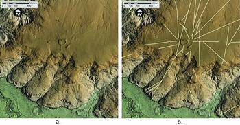
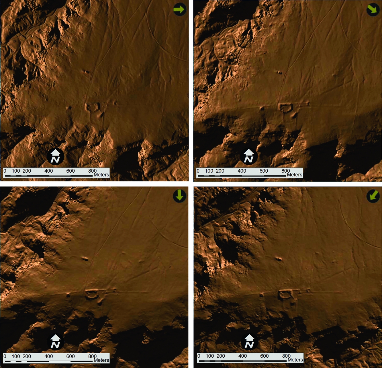
Shadow enhancement has been used in Chaco roads research for years, but there is a limited directional range that it can occur in nature—the sun rises only in the east and sets only in the west. Therefore, roads trending in a predominantly north-south direction are readily enhanced by low sun aerial photography, but those trending predominantly east-west will receive very minor or no shadow enhancement. However, in a digital GIS environment, the light source can be manipulated to simulate the sun rising or setting from any direction. This capability allows researchers to identify potential roads trending at all angles (Figure 6). The ability to create shadow enhancement from any virtual sun azimuth or altitude gives Chaco roads researchers a more flexible and cost-effective tool than traditional low sun angle photography.
Different “sun angles” applied to lidar data of the Pueblo Alto Landscape. Note how roads with different trajectories are sharpened by different light angles. The arrow in the upper right shows the direction of the light source.
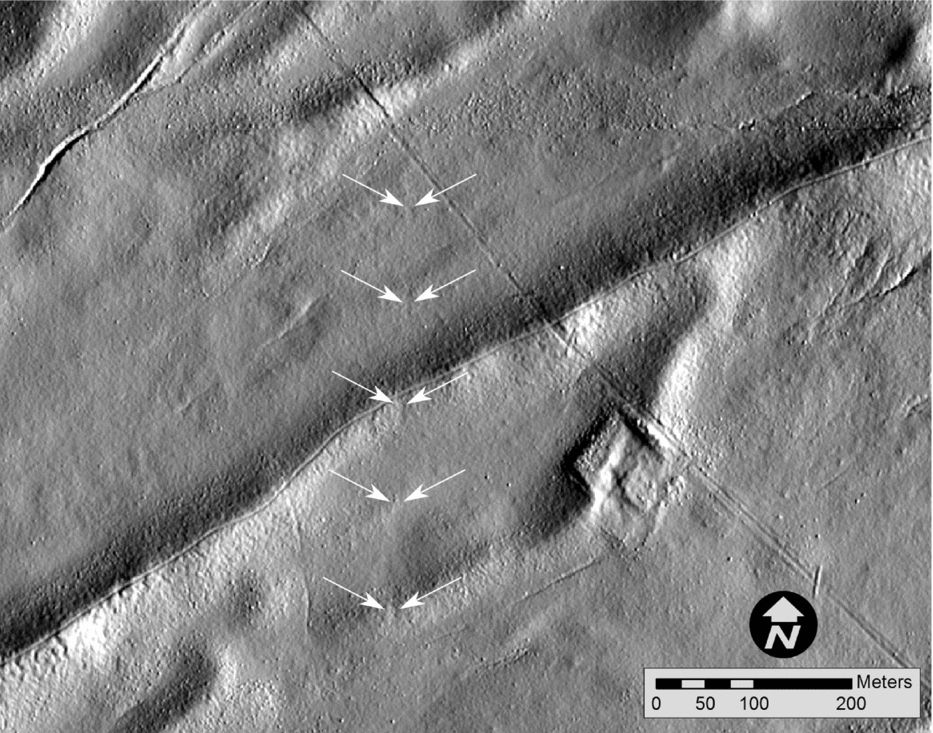
We were also able to use the lidar data to measure and quantify the morphology of Chaco roads at centimeter levels of relative vertical precision, which is not possible using traditional methods. For example, Figure 7 shows the cross-sectional profile of a previously undocumented segment of the North Road that, due to the fact that it has only 9.1 cm of vertical relief across a distance of approximately 9.5 m, could never be seen on the ground, and therefore the morphology could not be measured in the field. Yet, it is easily discernible using lidar data.
20× exaggerated vertical profile of a section of the North Road detected by lidar that is not visible on the ground.

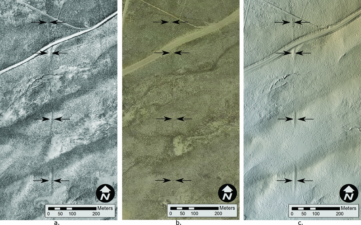
A segment of the Great North Road approximately 2.4 km south of Pierre's Complex, a Chaco outlier, provides another example of lidar's utility for documenting the deterioration of Chaco roads. During the 1980s BLM surveys, this segment was clearly visible on the ground (Fred L. Nials, personal communication 2010), yet the road is now quite difficult to discern other than the appearance of a slight swale on the horizon. The visibility of the road from the air has also significantly decreased. This segment was readily visible in the 1981 BLM Low Sun Angle aerial photography, but virtually invisible in aerial photography taken in 2009 (Figures 8a and 8b). Like the Aztec Airport Mesa Road, this segment that was invisible in 2009 aerial photography can now be visually identified and quantitatively documented with lidar data (Figure 8c).
A segment of the Great North Road shown in aerial photographs from (a) 1981 with low sun angle; (b) 2009 with standard sun angle; and (c) shadow-enhanced lidar.
Finally, our lidar scan of the North Road revealed 3.2 km of sections of the Great North Road that had gone unnoticed in all previous studies of this comprehensively surveyed road. As one example, Figure 9 shows lidar imaging of a 450 m long section of shallow swales crossing the crests of stabilized Quaternary longitudinal dunes in an area of the projected North Road corridor where no traces had previously been identified. Naturally, the next step was to ground-truth these suspected road segments to verify their anthropogenic origin. The San Juan College Archeological Field School performed ground-truthing on this road segment in 2014 using GPS to map pottery sherd scatters. Elongated linear sherd scatters were aligned perfectly with the traces identified in the lidar data (Linda Wheelbarger, personal communication 2014; for a similar visual example, see Figure 3).
Lidar image of a previously undetected segment of the North Road.
The road segments we have reviewed so far have been on public lands with permissive uses, so we were curious whether road segments located within the protected area of Chaco Culture National Historical Park would demonstrate a similar loss in visibility over the last 70 years. To answer this question, we analyzed a landscape near the beginning of the Great North Road to the north and east of the Pueblo Alto Great House.
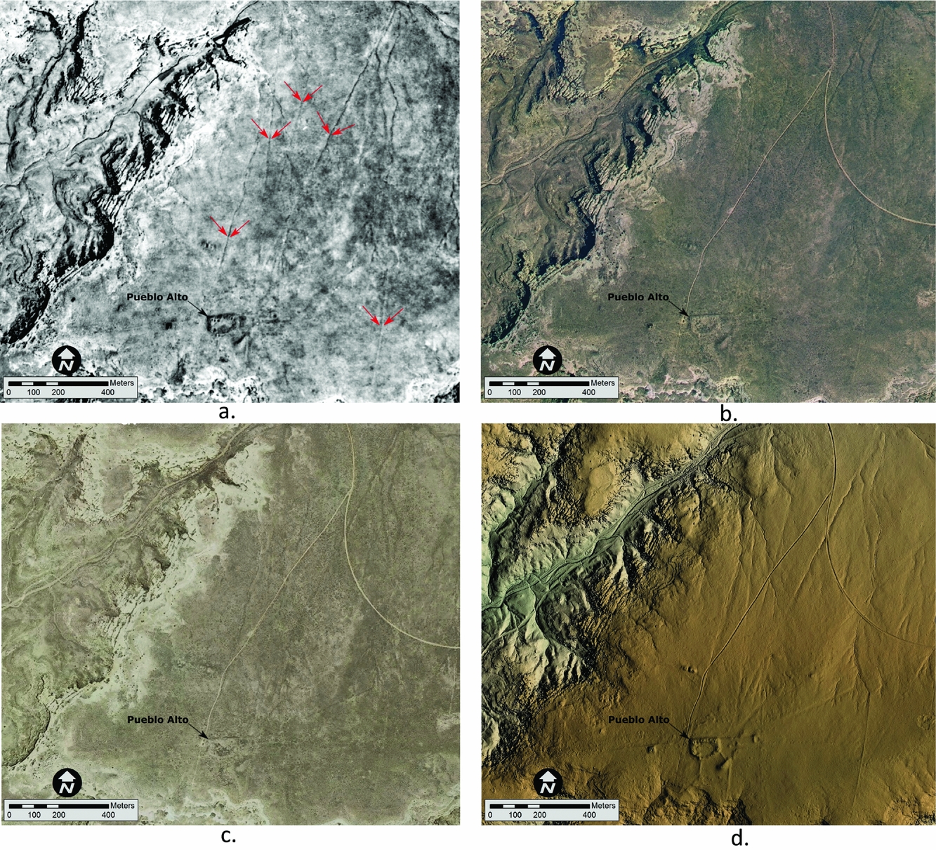
Many of the roads in the Pueblo Alto Landscape are visible in an aerial photograph by Fairchild SES Aerial Surveys in 1934 (Figure 10a). But by 2005, the roads were much more difficult to see even with low sun angle photography (Figure 10b). In traditional (not low sun angle) aerial photography from 2009, many of the roads are imperceptible (Figure 10c). This series of images illustrates the rapid deterioration of roads from natural processes, even within the protected boundaries of Chaco Culture National Historical Park. We could detect no visual distinction in the amount of deterioration between Chaco roads within the park boundary and those on BLM land (compare Figures 8 and 10), suggesting the urgency of documenting all areas where Chaco roads may be present, regardless of their use restrictions.
The Pueblo Alto Landscape as documented through various remote-sensing methods, including (a) 1934 Soil Conservation Service aerial photography; (b) 2005 with low sun angle NAIP photography; (c) 2009 with standard sun angle; and (d) hillshaded lidar. Arrows are marking the road in Figure 9a. Note the vast decrease in visibility over time and the clear definition of roads in the lidar image.
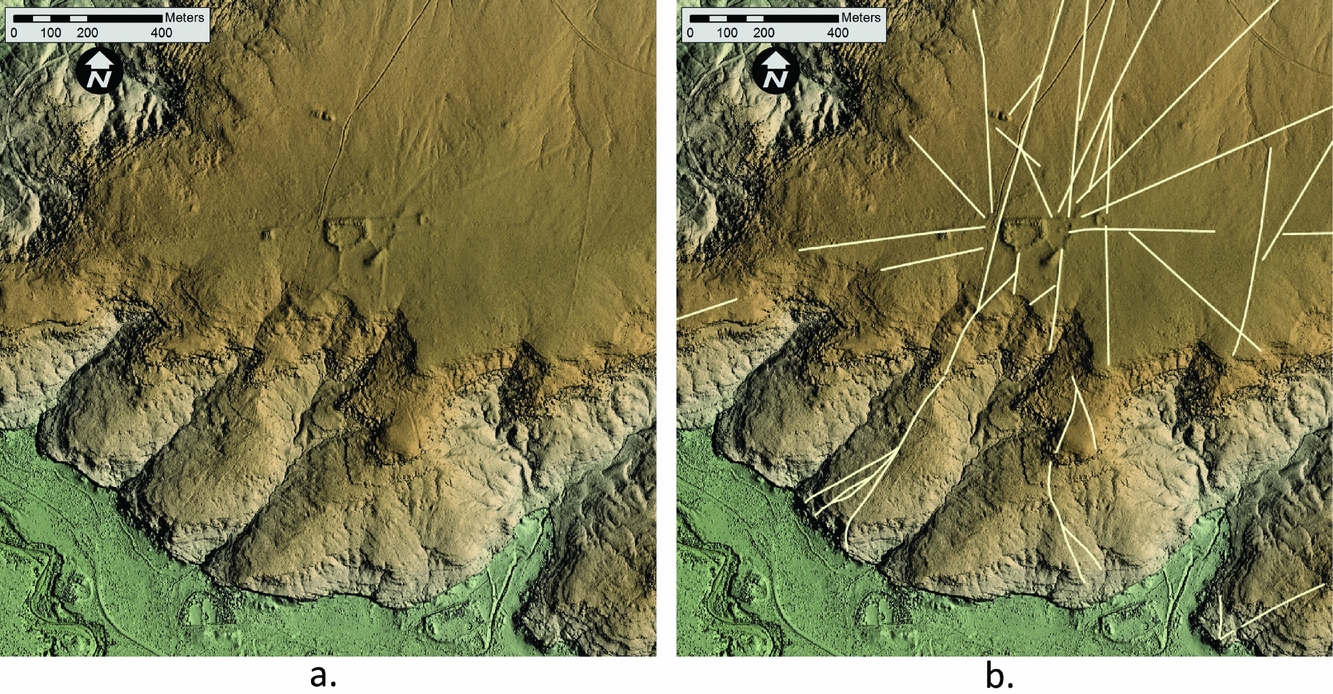
While the visibility of roads clustered around Pueblo Alto has rapidly diminished, lidar has proven a highly effective method of detecting and quantitatively documenting these features (Figures 10d and 11a–b). Lidar data successfully detected all segments that were obvious in the 1934 aerial photography and aided our identification of other roads not perceptible in these same photographs. As described above, the ability to change the sun angle using GIS has been critical for the recognition of two road segments running south from Pueblo Alto, which do not appear in any previous imagery.
(a) Alternate view of hillshaded lidar image of the Pueblo Alto Landscape, (b) with road segments marked.
Overall, we emphasize that our lidar study of the North Road, Pueblo Alto Landscape, and Aztec Airport Mesa Road demonstrates the efficacy of this technology for the detection and quantitative digital documentation of Chaco roads. Lidar data provides the opportunity to measure the length, width, depth, and cross-sectional profiles of road segments at an unprecedentedly high level of accuracy and precision. Additionally, the ability to manipulate the position of the light source within a GIS environment allowed us to detect roads with trajectories not enhanced by natural sun angles. Lidar documentation and analysis, therefore, opens new frontiers for research and preservation of Chaco roads, many of which are no longer easily detected using traditional methodologies.
CONCLUSION
The Solstice Project's lidar documentation of Chaco roads demonstrates that this technology has unprecedented capability for detection, documentation, and management of roads throughout the Chaco region, even if those roads are not currently visible in aerial photography or were never perceptible on the ground. These features are rapidly deteriorating from the impacts of natural weathering and human encroachment over the last century, including recent energy development. In the case of the Great North Road, modern roads to facilitate energy development have disturbed its course, and proposed increases in this activity threatens further disturbance to this and other ancient roads. The continuing demand for natural resource extraction in the greater Chaco landscape—including oil, gas, coal, and grazing land—as well as severe droughts and rainstorms of recent history have created an increased rate of sedimentation and erosion.
Recognizing these threats to Chaco roads and their rapidly decreasing ground signatures, we suggest several directions for future work to build effectively on the results of our lidar scan of the Great North Road. The high-precision quantitative data on road length, width, depth, and cross-sectional measurements provided by lidar can serve as an invaluable resource for future research and monitoring their deterioration over time. To create an archival record at this critical time, comprehensive lidar scanning of the entire region where ancient roads are suspected—approximately 100,000 km2 of the Four Corners region—should be a priority. We note that the BLM Farmington Office recently commissioned a lidar scan of 4,247 km2 surrounding Chaco Canyon where energy development had been proposed. Additionally, the USGS, in collaboration with the BLM, has also recently acquired lidar data in a region near La Plata, Colorado, where numerous Chacoan sites are known. Our preliminary analysis of these datasets has yielded approximately 4 km of previously undetected possible road segments; further analysis and ground-truthing of these roads by the Solstice Project is in progress. While these new data will provide an important opportunity to document roads in actively threatened areas, we emphasize that the whole Chacoan cultural region must be encompassed in a large-scale, systematic lidar study.
To evaluate the results of lidar scanning, ground-truthing of newly discovered potential road segments is essential and should be prioritized in areas of potential shift in land uses. Individuals trained in the subtle art of road recognition should conduct these analyses, as the full suite of skills necessary for ground-truthing Chaco roads will be especially necessary in investigating the increasingly subtle traces of roads revealed by new remote-sensing techniques. As described throughout this paper, a complex, holistic set of interlocking skills is necessary for the nuanced investigation of Chaco roads, including analysis of aerial photographs and other remotely sensed data, ground-truthing, and training in geology to recognize unnatural drainage patterns and rock types that do not naturally occur within a given environment. Since only a few Southwestern archaeologists have the long-term experience and capability to identify roads on the ground, they themselves should train a new generation of archaeologists in the full suite of methodologies for Chaco roads study. Finally, we wish to emphasize that a comprehensive Chaco roads study should include an analysis not only of landscapes associated with Bonito-era great houses, but of all large sites/complexes from the Basketmaker III to Pueblo III periods where roads identified in previous studies have often been overlooked.
Accurate and comprehensive information about ancient roads of the Four Corners region will contribute invaluably to our understanding of the cultural significance of precolumbian people's remarkable works of engineering, planning, and labor for over half a millennium in a challenging high desert environment. Also, an innovative Chaco roads study as described here will bring critical support to protect and preserve these works of significance to world archaeology and descendant peoples. Furthermore, the resulting lidar dataset would provide a lasting and quantitative documentation for future research.
We feel strongly that lidar documentation of roads throughout the Four Corners region should be a priority in Chaco research before the subtle traces of roads are lost to increased land use and the sands of time. We hope to have demonstrated the potential for lidar to be used in documenting and studying these enigmatic and rapidly vanishing components of vast ancient civilization of the Four Corners region.
Acknowledgments
We are greatly indebted to the pioneering research on Chaco roads by John Stein, Fred Nials, John Roney, Michael Marshall, and Gretchin Obenauf; to the reports by the National Park Service Chaco Center's Remote Sensing Unit under the direction of Thomas Lyons and by the Bureau of Land Management (BLM) under the guidance of Chris Kincaid; and to the more recent contributions to roads documentation by Taft Blackhorse, Dabney Ford, Winston Hurst, Jonathan Till, Ruth Van Dyke, Thomas Windes, and Adriel Heisey. The National Trust for Historic Preservation and Dennis Sandin of Bohannan Huston Inc. made our lidar recording of the Great North Road possible. We are also very thankful for the recent initiative by Brian Deaton of the BLM to secure new lidar recordings of Chaco roads. Pueblo perspectives on the significance of roads have been shared by Paul Pino of Laguna Pueblo, Edmund Ladd of Zuni Pueblo, Phillip Tuwaletstiwa of the Hopi Tribe, the late Rina Swentzell of Santa Clara Pueblo, and the late Alfonso Ortiz of Ohkay Owingeh. No permits were required for this research.
Data Availability Statement
The lidar data used for the analysis of the Aztec Airport Mesa Road are public data acquired by a consortium of McKinley County, New Mexico, and the City of Farmington, New Mexico. It is stored offline at the City of Farmington, New Mexico's Geographic Information Systems Division (800 Municipal Drive, Farmington, NM 87401; 505-599-1252; digital contact form at this link: https://nm-farmington3.civicplus.com/forms.aspx?fid=64) and offline at the GIS and Technology Program at San Juan College in Farmington, New Mexico (4601 College Boulevard, Farmington, NM 87402; 505-566-3382). The lidar data used for the analysis of the Great North Road and Pueblo Alto Landscape may be provided to qualified professional researchers on a case-by-case basis. It is stored offline at the Solstice Project in Santa Fe, New Mexico (222 East Marcy Street, Santa Fe, NM 87501; info@solsticeproject.org; 505-983-6922). The 1930s SES photos are available for purchase from http://edac.unm.edu, and the 2005 National Agricultural Imagery Program (NAIP) photos are available for download at http://rgis.unm.edu.
Supplemental Materials
Supplemental materials are linked to the online version of the papers, accessible via the SAA member login at https://doi.10.1017/aap.2017.25.
Supplemental Figure 1. The Padilla Well Great House landscape, with prehistoric roads connecting two great houses with a great kiva, and roads linking a non-contemporaneous great kiva and great house (modified by Richard Friedman after Friedman, Ford, and Stein [Reference Friedman, Ford and Stein1999]).
Supplemental Figure 2. Map showing prehistoric roads documented at Two Grey Hills, a Basketmaker III site (modified by Richard Friedman after Ruppé et al. [Reference Ruppé, Stein, Friedman and Blackhorse2001]).