
Relational Entanglements
Mālō e lelei, Kia orana! As writers of Pacific and European ancestries, we acknowledge that our hybrid identities as adult children of a parent who migrated to Aotearoa New Zealand from a Pacific Island state have shaped our experiences of island environments, and our perceptions of identity and subjectivity in reference to indigeneity. In Teena’s case, her father migrated to New Zealand in the late 1960s from the Kingdom of Tonga on a plumbing apprenticeship. In Richard’s case, his mother migrated to New Zealand in the post–World War II era from the Cook Islands for boarding school, after which she went on to nursing training. Being born and raised in New Zealand by no means grants us social license to appropriate Māori indigeneity, thereby reducing ngā iwi Māori (Māori tribes) to Polynesians with a language akin to Cook Islanders, when the obvious difference is that Aotearoa is the hau kainga (ancestral homeland) of Māori, not Pacific people. However, by parentage we are descendants of Native Pacific Islanders, Teena being Tongan and Richard being Cook Islander. These kinship ties have cultivated our social consciousness to ally with Māori colleagues in critiquing structural and power disparities affecting New Zealand’s Māori and Pacific communities, while being mindful not to takahia (trample) on the tikanga (customary practices) of tāngata whenua (the people of the land).
The islands of the South Pacific have never seemed isolated, backward, or liminal in our social psyche, but have made significant imprints on our cultural identity formations and the analytics we apply when making collective sense of the role and responsibility of our respective peoples in an interdependent Oceania. Familial connections to islands have propelled our career pathways as teachers of Pacific literature, film, and media, and advocates for the inclusion of Pacific authors and artists in university courses and programs. For us, relational entanglements in the island environments of our ancestors are emotional investments: they are both deeply personal and oriented in intense feelings of attachment and belonging to the people and places from which our parents hail.
These entanglements are also problematic, not only in our individual circumstances as diasporic islanders laying claim to being insiders of South Pacific Islands, but within the academic environment that has evolved due to outward labor migration from Pacific states, and the growth of Pacific populations in Pacific Rim countries. Nowadays, researchers of Pacific heritages contributing to Pacific studies are largely based in metropolitan universities of New Zealand, Australia, and the United States. Most were born in these countries and have never lived in the islands; nor do they possess direct experience of climate-induced natural disasters such as cyclones, volcanic eruptions, tsunamis, rising sea level, coastal floods, extreme heat events, droughts, water salinization, and forced migration.
We make this point in respect to David Chandler and Jonathan Pugh’s book, Anthropocene Islands: Entangled Worlds, where the authors argued in favor of asserting “island characteristics — or what we might call the generative forces of ‘islandness’ — to the forefront for thinking through the Anthropocene” (2021a:x). Anthropocene thinking refers to discourses on human activity since the 1950s that has had the greatest impact on climate and environment. Chandler and Pugh felt the modernist paradigm of separating the world into the realm of humans versus the realm of nature was no longer relevant, and in its place was the “new problematic of how humans are relationally entangled with the more-than-human-forces of transformatory planetary changes” (2021a:x). Foremost, their inquiry was organized around how “Anthropocene thinking engage[s] islands and islanders, and work[s] with island imaginaries” to create ways of understanding the world outside of 20th-century modernism and the values of modern, industrial, urban life (2021a:180; see also Chandler and Pugh 2021b, 2021c; DeLoughrey 2019; Larjosto 2020; Schuster 2019; Suliman et al. 2019; Troon 2021; Varney 2022). However, a theory about islandness being synonymous with nonmodern thinking has to be questioned by researchers of Pacific ancestries.
The first Pacific Islander to question Chandler and Pugh’s nonmodern islandness was Craig Santos Perez. An Indigenous CHamoru poet of Guåhan in the North Pacific, Perez observed that the hypervisibility of the Pacific Islands was due to conflating islands and climate change. Pacific Islands, from his position, were places where islanders exercised the agency to contribute to or resist the Anthropocene (Perez 2021). From our position as South Pacific Islanders located in the diaspora, connections between Pacific diasporas and ancestral islands induce hybrid forms of “islandness” — physical remoteness and the feeling of being surrounded by ocean. In the origin countries of our migrant parents, the high rates of international labor emigration have resulted in more Tongans and Cook Islanders living overseas. Cash remittances that migrants send to the islands contribute a third of the national income of Tonga and the Cook Islands. A constant flow of cash, goods, and information between diasporas and islands transmit ideas of modern industrial urban life. Why would Chandler and Pugh presuppose that islanders are exclusively nonmodern thinkers?
Our interpretive reading uses a twofold method. Firstly, we present four images of life after the Tonga tsunami taken by local islanders on their mobile phones and posted on their Facebook pages. Secondly, we have cited one sentence from the caption published on Facebook with the images, and have provided a short form of contextual storying to deepen the narrative behind the images. The snapshots and accompanying text accentuate the relational and emotional entanglements of Tongan audiences in the diaspora to their people, who are bearing the aftereffects of a tsunami, as well as to the place, Tonga, their ancestral islands.
Tonga Tsunami
Around 5:30 p.m. on Saturday 15 January 2022, the government of Tonga issued a tsunami warning in the South Pacific kingdom of 170 atolls and 105,697 islanders. Hunga Tonga-Hunga Ha’apai, an undersea volcano that lay 69 kilometers to the north of Tongatapu, the main island, had erupted at 5:10 p.m. Hunga, as local islanders call the volcano, had been rumbling and expelling gases for a month. This time the sonic booms combined with black ash and little stones falling from the sky, and sent out massive shock waves that were felt as far as Fiji’s Lau islands, some 550 kilometers away. A tsunami of over a meter high made landfall on Tongatapu at 5:26 p.m., lasting for eight minutes. In Ha’apai, the closest of Tonga’s atolls to Hunga, a tsunami of up to 15 meters washed ashore, wiping away homes, gardens, roads, and small fishing boats in its path.
Social media lit up shortly before the 5:30 p.m. warning. Residents continued posting pictures and phone videos for an hour as the sea swallowed the foreshore of Tonga’s capital, Nuku’alofa. Some people were panicked, frightened, and calling on their kinfolk in the diaspora to pray for them. Others filmed roads, houses, and vehicles being submerged in seawater. At 6:30 p.m., electricity and internet servers went down, cutting off domestic communication among Tonga’s islands as well as internationally — as worried Tongans living overseas watched the tsunami play out on Facebook.
Lasting five long days, the ensuing silence was troubling. Limited satellite internet came back on first for government offices and a few Nuku’alofa businesses with satellite antennas. The Tongan public, however, waited more than five weeks for internet access, until the fiber optic cable was finally repaired on 22 February 2022. Purposefully then, we have selected four images from social media that appeared on Facebook during the interim period of ad hoc communication in the days following the Tonga tsunami. Tongans on temporary work visas to New Zealand and Australia were desperate for images and news of their families, properties, and villages. As a Covid-19 protection measure, their country’s international border closed on 20 March 2020, prohibiting temporary workers from returning to Tonga for two years. The tsunami, plus the power and communication shutdown, and then the Covid lockdown compounded the anxiety.
Social Media Storying
Nuku’alofa Foreshore
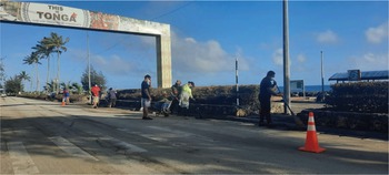
Caption: Still cleaning up Tonga. One of the first Facebook posts to come out of Tonga five days after the Hunga Tonga-Hunga Ha’apai eruption and the tsunami emphasizes the voluntary efforts of islanders to sweep the roads clean of volcanic ash. Although the ash fall and sulphuric air triggered concern among diasporic Tongans that people could be subjected to respiratory health issues, the general sentiment was one of admiration for the resilience of local islanders. (Photo by Marian Kofeola Kupu; “Nuku’alofa Foreshore,” Facebook, 20 January 2022)

Royal Palace
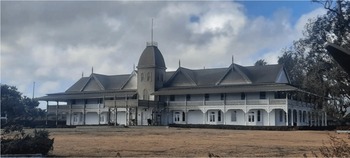
Caption: Pictures taken at Kolomotu’a and Sopu, which was severely damaged. The first batch of phone images captured the Nuku’alofa villages closest to the foreshore. The sight of the red roof of the royal palace blanketed in black ash stirred up sentiments from diasporic Tongans. Momentarily, this 19th-century colonial building symbolized more than a historic landmark: it was a marker of Tongan national identity, marked by the elements but still standing upright. (Photo by Broadcomfm Broadcasting; “Royal Palace,” Facebook, 21 January 2022)

Mango Island
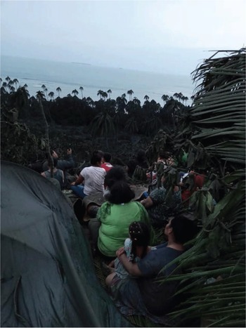
Caption: Mau kei mo’ui pe. Translated as “we are still alive,” the image and caption leads into the story of the people of Mango Island. Located 70 kilometres northeast of the Hunga Tonga-Hunga Ha’apai volcano, the homes and fishing boats of Mango’s 62 residents were destroyed by a wave of up to 15 metres; one resident, a 65-year-old man named Telai Tutuila, drowned. A young man, Piokalafi Faka’osi, took the image of the Mango Islanders early on the Sunday morning after the tsunami. They buried Telai Tutuila’s body on high ground by digging the six-foot-deep grave by hand, and were waiting for the Tongan Navy rescue boat to evacuate them 107 kilometers south to the main island of Tongatapu. (Photo by Piokalafi Faka’osi; “Mango Island,” Facebook, 23 January 2022)

Western Union
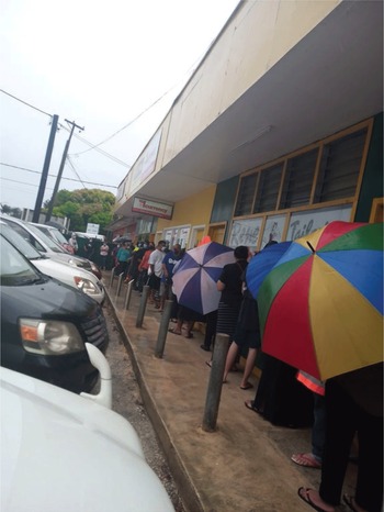
Caption: Ko e WU ena tu’u hoku apī hanga ki Kolisi Kuini Salote. Translated as “the line outside Western Union by Queen Salote College,” the image and caption underlines the significance of cash remittances sent to families in Tonga by their famili (close family) and kainga (extended family) living and working abroad. Cash was the preferred form of humanitarian assistance, giving people the freedom to choose how they wished to spend it. (Photo by Yvette Guttenbeil-Paea; “Western Union,” Facebook, 5 February 2022)

Diasporas and Islands
As writers of hybrid Pacific identities, we stress that when we reflect on the Tonga tsunami as an illustration of relational entanglements in the Anthropocene islands, our sensemaking and sensitivity are intricately woven to positionality and cultural context. There is little separation between us and Tongan audiences in the diaspora taking in and commenting on social media images and descriptions of the impact of the tsunami — just as there is little separation, if any, between climate change effects and natural disasters such as the tsunami.
Whether the volcanic eruption of Hunga Tonga-Hunga Ha’apai and the subsequent tsunami was climate-induced or not has never been a point of contention for Tongans in the islands and the diaspora. The social reality of everyday life in the Anthropocene islands is focused on living “with the more-than-human-forces” of extreme weather events and environmental changes. If scholars and artists collectively perceive sending cash, goods, and hope from the Pacific diaspora to their ancestral islands to be a solution to living with planetary transformation, then the social reality of how diasporas and islands become entangled will emerge.

 Open access