




The intent of this paper is to present the findings of what we have tentatively interpreted as an effigy mound in the Tehuacán Valley of Puebla, Mexico. This sort of effigy feature is quite unusual in Mesoamerica, and thus we felt it important to make colleagues aware of its existence, and of its possible use/function as an astronomical observatory.
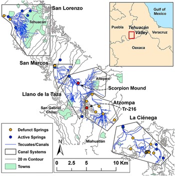
Woodbury and Neely (Reference Woodbury, Neely and Johnson1972) were the first to document in detail the spectacular and sophisticated prehistoric water management infrastructure of the Tehuacán Valley (Figure 1). Many of these features and systems were shown to appear in a remarkable state of preservation, size, number, and time-depth. There are approximately 100 square kilometers of canals in five major sections, extending along about 40 kilometers of the Tehuacán Valley floor (Figure 2). However, accelerating urban sprawl, changes in land use (commercial farming operations, poultry farms, highway construction, and the now defunct PROCEDE program to privatize communal and ejido lands) are endangering many of these water management systems and associated sites. Since the time when the presence and general nature of the systems were initially recorded in 1964, a great deal of destruction has taken place. Due to these circumstances, we have chosen to focus investigations on a few key sites and features, such as the Scorpion Mound Complex (SMC), before they are no longer available for study (Neely Reference Neely and Sanz2016; Neely and Castellón Huerta Reference Neely and Castellón Huerta2003, Reference Neely and Castellón Huerta2014; Neely et al. Reference Neely, Aiuvalasit and Clause2015; Neely et al. Reference Neely, Aiuvalasit and Winsborough2022). In addition, as new technology (e.g., GPS location technology, low-altitude drone photography and mapping) has become available, our studies have disclosed new and important information on the nature and functioning of these systems, their associated sites, and their roles in the economy and sociopolitical development of this region (e.g., Neely et al. Reference Neely, Aiuvalasit and Winsborough2022).
A rendered physical map of the Tehuacán Valley. The approximate boundary of the area containing “fossilized” canals as defined by survey is outlined in red. Image modified by Neely from MacNeish (Reference MacNeish, Nelken-Terner and de Johnson1967:figure 1).

Locations of the five “fossilized” canal segments of the Tehuacán Valley of Puebla (Neely et al. Reference Neely, Aiuvalasit and Winsborough2022:figure 5). The small red dot near the center of the Llano de la Taza system is the location of the Scorpion Mound Complex. The second red dot indicates the location of Site Tr-216.

Background
In North America the building of earthen mound structures has a history of over 2,500 years, from ca. 1400 b.c.e. to ca. c.e. 1300. Thousands of these mounds occur within a broad band extending from Michigan south into Louisiana (Apostol Reference Apostol1995:549; Birmingham and Rosebrough Reference Birmingham and Rosebrough2017; Christiansen Reference Christiansen, Peregrine and Ember2001). They appear as small plain conical mounds, large rectilinear platform structures as at Cahokia, and effigy mounds, representing mammal, reptile, bird, and other forms. Archaeologists have interpreted these constructions as serving religious, ceremonial, burial, and elite residential purposes (Birmingham and Rosebrough Reference Birmingham and Rosebrough2017; Rosebrough Reference Rosebrough2011). In Mesoamerica, effigy mounds are notably sparce.
The archaeological site with the scorpion-shaped effigy mound was found by survey as part of continuing investigations of prehistoric and colonial water management and irrigation systems in the Tehuacán Valley (Neely Reference Neely2002, 2016; Neely and Castellón Huerta Reference Neely and Castellón Huerta2014; Neely and Rincón Mautner Reference Neely and Rincón Mautner2004; Woodbury and Neely Reference Woodbury, Neely and Johnson1972). These surveys have documented the presence of a well-preserved large-scale canal-based irrigation system (Figure 1) divided into five distinct but partially overlapping segments, each with specific springs as water sources (Neely et al. Reference Neely, Aiuvalasit and Winsborough2022). The SMC is located near the center of the Llano de la Taza segment as well as the entire large five-segment canal system (Figure 2).
In contrast with North America, Mesoamerica has very few effigy mounds. These include the snake and bird effigy mounds at Casas Grandes (Paquimé) in the state of Chihuahua (Di Peso Reference Peso and Charles1974; Di Peso and Fenner Reference Peso, Charles and Fenner1974; Phillips and Bagwell Reference Phillips and Bagwell2009). These effigy mounds appear in the southwest portion of the site, and date to ca. 1200–1300 c.e. (based on the revised date for Unit 11, The House of the Serpent, by Phillips and Bagwell Reference Phillips and Bagwell2009). Several scholars working in various parts of Mesoamerica were contacted via email requesting their knowledge of existing Mesoamerican effigy mounds. A request for information was also published on ResearchGate (Neely Reference Neely, Aiuvalasit and Clause2015).
Phillip Weigand (personal communication 2010) responded with his knowledge of an effigy mound, representing a snake, in the Municipio de Tlacuichamona in the state of Sinaloa. However, Weigand stated that very little is known of that example, and, to his knowledge, the site has never been mapped or reported by archaeologists.
Robert Skiles (personal communication 2015) referred us to Adams (Reference Adams2005) who notes that the great aqueduct of the Mesoamerican complex of Kaminaljuyu (which was largely destroyed by the mid-twentieth-century expansion of Guatemala City) was known in early historic chronicles as “La Culebra” (The Snake) and likely began its existence as a vast effigy mound. For greater detail see Navarrete and Luján Muñoz (Reference Navarrete and Luján Muñoz1986).
In the Maya world, the turtle is a powerful cosmological symbol (Freidel et al. Reference Freidel, Schele and Parker1993:66–94). By Preclassic times the turtle was seen as a representation of Earth itself, and the Maya maize god (Frü) was born out of it. David Freidel (Reference Freidel, Eppich and Marken2024:274) argues that Structure 014-4 at El Perú-Waka’ (Petén, Guatemala) represents the cosmic turtle, and notes that a Late Preclassic mortuary structure at nearby site of El Achiotal was built as a turtle effigy (Freidel Reference Freidel, Eppich and Marken2024:273, see also Freidel et al. Reference Freidel, Eppich and Marken2024). Other quadripartite symbolism seems to be related to the cosmic turtle and appears at other sites (Collins Reference Collins2022).
Map of the Scorpion Mound Complex as well as its present geographic and cultural surroundings. Note the location of Site Tr-240. The locations of the loci shown correspond to the GPS coordinates obtained during the 2000 and 2004 field seasons.

Map of the Scorpion Mound Complex. The “X” represents the location of the badly damaged Mound 5. The “buried canal” is in fact a surface canal covered with thin slabs of travertine. The locations of the loci shown correspond to the GPS coordinates obtained during the 2000 and 2004 field seasons.

High-resolution digital elevation model (DEM) image of project area created via drone aerial photogrammetry showing elevation differences in color (places at higher elevations shown in yellow while areas at lower elevations appear in green). Note: SM = Scorpion Mound; B/SP = burial/storage pit; 1–11 = Mounds 1 to 11.

The environmental setting
The environmental characteristics of the Tehuacán Valley both imposed constraints and provided opportunities for resource exploitation by prehispanic peoples. The valley is about 2,000 square kilometers in area, and its length of about 100 kilometers slopes from northwest to southeast. From just north of Tehuacán City south to the area of the village of Coxcatlan, a straight-line distance of about 40 kilometers, is where the “fossilized” canals (Neely et al. Reference Neely, Aiuvalasit and Winsborough2022) associated with the SMC are located (Figure 1). The broad, slightly sloping, floor of the Llano de la Taza section (Figure 2) provided a good landscape for canal-irrigated agricultural development.
The Llano de la Taza is one of a series of gently sloping travertine surfaces separated by low but steep escarpments. The gradient of these topographic benches averages from about 8 to 10 meters per kilometer. The area is characterized by many natural springs, which were far more numerous and had higher yields in the past than at present. The llano has been classified as having a DdB’3 climate, characterized as being “arid, rainfall deficient in all seasons, temperate, with high evapotranspiration” (Thornthwaite Reference Thornthwaite1948). Smith (Reference Smith, Earl and Douglas1967:233, 240, 242) has evaluated this area as requiring some form of irrigation to support seasonal agriculture within the valley, and therefore it was an absolute necessity for agricultural intensification. Based on small areas of remnant vegetation and animal habitats, reconstructed from analyses of excavated animal remains, Flannery (Reference Flannery and Byers1967) reconstructs the original vegetation as primarily consisting of mesquite (Prosopis juliflora) and grassland flora, most likely accompanied by wild tree legumes and small shrubs like “coyotomate” (Castela tortuosa). Detailed environmental expositions are provided by Byers (Reference Byers and Douglas1967) and Yetman and Búrquez (Reference Yetman and Búrquez2023).
The site complex structures
The SMC is one of several sites situated on the nearly level Llano de la Taza and occupies an area of roughly 9 hectares. The site (Figures 3, 4, and 5) is of moderate size and complexity as compared with other contemporaneous sites (e.g., Tehuacan Viejo [Tr-1], El Cerro de Xantil [Tr-216], and Cutha [Tr-319]) in the valley [see MacNeish et al. Reference MacNeish, Peterson, Neely, MacNeish, Fowler, García Cook, Peterson, Nelken-Terner and Neely1972:486, 481, 400], Castellón Huerta Reference Huerta and Blas2006).
The site consists of 12 mounds, including the Scorpion Mound, and what may be a looted burial or storage pit, the details of which are presented in Table 1. Our initial impression was that the mounds characterizing this complex represented piles of cobble-sized angular fragments of travertine that had been collected during cultivation from the surrounding fields and discarded at their edges. However, a more careful inspection revealed that at some of the mounds the travertine cobbles covered earthen mounds. Furthermore, upon more careful inspection, eight of the 12 mounds comprising the complex were found to have incorporated room wall alignments (Figure 6).

The most significant difference noted immediately was the relative size of the mounded areas, and that the larger mounds (i.e., Mounds 1, 2–4) had either a courtyard or plaza whereas the smaller mounds (i.e., Mounds 6–11) did not. About 107 m south of the Scorpion Mound lies the isolated small subrectangular Mound 6, atop of which were wall alignments defining two joined rooms (Figure 6). The long axes of Mounds 1 and 11 are oriented east–west. Mounds 3, 4, and 10 are oriented north–south. Mound 2 is oriented northwest–southeast. Mound 5 was too disturbed to determine its orientation or original characteristics.
A shaft cut into the travertine substrate was found a few meters to the southeast of Mound 11 (Figures 4 and 5) and appears to be a looted pit of unknown use. It is irregularly circular in plan view, 80 cm in diameter and 55 cm deep. An irregularly circular slab of travertine about 1.3 m in diameter and 25 cm thick was found lying about 20 cm northwest of the shaft. No evidence of burning was evident. While this pit may have served as a cistern in the hand-watering of seedlings or small plants, its depth and proximity to flowing canals (Figure 4) would perhaps better indicate its function as a storage or burial pit.
A low-altitude drone photography and topographic mapping of the SMC and the associated “fossilized” canals was accomplished by Archaeo-Geophysical Associates, LLC, to provide better photographic evidence of the effigy mound and attributes of its association with the mound and plaza group and the “fossilized” canals. The drones used were a 3DRobotic X8 multirotor drone as well as a Skywalker fixed-wing drone. Both were equipped with high-resolution digital cameras that collected imagery for photogrammetric processing (e.g., Figure 5). This process also employed the expert use of other software packages.
The ceramic assemblage
Based on the large number of diagnostic surface ceramics found in association, the occupation of the SMC may be placed primarily in the Late/Epi-Classic and early Postclassic periods (ca. 600–1100 c.e.), with fewer late Postclassic ceramic types also present. All components of the site appeared to have similar ceramic assemblages, indicating that all parts of the complex were essentially contemporaneous.
Bowls, jars, and plate fragments were found, as were molcajetes (open tripod bowls with interior striations for grinding foodstuff) and fondo sellado (Castellón Huerta and Dumaine López Reference Huerta, Blas and López2000) types (open tripod-supported bowls with interior stamped designs—e.g., Figures 7, 8, and 9). Incensario (incense burner) and xantil (hollow figurine) fragments, believed to be involved in ritual, were also present (MacNeish et al. Reference MacNeish, Peterson and Flannery1970:186, 225). Most of the ceramics found appeared to have been made locally (MacNeish et al. Reference MacNeish, Peterson and Flannery1970:figure 153; Neff and Glascock, personal communication 2011). The phases and pottery types are as follows:
(1) Late Palo Blanco phase (Epi-Classic) types (El Riego Gray, El Riego Black, El Riego Orange, El Riego Plain, and El Riego Polished) (MacNeish et al. Reference MacNeish, Peterson and Flannery1970:164 ff.).
(2) Early Venta Salada phase (early Postclassic) types (El Riego Marble-Tempered, Coxcatlan Brushed, Coxcatlan Brushed Incised, Coxcatlan Gray, Coxcatlan Red, Coxcatlan Red-on-orange, and Teotitlan Incised) (MacNeish et al. Reference MacNeish, Peterson and Flannery1970:177 ff.).
(3) Early and Late Venta Salada phase (early to late Postclassic) types (Coxcatlan Coarse, Coxcatlan Red-on-cream, Coxcatlan Black-on-orange, and Coxcatlan Polychrome) (MacNeish et al. Reference MacNeish, Peterson and Flannery1970:177 ff., 211 ff.).
Field drawings of Mounds 9 and 6 as examples of mounds with visible wall alignments.

Photos of the molcajete offering. Left photo is as offering was found; right photo shows cover bowl removed.

A sample of ceramics collected from the field immediately south of the Scorpion Mound.

A rendering of a to-scale sketch of the Scorpion Mound generated during our 2000 field season in the Tehuacán Valley. North is magnetic.

However, some of the sherds recovered, especially from the Scorpion Mound area, were types apparently traded into the Tehuacán Valley (Fine Orange, Incised Fine Orange, Ñuiñe (?) Incised Brown, early Postclassic Aquiahuac phase Cholula “Marta” bi-chrome and “Estela” polychrome types, and a few late Postclassic Mártir phase Cholula “Nila” and “Catalina” polychrome types (Lind et al. Reference Lind, Barrentos, Turner, Casky, Geoffrey McCafferty and Orea1990; Reference Lind, Nicholson and Keber1994:81; McCafferty Reference McCafferty1996), as well as Texcoco Black-on-red, Tenayuca Black-on-orange, and Mixtec Black-and-red-on-orange. Interestingly, the forms and polychrome decoration of several sherds present at this site resembled types found in the Mixteca (McCafferty Reference McCafferty, Nicholson and Keber1994), but the decorative elements seem less carefully painted than the Pilitas style polychromes that have been described for the Mixteca (Caso et al. Reference Caso, Bernal and Acosta1967).
Late Classic pottery at Cacaxtla, about 150 kilometers to the northwest, includes ceramics from Tehuacán, Oaxaca, and the Gulf Coast, suggesting that trade or commercial ties existed between those four geographic regions; and that Cholula, as a major center for pochteca (merchant) trade may well have been the major distribution point (Brittenhausen and Uriarte Reference Brittenhausen and Teresa Uriarte2015; McCafferty Reference McCafferty2001; Uruñuela and Plunket Nagoda Reference Uruñuela, Ladrón de Guevara, Nagoda, Stanton, Taube, Coltman and Marengo Camacho2023).
The Scorpion Mound
Mesoamerican religions were polytheistic and included a complex pantheon of deities that were tied to natural and human elements such as the sun, water, and agriculture. The Earth was the center of all things, fixed and immovable. The stars, moons, sun, and planets were deities (Miller and Taube Reference Miller and A.Taube1993). Nature was experienced in all its complexity not as an entity out there, but rather as deeply connected with superhuman powers and beings, manifesting themselves in countless aspects of the surrounding world and a sacred landscape. The most important shared characteristics of Mesoamerican cultures were their relationships with the gods and their environment. The typical Mesoamerican person lived in a highly communal hunter-gatherer or agrarian group living in a social setting in a diverse ecological world. Religions were environmentally based, and humankind was inextricably linked with the natural world. Each culture had its own deities, though some did overlap between groups.
We have interpreted the elongated feature at the apparent northwest corner of the site as a low effigy mound in the shape of a scorpion (Figures 4, 5). The scorpion (Tlāhuizcalpantēcuhtli) was a prominent celestial deity for the peoples of ancient Mesoamerica and a principal member of the pantheon of gods within the Aztec religion. In the complex mythology of the Mesoamericans, it represented Venus the Morning Star.
Venus was also related to, and at times represented by, two other deities: Tlaloc, the god of rain and water, and Quetzalcoatl, the Feathered Serpent and patron deity of the Mexica/Aztec peoples (Brittenhausen and Uriarte Reference Brittenhausen and Teresa Uriarte2015; Robelo Reference Robelo1905:345–436). Because of its shape, its relationship with water and rain, and its central location, the Scorpion Mound was recognized as a potentially important feature within the context of the large complex of canal-irrigated fields, occupying a conservatively estimated 100 square kilometers (10,000 hectares). This is currently the largest and best-preserved prehistoric canal-irrigated field system in Mesoamerica. This system represents a continuity of use from ca. 2000 b.c.e. to the present day (Neely et al. Reference Neely, Aiuvalasit and Winsborough2022).
With its body, head, and claws (long axis) oriented toward the east-northeast, the Scorpion Mound is constructed of unmodified angular cobble-size travertine chunks with evidence of an earthen mound beneath. It has an undulating surface with convex transverse and longitudinal cross sections. There is no evidence of a leveled area atop where people could comfortably stand, or a structure could be placed. The mound has maximum paced dimensions of 62.5 m in length, 13.2 m in width across the body, and 22.1 m in width across the front claws (pedipalps) and is about 80 cm in maximum height (Figure 9). Its tail tapers, as a sloping mound of similar travertine cobbles, transitioning into a slightly elevated mounded section, comprised of a few partially buried cobbles, that curves southward and terminates in a pile of ceramic sherds 3.75 m in diameter and 12 cm in height (referred to below as the “stinger”). A somewhat disturbed roughly circular pile of unmodified angular travertine cobbles and ceramics, about 7 meters in diameter and 20 cm high, was found about 2 meters west of the tail. A piece of travertine cut in the shape of a stylized pincer (chela) was located about a meter east of each of the arms (pedipalps) of the effigy. Another pincer-shaped slab of travertine was found about 11 meters east of the south arm. That cut slab is smaller and is broken. It may represent a failed attempt to produce a pincer for the mound.
The Scorpion Mound is not surrounded by other mounds. The closest mound, number 6 (Figures 4 and 5), lies 107 m to the south, with the 10 remaining mounds of the complex located to the southeast at least 150 m away. These 10 mounds form two roughly diagonal alignments of five mounds each that have a southwest to northeast orientation. The larger mounds with courtyards or plazas are closest to the Scorpion Mound, while the smaller mounds without courtyards or plazas are aligned a bit further to the southeast. This mound complex lies just north of two ancient primary “fossilized” canals (Figure 5). A large secondary canal, now defunct, branched from the westernmost of these two canals. It flowed south to the western fields of the large mountain-top town site El Cerro de Xantil (Tr-216, Figure 2), a site that was San Gabriel Chilac’s probable ancient predecessor (MacNeish et al. Reference MacNeish, Peterson, Neely, MacNeish, Fowler, García Cook, Peterson, Nelken-Terner and Neely1972:481–482, figure 195). The two original primary canals continued east to the municipality of San Juan Altepexi and its associated fields. The canals coursing east are unusual in that they are covered with large thin slabs of travertine for part of their length immediately south of the SMC.
The nature of the site’s mound features must be considered. The most likely sort of non-intentional human agency that could have produced this scorpion-shaped feature, and other rock mounds on the llano, is field clearing. That activity would generally result in the discarding of the travertine fragments impeding cultivation onto vacant areas adjacent to the fields. As our INAH permit did not allow us to conduct excavations, we had to depend on less concrete evidence observed during survey to make our determinations.
While the visible shape of the mound may be interpreted as a scorpion, we observed several other forms of evidence that supported our interpretation that the Scorpion Mound represents an intentional prehistoric human construction with important cultural meanings. (1) An earthen mound lies beneath the cobbles of travertine at the Scorpion Mound and some of its associated mounds. (2) The mound construction (i.e., the construction materials, their size, and the manner of placement) is like mound construction seen at many other nearby sites, such as the large diffuse valley town site Tr-240 (Figure 3) (MacNeish et al. Reference MacNeish, Peterson, Neely, MacNeish, Fowler, García Cook, Peterson, Nelken-Terner and Neely1972:432). (3) Wall alignments were discernable among the travertine cobbles at some mounds in the complex (Figure 6) and elsewhere on the llano. (4) The central location of the complex among the “fossilized” canals (Figure 2), suggests its role as an important central place. (5) The majority of diagnostic incised and polychrome ceramics from the site were present on and around the effigy mound. (6) Following Šprajc’s (Reference Šprajc2018:215) observation, the ceramic dating of the Scorpion Mound correlates positively with the Classic and Postclassic periods when the dated structures with Venus connections were built. (7) A flat vessel support was present containing the glyph “One Reed” (Ce Acatl), connoting Quetzalcoatl as Venus. (8) Incensario (incense burner) and xantil (hollow figurine) fragments were present which we interpret as being involved in ritual (MacNeish et al. Reference MacNeish, Peterson and Flannery1970:186, 225). (8) A large obsidian laurel-leaf-shaped fine biface segment was present; these are thought to be ceremonial in nature (MacNeish et al. Reference MacNeish, Nelken-Terner and de Johnson1967:91). (9) V-shaped cut stone “pincers” are present at the end of the scorpion’s two claws. (10) The association of the Cactus stellatus bordering the north side of the mound frequently indicates human placement (Casas et al. Reference Casas, Pickersgill, Caballero and Valiente-Banuet1997). (11) The hypothesis of the Scorpion Mound being a human-constructed feature was further supported by the presence of a “killed” Tan/Brown-ware tripod bowl covering a Tan/Brown-ware tripod molcajete (Figure 9), containing a modern offering of tobacco and chilies. Both vessels are similar to the utility wares found in the present-day local markets. These vessels were found atop the mound near what would be the head of the scorpion, suggesting the ritual use of the mound in the historic/modern period. (12) A scorpion-shaped mound was likely important as a symbolic ceremonial feature within the central context of the large system of canal-irrigated fields.
While the list of supporting observations varied, other mounds on the Llano de la Taza also presented generally similar evidence of human construction.
An outline of the Scorpion Mound is shown superimposed on a drone-generated aerial photo of the feature. The prominent red line pointing northeast shows the summer sunrise azimuth (65°), viewed from the “stinger,” at the tip of the northern claw. An additional red line, on the left side of the figure, shows the sunset azimuth on the summer solstice (295°). On the evening of the winter solstice, as the green line indicates, the setting sun could be sighted by standing at the tip of the northern claw and sighting back over the feature identified as the “stinger,” with the sunset azimuth at 245°. The sunrise azimuth on the day of the winter solstice (114°) is also shown in blue.

The practice of leaving votives or special offerings at archaeological sites or sacred places is still widely practiced in Mesoamerica (Frühsorge Reference Frühsorge2015), and indeed worldwide (Leskovar and Karl Reference Leskovar and Karl2018). In highland Guatemala, Barbara Tedlock (Reference Tedlock1992) records a Maya priest noting that the sites and the goods left at them inscribe a sort of community history and are often associated with specific lineages. Šprajc (Reference Šprajc1993b:S45) also notes that, “ethnographic evidence … suggests that the beliefs and rites involved in the Venus-rain-maize complex … persist in present-day rural communities.”
the possible use/function of the scorpion mound as an astronomical observatory
As noted, the astronomical observations of the ancient inhabitants of Mexico, intertwined with religious ideas and practices, held an important place in Mesoamerican worldviews and, therefore, in cosmologically based ideologies. In this instance, we hypothesize it was the timing of agricultural activities, such as planting and harvesting, that was being planned according to celestial observations. The aspect of certain constellations (e.g. Venus) was used to predict seasonal changes and weather patterns. This allowed Mesoamerican societies to optimize their food production and ensure the sustainability of their communities.
The following is more speculative than the previous section on the archaeology of the Scorpion Mound. The mound’s general orientation toward the east-northeast suggested to us that it may have been aligned with sunrise on the summer solstice. This observation was made after the fieldwork took place, so it was not part of the research design, nor were we able collect data on this specific question. Nevertheless, the field research and mapping suggest that the use/function of the mound for solstice observations is a viable hypothesis and should be considered in future research. Toward that end, we explore it in the following discussion.
Figure 10 shows the alignment of the Scorpion Mound and plots the azimuths of the summer and winter solstices. We calculated the sunrise azimuth on the summer solstice for the location of the mound to be 65° east of north, which is where the sun would come up on the summer solstice on June 21. That is based on the location of the mound (latitude 18.371810, longitude −97.328519, altitude 1,260 m) and determined using the solar calculator devised by the National Oceanic and Atmospheric Administration (2023). This includes a slight (less than 0.5°) correction for the Earth’s “wobble” caused by the precession of the equinoxes. Estimates were made for the years 600 and 1000 c.e.. Because we did not take sightings of the surrounding mountains, we cannot judge whether there are peaks or other landmarks that might have been sighting points, and we have estimated the sunrise azimuth assuming a flat horizon, which is not the case in the Tehuacán Valley. We can correct for atmospheric refraction, parallax, altitude, and pressure (Rodegerdts and Bauer Reference Rodegerdts and Bauer2013) but the solar azimuths presented here are nevertheless estimates, requiring more precise field testing. With these provisos, we estimate that on the morning of the summer solstice, if a person sighted from the “stinger” (the circular ceramic cluster at the presumed end of the scorpion’s tail), the sun would rise above the tip of the northern (left) claw (see the red line on Figure 10).
For the winter solstice the sun would have risen at 114.5° east of north. We also checked the azimuths for the evening sunset at the summer and winter solstices (winter solstice, 245°; summer solstice, 295°). We found that at sunset on the winter solstice one could get a sighting from the tip of the left (north) claw back across the “stinger” at the end of the tail and to the setting sun beyond (see the blue line on Figure 11). Based on these estimates, the mound would allow its users to identify the dates of both the summer and winter solstices, common alignments for Mesoamerican architecture (Šprajc Reference Šprajc2018:221–224, Reference Šprajc2023).
Images on the south and north piers in Substructure III of the Cacaxtla Palace (after Šprajc Reference Šprajc1993b:figure 3). Note five-lobed Venus motif at the waist of each figure and the scorpion tail on the male image to the right.

Based on the evidence, we suggest that these alignments are intentional. This mound and its associated features must be further investigated through excavation and additional field study by an archaeoastronomer. It would be particularly interesting to test for sighting markers, perhaps postholes or other objects, at both the “stinger” location and the tip of the north claw. That said, we acknowledge the potential problems associated with trying to make these astronomical interpretations after fieldwork was finished and reiterate the provisional nature of the solstice-sighting hypothesis.
Having the means to mark certain solar phenomena is common in Mesoamerica:
That so many buildings were aligned with the Sun undoubtedly refiects practical utility of this celestial body. To keep track of the seasons, the most elementary references were the solstices, marked by easily perceivable extremes of the Sun’s trajectory along the horizon, and the quarter-days. (Šprajc Reference Šprajc2018:221).
For Mesoamerican farmers the summer solstice was, and remains today, an important ceremonial date and date for action, because it connotes the beginning of the rainy and planting season. Fray Diego Durán (Reference Durán1880:305), writing in the sixteenth century, noted the importance that the native calendar had for communities: “to know the days in which they had to prepare, sow, and harvest, the corn field.” He also noted it as “a very remarkable fact” that the Mexican farmers strictly followed the calendrically based instruction of the elders to plant and harvest their fields and would not start their farming activities without their approval. Although Diego Durán was referring to the late Aztec period, we feel the astronomical associations with the agricultural calendar are relevant for the present study, especially in the semi-arid Tehuacán Valley, where even irrigated horticulture is a challenging enterprise.
For the days leading up to the solstice, the sun would rise between the two claws, and thereby signal the approach of the rainy season so the local farmers could prepare their fields for planting. It is conceivable that when the sun reached the north claw and began its regression back toward the southern claw, the time for post-planting chores could be determined. This movement of the rising sun across the breadth of the two claws is also important because the azimuth/declination of the sunrise on the solstice is very close to that of the days before and after it, so the observer would have to be observing precisely to mark the solstice day exactly.
The location of the SMC on the Llano de la Taza (Figure 2) is very near the center of an extensive and long-cultivated area, at a major bifurcation of the fossilized primary canals from the Cozahuatl (yellow water) spring (Neely et al. Reference Neely, Aiuvalasit and Winsborough2022). Its location suggests that it may have been related to administrative functions involving the distribution of canal waters from the Llano de la Taza to the south and east. Thus, this site may have functioned as an agricultural water-oriented ritual center.
conclusions and suggestions for future work
The Scorpion Mound data and interpretations presented herein are based solely on survey findings. This paper is intended as an initial presentation about the SMC, hopefully to be followed by excavations and a more detailed field study of the site. As discussed above, the realistic form of the mound along with the 12 observations about it have led us to the interpretation that it represents a human-made feature of intentional outlines and orientation. The possible use of the mound for marking the summer and winter solstices, while still requiring further research to confirm, suggests one possible use and function for its existence.
Earlier in this paper we mentioned that ceramics from Tehuacán have been found at Cacaxtla. In addition, there may have been a more meaningful cultural relationship beyond trade between these two sites. During the tempestuous changing times of the Epi-Classic Period (García Cook Reference García Cook and Chadwick2013), the presence of the figures with Venus and scorpion motifs (Figure 11) on the south and north piers in Substructure III of the Cacaxtla Palace (Robertson Reference Robertson and Elizabeth1985; Šprajc Reference Šprajc1993a and Reference Šprajc1993b):S28–29) and the unusual scorpion effigy mound in Tehuacán may both reflect the formation of a new political and religious ideology linked to the Olmeca–Xicalanca presence at the site of Cacaxtla (Plunket and Uruñuela Reference Plunket and Uruñuela2005:103). The distribution of the Scorpion Venus cult has been studied by Carlson (Reference Carlson1991, Reference Carlson, Clive and Saunders1993), and he has determined that it was not only prevalent in the Maya, Tlascala, and Cholula areas but also extended throughout Mesoamerica (Carlson and Cherry Reference Carlson and Cherry1996:156; see also Milbrath Reference Milbrath1999:211). It is conceivable that future excavations at the SMC would reveal information regarding that relationship and provide a more complete picture of the Epi-Classic Period and the proposed Maya influences on the Mexican altiplano cultures (Robertson Reference Robertson and Elizabeth1985).
The Scorpion Mound may have provided a means for the area’s inhabitants to be able to determine the times of the summer and winter solstices, events which we know to be very important in their annual agricultural cycle. Thus, the SMC may represent the interface of ritual and water management technology, as suggested by Marcus (Reference Marcus, Marcus and Stanish2006:248), and lends insight into the Tehuacános’ relationship with water. With further evidence, this physical manifestation of a ritual practice could be seen as part of the builders’ supplication to supernatural powers for rain and a good crop. It may also have served as an element of built ritual technology involving the solstices.
The SMC presents a comparatively small installation at a relatively small site, rather than the sort of large, carefully constructed and astronomically aligned structures found at regionally important sites such as at Cacaxtla, Xochicalco, Monte Alban, Chichén Itza, and other large elite-managed Mesoamerican sites. However, with the conquest the privileged astronomical knowledge of the elite ruling classes was lost, and as Šprajc (Reference Šprajc1993b:S45) has noted: “ethnographic evidence …. suggests that the beliefs and rites involved in the Venus-rain-maize complex could not have been an exclusive domain of the elite, since they persist in present-day rural communities.” This may shed light on the integration of calendrical ritual with the surrounding large complex system of fields and irrigation canals, providing insight into the use of sophisticated ritual at the more egalitarian local/community level of sociopolitical complexity in Mesoamerica. It is likely that the prehistoric campesinos lived as much a life of independence and self-determination from state control as do their modern counterparts (Enge and Whiteford Reference Enge and Whiteford1989:181 ff.).
It is hoped that future research at the complex will reveal information regarding the ritual use of the Scorpion Mound, and its relationship to other sites. As next steps, we would suggest excavations at the mound site to explore the exact limits and construction technology of the Scorpion Mound, along with its possible phases of construction and maintenance. The construction chronology should be investigated, obtaining the most precise dating possible. Also particularly significant would be the presence of structures, posts, or other features associated with the tail, body, and pincers. In addition, future research should include the comparative ceramic chronology of the Scorpion Mound and the nearby structures and features, including the irrigation features. Post-abandonment taphonomic processes should be explored as well as any post-use modifications by agricultural or earth-moving activities. The ongoing use of the mound for ritual acts should be examined stratigraphically, particularly at the features at the tip of the tail.
A final thought
Perhaps the statement from the Golden Bough should be kept in mind when considering new archaeological observations and interpretations: “The advance of knowledge is an infinite progression towards a goal that ever recedes.” (Frazer Reference Frazer1890:vol. 3, 460). Aveni (Reference Aveni1992:3–4) also calls for: “scholars and students to seek common ground for discovery to open ourselves to what the ancient observers were expressing.”
Spanish abstract for the paper “The Scorpion Mound Complex: An Effigy Mound Site with Possible Functional/Ceremonial Significance in the Tehuacán Valley of Puebla, Mexico.” by James Neely et al.
Mientras realizaban un estudio arqueológico para documentar los grandes sistemas de canales prehistóricos en la parte central del Valle de Tehuacán, los investigadores registraron un complejo de montículos y plazas que incluye lo que parece ser un montículo con forma de efigie de escorpión. Grandes cantidades de cerámica, incluyendo superficies decoradas y policromadas, indican una ocupación del Clásico Tardío y Posclásico. El sitio se interpreta como parte de un sistema agrícola intensivo, tal como aparece en el contexto de ubicación de desarrollo agrícola intensivo y riego por canales. Una reevaluación posterior al trabajo de campo apunta a la construcción humana de esta característica inusual. Se plantea la hipótesis de que forma parte de un complejo cívico/ceremonial local, con el posible uso de la observación de los solsticios de verano e invierno. Si es así, proporciona una idea de la integración del ritual calendárico con el complejo sistema circundante de campos y canales de riego.
Acknowledgements
Our thanks go to the Instituto Nacional de Antropología e Historia de México for granting permits to conduct fieldwork. Field research was funded by the National Science Foundation (Grant #9986718), the National Geographic Society, the Wenner-Gren Foundation, the H. John Heinz III Charitable Fund Grant Program for Latin American Archaeology, Robert Mellon Foundation Faculty Research Grant, and Archaeological Research Inc. The William J. Bryant 1925 Professorship, Dartmouth College, provided funds to conduct NAA analyses on 20 Coxcatlan Brushed Incised sherds from the Scorpion Mound Complex.
We extend our appreciation to all the following individuals who have contributed significantly to this study. The farmers of the Llano and interested citizens of Tehuacán, Michael Aiuvalasit, Enrique Rodriguez-Alegria, Andrew Balkansky, Frances Berdan, John Cotter, George Cowgill, Destiny Crider, Peter Dana, William Doolittle, Marco Fragoso F., Michael Glascock, Michael Hironymous, Kenneth Hirth, Michael Lind, Joyce Marcus, Hector Neff, Deborah Nichols, Michael O’Brien, Anuar Patjane Floriuk, Francisca Ramirez Sorensen, Carlos Rincón Mautner, Bob Skiles, Michael Smith, Javier Urcid, and Phil Weigand. We are also indebted to Chester Walker and Mark Willis of Archaeo-Geophysical Associates, LLC for conducting the 2015 drone imagery of the complex that contributed to the documentation and mapping of this site.



 Open access

