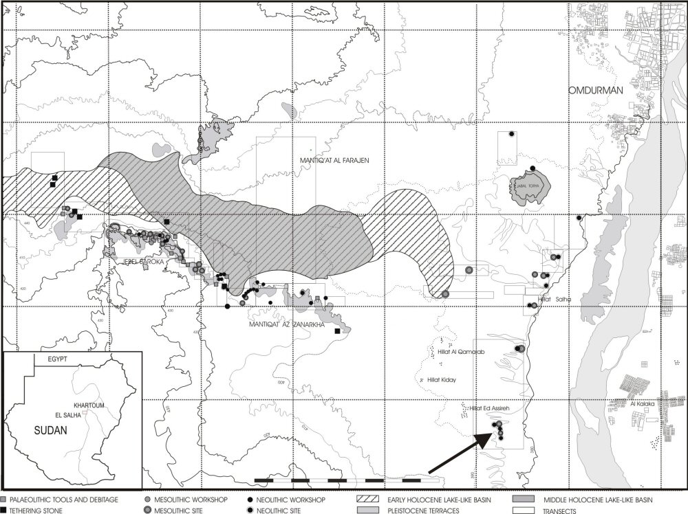
The El Salha Archaeological Project has been the subject of archaeological and geo-morphological reconnaissance and excavation in Central Sudan by the Is.I.A.O. (Istituto Italiano per l'Africa e l'Oriente) since the autumn of 2000. The name given to the project comes from the El Salha village which lies along the western bank of the White Nile at about 15km south of Omdurman (Figure 1). The two main goals of the project are the archaeological exploration of one the core areas of the Mesolithic and Neolithic cultures along the Nile Valley, scarcely known to date (Reference ArkellArkell 1949; Reference MarshallMarshall & Adam 1953), and the emergency investigation of several large archaeological sites located along the Nile bank and in the interior in danger of destruction because of the rapid urban growth of the villages located south of Omdurman. We have now located 160 archaeological sites (settlements and graveyards) ranging from the Lower Palaeolithic to the Early Islamic period (Reference UsaiUsai & Salvatori 2002). Of particular interest are the many Mesolithic and Neolithic sites, which are often larger than 10ha in size, located both along the Nile and in the interior along the edges of an Early and Middle Holocene lagoon or lake-like basin. This wide lagoon reached, at its maximum extension, in the Early Holocene, the slopes of the Gebel Baroka, 30km to the west the Nile (Reference CremaschiCremaschi et al. 2006).
Location map.

During the 2002 season the team located an elongated mound, labelled 16-D-5 following the taxonomy proposed by Reference HinkelF. Hinkel (1977: 24-6) on the western bank of the White Nile about 25km south of Omdurman (36 P 0436329/ UTM 1708138). Pot-sherds collected on the surface of the mound were partly indicative of the Khartoum Mesolithic (Reference ArkellArkell 1949) and partly the later Shaheinab Neolithic phase (Reference ArkellArkell 1953) of the Central Sudan sequence. In the winter of 2004, a test trench (5 x 5m) was excavated on the north-western slope of the 16-D-5 mound to verify the state of preservation of the anthropic layers which are often disturbed and subsequently mixed up by the succeeding construction of Meroitic and Post-Meroitic burial tumuli (Reference CanevaCaneva 1995: 78; Reference UsaiUsai & Salvatori 2006). This operation revealed that Neolithic and Mesolithic deposits had been disturbed to a depth of c. 60cm, almost certainly due to the building of a large Post-Meroitic tumulus, and at a depth of c. 60cm a Post-Meroitic pit grave appeared. The pit had been filled with a large amount of broken grinding stones under which was a Post-Meroitic Jar. The deceased was lying crouched on the right side, south-north oriented, in front of a beer jar covered by an overturned bowl.
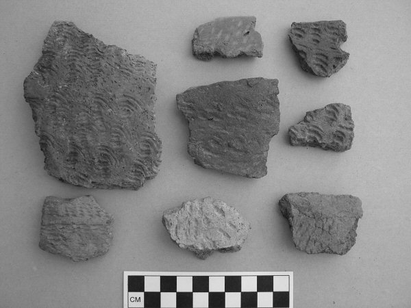
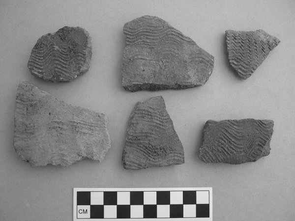
At about 40cm beneath the level of the Post-Meroitic pit-grave, a more compact and apparently undisturbed layer appeared. The only disturbances we noticed were some rodent burrows, quite frequent in the archaeological deposits of other tested sites. At this point the archaeological deposit appeared clearly stratified with evidence of features in the shape of round whitish spots. Below the disturbed upper layer the archaeological material was homogenous and all of it belonged to the Khartoum Mesolithic horizon. This layer sealed an extensive deposit 5-7cm thick containing abundant fragments of Pila wernei and/or Lanistes carinatus fresh water gastropods. A similar situation was evidenced at Shabona, another Khartoum Mesolithic site located many years ago farther to the south (Reference ClarkClark 1989: 406). A concentration of these gastropods was found inside a pit (Stratigraphic Unit 6). The assemblage recovered from the pit included, beside the gastropods, faunal and fish remains, a sandstone grindstone with well preserved traces of red and yellow ochre powder on one face, two fragmentary sandstone rings, two granite grinders and several Mesolithic pot-sherds with the typical wavy line decoration were found (Figure 2a-b). Under the grindstone and mixed with the other worked stones a charcoal sample was collected for radiocarbon determination. This gave a date consistent with the associated pottery (Beta-201728: 7980±40 bp; 1 σ 7050-6820 cal BC) further supported by a determination from a fireplace whose displaced materials were covering the above mentioned pit (Beta-213892: 7870 ±40 bp; 1 σ 6820-6640 cal BC).
Pottery sherds from pit US 6.

Wavy Line pottery sherds from pit US 6.

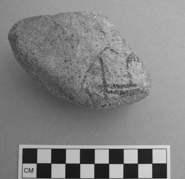
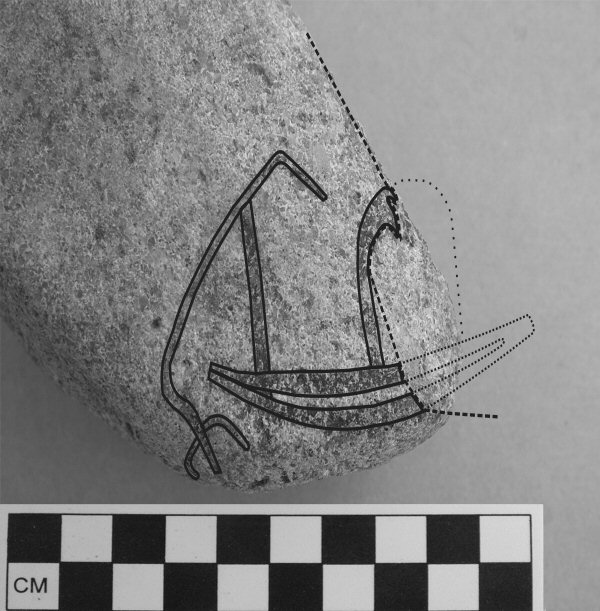
Included in this assemblage was a granite pebble which preserved, on one face, a black painted sketch, recognisable as part of a boat (Figure 3a-b). The painted lines and traces are a little bit raising from the pebble surface and easy to be recognised on the original object. Other black or dark grey marks on the pebble's surface are due to dark grains of the granite stone. The picture represents the back half of the boat, including part of the hull, a steering system and what seems to be a cabin placed more or less at the centre of the upper hull. The steering system seems to be of a composite type: a tiller, placed at more than 45° with a long pole ending in a ovoid blade, all fixed to the top of a vertical pole. Unfortunately the pebble is broken and the loss prevents us from a complete knowledge of the cabin and prow shape. There was no trace of black paint on the fracture, so that the image must have continued on the missing part. In spite of this gap, the similarity of this representation with later examples dating to the fourth millennium BC, like the Badarian boats painted on dwelling walls and pottery jars, is striking (Reference AksamitAksamit 1981).
Granite pebble with painted motif.

Interpretation of the painted motif.

The 16-D-5 boat can also be compared with boats represented on well known rock engravings from different places in Sudanese Nubia (Reference ReschResch 1967; Červiček 1974; 1986; Reference HellströmHellström 1970) and Egypt (Reference HuygeHuyge 1984; Reference Huyge2002; Reference Almagro BaschAlmagro Basch & Almagro Gorbea 1968; Reference AksamitAksamit 1981; Reference WinklerWinkler 1938). Some of these are currently dated to the Predynastic period (Reference HuygeHuyge 2002) through comparison with boats portrayed on Gerzean and Naqadian pottery vessels, wall paintings and art objects (Reference AksamitAksamit 1981). In particular the image of a steering gear fixed to a vertical pole inserted in the stern upper hull can be found on rock engravings from the Abka region in Sudanese Nubia (Reference HellströmHellström 1970: Corpus V63 359:30; V65 359:26; V21 169j20) and from Akkad, south of the third Cataract on the left bank of the Nile in the Northern Dongola Reach (Reference SmithSmith 2003: Figure 7). The blade strongly resembled those of the boat of El Khab (Reference HuygeHuyge 2002). This kind of composite helm was still in use on Egyptian ships of the New Empire. The dome-like cabin on the upper hull is also a well known feature on boat representations dating to the Gerzean and Predynastic periods in Egypt and Nubia (Reference HellströmHellström 1970; Červičcek 1974; Reference AksamitAksamit 1981). We ruled out the hypothesis of a frond because the frond is generally oriented toward the stern and usually placed at prow in later (mainly Naqada IIb) representations.
The discovery of a boat representation on a pebble dating to the early seventh millennium BC, according to the associated pottery and the contextual radiometric determinations, is worth some comment. This chronological attribution may re-open the discussion about the dating of some rock engravings found along the Nile and generically attributed to a period before or around 4000 BC, and on the use of developed boat types for navigation and fishing along the Nile. This discovery anticipates the accepted beginning of navigation along the Nile by about 3000 years. Moreover, it provides a strong confirmation of the hypothesis for the Mesolithic use of boats advanced by Reference Van NeerW. Van Neer (1989: 54; 1994: 20-1) and Reference PetersPeters (1991: 38-9; Reference Peters1993: 417), on the basis of the study of the ichthyo-faunal remains from Mesolithic sites in Central Sudan and the lower Atbara . Peters, indeed, is explicit in suggesting the use of boats in fishing for the large adult specimens of Synodontis, Bagrus and Lates, all 'open waters species', well represented in the faunal samples of Mesolithic sites of the area, while ruling out the possibility of their having been caught in seasonal flood pools.
The painted pebble from 16-D-5 site offers, at the moment, the oldest evidence for Nile boats possibly used in fishing activities in open waters and, considering the well developed type of vessel portrayed, also for more extensive navigation purposes along the river.
Acknowledgements
We wish to thank Cheryl Ward for her stimulating criticisms and insightful comments.