

Introduction
In 1983, a joint radio echo-sounding programme was undertaken in Svalbard by the Scott Polar Research Institute (SPRI) and the Norsk Polarinstitutt. About 4900 km of flight track were covered in Spitsbergen and Nordaustlandet (Reference Drewry and Liestøl.Drewry and Liestel, 1985; Reference DowdeswellDowdeswell, unpublished). The flight lines are indicated in Figure 1. The radar data were recorded digitally (Reference Gorman and CooperGorman and Cooper, 1987) at an interval equivalent to about 120 m along track. The substantial size of the resulting data set and the use of digital recording techniques have allowed a detailed statistical analysis of the echo strength.

Fig. 1. Map of radio echo-sounding flight lines in 1983. Glaciers sounded in Spitsbergen were: Sveabreen (1), Kongsvegan (2), Kronebreen (3), Abrahamsenbreen (4), Vonbreen (5), Holtedahlfonna (6), Fjortende Julibreen (7), Lilliehöökbreen (8), Raudfjordbreen (9), ldabreen (10), Monacobreen (11), Isachsenfonna (12), Holmstrombreen (13), Sefströmbreen (14), Uvérsbreen (15), Murraybreen (16), Aavatsmarkbreen (17), Dahlbreen (18), Eidembreen (19), Nansenbreen (20), Borebreen (21), Wahlenbergbreen (22), Hochsteterbreen (23), Akademikerbreen (24), Hinlopenbreen (25), Kvitbreen (26), Russebreen (27), Oxfordbreen (28), Lomonosovfonna (29), Tunabreen (30), Fimbulisen (31), Petermannbreen (32), Negribreen (33), Olav V ice cap (34), Valhallfonna (35), Dunérbreen (36), Åsgårdfonna (37), Veteranen (38), Chydeniusbreen (39), Tommelbreen (40), Balderfonna (41), Formidablebreen (42), Mittag-Lefflerbreen (43), Nordenskiöldbreen (44).
Besides the routine application of radio echo-sounding data to determine ice thicknesses Reference Dowdeswell, Drewry, Liestøl and Orheim(Dowdeswell and others, 1984a, Reference Dowdeswell, Drewry, Liestøl and Orheimb), quantitative investigations have been made of the reflecting properties of both the ice/bed interface and internal layers. It is the aim here to deduce, from these data, characteristics of the reflecting horizon. Large variations in power-reflection coefficient and dielectric absorption were observed, and from these and other relevant data (such as temperature measurements) inferences about the ice/bed environment and bulk thermal properties of the ice have ' been made. The results incorporate data from 34 ice masses in Spitsbergen and an extensive network from the largest ice cap in the archipelago — Austfonna — in Nordaustlandet.
Svalbard glaciers vary considerably in their thermal regime and as a consequence their bed environment is also variable. For example, Austre Braggerbreen (Fig. 1; lat. 78°50′N., long. 11°30′ E.), and Foxfonna (Fig. 1; lat. 78°N., long. 16°E.) are both believed to be frozen to their beds Reference Listøl(Liestel, 1974, Reference Listøl1984), whereas radio echo-sounding data suggest that many of the glaciers sounded in the north of Spitsbergen have a considerable part of their thickness (100–200 m) at or close to the melting point (Reference BamberBamber, 1987). Yet the climate is observed to get colder moving north and east across the archipelago (Reference SteffensonSteffenson, 1982). Generalizations about a geographical control of thermal regime are not possible and other factors are often more important (as in the examples quoted, where the thinness of the glaciers is of greatest relevance). 10 m temperatures may also be misleading with respect to the bulk of the ice as a consequence of the percolation and refreezing of melt water in the firn during the summer (Reference MullerMüller, 1963). The variability of this contribution to the heat budget could explain the markedly different values for the 10 m temperatures near the summit of Austfonna, which range from −1°C (personal communication from A. Semb) to −6.4°C (Reference DowdeswellDowdeswell, unpublished). For the majority of glaciers in Svalbard, not even 10 m temperatures are available. Radio echo-sounding data have, however, proved successful in elucidating features of the bulk thermal regime, and in particular the determination of the presence of quantities of water at the bed.
Although a number of single internal reflecting horizons (IRHs) were observed, most of these have been discussed elsewhere (Reference BamberBamber, 1987) and the emphasis here is on an investigation of the ice/bed interface and a small number of extraordinary IRHs.
Data Source and Methods
The radio echo-sounding data were obtained using a SPRI Mk IV sounder operating at a centre frequency of 60 MHz. The geometric mean of eight individual wave forms, each comprising 256 samples taken at 100 ns intervals was recorded digitally. A detailed account of the digital recording system may be found in Reference Gorman and CooperGorman and Cooper (1987). Data were also recorded in analogue “Z” scope form using an oscillograph and heat-developed photographic paper. In this type of display, the returned power is intensity-modulated with echo time delay along the Y-axis and flight time along the X-axis, and recorded every pulse and helped to differentiate between bed and internal echoes. The ice-surface elevation changes were tracked automatically but for the weaker, noisier, and more intermittent substrates and internal signals obtained from the glaciers in Spitsbergen this was not possible. A power-differentiated continuous display was produced from the digital data in Cambridge and digitized manually. The errors of depth measurement incurred are negligible in comparison with the digital sampling length (equivalent to 8.4 m in ice, which defines the maximum resolution of an individual pulse). For the less noisy signals observed on Austfonna, semi-automatic bed tracking was used.
Absolute elevations were calculated using terrain clearance from the radar sounder and a pressure altitude calibrated by overflying areas of open water. Interpolation between pulses enabled the relative surface elevation to be found to within 2 m (Reference DowdeswellDowdeswell, unpublished). Ice thicknesses were calculated using a mean value for the permittivity of ice of 3.17 (equivalent to a velocity of 168 m μs−1).
Navigation in Spitsbergen was carried out using a combination of a Tactical Airborne Navigation System (TANS) and visual landmarks recorded to ±1 s (equivalent to 60 m along track). Depending on the nature of the landmark, an error of, at maximum, 6 s (360 m) could also be introduced. Across-track errors are more variable, but are nowhere more than 800 m and typically <400 m. Wherever possible, flight tracks followed the centre lines of the glaciers. In Nordaustlandet, a network of transponders was also employed. Range errors over this area varied between ±30 and ±250 m (Reference DowdeswellDowdeswell, unpublished).
Power calibration
Calibration of the logarithmic receiver was achieved by flying over a calm sea surface, with an assumed power-reflection coefficient of unity, at a constant terrain clearance of 600 m. A variable attenuator with 10 dB steps placed in front of the receiver allowed the relationship between the digitally recorded power level and attenuation to be determined. The procedure was carried out once at the start and the end of the field work.
The basic equation to determine power-reflection coefficients is the radar equation which, in log form, can be expressed as:

where P r and P t are the received and transmitted power, respectively, G is the antenna gain, λ0 is free-space wavelength, H is terrain clearance, z is ice thickness, ε′ relative permittivity of ice, R is power-reflection coefficient, B̅ is mean one-way dielectric absorption, and L is antenna mismatch and cable losses. To obtain R, this equation requires a knowledge of the system parameters (P t, G and L). However, from the calibration graph for the receiver, it is possible to eliminate these constants by using the intercept (i.e. when the attenuation = 0) to fix the value of the attenuation calculated from the radio echo-sounding data. The power-reflection coefficient (PRC) is then given as:
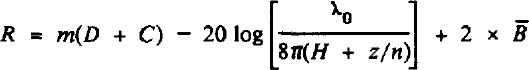
where m is gradient of calibration graph, C is constant determined by the intercept and the geometrical spreading term for the calibration flight, and D is digital value of signal strength. The only unknown remaining is B̅. This is determined by the complex dielectric permittivity, ε*, which is primarily a function of temperature and to a lesser extent impurity content and crystal fabric (Reference Glen and ParenGlen and Paren, 1975). Close to the melting point, B increases rapidly with increasing temperature and, as many of the glaciers in Spitsbergen have a significant proportion of ice near 0°C, the value of B in Equation (2) is of considerable importance in accurately determining R. For the majority of Spitsbergen glaciers the thermal regime is poorly known. There is considerable uncertainty in extrapolating results from one glacier to another (Reference ListølLiestøl, 1976; Zagarodnov and Zotikov, 1981). Consequently, mean absorption in the ice was calculated, where possible, from the variation of absorption with depth in the ice/bed interface echo (Reference BamberBamber, 1987, unpublished). This assumes that both the PRC and ice properties are invariant over the area covered. The justification for this approximation can be assessed by the spread in points about a fitted regression line. Data from glaciers with a correlation coefficient of <0.8 were rejected. Values for B were typically between 4.0 and 4.5 dB 100 m−1. The advantage of this approach is that it requires no assumptions about either the thermal regime or the dielectric properties of the ice. The attenuation, however, often showed a poor correlation with ice thickness (most probably due to variations in the bed-reflecting properties). For these glaciers, a linear temperature profile, with surface temperature T s = −4°C and the bed at the pressure-melting point, was used. The relationship between temperature and absorption was estimated from a combination of B values for glaciers with a reasonably well-defined thermal regime and measurements on the dielectric properties of a Spitsbergen ice core (Reference BamberBamber, unpublished). A simple linear temperature profile was employed for two reasons. First, more sophisticated models require additional boundary conditions and, given the large uncertainties involved in estimating these, the benefits of such a model are lost. Secondly, it simplifies the integration of the permittivity (with respect to depth). The greatest errors in this approach are not due to the uncertainty in temperature profile (changing T s from −4° to −1°C, for a 250 m column of ice, alters the total absorption by only 3.5 dB) but in the value of B assumed for a given temperature.
Errors
A least-squares fit was applied to the linear part of the calibration data (i.e. below the saturation limit of the receiver), the results of which gave a gradient m = −0.609 ± 0.016 dB/bit and an intercept C = 223.6 ± 2.7 bits. From these values, it can be seen that the power resolution of the digital recorder was 0.6 dB and that an error of approximately 2% ± 1.6 dB is introduced via calibration errors. They are, however, outweighed by the error associated with determining the dielectric absorption. This is ±2 dB/100 m maximum and is added cumulatively to the calibration error. Random errors in digitization are ±1 bit (0.6 dB).
Loss in signal strength due to bed roughness can reduce the mean PRC by between 0 and 15 dB (Reference NealNeal, unpublished) and must be considered when analysing the experimental data.
Hence, for typical values of D, there is a total measurement error of ±1.8 dB and a depth-related error of ±2dB/100m. This latter error expresses the maximum uncertainty in B and T and, for those glaciers (from the discussion that follows) whose thermal regime can be adequately estimated and/or where attenuation plots are satisfactory, the error is nearer half this value. For the ice/bed interface, the error will be between 4 and 12 dB. For those glaciers with a well-defined B however, it will be significantly less (3–7 dB).
Reflection Coefficients
Spitsbergen
The PRC data are summarized in Table I which also includes basic topographic information. The number preceding each ice mass indicates its location in Figure 1. Considerable variation in the bed PRC is observed and in some cases (e.g. Valhallfonna (35) and Olav V Land (34); Fig. 2) they are less than some of the internal reflecting horizon values (Fig. 3). This is a surprising result which, taken in isolation, might suggest a misinterpretation of an internal reflecting horizon for bed. It is important, therefore, to consider whether a bed PRC of the order of −40 dB (the lowest value measured for the bed) is physically possible. In north-east Spitsbergen, rocks are of the Middle and Lower Hecla Hoek complex and comprise greywackes, quartzites, and gneisses (Reference Hjelle and LauritzenHjelle and Lauritzen, 1982). Such rocks have a typical permittivity of about 5 (with a variation of between 4 and 9 (Reference ParkhomenkoParkhomenko, 1967)). For a solid, smooth ice/rock interface, this permittivity would produce a PRC of −19 dB. The rock types mentioned above are all relatively hard and resistant under normal surface conditions. It would seem reasonable, therefore, for them to possess metre-scale bed roughness which could reduce the echo strength by up to 15 dB (Reference NealNeal, unpublished), at best bringing the PRC to −34 dB. A second possibility exists if, instead of a solid boundary, a layer of debris-rich ice several metres thick were to be present close to the ice/bed interface. Debris-charged basal ice horizons have been reported from many Svalbard glaciers (e.g.Reference Boulton Boultonv 1970; Reference Zagorodnov and ZotikovZagorodnov and Zotikov, 1981) and core drilling through Hoganasbreen by the Norwegian mining company, Det Store Norsk Spitsbergen Kullcompanie, in 1985–86 demonstrated the presence of debris-rich ice extending up to 30 m above the bed (personal communication from A. Stensrud).
Table. I. Topographic, Ice Thickness, and RC Data For The Ice Masses Sounded In Spitsbergen In 1983

Note that blank spaces are present where no data were available. PRC data are averages along a flight line.
IRH stands for internal reflecting horizon.
* Denotes an ice cap. The literal translation of the Norwegian term, fonna, is snowfield or plateau glacier.
† Glaciers possessing IRHs but which were discontinuous and/or non-uniform in depth.

Fig. 2. Glacier profiles and PRC data for (a) Olav V ice cap (34), and (b) Valhallfonna (35).

Consider therefore a basal ice layer containing debris whose concentration increases linearly with depth from an initial volume concentration of 10%. If the Looyenga mixture formula (Reference Beekvan Beek, 1967)
is used to calculated the permittivity of the ice/debris mixture, then a PRC of −38 dB is produced. Hence a bed that is rough on a metre scale and/or overlain by a layer of debris-rich ice could explain the low PRCs. It does not, however, eliminate the possibility that returns are internal reflecting horizons (Reference Dowdeswell, Drewry, Liestøl and OrheimDowdeswell and others, 1984a; Reference BamberBamber, 1987). Comparing IRHs from glaciers that also have an unambiguous bed echo with the profiles in Figure 2, clear differences are apparent. The bed returns do not remain at a constant depth below the ice surface but vary considerably in their absolute elevation. Oscillograph and “A” scope records are also markedly different for IRHs and bed echoes (Fig. 3).
The PRCs in north-east Spitsbergen are about 20 dB less than those of valley glaciers sounded in the west. A distinct geographical trend is apparent and is illustrated in Figure 4. A concomitant trend is also observed in the mean absorption data B higher values (suggesting higher bulk ice temperatures) being found in western Spitsbergen and the lowest found in Ny-Friesland. It can be seen that PRCs >-15dB are found, almost exclusively, in Oscar II Land and James I Land, and those <-20 dB exclusively in north-east Spitsbergen (and Nordaustlandet; Fig. 5).

Fig. 4. Areal distribution of bed PRCs in Spitsbergen. No data were available for the unshaded areas.

Fig. 5. Contour map of bed PRCs in Nordaustlandet
The explanation for this geographical pattern is probably due primarily to differences in the thermal regime of the ice (as indicated by the absorption data). The rock type and bed environment may also play a part. It is believed that water is present within and at the bed of many of the glaciers sounded in western Spitsbergen (Reference BamberBamber, unpublished), while for the ice caps in Ny-Friesland it is suggested that they are probably frozen to their beds. Bed PRCs are very sensitive to the presence of water (Reference BamberBamber, unpublished) and the lower values virtually preclude the existence of even small quantities. This hypothesis is also supported by the north-eastern geographical location, altitude, and thinness of the ice.
In the following section the high PRCs (≈-10 dB) are investigated. They are observed on many of the valley glaciers in the west of Spitsbergen. The rock types in this area are more variable but are generally softer sedimentary strata. In the north (Albert I Land and Haakon VII Land), Lower Hecla Hoek rocks occur but with a more variable lithology (carbonates and quartzites) and are less resistant than those in the north-east. Further south there is a predominance of Triassic, Middle to Upper Carboniferous, and Permian strata — sandstones interbedded with siltstone, shaly siltstone, clay, and coal-bearing shales. These rocks are also less resistant, more soluble and erodable than those in the north-east and also have a higher porosity (personal communication from M.J. Hambrey). Saturation of a porous bed by water can increase the PRC by 10 dB or more (Reference BamberBamber, unpublished) depending upon concentration, electrical conductivity, and the rock type, and the high bed PRCs observed on many of these glaciers can be explained by a water-saturated bed although it is also necessary that losses from roughness must be small. Intuitively, these factors appear compatible as warm ice with water at the bed may result in basal sliding — a key factor in erosional (and bed smoothing) processes (Reference DrewryDrewry, 1986). The existence of internal reflecting horizons and heavy internal scattering on many of these glaciers supports the temperate-ice hypothesis (Reference BamberBamber, 1987, unpublished).
Nordaustlandet
Figure 5 is a contour map of PRCs for Austfonna. Figure 1 indicates the close network of radio echo-sounding flight lines over Nordaustlandet, which has allowed such a representation to be meaningful. Data from Vestfonna were intermittent and difficult to track (Reference DowdeswellDowdeswell, unpublished) and are consequently not shown. The general pattern on Austfonna is one of increasing PRCs from the centre of the ice cap towards the margins. It has been suggested that bulk ice temperatures also increase towards the margins (Reference BamberBamber, unpublished), so that there would appear to be a proportionality between temperature and PRC (as suggested for Spitsbergen). This phenomenon may be due to the existence of basal water in the warmer areas of ice. The distribution of sediment plumes around the coast of Austfonna (Reference Dowdeswell and DrewryDowdeswell and Drewry, 1988; Reference DowdeswellDowdeswell, unpublished) suggests that subglacial water is present in most of the areas which have the highest PRCs.
The absolute values of PRCs from Austfonna are relatively low for typical bed reflections (cf. Reference OswaldOswald, unpublished). They are similar to those found for the ice caps and glaciers in Ny-Friesland and Olav V Land, and are likely to be due to the same factors that determined the values there. Although water may be present over parts of the bed in Nordaustlandet, due to their more temperate nature, the glaciers in western Spitsbergen are likely to possess a much greater spatial concentration. Hence, the influence of water on the bed PRC in Nordaustlandet is likely to be more limited.
From the discussion above, and the trends in B , it seems reasonable to conclude that bulk ice temperatures become lower moving towards the ice crest of Austfonna and that there is a significant contribution to the PRC (≈10 dB), in the marginal zones, from the presence of water at the bed.
Extraordinary glacier profiles
In this section several glaciers with unusual properties are considered.
Vonbreen
This glacier shows a discontinuity in both the bedrock elevation (of about 80 m) and the bed PRC (5.5 dB) (Fig. 6). The oscillograph from this section displays a large hyperbola, indicating the presence of a “corner” reflector or discontinuity. The level and strength of the internal reflecting horizon appears to be completely unaffected, at this point, by the existence of the discontinuity, although its behaviour does vary up-stream.

Fig. 6. Glacier profile and PRC data for Vonbreen indicating the location of the discontinuity.
On the geological map (Reference Hjelle and LauritzenHjelle and Lauritzen, 1982), a major fault runs down Vonbreen valley. It represents the division between the Lower Hecla Hoek to the east (gneiss and granite) and Devonian (Wood Bay Formation comprising fresh or brackish water deposits) to the west. It is suggested that the discontinuity seen in Figure 6 marks the location of this fault. A similar fault has been assumed to run along the length of Isachsenfonna (which lies to the west and parallel to Vonbreen; Fig. 1) but no bed data were obtained from this ice mass.
Veteranen and Chydeniusbreen
Two other anomalous and interesting glacier profiles are those of Veteranen and Chydeniusbreen (Fig. 1). The profiles and PRCs are shown in Figure 7. These two glaciers were the deepest sounded in Spitsbergen (the ice thickness on Veteranen reached a maximum value of 656 m) and this in iteself may play an important role in explaining the observations. They are both from the “colder” and more “arid” part of Svalbard (Reference HisdalHisdal, 1985) and are probably underlain by harder rocks (Veteranen lies in a valley that separates the Lower from Middle Hecla Hoek — the former comprising gneisses and the latter greywackes and quartizites). The bed PRCs are intermediate in value (mean value of −23.2 dB) while the level of the internal reflecting horizon in these glaciers is deeper than is typical (Reference Dowdeswell, Drewry, Liestøl and OrheimDowdeswell and others, 1984b; Reference BamberBamber, 1987) for Syalbard glaciers and far from constant in depth. The two short sections of returns which come within about 150 m of the ice surface are clearly not bed reflections. This can be seen both from the oscillograph records (Fig. 8; marked A) and the fact that there is no expression of these major features in the ice surface. Their PRCs are, however, only about 5 dB less than those assumed to be of the bed. Furthermore, they are about IOdB stronger than the near-bed internal reflections appearing further up-glacier. It seems likely, therefore, that there may be two separate mechanisms responsible for the IRHs — the strongest down-stream echoes being due to the presence of water and the other possibly caused by a layer of debris-rich ice. The values of the PRCs are entirely consistent with these two hypotheses and it is interesting to note that the existence of the near-bed IRH coincides with the transition from one rock type to another, on both glaciers.

Fig. 7. Glacier profiles and PRC data for (a) Veteranen and (b) Chydeniusbreen

Fig. 8. A section of an oscillograph from Veteranen displaying the extraordinary internal reflecting horizon near the glacier snout (A) and the near-bed horizon further up-glacier (B). The location of the change in reflecting properties associated with a geological divide can also be seen (C).
The possibility that the internal horizon on Veteranen, starting at 19 km (Fig. 8; marked B), might be due to reflections from the side walls of the glacier can be dismissed. In the first instance, on several parts of the oscillograph records valley-wall reflections were visible as discrete targets having a range different from the internal horizon. Secondly, the reflector is too constant in both echo strength and continuity to be due to side-wall scattering. The IRH cannot be due to multiple reflections between the aircraft and surface as it does not have the correct time delay.
Even though the PRCs of the second, deeper IRH are lower than those from western Spitsbergen, they can still only be satisfactorily explained by a limited number of factors. The changes in permittivity or conductivity necessary to produce such values are of the order of 0.23 and 7.5 × 10⁻⁴ S m−1, respectively. They cannot be explained by density changes (an 8% change in bubble volume would be required), and the difference in [H+] necessary to produce the Δσ quoted above is of the order of 4 × 10⁻⁴ M (Reference MillarMillar, unpublished) and is clearly non-physical. The only mechanisms which are sufficient to produce the high PRCs observed are the presence of water and moraine. Using a model developed for evaluating the back-scattered power from inhomogeneities of arbitrary size (based on Mie scattering theory; Reference BamberBamber, 1988) it was found that, if the average radius of the debris (for rock of relative permittivity 9 and volume fraction 0.01) is ≈7 cm (equivalent to 7 rocks m−3) then the PRCs, for the near-bed internal reflection on Veteranen could be explained by this mechanism. There is a considerable amount of exposed rock in the vicinity of Veteranen which could give rise to the entrainment of moraine, and pronounced surface moraines occur on the glacier. The reflecting power is relatively constant locally (more so than typical bed profiles) and the topography of the internal reflector is very smooth. All these observations are consistent with a continuous layer of moraine entrained within the ice and deriving from near the head of the glacier. There are two major limitations to this hypothesis: the form of the IRH does not appear to follow a typical steady-state flow line, which would be a necessary requirement. Secondly, aerial photographs of the terminus do not indicate the presence of significant moraine near the snout. These two factors must, for a steady-state model, effectively eliminate the possibility of the internal reflecting horizon being due to entrained moraine.
The possibility that the reflection is due to water cannot be dismissed. The level and form of many of the single internal reflecting horizons in western Spitsbergen have been successfully modelled using Reference RøthlisbergerRöthlisberger’s (1972) theory of water pressure within englacial conduits (Reference BamberBamber, 1987). This was not possible for the internal reflecting horizon in Veteranen which seems to have very little relation to a steady-state piezometric surface. From the evidence available, it would appear that the most likely explanation for the deeper IRH is the presence of water, although it is not clear what regulates its level.
It was noted above that the Veteranen and Chydeniusbreen valleys are split by geological divides. Examination of the oscillograph record for Veteranen indicated that, at the point where the near-bed internal reflection begins, there is a dramatic change in the nature of the bed echo (Fig. 8; marked C). Examination of the digital data indicates that at this point the echo begins to become weaker and significantly broader, and in an interval of 12 s (equivalent to 720 m) the signal has beeen reduced by about 6 dB and is more “diffuse”. The point along track where this occurs coincides (within navigational errors) with the likely position of a geological boundary between Lower and Middle Hecla Hoek (Reference Hjelle and LauritzenHjelle and Lauritzen, 1982). The former, giving the stronger return, consists of high-grade metamorphic rocks (amphibolite, gneiss, psammite, and pelites), the latter of quartzites, greywackes, some limestone, and volcanic rocks (personal communication from M.J. Hambrey), and consequently has both different chemical and weathering characteristics. How this geological boundary might influence the existence and location of an internal reflecting horizon is not clear and it is possible that its presence is entirely coincidental. It is conceivable, however, that the change in reflecting properties, indicated in Figure 8, is due to the transition from an area with water present to one where the ice is frozen to the bed. If the geological divide is between rocks with different thermal conductivities, then it is possible that the slightly different geothermal temperature gradients, either side of the divide, might influence the location of the transition from frozen to wet bed. In the absence of field data, these hypotheses can only remain speculative. A bore hole and/or temperature data would greatly enhance the understanding of the processes governing these two ice masses.
Conclusions
An extensive radio echo-sounding data set has been used to produce power-reflection coefficients for the ice/bed interface over a large area of northern Svalbard. The absolute values have given clues to the possible environment at this interface and in particular to the presence of water, an essential requirement for sliding at the bed. Substantial regional differences in reflectivity and dielectric absorption were found and have been attributed to the change in climate across the archipelago.
A number of single internal reflecting horizons have been observed on data from the 1983 field season, most of them lying on the western side of Spitsbergen. The horizons observed on Veteranen and Chydeniusbreen appeared, however, not to possess the typical characteristics of those in the west and their origin is still unclear. Further data are essential to provide an unambiguous interpretation of these results.
Considerable success has been achieved in elucidating aspects of the “glacial environment” including the probable detection of two proposed geological divides, but with the use of finer along-track sampling, multiple frequencies, and/or a phase sensitive detector there is potential for far more information to be extracted from the radio echo-sounding data.
Acknowledgements
The author would like to thank Drs J.A. Dowdeswell, D.J. Drewry, and Professor G.K.C. Clarke for their advice and comments. Funding was through U.K. Natural Environment Research Council grant GR3/4463 and a NERC studentship to the author.


