

Introduction, Sources and Setting
Bede’s Historia Ecclesiastica covers the history of the Northumbrian people from the late sixth century into the middle of the eighth.Footnote 1 It is our nearest to contemporary source for key events in the seventh century but is nevertheless over a hundred years removed from what it describes. As a result, whilst this text is a valuable source, it is only the outline of historical events that is useful as a framing device for the present argument. Four major battles occurred in the seventh century involving Northumbrian rulers, all of which are mentioned in Bede’s work. Why they took place where they did and what the underlying reasons were for four successive monarchs falling in similar places does not form part of Bede’s narrative, outside of dynastic conflicts – as a result, it falls to modern scholarship to reassess these battles. The first was the Battle of the River Idle.
King Æthelfrith of the Northumbrians was killed by Edwin and King Rædwald of East Anglia in 616, at a place Bede describes as ‘at the limits of the Mercian people’ (ad finibus gentis Merciorum) by a River called ‘Idlae’.Footnote 2 Most correlate this location with the River Idle, which runs past Bawtry and several Roman roads in the South Yorkshire area. The Idle is one of several tributaries of the River Humber, which bisects central Eastern England creating a fenland area of criss-crossing marshlands and alluvium swamp. The Rivers Trent, Don and Torne are similar in this regard, and at the centre of this Humber Wash is an area known as the Isle of Axholme.
The Don would have also cut a slightly different path through the landscape in the early medieval period, prior to industrial drainage; meandering east to Crowle through the Hatfield Chase marshlands, reaching a confluence with the Trent near Adlingfleet.Footnote 3 The Trent was also one of the more unstable rivers in the country, prone to bursting its banks due to both tidal and river flooding.Footnote 4 The argument, then, is that the Isle of Axholme and its location within this tumultuous frontier washland made it a key point of articulation during the military and raiding campaigns of the seventh century between the peoples of central Eastern England. As evidenced by the name, the Isle was once indeed an island, or archipelago, depending on the level of the tide (Fig. 2). Axholme (‘Haxey island’) is formed from a compound of the ON personal name Hakr, OE -ēg (‘island’), and ON -holmr (‘island’).
Ermine Street spans the western borders of the Isle, otherwise surrounded by relatively impassable peat fens in the early medieval period.Footnote 5 Now a well-irrigated and peat-enriched expanse of farmland, this area of North Lincolnshire was once a key landmass in a flat and watery landscape (Fig. 1; Fig. 2). As argued by the wider works of Sarah SempleFootnote 7 and Nelleke IJssennagger,Footnote 8 watery places were ‘liminal zones’, areas on the edges of greater territories, and treated with some degree of reverence or, in some cases, distaste by contemporaries on drier soil. This liminality, as is the case with Frisia in the Low Countries – which is a key area of comparison – has led to the exclusion or marginalisation of these territories in contemporary and near-contemporary chronicling. From a historiographical perspective, this marginalisation takes the form of ‘othering’, with marshes being reimagined as ‘thin places’ where the physical and metaphysical realms collided, or as the habitats of strange insular peoples.Footnote 9 Historical chroniclers and hagiographers, as seen in their descriptions of Frisia and the South Lincolnshire fen,Footnote 10 were, thus, less interested in highlighting any sort of socio-economic or geopolitical importance for marshlands, for marshlands fit into a broader framework of ‘other’ places within early medieval literature, as seen for instance in Wulf and Eadwacer’s mention of the lagoons near Ravenna, Italy.Footnote 11 Yet, as will be seen, there is no doubt that there was significant economic interest in Lindsey, given the excavated evidence from Flixborough and relevant data from the Portable Antiquities Scheme (hereafter PAS).Footnote 12 Æthelfrith’s defeat on the banks of the River Idle is treated with a similar vagueness by Bede, concerned as he was with placing it in a wider narrative and religious framework; it remains the task of modern studies to determine an exact location.
Map of the Isle of Axholme and Lincolnshire in the early medieval period with titles for notable polities, Roman roads, and locations mentioned in the text. The coastlines and topography adapted from Green, Britons and Anglo-Saxons. Footnote 6 The Isle is highlighted in black, and the grey areas indicate low-lying tidally locked marshland.

Author-edited DTM (Digital Terrain Model) composite taken from LiDAR analyses of the Isle of Axholme, used to highlight the prominence of the archipelago’s low-lying hills in comparison to the Humber Wash. Image used with permission of Environment Agency, 2022.

Ermine Street runs through Bawtry and the nearby Roman fort at Scaftworth, connecting with Ryknield Street and thus both Danum (Doncaster) and Eboracum (York) – it is well-attested that Roman roads remained in use throughout the early medieval period.Footnote 13 They served as ‘army roads’ for the transit of peripatetic warlords. As a result, it seems highly plausible that Æthelfrith’s defeat could be placed along one of these roads near the Bawtry area, on the southern edge of the Isle of Axholme.Footnote 14 The emergent seventh-century polities of Mercia and Northumbria were divided by the River Humber; between them was not a linear frontier but a gradual ‘frontier zone’, an area in which the character of the residents may have changed within the bounds of the frontier.Footnote 15 The Isle of Axholme, positioned as one of the only areas of agriculturally viable and dry land within this frontier zone (Fig. 2) – enriched as it was by layers of peatFootnote 16 – will have been a notable and important district geopolitically, its inhabitants swaying to either a more ‘Northumbrian’ or ‘Mercian’ character, or perhaps retaining their own unique identity. It is here where Leahy and Green’s studies on the kingdom of LindseyFootnote 17 can be best used to assess the character of the Isle of Axholme in the seventh century, and from there, a new understanding of Northumbria’s southern frontier, the edges of Lindsey, and economic, ritual, and geopolitical reasons why three – possibly four – Northumbrian kings were defeated here.
The Battle of the River Idle served only as a prelude. Around seventeen years later, King Edwin would be defeated in ‘a fierce battle at the plain called Heathfelth’ (conserto gravi proelio in campo qui vocatur Haethfelth),Footnote 18 widely believed to be identical with Hatfield Chase, near Doncaster, which falls on the western perimeter of the Isle of Axholme. Almost a decade after that, King Oswald fell at Maserfield or Maes Cogwy, a location which evades modern identification, although toponymic arguments have been raised for Oswestry near Shropshire, Coccium (Wigan), and Makerfield in Lancashire.Footnote 19 In 679, King Ecgfrith was defeated ‘near the River Treant’ (iuxta Fluvium Treanta)Footnote 20 in a conflict against King Wulfhere and the Mercians. Whilst the exact location of the Battle of the River Trent is as historically unidentifiable as the Battle of the River Idle, a reasonable deduction could be made that it occurred somewhere near Flixborough, given the material evidence cited later. Somewhere between Scunthorpe and Immingham is another possibility, though it rests on a correlation with a toponym and the character of Imma, mentioned by Bede as one of Ecgfrith’s loyal men captured after the battle.Footnote 21 To the east of the Isle, over the River Trent, is the toponym Immingham, from *Immingahām or ‘the estate of the followers of Imma’. Whilst this is probably a coincidence, the Battle of the River Trent is nevertheless placed east of the Isle at an unknown location. The Battle of the River Trent followed a lesser-known successful campaign of King Ecgfrith beyond the southern frontier, dated to 674 by P. Hunter Blair.Footnote 22 This campaign, mentioned in the ‘Moore’ manuscript, took place within the bounds of the kingdom of Lindsey.Footnote 23
From this introduction, then, it seems clear that to better investigate the turmoil and geopolitics of Northumbria’s southern frontier in the seventh century, and why the kingdom’s monarchs so frequently fell near this frontier, is to dissect the archaeological, historical and toponymic information available to us concerning that ever-present central point of articulation, the promontory that lay north of the Battle of the River Idle, east of Heathfelth, and west of the River Trent: the Isle of Axholme (Fig. 3, and cf. Fig. 6).
Detailed map of the Isle of Axholme in the early medieval period and the surrounding alluvium swamplands, displaying the modern names of its parishes, towns, and villages, some mentioned in the text. Ermine Street’s route is also depicted.

Lindsey, Hatfield and Axholme
In discussing the Isle of Axholme, it is necessary to interrogate the sources and information about the kingdom of Lindsey.Footnote 24 It is poorly understood through contemporary documentary sources, excluded for the most part from the Anglo-Saxon Chronicle, and lacking its own narrative history. In this regard, Lindsey is similar to Mercia, although, due to being annexed at some point in the seventh or eighth century, it has even less of a documentary presence. One thing both kingdoms share with Northumbria is that they may all, at one point, have included the Isle within their political bounds. First historically recorded in the 1115 Lindsey Survey as Haxeholm,Footnote 25 the Isle has evaded serious academic research outside of antiquarian interest in the seventeenth and nineteenth centuries, and is featured only sparingly in wider works dedicated to Lindsey such as Leahy’s The Anglo-Saxon Kingdom of Lindsey and Green’s Britons and Anglo-Saxons: Lincolnshire. Recent works have begun to redress this lack of focus.Footnote 26
Wider Lindsey
The foundation provided by previous scholars has developed into a solid understanding of the wider kingdom that the Isle may have formed part of: Lindsey. Green has convincingly argued for the existence of a fifth-century polity centred around Lindum Colonia (Lincoln), based on Late British etymology and the extended archaeological investigations of Kevin Leahy into the wider Lincolnshire inhumation and cremation cemeteries.Footnote 27
These cemeteries, as discussed by Green, form a < 25 km radius around Lincoln until the late fifth century (Fig. 4), when the material assemblage changed, and Lincoln lost that insular Late Roman character that it had maintained. Green’s Lincoln-based polity has been given the speculative name of *Lindēs and is understood to be a somewhat proto-urban diaspora centred around and within the walls of the former Roman colonia, extending no further than a few kilometres in all directions, though strong enough to hold back a tide of Anglian migration, or to install mercenary groups in specific locations. The Isle falls outside this ring of migrant cemeteries and, as will be demonstrated later, is likely to have also been of mixed linguistic and ethnic makeup (Fig. 4).
Map displaying a selection of cremation cemeteries in Lincolnshire. Note the crescent shape around Lincoln. This is believed to represent several fifth-century groups being ‘repelled’ by an insular polity until the sixth century, when Lindum Colonia was also settled by incoming Germanic -speaking migrants.

It was *Lindēs which was, by the sixth century, transformed by an emergent cluster of Germanic-speaking tribal or kin groups centred around the Lincolnshire Wolds. This merger, violent or otherwise, ultimately became known as Lindissi or Lindsege, and later Lindsey. The genealogy for Lindsey, found in the ‘Anglian Collection’, indicates a significant crossover between Anglian and Brythonic identities and linguistic elements, to the point where Lindsey might be best described as an Anglo-Brythonic polity within central Eastern England.Footnote 28 Various high medieval works also focus specifically on the Brythonic characteristics of Lindsey,Footnote 29 and John T. Koch’s translations of Y Gododdin recalls ‘men of Linnuis’ active in the poem’s central conflict.Footnote 30
It is important to discuss this background, in order to highlight the liminality within Lindsey of the Isle of Axholme, peripheral even to an already-peripheral kingdom. The Isle goes largely unmentioned in Leahy and Green’s studies and, indeed, until 1974 was not even necessarily part of North Lincolnshire specifically. Instead, the Isle was considered its own rural district within Lincolnshire, and in 2023 was assimilated into Doncaster East. The Isle, then, maintains a unique character in modern times and this does, indeed, reflect historical traditions. Whereas nowadays the Isle and Islonians flit between Nottinghamshire, South Yorkshire, and North Lincolnshire dialects and affinities, in the early medieval period it is clear that the Isle jutted simultaneously onto the frontiers between Lindsey, Mercia, and Northumbria.
Hatfield and Northumbria’s Southern Frontier
The Isle was included in the Lindsey Survey, dated to 1115, a document related to Lincolnshire’s Domesday assessment, which can be seen as a plausible template for the early medieval dimensions of the kingdom of Lindsey; however, it only appears as an outlying promontory near what might be a monastery at Adlingfleet.Footnote 31 The Tribal Hidage, a probably eighth-century source, values Lindsey at 7,000 hides along with its subsidiary regio of Hatfield (‘Lindisfarena med Heathfeldland’).Footnote 32 Hatfield remains understudied even in comparison to Lindsey, but can be best understood as an area of minimal autonomy, or perhaps even unsettled or sparsely settled land, juggled between Mercia and Northumbria.Footnote 33 The Whitby Life of Gregory the Great describes Hatfield as a regio, and places the remains of King Edwin, after his death at Heathfelth, somewhere within this regio near the edges of Lindissi. In this narrative, a character is contacted and told to speak to a knowledgeable individual ‘in a village in Lindissi’ who knew of the location of Edwin’s remains.Footnote 34 Both regio and provincia are used by Bede to describe Lindsey, the former seemingly a term used for semi-autonomous polities below the tier in which Mercia, Wessex and Northumbria operated.Footnote 35
While Green has argued successfully for a degree of autonomy and independence in the early sixth century, Lindsey was most likely already under the dominion of either Northumbria or Mercia by the time of Æthelfrith, or through his conquests. Guy Halsall and Nicholas J. Higham have otherwise argued that the frequent raiding and inter-border warfare along this southern Humber-based frontier is indicative of a contemporary need to reaffirm and reassert overlordship over petty territories, in this case, Lindsey itself.Footnote 36 These actions formed part of a ‘grammar of warfare’Footnote 37 and violent display. The fact that so many of these assertive raids occurred in Lindsey might be emblematic of that aforementioned independence. It might well be the case that Lindsey was an unyielding subservient polity, and so required frequent raiding as a form of political pacification.
The annual raiding cycles and military operations posited by HalsallFootnote 38 may lie behind the deaths of Æthelfrith, Edwin and Oswald, all occurring within a decade or more of one another. These reigns all saw a need for Northumbrian expansion, too, and a desire to subjugate and extract tax from client states on a seasonal basis.Footnote 39 It is no wonder, then, that a significant portion of Bede’s narrative is dedicated to Lindsey and this frontier specifically, especially considering that, as client states go, it was comparatively wealthy, to judge from its assessment in the Hidage at 7,000 hides. This total has been argued to be a ‘nominal value’ attributed to regiones or petty kingdoms lacking in full autonomy.Footnote 40 Inferred to be just south of the territory of the Lindēsfaran, a large number of petty kingdoms are mentioned whose names suggest a location around the South Lincolnshire and East Anglian fenlands, such as the Gyrwe and Spalde, cumulatively valued at 6,900 hides (Fig. 5). The total hidage value attributed to the dozens of polities south of Lindsey would, in this case, be emblematic of unlinked territories which together held the same political and economic value as Lindsey – a nominal value representing a regio. Footnote 41 Given that Lindsey’s value is just 7,000, it is quite plausible that it was calculated from similar petty groupings within and around Lincolnshire and the Humber Wash.
Map of the territories mentioned in the Tribal Hidage.

The Isle of Axholme fits into this narrative of Lindsey as the westernmost dry land before one travels onwards to Hatfield, an otherwise marshy flatland. As mentioned earlier, the Isle slots between multiple vital riverine routes and alongside Roman roads. Field walking surveys of the Isle and surrounding areas since the eighteenth century have indicated an array of Neolithic trackways which were repurposed and reused in the early medieval period, notably linking Flixborough in the east to Adlingfleet in the west.Footnote 42
These trackways bisect the Isle, and may have been constructed of timber panels laid over packed earth,Footnote 43 hinting at a network of interactivity and transit across the archipelago. Aside from a few overviews of the district in the nineteenth century, formal study of the early medieval Isle has been confined to toponymic assessments.Footnote 44
The Isle: Economic and Spiritual Liminality
Using such information, it is plausible to suggest that many early kin groupings emerged in and around the Isle, too. There is an abundance of toponyms which feature the -ingas- connective element, such as Burringham, Messingham, Luddington, Winteringham, Walkeringham, Beckingham, Rossington, Corringham, Willingham-by-Stow, and Finningley, many denoting ‘the ____of the folk of ____’.Footnote 45 These toponyms likely reflect competing identities centred around the notable landmass of the Isle, as a central point amongst the surrounding marshlands and the nearby chalk wolds (Fig. 2). Kathryn Bullen’s thesis explores these various linguistic groups that have impacted the area from the first to the eleventh centuries, and beyond. Notably, there is a myriad of Old Norse-influenced toponyms, which lines up with Hadley and Richards’ work tracing Viking Great Army activities across England.Footnote 46 In a recent volume, Shane McLeod has convincingly demonstrated, using metal-detected evidence, that the Isle was used as a transitory staging point between York and Torksey as a temporary camp for Viking armies.Footnote 47 The Isle’s location as the last viable piece of land, before an array of rivers and marshes, marked it as a key strategic point of articulation, and an evident border between territories – notably so, for a martial society that excelled in boat-building and maritime travel. Max Adams, in a similar vein, has argued for a ‘subway station’ model for analysing the travel of maritime peoples through the North Sea and connected estuaries and marshlands. In this vein, fens and swamps functioned as ‘changeover stations’; areas of increased cultural, material and commercial exchange.Footnote 48 As will be discussed later, this correlates with the currently available PAS data for Lincolnshire.
Dore and Whitwell, south of the Isle, and mentioned in near-contemporary chronicles as a staging point between Mercian and Northumbrian territory in 827, and again in 942,Footnote 49 have been argued by David Rollason to be evidence for an earlier border point between the two kingdoms.Footnote 50 Given both Dore and the Isle’s importance in the Viking Age, a period when the frontiers of kingdoms were fragmented and reshaped, it seems plausible to posit that the Isle held greater importance in the preceding centuries. It may well have served as an earlier point of articulation to Dore, whose significance emerged in the later Viking Age after the reshaping of pre-Viking Age borders.
The few archaeological investigations around the Isle have revealed a small handful of Grubenhäuser in Belton, Roman grey-ware sherds across the edges of Hatfield, Iron Age roundhouses in Sandtoft, and a scattering of Neolithic and Bronze-Age earthworks in Beltoft and at Owston Ferry, once known locally as ‘The Giant’s Graves’.Footnote 51 There was also, until the late twentieth century, an extant spring locally believed to be a historical ‘healing pool’ dedicated to St. Oswald near Low Burnham, which will be discussed later in connection with Maserfield. Notably, some of these earthworks, as described in the nineteenth century, are now completely absent due to modern agricultural developments. In recent years, the PAS has highlighted the presence of material belonging to both North Sea and insular Late Roman artefactual types, and also items of plausibly Kentish or Merovingian influence in Haxey (Fig. 7).Footnote 52
Map of the Isle of Axholme highlighting the suggested locations of three of the battles mentioned in the text; Idle, Hatfield and Trent.

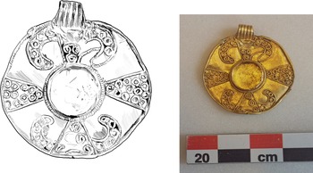
Author’s illustration of a gold alloy pendant (LVPL-C2D4CE) discovered near Haxey church and dated between the seventh and eighth centuries, plausibly the possession of a wealthy individual. Its presence within the Isle is of considerable interest for the wider arguments of this paper, reflecting a greater socio-economic status for the archipelago, or at the very least visitors of a ‘noble’ character. An identical pendant was discovered near Skegness. Image courtesy of the Portable Antiquities Scheme/Trustees of the British Museum.

The toponyms that make up the parishes and villages of the Isle of Axholme, as discussed, also display a variety of origins. Belton is perhaps the most interesting, situated amongst a cluster of Bel- prefixes (Belgrave, Belgathorne Hill, Belwood, Beltoft, Belshaw) all perhaps denoting either a lost landscape feature (which would correlate with the ‘Giant’s Graves’ mounds, also lost) or a divine figure. This prefix has been the subject of much etymological scrutiny, although Bullen has convincingly argued it likely denotes a ‘particularly dry area of ground in a marsh’, making it recognisably distinct within the landscape. This would explain the close cluster of toponyms.Footnote 53 However, this does not exclude the possibility that the Bel- element may have been knowingly proliferated within the local environment on the Isle of Axholme as an identifying marker, as will be expanded upon shortly. Sarah Semple, among others, has argued for a spiritual reason for the locations of certain early medieval communities and battles, and the plethora of both visible and lost prehistoric landmarks around the Isle would certainly fit that assumption, as would the large bodies of water and fenland that surrounded the place.Footnote 54 David Wilson postulated that Easole, in Kent, may derive from OE ‘god’s spur’,Footnote 55 and on that same note, the Ealand in the Isle might very well derive from ‘god’s land’, further indicating spiritual associations for the archipelago. The etymology of Ealand would suggest it derives from ‘island by water’ but a double meaning for the name, recognised at the time of its currency, is not impossible.Footnote 56 Deriving from a different – Christian – context, near Crowle, is the toponym of Godney Bridge; possibly from OE ‘God’s Island’.Footnote 57
Equally, an assertion could be made that the high number of -ingas- toponyms around the Isle correlates with the aforementioned pre-Roman tumuli and that these were prehistoric features used to cement a sense of belonging and tribal identity back through time. Natural borders, such as the tributaries of the River Trent that surrounded and, at times of high tide, bisected the Isle, would have also served as recognisable divisions between territories. Interestingly, in 1747, the mummified remains of a woman were discovered that have since been tentatively dated between 200–400 CE.Footnote 58 This individual, termed ‘The Amcotts Lady’, had been submerged upright near the eponymous village on the very edge of the River Trent. Nearby, across the Thorne Moors to the west of the Isle, was found a dismembered arm complete with an Iron Age torc attached.Footnote 59 Both of these bog burials were found in liminal places and on geographic borders, quite possibly reflecting tribal divisions and areas where one ‘polity’ ended and another began, as can be observed through parallels in contemporary Irish bog burials.Footnote 60 It is very possible such borders were reaffirmed beyond the Iron Age and Roman period and repurposed by early medieval societies through an acknowledgement of the extant monuments, as seen elsewhere across England and, indeed, more widely in Europe. Prehistoric tumuli are often observed as having been reused as land-markers between farmsteads and larger polities in the early medieval period, and this was evidently also the case in the Isle, given the toponym ‘Barrow Furlong’ in Belton.Footnote 61
All of this is to comment on the fact that it is likely the Isle, and its immediate surroundings, were home to a diverse array of competing kin groups in the early medieval period, as evidenced by toponyms and supported by other pieces of information. Indeed, any area with a high concentration of -ingas- toponyms could be described similarly, but for the Isle, the reason for this can be plausibly linked to the character of the surrounding topography; the Humber Wash connects an array of landing points,Footnote 62 and the Isle and the chalk wolds to the east will have been valuable areas. This further demonstrates why the southern frontier of Northumbria seems to terminate around this point specifically. If we use Higham’s ‘frontier zone’ model for the Humber Wash then it seems realistic to postulate that the competing kin groups around the Isle, as observed through toponymy, were all part of a united ‘frontier’ character.Footnote 63 This would then line up with Myres’ Humbrenses argument based on Sancton-ware pottery and its distribution across both sides of the River Humber, along with wider readings of charters and documents from the eighth century that use ‘Humber’ as a descriptive element for various peoples, implying that the river was not the boundary but the bridge that united them.Footnote 64 Rollason also argues that ‘the North-Humbrians’ were a new political entity even in Bede’s time, and that this geographic descriptor became popular to describe miscellaneous confederacies north of the river. Myres’ pottery-based argument was that the Humber linked similar yet disparate communities across the waterways themselves. While this is an old discussion, Myres’ Humbrenses theories correlate with modern analyses of the origin of the name ‘North-Humbrians’, and the nature of the River Humber as a ‘boundary’. While these wetlands have always functioned as something of a central limit, the Humber should not solely be seen as a prohibitor to movement but, following IJssennagger’ s research in Frisia, more of a ‘poly-ethnic transitional region’, home to various multi-layered and competing hybrid identities.Footnote 65 A bridge, not just a barrier.
Flixborough and the North Sea Economy
Wetlands also functioned as connective tissue within England and across the North Sea. Once again, comparisons with Frisia as a ‘central because liminal’ zone are fruitful. Seventh- and eighth-century North Sea pennies are a further link between these two locations; out of the entirety of England, the PAS count for Lincolnshire is the highest at 405.Footnote 66
The reason for this is debatable and could be down to discovery bias, but it is plausible that the marshy alluvial character of much of Lincolnshire and the East Anglian fen is responsible; these watery places were largely impassable on foot but for a maritime society they became ‘changeover stations’.Footnote 67 In the North Sea exchange network, areas of tidally-locked coastal marshland will have acted as extensions of the sea and, thus, would have been ripe for maritime harbours and trading zones. In addition, one could attribute the spread of this transferable currency across Lincolnshire to the Frisians, who were prolific traders and crafters across the North Sea during the seventh century.Footnote 68 It seems plausible, then, that the proliferation of these coins – and thus trading centres – across these areas, notably Lincolnshire, was due to the geography. Kevin Leahy has argued that Lindsey had no major wic site like other kingdoms and had, instead, a ‘network’ of trading centres much in the same way that there was a network of monastic sites within the county, too. There is even the likelihood that secular and spiritual sites were specifically paired.Footnote 69 One of the wealthiest of these productive sites, and indeed the wealthiest rural early medieval settlement ever discovered, is Flixborough.
Flixborough lies to the immediate east of the Isle of Axholme and the excavation reports of Christopher Loveluck provide a thorough overview of the settlement’s history over a thousand years.Footnote 70 By the end of the eleventh century, Flixborough’s archaeofaunal assemblages demonstrate a wide array of cetacean remains. These animals were likely hunted via whale drives in the shallower waters beside the Isle of Axholme, though this practice is not mentioned in the contemporary Ælfric’s Colloquy, which only specifies that whales were caught generally.Footnote 71 In this regard, the Isle was the immediate hinterland for the site; its residents likely facing eastward with local commerce and subsistence aimed in that direction over the River Trent – as a result, Flixborough and the Isle are intimately connected. This is supported by PAS evidence: the Isle’s metal-detected record from < 650 CE onwards is dominated by net-sinker weights of the ‘Flixborough’ type, a locally manufactured fishing tool made at the settlement for use in a regional maritime subsistence economy.Footnote 72
Contemporary with these weights, Flixborough’s earliest phase indicates that the site grew from a seasonal market centre to a regionally important productive site, much in the same manner that the Frisian colony at Fishergate developed in York.Footnote 73 Charnwood-ware appears frequently in the artefactual record, along with a small number of residential buildings and, by the late 600s, material from the Rhineland, indicating a significant degree of international trade.Footnote 74 Flixborough may have also held a dual function as both a wic and a monastery, given the later significant presence of styli and cattle remains from the production of vellum. A definitive conclusion about Flixborough remains to be reached, but nearby excavations and preliminary investigations into the earthworks at Halton Park and West Halton indicate that the site may well be linked with the Alftham mentioned in the 679 entry of the Liber Eliensis as a late seventh-century Northumbrian monastery on the southern border.Footnote 75 Granted, this is a twelfth-century source, that likely drew on an earlier, lost hagiography of Saint Æthelthryth, so an exact equation cannot be reached. The Flixborough site is the most likely estimate other than another, unrecorded, and unexcavated monastery. It has more recently been suggested that Flixborough was a key ‘exchange node’ and ‘rich minster’ amidst wider international trade networks; the archaeofaunal assemblages indicate a multi-faceted busy domestic role with links to nearby arable and agropastoral terrain, but also across the North Sea.Footnote 76
Flixborough was a very wealthy productive site, one of several in a county that has been recognised through the work of the PAS as inordinately abundant in terms of loose penny finds (Fig. 8). These have not been found in hoards, and so likely indicate that there was a comparatively high degree of inter-societal trading within Lindsey, alioning with Sindbæk’s exchange model for Viking Age Scandinavia.Footnote 77 From this point of view, Lindsey’s relative absence from the documentary record becomes more interesting. If it was truly one of the richer areas of the British Isles in the seventh century, then the fact that it was repeatedly raided by Northumbria and Mercia, and juggled between them during the reigns of multiple monarchs, seems explicable. Flixborough’s position, right on the very northern limits of Lindsey, directly parallel to the Isle, supports the idea that both the Isle of Axholme and this northern frontier served as key points of geographic and socio-economic articulation along these kingdoms’ shifting borders, and were a heavily contested area.
Bar chart of the nine highest penny/sceatta counts on the PAS across the country, measured by the density of finds (quantity of sceattas divided by county dimensions in kilometre-squared), segmented by modern unitary authority.Footnote 78 This demonstrates the greater notional percentage of pennies per square kilometre across the Lincolnshire region and its surroundings.

The Isle has long been recognised also as an area of strong agricultural potential; antiquarian studies since the seventeenth century have remarked upon the extraordinary layers of peat which have led to a very bountiful seasonal yield.Footnote 79 The economic assessments of the Isle in Domesday Book also indicate a spread of reasonably wealthy agropastoralist settlements, with considerable industry relating to marine subsistence. Crowle, for instance, whose toponym derives from OE cruw (‘at the river bend’), held thirty-one fisheries yet only housed thirty-four total residents.Footnote 80 Given the Isle’s agricultural and marine capabilities, and the fact that Flixborough has been recognised as a very wealthy site, an economic explanation for the frequent seventh-century battles can be put forward, to go alongside the ‘ritual’ argument as suggested earlier with the barrow mounds, the status of watery places in contemporary literature, and Semple and Halsall’s wider comments about prehistoric monuments and raiding cycles.
Summary
To conclude this segment, we must return to the toponyms of the Isle of Axholme, principally those that feature the -ingas- element, and apply to them broader theories about warfare and over-kingship. Both David Dumville and Thomas Charles-Edwards, among others, have convincingly demonstrated how many kings were subservient to overlords.Footnote 81 The many -ingas- place names, alongside this paper’s earlier argument for their being representative of competing kin groups may, in this case, be evidence of petty rulers operating under either Northumbrian or Mercian hegemony along this liminal borderland. Almost all the opposing parties involved in the battles between 616 and 679 are described by Bede as having under-kings or sub-rulers supporting their own forces.Footnote 82 Each army was, then, a confederacy of linked peoples whom a single overlord (for instance, King Penda of Mercia or King Oswald) oversaw. The Isle, this rich and resourceful area of land situated at the centre of a demonstrable frontier zone, complete with prehistoric landmarks and -ingas- place names, and near to Roman roads and vital navigable waterways, along with an extremely wealthy, rural productive site at Flixborough, seems a very viable location to suggest as an area of client kingship. This would not necessarily conflict with Caitlin Green’s arguments for a Brythonic polity of *Lindēs and its broader cemetery assemblages. The Isle is not only north (and thus outside) of her observed ‘cemetery radius’ but also was only just included in the aforementioned Lindsey Survey, so might well have been considered part of the regio of Hatfield instead, or as its own distinct micro-territory.Footnote 83
This section has brought together many interdisciplinary strands of information about the geographical, spiritual, and socio-economic position of the Isle of Axholme, demonstrating why battles were likely to occur in the vicinity of an area with such a character. It should, therefore, be of interest to assess the relationship between the Isle and these major battles specifically.
The First Fallen King: At the River Idlae
Following Bede,Footnote 84 the Anglo-Saxon Chronicle also describes Æthelfrith’s death in 616, highlighting the dynastic elements of the conflict between him and rival Edwin:Footnote 85 ‘Æthelfrith of the Northumbrians was slain by Rædwald king of the East-Angles, and Edwin the son of Alla succeeded to the kingdom …’ While there is no mention of the site itself, the two armies would have most likely met along one of the Roman roads knitting together the frontiers of the peoples north and south of the Humber. Using Bede’s identification, this would place the conflict either along Ermine Street directly, near Bawtry or Scaftworth, or on one of the two identified branches of Ermine Street that run through modern Nottinghamshire: the Fosse Way that connected Ratae (Leicester) to Lindum Colonia and then the connecting route from there to Segelocum (Littleborough), and thence through Sturton-le-Steeple, North Wheatley, Clayworth and Bawtry to Danum (Doncaster).Footnote 86 To the east of this thoroughfare was the River Trent, cutting a wider path than it does today. In 1810, repair initiatives on the wooden bridge at Till Bridge Lane revealed layers of pre-Conquest material beneath the peat, which once acted as a causeway over the surrounding floodplains and as an extension of the pre-existing Roman road, which terminates at the Trent and does not extend eastwards into the Humber Wash.Footnote 87 Bawtry, then, positioned on the eastern banks of the Idle and, principally, along these roads used for military campaigning, seems as good a guess as is possible for the location of the battle. There is also burgeoning evidence that Bawtry had a small Roman fort; aerial photographs have revealed roughly 0.4 hectares’ worth of ditches and earthwork internments, though this evidence demands further analysis.Footnote 88 If the presence of a castrum at Bawtry can be confirmed, then it is possible that the Battle of the River Idle was fought around the fort and was not an open-country encounter.
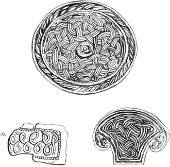
The identification of Æthelfrith’s defeat with Bawtry would make this into a conflict on Northumbria’s southernmost border, involving late Roman earthworks at Bawtry and Scaftworth and following the course of pre-existing roads. The Isle of Axholme, just north of Bawtry, may well have been a prominent and visible landmass, distinguishing where one territory ended and where another began. Ermine Street, the road postulated to have been the route of King Rædwald and Edwin to the Battle of the River Idle, is also overlooked, further south, by the Caenby barrow mound, discovered in 1849. When excavated, this revealed an early medieval elite burial assemblage, displaying Roman, North Sea and insular artistic affinities (Fig. 9).Footnote 89
Illustrations of the Caenby barrow mound assemblage, drawn by Edwin George Jarvis in 1849. Adapted from Jarvis, ‘Account of the Discovery of Ornaments and Remains’.

Again, like the tumuli across the Isle of Axholme, this was an earthen monument situated in a place visible along areas of frequent mobility; an imposing structure for others to look upon on their way into or through a territory. It is worth mentioning yet again that while the Isle was included in the Lindsey Survey, it seems clear that its character was more of a nebulous frontier zone, with Flixborough as a possible entrepôt between kingdoms (Mercia, Northumbria, Lindsey). Following the Battle of the River Idle, the contemporaneous occupational layers of Flixborough only display an increase in the local economy; locally produced and imported pottery wares, and an uptick in the creation of structures indicated by the presence of post-holes. It is possible that this could be attributed to the oversight of a new Northumbrian ruler, this being King Edwin. However, within seventeen years, King Edwin would also be defeated, merely twenty kilometres north of the site of his predecessor’s defeat.
The Second Fallen King: At Heathfelth
‘This year [632/633] king Edwin was slain by Cadwalla and Penda at Heathfield on the second before the Ides of October, and he reigned seventeen years; his son Osfrid was also slain with him. And after that went Cadwalla and Penda and laid waste the whole country of the North-humbrians…’.Footnote 90 As the ASC and Bede state, this was the Battle of Heathfelth (Hatfield Chase), between King Edwin of Northumbria and an opposing coalition led by Cadwallon of Gwynedd and Penda, a heathen warlord from Mercia. Whilst the religious undertones are obvious and come through plainly in Bede’s text, we cannot overlook the geographic proximity to Edwin’s predecessor’s death, just twenty kilometres south at Bawtry. Again, the Roman road of Ermine Street which cut alongside the bogland expanse of Heathfelth appears to have been the main thoroughfare leading these two armies against one another.
Heathfelth has long been equated with Hatfield Chase by scholars such as Parker and Breeze, though there is an emerging body of metal-detected and church-dedication evidence which might shift the conflict southwards near either Edwinstowe or Cuckney, near Mansfield in Nottinghamshire.Footnote 91 Cuckney is significantly further away from the Isle of Axholme than Hatfield Chase but neither attestation is currently certain, so for present purposes, we will endorse Hatfield Chase. In doing so is to recognise once again the proximity of the Isle to this second conflict, to the immediate east of Hatfield. Etymologically, Heathfelth hails from OE ‘hǣð’ (a tract of open or uncultivated land) and ‘feld’ for field.Footnote 92 This whole territory, a regio or petty polity, was a horizonless wetland, whose main settlement appears to have been Stainforth, the very name of which indicates a crossing point: Stenforde from ON ‘stone ford’.Footnote 93 Like Frisia, the terrain of Heathfelthland would have made it into a bit of a ‘transitional region’,Footnote 94 which raises questions about the actual linear limit (if there ever was one) of Northumbria. King Ecgfrith is referred to in 680 as ‘king of the Humbrians’ (Ecgfrido rege Humbronensium),Footnote 95 and later the Northumbrian U-text of the Canones Theodori uses the phrase ‘Humbrian disciple’ (Discipulus Umbrensis),Footnote 96 further indicating that Northumbria’s dominion extended south of the Humber.
There is also a second description of this battle. The Annales Cambriae (c. 829) describes the location as not Heathfelth but ‘Gueith Meicen; and there Etguin was slain with his two sons’ (Gueith Meicen; et ibi interfectus est Etguin cum duobos filiis suis), an entry the Historia Brittonum expands upon.Footnote 97
Gueith Meicen, et ibi interfectus est Etguin cum duobus filiis suis; Catguollaun autem victor fuit.
Duo filli Edguin erant, et cum ipso corruerunt in bello Meicen, at de origine eius numquam iteratum est regnum, quia non euasit unus de genere illius de isto bello, sed interfecti omnes sunt cum illo ab exercitu Catguollauni, regis Guendotae regionis.Footnote 98
Meicen may be the original Brythonic name for Heathfelth. This is not an unlikely suggestion, given that Green has already demonstrated Lindsey, just to the east, also had a Brythonic name before anglicisation, and so too did Nottingham and ‘regione Dunutinga’, nearby polities which formed a network of overlordship for seventh-century Mercia and Northumbria.Footnote 99 If Meicen is Heathfelth then what of ‘Gueith’? In a poem from the Book of Taliesin, Gweith Gwenystrad, ‘Gweith’ means ‘work’, ‘fortification’, or ‘battle work’, quite possibly in reference to an extant Roman fort. Elsewhere it might generically mean ‘action’.Footnote 100 Gueith Meicen might then be ‘the fortification of Meicen’ with Meicen itself later descending into OW Maigen which means ‘battle’.Footnote 101 Ultimately the meaning of Meicen is unclear but, interestingly, just east of Hatfield on the edge of the Isle of Axholme is the village of Wroot (from OE Wroth meaning ‘snout of land’), which until recently was located near a dried lake referred to locally as Lake Meisen (and variations thereof; Messen, Misen, Misna). This is a similar root for the modern village of Misson, near Wroot, and another large body of water by the Isle – Messic Mere – was also once located nearby.Footnote 102 It is not implausible that, through folk etymology and a descent through Late British/Old Welsh/Old English, Meicen became rendered as Meisen. There is also the extant toponym of Messingham, east of the Isle, which derives from the OE ‘the estate of the people of Maessa’.Footnote 103 Again, it is possible this name derives from Meisen and OW Maes. This presumed Brythonic name for Heathfelth appears in some form across numerous Old Welsh works and given Kathleen Hughes’ argument that most of them – notably the Annales Cambriae – descended from a now-lost original framework based in Northern England between 614–777, one could suggest that these works were all written with some local geographic knowledge of Brythonic-speaking peoples within central Eastern England, for instance, in Lindsey.Footnote 104
Ultimately, from a study of both Heathfelth and Meicen, it seems reasonable to posit that King Edwin fell just to the immediate west of the Isle, somewhere within the bounds of the modern Hatfield Chase marshlands near Wroot. Guy Halsall’s studies of the logistics of early medieval warfare would suggest that upon pitched battlefields after the breakdown of a shield wall, footwork and firm ground would play the largest role in ensuring who lived or died. In an area with minimal dry land, and instead an open series of watercourses and peat bogs, retreating armies would also have fewer avenues of escape, limiting their movements around and within the few available landmasses, such as the Isle itself.Footnote 105 Hatfield Chase, in the seventh century, was a wide expanse of treacherous bog-land which would thus lead to unsteady footwork. It seems likely, considering the ritual arguments made earlier, and also the nearby Roman roads and etymological coincidences, that the Battle of Heathfelth and Edwin’s death should be placed near the Isle of Axholme, too.
An Additional Fallen King: At Maserfield?
The association of Æthelfrith, Edwin, and Ecgfrith with the Isle of Axholme seems plausible. Oswald is the outlier, his death at Maserfield normally being correlated with Oswestry, Shropshire. ‘In this year Oswald, king of the North-humbrians, was slain by Penda and the South-humbrians at Maserfeld on the Nones of August, and his body was buried at Bardney. His sanctity and his miracles were afterwards manifested in various ways throughout this island …’.Footnote 106 Oswestry is the traditional location given for Maserfield, though is not unanimously agreed upon.Footnote 107 Recently, Breeze has argued for another location in Powys, Forden, drawing on other naming conventions for the battle from the Brythonic poems collected in the Canu Heledd. Footnote 108 Interestingly, aside from Oswestry and Forden, all of the other identifications of Maserfield, including the one contained in this segment, frame the conflict as – like the previous two battles – a defence of a Northumbrian frontier against Mercians and Britons somewhere in a marshland, rather than an expedition into enemy territory as with Oswestry. Bede writes of the battle site; ‘in the place which is called in the English tongue Maserfelth’ (in loco qui lingua Anglorum nuncupatur Maserfelth) which might suggest that Maserfield as a word was some kind of folk toponym, or a word without convincing equivalents in other dialects.Footnote 109
The term originates from OW maes- and OE -feld (the former for ‘field’ and the latter for ‘open land’) though the prefix remains slightly more enigmatic. Toponymic evidence points to maes- but the aforementioned Gueith Meicen demands further attention. Here, the Maser- element of Maserfield might not be from maes- but from a landscape feature, such as the dried swamps of Meisen, near modern Misson and Wroot, or the Maessas- kin group who gave their name to Messingham. There is also the mention in 644 of the Battle of Cocboy (or Cocwy) which is almost identical to the description of the Battle of Maserfield and so is, in all likelihood, referencing the same conflict, which would again place the battle within Wales.Footnote 110 As stated previously, though, it is clear there were Brythonic-language speakers all across the British Isles, not simply limited to the west of England and Wales. Here, once again, Green’s research into the polity of *Lindēs is significant – the Annales Cambriae already describe the Battle of Heathfelth, so it is not out of the question they would subsequently describe another battle also outside the Brythonic heartlands. Bede’s later mention of Britons passing by the site of Oswald’s death at Maserfield and being welcomed in nearby halls does not automatically preclude Lindsey from being the location, either, following Green’s arguments. It seems clear now that the entirety of Lindsey was a mixture of Anglian and Brythonic elements, as evidenced further by the Caenby barrow mound and the toponyms of the Isle. There is even a possible Mercian connection with Maserfield, as suggested by Blair, from the etymological root of Mercia: mierce (derived from OE mære for ‘boundary’), and their status as ‘South-Humbrians’.Footnote 111 Such a high frequency of seventh-century conflicts involving both Northumbria and Mercia taking place around the River Humber, as Blair suggests, make it possible that ‘mierce’ (something like ‘march-landers’) derives not from ‘marches near the Welsh’ but ‘marches near the Humber’, once again reframing by extension Maserfield as yet another Humber-based location. Higham argues this is not compelling, that ‘the distinction between British and English peoples was of far greater moment than any internal division of the English themselves, and a socio-political boundary which was also a cultural frontier between different languages, historical traditions and religions is arguably more likely to have become enshrined in the naming of tribal entities than a much disputed, inter-Anglian march’Footnote 112 but it might well be that both Mercia’s status as a ‘march’ against the Welsh and as a ‘march’ south of the Humber were equally applicable, with the former gaining much more traction through later centuries before being almost entirely cemented as the ‘original’ name. There is some reason to suspect that mierce in this sense was generically applied and the lands south of the Humber Wash recognised as a march between many kingdoms and cultures, not two in particular, until much later.
The argument for an association between Maserfield and the Isle of Axholme becomes more interesting when taken alongside all the events that occurred following Oswald’s death. There is the infamous ‘Bardney Incident’ of 679, in which, despite his posthumous sainthood, Oswald’s bones were temporarily barred from being interred in Lindsey soil on account of him having ‘once conquered them’.Footnote 113 There are also the long-standing folk traditions, claiming to identify Oswald’s final resting place, found all over England. These associate sacred wells with the dead king, inspired by twelfth-century tales transmitted by Reginald of Durham: an eagle collected Oswald’s incorruptible right arm and dropped it elsewhere, and from that site sprouted a healing pool.Footnote 114 Many places claim that their ‘holy well’ is the well.Footnote 115 Such evidence from the high and late medieval periods can be used cautiously to identify further post-battle traditions connected to Oswald’s widespread veneration, some likely reflecting pre-Christian cultic traits associated with Oswald himself. There are many wells dedicated to the saint across the British Isles, and many more churches.Footnote 116 The Isle has eight churches spread across its parishes and three of those are dedicated to St. Oswald, but for the early medieval period, the total figure should be reduced to seven, given that one church is an eighteenth-century Methodist construction. That would bring the proportion of St. Oswald’s churches in the medieval Isle to almost half the total number; a noteworthy cluster, given the small area concerned. The most relevant of these churches for our purposes is St. Oswald’s in Crowle, and its associated standing cross.
This shaft, whilst convincingly argued to be of tenth-century origin, due to similarities with the Ashbourne shaft and other examples from the Anglo-Scandinavian stone sculpture corpus, has artistic links with the Ruthwell Cross from Dumfriesshire. Indeed, the main arguments for the tenth-century date for the cross shaft come from the presence of the Stafford knot motif;Footnote 117 however, this motif is exceedingly similar to the knot motif seen on earlier sculptures, and the central figures may be the biblical figures, Paul and Anthony, who are also found on the pre-Viking Age Bewcastle Cross in a similar pose. Should the ‘Crowle Stone’, as it is locally known, be placed earlier in the 700s, amidst the artistic flurry of Northumbrian stone carvings, then it might represent the posthumous worship of Oswald across his former territory, established near a minster.Footnote 118 The high number of churches dedicated to him in the Isle lends further credence to a significant local veneration of the saint (Fig. 10). This goes against what is known about Lindsey from the ‘Bardney Incident’, where the incumbent monks were allegedly hesitant to inter Oswald’s bones, highlighting a visible divide in religious worship within or on the edges of Lindsey.
The four friezes of the ‘Crowle Stone’, a partial cross shaft; drawing by the author, adapted from Rawnsley, Highways and By-ways of Lincolnshire. Footnote 119

Oswald was venerated far and wide after his fall at Maserfield, and there are local traditions of him having fallen at numerous other sites across the British Isles.Footnote 120 He is claimed by many counties and provinces. One of Lincolnshire’s claims comes from, again, the Isle of Axholme, in the form of an association of Maserfield with the hamlet of Low Burnham (Fig. 11).
Map highlighting a potential location for the Battle of Maserfield within the Isle of Axholme.

Canon J. A. Hunt, of the local area, writing in 1924, associated numerous place names in Epworth and Crowle with Maserfield, along with disparate archaeological finds and folk traditions.Footnote 121 Hunt’s work is largely conjecture, making a few interesting points which ultimately create no basis for a substantial theory correlating the two locations. At the core of Hunt’s argument is a missing landscape feature located at Low Burnham, known alternatively as Alley Well, Holy Well, or White Well.Footnote 122 As discussed above, Oswald’s posthumous veneration, recorded in the twelfth century by Reginald of Durham (among others), quite frequently describes his remains alongside sacred pools of water. Alley Well, now found beneath Holy Well House in Low Burnham, is one such example. There exists further, unpublished work analysing the correlation between Maserfield and Low Burnham (from ON brunnrham ‘the estate by the stream’, influenced by the OE -burna) conducted by Peter Hills, Bernard Barr, and Rosemary Cramp.Footnote 123 Principally, the arguments are built around early modern folk tradition from the seventeenth and eighteenth centuries; later, the novel Captain John Lister (set in the Isle of Axholme), written by John Hamilton in the early twentieth century – before mass industrial expansion – described levelled stone steps going down to the well.Footnote 124 Workmen excavating the site in the 1990s also discovered such stones. The antiquarian William Peck, writing in 1809, however, described Alley Well as ‘[…] of very cold water which was very much reported to by people in the neighbourhood being very proper for those of a weekly habit […]’.Footnote 125 The contemporaneous writings of Thomas Skipworth, rector of Belton, described the later desiccation of the well following the construction of gutters to two flax mills in Low Burnham, in the 1900s, and Peck himself also went on to describe a history of local pilgrims to the site since at least 1540. Peck also mentioned the stone steps leading down to the well, by his day almost entirely levelled, and so did later antiquarian William Brocklehurst Stonehouse in 1839.Footnote 126 By 1960, the well had almost entirely dried up; however, Canon Ravins, vicar of Owston Ferry, was instrumental in the chemical analysis of the water, to provide some further detail on the supposed ‘healing’ properties.
Ravins’ analysis revealed a 5:1 ratio of magnesium sulphate to calcium bicarbonate, along with some slight component of nitrogen – the overall makeup would be best described as ‘hard water’; conducive to bone development.Footnote 127 Certain manufacturers in Epworth in the 1860s were, in all likelihood, harvesting epsom salt from this very well.Footnote 128 In short, Alley Well was beneficial for bathers and drinkers, who used it repeatedly between WWI and WWII, before it finally dried up. It now sits beneath Holy Well House.
Hunt’s argument for Alley Well being Oswald’s final resting place at Maserfield culminates in a list of place names from Epworth and Crowle: Battle Green; Messie Closes; Messie Moors; Masserpool; Meisen; Messie Meer; Masser Close Furlong; Missen Mere; God’s Cross; Crow Tree; and Oswald-Beck.Footnote 129 Whilst certainly interesting, these cannot be taken as evidence, any more than Oswestry can. The similarities between Maser- and the Mess- prefix, observed throughout Epworth, could relate to Lake Meisen by Wroot, as mentioned earlier; however, the evidence provided by Hunt for the association between the Isle of Axholme and Oswald’s death proves unsatisfactory. Perhaps Maserfield will never be conclusively identified, but, like Æthelfrith and Edwin before him, Oswald continued to be a focus and presence amongst the residents of the Isle of Axholme. The reasons for this are debatable; of course, the wider cult of St. Oswald is observed throughout the remainder of the British Isles, but as argued for his two immediate predecessors, there is a link between the sites of defeat for Northumbrian kings and the Isle itself. As a notable frontier zone, it is no longer implausible to suggest that Maserfield was here, especially given the possible connections between Maser- and Meisen (from Meicen), as well as the work of Green on the Anglo-Brythonic inhabitants of greater Lindsey.
The Final Fallen King: At the River Trent
A more certain identification with the Isle can be proposed for the site of King Ecgfrith’s defeat by Mercian forces – though not death – somewhere along the banks of the River Trent in 679.Footnote 130 As already discussed in relation to the other battles, an exact identification is difficult but Flixborough – that wealthy rural settlement site and probable monastic community – seems a plausible suggestion, or somewhere near Scunthorpe, or near Immingham (given the similaritiy with the name of the thegn, Imma, who escaped the conflict).Footnote 131 Flixborough is the most enticing suggestion, because of the sheer wealth of the material evidence; this was a productive, economically prosperous trading site with immediate access to the Rivers Trent and Humber (which, in the tenth and eleventh centuries, was used to hunt whales en masse). Wherever the battle was fought, it is plausible that the economic value of Flixborough was a major consideration. It is worth noting that in the entry for 678, Bede eludes to a prior confrontation between Northumbria and Mercia in the general vicinity.Footnote 132 The fact that two battles were fought in quick succession in the same area would suggest that northern Lindsey was a particularly fraught border region, evidently contested and desirable to outsiders. It might well be the case that there were other, unrecorded, battles fought between Northumbria and Mercia over this frontier. This was a landscape of transitory wealth and trade, and the Isle of Axholme ran directly parallel to the west, as the only piece of land amongst an immense marsh (Fig. 2).
It seems clear that there were frequent raids and battles along this southern limit, some more decisive than others. The Battle of the River Trent was one such, and for the present study concludes the survey of historically significant seventh-century conflicts that took place near the Isle of Axholme.
Conclusion: New Perspectives on Northumbria’s Southern Frontier
Notably missing from this list of battles is Winwaed in 655,Footnote 133 typically placed between Leeds and Doncaster near the River Went, which links up with the Hatfield Chase marshlands and the wider Humber Wash, again pointing to this broader frontier landscape of unsure footing and liminal, watery zones. The identification of Maserfield with the Isle of Axholme might, on its own, seem unfounded but the similarities between the locations of the Battle of the River Idle, Heathfelth, and the River Trent, along with the links between Meisen and Maserfield combine to form a cumulatively more persuasive argument.
That the Battle of the River Idle, Heathfelth, and the River Trent may have occurred within a few miles of one another should be stressed. One wonders if older veterans en route to fight at Heathfelth recognised the landscape from their previous visit in 616, or if farmers living at Belton longed for a decade without a significant military campaign along the horizon. This paper has demonstrated how the Isle of Axholme likely held significant importance in the contemporary economy of the seventh century, given its rural connections to the burgeoning productive, trading, and monastic site at Flixborough. The well-observed importance of peat-cutting and high agricultural yields over the centuries at the Isle, as well as the economic assessments in Domesday Book, also demonstrate how the archipelago was valued as an area of agricultural promise, not to mention its prominent fisheries.Footnote 134 This would also correlate with Flixborough’s archaeofaunal assemblages between the years 1000 and 1100, when it was a very wealthy whaling settlement.Footnote 135 Flixborough, then, had potential as a royal enterprise and in applying the Fishergate occupation model – as described by Thomas PicklesFootnote 136 – to the site, one can observe that by the late seventh century, Flixborough was probably economically controlled by an overlord and functioned as a royal entrepôt. These shared economic characteristics likely made Flixborough, and by extension northern Lindsey, especially contested, and thus potentially a setting for many major battles, a factor not mentioned by Bede and something insufficiently covered in modern scholarship.
From a ritual perspective, this paper has highlighted the plethora of miscellaneously dated tumuli across the Isle, along with a few lost or extant landscape features (such as Alley Well) which may have held importance as affirmations of group identity or power through prehistoric monuments. The competing group toponyms across the Isle and its immediate borders also indicate an area that, in the sixth or seventh centuries, was awash with an array of different territorial entities, ideal for overkings to dominate (as observed through descriptions of Winwæd in which ‘thirty princes [some of them were kings]’ went with Penda to face Oswiu in battle).Footnote 137 For there to have been a need for such fissiparous folk groupings implies that land and territory were highly desirable, perhaps fractious, in keeping with the notion of frontier zones. The deposition of the Amcotts Lady, and the Thorne Moors arm, while these took place before the early medieval period, align with this larger idea of frontiers being marked for ritual purposes or geographic features, and also that these borders would be reinforced through conflict. Moreover, the Isle, as a liminal, watery place, would have functioned well as an intermediary zone for conflict between Northumbria and Mercia given its geographic centrality.
The wider military and political argument for the Isle being the location for so many seventh-century battles relates, again, to this idea that it was one of the few pieces of viable (and dry) land within a vast marshy expanse, situated at an observed ‘middle point’ near both navigable land and water routes (the Roman roads and causeways, and the River Humber’s tributaries), recognised in the Viking Age by its role as a transitory camp. The Isle will have also been visible from afar. The antiquarian studies mentioned above depict early modern views on the Isle of Axholme and its rapidly changing landscape due to industrial peat-cutting. One such researcher, H. F. Parsons, commented ‘that points in the landscape are now visible across the moor which formerly were hidden, owing to the shrinkage of the drained (peat) land’ and that St. Oswald’s church and the hill it sat atop were once visible from Thorne, but were by his time obscured through the opposite effect; the contracting and raising of peat beds.Footnote 138 The shrinking of the Hatfield fens, caused by the drying out of peat, has changed the topography of this landscape, but in the early medieval period, this archipelago will have been very noticeable and distinct from its peripheries, perhaps serving as a way-marker on long overland journeys.
Ultimately, Northumbria’s southern frontier appears as a nebulously changing zone of conflicting allegiances, and the work displayed in the present article indicates that the Isle of Axholme was a hitherto overlooked strategic area in this wider liminal space. The seminal studies on this region, by Blair, Parker and Higham, and on the wider topic by Halsall, Charles-Edwards, Semple, and others, have served as the foundation upon which the present work sits, placing the Isle of Axholme – a thoroughly under-researched area of early medieval England – in a wider geopolitical context. Where power was based upon the control of surplus of the land, and in instances where land was hard to control, conflict seems to have naturally ensued as a symptom of fraught, or heterogenous political overreach at these pressure points between Northumbria, Mercia, and Lindsey. It seems very reasonable to deduce that Kings Æthelfrith, Edwin and Ecgfrith (and possibly Oswald) all fell or were defeated here, because of the Isle’s centrality. The Isle has ritual, economic, geographical, and socio-political connections to a number of battles, and functioned as a hotly contested border zone between warring kingdoms.


 Open access