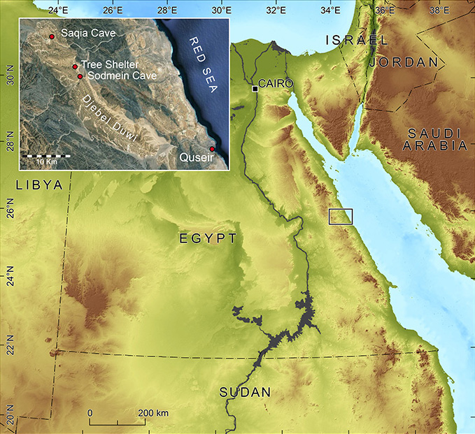
Location of the research area at Sodmein Cave in the Egyptian Eastern Desert (square). The detail map illustrates Djebel Duwi and the sites Sodmein Cave, Tree Shelter and Saqia Cave mentioned in the text.

Location and archaeological background
The amount of stratigraphic and secure dating evidence from Late Pleistocene archaeological sites of north-eastern Africa is limited and well-dated Middle Stone Age (MSA) sites remain a desideratum. One of the rare sites in this time range — beside the Haua Fteah in Libya (cf. Barker et al. 2010) — is the Sodmein Cave in Egypt.
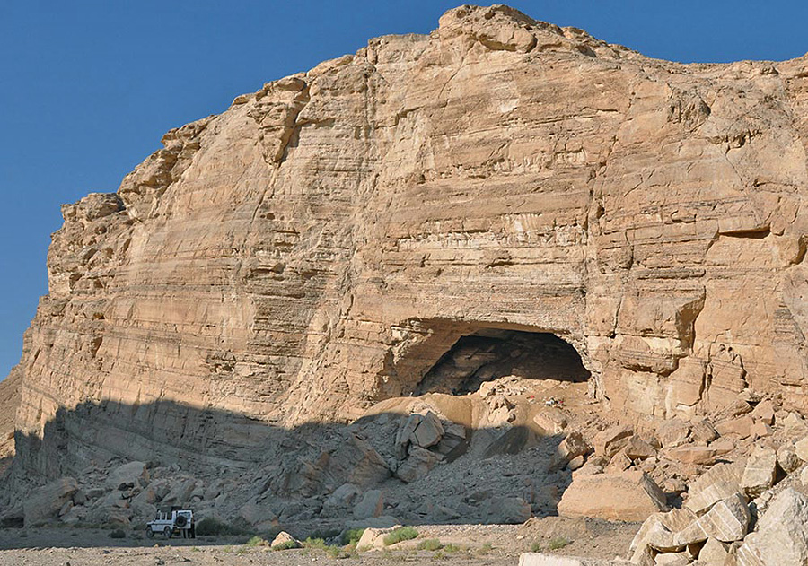
Sodmein is located about 40km north-north-west of the seaport Quseir in an isolated Tertiary limestone complex (Djebel Umm Hammad/Djebel Duwi) of the Red Sea Mountains (Figure 1; Vermeersch et al. 1994). This elongated Eocene limestone ridge runs almost parallel to the Red Sea graben structure and is surrounded as well as underlain by the basement rocks of the Red Sea Mountains. The cave is situated on the northern flank of the break-through of Wadi Sodmein through Djebel Duwi, around 17m above the present wadi floor (Figure 2). The cave was discovered in 1979 by M. Prickett during a survey but systematic scientific research did not begin until the 1990s by the Belgian Middle Egypt Prehistoric Project (BMEPP) of the University of Leuven (Vermeersch & Van Peer 2012). Since 2010, fieldwork has resumed in this area of the Eastern Desert through cooperation between the universities of Cologne and Leuven under the aegis of the CRC 806 'Our Way to Europe'.
Wadi Sodmein with the cave during excavation 2010; a car for scale in the lower left corner.

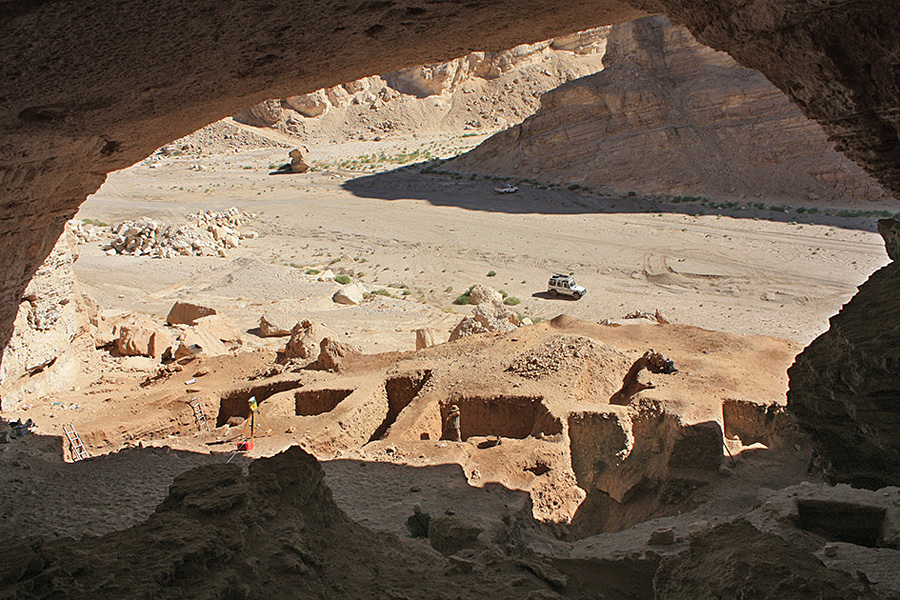
View from the back of Sodmein Cave over the archaeological excavation trenches.

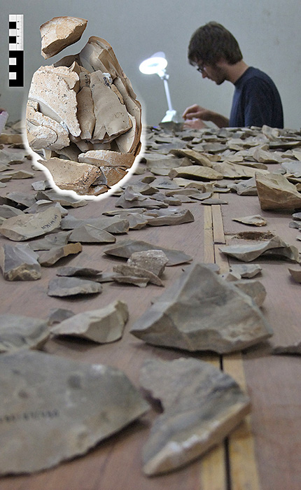
Refitting stone artefacts of layer J — attributed to the early Nubian Complex — from Sodmein Cave. In the upper left corner is a refit of a core reduction sequence from layer J.

In contrast to the isochronal sites from the Nile Valley, which are mostly raw material procurement sites (cf. Reference VermeerschVermeersch 2002), the Sodmein Cave can be interpreted as one of the rare living sites in this time frame in north-eastern Africa; it therefore comprises a key site for the reconstruction of Late Pleistocene human-nature interaction. The sequence — more than 4m, containing stratified human occupation debris — indicates that Sodmein was visited regularly by humans during the Pleistocene, as well as later during the Holocene (Figure 3). The lowest levels can be attributed to the early Nubian Complex, the regional manifestation of the MSA in north-eastern Africa (Figure 4). Current TL-dates of flint artefacts in a large fire pit — dug into the lowest layer — provide age estimates between 86±9 ka and 123±15 ka. They are, however, not concordant with the stratigraphic succession of firing events, indicating that the taphonomic history of this feature is complex and requires further research. About 10km to the north-west, another cave — referred to as Saqia — has been subject to geoarchaeological investigation (Figure 1). Here, speleothems were U/Th-dated by A. Mangini (University of Heidelberg) to the same time range as the lowest layer of Sodmein. For the first time, these results provide clear evidence for wetter conditions after MIS 5e in the Eastern Desert from a terrestrial archive. The new results reveal an apparently humid climate for north-eastern Africa between 81 and 87 ka, 94 and 107 ka, and 117 and 122 ka and supplement the palaeoenvironmental reconstruction of Sodmein Cave. The plant and faunal remains from the excavation — e.g. crocodile, large bovids (buffalo?) and kudu — also confirm wetter conditions than the current desert habitat (Moeyersons et al. 2002: 847).
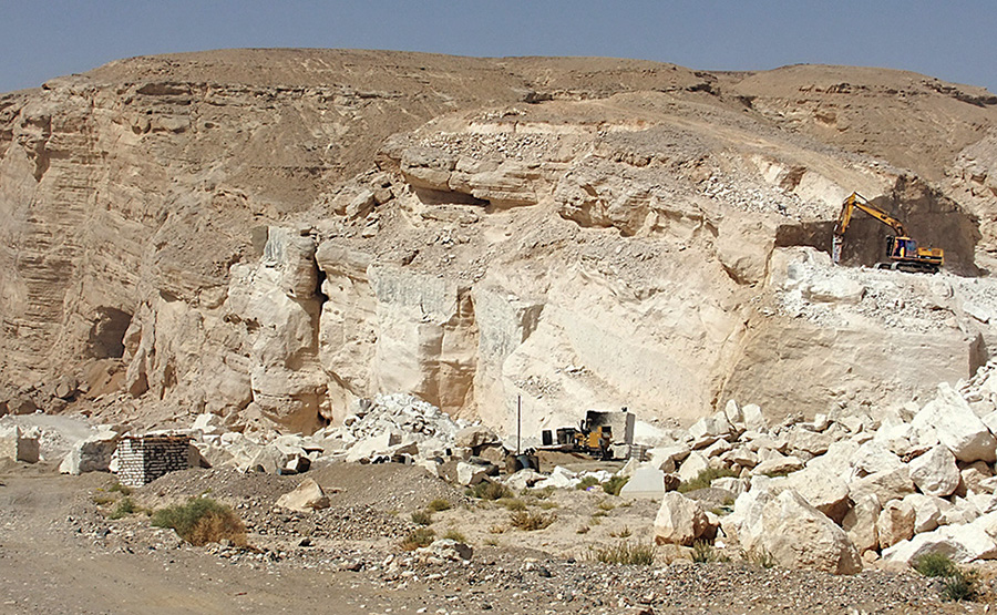
Current status of the limestone quarrying in Wadi Sodmein, the cave entrance is clearly visible on the left hand side only a few metres away from the mining activities. Limestone is fractured directly on the spot.

Modern threats
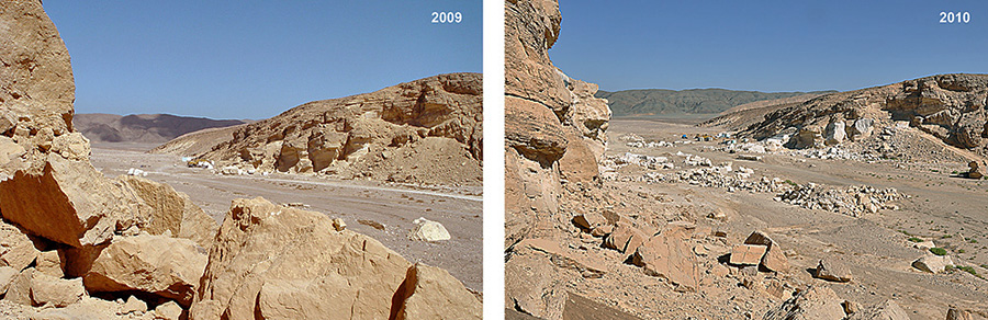
Upon reaching Sodmein in autumn 2009, after an absence of more than 10 years, it was alarming to observe the camp of a quarrying company in front of the cave. Limestone was being extracted by heavy machinery only a few metres north of the cave entrance (Figure 5). These activities threaten the cave and its archaeological deposits. Some cracks in the ceiling, which could lead to its collapse, have most likely resulted from vibration caused by mining. In 2009, only a small camp for the miners was observed (Figure 6, left); the situation had changed dramatically by autumn 2010 (Figure 6, right). Numerous rock spurs had been tested for future mining; loading ramps had been erected; rubbish as well as waste oil had been dumped; and vast quantities of limestone had been quarried (Figure 5) — all actions that endanger the site. This situation raises concerns that a unique Late Pleistocene site in north-eastern Africa could be destroyed, especially when viewed against the background of the demolition of the Tree Shelter and its associated archaeological site, only 4km further north in the same limestone ridge (Figure 1).
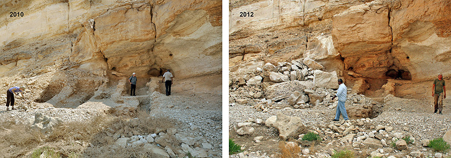
The Tree Shelter gained importance for understanding the primary introduction of small livestock into North Africa and was repeatedly occupied — most probably by short-term visits — from about 8000 cal BC to about 3700 cal BC (Reference VermeerschVermeersch 2008). It was among a select handful of archaeological sites from the Early and Middle Holocene in Egypt with a long-running stratigraphy and good preservation of organic material. Upon our arrival at the Tree Shelter in September 2010, the site was in the same condition as it had been left by the BMEPP team following excavation in 1996 (Figure 7, left). Only eighteen months later, the shelter had been destroyed, the trenches were buried by quarried limestone blocks and the surrounding area furrowed by bulldozer tracks (Figure 7, right).
View from Sodmein Cave towards the quarrying camp on the other side of the wadi. In 2009 only a small miners' camp is visible in the background as seen by a few white tents (left). One year later, loading ramps had been erected, the camp had become bigger — and also had a permanent solid house — and numerous projecting limestone banks had been exploited. In addition, quarried blocks were being stored in the wadi (right).

View of Tree Shelter in September 2010 (left), featuring the situation with the former excavation trenches of the BMEPP. The picture on the right documents the site in April 2012 and shows clearly the destruction of the shelter.

Perspectives?
The Sodmein Cave is an exceptional archaeological site in north-eastern Africa, with a unique stratigraphy of human occupation debris ranging from MIS 5e until the Holocene and hence its investigation promises further insights for the 'Out-of-Africa II' debate. Observing the current threats to the site presents cause for immense concern. Against the broader background of looting and the destruction of monuments which have occurred due to the political instability following the 2011 'Arab Spring', the situation is even more alarming. Apart from further archaeological research in Wadi Sodmein — to obtain as much information as possible before any further damage occurs — the protection of such archaeological sites should be a priority; especially for the rare and often remote but nonetheless important Pleistocene sites, which are out of sight and thus often out of mind.
With this article, we hope to have drawn attention to the Sodmein Cave site and the current threats to its survival. We hope also, through our ongoing research in close collaboration with the local authorities in Egypt, that the site can be preserved for future research.
Acknowledgements
This joint research project in the Sodmein area under the aegis of the Collaborative Research Centre (CRC 806) 'Our Way to Europe' is funded by the Deutsche Forschungsgemeinschaft (DFG). For permissions and support in the field we would like to thank the Egyptian Mineral Resources Authority (EMRA) and the Ministry of State for Antiquities (MSA) in Egypt.