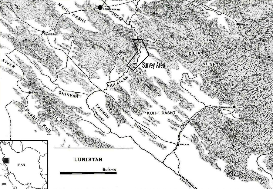
Location of the survey (after Reference MortensenMortensen 1993: fig. 6.1).

Presented to Professor Peder Mortensen
Introduction
Although Palaeolithic research in Iran, and especially in the Zagros region, began more than half a century ago, few open-air sites of this period have been discovered. Most Palaeolithic sites identified in the Central Zagros are caves and rockshelters and, if we base our understanding of the Palaeolithic on these sites alone, we risk gaining an outdated impression of prehistoric humans as cave-dwellers (Reference Bar-Yosef, Nash and PetragliaBar-Yosef 1993). Indeed the identification of open-air sites as places for activities by Palaeolithic communities is of great importance; these communities probably used open air sites for settlement, for making tools or for butchering hunted animals, when caves and rockshelters would have been less practical for these purposes. In short, there is no clear understanding yet in the Iranian Palaeolithic of human activities outside caves, which is what our survey, occasioned by the building of a dam due to flood the Kuran Buzan Valley in the Central Zagros, addresses.
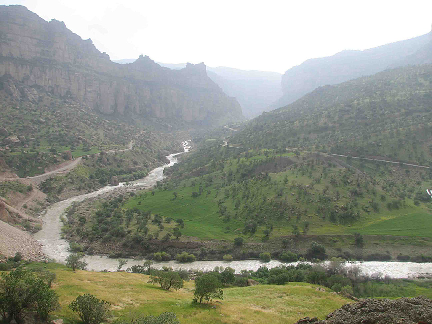
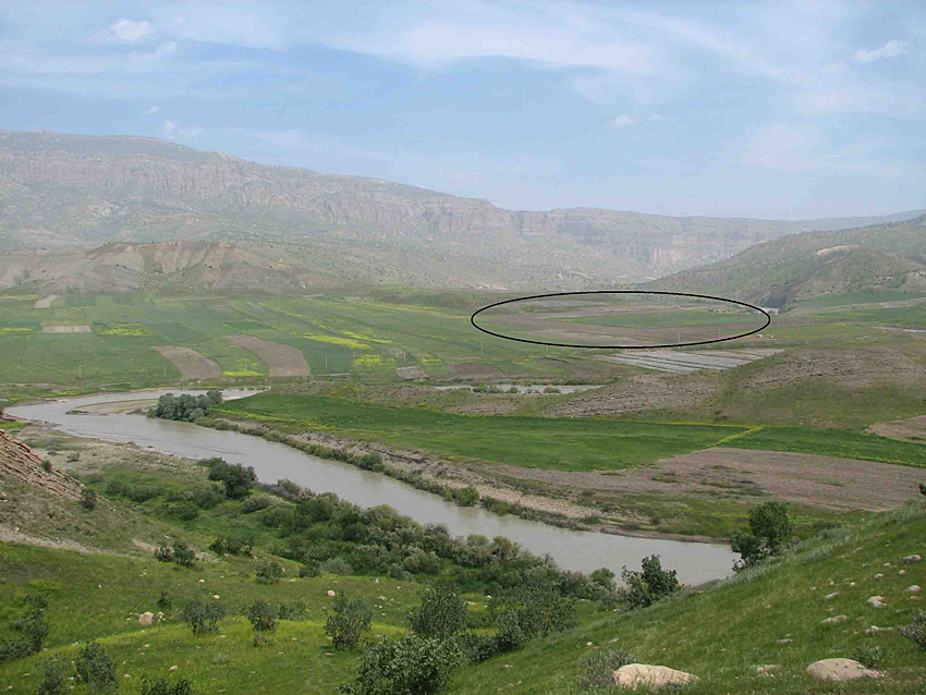
The landscape of the Kuran Buzan Valley.

The Kuran Buzan Valley
The Kuran Buzan includes parts of Kuhdasht town in the west of the province of Luristan, and Hulailan to the north-east of Shirvan-Chardavel in the province of Ilam (Figure 1). The area of survey extends over 71km² and includes valleys and hills overlooking the river Saimareh.
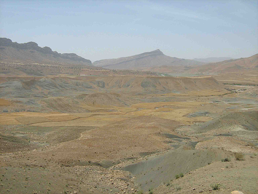
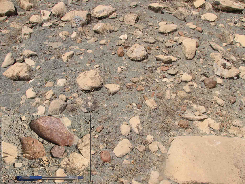
Kuran Buzan is a long and narrow valley (Figure 2), through which the river Saimareh flows from the north-west. Flood channels, streams and seasonal springs are plentiful. The valley is located in the mountainous terrain of the Kuran Buzan heights in the east, the Sheikh Mountain in the south, and the Mahmeh Mountain in the north. A location known as the Shirez Strait marks the entry of the river Saimareh into the valley and a narrow strait, Tang-e Garmeh and Humamalan, exists where the Kuran Buzan heights meet the Sheykh Mountain. Small alluvial terraces run along the edges of the river in the central part of the valley. Both sides of the valley are covered by hillocks. The surface is mostly stony with limestone appearing as outcrops and loose rocks (Figure 3). There are abundant lumps of chert (Figure 4) across most of the hillocks and slopes as well as numerous angular stones. The forest coverage includes oak and ash.
The floor of the Kuran Buzan Valley.

Chert on site H 102.

Background
The Central Zagros offers a combination of excellent conditions: a rich environment, water resources, abundant chert, and the fact that much research has been conducted in this his area over the past decades. Yet Palaeolithic open-air sites were still largely missing: we believe that this is due to inadequate survey strategies, not to a real absence of open-air sites. Indeed it is only recently, during an intensive survey in the Kuran Buzan Valley (Reference AlibaigiAlibaigi 2010), that we managed to identify open-air sites.
During the twentieth century regions near our survey area, including Hulailan, Boluran and the Tarhan valleys, were studied by British archaeologists under the supervision of Sir Aurel Stein (Reference SteinStein 1940) and Clare Goff (Reference GoffGoff 1971). A Danish expedition, headed by Jorgen Meldgaard (Meldgaard et al. 1964), Henrik Thrane and Peder Mortensen (Reference ThraneThrane 1964, 1970, Reference Thrane2001; Reference Mortensen and BagherzadehMortensen 1974a & Reference Mortensen and Bagherzadehb, 1975, Reference Mortensen and Bagherzadeh1976, Reference Mortensen1979 & Reference Mortensen1993) worked in the Hulailan before the Islamic Revolution. Mortensen conducted a thorough survey during two seasons, and some eastern parts were surveyed and excavated in the 1970s by an expedition from Cambridge University (Mc Burney 1970; Bewley 1984).
The 2010 survey
View of site H 105.

The archaeological survey of the Kuran Buzan was directed by Sajjad Alibaigi in 2010 under the aegis of the Iranian Centre for Archaeological Research. The aim was to identify archaeological sites located within the boundaries of a basin that will be flooded by the construction of a dam. Because the Kuran Buzan Valley is located amidst three archaeologically important areas, the Hulailan in the west, Kuhdasht in the east and Kermanshah (Harsin) in the north — all of which have revealed material from the Palaeolithic to the present — and because of its topography — meaning that some remote places could be missed — the area was surveyed intensively on foot. While this survey was mainly an inventory survey, it was also an opportunity for research. Accordingly the whole area was graded into zones according to soil cover, heights and type of relief.
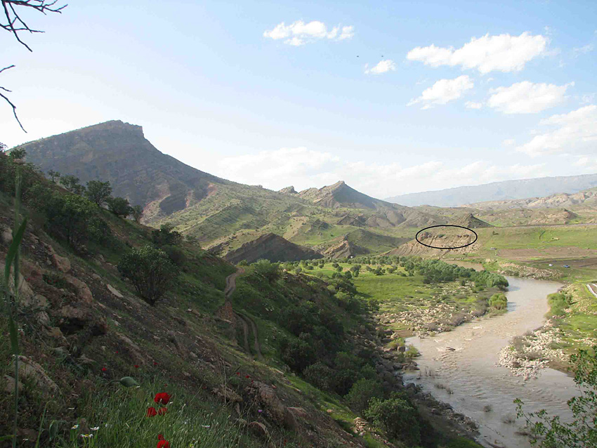
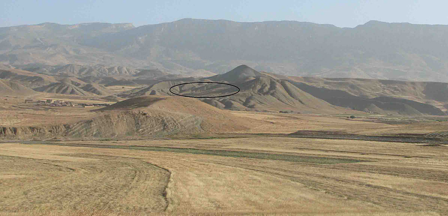
After 35 days of intensive fieldwalking by a team of eight in an area c. 71km² in extent, we identified a significant number of sites from the oldest human settlement to the present, including deserted villages. The site total is 122, scattered in different locations but especially present on heights and slopes. Most sites appear to belong to the Palaeolithic: of the 122 sites, 110 sites were classified as Palaeolithic (including open-air sites, see Figures 5 & 6), 2 sites as Neolithic, 1 site as Chalcolithic; 6 sites belong to the historical period and 3 to the Islamic era.
View of site H 065.

The Palaeolithic sites
The remains of human activity from the Palaeolithic — 110 sites with a scattering of Palaeolithic tools — were found over most of the survey area. These sites are located at heights of 9501150m asl, mostly on natural mounds, hillocks and river terraces. There was no evidence in our survey of activity in the caves and shelters of the north of the valley. The hillocks and terraces facing the river were surprisingly rich, most probably because of the ample source of raw materials and animals for hunting. Wherever chert was available, stone tools were found; indeed the scattering of Palaeolithic tools was almost entirely confined to places with chert. Stone tools were however also found in 20 other locations, perhaps indicating hunting among hillocks, which could have provided suitable hunting grounds (Mortensen 1974).
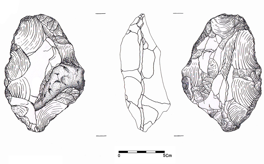
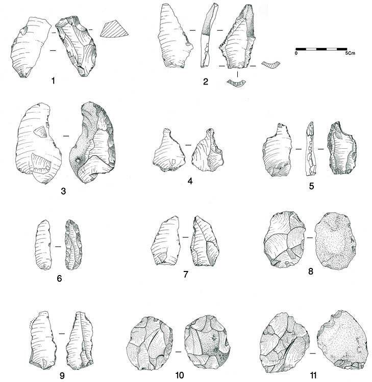
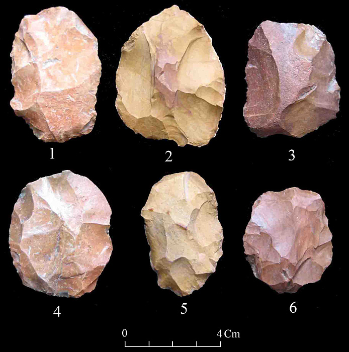
The sites appear to belong to the Lower (3 sites) and Middle Palaeolithic (107 sites) and so far we have not identified the Upper Palaeolithic or Epipalaeolithic. A tool found on site H 102, 500m south of the village of Koore Dasht-e Sofla is probably an Acheulian handaxe (Figure 7). Most of the Middle Palaeolithic sites produced cores, points and Levalloisian flakes (Figures 8 & 9). On some sites there were no noticeable tools and the artefacts restricted to a few cores and simpler flakes.
An Acheulian handaxe (?) from Koreh Dasht-e Sofla (site H 102).

Middle Palaeolithic artefacts: 1) sidescraper (H 102); 2) Levallois point (H 082); 3) single side scraper (H 042); 4 & 5) borers (H 106, H 103); 6) convergent scraper (H 102) ; 7 & 9) Levallois points (H 001, H 112) ; 8, 10 & 11) Levallois cores (H 099, H 101, H 042).

Levallois cores : 1 & 3) H 099 ; 2; H 082; 4) H 101 ; 5) H 105 ; 6) H 119.

The site and landscape of Gashur (site H 075).

It seems likely that our sites were hunting or fishing stations or places to make stone tools. This is suggested by the presence of hunting tools and the absence of flakes and cores on some sites and the abundance of flakes and cores on others. Most sites produced more than 10 stone tools; those with fewer than 10 were recorded as single findings (Reference AlibaigiAlibaigi 2010). The smallest site is 15 x 15m and the largest almost 50ha. Gashor (H 075), the largest, is located on an old terrace facing the river Saimareh in the north of the valley near the village of Piaz Abad (Figure 10). This site yielded almost 50 000 pieces of stone tools including 420 pieces thought to belong to the Lower Palaeolithic.
Most artefacts were made from red, light brown and sometimes grey chert, most of which was of medium to high quality. Given the type of cortex and the chert outcrops available, almost all tools were made from medium-sized or small rubble. This suggests that the small size of the tools in the Kuran Buzan Valley was not due to repeated use or exploitation but to a lack of large pieces of chert.
At present we cannot argue whether any given findspot is to be considered as a site in itself or whether we should regard the whole valley as a single Palaeolithic landscape. But our understanding of the nature of each location led us to record any independently defined area as a distinct unit. This approach resulted in the identification of sites with different characteristics in different parts of the valley.
Conclusion
Understanding the area's geology and topography, as well as benefiting from the results of research by Mortensen in the Hulailan, enabled us to identify Palaeolithic sites in an intensive survey of an area to be flooded by the construction of a dam. Indications of Palaeolithic human activity were found over most of the area surveyed. A preliminary analysis of the stone tools shows that there are several types of sites in the valley, probably including tool-making places, hunting sites, fishing stations and a combination of these. The Kuran Buzan sites add significantly to the evidence from caves and from the areas of Hulailan, Kuhdasht and Harsin and reveal that the Central Zagros is still capable of contributing fresh material to Palaeolithic research.
Acknowledgments
We thank Mr Arash Lashkari, the respected head of the Iranian Centre for Archaeological Research, who made the preparations for the survey, Dr Fereidoun Biglari director of the Palaeolithic Research Department of the National Museum of Iran, for his valuable comments and Ata Hassan Pour at the Cultural Heritage Office of Luristan for his cooperation. We also thank Dr Madeleine Hummler and Poorya Khadish for editorial help and Nazli Niazi and Golnaz Ahadi for drawings.