The Río Bec region may be one of the most enigmatic of ancient Mesoamerica. Located in a remote area, transitional between the northern and the central Maya lowlands, sites here were discovered at the end of the nineteenth century, then lost and rediscovered much later. Adding to its “mystery,” the region displays an alluring monumental architecture that differs from the central lowland template to the south. Even the casual observer of ancient Maya architecture can cite the major hallmarks of the Río Bec architectural style: profusely decorated building facades, non-functional, solid twin towers, false staircases, high-relief stucco decoration, and round corners. The towers narrow at the top to give an illusion of height and appear to have stairs, rooms, and doorways that appear as entrances to nonexistent rooms. The style compares well with large buildings of the Chenes and Puuc styles, while featuring some unique traits, such as the so-called towers or false temples. Finally, these inaccessible ruins were (and still are) relatively well-preserved, with high-standing walls and even some well-preserved vaulted roofs. The research of the French project reported here concentrated on the archaeological zone rather than “the site” of Río Bec, starting with the premise that no truly nucleated center existed in the vicinity of the re-discovered groups. If no nucleated center existed, how are we to understand these extraordinary ruins dispersed in the rain forest?
To introduce the papers in this Special Section, we shall first summarize the history of past research at Río Bec, and then outline the research project goals, research design, and development. Some of the results obtained may appear unexpected, or at least not perfectly in line with consensual knowledge about Classic Maya societies. We also present and discuss interpretations of Río Bec social and political dynamics from a.d. 550 to 950/1000, clarifying some of the basic concepts used in the present papers. Finally, we provide an overview of the contribution that each of the following papers brings to the reconstruction of this remarkably creative and innovative Classic Maya society that thrived far from the lowland fertile, inundated depressions and river valleys of the central lowlands.
HISTORY OF RESEARCH AT RíO BEC
The first well-preserved Río Bec building brought to scholarly attention—later referred to as Group A—was discovered sometime around 1895 by the German geographer Karl Sapper, who published a drawing of its ground plan (Reference Sapper1895a, Reference Sapper1895b, Reference Sapper1897). The French explorer Maurice de Périgny came next, casually visiting the same group in 1906–1907. He reported what he referred to as “Edifice A” (Reference Périgny1907, Reference Périgny1908, Reference Périgny1909aReference Périgny1909b; see also Taladoire Reference Taladoire1995) and transmitted his field notes to Raymond E. Merwin, who reached the site five years later, during the tenth expedition of the Peabody Museum of Harvard University of 1911–1912. With his assistant Clarence L. Hay, Merwin carried out the first intensive research in the region, describing and mapping seven architectural groups for his doctoral dissertation (Groups A, B, C, D, E, F, and G), as well as other, more distant sites, including La Tortuga, and Ceibarico or El Porvenir (Merwin Reference Merwin1913). Unfortunately, Merwin contracted an undiagnosed tropical disease in 1914–1915 that prevented him from returning to the Maya area and which eventually led to his death in 1928.
Río Bec then drew the attention of archaeologists of the Carnegie Institution of Washington (CIW) who undertook a first visit of the area in 1933, when Karl Ruppert and John H. Denison, Jr. located a large architectural group they labeled Group I (the roman numeral) which included Merwin's Group F. The next CIW expedition took place the following year, leading to the definition of four new architectural groups, Groups II to V, scattered on the periphery of Group I (Ruppert and Denison Reference Ruppert and Denison1943; see also Black [Reference Black1990] for further comments on CIW archaeology and its legacy in the Maya area). Ruppert and Denison failed to relocate the groups described by Merwin. In a separate expedition, J. Eric S. Thompson (Reference Thompson1936) surveyed the Río Bec area on horseback in 1936, locating at least three more groups, two of them located on the eastern fringe of Merwin's groups. Thompson did not attempt to relocate Merwin's groups, although he unknowingly described and mapped Merwin's Group E. He also discovered Las Escobas (Yaxek-Las Escobas, southeast of Merwin's groups).
Later, in separate publications, Alberto Ruz Lhuillier (Reference Ruz Lhuillier1945) and Thompson (Reference Thompson1945) both postulated the existence of a specific Río Bec province defined by the distinctive architectural and iconographic style reported by Merwin and the CIW expedition, echoing what Périgny had intuited earlier when he had remarked on how much these buildings differed from their northern and southern counterparts. But in the meantime and in spite of Thompson's efforts, the location of all groups was lost and Río Bec remained hidden deep in the dense tropical forest in a zone then largely unoccupied. In Reference Proskouriakoff1946, Tatiana Proskouriakoff published an extraordinary reconstruction drawing of the main structure of Xpujil with its three towers, giving more visibility to what was already defined as “Río Bec architecture” (Pollock Reference Pollock1967).
During the late 1960s, on the basis of previous work and his own excavations at Becan, David F. Potter (Reference Potter1976, Reference Potter1977) redefined the cultural province of Río Bec-Chenes of central Yucatan, while Jack D. Eaton (Reference Eaton1975a) excavated the neighboring site of Chicanna, and carried out a wide-scale survey around Becan and in the entire Río Bec region locating some new groups (unpublished). Potter, and later R. E. W. Adams (Reference Adams and Ashmore1981:214–216) published accounts of all work conducted in the wider Río Bec region at a time when the Périgny-Merwin and CIW groups still remained unlocated. As Adams (Reference Adams and Ashmore1981: 214) put it, during the 1970s, only 40% of central Yucatan had been surveyed on a preliminary basis.
In the early 1970s the trans-peninsular highway was constructed from Escárcega to Chetumal across the forested area, allowing German artist Andy Seuffert to attempt to relocate Río Bec Group B which had remained the best known, even though Merwin's and Hay's stunning photographs were still unpublished (Pollock Reference Pollock and Willey1965:Figure 36). Seuffert rediscovered Group B during a second visit, in July 1973 (Seuffert Reference Seuffert1974). This same year, the Río Bec Ecological Project was organized, headed by Richard E. W. Adams and supported by the National Geographic Society. Adams (Reference Adams1975, Reference Adams and Adams1977, Reference Adams and Ashmore1981; Adams and Jones Reference Adams and Jones1981, Adams and Adams Reference Adams and Adams2003) launched a new settlement pattern research program, while Joseph W. Ball (Reference Ball1977) established the regional ceramic sequence. Geographer B. L. Turner II recorded rural remains and terracing in the first intensive study of prehispanic agriculture in central Yucatan (Reference Turner II1974, Reference Turner II1983; see also Eaton Reference Eaton1975b), although, as Turner (Reference Turner II1974:123) indicated, Thomas Gann, C. L. Lundell, Oliver G. Ricketson, Jr., and Ruppert and Denison had suggested the concept and reported relic terraces as early as the 1930s.
As director of the Río Bec-Becan Archaeological Expedition of 1976, sponsored by the University of the Americas, Prentice M. Thomas, Jr. (Reference Thomas1981), studied Río Bec-Becan settlement patterns and carefully excavated and consolidated the best known building in Group B, Structure 6N1. This project also recorded and test-pitted several mounds in the surrounding region (Thomas and Campbell Reference Thomas and Campbell2009; see also Freer Reference Freer1976, Reference Freer1986, Reference Freer2006), thus confirming the existence of minor settlements in addition to the already well-known monumental groups. Additional excavations and analyses at Becan were conducted by María Teresa García (Reference García1982), Lewis C. Messenger, Jr. (Reference Messenger1975), and Marc Thompson (Reference Thompson1981).
Archaeologists returned to the Río Bec region in the early 1980s when a team from the Instituto Nacional de Antropología e Historia (INAH) directed by Ramón Carrasco Vargas and his colleagues discovered seven new architectural groups (Groups J, K, L, M, N, R, and X) scattered among Merwin's groups. They elaborated sketch maps of most large buildings, and conducted a test pit program allowing for a preliminary ceramic sequence (Carrasco Vargas et al. Reference Carrasco Vargas, Boucher and Peña Castillo1986; Peña Castillo Reference Peña Castillo1998; Schmidt Reference Schmidt1981). As Carrasco Vargas (Reference Carrasco Vargas1989, Reference Carrasco Vargas1994) also mapped the surroundings of Chicanna, locating a dense network of terraces and ridges, he was able to offer valuable comparisons with the vicinity of Río Bec Group B. Ricardo Bueno Cano (Reference Bueno Cano1989, Reference Bueno Cano1994, Reference Bueno Cano1999; Bueno Cano et al. Reference Bueno Cano, Benítez, Ramírez and Zaragoza Balderas1992) directed another INAH project and published insightful observations on Río Bec architecture and occupation (see also Peña Castillo Reference Peña Castillo1987), while Paul Gendrop (Reference Gendrop1983, Reference Gendrop1987) and George Andrews (Reference Andrews1999) provided precise definitions, descriptions, and reconstruction drawings of many Río Bec buildings (see also Hohmann Reference Hohmann1998). In the meantime, the wider Río Bec region had remained partly unsurveyed. From 1996 to 2000, as part of the Balamku project, Philippe Nondédéo (Reference Nondédéo2003, 2005) carried out an extensive survey of a 400 km² region west of Manos Rojas. Jack Sulak (Reference Sulak2001), Ivan Šprajc (Reference Šprajc2004), and others made regular visits to Río Bec during this period (Mexicon 1990a, 1990b, 1997a, 1997b).
RÍO BEC PROJECT GOALS AND RESEARCH DESIGN
Although discontinuous, these numerous researches in the Río Bec region made clear three outstanding features shown by the surveyed archaeological remains. First, the settlement appears to be dispersed without any truly nucleated center, or “sites of any magnitude,” in the phrase of Brown and Witschey (Reference Brown and Witschey2003:1623), who cast doubt on such absence. Second, the architecture seems to be as monumental as in many other lowland Maya nucleated centers—although massive pyramids are conspicuously absent—evidence that calls into question the private or public functions of the corresponding buildings. Third, the density of remains between the monumental groups is relatively great, including a large number of terraces and long, linear ridges, both with agricultural functions (Carrasco Vargas et al. Reference Carrasco Vargas, Boucher and Peña Castillo1986; Peña Castillo Reference Peña Castillo1987; Pollock Reference Pollock1967; Thomas Reference Thomas1981).
The first goal of the new research project, Société et économie de Río Bec à son apogée, organized in 2002 and directed by Dominique Michelet and M. Charlotte Arnaud, was to confirm the absence of nucleated centers, and to evaluate the spatial distances separating the largest groups, a parameter also discussed, among others, by Carrasco Vargas and Boucher (Reference Carrasco Vargas, Boucher, Andrews and Gendrop1985:26). Then, the functional issues raised by the Río Bec monumental architecture were to be addressed, and the correlation assessed between the elaborate buildings and their associated agricultural features and outlying minor groups. In an unpublished report not available in 2002, on the basis of his excavations in 1976, Thomas had suggested that Building B was a high-status residence rather than a temple (Thomas and Campbell Reference Thomas and Campbell2009:139). Adams (Reference Adams and Ashmore1981:217) had correctly inferred that the Río Bec groups had been “built for private use by the ruling classes.” Adams had proposed a sociopolitical interpretation of the Río Bec (and Chenes) courtyard groups that supported his feudal model of Maya society (Adams and Smith Reference Adams, Smith and Ashmore1981). Later, he dropped the controversial “feudal” adjective and labeled the Terminal Classic courtyard groups “aristocratic country estates” (Adams and Adams Reference Adams and Adams2003:148). It is beyond the scope of this Introduction to discuss these models, but it is important here to clarify the premise of one of Adams' most significant contributions, his efforts to obtain a rank ordering of these courtyard groups (Adams and Adams Reference Adams and Adams2003; Adams and Jones Reference Adams and Jones1981; see also Brown and Whitschey 2003:1623). With somewhat different conceptual tools, we followed this methodological move, although consciously ranking “residential compounds” (most of them devoid of courtyards), rather than “sites” or “civic-religious centers” (Nondédéo Reference Nondédéo and Michelet2004).
Owing not only to Adams’ published results, but also to previous work on small sites like Xculoc and Xcochkax, Campeche, in the northern lowland Puuc zone by Michelet et al. (Reference Michelet, Becquelin and Arnauld2000), project members were prepared to apprehend the kind of archaeological remains left by a rank society, characterized as more rural than urban, with a spatially and politically atomized structure. Typology and rank-ordering of the studied Puuc buildings had led the project to conceptualize a specific type of building as “a seat of power” (Michelet et al. Reference Michelet, Becquelin and Arnauld2000:489–490), on the basis of its iconographic decoration, wider interior space, and central position within groups. The corresponding buildings were interpreted as combining residential and political functions, acknowledging that political roles in the Puuc region were displayed in domestic venues of a sort below, or parallel to, what is termed a “royal palace” (see also Michelet and Becquelin Reference Michelet, Becquelin, Torrecilla, Villarejo and Fernández Marquínez1995).
It seemed reasonable to suppose that the local monumental buildings conspicuously adorned with towers and/or zoomorphic portals had been seats of power (and the residences) of local rulers. Yet, these buildings were larger than the Puuc ones known, and paradoxically separated by distances even shorter than in the Puuc region (100–800 m versus 1–2 km), which brings into question their “political” nature. It became clear that monumentality and spatial distance between groups had to be assessed and interpreted only after their ranking order had been established, which meant that, before making the assessment, the groups had to be precisely dated. By the same token, the density of remains around each group had to be evaluated, as the degree to which Río Bec shows a fractal structure, that is “clusters of clusters of clusters ad infinitum” as hypothesized by Brown and Whitschey (2003:1624; see also Lemonnier Reference Lemonnier2009), a largely uncontrolled parameter of social relevance.
Thus, as formulated in 2002, the aims of the Société et économie de Río Bec à son apogée project were first chronological, including the relative dating of both large and small groups, the dating of the Río Bec style, and the construction of a culture-historical sequence for the survey zone. Other goals were sociopolitical in nature in order to define Río Bec social units in spatial and architectural terms, their mutual relationships and their precise ranking at the moment of the cultural apogee. Functions and status had to be assigned to the top-ranked buildings, and funerary treatment of the associated burials had to be precisely studied. The project was also assigned the study of hydrological and climatic parameters of the regional ecology, as well as the analysis of land use and intensive agricultural techniques anciently developed by the Classic period Río Bec farmers. Given the touristic nature of the “site” which was already visited on a regular basis when the project began excavating, a clear cultural heritage concern also existed as it sought to consolidate as many buildings as possible after their complete exposure by means of stratigraphic excavations of their interior and exterior floors, including architectural fill. The sub-projects that make up the complete program are given in Table 1.
Research design, space, and time scales of the Société et économie de Río Bec à son apogee project

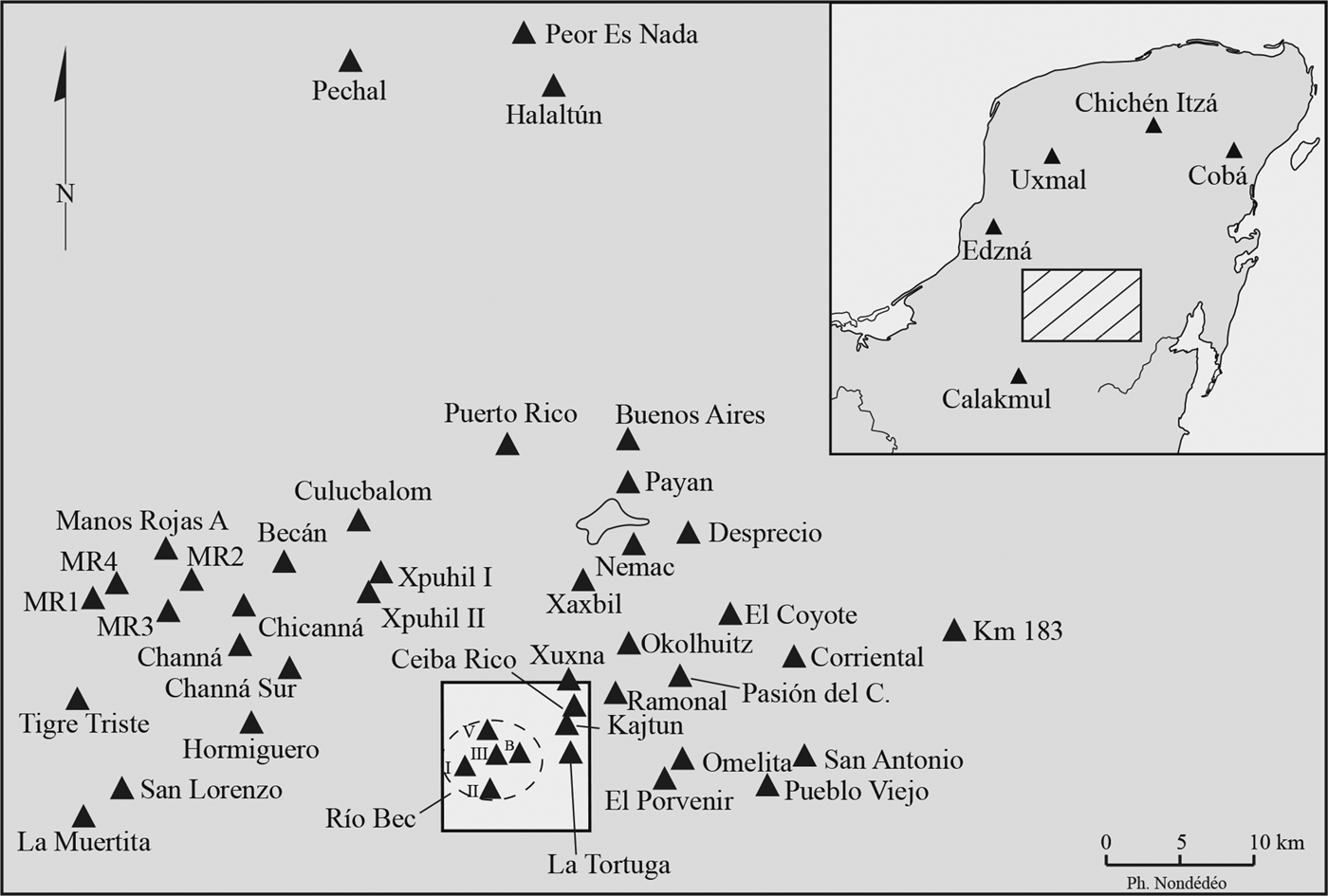
The regional survey zone, a 10 × 10 km square or 100 km2 (Figure 1), was defined around the cluster of the 23 Río Bec groups known in 2002 in order to facilitate an understanding of the general political organization of settlement, without any illusion of discovering the mythical nucleated center. Even this “micro-region” proved too small for this objective, since some of the settlement concentrations formed late in the Late Classic period are located 1.5 km east of the survey zone, El Porvenir and Omelita (discovered in 2008). Within our survey zone, the only group qualifying for the fractal definition of “a cluster of clusters,” Kajtun, at the northeast margin, was largely abandoned after the Early Classic as was Group II to the southwest, a typical Peten-style public plaza with a ballcourt, abandoned at the end of the Early Classic period and apparently not replaced until the Terminal Classic by another public plaza with ballcourt (which might be earlier), Group V, to the northwest. Neither Group II nor Group V ever concentrated any settlement in its vicinity. No group of any size would correspond to a political center during the Late to Terminal Classic, the time of the Río Bec apogee. Instead of concentrating most excavations into those three so-called political groups, the project decided to dedicate efforts to a few residential groups truly representative of the more than 50 already discovered monumental groups.
Map of the Río Bec region showing the location of the main groups and sites, as well as the project micro-region (white square, 10 × 10 km). GPS coordinates of Río Bec Group B are 18°22.510, 89°21.524.

It seemed likely that the reconstruction of the social dynamics of residential groups through the Classic period would offer better insights into the local political organization, rather than taking the apparent political sequence of only three groups as accounting for the development of so many conspicuous groups. This option was also due to the results obtained in 2002–2003 from a larger-scale, systematic survey carried out in a “nuclear zone” 159 ha in area that includes most of the recorded architectural groups (A to L; concentrated in a rectangular area measuring 1 × 1.5 km). More than a hundred units of the common, medium to small-sized household type were located, along with hundreds of terraces, ridges, and stone piles. Further studies of the political groups were postponed for a second stage of the Río Bec project. Provisionally it can be said that the Río Bec rulers with residence at Group V, the only group with an occupation coeval with the dates inscribed on its stelae, were “weak kings” inasmuch as they were unable to foster the emergence of an attractive and stable primary center around their residence. Those who maintained prosperity and creativeness were the Río Bec social groups that were able to build their own great house, in some way their miniature center.
This orientation of the project toward social rather than political issues was not due to a local absence of stelae or epigraphic material. Associated with Kajtun, Group II and Group V are 18 stelae, six of them with typical Late Classic period ruler iconography, while seven include inscriptions with calendar dates ranging from a.d. 475 to 869. Alfonso Lacadena's (Reference Lacadena2007; Arnauld and Lacadena Reference Arnauld and Lacadena2004; Nondédéo and Lacadena Reference Nondédéo and Lacadena2004) work on this material is referred to in several of the following papers. Lacadena suggests that rulership at Río Bec (Bolonil) entailed a peculiar system of territorial and temporal dominance, probably distinct from what is consensually known for the central lowlands. The basic principle would have been that if the Río Bec Classic society was formally ranked (instead of stratified in classes), some person or institution at the apex had to assign those ranks to the “noble farmers” and their houses (Lacadena Reference Lacadena2007). The issue remains open, and for the meantime, Río Bec politics cannot be defined much beyond the idea of interactions among powerful social groups seeking to achieve dominance over the community, an entity that remains abstract for us, but perhaps also for the ancient Río Bec Mayas.
A few additional comments are necessary concerning some concepts used in the social analyses of the following papers. Among other benefits, insisting on ranks rather than on stratified classes helps to nuance the distinction between “commoners” and “elite.” Although both terms may occur used in a loose sense in the following papers, the typologies and rank ordering built out of fieldwork data demonstrate that, by a.d. 800–900 most Río Bec people moved through many intermediate positions as they worked hard for the social promotion of their group. The concept of “nouveau riche” may apply, defined according to the Oxford English Dictionary as, “people who have recently acquired wealth, typically those perceived as ostentatious or lacking in good taste.” Social ranking, as reflected in the extraordinary diversity of the Río Bec residences, soon led the project to look for the archaeological correlates of one specific social model, société à maisons (Lévi-Strauss Reference Lévi-Strauss and Modelski1982; see also Gillespie Reference Gillespie2000), often referred to in English as the “house model.” The Río Bec architectural style is all about houses, and the empirical opportunity to apply this now well-known model was not to be lost.
The house model proves efficient in helping to understand many details of Río Bec residential architecture and the almost continuous construction activity from a.d. 625 to 850, and also in reconstructing the extreme ranking and dynamics of the local groups such as growth by natural increase and incorporation of neighbors, appropriation of land, intensification of land use through terracing, stable cooperation among neighbors, and competition among distant groups. It leads to a definition of the first non-epigraphic, archaeological approach to alliance (or double alliance; for example, endogamous/exogamous, local/distant). It also helps to pinpoint the limits of these dynamics; for example, centrifugal trends interpreted at the micro-regional scale as the result of certain houses splitting and expelling members—when and where their ambition for growth in number and land was constrained by lack of space (see Wilk Reference Wilk, Wilk and Ashmore1988:146). In other words, the house model in the Río Bec archaeological context elucidates material and symbolic correlates for what became extraordinary architectural and agricultural investments in properties (estates), each transmitted by a focal residence “containing” an increasing number of coresidents bound by kinship and other ties. These people served the moral person of their house, and so deserved its benefits.
RIO BEC ARCHITECTURE AND SOCIAL RECONSTRUCTION
Three main factors make the case study of Río Bec compelling and fascinating: (a) local architecture, although truly monumental, does not refer to political dynasties, (b) settlement and household patterns translate into less vertical (temporal) continuity than horizontal (spatial) interaction, and (c) the economic prosperity has more to do with localized, intensive agriculture of the infield type than with crafts and long-distance trade. Temples consist of false buildings (towers) subordinated to the decoration of residential façades designed for the social reception of living humans, not gods. In few words, Río Bec must be seen as a society of prosperous, ambitious farmers obsessed by the inward ideology of their own social group. Yet, the nearby Classic Maya center of Becan, located 20 km to the northwest, has the same architectural style associated with a tightly nucleated settlement of palaces hierarchically arranged around closed patios, with tall, Preclassic-Early Classic pyramidal platforms crowned by dynastic temples, and much material evidence of long-distance trade (Ball Reference Ball1977; Bueno Cano Reference Bueno Cano1999; Nondédéo et al. Reference Nondédéo, Patrois, Lacadena, Arnauld, Taladoire and Michelet2011). It is tempting to think of the dispersed Río Bec buildings as “country estates” for the aristocracy of Becan, that is, as the result of a basically exogenous process. But, beyond its anachronism, this interpretation would explain neither the large number of monumental groups (Figure 1), nor the chronology of their development relative to the Becan sequence. At that time, an authentic phenomenon emerged in the region transitional between the southern-central and the northern lowlands. In any case, we should not neglect the fact that, during most of the Classic period, the Río Bec micro-region was constrained by powerful kingdoms (Figure 2), not only Becan to the north, but also Calakmul and Oxpemul to the west, El Palmar to the south, and Kohunlich and Dzibanche to the east, not to mention closer secondary entities (Šprajc Reference Šprajc2008). The Río Bec groups’ prosperity and growth may have depended partly on their neighbors’ sociopolitical dynamics, although the archaeological evidence for interaction obtained at Río Bec is at present limited.
Map of the central Maya lowlands showing the spatial extension of the Río Bec style in Terminal Classic times (in gray) (modified from Nondédéo et al. Reference Nondédéo, Patrois, Lacadena, Arnauld, Taladoire and Michelet2011).

The central interpretation emerging from the Société et économie de Río Bec à son apogée project posits that locally prosperous and ambitious social groups actively resisted settlement nucleation and political centralization, as they gave priority to their “local business” combining intensive agriculture and prestigious residences. These actions were fostered by emulation of elites of large neighboring cities, but were also made possible by favorable climatic conditions during the Late Classic period. The possibility that specialized crop production sustained local prosperity cannot be discarded, but no clear evidence of this has been recovered. Reluctant to join regional overlords in the court life of some distant nucleated center, local farmers could not, or would not, allow the rising power of one of their peers that would have attracted other houses, fostered nucleation, and created court life locally. Their exclusive success in building large prestigious houses could be seen as an extreme in terms of exclusionary versus corporate strategies (Blanton et al. Reference Blanton, Feinman, Kowalewski and Peregrine1996). Agrarian factors, including strategies for acquiring and controlling increasingly larger estates around residences in the midst of a tight land tenure system, undoubtedly hindered nucleation trends. Yet, as mentioned, two late concentrations are identified around El Porvenir and Omelita, and around Group I, on the margins of the surveyed micro-region. They emerged probably a couple of centuries before the final abandonment. This precludes the idea that the Río Bec house society that we posit could have resulted from the decline of some local state; instead, it produced the slow, at last interrupted, process of pre-state institutional formation (for the relation of house societies with state formation, see Bourdieu [Reference Bourdieu1997, Reference Bourdieu2012]). All data and interpretations in the following papers reflect a marked involution of the Río Bec social groups, obsessed by their rank, prestige and growth, with little energy or resources left to care for the development of superior institutions. In this respect, Río Bec offers Mayanist anthropologists the opportunity to study the initial steps of state formation in the lowlands.
The Terminal Classic period saw a regional diffusion process of the Río Bec architectural style over the central lowlands, from Kohunlich in the east to El Tigre in the west, from Becan in the north to Naachtun in the south (Benavides Castillo Reference Benavides Castillo2007; Nalda and Balanzario Reference Nalda and Balanzario2007; Nondédéo Reference Nondédéo2003; Nondédéo et al. Reference Nondédéo, Patrois, Lacadena, Arnauld, Taladoire and Michelet2011; Vargas Pacheco Reference Vargas Pacheco2007). This late diffusion process should not be interpreted as reflecting a generalized dominance of Río Bec elites, but rather as the result of exogamic alliances among high-ranking houses in distant centers (Arnauld and Nondédéo Reference Arnauld, Nondédéo, van Broekhoven, Rivera, Vis and Sachse2010). Networking (mainly through marriage) was probably the most powerful diffusion mechanism during Terminal Classic times, when formerly powerful dynasties had weakened all around. This is another contribution of the Río Bec research, to show a regional evolution in which late Maya rulers became weak kings.
BRIEF OVERVIEW OF SPECIAL SECTION PAPERS
The first paper, on the chronology of occupation at Río Bec, by Eric Taladoire, Sara Dzul, Philippe Nondédéo, and Mélanie Forné, deals with the chronology not only of the Río Bec architectural style, but also the emergence of a new dwelling system. The earliest detected occupation of the region does not seem to begin later than in other lowland regions, in the Middle Preclassic, but the Early Classic settlement still shows a low degree of development in house morphology and density. By a.d. 550–600, the emergence of a new dwelling system regrouping several families under the same vaulted roof progressively resulted in a contraction of settlement units, earlier small units being abandoned in favor of larger masonry structures. The mature Río Bec style must be dated somewhat later than previously thought, that is, post a.d. 830, with larger residences multiplying during the ninth century. The latter were gradually abandoned after about a.d. 950.
In the next paper, Philippe Nondédéo, M. Charlotte Arnauld, and Dominique Michelet evaluate the morphology and dynamics of the Río Bec settlement patterns at both micro-region (100 km2) and nuclear zone (159 ha) scales, in order to account for the weakness of nucleation trends. The double spatial scale approach is an important conceptual tool for understanding and differentiating places of power within what might otherwise seem a rather homogeneous social landscape. Nondédéo and coauthors emphasize the importance of working at the appropriate scale of analysis, reminiscent of the multiscalar approach of Marquardt (Reference Marquardt1989) who emphasizes the significance of effective scale (Crumley Reference Crumley and Schiffer1979:166; Marquardt and Crumley Reference Marquardt, Crumley, Crumley and Marquardt1987:2). The Río Bec social hierarchy is approached by means of a careful rank ordering of all dated groups at the period of apogee (a.d. 830–850), pointing to El Porvenir-Omelita and Group I as the most powerful entities, by then emerging at the periphery (both east and west) of earlier configurations. At the nuclear zone scale, the reconstructed hierarchy reveals that several high-ranking groups had formed allied pairs, stabilizing social and agrarian rivalries in the tightly occupied and cultivated landscape, probably relegating new stem groups well beyond their margins. Both processes—intermittent splitting, and long-term, endogamous alliances—basically structured the settlement at large during the Late and Terminal Classic periods.
The other papers are dedicated to the description and interpretation of the inward development (involution) of the Late-Terminal Classic Río Bec social houses, attempting to characterize their dedication to local affairs. In their study of agrarian features, farmsteads, and homesteads in the Río Bec nuclear zone, Éva Lemonnier and Boris Vannière describe the practice of an intensive agriculture with its complex, carefully managed land components, the basis of an obvious prosperity. At the nuclear zone scale, the units ranked by Arnauld (see above) are correlated with reconstructed agricultural production units, indicating that powerful social houses combined greater dwellings with significantly more cultivated and more terraced land.
The fourth paper, by Dominique Michelet, Philippe Nondédéo, Julie Patrois, Céline Gillot, and Emyly González G., concentrates on the technical and conceptual aspects of the Río Bec monumental architecture. As an investment of major importance, it represents specific modes of local labor mobilized in successive building episodes, producing in this case a conspicuous assemblage of skillfully integrated ritual and domestic components. The usual categories in Classic Maya architecture must be adapted in order to comprehend this somewhat odd residence. All Río Bec residences reflect the subordination of politico-religious functions to residential architecture, a conclusion consistent with the Río Bec social house involution.
In her paper on Río Bec graffiti,Julie Patrois offers an interpretative synthesis of the outstanding corpus of graffiti left exclusively on the inner walls of the interiors of Río Bec residences. She distinguishes “occupation graffiti” incised by the dwellers themselves from post-abandonment graffiti left by later visitors. She argues for the individual creativeness of this truly artistic expression, in which she defines a diversity of topics, including festive events the graffitist, or members of his house, may have attended. The evocation of grand public ceremonies generally associated with urban court life is surprising in the Río Bec rural context.
The following paper on burial practices at Río Bec by Grégory Pereira analyzes the funerary treatment of the dead. From his careful reconstruction of ritual body disposal variation and comparison of burial locations, he concludes that the house itself assigns position and rank to her dead members (as it does to her living members), rather than the community values. A complex disposal of human remains in symbolically appropriate places of the house, in depth and in lateral position, appears to have substituted for grave goods, or compensated for the paucity of associated goods that crafts and trade generously provided in other lowland contexts. An axial placement of inferred ancestors ensured continuity to the house, and transmission of its content and function.
The final paper, on coresidence, rank, and alliance in Río Bec houses, by M. Charlotte Arnauld, Dominique Michelet, and Philippe Nondédéo makes the case that, as one anonymous reviewer put it, “studying coresidence in social houses within house societies is important for understanding broader issues of households and politics in Maya society.” The paper synthesizes many Río Bec data, mainly from the excavated Groups B and D, bearing on settlement patterns, architecture, local household archaeology, and iconography, in order to document the many ways Maya people of this region solved the contradictions inherent to coresidence and hierarchy. Ranked individuals and families had to live together in small spaces, and grow crops on tiny land plots, while developing strategies to upgrade their social house status, to increase its population and improve its economy. Theoretical antecedents and components of the social house model are mobilized to argue in favor of alliance as a social mechanism that has not been given sufficient attention in Maya archaeology, compared to kinship and descent. Networking among noble houses emerges as a sociopolitical process of primary importance in the Terminal Classic Maya societies, when dynastic rulers had lost much of their power.
The research here summarized in many (not all) respects started just after the publication of Royal Courts of the Ancient Maya, edited by Takeshi Inomata and Stephen D. Houston (Reference Inomata and Houston2000, Reference Inomata and Houston2001), a benchmark in Maya archaeology in the sense that the book crowns decades of successful research on Classic period political dynasties, and at the same time opens the way to the study of “sub-royal elites.” At the time, distinguishing noble palaces from the royal palace in any given site remained a challenge (Kurjack Reference Kurjack and Christie2003:276). The introduction of the société à maisons model by Susan Gillespie in Reference Gillespie2000 came just in time to bridge the gap between the rich documentation of the long lines of Maya rulers, and the poverty of evidence treating their subordinates. In the last decade, much has been published about noble residences. Sub-royal elites (and communities) now emerge as a vigorous field of research. The long-term sequences of kings were emphasized, now the place and space of noble houses are investigated. The Río Bec project results are part of the shift. A royal court constrained nobles to live at a single place near the royal palace within the nucleated city; yet the Río Bec groups indicate that prosperous and powerful segments of Maya societies had their residence far away from such royal courts. The house society model is not incompatible with “court society” (Elias Reference Elias1974; Houston and McAnany Reference Houston and McAnany2003; Sanders Reference Sanders and Webster1989:103–104). Both models applied together offer rich perspectives in articulating social houses able to negotiate their distance vis-à-vis the royal court of their ruler.
ACKNOWLEDGMENTS
The Société et économie de Río Bec à son apogée project relied on the Mesoamericanist archaeologists of the Centre National de la Recherche Scientifique lab Archéologie des Amériques (ArchAm) with the Université de Paris 1 Panthéon-Sorbonne (UMR 8096, Maison de l'Archéologie et de l'Ethnologie, Nanterre, 92023 France; http://www.mae.u-paris10.fr/archam), under the direction of Dominique Michelet and M. Charlotte Arnauld, with Philippe Nondédéo as field director. Financial support has been provided from 2002 to 2010 by the French Ministère des Affaires Etrangères et Européennes, CNRS, Centre d'Études Mexicaines et CentrAméricaines (CEMCA, Mexico), the State of Campeche, Instituto Nacional de Antropología e Historia (INAH)-Centro Regional de Campeche, and a group of French corporations operating in Mexico (EFM, Entreprises Françaises au Mexique, including Solétanche-CIMESA). We are also grateful to the many French, Mexican and Spanish researchers who took part in each annual field season (February to May). We are indebted to the INAH authorities for permitting the project field studies. We also acknowledge the essential support of the local authorities of the Veinte de Noviembre ejido. Without the collaboration of the inhabitants of this village, it would have been impossible to develop the research. It is important to say that the Río Bec territory remains uncultivated by the Veinte de Noviembre ejidatarios who own most of it as forest reserve distinct from the Calakmul Biosphere. It thus remains as dense as in Adams’ and Thomas’ times.