Introduction
High-resolution satellite imagery publicly accessible on the Internet (e.g. Google Earth, Microsoft Bing) greatly facilitates the observation of large archaeological structures. This is particularly the case for 'desert kites', dry-stone constructions comprising long convergent walls with an associated enclosure. Recent publications have significantly increased the number of known kites, including in regions where they had never before been reported (e.g. Reference KennedyKennedy 2012; Kempe & Al-Malabeh 2013). Previous research projects have been numerous (e.g. Helms & Betts 1987; Échallier & Braemer 1995) but isolated and at a regional scale only. Additionally, researchers were regularly faced with a scarcity of archaeological material, which often had no clear stratigraphic relationship to the kite structures. Thus, apart from a few isolated cases (Holzer et al. 2010), key issues such as dating kites and understanding their function have not been satisfactorily resolved. Hypotheses have been proposed based on historical evidence, rock carvings and faunal remains, some of them from sites interpreted as mass killing sites. These data are still insufficient, however, due to the unsystematic nature of the studies, and the current hypotheses cannot explain such a large spatial distribution (from the Arabian Peninsula to the Aralo-Caspian region) and presumably long chronology (from the Neolithic to sub-contemporary times).
The GLOBALKITES Project and initial results
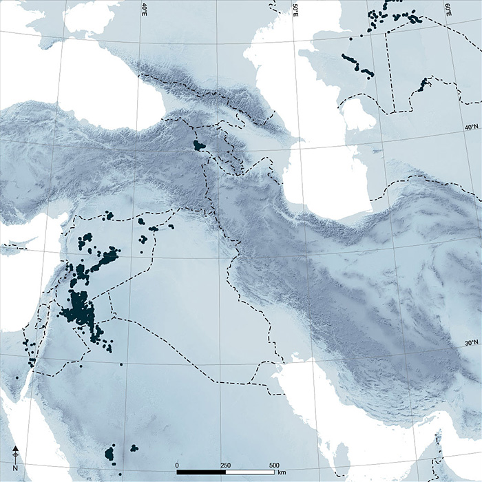
The distribution of kites, from Saudi Arabia to Kazakhstan.
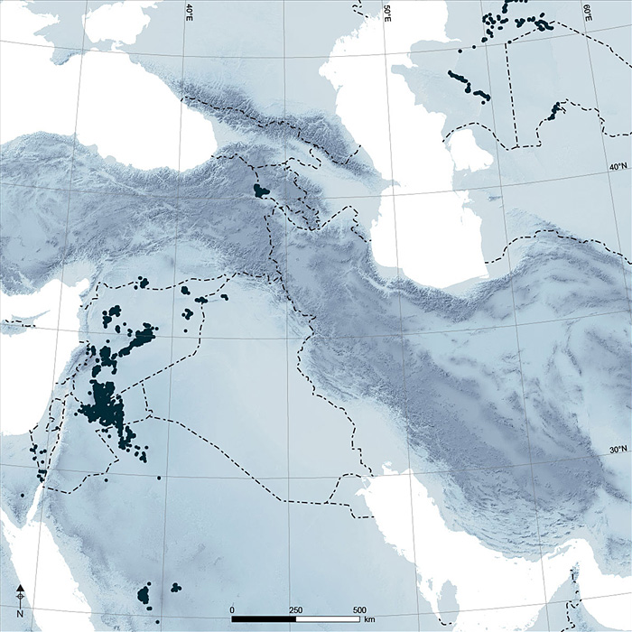
Within the last few years, the number of inventoried kites has increased fivefold, and the known distribution zone has been greatly extended. Based on the inventory by Reference KennedyKennedy (2012) and supplemented by our findings and other published data, it is clear that kites are distributed with varying concentrations and discontinuities (Figure 1). The GLOBALKITES Project is facilitating the study of these structures at regional and local scales via the GeoExplorer GLOBALKITES Interactive Map (http://www.globalkites.fr). This inventory demonstrates the surprisingly wide geographical range of kite structures, both in the Near East and in outlying regions. We refer to the extensive construction of these features as the 'kites phenomenon', and suggest that it raises questions about the origins of kites, for example, by diffusion or cultural convergence. The scale of this distribution also has implications for issues of dating and function, which both remain unclear.
Investigation of the 'kites phenomenon' is at the heart of the GLOBALKITES Project. The team comprises archaeologists, archaeozoologists, geographers and geoarcheologists, who are implementing an interdisciplinary approach previously little used in such studies. Satellite images provide substantial amounts of data that can be geomatically analysed, with the resulting spatial data used to identify and explain regional differences. To this end, an archaeozoological inventory and environmental characterisation are in progress. The fundamental issues, however, cannot be resolved without field investigations. This aspect of the research combines surface surveys and excavations, with special attention to architecture, and absolute and relative dating. In parallel, programming for automatic recognition of kites in Google Earth is being developed in collaboration with mathematicians and computer scientists.
The Armenian example and the 'kites phenomenon' in the Old World
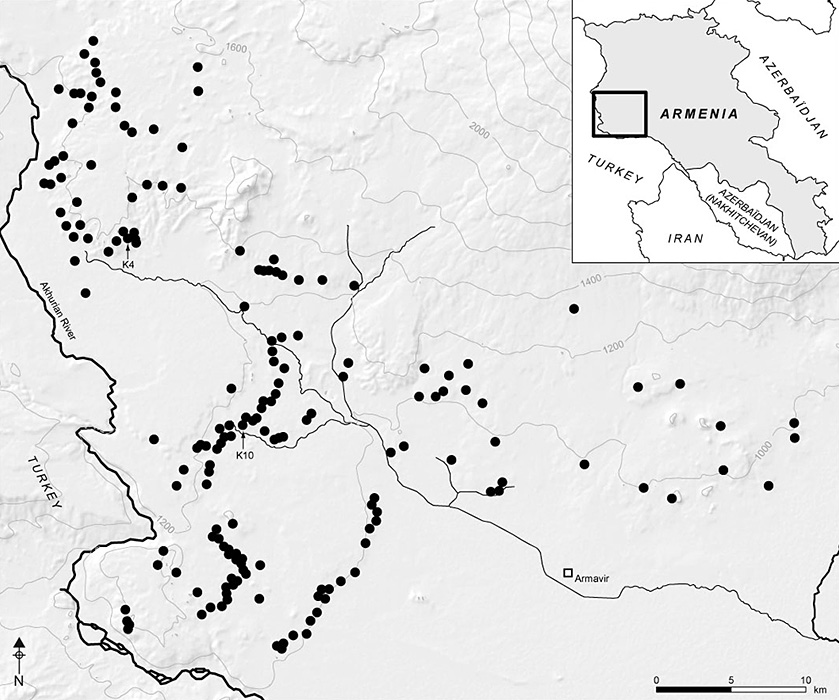
Mount Aragats kites, Armenia.
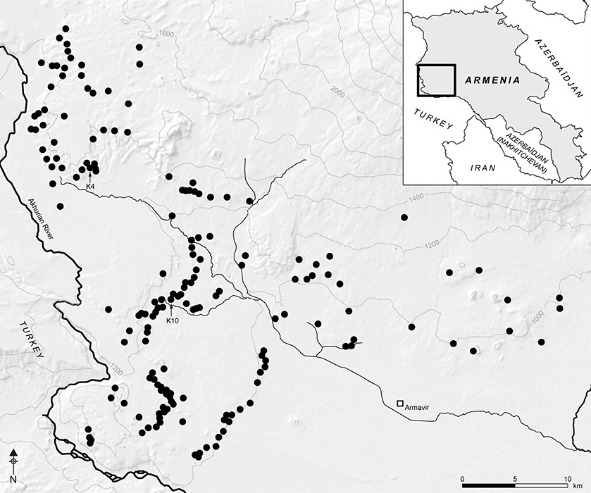
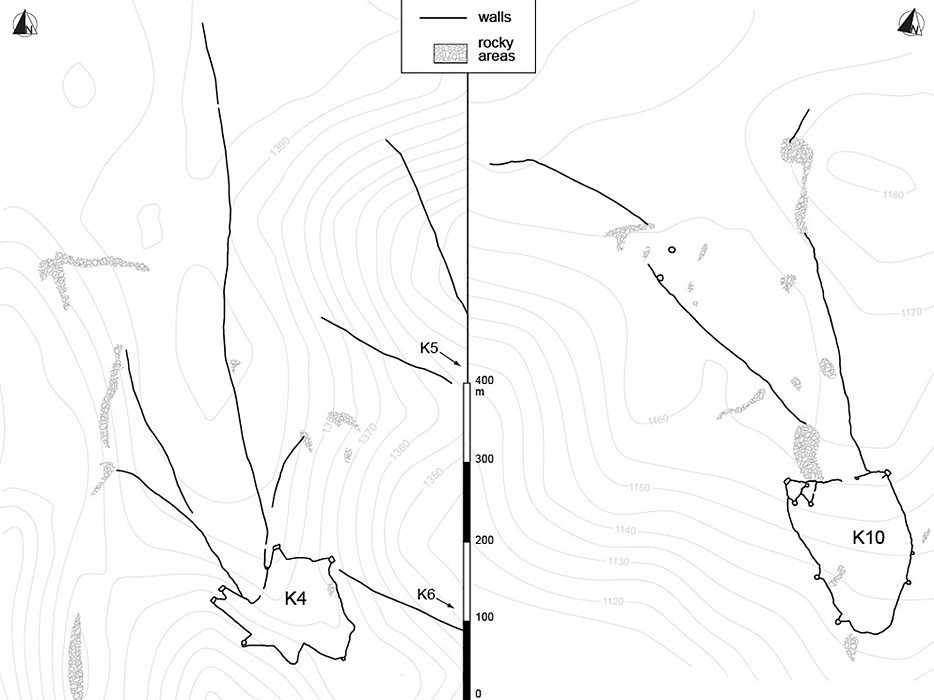
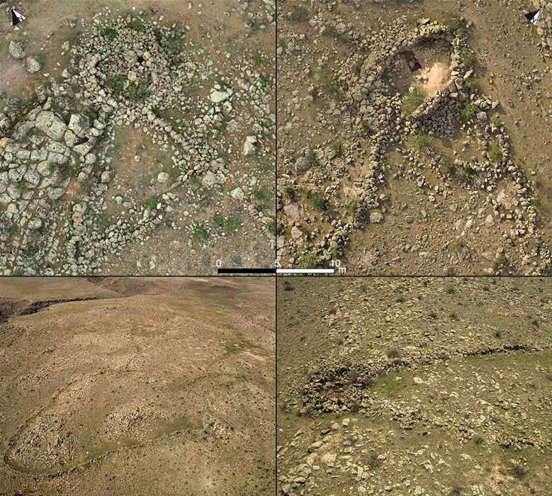
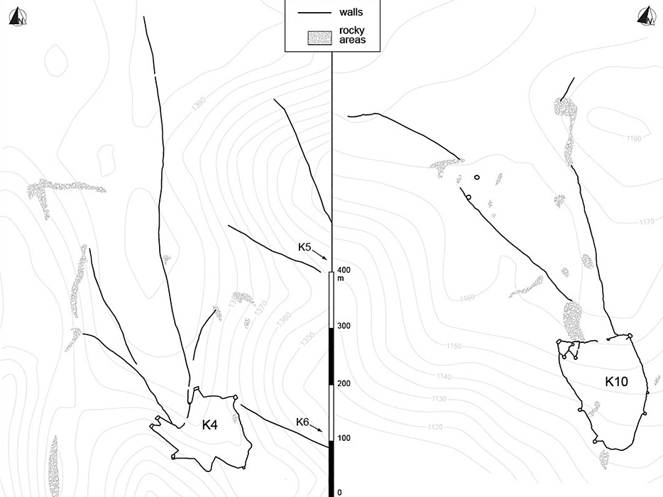
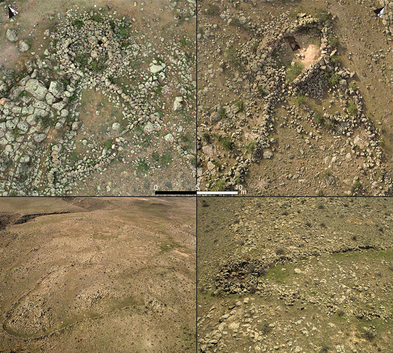
Fieldwork undertaken in Armenia on kites discovered in 2009 (by current author AK; Reference KarakhanyanKarakhanyan 2010) led to the identification and study of 173 such structures (Barge et al. forthcoming). No other kites have been identified in directly neighbouring regions—the Armenian kites seem to be an isolated occurrence covering an area of about 40km x 50km. Kites recently published by Gasparyan et al. (2013) are located in the eastern part of the Armenian series where the density is lowest (Figure 2) and where kites least respect a number of defining features that we were able to identify: our project determined that, generally, Armenian kites are linearly organised along the edges of lava flows, oriented along hillside slopes, and show a morphological homogeneity that indicates regional specificity, as shown by a Multiple Correspondence Analysis (MCA) of around 20 characteristics selected from satellite imagery. The enclosures are most commonly built in a simple ovoid shape, with one or several external pointed extensions with a compartment at each extremity (Figure 3), eventually creating a star-shape (Figure 4). These kites have strong similarities to those in the Near East, or the ones found to the north of the Aralo-Caspian zone (Reference Yagodin and BettsYagodin 1998); the simultaneous presence of three features (antennae + enclosure + compartment) distinguishes the Middle Eastern kites from other structures found elsewhere, for instance in North America and the Arctic. Surface artefacts are regularly discovered within the enclosures, but they do not seem to be more numerous than those from outside the enclosures, and they are not necessarily contemporary with the construction or use of the enclosures. Various other types of chronological evidence, however, date their construction to between the beginning of the Bronze Age and the beginning of the Common Era (e.g. post and ante quem superimpositions, construction techniques, radiocarbon dating of eggshells from stratigraphic contexts). This suggested age range will be refined by further chronometric dating of samples from test trenches excavated in April 2013. Located in the compartments at the ends of the pointed enclosure extensions, these test trenches did not yield any faunal remains or any other evidence to indicate the exact function of the structures. The compartments are made of corbelled double-faced walls with no entrance, while their floors are clearly lower than the floors of the associated enclosures (Figure 3). The precise function of the compartments—an architectural feature that seems to be essential to the function of kites—cannot be established at present, even if the structure of the kites and their integration in the landscape seem to indicate a function related to hunting.
Two examples of Aragats kites.
Armenian kites details, aerial photography.
Other similar fieldwork is planned in various areas spanning the known geographical distribution of kites. Our strategy consists of 1) analysing the characteristics of kites identified on satellite images; 2) field mapping of a representative sample of kites; 3) studying kite morphology, architecture and potential superimposition with other structures; and 4) excavating test trenches where the potential for obtaining chronological evidence is greatest. These field observations will test and enhance the interpretations based on satellite imagery. Moreover, they will help to secure the comparability of data from one region to another.
We suggest that the 'kites phenomenon' was more influential than previously understood. The human-animal relationships mediated by these constructions have both ecological implications, such as the environmental impact of these activities, and economic implications, such as territorial demarcation and control. In order to understand better the newly recognised extent of this phenomenon, it will be useful to reassess data quality and to situate studies in a precise context. We urge the scientific community involved in kite studies to share data and work in this direction.
Acknowledgments
We thank David Kennedy (University of Western Australia) for generously providing unpublished data about kites in Central Asia; Bruno Morandière (USR 3439) for his help in building the GeoExplorer map; Mathieu Adès (http://www.enteo.fr) for designing the project's website; and Sandra Dong and Laine Clark-Balzan for English editing. Research in Armenia (2011–2012) was financed by CNRS: LIA France-Armenia (to CC). GLOBALKITES research (2013–2016) is financed by Agence Nationale de la Recherche (no. ANR-12-JSH3-0004-01, to RC). Kite shapes recognition program (2013–2016) is financed by a Labex IMU grant from the University of Lyon (to OB and Hamida Lagraa, UMR 5205).