


1. Introduction
The field of wayfinding design and related research has, to a large extent, been concerned with the analysis of, and design interventions for, man-made environments (e.g. Lynch, Reference Lynch1960; Arthur and Passini, [1992] Reference Arthur and Passini2002; Passini, Reference Passini1977; Miller and Lewis, Reference Miller and Lewis1999; Mollerup, Reference Mollerup2005; Calori and Vanden-Eynden, Reference Calori and Vanden-Eynden2015; Barker, Reference Barker2019). Even so, there are elaborate wayfinding systems and wayfinding tools and information available also in more natural environments (e.g. The Norwegian Trekking Association (DNT), Innovasjon Norge and Friluftsrådenes Landsforbund (FL) 2019; National Pilgrim Center, 2023; Hadorn and Schweizer Wanderwege, Reference Hadorn and Wanderwege2013; Scheierl, Reference Scheierl2025). For example, signage and marking systems for paths and trekking (e.g. Deutschen Alpenverein (DAV), 2024; Club Alpino Italiano, 2016; Svenska Turistföreningen (STF), 2024; Ramblers, 2024; Naturvårdsverket [The Swedish Environmental Protection Agency], 2016) or digital route descriptions, itineraries (e.g. Walkhighlands, 2024; National Pilgrim Center, 2025), and applications and map services (e.g. UT, 2024; Komoot, 2024; Strava, 2024) that are specialised for use in the outdoors and in nature. In these environments, man-made objects might not be the most dominant environmental features and factors, but they will, in most places to a varying degree, also be present, unless we are in a true, intervention-free wilderness (Store Norske Leksikon, Reference Bolstad2020; Miljødirektoratet [Norwegian Environment Agency], 2024b). In addition, the coverage of Global Navigation Satellite Systems (GNSS) (Bonnor, Reference Bonnor2012) is available almost everywhere in the outdoors, regardless of level of remoteness or wilderness. In effect, this makes the whole globe covered by man-made technology, even though it is invisible to the human eye (see Figure 1). Examples of other man-made installations and objects in nature – aside from GNSS – can be paths, markings and signage, buildings, roads, pylons and towers, and even cultural landscapes in themselves, shaped by humans and domesticated animals over time and thus ‘man-made’.
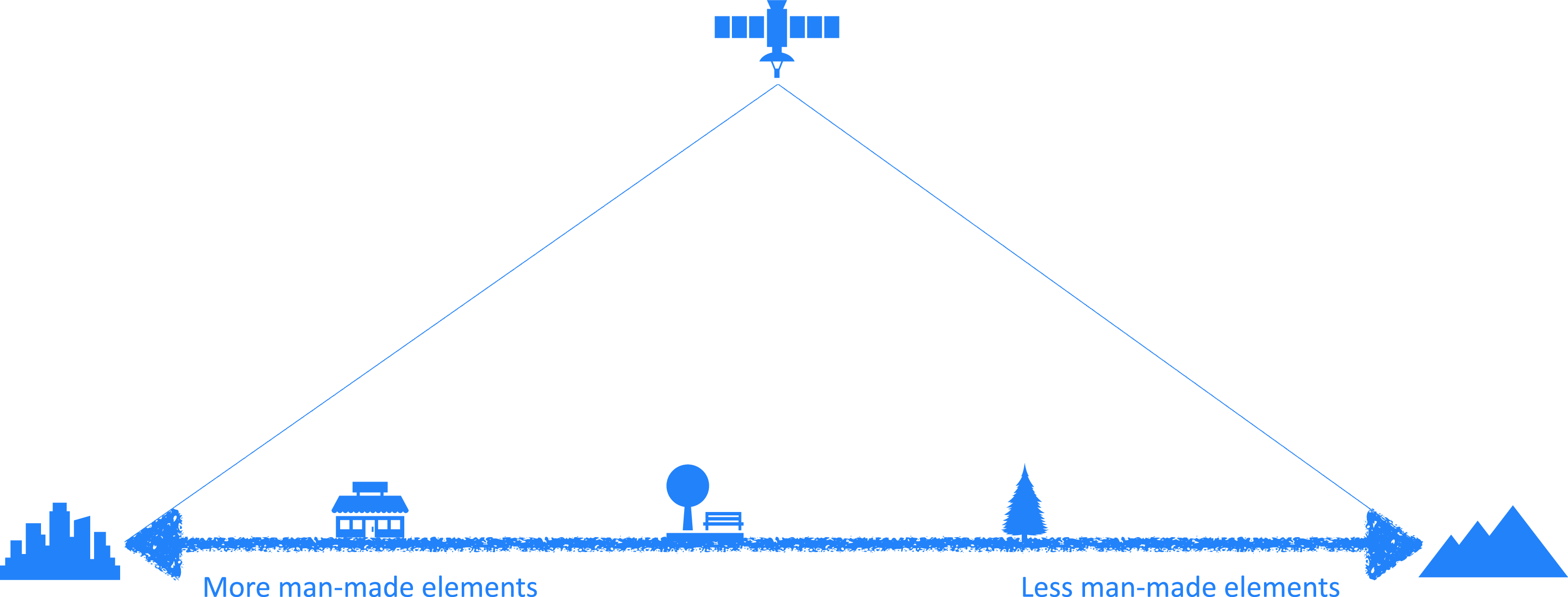
In the research conducted for this study, we have used previously defined and described wayfinding behaviours in man-made environments to inform our questions (see Table 1). The questions were formulated with the outdoors in nature as the relevant context and asked to our respondents. This was done to shed light on two aspects. First, to ascertain whether the described behaviours from the man-made contexts are also applicable in environments that are not necessarily labelled as man-made. Second, to ascertain whether some or all of the described behaviours are also used in the outdoors in nature (see Section ‘Research questions’). By doing this, we want to test if taxonomies of behaviours from man-made environments are useful in natural environments. These questions are raised with the perspective that a clear division between ‘man-made’ and ‘natural’ can be difficult to establish in our age of the Anthropocene (Rafferty, Reference Rafferty2018; Waters et al., Reference Waters, Zalasiewicz, Summerhayes, Barnosky, Poirier, Gałuszka, Cearreta, Edgeworth, Ellis, Ellis, Jeandel, Leinfelder, McNeill, Richter, Steffen, Syvitski, Vidas, Wagreich, Williams, Zhisheng, Grinevald, Odada, Oreskes and Wolfe2016). We outline a conceptual – though uneven – scale from outdoor spaces dominated by human-made structures, like dense cities, to wilderness with no visible human presence, such as remote mountains, deserts, forests or plains. In between the two ends of such a scale, there are landscape types and environments with a varied and diminishing presence of man-made elements going from dense urban outdoors at one end to intervention-free wilderness (The WILD Foundation, 2024; Miljødirektoratet [Norwegian Environment Agency], 2024a) at the other.
In between the extremes, we find suburban areas, parks, cultural landscapes, maintained forests, accessible hills, plains and mountain areas, and many other landscape types. However, even in the intervention-free wilderness of nature, there are man-made GNSS signals available, there are signals for satellite telephones and communication devices (Whalen, Reference Whalen2010; Berger, Reference Berger2022; Garmin, 2024), and in many – but not all – places, there is coverage of ordinary mobile phone signals with accompanying data traffic (GSMA, 2024).
1.1 Research questions
-
Can we identify overlap and matches between wayfinding behaviours for man-made environments and for the outdoors in nature?
-
Can Barker’s taxonomy of wayfinding behaviours for man-made environments, for paper and for screen, be used to identify behaviours in the context of the outdoors?
2. Theory
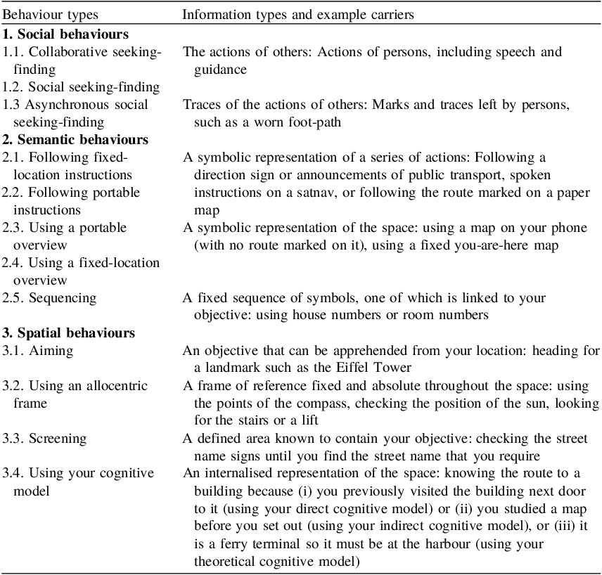
With a background in theory and description of wayfinding behaviours and design in predominantly built environments (Arthur and Passini, [1992] Reference Arthur and Passini2002; Miller and Lewis, Reference Miller and Lewis1999; Mollerup, Reference Mollerup2005; Calori and Vanden-Eynden, Reference Calori and Vanden-Eynden2015; Barker, Reference Barker2019), we set out to construct a questionnaire survey to identify wayfinding behaviours in the outdoors. In the field of wayfinding design, the focus has been on environments that are labelled as ‘man-made’. There is a rich body of theory which informs this field, with descriptions of wayfinding behaviours, tasks, strategies and use of tools.Footnote 1 Barker (Reference Barker2018, Reference Barker2019) has, through research into behaviour across the contexts of the built environment, the digital environment and paper-based media, established an elaborate taxonomy of wayfinding behaviours. Barker states that his taxonomy is influenced by previous research and literature, and he specifically mentions G.D. Weisman (Reference Weisman, Regnier and Pynoos1987), Mollerup (Reference Mollerup2005) and Passini (Reference Passini1981) as important influences when it comes to defining taxonomies for wayfinding in physical environments. Barker also conducted three user research studies to inform the taxonomy, and he cites Passini (Reference Passini1981, 27) to emphasise the fact that the behaviours he identifies are derived from the empirically found wayfinding information: ‘This leads one to view the information as being the important variable in determining wayfinding solutions’.
In previous research, we have successfully used Barker’s taxonomy to identify wayfinding behaviours among pilgrim tourists in Norway (see Wattne, Aandalen, and Jansson Reference Wattne, Aandalen and Jansson2025). We use Barker’s taxonomy as a theoretical backdrop also in this current study. In addition, we refer to findings from our other previous research where we established a typology of wayfinding behaviours derived from descriptions of being temporarily lost or disoriented in the outdoors: ‘A typology of wayfinding approaches to problem-solving when temporarily lost’ (Wattne and Volden Reference Wattne and Volden2024). In this typology, we describe, sort and categorise (recovery) wayfinding behaviours into four main categories: (a) Recovery by the use of materials, tools and technology; (b) Recovery by reading and interpreting the surroundings; (c) Recovery by movement and (d) Recovery by using existing knowledge and memory (individual or shared). These four main categories are in turn established ‘bottom-up’ from 20 sub-categories of identified and described behaviours. Some examples of these sub-categories of behaviours include: 5.1 Recovery by using digital maps; 5.5 Recovery by using terrestrial landmarks; 5.8 Recovery by general movement; 5.2 Recovery by using maps and 5.3 Recovery by following marks or signs. As we can see, the sub-categories of behaviours in this typology are a mix between being defined by information sources (digital maps, marks and signs, landmarks) and actions (movement, following) connected to, or triggered by, information. Also, the behaviours in this typology have considerable overlap with behaviours described from more general wayfinding settings like in Barker’s taxonomy, and as we shall see, from the research findings for this article.
3. Method
A questionnaire survey was assembled using the Norwegian survey platform nettskjema.no (University of Oslo (UiO), 2024) run by the University of Oslo. Nettskjema was also used for data collection and handling. Nettskjema is constructed according to privacy-by-design principles (Universitetet i Oslo (UiO), 2024) and handles privacy considerations among the respondents. The questionnaire was made in two versions: one in English and one in Norwegian language. The survey was distributed among postgraduate students enrolled in a module in scientific methods (The Norwegian University of Science and Technology (NTNU), 2024). The students were tasked with recruiting 15 respondents each through direct, personal recruitment (and not general posts on social media). With 41 students recruiting 15 respondents each and the students answering the survey themselves, the potential was 656 respondents. Overall, we received 401 respondents to the survey, which gives a completion rate of 61% (see Table 2). There were 108 respondents to the English and 294 to the Norwegian versions.
In the survey, descriptors from Barker’s taxonomy were used to generate questions matching each of the described behaviours. Furthermore, our own typology ‘A typology of wayfinding approaches to problem-solving when temporarily lost’ (Wattne and Volden, Reference Wattne and Volden2024) was used to inform the wordings of the answer options and to link already identified behaviours from natural environments to Barker’s descriptors. Since the descriptors in Barker’s taxonomy are on an overarching, abstract level, we used the empirically identified behaviour descriptions from our typology to inform the wordings of our questions into recognisable and understandable behaviours from the context of the outdoors. For example, this descriptor from Barker’s taxonomy:
2. Semantic behaviours: 2.1. Following fixed-location instructions
had the following answer option in our questionnaire:
-
Followed directional signs
and 2. Semantic behaviours: 2.5. Sequencing had the following answer option:
-
Followed trail markers such as red T-marks, cairns or sticks (for skiing)
Hence, the wordings of the options presented to the respondents in the questionnaire are derived from a combination of the categories and behaviour descriptors in Barker’s taxonomy, and Wattne and Volden’s typology (see Appendix 1 for the question, complete options of answers and numbers). In the results section below, we analyse the results according to each behaviour type and then we accumulate results according to the overarching categories social, semantic and spatial behaviours.
The resulting data from the questionnaire is thus based on self-reported choices and descriptions from our respondents, and their answers are based on memories. No actual behaviours have been observed or monitored for our data collection.
3.2 Participants and ethics
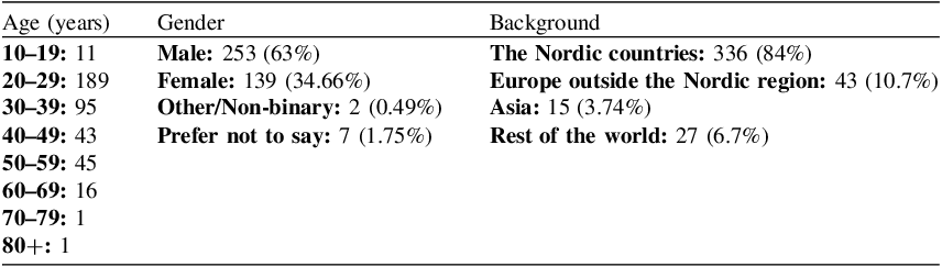
Based on the method of recruitment, we consider it likely that the participants in the study are biased towards an above average educational level and given the number of respondents using the Norwegian language version of the survey, there is a Norwegian cultural bias. The study also has an age bias. The ages 20–29 and 30–39 are the largest brackets with 189 and 95 respondents, respectively, and a combined 70.8% of the total respondents.
The gender distribution among the respondents is as follows: 253 (63%) male, 139 (34.66%) female, 2 (0.49 %) other or non-binary and 7 (1.75%) preferred not to say. To control for cultural biases and align with previous research indicating that the population in Nordic countries score high on navigational abilities (Coutrot et al., 2018), we included questions about where the respondents grew up, went to school and spent most of their lives until they turned 20. The largest number have a background from the Nordic countries with 336 respondents (84 %), then Europe outside the Nordic region with 43 (10.7%), Asia with 15 (3.74%), Oceania with 12 (2.99%), North America with 4 (0.99%) and finally South America with 3 (0.75%).
4. Results
The options for answering the question 3.1. Which of these behaviours or tools have you used to find your way in nature? are derived from the behaviours described in Barker’s (Reference Barker2018, Reference Barker2019) taxonomy of wayfinding behaviours. The respondents had the option to indicate as many behaviours as they remembered using, and therefore possibly contributing to, several of the categories and sub-categories of behaviours.
The highest number of our respondents (325/81%) reported to have used a digital map on a mobile phone to question 3.1. Which of these behaviours or tools have you used to find your way in nature? Figure 2 presents the reported behaviours in descending order (see Appendix A.1 for text-based results descriptions).
A conceptual scale of environments with more to less man-made elements going from dense urban areas on the left, and to remote wilderness without any visible man-made elements on the right. All areas covered by GNSS signals.

The wayfinding behaviours and tools used by the respondents (some have answered in multiple categories).

For the respondents who reported using digital maps on their mobile phones, we followed up with question 3.2. You have answered that you have used digital maps on your mobile phone. Please tick which type(s) of map you have used. This question received 323 responses with the following results and shown in Figure 3:
-
‘Generic maps such as Google maps or Apple maps’ received 299 answers (92.6%).
-
‘Outdoor maps such as UT.no, Hvor?, Norgeskart or others’ received 165 answers (51%).
-
‘Other apps or services that contain maps such as Strava, Komoot, Outdooractive etc.’ received 84 responses (26%).
-
‘Maps in social media such as Snap-map or Instagram’ received 47 responses (14.6%).
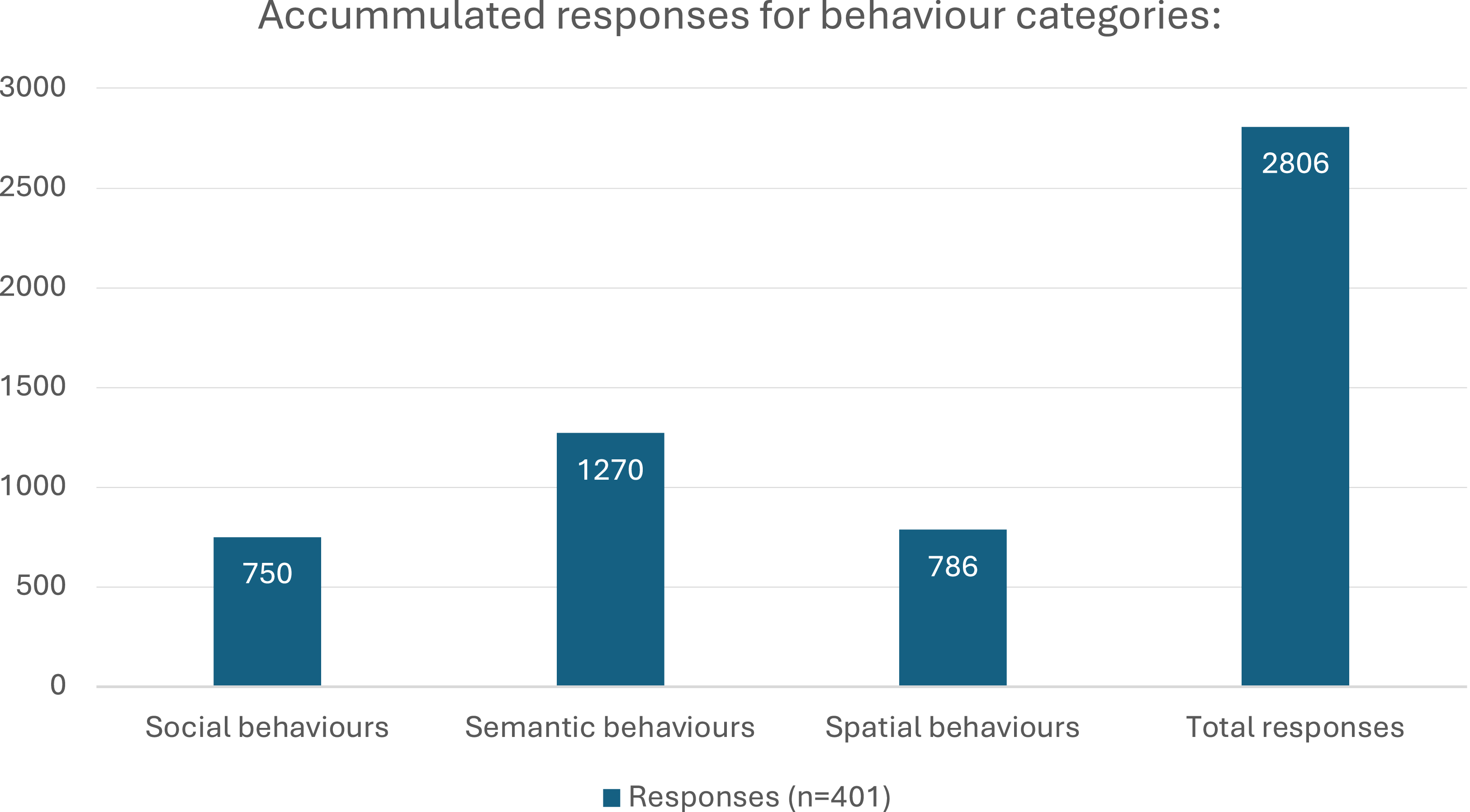
Figure 4 displays the accumulated results from the individual behaviour types reported and sorted into the over-arching categories social, semantic and spatial behaviours from Barker’s taxonomy.
The use of several types of digital maps on smartphones among the respondents.

A diagram of the accumulated responses for the three different, main categories of wayfinding behaviours including the total number of responses.

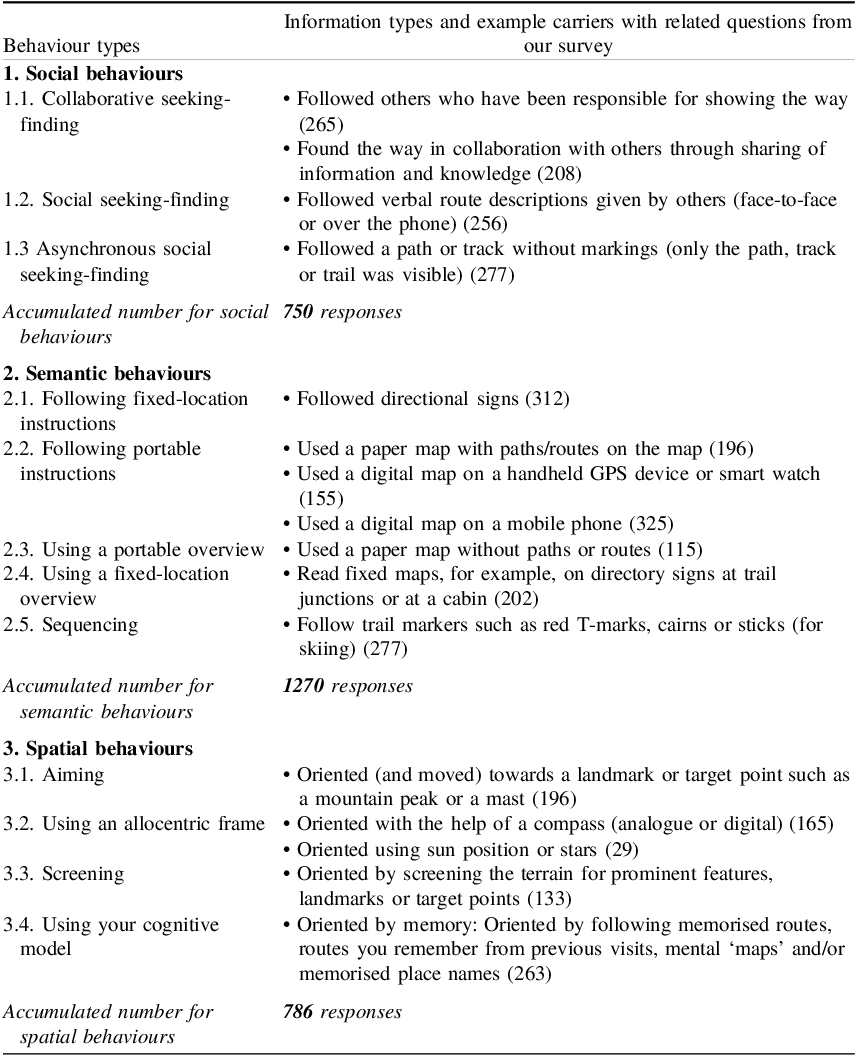
Table 3 provides an overview of the taxonomy with questions from our survey sorted according to categories of behaviours in it, and with accumulated numbers of answers for each of the three main categories social, semantic and spatial.
A taxonomy of wayfinding behaviours and corresponding information types, reproduced from Barker (Reference Barker2019)

Demographic variable among the respondents

Barker’s (Reference Barker2019) taxonomy of wayfinding behaviours and corresponding options and response numbers from our survey

5. Discussion
With a total of 401 respondents giving 2806 responses,Footnote 2 there is an average of close to 7 (2806/401 = 6.9975) out of 17 possible behaviours being reported by each respondent, indicating that they, on average, use a rich variety of information types leading to the reported behaviours. This is in accordance with described wayfinding procedures from man-made environments where people also use a mix of information and knowledge types – and hence behaviours – to find their way (Mollerup, Reference Mollerup2005; Dalton et al., Reference Dalton, Hölscher and Montello2019; Dalton et al., Reference Dalton, Hoelscher and Spiers2015; Passini, Reference Passini1981). For the choice ‘Other’ to the question 3.1. Which of these behaviours or tools have you used to find your way in nature?, we gave the respondents the opportunity to elaborate in free text. The following three descriptions were collected.
-
1. Following the water flow from a river for example, or just going downwards if I get lost in a mountain.
-
2. Followed streams and rivers to find the way to a water on the map. [Our translation].
-
3. To learn new paths and to get to know new places, I have gone on a lot of ‘lost-in-the-woods’ [‘skauleis’] ramblings. By that I mean walking in a balance between almost getting lost and to have it reasonably clear to me the approximate directions I can go in if I need to find known locations. [Our translation].
Numbers one and two could be sorted under ‘3.1. Aiming’ by the respondents describing aiming for a direction given by the flow of water, and the description ‘…just going downwards if I get lost in a mountain’ could be seen as using a mental model of the terrain at hand, paired with the knowledge that descending would be the right direction. Number three is harder to categorise, but it can be seen to involve the use of a cognitive model of the landscape since the respondent is reasonably clear about knowing the directions to known locations. The description is also an account of doing a form of exploration of an unknown terrain through challenging oneself by becoming ‘almost lost’. In the authors’ previous research, we received reports of users using general movement as a behaviour to recover from being lost (Wattne and Volden, Reference Wattne and Volden2024). This type of behaviour we label ‘Recovery by movement’, where the respondents describe targeted or more unsystematic movement as the behaviour that led to being re-oriented again.
In Figure 3 above, we see that the highest number of our respondents report using generic digital maps such as Google or Apple maps with 299 answers (92.6%), followed by specialised outdoor map-services with 165 answers (51%), then other outdoors apps or services that contain maps with 84 responses (26%). Finally, maps embedded in social media received 47 responses (14.6%). Generic digital maps do not necessarily provide good data with the required level of topographical detail for safe navigation in the outdoors in Norway, so the high number reporting to depend on them indicate a need to educate people in using more suitable services and apps in this context. This is also a potential safety issue, and reports from England and Wales indicate that people relying on inadequate map services on their phones lead to an increase in search and rescue missions in the outdoors (Vinter and Brooks, Reference Vinter and Brooks2025; Boulter, Reference Boulter2022; Harris, Reference Harris2025; The Guardian, 2025). Resources could possibly be spared and risk avoided if people used better maps. Outdoor activity apps and services like Strava and Komoot have better data quality in the maps for outdoors activities, but the best services are specialised maps for hiking and outdoors activities like the Ordnance Survey maps app (Ordnance Survey, 2025) and, in the Norwegian context, UT.no, Hvor? and Norgeskart friluftsliv (Ture apps AS, 2025). The number of respondents reporting the use of maps in social media is the lowest, but is still quite high at 47 (14.6%). Interestingly, there was recently a news story in Norwegian media about three people getting lost in nature in Spain and using the map in the augmented reality smartphone game Pokémon Go (Muhaisen, Reference Muhaisen2024) to find their way again. The Pokémon Go map is generated partly by other users’ data and had a higher level of detail, including trails, than Google maps, in the terrain in which they got lost.
The number of respondents reporting to have used social media maps in our study indicates that this map-based information influence and trigger ‘new’ wayfinding and navigation behaviours. Map information in social media is used for navigation and wayfinding purposes. This – of course – depends on how the maps in social media are used. However, what we see here is possibly an emergence of new types of social behaviours for wayfinding, where locations can be shared, and the behaviours of others can give information to influence your own wayfinding behaviour, mediated through social media platforms.
5.1 Discussion of research questions
For this study, we posed the following research questions.
-
Can we identify overlap and matches between described wayfinding behaviours for man-made environments and for the outdoors in nature?
-
Can Barker’s taxonomy of wayfinding behaviours for man-made environments, paper and screen, be used to identify behaviours in the context of the outdoors?
We think the questions have been answered through the research presented in this article. We have identified considerable overlap and matches between the collected behaviours from natural environments and those described from man-made ones. All descriptors from Barker’s taxonomy are identified in our material, and we have a high number of accumulated answers for the three over-arching categories of social, semantic and spatial behaviours, with semantic being the largest category in numbers. Our results indicate that existing taxonomies and descriptions of wayfinding behaviours from man-made environments are valid and can be useful for analysis and wayfinding design for natural environments. Following from this, the second research question is partially answered through the results: we have used Barker’s descriptors to identify behaviours in natural environments. However, we have translated the abstract descriptors into recognisable, individual behaviours written out in more everyday terms, in the questions posed to our respondents. As such, this research question is answered successfully, but with the need for some adaptation and re-writing of the descriptors of the taxonomy in the process. Accordingly, the taxonomy is useful for identifying behaviours, but the language of the taxonomy is in our experience not so useful in a direct application towards respondents.
5.2. Limitations
A reservation about the validity of the answers to the research questions would then be whether we have translated the behaviour descriptors of Barker into sufficiently precise questions to collect matching behaviours in our questionnaire. We believe we have achieved this, but we also acknowledge that there are debatable cases. For example, we classify the behaviour ‘Follow trail markers such as red T-marks, cairns or sticks (for skiing)’ as 2.5. Sequencing. It could possibly also be seen as an instance of 2.1. Following fixed-location instructions if we regard the trail markers as instances of direction signs pointing out and confirming a direction, instead of seeing them as ‘A fixed sequence of symbols’ as we have chosen to do.
Another possible limitation to the results is the phrasing of the question posed to the respondents in the questionnaire: 3.1. Which of these behaviours or tools have you used to find your way in nature? The question-and-answer options do not allow the respondents to indicate most used behaviour(s) on an individual level as there are no ranging options. The most used behaviours are only shown in the aggregated results from the whole population of respondents, as shown in Figure 2 and Table 3. Also, as a known limitation to self-reported questionnaire survey-based data, there might be a variant of the priming effect (Parkin, Reference Parkin2008) at play with the proposed behaviours in the answer options. Seeing a described behaviour as an option might bias the respondents to remember having used it and over-report it, or to put more weight on it in subsequent answers.
Furthermore, our collected data are from natural environments and do not contain any data on frequency of behaviours from urban environments. Accordingly, we have not been able to compare frequency between our data and data from urban settings. This could be the topic of further research and would need frequency data collected from both settings to compare.
6. Conclusion
Through a questionnaire survey and the analysis of the results, we have identified social, semantic and spatial wayfinding behaviours in nature in Norway. The behaviours from this context are similar to behaviours described from other, built environments and contexts. We thus demonstrate overlap and match between wayfinding behaviours in the outdoors in nature and behaviours described in the literature from man-made, digital and paper based environments. By this, our research also confirms that the descriptors in Barker’s taxonomy can be applied in the context of the outdoors. Moreover, our findings show that the most used behaviour among our respondents is the use of digital map services on the phone, a behaviour that is also common for wayfinding in the outdoors in built, urban environments (see for example: Hanchard, Reference Hanchard2024, 167–179). Also, in accordance with research from wayfinding in other types of environments, our respondents report using several behaviours in the context of the outdoors, averaging close to seven different behaviours reported per respondent. We also note the emerging use of a ‘new’ wayfinding information type from maps in social media platforms. We have sorted these findings under the behaviour type 2.2. Following portable instructions: Used a digital map on a mobile phone and show the detail of 47 respondents reporting this specific behaviour.
The aim of this research has been to fill in gaps in research on wayfinding behaviours across environments and situations, and to probe the validity of existing frameworks of described behaviours also in the context of wayfinding in nature. Wayfinding behaviour studies can serve as a bridge between human psychology and practical design of wayfinding information systems. Such studies generate knowledge that potentially can make navigation simpler and more efficient, and lead to heightened feeling of – and experienced – safety in the outdoors. Clear and intuitive wayfinding information reduces anxiety about getting lost and allows people to feel more confident in exploring unfamiliar natural spaces. Such a sense of security can encourage adventurers to take new routes and immerse themselves more fully in the endeavour, and the less adventurous to spend more time in nature. By reducing uncertainty and providing clear routes, wayfinding information can contribute to a safer experience of nature and potentially also reduce the need for rescue missions related to people getting lost. A similar effect can be achieved – without the need for physical design interventions in nature – by teaching people natural wayfinding and navigation skills. This can build more confidence in their ability to orient and navigate independently of physical markings or digital systems (Williams, Reference Williams2024). Investing the time and effort in this kind of schooling is perhaps more time and resource intensive than implementing better markings and information, but it requires less interventions in nature and would also build better resilience among people in critical situations. They would become less dependent on these types of information and hence behaviours, such as sequencing and following fixed-location instructions.
Appendix A
A.1. Which of these behaviours or tools have you used to find your way in nature?
Answer with number of answers (multiple options possible):
-
1. ‘Used a digital map on a mobile phone’ with 325 answers (81%).
-
2. ‘Followed directional signs’ with 312 answers (77.8%),
-
3. ‘Followed a path or track without markings (only the path, track or trail was visible)’ with 277 answers (69%).
-
4. ‘Follow trail markers such as red T-marks, cairns or sticks (for skiing)’ with 277 answers (69%).
-
5. ‘Followed others who have been responsible for showing the way’ with 265 answers (66%).
-
6. ‘Oriented by memory: Oriented by following memorised routes, routes you remember from previous visits, mental “maps” and/or memorised place names’ with 263 answers (65.6%).
-
7. ‘Followed verbal route descriptions given by others (face-to-face or over the phone)’ with 256 answers (63.8%).
-
8. ‘Found the way in collaboration with others through sharing of information and knowledge’ with 208 answers (51.9%).
-
9. ‘Read fixed maps, for example on directory signs at trail junctions or at a cabin’ with 202 answers (49.9%).
-
10. ‘Followed others I have assumed are moving in the right direction’ with 198 answers (49.4%).
-
11. ‘Used a paper map with paths/routes on the map’ with 196 answers (48.9%),
-
12. ‘Oriented (and moved) towards a landmark or target point such as a mountain peak or a mast’ with 196 answers (48.9%).
-
13. ‘Oriented with the help of a compass (analogue or digital)’ with 165 answers (41.1%).
-
14. ‘Used a digital map on a handheld GPS device or smart watch’ with 155 answers (38.7%).
-
15. ‘Oriented by screening the terrain for prominent features, landmarks or target points’ with 133 answers (33.2%).
-
16. ‘Used a paper map without paths or routes’ with 115 answers (28.7%).
-
17. ‘Oriented using sun position or stars’ with 29 answers (7%), and finally
-
18. ‘Other’ with 4 responses (0.1%).


 Open access