

In 2018, a team of the University of Strasbourg resumed fieldwork at Abu Shahrayn, ancient Eridu, under the supervision of Prof. P. Quenet. In the frame of the Archaeological Mission to Eridu (AMEr) directed by Prof. F. D’Agostino, University La Sapienza, Rome, the Strasbourg team continued work at the site in 2019 and 2022. Surveys and excavations conducted in 2022 have provided fresh results on the Chalcolithic and Bronze Age occupation of the Main Mound and neighbouring tells. This report is presented in two parts. The first part focuses on off-site studies and Site 1’s E-abzu monumental complex. The second part focuses on second millennium B.C.E. Eridu and the Kassite occupation at Site 4.
Part 1
Introduction (P. Quenet)
The Eridu Archaeological Area is located southwest of Nasiriyah/ الناصرية in South Iraq (Fig. 1). Several mounds are found within the area, of which the so-called ‘main mound,’ the highest (c. 22 m), is Abu Shahrayn/أبو شهرين (30°49’01.62” N, 45°59’46.57” E). It was first surveyed and excavated by John George Taylor in 1853‒1854 under the nominal direction of Henry Creswicke Rawlinson.Footnote 1 Taylor was succeeded by Reginald Campbell Thompson in 1918 and by Henry Reginald Holland Hall in 1919.Footnote 2 After all three had worked under the auspices of the British Museum, Fuad Safar resumed excavation in the later 1940s on behalf of the Iraqi Service of Antiquities.Footnote 3 Seton Lloyd was his technical adviser during the first two winter seasons (1946‒1948). A third and final winter season took place in 1948‒1949.
Location of the Eridu Archaeological Area within South Iraq and main regional geological and hydrographic features. Background image Bing Maps, coordinates in EPSG 32638. QGIS map F. Salomon, AMEr

The past excavations mainly focused on the main mound or ‘Mound 1,’ as labelled by Safar and Lloyd. Six other mounds are located nearby, within a 2–3 kilometre radius, numbered 2 to 7 (Fig. 2). Of these, Mound 5 is the largest, extending c. 25 hectares. It is therefore significantly larger than Mound 1, which is c. 18 hectares including its alluvial fan, but only c. 4.5 hectares within the perimeter of the temenos wall. The three remaining mounds are smaller: Mound 3 covers approximately 0.2 ha, Mound 2 is 7 ha, and Mound 4 is 10 ha. In the early 1990s, a quadrangular dyke was built to protect Mounds 1‒5 from flooding, because the Eridu/al-Ṣulaybiyyāt/الصليبيات depression was chosen to become a reservoir as part of the project to drain the marshes. Since then, this dyke marks the boundaries of the ‘Eridu Archaeological Area’.
Drone surveyed areas within the Eridu Archaeological Area. Background image Google Maps, coordinates in EPSG 3891. QGIS map and feature labelling J.-P. Droux and P. Quenet, AMEr
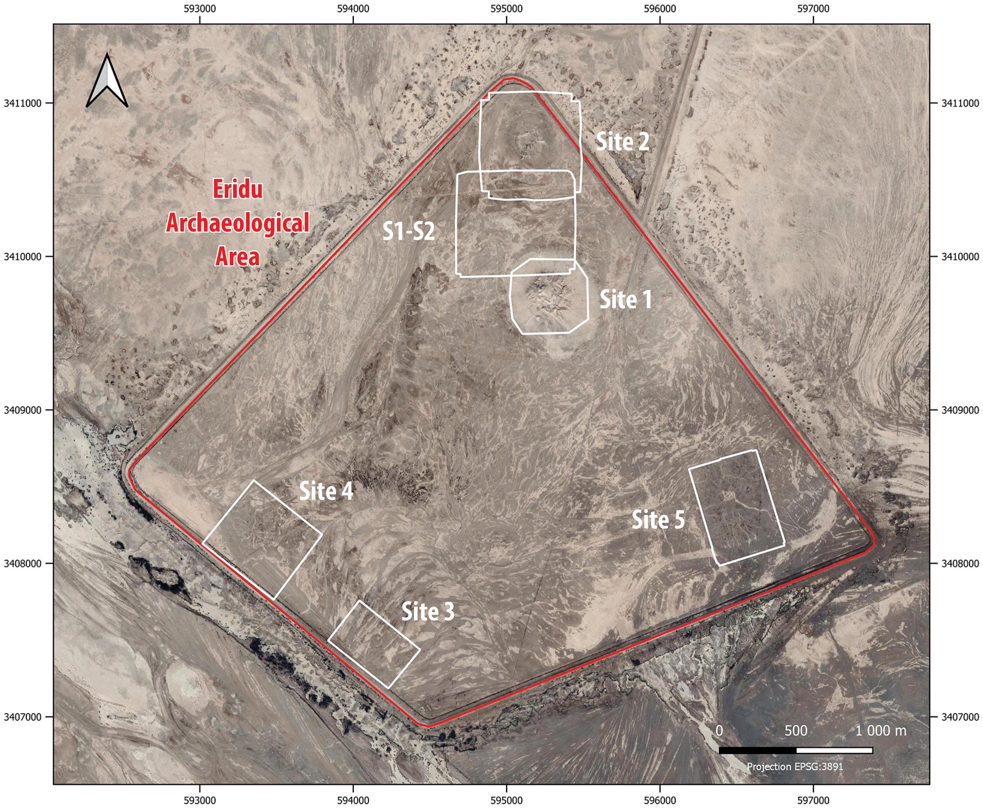
Excavation at Eridu was resumed in 2019 by the Archaeological Mission at Eridu (AMEr), an Iraqi–Italian–French team.Footnote 4 A short survey carried out at the beginning of the campaign showed that occupation levels, indeed burial grounds, extended widely around most of the mounds. These were consequently renamed ‘Sites’ 1‒5. Mounds 6 and 7, being outside the Eridu Archaeological Area, could not be identified or surveyed. In addition to a comprehensive study of the Eridu area, the primary aim of this new project was to investigate more specifically the stone temenos wall and the Ubaid Cemetery area. Work began on the southwestern side of Site 1, on its upper slope (Operations 1 and 3 of the French team) and at its base (Operation 2 and Ubaid Sounding of the Italian team).
These investigations continued, and others were undertaken for the first time, during the second campaign, which took place during two months from late winter to early spring 2022.Footnote 5 As in 2019, the excavation was directed by Prof. F. D’Agostino, University La Sapienza Rome, and the field director was Prof. P. Quenet, University of Strasbourg and Laboratory 7044 Archimède of the French National Scientific Research Centre. Iraqi colleagues of the SBAH contributed their expertise to the fieldwork. This report summarises the results of the French team of the University of Strasbourg.
The University of Strasbourg continued excavating on Site 1’s southwestern slope (Operations 1 and 3, fourth–second millennium B.C.E. levels) and opened a new area at Site 4 (Operation 6, Kassite levels). Site 2 and the stretch of land between Sites 2 and 1 were mapped with the use of a UAV (drone). The Site 4 geomagnetic survey was completed. Geoarchaeological and palaeo-environmental studies were initiated at Sites 1 and 4 and their surroundings. Preliminary results are presented here in two parts, the first dealing with the off-site studies and Site 1 and the second with Site 4 and the textual documentation related to Eridu’s second millennium B.C.E. occupationFootnote 6.
Aerial Topographic Survey, Site 2 Mound and Periphery (F. Galluser)
Aerial photogrammetry, implemented with the aid of a drone-borne camera, was first used in 2018 to map Site 1 and thereafter in 2019 to map Sites 3 to 5 (Fig. 2).Footnote 7 This work continued in 2022, and the survey was extended to the last remaining mound and immediate surroundings, that is, Site 2 and a section of its further periphery, specifically the stretch of land between Sites 2 and 1 (S1–S2 area). The drone used was a Mavic Air 2. Its flight plans were set up in the software Drone Deploy. Targets printed from the software Metashape were placed on the ground within the areas covered and georeferenced with a GPS device, Trimble DA2-BT. Image resolution was below 1 cm/pixel.
An area of 25 ha was covered, out of the 37 ha of the S1–S2 area. Footage consisted of 7,500 vertical and oblique photos; out of these, 5233 oblique photos were taken at a 65° angle. Additionally, photographic coverage of Operations 1 and 3 was carried out (0.5 ha, 2430 vertical and oblique photos). Photos were processed in Metashape Pro to create georeferenced 3D realistic models and orthophotographs. These were subsequently imported into the Eridu geographic databases built in QGIS and ArcGIS Pro.Footnote 8 Out of the about 1,000 ha of the Eridu Archaeological Area, approximately 18 % has been mapped (Fig. 2). This fraction, albeit limited, includes all the mounds.
The plan of the Level II Early Dynastic Palace excavated in the 1940s is clearly visible on the orthophoto of Site 2. Even a preliminary assessment indicates that it differs slightly from the plans published by its excavators.Footnote 9 The S1–S2 area displays features (consisting certainly of channels and perhaps of a new site)Footnote 10 that may prove crucial in the historical and palaeoenvironmental study of the area.
Geoarchaeological and Palaeo-environmental Studies (F. Salomon, C. Rambeau, J. Jotheri)
Geoarchaeological fieldwork was undertaken at Eridu in April 2022. This consisted of the first geological and geomorphological ground reconnaissance of the area, including sediment sampling for sedimentological and palaeo-environmental analyses. The work was conducted within the Eridu Archaeological Area and more precisely in and around Site 1 (Abu Šahrayn, sixth to second millennium B.C.E.) and Site 4 (second to first millennium B.C.E.), which were also the focus of geophysical surveys and archaeological excavations (Fig. 2). This geoarchaeological study has two main objectives. The first aim is to better understand landscape evolution through time and especially during the periods of occupation of the two sites. Second, this study proposes to investigate the taphonomy of Site 1.
Three sampling strategies were undertaken. These included: Surface collection of sediment on Site 1 to better understand its taphonomy; trenches around Sites 1 and 4 to study morphologies observed by satellite imagery (channels, canals); and boreholes around Site 1 to reconstruct longer-term landscape evolution (Fig. 3).
Geoarchaeological investigations in and around Site 1 and Site 4 at Eridu conducted during 2022. Background image Bing Maps, coordinates in EPSG 32638. QGIS map F. Salomon, AMEr

Geological, Geomorphological and Geographical Contexts
Eridu is located at the south-west margin of the Tigris–Euphrates delta in the al-Ṣlaybāt Depression (or al-Ṣulaybiyyāt Depression) (Fig. 1). This geological depression was formed by the movements of the Abū Jīr/أبو جير Fault Zone (also called the Euphrates Fault Zone) oriented NW-SE.Footnote 11 It created local sag ponds and pressure ridges at the periphery of the Dammām Formation, or Arabian Platform.Footnote 12 This depression is separated from the main current Euphrates deltaic plain by a ridge to the north and an outcrop possibly of the fluvial Dibdibba/الدبدبة Formation to the south.Footnote 13 The depression is filled by gypsum layers (inland sabkha) and Holocene sediments that originated essentially from the Euphrates but also from wadis running mainly from the Dammām/الدمان Formation and creating alluvial fans (Wādi al-‘Ašālī /العشالي, Wādi al-Qṣayr /القصير, Wadi al-Sdayr /السدير, Wādi Abū Ghār /ابوغار).
The al-Ṣlaybāt Depression is now a desert in a semiarid climate, covered by sand sheet, sand dunes and nebkha.Footnote 14 The Euphrates River flows in the depression between al-Najjār/النجار and al-Samāwa /السماوة, then runs towards al-Nāṣiriyya /الناصرية, the al-Ḥammār Marsh /هور الحمار, and the Šaṭṭ al-‘Arab River /شط العرب to finally reach the Arabic-Persian Gulf. To the south-west of al-Nāṣiriyya, Eridu is today located away from the Euphrates and its canals. Completed in mid-1993, the al-Qādisiyya River /نهر القادسية (or Fifth River /النهر الخامس) is a canal connected upstream to the Šaṭṭ al-‘Aṭšān /شط العطشان, a branch of the Euphrates River, and flowing into the al-Ṣlaybāt Depression.Footnote 15 It was part of the drainage works undertaken in the 1990s to drain the marshland of lower Iraq. In the same period, dykes were built around the archaeological sites to protect Eridu from the flooding of the area by the water of the Euphrates.
Palaeo-landscape Reconstruction around Eridu
Since the site of Eridu dates back to the sixth millennium B.C.E., this study aims to reconstruct landscape evolution from the last period of the Holocene coastal transgression to the present day. Data are still lacking to confirm that the Late Pleistocene–Early-Holocene transgression reached the al-Ṣlaybāt Depression.Footnote 16 In particular, we are looking for any evidence of the Hammār Formation around Eridu. This formation corresponds to brackish/marine fine deposits.Footnote 17 We also aim to reconstruct the evolution of the landscape since the first occupation of Eridu (marine, estuarine, or coastal environment; fresh or brackish marshes). To answer these questions, we focused on the area around the oldest tell in the Eridu Archaeological Area, Abu Shahrayn/Site 1. Two deep cores were drilled to the southeast and northwest of Site 1 (Fig. 3) to reconstruct long-term landscape evolution. Core ERIDU-S1 and Core ERIDU-S2 were drilled down to 8.20 m and 7.00 m depth, respectively. Samples were collected every 10 to 25 cm, depending on the characteristics of the sediment collected (e.g. cohesivity, hardness).
Geological/geomorphological trenches were excavated in features identified using satellite imagery. Surface morphologies and features should be of Mid- and Late Holocene periods, when the sea-level rise decelerated and the Euphrates and Tigris Rivers started to prograde.Footnote 18 Both on satellite imagery and in ground surveys, we observed particularly interesting fluvial and canal features. A palaeochannel was identified on satellite imagery next to and southwest of Site 4 (Fig. 3). This palaeochannel might be the one recognised during the ‘Eridu survey’ and dated at the latest to the fourth–third millennium B.C.E.Footnote 19 Next to the ditch associated with the dyke built around Eridu in the 1990s, a gully wall was used to start a stratigraphic profile. In addition, a trench was excavated at the bottom to obtain a 1.60 m-thick stratigraphy. This shows different types of fluvial environments, including coarse sand, fine deposits, and muddy pebbles. Based on the sedimentary data collected, we will aim to establish a link between the river deposits and the occupation of Site 4.
In collaboration with Jaafar Jotheri from the University of al-Qādisiyya, a trench was also excavated in a small irrigation canal to the north-west of Site 1.Footnote 20 The objective was to compare the characteristics of fluvial sediments in a natural channel and in a canal.
Taphonomy of Site 1
A study of the taphonomy of Site 1 was also initiated. A better understanding of the formation of the gullies, colluviation, and formation of dunes in Site 1 should allow us to evaluate the risk of erosion in the context of climate change. It will also help to evaluate the evolution of the site during its periods of occupation and abandonment. Ultimately, based on the study conducted both in laboratory and on GIS, we will make suggestions to preserve the tells in order to reduce the risk of erosion of archaeological layers.
In the field, we followed a source-to-sink approach from the centre of the tell to its surrounding fans, collecting samples on the surface and from the sides of erosion gullies. A large number of samples were collected in the source area of the tell, the gullies, the channels and levees and the fans following a northwest to southeast cross-section (Fig. 3).
Research Perspectives
This geoarchaeological study began in 2022. Laboratory analyses of the sedimentological data collected are ongoing and will allow us to characterise and date the different palaeoenvironments at Eridu and to calibrate the GIS taphonomic model of the site. However, the fieldwork conducted already revealed the high potential for geoarchaeological studies in Eridu. In the future, more systematic drilling is necessary to better understand the palaeogeography of the area and its evolution during the Holocene.
Site 1, SW slope: Operations 1 and 3 (P. Quenet, C. Koerin, M. Makinson)
Introduction
Excavation on Mound 1’s SW upper slope began in 2019.Footnote 21 The aim was to gather more precise data on the stone wall surrounding the mound. Taylor was the first to expose, in the SE, a portion of this wall face and an associated drain-chute,Footnote 22 which came to be known as ‘Taylor’s Buttress or Bastion’, for its actual function was established much later. In the late 1910s, this area was re-excavated by Thompson and Hall. The latter also cleared a stone bastion on the southeast side of the enclosure wall, about 150 m northeast of Taylor’s Buttress.Footnote 23
The wall outline was traced for the first time in the 1940s, and selected portions were excavated. From the evidence retrieved, its whole circuit was reconstructed.Footnote 24 It was interpreted as the temenos wall that marked the outer limits of the religious precinct known as E-abzu, inside which only the most massive building is still visible, the E-unir ziggurat, abode of the city-god Enki. This wall was even ascribed a more specific function, that of a retaining-wall. It is unfortunately described only broadly in the final publication. Elevations are missing, and few details are provided on building techniques.
Well behind this wall in the southwestern part of the site, below and around the ziggurat south corner, the excavators of the 1940s carried out a deep sounding to virgin soil, the ‘Temple Sounding’.Footnote 25 It is famous for providing a sequence of 18 architectural levels (Level XVIII being the lowest), well preserved and containing a wealth of sherds, which laid the ground for our understanding of Ubaid periodisation.Footnote 26 Levels V‒II consisted of truncated terraces that are likely to have supported a building (Fig. 4). Terrace I was built against Terrace II at a lower level. It has a white-plastered shallow-stepped face, the upper edge of which had a wavy contour. Its top floor was preserved.Footnote 27
West corner of Eridu Ur III Enki’s precinct, location of Operations 1 and 3 relative to the E-Unir, Terraces I to V, and Safar’s SW Trench as mapped in 1947 (al-Asil et al. Reference Al-Asil, Lloyd and Safar1947: site-map) and 1974 (Lloyd Reference Lloyd1974: pl. XVII). Coordinates in EPSG 3891. Background orthophoto E. Jund (after 1926 RAF aerial photos), CAD, ArcGIS map, and feature labelling Y. Idam, E. Jund, and P. Quenet, AMEr

No internal evidence helped the excavators dating these late terraces. As they were built in a period following Ubaid 4, as represented by Level VI, and the artefacts discovered in the fill in front of Terrace I dated back at the latest to the Uruk period, Terraces V‒I were considered likely to date to the Uruk period as well.Footnote 28 The excavators of the 1940s also dug a narrow trench, the South-West Trench, from the edge of Terrace I down to the top of the Temenos Wall (Fig. 4), in order to reveal a stratigraphic connection between the two. It is documented by a single photo in the available publications and hardly commented uponFootnote 29. Our 2022 excavation ended up demonstrating that its location on the published plans is mistakenFootnote 30.
We considered that it was worth resuming work in the same area, which seemed promising, to complement the old data. Therefore, two excavation areas were opened by AMEr. Operation 1 was located where the Temenos Wall face had been denuded by erosion, and Operation 3 was located about 15 m further to the southeast, where in situ baked bricks were conspicuous on the surface (Figs. 4–5).Footnote 31
Location of Operations 1 and 3 on the SW slope of Mound 1 and main features. Drone photos F. Galluser, orthophoto J.-P. Droux, Unistra-CNRS 7044, Strasbourg. Background image Eridu GIS (QGIS), coordinates in EPSG 32638. Feature labelling P. Quenet, AMEr

Operation 1 extends from Safar’s Temple II Terrace wall to lower on the slope, across the stone Temenos Wall (SU2) (Figs. 4–5).Footnote 32 As the stratigraphy is disrupted in this area by the stone wall itself, two segments are distinguished, an upper and a lower, each with its own stratigraphic sequence. The upper segment complements the Temple Sounding sequence, whereas the stratigraphy of Operation 3, an area never excavated before, was established independently (Table 1). All three sequences were eventually correlated, so the Temenos Wall and its associated ramparts and glacis were assigned to two main phases. These are dated with some confidence to the Ur III and Isin-Larsa periods, respectively (Table 2).
Eridu, SW slope, correlated sequences of Safar’s Temple Sounding and AMEr’s Operations 1 and 3. See explanation for the numbers with and without prime (e.g., 6 versus 7′) at end of the following section

Eridu, SW slope, tentative periodisation of the Temenos Wall and main associated features. Black: initial phase; grey: subsequent phase(s) of use or existence; “?”: dating supported by indirect evidence; “??”: possible dating. LC=Late Chalcolithic, JN=Jemdet Nasr, ED=Early Dynastic, Akk=Akkad, Ur III=Third Dynasty of Ur

Operation 1 Upper Segment
Operation 1’s upper segment is a 5 meter wide by 23 meter long area. Previously excavated areas were identified in its uppermost part, presumably the portion of Taylor’s Trench 2 (SU24) dug into Terrace I in front of Terrace II’s retaining wall (labelled 1 on Fig. 5) and Safar’s SW Trench in square F-7 (SU19; labelled 2 on Fig. 5).Footnote 33 Taylor’s trench was re-excavated in the 1940s, but it was misattributed (Thompson did not dig in this area) and its actual extension misidentified (see below).Footnote 34 For the following discussion, Fig. 6 indicates the orientation of the photos in Fig. 7‒17 and the location of the features referred to in the text.
Operations 1 and 3, location of photographed features. Photo orientation indicated by arrows. Drone photos F. Galluser, orthophoto J.-P. Droux. Background image Eridu GIS (QGIS), coordinates in EPSG 32638. Feature labelling P. Quenet, AMEr

Operation 1 upper segment, Terrace II and I, Taylor’ s Trench 2 and Looters’ Hole filling. Photo C. Koerin, feature labelling P. Quenet, AMEr

The weathered remains of Terraces II and I were partly uncovered anew. Terrace II’s retaining wall (SU22) is a white-plastered stone wall, described in several earlier publications (Fig. 7).Footnote 35 It is unclear whether it served as a facing for Terrace III’s mudbrick work or was added to it later, so as to build a new terrace. Nonetheless, one may assert, as was observed in the 1940s, it is preserved at a higher elevation than Terrace I’s plastered floor (SU21). Terrace I’s stone core, two column bases and sloping, undulating and stepped face (SU23) were found to be identical to the description given by their excavators.Footnote 36
Ten to 20 cm below Terrace I’s edge, a sloping grey revetment (SU18), 20 cm thick on average, was encountered, abutting the terrace face (Fig. 8) and consisting of sand-tempered mud mortar, sparsely mixed with debris such as Ur III baked brick chunks and rubble stones; it therefore has an uneven surface. The same material was used to in-fill a presumably ancient looters’ hole (SU44), roughly oval shaped, dug into Terrace I next to Taylor’s trench (Fig. 2). Taylor is therefore not responsible for it. Underneath the grey mortar layer was a powdery white plaster (juṣ) revetment (SU27) (Fig. 8). This is the surface of a 10–50 cm thick layer that contains white plaster lumps, as evidenced in the northwest section of Safar’s trench. It had been laid over a hard packed brown clay filling containing chunks of large bricks made of almost pure brown and grey clay (SU31). This filling functions as a rampart, over which was laid a white coated glacis followed later by a grey one.
Operation 1 upper segment, undulating face of Terrace I, Upper Grey Glacis and Lower White Glacis. Photo C. Koerin, feature labelling P. Quenet, AMEr

The whole construction was designed to obliterate a previous stone wall (SU30) and its associated glacis (SU32) and thus to create a smooth sloping surface where there had been a step before. Both the wall and its glacis – quite steep to judge from the meagre evidence retrieved – were white plastered (Fig. 9). They had already been exposed by Safar in his SW Trench, photographed but hardly described.Footnote 37 The wall is made of white stone blocks jointed with plaster. Its preserved top lies about 1 metre lower than Terrace II’s floor. This wall has been named ‘Terrace 0’, although its precise function still eludes understanding. Either it is the retaining-wall of a terrace built later than Terrace I at a lower elevation or (and?) an earlier temenos wall. Another issue is its stratigraphic position. Was Terrace 0 preceded or followed by other building phases? None of these questions can be solved yet due to lack of evidence.
Operation 1 upper segment, Terrace 0 and its white-plastered glacis in Safar’s SW Trench. Photo C. Koerin, feature labelling P. Quenet, AMEr

The stratigraphic connections between the two glacis and the Temenos Wall are lost in the area excavated. The corresponding archaeological strata have been destroyed by a temporary rivulet (SU41) that once carved a gully above the Temenos Wall in a line parallel to it (Fig. 5). However, the slope gradient of the two glacis makes it likely they both went down to the Temenos Wall – either its top, provided its full height has been preserved to the present day, or its inner face if it originally rose higher (see below). Regarding the Looters’ Hole, it obviously predates the construction of the grey glacis. If repair works were required when the grey glacis was laid, looting must have occurred just before, i.e. after the construction of the white glacis. Other clues support this hypothesis (see below).
To sum up, nine phases have been defined in Operation 1’s upper segment (Table 1). The first six phases are:
1 – Subsurface
2 – Safar’s SW Trench
3 – Taylor’s Trench 2
4 – Upper Grey Glacis
5 – Looters’ Hole
6 – Lower White Glacis
The next four phases, 7 to 10, are primed (7′ and so on) to suggest uncertainty in the connection to the above, because it was impossible to determine if the Lower White Glacis directly overlaid the Temenos Wall or if the latter was built immediately after Terrace 0, with no construction works in the interval. These four phases are:
7′ – Temenos Wall
8′ – Terrace 0 and its glacis
9′ – Terrace I
10′ – Terrace II
All ten phases do not strictly follow one another in time. Some structures were reused long after they were built. Terrace I was built against Terrace II at a lower level, so they must have functioned simultaneously for some time. The same is probably true of Terrace 0, which is likely to have added a new step in front of Terrace I. Terraces II and I were reused when the White Glacis was laid, and Terrace I, at least, if not Terrace II as well, remained in use during the following phase, which is represented by the Grey Glacis.
Operation 1 Lower Segment
Operation 1’s lower segment spans a width of 15.4 m by nearly 7 m (at its maximum length). In the northwest, a c.10-m wide area was excavated in front of the Temenos Wall SU2 (Fig. 10). Its northwest and southeast baulks revealed two crucial stratigraphic sections. The remaining c. 5 m to the southeast were investigated mainly by surface scraping. This operation helped define the Temenos Wall and the two associated glacis that extend in front of it. In the entire excavation area, the subsurface mostly consisted of colluvium deposits, overlaid, in the northwest end, by dig spoil heaps of the 1940s (SU9). These deposits had especially accumulated in an ancient gully that ran from further upslope down to the base of the northwest portion of the Temenos Wall. Here, near the wall’s face, a foundation nail of the king of Larsa Nūr-Adad (1865–1850 B.C.E.) was found loose among the fill (SU1).Footnote 38
Operation 1 lower segment, Temenos Wall and its two glacis. Photo C. Koerin, feature labelling P. Quenet, AMEr

The Temenos Wall has a facing of stone blocks mostly c. 40 cm thick (Fig. 10).Footnote 39 Their outer faces were hewn roughly flat. Six courses are preserved in the southeast end of the area excavated in front of the wall, whereas only three survived in the northwest. The lowest course rests on a brown hard-packed clay layer (SU17). The wall face gently slopes inward. Patches of white plaster still adhere to the outer face or sides of a few blocks.
This stone walling retains a filling of rubble stones and occasional brick fragments embedded in mud mortar (Fig. 11). One of these fragments (ER.19.1.1.2.1A) was found lying at a much lower level than the top of the original wall face. It bears an inscription of the Ur III king Amar-Su‘en, thus providing a terminus ab quo for construction of the wall. In its present condition, the top of this filling slopes at a comparable angle to that of the two upper glacis. Two lower glacis were also identified in front of the Temenos Wall, the lowest of which abuts the third course of the wall face. It is better preserved near the southeast baulk and has a thin white surface (SU3) (Fig. 12). It is attested elsewhere by a layer that contains white plaster lumps, such as in the slope in front of the stone wall, and is sometimes encrusted with sand, as in the northwest baulk (SU4) (Fig. 10). In 2022, traces of this Lower White Glacis were found lower in the slope (SU40), below surface aeolian and colluvial deposits.
Operation 1 lower segment. The rubble stone filling behind the Temenos Wall facing. Photo C. Koerin, AMEr

Operation 1 lower segment, SE section, surface of the Lower White Glacis. Photo P. Quenet, AMEr

Remains of a later glacis were exposed in the southeast half of Operation 1’s lower segment. This Lower Grey Glacis is made of grey mortar, generally encrusted with sand and occasionally mixed with rubble stones. In the excavated area, in front of the Temenos Wall, as shown by the southeast section (SU12), it reaches the top of the uppermost course of stones (Fig. 13). It has eroded away higher up. At two meters from the wall face, it meets the Lower White Glacis and directly overlies it from this point.
Operation 1 lower segment, SE section, surface of the Upper Grey Glacis. Photo C. Koerin, feature labelling P. Quenet. AMEr

Further to the southeast, a northeast-southwest gully had destroyed SU12, but beyond it, a narrow strip of the same Lower Grey Glacis (SU16) was preserved (Fig. 14). It runs over the Temenos Wall face and the filling behind it, whose rubble stones, albeit superficially denuded, are interspersed with remnants of grey mortar. Therefore, one may reasonably conclude, despite missing stratigraphic connections, that the grey glacis ran all the way over the Temenos Wall up to the edge of Terrace II.
Operation 1 lower segment, strip of the Lower Grey Glacis running over the Temenos Wall. Photo and feature labelling P. Quenet, AMEr

The data presented above allow for the establishment of a sequence divided into two main levels (Table 1). The upper one, Level 1, corresponds to the subsurface, and the lower one, Level 2, to the construction of the Temenos Wall (Phase 2c), the Lower White Glacis (Phase 2b) and the Lower Grey Glacis (Phase 2a). Identical phases have been recognised in Operation 3, where an additional structure, understood as a water drainage facility, can be integrated into that time frame.
Operation 3
Operation 3 was opened in 2019 and can be considered a south-eastward extension of Operation 1’s lower segment, with which it became contiguous in 2022.Footnote 40 It runs 14.4 m along the front of the Temenos Wall, here labelled SU9. In this area, a stepped, baked brick structure (SU2), preserved in its original state, abuts the E-abzu enclosure wall (Fig. 15). Its two building phases are stratigraphically related to two glacis layers: a Later Grey Glacis (SU3), which is the continuation of Operation 1’s Lower Grey Glacis, and a plastered and greyish Earlier Glacis (SU10).
Operation 3. The Stepped Structure and its two glacis. Photo and feature labelling P. Quenet, AMEr

The Stepped Structure has a maximum length and width of 5.9 m and 3.6 m, respectively. In its earlier phase, it was narrower (c. 3 m) and built of square baked bricks (25–27.5 cm), some of which are stamped with an inscription of the Ur III king Amar-Su’en.Footnote 41 It was restored and enlarged at the northwest during a second phase (Fig. 16). Earlier bricks were reused, and rectangular yellow bricks added (mostly 27 × 17 cm), either on top of the old bricks or next to them. The bricks that were examined were not stamped.
Operation 3. NW side of the Stepped Structure, later phase brickwork enlargement. Photo and feature labelling P. Quenet, AMEr

Whereas the lower two-thirds of the structure show one-brick high regular steps, the upper third was built differently. Only the sides, six courses high and c. 42 cm wide, were built of bricks, leaving a hollow centre quadrangle (SU6), the bottom of which is irregularly paved with square bricks (Fig. 17). This empty space was filled with mud mortar and covered with a partly weathered, hard grey coating. The structure’s uppermost two brick courses are again complete and partly rest upon the mud filling. The same sloping, hard grey revetment (SU3) as that exposed in Operation 1 surrounds the Later Stepped Structure on all three sides (Fig. 15). This makes it clear this structure was not a staircase but some other kind of facility, designed perhaps to drain rainwater, in a cascade-like manner, from above or from a floor level on the inside of the Temenos Wall (see below). This Latter Grey Glacis, in which rectangular yellow bricks are occasionally embedded, also runs over the Temenos Wall in this area.
Operation 3, the hollow in the Stepped Structure upper brickwork. Photo and feature labelling P. Quenet, AMEr

The same building technique as that of the Temenos Wall in Operation 1 has been observed here: the stone facing serves as the retaining-wall of a terrace whose core is made of rubble stones and mud mortar. Still, a different arrangement prevails behind the Stepped Structure, where the enclosure wall has a clearly defined, straight inner face. This may hint at the absence of an upper glacis in this area and the existence of a wall standing high above the level of a floor. Should this guess be correct, the Temenos Wall would have only partially functioned as a terrace retaining wall.
The sounding carried out in front of the Stepped Structure resulted in the discovery of an Earlier Glacis (SU10), whose revetment is made of greyish plaster (juṣ) (Fig. 15). Unfortunately, in the area investigated, its connection with the Stepped Structure had disappeared. Moreover, this Earlier Glacis was not found below the sand and gravel filling supporting the Later Grey Glacis in the northwest of Operation 3. Deeper excavation in future is required to ascertain its presence in the area studied. However, as both the Earlier Glacis and the Lower White Glacis are plastered, it is likely they are one and the same. One may also logically infer the Earlier Glacis was linked to the Earlier Stepped Structure.
Conclusion
Safar’s Temple Sounding and AMEr’s Operations 1 and 3 provide sequences which can be synchronised and consequently enhance our understanding of the evolution of the layout of the massive brick and stonework structures exposed on Mound 1’s southwest slope (Table 2). Terrace I was a step-like addition to Terrace II’s sloping white-plastered face. It was also white plastered all over (face and top floor). It may have supported a portico. Terrace 0 was built (immediately?) afterward as an additional step at a lower level. It had a white-plastered (top floor and?) face, in front of which a seemingly steep, white-plastered glacis extended. At this stage, this monumental, gradually developed complex included at least two steps.
Slightly later in time, the latest Temenos Wall known was built as an expanded version of Terrace 0, to supersede it. A white-plastered glacis was laid between the edge of Terrace II and the top of this wall, which could have been hardly taller than it was in the subsequent grey glacis phase and it is in the present day. A new rampart coated with a white-plastered revetment was constructed against the wall’s lower stone courses. This glacis may have run down to the bottom of Mound 1’s southwest slope, as illustrated by the thick, white-plastered layer found during 2019 in Operation 2’s southeast Square.Footnote 42 The Temenos Wall was equipped with a water drainage facility in the form of a stepped structure made of baked bricks.
All these structures were later restored, with few modifications as far as can be judged from the available data. Eventually a continuous grey glacis ran from Terrace II’s edge down along the slope across the Temenos Wall, which consequently was obliterated. Operation 3’s Stepped Structure was enlarged and put back into service and surrounded by a new grey waterproof revetment. Remains of this glacis have not been detected lower on the slope, nor were traces of later works conspicuous in the entire area, except for those left by the archaeologists who excavated in this part of the mound from the mid-nineteenth century onward.Footnote 43
Dating evidence is sparse. Nūr-Adad’s foundation nail was found out of context and is unfortunately of no value. The Stepped Structure is our best guide. The rectangular yellow bricks are generally considered Isin-Larsa in date at Eridu.Footnote 44 This assumption is mainly based on the results of the Ur excavations.Footnote 45 These bricks are occasionally stamped with a double crescent. It is noteworthy that the double-crescent brick type specifically points to the reign of Sîn-iddinam (1849–1843 B.C.E.), son of Nūr-Adad and his successor to the throne. For instance, a brick from Ur (U.3115/BM 119276, 1927,1003.271, from Area PDW) is stamped with both the name of Sîn-iddinam and a double-crescent motif.Footnote 46
The double-crescent brick type was used to build Taylor’s Buttress, or the latest drain chute on the southeast side of the Temenos Wall,Footnote 47 as well as similar structures against the northwest and northeast walls of “the bastion projecting from the retaining-wall of Eridu” in the northeast.Footnote 48 Additionally, one may note the presence of a “Larsa period pavement”, built of “broken bricks, bearing the stamp of a Larsa king”, on top of Terrace I, suggesting this terrace was still in use during this period.Footnote 49 The Grey Glacis and its associated features in Operations 1 and 3, as well as other late architectural remains at the site, are therefore likely to be the result of the restoration work Nūr-Adad claims he carried out at Eridu and his son perhaps continued.
It has been demonstrated above that the Looters’ Hole predates the Upper Grey Glacis, that is, the Isin-Larsa Period. Acts of looting were perpetrated at other places in the vicinity, especially around and below the ziggurat’s south corner. These obviously post-date the Ur III period.Footnote 50 After the armies of the Ur III Empire were defeated, its king was deported, and Ur, the former capital, occupied by the Elamite military, not only the war but the subsequent demise of central power paved the way for large-scale plundering and indiscriminate damage to local cultural heritage. This is the story told in the laments over the destruction of Ur, Eridu and other cities. In the absence of better clues, Operation 1’s Looters’ Hole fits well with this period of turmoil.
The Earlier Stepped Structure is built with Ur III bricks, thus providing a date for the construction of the (white-)plastered glacis. Terrace I’s reuse in this period is confirmed by an Ur III brick pavement within the stone-walled room that stands on its top.Footnote 51 As established by previous excavators, a baked brick pavement surrounded the ziggurat, and a sketch by Taylor suggests this extended from the ziggurat base to the edge of Terrace II.Footnote 52 As for the ziggurat, its first stage has been tentatively reconstructed in a recent article.Footnote 53
The combination of these data allows for an unprecedented, albeit provisional, reconstruction of the northwest side of E-Abzu in the Ur III Period (Fig. 18) and its 3D-rendered depiction (Fig. 19). At the time, the E-unir ziggurat stood on top of a three-stepped, bright white, approximately 12-meter-high artificial hill and overlooked the surrounding plain by 30 to 40 metres. If the four sides of Enki’s temple precinct featured a similar layout, E-abzu was surely visible for miles around. Moreover, its radiance under the blazing sun of South Iraq must have been impressive – not to say awe-inspiring – as well as particularly suited for a prominent god like Enki and his terrestrial abode.
Operation 1, section NE-SW through the Ur III remains on the SW slope. Drawing P. Quenet, AMEr

Mound 1, reconstruction of the series of white-plastered steps and glacis on the SW slope of the E-abzu temple in connection with the first stage of the E-unir ziggurat. Design P. Quenet, CAD Aminata Diall, University of Strasbourg, Mathematics and Computing Teaching and Research Unity, AMEr

Part 2
Eridu in the second millennium B.C.E. according to cuneiform sources (A.-C. Rendu Loisel)
At the beginning of the second millennium B.C.E., Eridu may have known several waves of abandonments, starting in the early twentieth century B.C.E., until the reign of the Babylonian King Samsu-iluna (1749–1712 B.C.E.). Families of priests moved to the nearby main city, Ur,Footnote 54 but some inhabitants stayed in Eridu for a while. We lack testimonies and artefacts for that period in Eridu. The only description of the city at our disposal comes from the Sumerian literary corpus of the so-called City-Laments,Footnote 55 composed to celebrate the restoration of the main cities under the kings of the Dynasty of Isin, after the collapse of the Ur III Dynasty. In these texts, we follow the abandonment of each city by their main gods and goddesses. Deprived of protection, cities were sacked by enemies. Desolation and death reigned everywhere. Humans and gods suffered alike from this catastrophe. Then, as the city seemed doomed to destruction, the gods looked kindly upon their city and agreed to reside there again.Footnote 56 In the Lament for Nippur and the Lament for Uruk, the name of an historical ruler, Išmē-Dagan (1953–1935 B.C.E.), is explicitly associated with these events. He was the fourth ruler of the First Dynasty of Isin at the dawn of the second millennium B.C.E., only few decades after the collapse of the Third Dynasty of Ur. He may be the one who started the restoration process of Eridu, but no more evidence has yet been found.
During the Isin Dynasty, Eridu is mentioned among royal epithets, starting with the reign of Išmē-Dagan.Footnote 57 The king Ur-Ninurta left two literary compositions related to Eridu and its divine inhabitant EnkiFootnote 58. The seventh king of the dynasty, Bur-Sîn (1895–1874 B.C.E.), is the only one to suggest a time for destruction of the city in his inscriptions. He introduces himself as the ŋeš-ḫur eridugki-ga ki-be2 gi4 “the restorer of Eridug’s divine design,”Footnote 59 suggesting the restoration of cultic activities in Eridu. But epithets in royal inscriptions cannot be taken as proof, as they might remain on ideological and rhetorical levels related to the expression of royal authority.
The first known king whose work left concrete and tangible traces at Eridu is the king Nūr-Adad (1865–1850 B.C.E.), king of Larsa.Footnote 60 He celebrated the construction or restoration of the temple of Enki in Eridu in two year names.Footnote 61 After his reign, sources become increasingly silent. An administrative document dated from the 31st year of Rīm-Sîn of Babylon registers quantities of wool destined for the “cloth of Enki in/of Larsa, and the cloth of Enki in/of Eridug.”Footnote 62 Another administrative document from the Ganunmah of Ningal in Ur registers offerings of different sorts (oil, cheese, dates, honey), for monthly or regular offerings, as well as for a journey on the “road to Eridug (kaskal Eridugki-ga).” The ritual context seems to be related to the Akītu festival, which may have been accompanied by a trip by the god of Ur, Nanna, to the nearby city, Eridu.Footnote 63 Margaret Green gathered several attestations of officials and priests, who are related to the city of Eridu according to their title on cylinder sealsFootnote 64. Eridu was still inhabited in the Old Babylonian Period, or, at least, cultic activities for the great god Enki were still conducted temporarily on the site.
During the last decades of the First Dynasty of Babylon, the city of Eridu is completely missing in the cuneiform sources. The general socio-political situation is difficult to define, as we are facing a lack of written sources.Footnote 65 Was South Mesopotamia still inhabitable? Abī-ešuḫ (1711–1684 B.C.E.), king of Babylon, may have erected a dam on the Tigris to divert its waters toward the Euphrates and keep them for the Babylonian region. This work of civil engineering may have been an answer to climate issues, in order to prevent the Babylonian population from famine. But it could also be a political action against southern populations, by suppressing their access to water, condemning them to starvation. The Babylonian realm was fragmented into several areas, each one led by different independent – sometimes hostile – groups against the Babylonian power.Footnote 66 In that specific context, one political organization emerges in the South and the marshes area: the First Sealand Dynasty, for which we have only partial information for the moment.Footnote 67 Few tablets have been discovered and only a few archaeological sites have been identified. This political organization had a particular interest in the worship of the great god Enki-Ea, the city-god of Eridu.Footnote 68 According to Galter, a cult to Enki-Ea was not attested in Babylonia after the Old Babylonian period.Footnote 69 The Sealand documentation would then constitute the latest attestations of the cult of Enki in Babylonia for the middle of the second millennium B.C.E. The progressive abandonment of the cult of Enki may have been slower in the South and the marshes region, because of the proximity with the main cultic center and divine residence of the god Enki, i.e. Eridu.Footnote 70 Future archaeological excavations in South Iraq should give us crucial data regarding the political and social organization in the Sealand period. Eridu could have played an important role in that specific context.
After the Sealand Dynasty, the political power that governed Babylonia and South Mesopotamia was the Kassite Dynasty.Footnote 71 Coming from the Zagros region, the Kassites entered in Mesopotamia in various waves, starting in the eighteenth century B.C.E. They were already present in Babylonia when the Hittite kingdom led an expedition against the city of Babylon. Kassites occupied the throne of Babylon until the Elamite invasion in the twelfth century B.C.E. (1595–1155 B.C.E.). They commissioned several architectural works in the main cultural and cultic centers of Mesopotamia. Kassite kings travelled regularly to South Mesopotamia, sending offerings to the main religious and cultural centers.
We are faced with a scarcity of written sources to reconstruct the history of Eridu during the Kassite period. Only one inscribed artefact dated to the Kassite period has been found at the site itself: a 12-line inscription on a brick of Kurigalzu I or II, now held in the Iraq Museum in Baghdad.Footnote 72. However, as it was discovered on the surface, no archaeological context can be defined. To this brick, we may add a cylinder seal found at Eridu mentioning the theonym Enki (IM 54975, Iraq Museum), a picture of which is unfortunately not available.
Data are not more abundant outside the city. Eridu is mentioned in the Kassite royal inscriptions, as a royal epithet. The Kassite king Kurigalzu introduced himself as mušallim paraṣ Eridu “the one who takes care of the rites of Eridu” in a kudurru celebrating the construction of an Ištar temple.Footnote 73 Burna-buriaš II employed the Sumerian epithet “the ceaseless provider of Eridug” (muš3 nu-tum2-mu Eridugki-ga)Footnote 74, as well as other epithets employed by the kings of the Dynasties of Isin and Larsa at the beginning of the second millennium B.C.E. But these mentions might be explained not by a real and concrete royal role in the city, but by a traditional devotion to ancient times.
Eridu is mentioned in at least one short document from Ur, dated to the king Kadašman-Harbe II (1333 B.C.E.). It mentions Bābilāiu, priest of Eridu, who took a woman slave from Šamaš-ēṭir in Eridu (i-na eri-du 10). Šamaš-ēṭir started a lawsuit before a priest of Babylon; the case was then judged before a ḫazannu in Ur.Footnote 75
Three cylinder seals containing the toponym in their inscription are also identified for the Kassite period. One agate or quartz cylinder seal, held at the British Museum (BM 129099), mentions a šangû-priest of Ea in Eridu. It has a vertical row of five insects with their heads pointing down. In the eleven lines of inscription, one may read an address to the daughter of Sîn by a fervent servant Šumu-libši, son of Bēlānu, who was a šangû-priest of Ea in EriduFootnote 76. In his notice on the city in the Reallexikon der Assyriologie, Unger mentions the existence of a cylinder seal which belonged to a “mayor of Eridu” (ḫazannu): “Im Kunsthandel in Athens sah ich 1925 ein Kass. Siegelzylinder mit stehendem Kassiten und springendem Bock; nach der archaistischen Inschrift aban kunukku dU(UD)-um-êreš (APIN), mâr m šangu (ŠIT) ḫa-za-an-nu-um ša Eridu (NUNki) gehört es dem Umereš, Sohn des Priesters, Bürgermeisters von E. um 1300 v. Chr.”.Footnote 77 Unfortunately, it was not possible to check this reference, which would attest to the existence of an official (a mayor), son of a priest-šangû, of Eridu. A third seal involves a mayor-ḫazannu of Eridu (NUNki) in its inscription.Footnote 78 According to Lynn-Salammbô ZimmermanFootnote 79, it may belong to Marduk-ē/īriš, the son of a šangû-priest, ḫazannu of Eridu. The proximity of the title with that of the seal identified by UngerFootnote 80 calls for attention, but they seem to be two different seals: unfortunately, we cannot check and compare the anthroponyms, but the iconographic representations are in any case different.
These attestations are indeed few. However, the use of the term hazannu, an administrative title designating a supraregional authority, confirms the administrative role played by Eridu in South Mesopotamia during the Kassite period. The 2022 excavations have uncovered a late Kassite occupation at Site 4, which, as inferred from the results of the geomagnetic survey, was then an oval settlement of c. 10 ha. But only future, large scale archaeological excavations will bring crucial data for the reconstruction of the political, social and economic situation of the city of Eridu during the second half of the second millennium B.C.E.
Site 4: Magnetic survey (B. Gavazzi, M. Goupil, H. Reiller)
Introduction
This report presents: 1) the preliminary results of a magnetometry survey performed in 2022 in the area of Site 4 (mound and surroundings, the surface of which consists of barren land, devoid of recent, apparent anthropic disturbances except ruts), 2) merging with data from the 2019 magnetic survey on Mound 4Footnote 81, and 3) a first overall interpretation of the area that has been surveyed so far.
Method, Measurements, and Data Processing
The measuring system is a backpack-mounted system.Footnote 82 It allows measurement of up to six parallel magnetic profiles simultaneously, at a fixed elevation and with a centimetre position accuracy using a differential GNSS system. In 2019, the survey was performed at 0.25 m above the ground to maximize details, whereas in 2022, the survey was performed at 0.8 m above the ground to maximize speed and size of coverage area.
Data are processed using scripts and functions developed by Enerex. To obtain magnetic maps from raw data, the following steps were performed each day: check of integrity of data, synchronization between position and magnetic data, calibration of sensors and compensation of the effects (noise) of the device, computation of magnetic intensity, definition of profiles and tie-lines.
Once the whole survey was completed, data from each day were loaded in a unique file and the next steps were performed: merging of all data from each day, correction of drift effects and diurnal variation of the earth magnetic field, and computation of a regular grid of magnetic anomalies with a step of 0.25 m (size of pixel).
Results of the 2019 Survey
The 2019 survey covered approximately 4.7 ha at 0.25 m above the ground. All data from each day of acquisition have been merged. Fig. 20A shows the map of the magnetic anomaly of the 2019 data and a first interpretation. A semi-ellipsoidal shape is clearly visible across the map (white lines in Fig. 20A). It was interpreted as a possible enclosure or city-wall in the 2019 report. Some straight and organized lines seem to appear inside the ellipsoidal shape (the main ones are highlighted by black lines in Fig. 20A). They are possible traces of walls and buildings. Other lines outside the ellipsoidal shape are also visible. These first results clearly show anthropogenic structures. Fig. 20B shows the vertical gradient, highlighting shallow and sharp elements such as walls. Fig. 20C shows a targeted area (delimited in black in Fig 20B). After this first survey phase, the main question that arose was how the ellipsoidal shape and the lines continued eastward. To better understand these results, two operations were conducted in 2022: excavations at the northwest border of the ellipsoidal shape to target both the possible enclosure and traces of buildings (areas delimited by white lines in Fig. 20C), and a larger geomagnetic survey to explore the surroundings of the area.
(A) Magnetic anomaly obtained from the ground measurement (at 0.25 m) on a satellite image and first interpretation. (B) Vertical gradient of the map of the anomaly and limits of the area shown in C. (C) Detail of the highlighted area of B; in white are the limits of the 2022 excavations. QGIS map. Coordinates in EPSG 32638. Data visualisation M. Goupil and B. Gavazzi. AMEr

Results of the 2022 Survey
The 2022 survey covered approximately 13.4 ha at 0.8 m above the ground. The datasets from 2019 and 2022 have a small overlap in order to facilitate merging. For interpretation, both datasets have been merged to give a map of the magnetic anomaly of an 18-ha area (Fig. 21). The map can be divided in three main zones and two main lineaments:
Map of the reduction to the pole of the magnetic anomaly and the three main interpretative zones. QGIS map. Coordinates in EPSG 32638. Data visualisation M. Goupil and B. Gavazzi

Zone 1: The ellipsoid shape identified in 2019 seems to close. Inside are straight lines with a NW–SE orientation, which seem organised.
Zone 2: The northeast half of the map is characterized by anomalies of relatively large wavelength and low intensities, mostly of E–W and a few N–S orientation.
Zone 3: The southeast corner of the map is characterized by NE–SW anomalies with lower intensities than the anomalies of zones 1 and 2.
Line 1: A very wide lineament anomaly (approximately 100 m) crosses the whole map from west to east.
Line 2: A narrower lineament (approximately 30 m) crosses most of the map, close and mostly parallel to its southwest border.
Discussion
Zone 1 is located on a mound (the tell itself). The ellipsoidal shape is complete (approximately 225 × 145 m) and well defined on Fig. 21. Within the ellipsoid, straight lines mostly following the two axes of the ellipsoid can be identified. They form angular shapes that could be interpreted as walls or housing/workshop units. Moreover, the presence of numerous dipolesFootnote 83 suggests fireplaces or ovens. These results allow us to interpret the area as a settled area of approximately 10 ha, enclosed in a well-defined oval perimeter.
Zone 2 is located northeast of Zone 1. The orientation of anomalies is different than that in Zone 1. In Zone 2, anomalies are oriented N-S and E-W and are not as straight as in Zone 1. Structures seem to be interconnected across all of Zone 2 and therefore to represent a network. Some long lines run through the whole area and smaller ones connect them. The long lines are parallel to each other (almost all E–W). These observations suggest a hydrographic system, for irrigation, transport and/or distribution of water.
Zone 3 is located at the southeast of Zone 1. In Zone 3, anomalies are oriented NE-SW. The low amplitudes and the orientation similar to that of the sedimentary processes visible in the area strongly suggest that they are linked to the latter.
The very large lineament cutting across the area from E to W (Line 1) could be due to a geological fault or a very large channel (greater than 100 m wide). The narrower lineament following the southwest edge of the map (Line 2) could correspond to a 10–20 m wide ditch or shallow channel, or the external and more vertical limit (bank) of a river bed. Other limits are visible but are not interpreted at the moment, as they are not fully understood.
Conclusion
The survey reveals traces of many different structures of anthropogenic and/or natural origin. A future enlargement of the survey should allow us to understand better the organisation and nature of the large structures, especially the large lineaments, but also the hydrographic network. In addition, more information could be gained by carefully selecting targets and estimating their parameters (depth, magnetisation) and shapes more accurately through direct modelling and inverse problem solving.
Site 4, NW Edge: Operation 6 (P. Quenet, S. Dermech, J. Floquet, C. Koerin, M. Makinson)
Previous surveys carried out on Mound 4 by Safar and Wright in the 1940s and 1960s, as well as the 2019 reconnaissance, showed the site was settled in the late second millennium B.C.E.Footnote 84 Additionally, the 2019 magnetic survey of the northwest half of the settlement highlighted that it was surrounded by an oval structure (see above). Therefore, there were two primary goals to opening an excavation in Site 4: 1) investigating the Late Bronze Age occupation at Eridu, and 2) revealing the nature of this intriguing oval structure.Footnote 85
The location of Operation 6 (Fig. 22) was determined according to the 2019 magnetic map. At the northwest end of the settlement, both an oval outline and a wide building, measuring approximately 30 × 30 m, were recognisable. A first square was opened at the edge of the settlement, on the lower slope of the mound. At this location, rammed-earth walls and ovens, bordered to the northwest by a curving shallow earthen levee, were exposed. A second square, adjoining the first one to the east but shifted 5 m to the southeast, was opened somewhat later in the season. Faint traces of a building, contemporary with the ovens, were revealed below the surface, as well as a double-jar burial near the centre of the square (see below), the pit for which (SU69) is intrusive in the underlying levels.
Site 4, location of Operation 6’s squares 1 and 2, and boundaries of the settlement as inferred from the magnetogram (dashed line). Eridu DEM. QGIS map. Feature labelling P. Quenet. AMEr

In Square 1, rammed-earth walls partially define the boundaries of four spaces (SU61 to SU64). Space SU63 (possibly a room) had a plastered floor (Fig. 23), incompletely exposed since it ran into the SE baulk. This space was delimited on two sides by walls SU60 and SU13, whose faces could hardly be delimited. No wall could be detected to the northeast. There were two fire installations in the north part of courtyard SU64: a big oven (SU8) in the corner between walls SU28 and SU46, and a tannur (SU24) near wall SU 28. On the other side of this wall, an earlier tannur (SU23) and a later one (SU19) were successively built against wall SU13 in courtyard SU61.
Site 4, Operation 6, Square 1. Drone photo S. Dermech. Features visualisation P. Quenet. AMEr

Bedded refuse layers, with more or less ashy contents, were associated with the ovens in SU61 and SU64. The earliest of these layers is SU31 in SU61. West of wall SU11, there is a sharp downward slope towards the north. Similar layers (SU16) accumulated over a height of approximately half a metre around and above the SU28–SU46 corner (Fig. 24). They slope down steeply in the north and northeast. Installations, in the form of small benches of various dimensions, are associated with all these ovens.
Site 4, Operation 6, Square 1. Slopping bedded refuse layers leaning against walls SU 28 and SU 46. Photo S. Dermech. CAD P. Quenet. AMEr

Space SU 62 is bordered by walls SU11 and SU20, beyond which, to the northeast, is a rammed-earth and mud mortar massif, rounded in section (SU22), as can be seen in the northeast baulk (Fig. 25). It overlies the lowest part of floor SU31 but, further to the northwest where it diminishes in height, it is overlain by SU16 refuse layers. Above these was found an additional refuse layer consisting of sherds, shells and bone (SU26). Similar evidence for refuse was discovered at a higher elevation near SU22’s northeast portion (SU3 and SU41) (Fig. 25). They obviously belong to a much later period.
Site 4, Operation 6, Square 1, NE baulk. Sloping profile of ridge SU22. Photo and feature labelling P. Quenet. AMEr

From the evidence retrieved, it appears that massif SU22 was a kind of rounded ridge on the edge of the settlement. It is likely that a ditch or moat extended in front of it. This hypothesis could not be substantiated, however, because in front of SU22, only thick strata of colluvium were encountered, and excavation stopped before the bottom was reached. This ridge and the probable ditch or moat in front of it may account for the magnetic oval-shaped anomaly surrounding most of the settlement. If true, it was most likely an embankment designed to protect the inhabited area from the nearby river’s periodic floods.
Square 2 yielded few architectural remains (Fig. 26). These were badly weathered and therefore hardly noticeable amid the colluvium layers in which they were embedded. No walls could be properly delineated, except SU20 and, to a lesser extent, its continuation SU71. The faces of SU65 and SU72 could not be ascertained. The southeast end of SU65 and northeast end of SU32 had disappeared. They are the northeast and southeast walls of Room SU62. No floors or doors were detected. An earlier building level lies beneath. It was reached through a small sounding in Space SU73 and seems to have been destroyed by heavy fire and therefore to have been better preserved.
Site 4, Operation 6, Square 2. Drone photo S. Dermech. Feature labelling P. Quenet. AMEr

In situ ceramic finds from Square 1 confirm the Late Bronze Age date of the single building level excavated in both squares, where the oven area may be provisionally considered as the kitchen of the adjacent building. Sherds consist exclusively of common pottery and especially of ‘Kassite goblet’ bases. An almost complete specimen of this type was discovered on the surface (Fig. 27). No overlying occupation level is attested, so it is not possible to ascertain if double-jar burial pit SU69 was dug from a house floor or was part of a cemetery. In her article on burials from the Kassite and Isin II periods, Sternitzke stresses that these graves could be found among the ruins of buildings, under the floor of domestic or public buildings, or in open areas, and frequently it was difficult to ascertain whether the grave had been placed within an abandoned or an inhabited building.Footnote 86 The fact that burial pot fragments were plentiful in the subsurface layers of Squares 1 and 2 and that several dozen similar burials are scattered on the slopes of Mound 4 and its immediate surroundings suggest that a burial ground followed the Kassite Period settlement.
Site 4, Operation 6, surface. Kassite goblet (ER.22.4.0.39P). Photo P. Quenet. AMEr

Site 4: Kassite/Isin II Double-Jar Burial (S. Dermech, J. Floquet, K. Gerdau)
The following section describes a common Late Kassite or Isin II double-jar burial. This recent discovery in Eridu is worthy of interest, as it has allowed us to gather information on funerary practices and on the position in which the body and funerary goods were laid out. The excavation stopped at the removal of the skeletal elements. The jar fragments under the body were left in situ, limiting the reconstruction of the two jars and leaving open the question of the absence of certain bones, which could potentially have slipped under the fragments left in situ. Anthropological observations are preliminary.
Location, Pit and Grave
The grave (Fig. 28) is located approximately in the centre of Square 2 (Eastern Square) slightly to the southeast. It is composed of two large jars with their mouths facing each other, SU57 (jar 1, uncovered first) to the north-east and SU58 (jar 2) to the south-west. The mouth of the oval jar 2 fitted into the mouth of jar 1. The upper part of the rim of jar 1 appeared a few centimetres below the square surface.
Double-jar burial and its pit. Two large jars with ring bases were put together in a wide pit. At the top, the test pit (SU59). Jar 1 (SU57; right) is complete, though heavily crushed. A large portion of jar 2 (SU58; left) is missing, with mudbricks and potsherds replacing it on the rim of jar 1. Photo S. Dermech. AMEr

The pit cut (SU69) is approximately 2 m long by 1.10 m wide (Figs. 29–30). The limits of the burial pit were hard to identify, hence a test pit (SU59) was opened to the west of the jars. Some brickwork (SU67), including a reddened brick, was observed around the pit, a few centimetres under the surface. Light brown/ochre silt mudbricks also appeared in the cut of the test pit. Some bricks (SU78) at a slightly lower level were laid between jars 1 and 2. They seemed to cover a missing (collapsed) part of jar 2 near its junction with jar 1. Two other bricks were found inside the pit on its edge to the east and west; they joined the inner bricks SU78. The western bricks partly covered jar 2.
Orthophotograph of double-jar burial. S. Dermech. AMEr

Plan, vectorised from the orthophoto, of double-jar burial showing the grave layout. CAD S. Dermech. AMEr

Three pottery fragments from one single piece were found on top of the broken rim of jar 1, covering the offset between the two jars and in connection with the inner bricks. Other sherds were found to the north, outside the pit, on top of the outer bricks. A non-human scapula was found on the northern border of the pit (intentional deposit?), while a non-human mandible and a shell ring (Fig. 34: 3) were discovered close to the base of jar 1.
The pit fill (SU56) consisted of dark brown silt containing small pottery sherds, fragments of mudbricks, fauna, and charcoal. Around the bottom of jar 1, the fill was sometimes extremely dense and compact and appeared to be packed around the jar in an irregular way. This heap of compacted earth (SU68) may have been intentional and meant to support the heavy jars after their deposit, although it could also result from natural sedimentation and taphonomic processes.
Two large jars, slightly off-set, form the grave container. They are c. 85 cm long and are complete and of the same type, though broken. Excavation of the grave started with jar 1. The upper layer was c. 8 cm thick, of fine, soft sand with some fishbones. Below was a layer of brown silt containing abundant gypsum (evaporites), some charcoal, fauna, potsherds, and possibly a human vertebra. A small fragment of green copper/bronze was found in isolation. This metal fragment is c. 2 cm long and apparently made of two blades stuck together (Fig. 34: 4). This silty fill lay on top of another, denser layer of clay and silt with mudbrick chunks.
Between the side walls of jar 2, a comparable layer of fine sand was observed, but thinner and only in its southern part. Below was a fill of brown-ochre silt with much gypsum, a small number of charcoal inclusions, clay chunks, potsherds, and fauna. This thick fill covered the collapsed part of the upper wall of jar 2 (Fig. 31), which was found located deep inside jar 1. Some denser silt near the junction with the rim of jar 1 (to the west) may indicate mudbricks resting on some of the sherds of jar 2. Underneath these sherds were more pottery fragments (Fig. 32), suggesting the possibility of a third jar (‘jar 3’, SU76) nested inside jar 2. This hypothesis will be confirmed after further excavation and reconstruction of the jars.
The collapsed part of jar 2 (SU58) emerges at a lower level while the first bones appear within jar 1 alongside the small jar. Photo S. Dermech. AMEr

Primary funerary deposit of individual (SU80) in the double-jar burial. The head has rolled forward and downward and appears in dorso-inferior view between the upper limbs, lying on the ribs and vertebrae. The white arrows point to the body of a small globular bottle (left) with its broken narrow neck (right). Photo and feature labelling S. Dermech. AMEr

The individual (SU80) lay inside the jars, in what appears to be a primary funerary depositFootnote 87 (Fig. 33). The lowest part of the inside fill was characterised by a heterogenous layer of organic dark silt, with nodules of pure clay, charcoal pieces and burnt seeds. The inferior side of jar 1 (SU57) was observed directly underneath the fill around the ribs and vertebrae.
Primary funerary deposit of individual. Non-human bones lie lateral to the right femur and between the legs (knees). Photo S. Dermech. AMEr

Grave goods: 1. Small ovoid jar with disk-shaped flat foot (ER.22.6.4.70.1P). 2. Small globular bottle with narrow neck (ER.22.6.4.70.2P). 3. Shell ring (ER.22.4.6.56.1A). 4. Copper/bronze fragment (ER.22.4.6.70.1A). Photos S. Dermech. AMEr

Associated finds
Above the individual’s right elbow was a complete ‘small jar’Footnote 88 (Figs. 31 and 34: 1) adhering to the bone. Another pottery vessel of the type ‘small globular bottle,’Footnote 89 purple/red in colour, was found broken with the bottom up, lying on the individual’s left elbow, with its rim on top of the deceased’s right leg, at mid-shaft (indicated with arrows on Fig. 32; Fig. 34: 2).
Four sets of skeletal remains (Figs. 32, 33), most likely non-human, lay close to the deceased. The first set, which consisted of two adjoining fragments of an unidentified long bone shaft, appeared above the right humerus and lateral to the right side of the cranium of the individual. This first set connect to the second set, the latter comprising three elements that lay between the deceased’s right upper limb (medial side) and the right side of the cranium (lateral to it). The third set appeared beside the individual’s right femur (lateral to it), at mid-shaft, and consisted of only one, possibly faunal, vertebral body. The fourth set lay at the proximal end of the deceased’s tibiae. These four sets of unidentified bone elements all seem to comprise only faunal remains, but positive identification by a zooarchaeologist is needed.
A concentration of burnt seeds was found in the fill close to the upper part of the body, interspersed among these faunal remains. Apart from the two vessels and faunal remains, there was no other material directly associated with the body. The concentration of burnt seeds and the faunal remains may indicate perishable offerings, but further specialist analyses are needed. Two human hand phalanges that may or not belong to the deceased were also recovered inside the grave, close to the broken neck of the small globular bottle and close to the right tibia; they are discussed in detail below.
The Human Remains
N.B.: No osteoarchaeologist participated in the excavation and recovery of the burial and its remains. The following description and interpretations are based on photographic records, information provided by the excavators, and observations made by Matteo Giaccari, Sapienza University of Rome, an osteoarchaeologist, during the following field season (spring 2023).
The individual is supine, lying oriented north–south (head–foot). The bones first appeared c. 40 cm beneath the upper wall of jar 1. The proximal end of the right humerus appeared first and, perpendicular to it, an unidentified long bone fragment (diaphysis), possibly non-human, a few centimetres away from the humerus and above it. The upper part of the body (head, upper limbs, torso, pelvis) lay inside jar 1 and at a slightly higher level, close to the base of the jar, while the lower limbs rested on the bottom of jar 2 or possibly jar 3. The shoulders were elevated and rested against the curved wall of the northern pot (jar 1). Originally, the back of the head must have also rested against the curved body of the jar, but, at the time of excavation, it was uncovered in dorso-inferior view, resting on the thorax, forearms and pelvic girdle. Following decomposition, once no soft tissue held the bones together, and while the jars were still empty, the cranium, mandible and atlas rolled forward towards the torso (Figs. 32–33).
The upper limbs were flexed at the elbow (c. 80° flexion)Footnote 90 and had only suffered minor disarticulations during decomposition. The forearms were crossed over the abdomen (left forearm) and pelvis (right forearm) (Fig. 33). The hands should have been crossed at the level of the pelvis. Two hand phalanges have been identified from the images, one proximal and one intermediate. However, these lay above and lateral to the right tibia. Because there were no signs of disturbance in the grave, it is unlikely these phalanges belong to the individual, but, so far, no hand bones are clearly attributed to the deceased individual in the inventory.
The lower limbs were flexed at the knee (c. 40° flexion) and these point southward (Fig. 33). The knees were slightly elevated in comparison to the pelvis and feet and lay against the base of jar 2. In the images, the right femoral head appears to still be in place within the right acetabulum. From the images, it is not possible to evaluate whether the left hip was still in articulation at the time of discovery. During the decomposition process, the knees disarticulated and the proximal ends of both tibiae and both fibulae slipped towards the bottom of the burial (19 cm for the left leg, and 10.7 cm for the right leg), whereas the distal ends of both femora seem to have remained in place. The displacement of the leg bones at the knee joint provides further evidence for decomposition in an empty space.Footnote 91 From the images, the ankle joints disarticulated only slightly during decomposition. The feet were still in place, however, from the pictures, it is not possible to ascertain their original position (crossed, side by side, etc.), or whether any foot bones are missing.
The individual has been assessed as an adolescent/young adult probable male (15 to 21 years old) through cranial, mandibular and humeral characteristics (sex), and age estimations based on the pubic symphysis, tooth wear, and an unerupted upper right third permanent molar. The pelvis was too fragmented for a sex assessment (Matteo Giaccari, personal communication, April 2023). A full anthropological analysis of the human remains is still outstanding.
Comparanda and Relative Chronology
Type of Grave
This type of grave has been named ‘double-pot burial’Footnote 92, or Doppeltopfgräber according to Reuther (Reference Reuther1926), and attributed to the Late Kassite period.Footnote 93 The association of two large jars with large openings is a common combination, named Type 1A by Baker.Footnote 94 This type of funerary structure has been found all over South Mesopotamia (Babylon, Isin, Nippur, Tell ed-Der, Ur, and Uruk), in North Mesopotamia (Aššur), and in the Middle Euphrates region.Footnote 95 According to Sternitzke, double-jar burials are less common in North Babylonia and in the Hamrin area.Footnote 96
Also according to Sternitzke, double-jar burials appeared during the Späten Kassitenzeit (thirteenth–twelfth c. B.C.E.).Footnote 97 For her, this funerary tradition first occurred in the South of Babylonia and reached the north of the region during the transition to the Second Dynasty of Isin, so that by the middle of the twelfth c. B.C.E., double-jar burials were common across Babylonia.Footnote 98 This assertion gives a terminus post-quem for the burial excavated in Eridu, which should date to or be posterior to the thirteenth–twelfth c. B.C.E.
Grave Artefacts
Small globular bottle with a narrow neck
A red/purple small globular bottle (6 cm high), broken into two pieces, was found within the grave (Fig. 34: 2). The red paint was applied after firing and remains extremely fragile. As mentioned above, the body of the bottle lay on the deceased’s left elbow, whereas the neck was found above the right tibia, half a body apart. This small bottle matches the handmadeFootnote 99 ‘small globular bottle’ type or Kugelflakon.Footnote 100 Some pieces display traces of glaze,Footnote 101 but a significant number were painted a monochrome reddish colour. Other pieces carry floral or geometric patterns painted in black, brown or white.Footnote 102
This type of pot seems to appear at the end of the Kassite period, during the twelfth c. B.C.E., and production continues until at least the eleventh c. B.C.E.Footnote 103 Their presence in a funerary context is relatively common. Sternitzke states that 27 monochrome small globular bottles have been discovered in 13 graves distributed across Babylonia (Uruk, Isin, Babylon) and also in the Hamrin area (Tell Zubeidi, Tell Imlihiye).Footnote 104 At Tell Imlihiye, the bottle was found just anterior to the face of the individual in grave 2, whereas one in grave 13 was found near the forearm.Footnote 105 Sternitzke draws a distinction between Babylonia and the Hamrin region.Footnote 106 In Babylonia (Isin, Babylon), two or more such bottles were deposited, sometimes up to nine, as in a grave found in Isin. In the Hamrin region (Tell Zubeidi, Tell Imlihiye, and Tell Kesaran), the dead were buried with only one bottle of this type. In this region, however, this type of bottle is only found in pit graves, whereas at Isin and Babylon, they can be found in double-jar burials.
The dating proposed by Armstrong and Sternitzke for the small globular bottle also gives a terminus post quem for the dating of the burial: it cannot predate the twelfth c. B.C.E. Unfortunately, according to Armstrong and Gasche, it is difficult to date the end of production because of the archaeological context: most of the eleventh c. B.C.E. ceramics remain unknown.Footnote 107
Because of their narrow neck, these types of bottles have been interpreted as small containers for precious oil or liquid,Footnote 108 with paint applied as a sealant.Footnote 109 Was the content of this miniature bottle a balm or another substance used to treat the dead? Or was it used during the burial ceremony?
At Eridu, as mentioned above, the small bottle was discovered in two separate pieces. The break at the neck could be due to the production chaîne opératoire. According to Sternitzke, similar small globular bottles found in Babylon were shaped in two stages: first, the body was made with a hole at the top, then the neck was added.Footnote 110 As emphasized by Armstrong and Gasche, it is not possible to determine if all these bottles were modelled the same way,Footnote 111 but the bottle found in Eridu may have been modelled as two separate pieces later joined together, creating a weakness at the neck.
Small ovoid jar with disk-shaped flat foot
A small ovoid jar (12 cm high) was found lying over the right elbow of the individual (Fig. 34: 1). This type corresponds to the ‘small jar’ of Armstrong or the ‘einfache Flaschen’ of Sternitzke.Footnote 112 It is particularly common during the Kassite period,Footnote 113 more so than bowls, as Sternitzke reported they have been found across Babylonia and the Hamrin region.Footnote 114
The Eridu small jar is similar to the others, but the best parallels date to the twelfth–eleventh c. B.C.E. and come from Isin (see Table 3).Footnote 115 One example was found in a funerary context.Footnote 116 Unfortunately, as for the small globular bottle, Armstrong and Gasche emphasize that the end of production is difficult to date “due to the lack of excavation and the inadequate recording of pertinent contexts”.Footnote 117 Both a small jar and a Kugelflakon were discovered in Babylon and Tell Imlihiye, possibly dated to the twelfth and thirteenth c. B.C.E. respectively.Footnote 118
Comparanda of funerary goods
Shell Ring
A simple shell ring, 2.2 cm in diameter, was discovered in the fill between jar 1 and the north-east edge of the pit (Fig. 34: 3). It can be compared to shell rings found at Tell Imlihiye, Tell Zubeidi or Mari.Footnote 119 However, this object is too simple and common to provide a solid base for dating.
Discussion
Cultural Attribution of the Double-jar Burial
The burial must date to a period contemporary or posterior to the twelfth c. B.C.E. considering the type of grave – which cannot predate the thirteenth c. B.C.E. – and the associated finds. The small globular bottle is posterior to the twelfth c. B.C.E. and the small ovoid jar with a disk-shaped flat foot finds its best analogues in the twelfth–eleventh c. B.C.E. Thus, the burial can be attributed to the Late Kassite and Isin II period.
Body Placement and Layout
This burial is the primary funerary deposit of a single adolescent or young adult, probably male. All bone displacements, including the rolling forward of the cranium and mandible, and the disarticulation at the knees, can be explained by the natural process of decomposition within an empty space. Even the missing hand bones (discussed below) are not counter to this hypothesis.
The pressing question that remains is how the deceased was placed within the two large jars. From the layout, the individual was carefully placed in a supine position within the two jars. One half (in this case, probably the upper half), along with any grave goods and offerings, may have initially been laid within one jar, already in place inside the pit. The other half of the body (probably the lower half) would have originally lain directly on the pit floor. Only then would the second jar be pushed into place, enclosing the second half of the body. To facilitate the body’s manipulation, the deceased was probably wrapped in a shroud, with upper limbs flexed over the abdomen and pelvic area. In this case, the lower limbs may have been flexed accidentally when the second jar was pushed into place. This setup would enable reuse of the burial, as it would be possible to reopen it and to take the deceased and any associated objects in or out.
A second question that remains open is that of the hands of the buried individual. No hand bones have been identified among the remains in the lower abdomen and pelvic area, their original resting place, and there are no signs of a disturbance there. There are, however, at least two hand phalanges within the burial, found alongside the broken neck of the small globular bottle, lying above the right tibia’s mid-shaft. It is possible that the hand elements slipped between and under the jars, or that the burial environment around the lower abdomen and pelvis was not conducive to preservation of hand bones. Indeed, a preliminary anthropological assessment found the pelvic bones highly fragmented (Matteo Giaccari, personal communication, April 2023), lending weight to the hypothesis of poor preservation in this area. The two phalanges next to the tibia may belong to the individual buried in the primary deposit or to someone else. In the first case, the phalanges may have been moved from the pelvic area by a burrowing animal or by human hand. However, there is no evidence for a disturbance of any kind among the deceased’s remains, certainly not in the lower abdomen or pelvic area, so this is unlikely. In this case, we need to consider that the hand bones could be remnants from a previous burial within the same two jars. Indeed, when burials are emptied of their occupants, it is common for small bones and fragments, difficult to collect, to remain behind in the deposit.Footnote 120
Regardless, the whereabouts of the individual’s hands are currently unknown. Assuming that the individual’s body was complete when buried, a thorough examination of all remains recovered during excavation should enable the identification, at least partially, of hand elements, and the recovery of the bottom jar fragments and excavation of the sediment under the jars may settle this question.
Funerary Practices
Intentional Breakage of Vessels
The locations of the broken pieces of the small globular bottle – the lower part at the deceased’s left elbow, its rim next to the right leg – suggests intentional breakage; the smashing of objects could be part of the funerary practices.Footnote 121 At Tell Barri, D’Agostino reported intentionally broken vessels associated with a Middle-Assyrian grave.Footnote 122 It is not clear, however, when this breakage would have taken place.
Faunal and Botanical remains
Several non-human bones and seeds were found either in the pit fill or in direct association with the deceased. The mandible and scapula inside the pit were identified by Seyid, one of the Eridu workmen, as sheep bones, but zooarchaeological studies are required for a precise identification of all faunal remains found and to ascertain whether the remains consist of refuse or food offerings. At Uruk, Boehmer also describes the presence of seeds and non-human bones associated with Kassite burials, in the grave itself, in the pit, or in its area: ovicaprids, bovids, Suidae, and sometimes Equidae. In one case, a concentration of charcoal with animal bones of greyish colour indicating traces of burning (Grab 68) was observed.Footnote 123
Reopening and Reuse of the Grave
There is evidence to suggest the reopening and the reuse of the grave. As observed at several sites, double-jar burials can be reopened in order to accommodate a new corpse.Footnote 124 Here, the two hand phalanges found beside the individual’s right leg may belong to a previous body, indicating that the grave was reopened and reused at least once. The fine layer of sand above the fill of jar 2 can be interpreted as representing a short time for infiltration, indicating the reopening of the burial but only in its southern part. This is corroborated both by the offset of jar 2 from jar 1 and jar 2’s mudbrick cover, which would have helped seal the reopened grave. Furthermore, potsherds and faunal remains in the grave pit, as well as a pottery fragment broken into three lying on top of the rim of jar 1 and connected to the inner bricks, are potential clues to an intentional deposit of bricks and pottery fragments. Finally, we can question the function of the bricks that partly cover jar 2: are they a later addition, indicative of a reopened grave? Do they seal the tomb after the jars collapsed and, therefore, do they relate to another construction? Or are they related to later architecture and responsible for the collapse of the jar? Further analyses and the completion of the excavation of the two jars (the bottom fragments of the jars are still in situ and the bottom of the pit needs to be excavated) may help settle this question.
General Conclusion (P. Quenet)
The 2022 campaign carried out by the University of Strasbourg yielded important results. Operations 1 and 3 at Site 1 demonstrate that a white-plastered stepped terrace preceded the E-unir ziggurat as early as the fourth millennium B.C.E. In the latest Chalcolithic phase attested in the excavated area, two steps (Terraces 0 and 1), white-plastered all over, abutted the main terrace (Terrace 2), and a white-plastered glacis extended in front of Terrace 0.
All plasters were sampled. As they contain charcoal, we may be able to date more precisely the construction period of these terraces, the Late Uruk dating of which rests so far on external evidence, i.e. the mixed debris found in front of Terrace 1.Footnote 125 These include Platten, which, according to a recent reappraisal, are best dated to the Jemdet-Nasr and very beginning of the Early Dynastic Periods (3200–2900 B.C.E.).Footnote 126 Therefore, 14C determinations would help solve this issue.
The Early Dynastic and Akkadian Periods are absent from the excavated area. The earliest third millennium B.C.E. remains date to the Ur III king Amar- Su‘en. At that time, Terraces 1 and 2 were re-used as stepped retaining-walls for the gigantic platform on which the ziggurat was built. Terrace 0 and its glacis disappeared below a dense and hard-packed fill and was replaced by the well-known stone wall delineating the E-abzu Temple temenos area. A new white-plastered glacis was built between the edge of Terrace 1 to the top of the temenos wall, the face of which was also white-plastered, and a second white glacis ran from the lowest courses of the stone wall to the base of the mound (see Operation 2). A huge, stepped installation was also built against the temenos wall. It likely served as a water drainage facility, like the so-called ‘Taylor-Buttress’ (actually a drain-chute), albeit different in shape and layout.
As a result, there are grounds to assume the E-unir ziggurat towered on top of a shining white, artificial 3-stepped hill. Evidence at our disposal (excavation data, geomagnetic map of the northwest part of the temenos) suggests the E-unir was not enclosed in a walled courtyard, contrary to the Ur, Uruk, and Nippur ziggurats. If it was, the boundaries of this precinct, whether walls or galleries, left only faint traces, which remain to be spotted.
The next phase is represented by the low-quality repairs and rearrangements ordered in the mid-nineteenth century B.C.E. by the king of Larsa Nūr-Adad. These works were probably continued by his son and successor Sîn-iddinam. An uneven grey mortar revetment replaced the old bright one and ran uninterrupted from the edge of Terrace 1 to lower on the slope, the temenos wall being now concealed below it. The water drainage facility was enlarged and reinforced. No later rebuilding is attested in Operations 1 and 3, although we now know for sure that the environs of Site 1, Eridu proper, were settled in the Kassite Period. The field work carried out at Site 4 revealed the presence of an oval settlement surrounded by a ridge of hard-packed clay and probably a ditch. Both were likely intended to protect the town from the periodic floods of the Euphrates that once flowed nearby to the east.
As demonstrated by the Late/Post-Kassite Burial in Operation 6, this small, c. 10 ha, settlement was abandoned in the late second millennium B.C.E. It apparently became a burial ground for people who lived in the area, perhaps in a hamlet higher on Mound 4 or in the vicinity, at neighbouring Site 3 or even Site 5 further southeast; but occupation on this site, until further notice, does not seem to antedate the first millennium B.C.E.
Sediment samples collected by digging or coring from the ancient bed of the Euphrates and from the deposits stratified below plain surface in the surroundings of Site 1, as well as the data retrieved from the geomagnetic survey of Site 4, still await further study. We hope that combination of the results of this research will provide for the first time an insight into landscape and environmental changes in the al-Ṣlaybāt Depression from the (pre-?) Ubaid Period to present day.
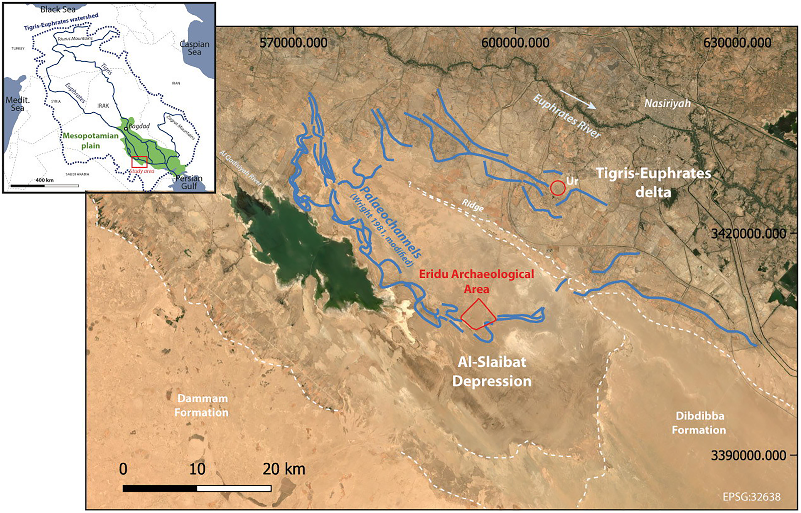

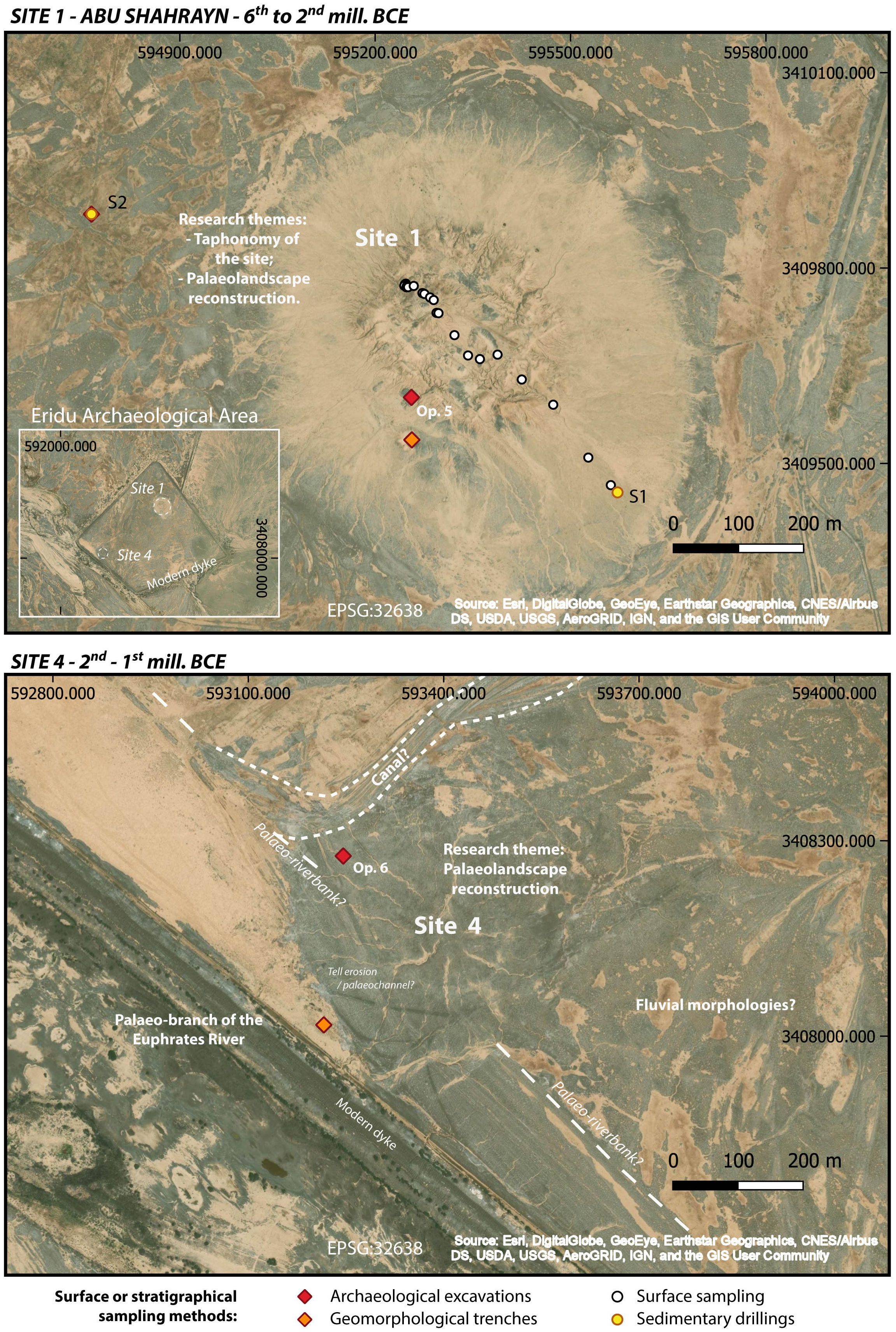
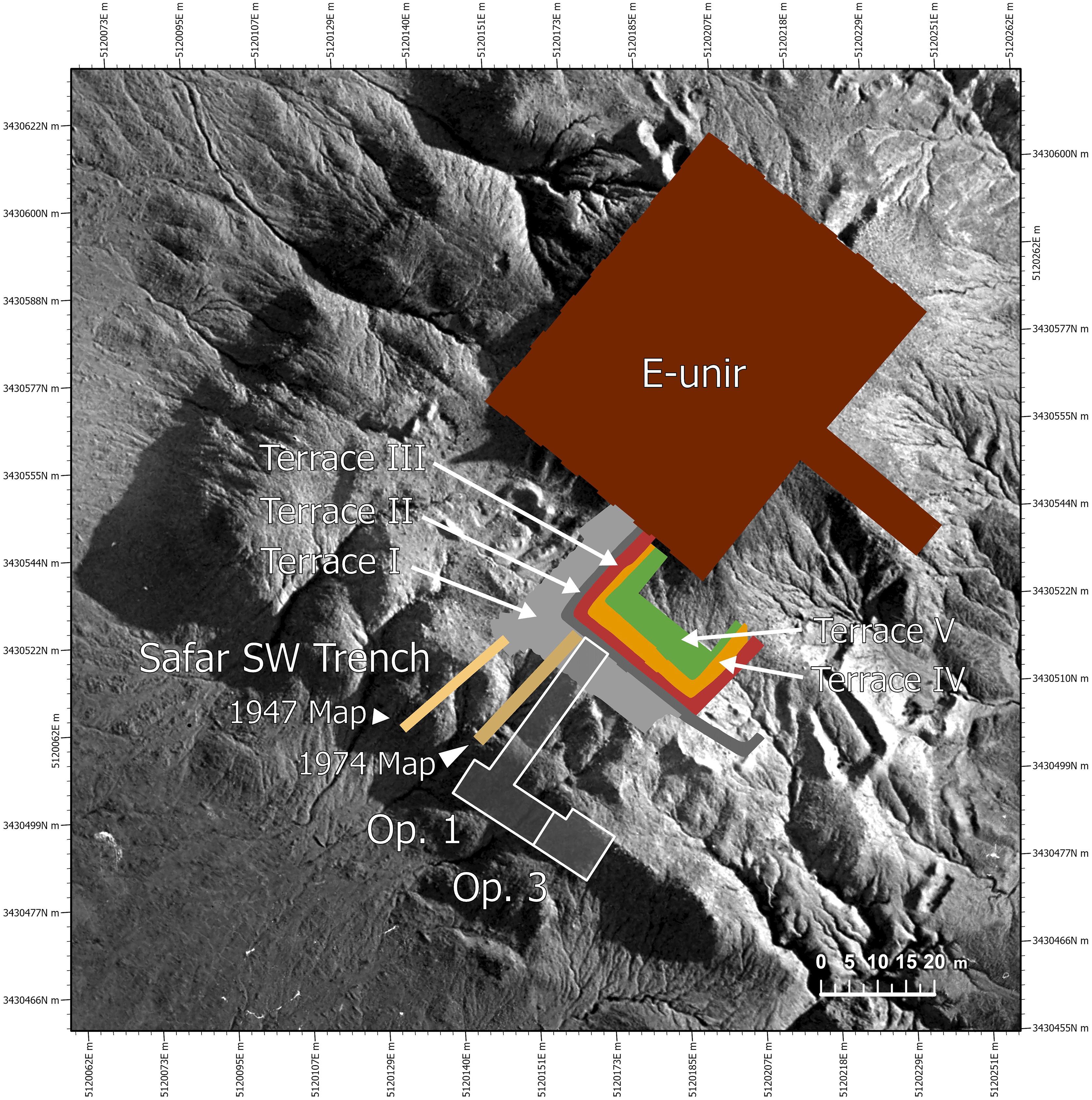
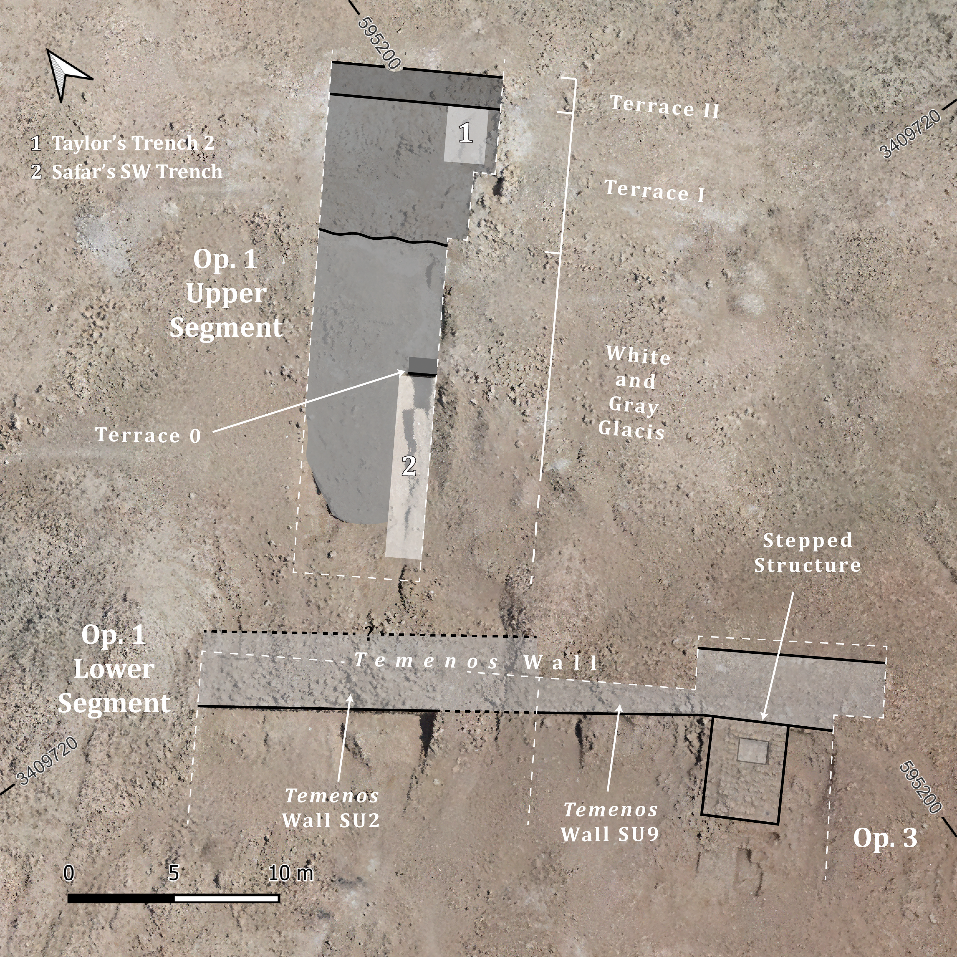
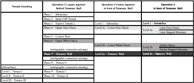
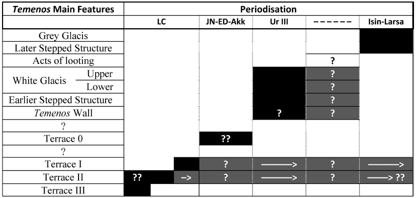
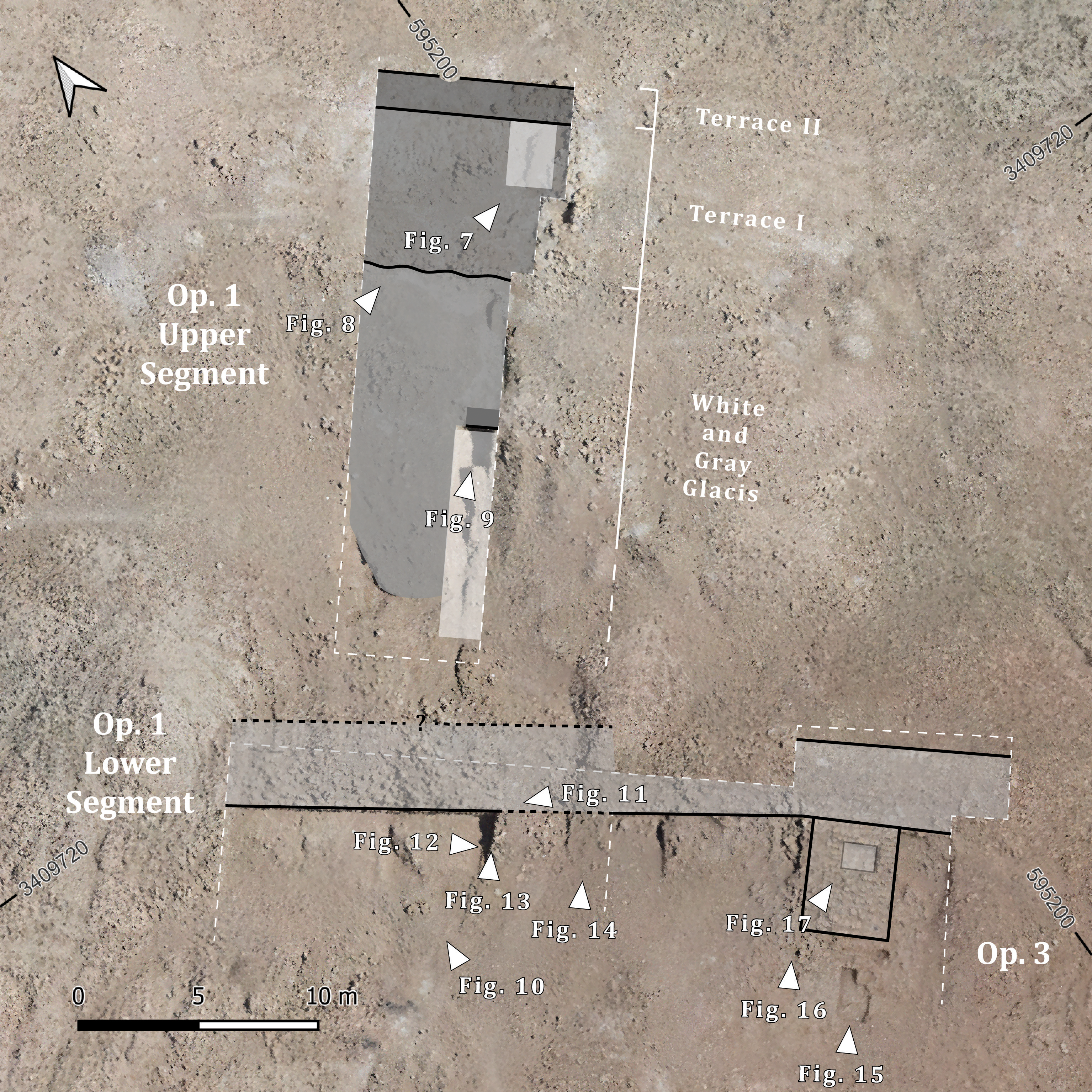
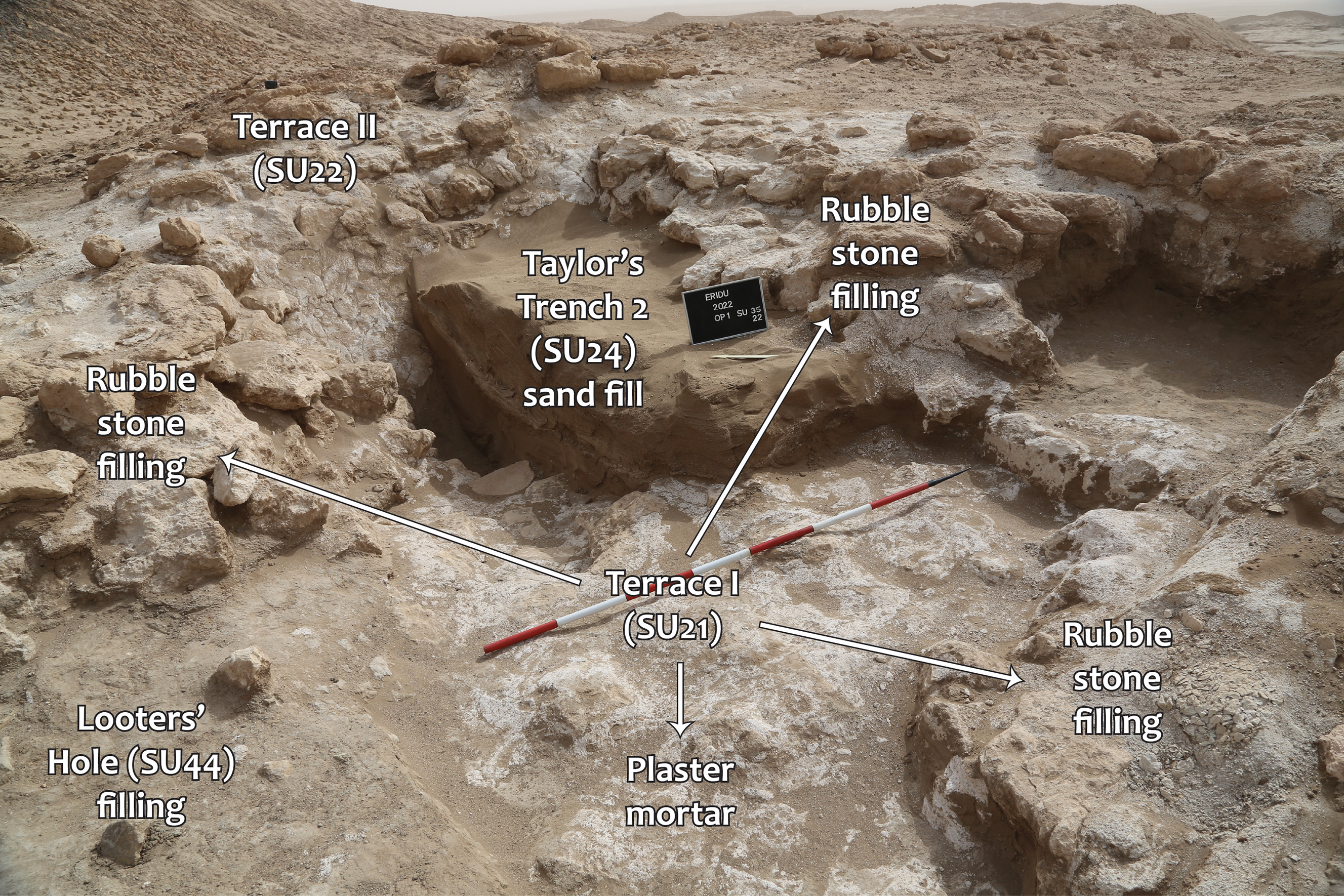
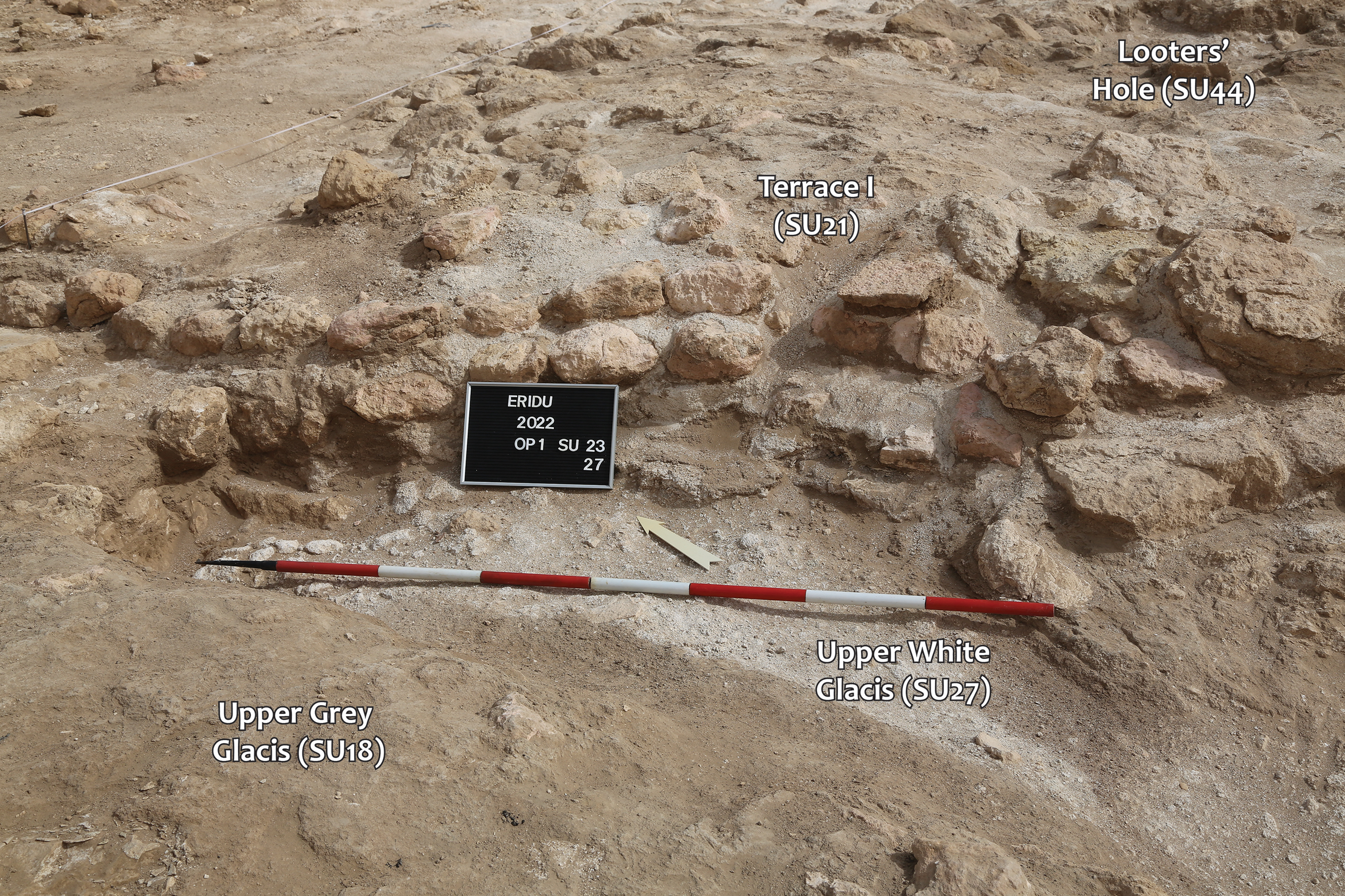
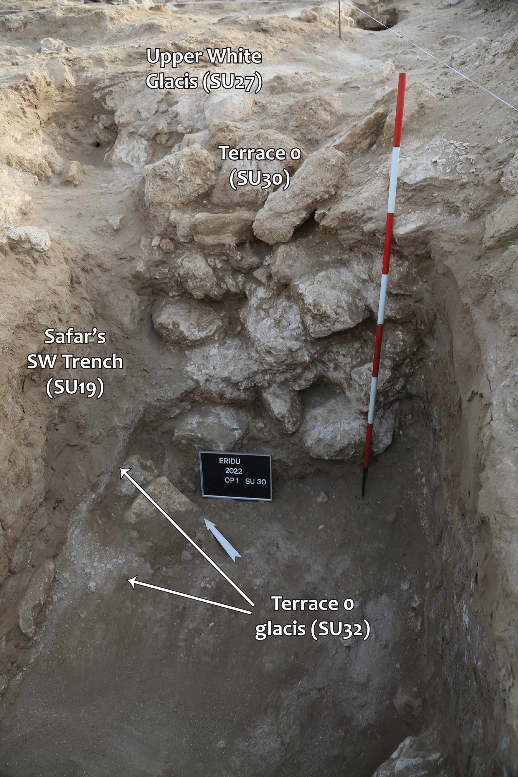
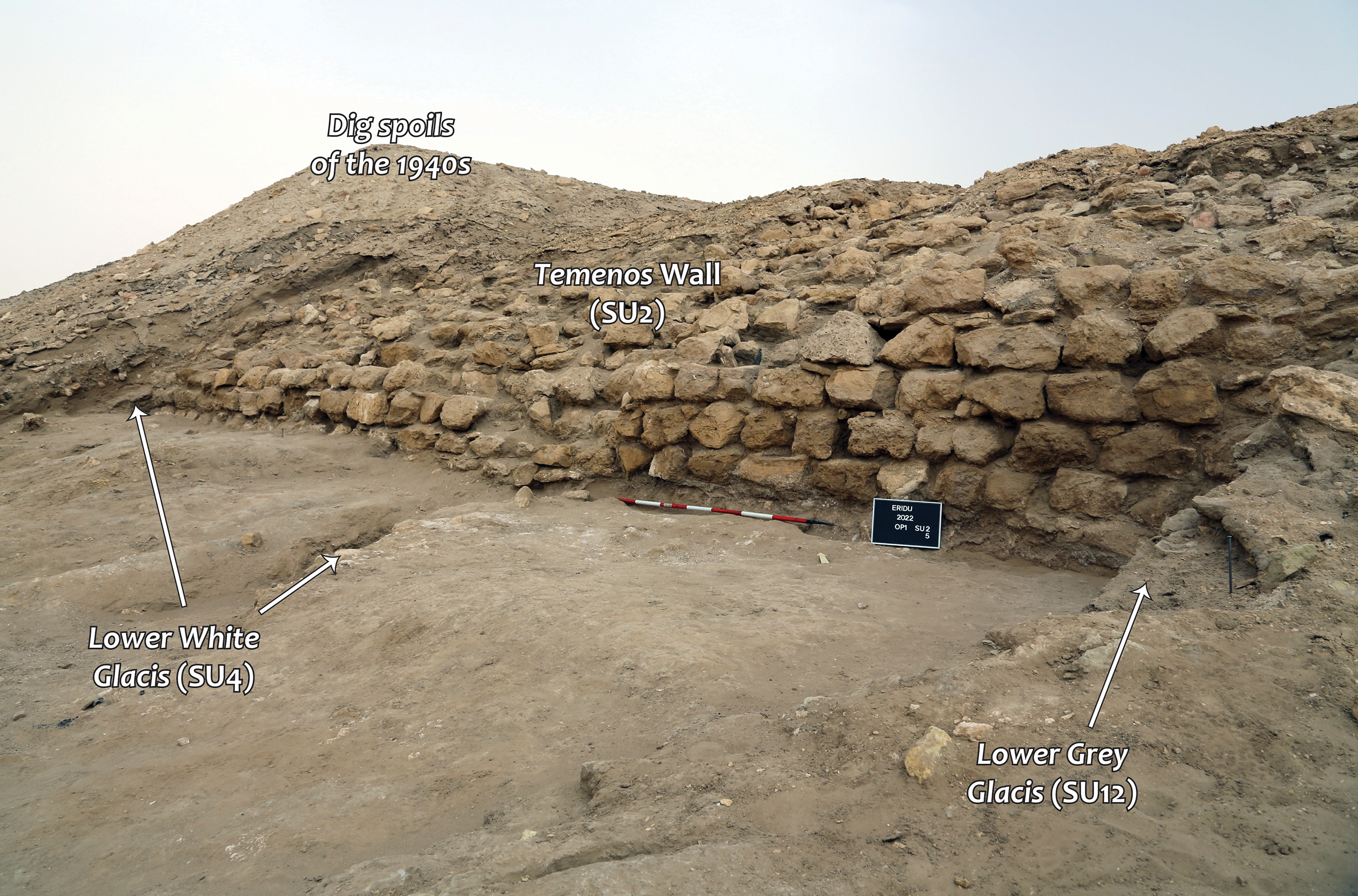
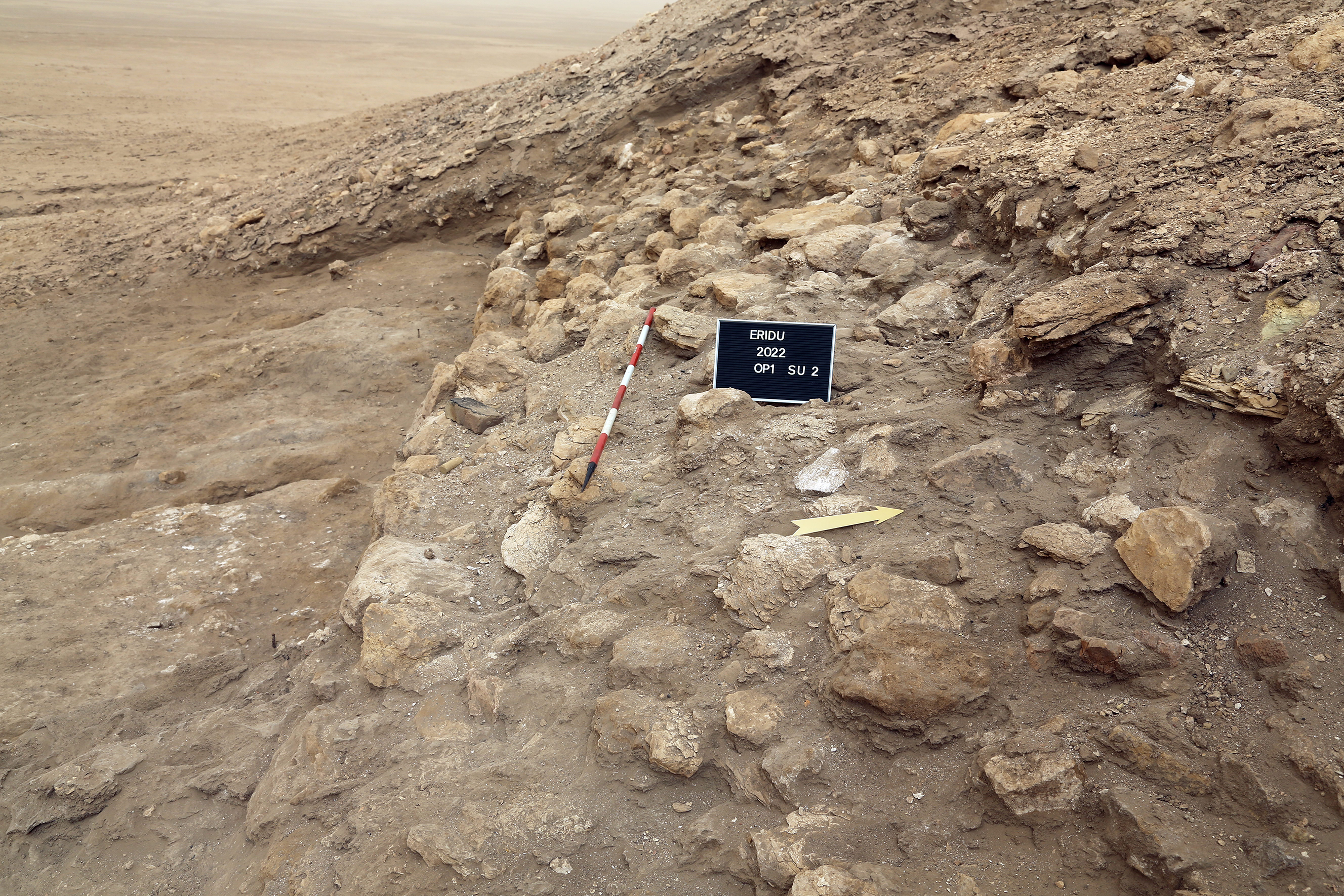
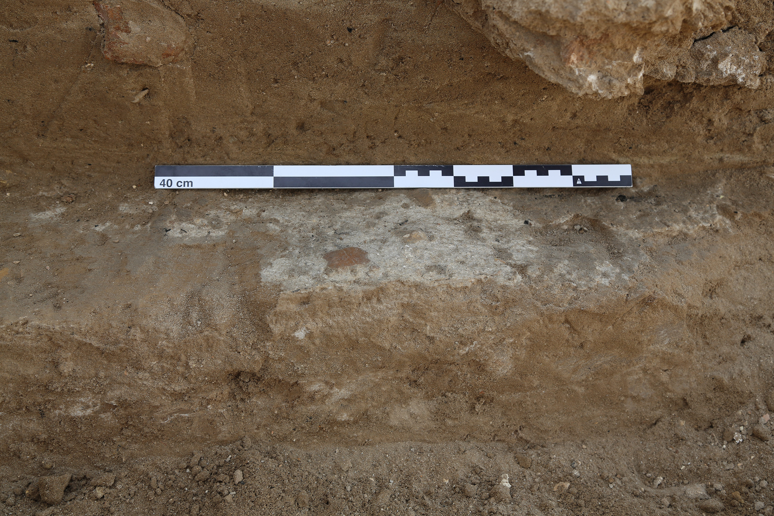
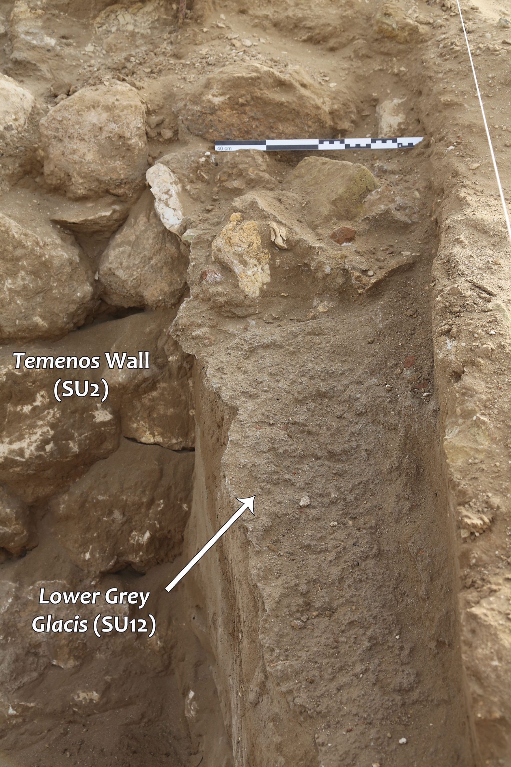
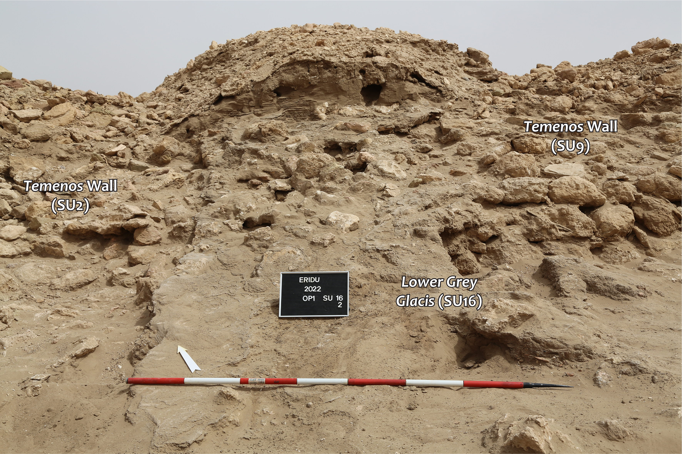
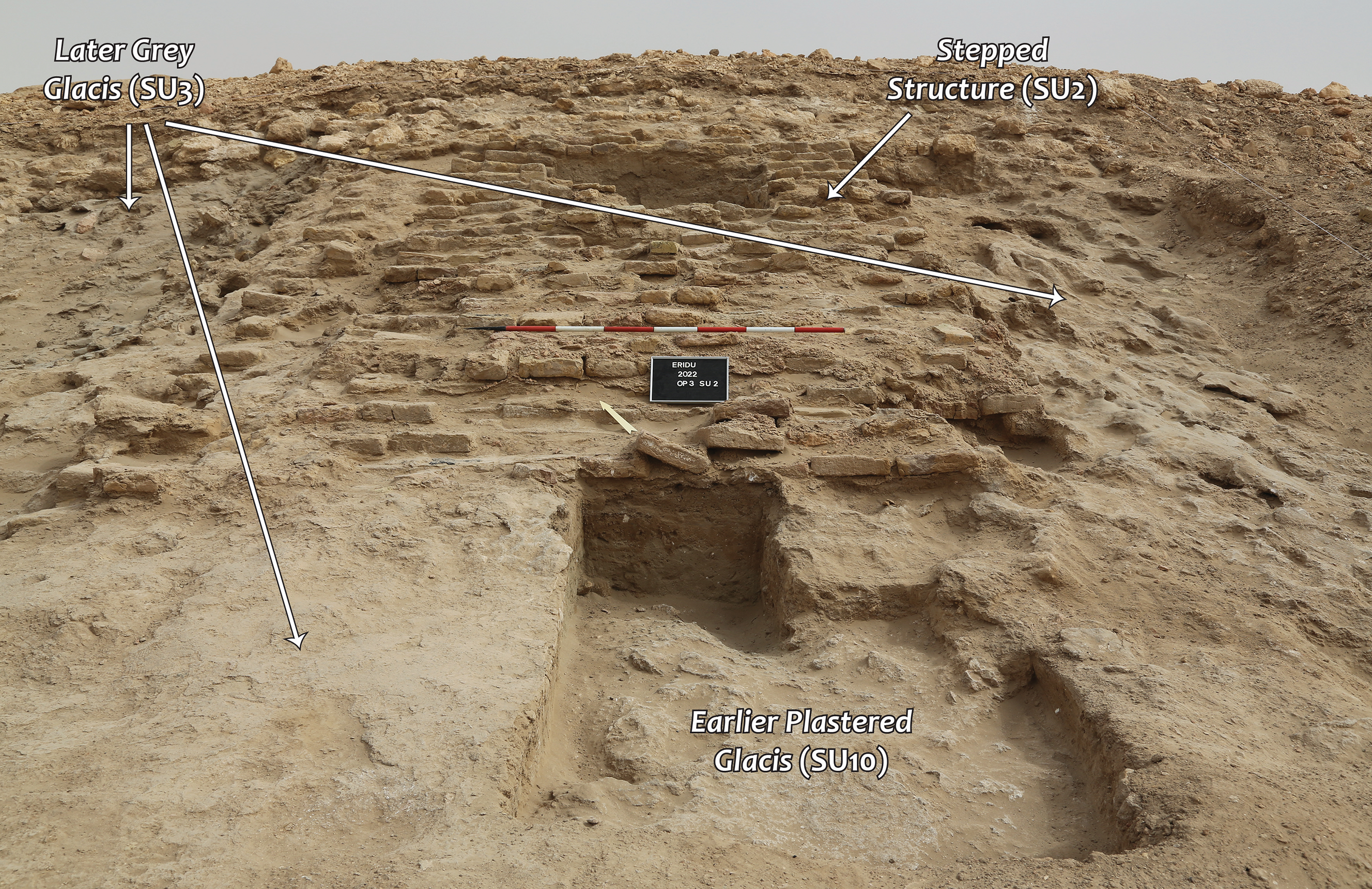
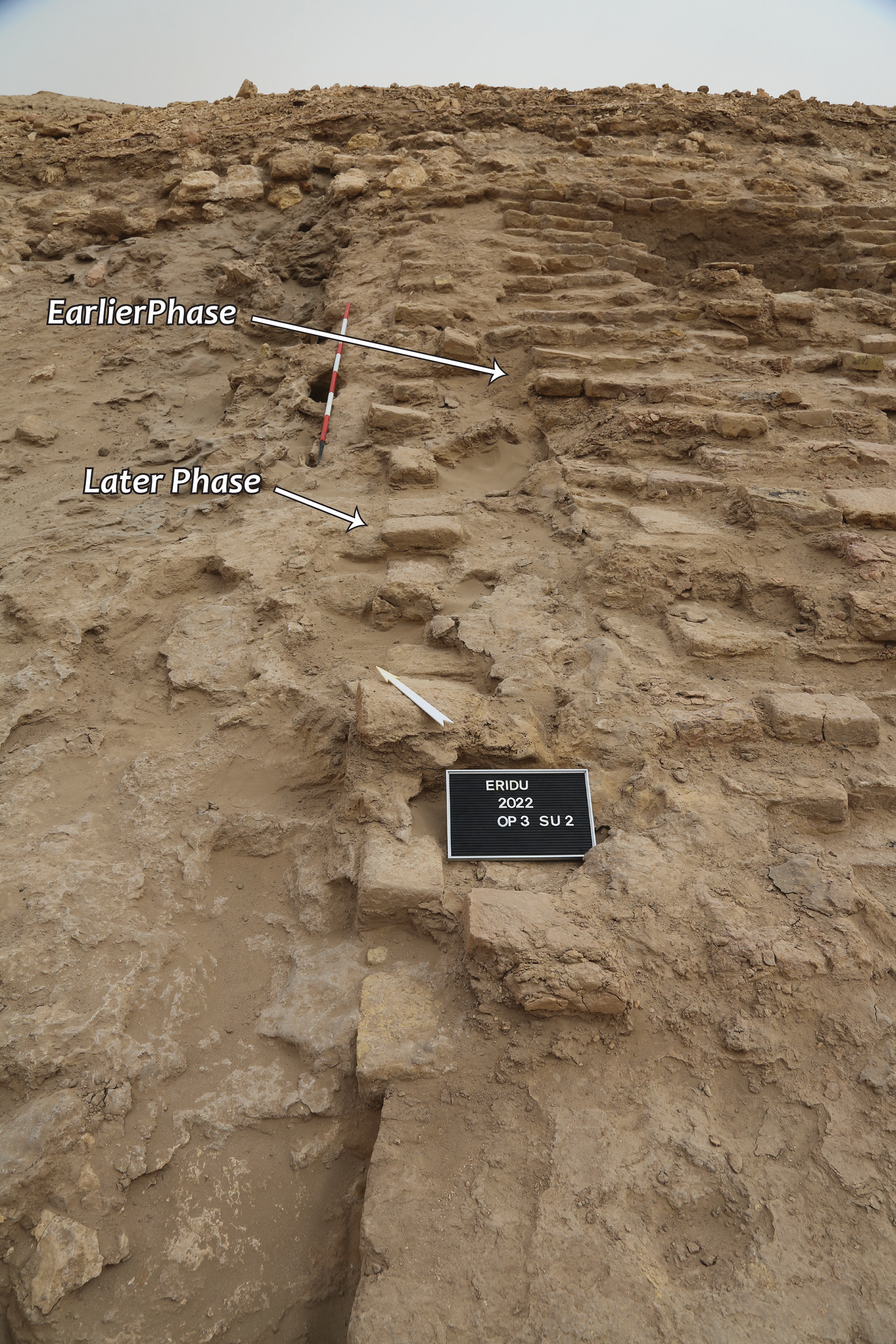
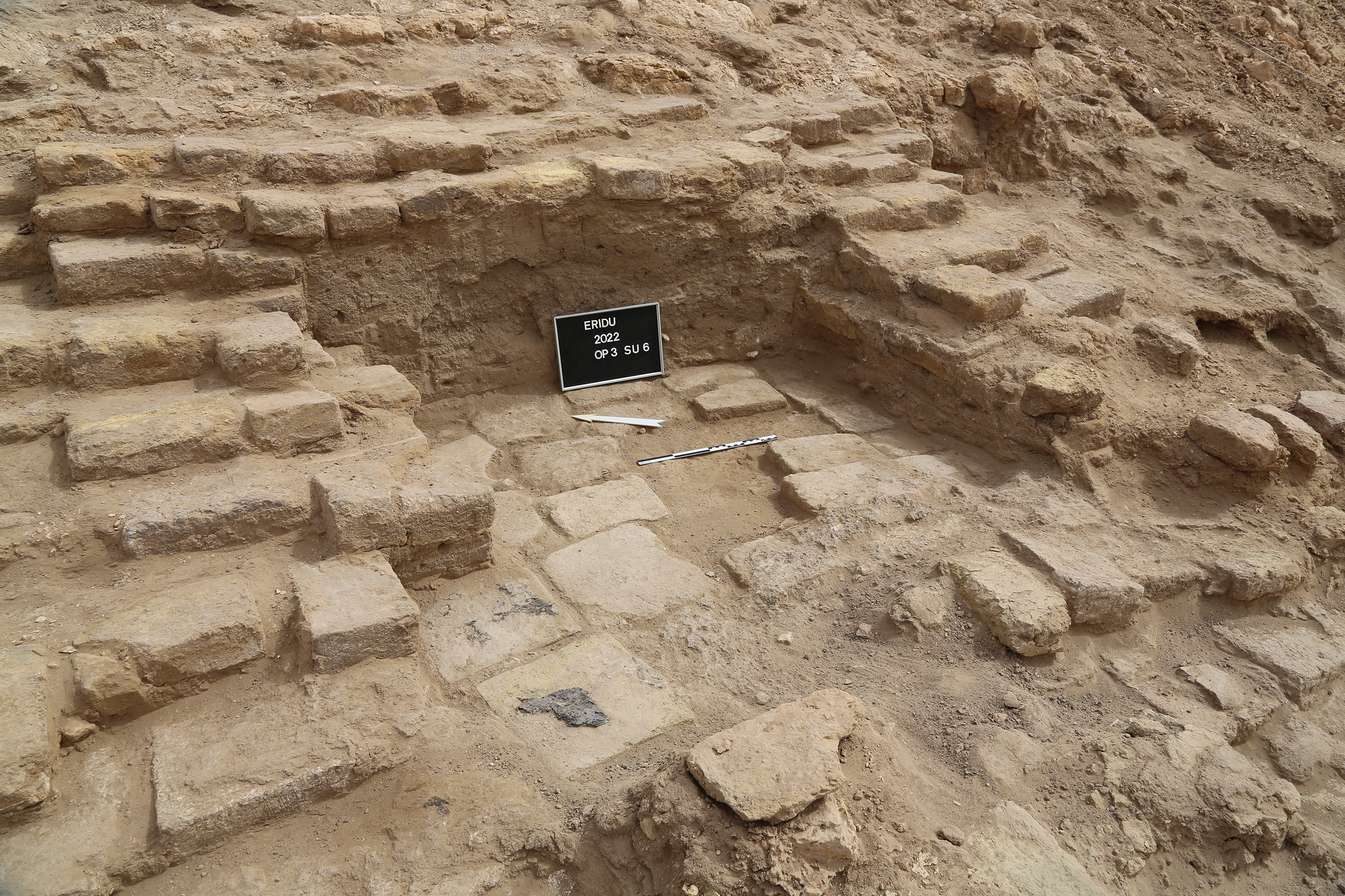
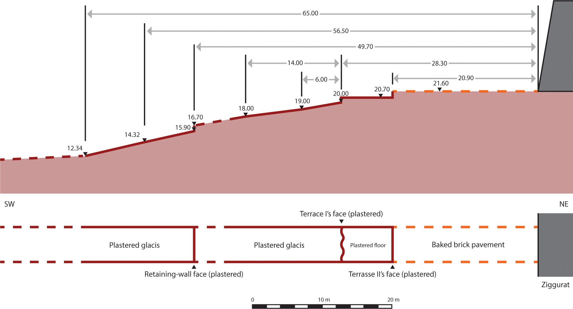
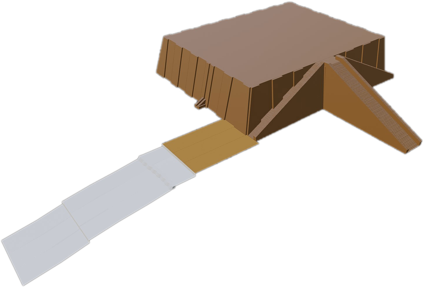


 Open access