


1. Introduction
The Ordovician rocks of the North Armorican Massif, along with equivalent strata in the other old massifs of the region (Fig. 1a and 1b), are widely accepted to record deposition in shallow seas on the flanks of an ocean bordering the northern margin of Gondwana. In recent years, most studies relate the Ordovician rock sequences of the European massifs to the opening of the Rheic Ocean (Linnemann et al. Reference Linnemann, Gerdes, Drost and Buschmann2007; Linnemann et al. Reference Linnemann, Pereira, Jeffries, Drost and Gerdes2008a, Reference Linnemann, D’Lemos, Drost, Jeffries, Gerdes, Romer, Samson, Strachan and McCann2008b; Nance & Linnemann, Reference Nance and Linnemann2008; Sanchez-Garcıa et al. Reference Sanchez-Garcıa, Bellido, Pereira, Chichorro, Quesada, Pin and Silva2010; Nance et al. Reference Nance, Gutiérrez-Alonso, Keppie, Linnemann, Murphy, Quesada, Strachan and Woodcock2012; Gutiérrez-Marco et al. Reference Gutiérrez-Marco, Piçarra, Meireles, Cózar, García-Bellido, Pereira, Vaz, Pereira, Lopes, Oliveira and Quesada2019; Dabard et al. Reference Dabard, Loi, Pavanetto, Meloni, Hauser, Matteini and Funedda2021; Syahputra et al. Reference Syahputra, Žák and Nance2022; Alvaro et al. Reference Álvaro, Sánchez-García and Casas2023). These works typically suggest Cambrian rifting was the precursor to ocean ridge incision with opening of the Rheic Ocean by the mid-Ordovician. However, in the Armorican Massif, not all workers agree with this model. Some favour a scenario, which envisions the opening of three oceans in the Ordovician, the Rheic, Conquet-Tepla and Medio-European (Faure et al. Reference Faure, Mézème, Duguet, Cartier and Talbot2005; Ballèvre et al. Reference Ballèvre, Bosse, Ducassou and Pitra2009; Ballèvre et al. Reference Ballèvre, Fourcade, Capdevila, Peucat, Cocherie and Fanning2012; Faure & Ferrièr, Reference Faure and Ferrière2022). Furthermore, regardless of the preferred model, many authors view the rift-drift phase of ocean development, to have occurred entirely within the Ordovician (Brun et al. Reference Brun, Ballard and Le Corre1991; Robardet et al. Reference Robardet, Bonjour, Paris, Morzadec and Racheboeuf1994; Ballèvre et al. Reference Ballèvre, Fourcade, Capdevila, Peucat, Cocherie and Fanning2012; Dabard et al. Reference Dabard, Loi, Pavanetto, Meloni, Hauser, Matteini and Funedda2021; LeFebrevre, Reference LeFebvre, Álvaro, Casas, Ghienne, Herbosch, Loi, Monceret, Verniers, Vidal, Vizcaïno and Servais2023).
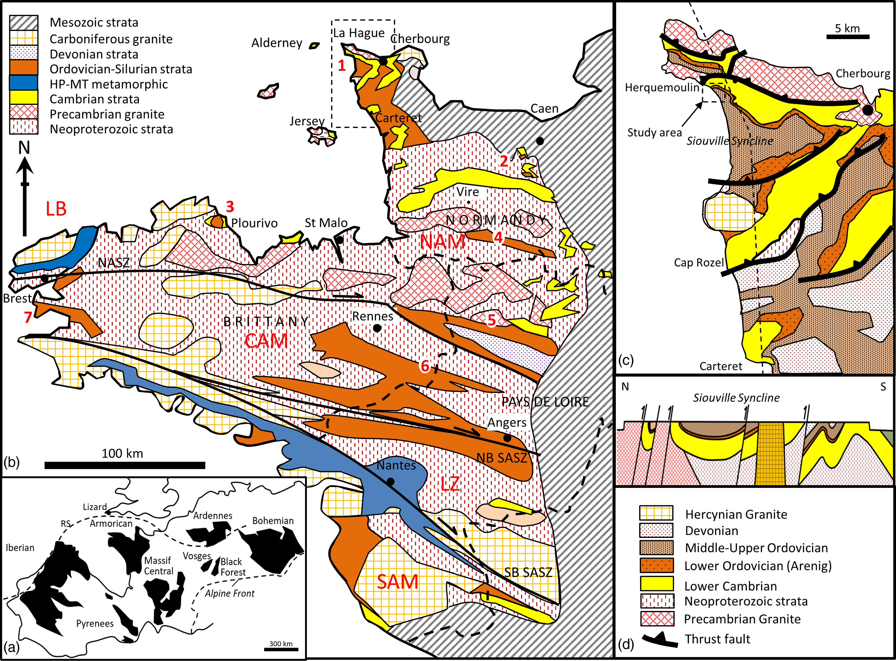
Location of study area and geological setting: (a) location of the Armorican Massif relative to others in Europe, RS = Rheic suture, (b) geological map of the Armorican Massif showing the location of the study area in La Hague, northern Cotentin Peninsula. The Armorican Massif is subdivided into five main domains separated by shear zones. These are the North Armorican Massif (NAM), the Leon Block (LB), the Central Armorican Massif (CAM), the Ligerian Zone (LZ) and the South Armorican Massif (SAM). The principal dividing faults are the north and south Armorican Shear Zones (NASZ and SASZ). The latter has a northern branch (NB SASZ) and southern branch (SB SASZ) which defines the Ligerian Zone of the South Armorican Massif. The main localities with exposures of Ordovician strata of interest are 1. La Hague, 2. May-sur-Orne, 3. Plourivo, 4. Domfront, 5. Laval, 6. Martigné-Ferchaud and 7. Crozon, (c) map of the Siouville syncline and location of Herquemoulin on its northern flank, (d) N-S geological cross-section (dashed line in c) showing the Variscan fold and thrust belt with the Palaeozoic strata largely preserved in synclines between Precambrian rocks.

The main purpose of this study is to combine detailed field evidence from the northern Cotentin Peninsula (Fig. 1c) with previously published regional data, to build a stratigraphic model for the Ordovician which characterizes basin development in the North Armorican Massif and which ultimately aims to assist interpretation of crustal development in the region.
Field evidence supports the idea that the Cambrian-Ordovician unconformity is a break-up unconformity and that it formed from regional upwarping in the late Cambrian to early Ordovician, following a period of early-middle Cambrian rifting. The strata overlying the unconformity are the Dapingian age Grès Armoricain Formation. It is relatively thin (0–94 m) in the North Armorican Massif and tapers irregularly to the north, interpreted to reflect passive onlap onto residual relief associated with the preceding uplift. It is interpreted to represent the initial phase of sedimentation associated with the onset of thermal subsidence of the margin. The succeeding Ordovician strata conversely display a steady thickening to the north (161–620 m), suggesting that from the Darriwilian onward, an ocean basin to the north was fully open and firmly established as the main locus of subsidence and sedimentation on the continental margin.
2. Geological setting
The Armorican Massif is a region of NW France formed of Precambrian and Palaeozoic rocks (Fig. 1a and b). The rocks and structure of the Armorican Massif were largely generated through processes related to three major geotectonic events: 1) the late Precambrian Cadomian Orogeny, 2) the subsequent early Palaeozoic opening of one or more oceans on the northern margin of Gondwana and 3) the closing of oceans, culminating in the Carboniferous Variscan Orogeny (D’Lemos et al. Reference D’Lemos, Strachan, Topley, D’Lemos, Strachan and Topley1990; Linnemann et al. Reference Linnemann, Gerdes, Drost and Buschmann2007; Linnemann et al. Reference Linnemann, Pereira, Jeffries, Drost and Gerdes2008a, Franke, Reference Franke2006, Reference Franke2023; Murphy & Nance, Reference Murphy and Nance2013).
The North Armorican Massif is dominated by Precambrian rocks and structures formed during the Cadomian Orogeny. These rocks include relics of ancient (2 Ga) high-grade metamorphic basement, known as the Icartian, granitoid intrusions, and a deformed cover of Neoproterozoic sedimentary rocks and volcanic strata (termed the Brioverian). The intrusions, volcanics and flysch-like sediments are interpreted to have been formed at a destructive plate boundary in the late Precambrian between 750 and 540 Ma. Multiple tectono-magmatic events affected the region during this time with pronounced episodes of magmatism and metamorphism occurring at the margin between 660–600 and 580–540 Ma (Dissler et al. Reference Dissler, Dore, Dupret, Gresselin and Le Gall1988; Brown et al. Reference Brown, Power, Topley, D’Lemos, D’Lemos, Strachan and Topley1990; Guerrot & Peucat, Reference Guerrot and Peucat1990; Ballèvre et al. Reference Ballèvre, Le Goff and Hébert2001; Chantraine et al. Reference Chantraine, Egal, Thiéblemont, Le Goff, Guerrot, Ballèvre and Guennoc2001). The repeated episodes of magmatism (plutonism and volcanism) and deformation/metamorphism resulted in the development of a foliation in many early magmatic rocks and tight folding of the Precambrian strata. The end of the Cadomian orogeny is dated to 540 Ma (Pasteels & Doré, Reference Pasteels, Doré and Odin1982; Peucat, Reference Peucat1986).
Erosion and collapse of the Cadomian uplands subsequently followed, resulting in deposition of Lower Cambrian red beds and shallow marine strata in extensional rift basins extending from the Cotentin to the Pays de la Loire (Doré et al. Reference Doré, Juignet, Larsonneur, Pareyn and Rioult1977; Went & Andrews, Reference Went and Andrews1990; Doré, Reference Doré, Chantraine, Rolet, Santallier, Piqué and Keppie1994; Went, Reference Went2021). The Cambrian strata comprise a mixture of clastic and carbonate rocks with scarce body fossils of early Cambrian age. In the Pays de la Loire area, the sedimentary rocks are intercalated with felsic volcanics, predominantly ashes and ignimbrites but also some andesitic lavas (Le Gall, Reference Le Gall1995). The middle and upper Cambrian is typically absent, consistent with there being a period of broad regional uplift or epeirogenesis prior to deposition of the overlying Ordovician (Doré, Reference Doré1972; Doré et al. Reference Doré, Juignet, Larsonneur, Pareyn and Rioult1977). In the North Armorican Massif, this phase of uplift is referred to as the Norman gap. It is part of a widespread event extending at least from Morocco, through Iberia to Normandy, where it is known as the Toledanian uplift (Alvaro et al. Reference Álvaro, Casas, Clausen and Quesada2018; Alvaro et al. Reference Álvaro, Sánchez-García and Casas2023). It is an event that was associated with bimodal (basic-felsic) plutonism and volcanism (e.g. Miller et al. Reference Miller, Samson and D’Lemos2001). This thermal event is interpreted to relate to crustal processes active in the development and emergence of a passive margin on the northern flank of Gondwana in the Ordovician (Sanchez-Garcia et al. Reference Sanchez-Garcıa, Bellido, Pereira, Chichorro, Quesada, Pin and Silva2010; Esedo et al. Reference Esedo, van Wijk, Coblentz and Meyer2012; Alvaro et al. Reference Álvaro, Casas, Clausen and Quesada2018; Alvaro et al. Reference Álvaro, Sánchez-García and Casas2023).
Middle and Upper Ordovician strata are widespread over both Normandy and Brittany. Their deposition is interpreted to reflect a sustained period of renewed subsidence and marine transgression associated with the newly created passive margin (Paris & Robardet, Reference Paris and Robardet1990; Ballèvere et al. Reference Ballèvre, Le Goff and Hébert2001; Nysaether et al. Reference Nysæther, Torsvik, Feist, Walderhaug and Eide2002; Murphy et al. Reference Murphy, Gutierrez-Alonso, Nance, Fernandez-Suarez, Keppie, Quesada, Strachan and Dostal2006; Nance et al. Reference Nance, Gutiérrez-Alonso, Keppie, Linnemann, Murphy, Quesada, Strachan and Woodcock2010, Reference Nance, Gutiérrez-Alonso, Keppie, Linnemann, Murphy, Quesada, Strachan and Woodcock2012; Murphy & Nance, Reference Murphy and Nance2013; Alvaro et al. Reference Álvaro, Sánchez-García and Casas2023). Volcanic rocks are locally associated with the Ordovician strata. In the North Armorican Massif, at Plourivo-Plouezec, basaltic andesite lavas dated as late Floian age, but possibly Toledanian in origin, are developed between Cambrian red beds and Ordovician sandstones (Auvray et al. Reference Auvray, Macé, Vidal and Vander Voo1980; Galerne et al. Reference Galerne, Caroff, Rolet and Le Gall2006; Went, Reference Went2017). At Crozon, in the Central Armorican Massif, basalts occur interbedded with shallow marine clastic strata at multiple levels throughout the Ordovician (Caroff et al. Reference Caroff, Vidal, Bénard and Darboux2009). In the South Armorican Massif, felsic volcanic rocks form part of the high-pressure/medium temperature porphyroid nappe (Ballèvere et al. Reference Ballèvre, Fourcade, Capdevila, Peucat, Cocherie and Fanning2012). In the North Armorican Massif, Silurian and Devonian strata succeed the Ordovician strata and record continued deposition on a shallow marine shelf.
The latest of the key events, the Variscan Orogeny, was a collisional orogeny with significant late-stage, crustal-scale wrench faulting with up to 4000 km of dextral shear (Franke, Reference Franke2006; Hynes & Johnston, Reference Hynes and Johnston2023). The late dextral shear resulted in the formation of the North and South Armorican Shear Zones, which juxtapose the crustal units of the North Armorican Massif, the Central Armorican Massif and the South Armorican Massif. Spurs from these faults zones further isolate the Leon Block (LB) and the Ligerian Zone (LZ) (Fig. 1b). The Leon Block and the South Armorican Massif both contain high-pressure, medium temperature metamorphic rocks (amphibolite, eclogite, migmatite) that have been interpreted as ophiolites, leading to the proposal of the former presence of the Le Conquet-Tepla and Medio-European oceans (Ballèvre et al. Reference Ballèvre, Fourcade, Capdevila, Peucat, Cocherie and Fanning2012; Faure & Ferrier, Reference Faure and Ferrière2022). The presence or scale of these additional oceans, however, is disputed, with a suggestion these may have been embryonic oceans or extended rifts (Chenin et al. Reference Chenin, Picazo, Jammes, Manatschal, Müntener and Karner2019). One of the main contra-indications to full ocean development is the very close affinity of the macrofauna and palynomorphs (including chitinozoa) of the Armorican Massif with equivalent strata in the Sahara (Robardet, Reference Robardet2003; Videt et al. Reference Videt, Paris, Rubino, Boumendjel, Dabard, Loi, Ghienne, Marante and Gorini2010). A second is the provenance of Ordovician sediment and zircon populations which place the Central Armorican Massif adjacent to the Saharan craton and Arabian Nubian shield (Noblet & LeFort, Reference Noblet and LeFort1990; Linnemann et al. Reference Linnemann, McNaughton, Romer, Gehmlich, Drost and Tonk2004; Dabard et al. Reference Dabard, Loi, Pavanetto, Meloni, Hauser, Matteini and Funedda2021). A third is the consistently rich Uranium content of early Silurian black shales which relate to a contiguous glaciated shelf on the southern flank of the Rheic Ocean in the Hirnantian (Romer & Kroner, Reference Romer and Kroner2019). Together they support a model of very limited (if any) separation of the Armorican Massif from the main Gondwana landmass (McKerrow et al. Reference McKerrow, Mac Niocaill, Ahlberg, Clayton, Cleal and Eagar2000). Evidence of Armorican provenance for the Devonian melange deposits below the Lizard Ophiolite in the UK has been used to suggest direct collision and obduction of the Armorican plate with the Avalonian plate at the Rheic suture (Strachan et al. Reference Strachan, Linnemann, Jeffries, Drost and Ulrich2014). Models for the closure of the Rheic Ocean, including challenges to the origin of the Devonian melange and the origin of the rocks of the Leon block, continue to be presented, as the search for an improved understanding of the Variscan orogeny continues (Franke, Reference Franke2023). Clearly, geotectonic uncertainties remain; it is hoped the data presented in this study will help contribute to a resolution of the apparent contradictions presented by different datasets.
Throughout the Armorican Massif, Palaeozoic strata are deformed into typically south-verging folds and thrusts (Fig. 1c). Together, these accommodate around 30% of crustal shortening (Le Gall et al. Reference Le Gall, Authemayou, Graindorge, Duperret, Kaci, Ehrhold and Schmitt2021). The amount of dextral shearing on the North and South Armorican Shear Zones is disputed. Some authors have considered the amount of shearing on the North Armorican Shear Zone to be modest, the order of 0–100 km (e.g. Gumiaux et al. Reference Gumiaux, Gapais, Brun, Chantraine and Ruffet2004), whereas others suggest much larger displacements of several hundred km (e.g. Hynes & Johnston, Reference Hynes and Johnston2023). Although the geology is superficially similar across the shear zones, there are some significant differences which would appear to support larger displacements (many 100’s to 1000’s km). They include sharp changes in sediment thickness (this study) indicating more than 300 km lateral displacement, and detrital zircon studies which point to separate source areas for the Ordovician of the Central and North Armorican Massifs (Dabard et al. Reference Dabard, Loi, Pavanetto, Meloni, Hauser, Matteini and Funedda2021). These data highlight that the Central Armorican Massif and North Armorican Massif were not contiguous blocks in the Ordovician, and moreover, they were likely to have been separated by many 100’s to 1000’ km (Lefebvre et al. Reference LeFebvre, Álvaro, Casas, Ghienne, Herbosch, Loi, Monceret, Verniers, Vidal, Vizcaïno and Servais2023). For this reason, the current study restricts interpretation of the Cambrian and Ordovician strata to those rocks of the North Armorican Massif. Some data from the Central Armorican Massif are included on maps and sections, primarily to illustrate the marked differences in the geology (e.g. sediment thickness), across the North Armorican Shear Zone.
Present levels of erosion have resulted in the Cambrian, Ordovician and succeeding Palaeozoic strata typically being preserved in synclines formed by the Carboniferous folding, with the synclines separated by belts of Precambrian basement. This includes the Siouville syncline, the focus of field work in this study (Fig. 1c and 1d). At the eastern margin of the Armorican Massif, the effects of the Variscan Orogeny are manifest in an angular unconformity between steeply dipping Palaeozoic and gently dipping Mesozoic strata (Fig. 1b).
3. Previous work
The Cambrian sedimentary rocks of the North Armorican Massif (Channel Islands, Normandy and Brittany) are typically texturally and compositionally immature (highly feldspathic) and derived from local, tectonically rejuvenated uplands (Went, Reference Went2005, Reference Went2017, Reference Went2020, Reference Went2021; Went & McMahon, Reference Went and McMahon2018). Facies changes occur over relatively short distances (km-10’s km) highlighting that deposition occurred in relatively small rift basins. Palaeontological age constraints reported in Doré (Reference Doré, Chantraine, Rolet, Santallier, Piqué and Keppie1994) combined with new observations reported in Went (Reference Went2017) and McMahon et al. (Reference McMahon, Davies, Liu and Went2022) have resulted in a regional sequence stratigraphic correlation of outcrops and linked depositional systems tracts which provide the foundation on which to evaluate the relationship of the Cambrian to the Ordovician in the North Armorican Massif (Went Reference Went2021).
In stark contrast to the Cambrian, Ordovician strata are typically texturally and compositionally mature, reflecting their derivation from distant source areas on the Gondwanan continent to the south (Noblet & LeFort, Reference Noblet and LeFort1990; Dabard et al. Reference Dabard, Loi, Pavanetto, Meloni, Hauser, Matteini and Funedda2021). The basal Ordovician stratum is typically the Armorican Quartzite or Grès Armoricain Formation, of Floian-Dapingian (Arenig) age. In the Central Armorican Massif, the Grès Armoricain Formation is locally preceded by laterally impersistent, trace fossil-bearing strata termed the initial red beds (Ballard et al. Reference Ballard, Brun and Durand1986; Bonjour, Reference Bonjour1989; Dabard & Simon, Reference Dabard and Simon2011). The lithostratigraphy and chronostratigraphy of the Ordovician of the Armorican Massif is summarized in Robardet et al. (Reference Robardet, Bonjour, Paris, Morzadec and Racheboeuf1994), Paris et al. (Reference Paris, Robardet, Dabard, Feist, Ghienne, Guillocheau, Le Hérissé, Loi, Mlou, Servais and Shergold1999); Vidal et al. (Reference Vidal, Dabard, Gourvennec, Le Hérissé, Loi, Paris, Plusquellec and Racheboeuf2011).
The lateral extent of quartzites similar in age and facies to the Grès Armoricain is impressively wide, with outcrops present in the Iberian Peninsula (Gutiérrez-Alonzo et al. Reference Gutiérrez-Alonso, Fernández-Suárez, Gutiérrez-Marco, Corfu, Murphy and Suárez2007), Bohemia (Linnemann et al. Reference Linnemann, Pereira, Jeffries, Drost and Gerdes2008a), the Balkans (Žák et al. Reference Žák, Svojtka, Gerdjikov, Vangelov, Kounov, Sláma and Kachlík2023), North Africa (Noblet & Lefort, Reference Noblet and LeFort1990) and possibly as far east as Afghanistan (Noblet & Lefort, Reference Noblet and LeFort1990; Hynes & Johnston, Reference Hynes and Johnston2023). The lateral extent of the Arenig quartzites together with their consistent array of shallow marine trace fossils has been used to suggest deposition took place on a wide marine shelf (Durand, Reference Durand1985; Durand & Noblet, Reference Durand and Noblet1986; Dabard et al. Reference Dabard, Loi and Paris2007).
A difference of opinion exists over the age of red beds of the Port Lazo and Roche Jagu Formations at Plourivo-Brehec in the North Armorican Massif (Fig. 1b). Suire et al. (Reference Suire, Dabard and Chauvel1991), Robardet et al. (Reference Robardet, Bonjour, Paris, Morzadec and Racheboeuf1994) and Egal et al. (Reference Egal, Le Goff, Guennoc, LeBret, Thiéblemont, Hallégouët, Houlgatte, Callier and Cairn1995) assign the red beds an early Ordovician age by comparison with the initial red beds seen in Crozon (in the Central Armorican Massif), whereas Went (Reference Went2017, Reference Went2021), McMahon et al. (Reference McMahon, Davies and Went2017), and McMahon et al. (Reference McMahon, Davies, Liu and Went2022) argue the rocks are of lower Cambrian affinity and correlate well with the Cambrian elsewhere in the North Armorican Massif.
4. Methods
The Ordovician, including the unconformity with the Cambrian, has been studied in detail in the field south of Herquemoulin Harbour, La Hague (Fig. 1b and 1c). Observations and data were recorded on maps, in photos and as sedimentary logs. Reconnaissance observations have additionally been made at Ecalgrain (La Hague), May-sur-Orne, Plourivo, Domfront and Crozon. This work is combined with published work on the palaeontology and lithostratigraphy of the Cambrian and Ordovician from other locations in the Armorican Massif, and beyond, as summarized in Doré (Reference Doré, Chantraine, Rolet, Santallier, Piqué and Keppie1994), Robardet et al. (Reference Robardet, Bonjour, Paris, Morzadec and Racheboeuf1994), Paris et al. (Reference Paris, Robardet, Dabard, Feist, Ghienne, Guillocheau, Le Hérissé, Loi, Mlou, Servais and Shergold1999), Videt et al. (Reference Videt, Paris, Rubino, Boumendjel, Dabard, Loi, Ghienne, Marante and Gorini2010), and Vidal et al. (Reference Vidal, Dabard, Gourvennec, Le Hérissé, Loi, Paris, Plusquellec and Racheboeuf2011), to provide a regional synthesis. Estimates of average subsidence rates for different time intervals are reported to compare sediment accumulation rates (m/Ma) in different locations. The values are simply sediment thickness divided by time and use the International Commission on Stratigraphy (ICS) time scale of 2021. No decompaction corrections are applied.
5. Structure and stratigraphy at Herquemoulin
5.a. Structure
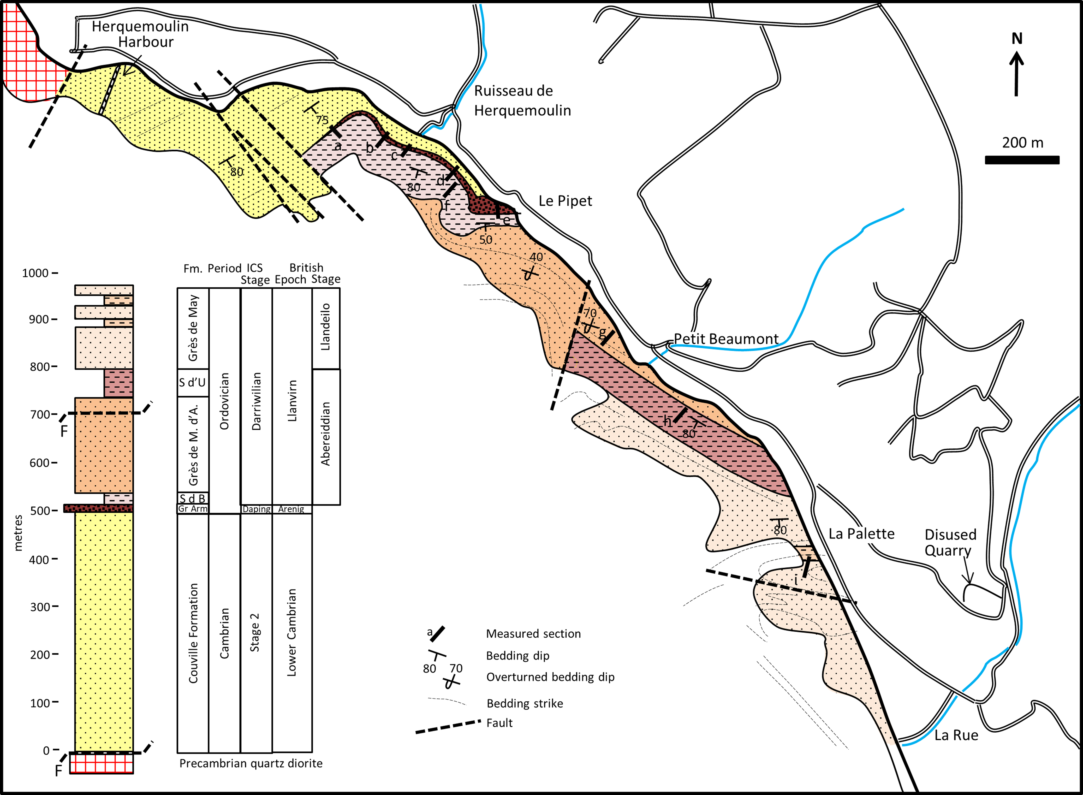
Approximately 1000 m of Cambrian and Ordovician strata are exposed on the foreshore between Herquemoulin and the Hamlet of La Rue (Fig. 2). The strata exposed form the northern limb of the westerly plunging, Siouville syncline. Thrust tightening of the syncline has resulted in oversteepening of the bedding such that it is subvertical to overturned through most of the study area (Dissler & Gresslin, Reference Dissler and Gresselin1988). The dip and strike of bedding is mostly simple, changing gradually. Locally, however, notably at Le Pipet, the strata exhibit tight, overturned parasitic folds.
Geological map of the main field area south of Herquemoulin Harbour, and place names mentioned in text. The geological column summarizes the age control established for the Cambrian and Ordovician strata. Gr Arm = Grès Armoricain, S d’U = Schistes d’Urville, M.d’A = Moitiers d’Allonne, S d B = Schistes de Beaumont.

5.b. Stratigraphy
The Cambrian plus five distinct units in the Ordovician are mapped in the study area (Fig. 2). The unconformity between the Cambrian and basal Ordovician is exposed south-east of Herquemoulin on the reefs opposite the Ruisseau de Herquemoulin (Fig. 2). The Cambrian feldspathic sandstones are termed the Couville Formation. These sandstones become more shaley on the southern limb of the syncline, where they are termed the Rozel or Carteret Formations, and contain sparse fossils indicating they are lower Cambrian (Stage 2) in age (Doré et al. Reference Doré, Juignet, Larsonneur, Pareyn and Rioult1977; Went, Reference Went2020). The basal Ordovician quartzitic sandstones are termed the Grès Armoricain Formation. These sandstones locally contain thin shales from which Chitinozoa indicate a Dapingian (middle Arenig) age (Robardet et al. Reference Robardet, Bonjour, Paris, Morzadec and Racheboeuf1994). The Grès Armoricain is succeeded in La Hague by the shale-dominated Schistes de Beaumont Formation. Body fossils confirm this is of Darriwilian (Llanvirn) age. The remainder of the section has typically remained undivided. However, correlations made in this study suggest the succeeding sandstone-dominated interval should be ascribed to the Grès de Moitiers d’Allonne Formation, as described from the Carteret area by Graindor et al. (Reference Graindor, Roblot, Robardet, Poncet, Lorenz and Lemarchand1976). Likewise, correlations to strata in Caen and Domfront suggest the 60 m thick shale that overlies the Grès de Moitiers d’Allonne Formation should be ascribed to the Early Darriwilian/Abereiddian Schistes d’Urville Formation (Paris et al. Reference Paris, Robardet, Dabard, Feist, Ghienne, Guillocheau, Le Hérissé, Loi, Mlou, Servais and Shergold1999). Sandstone-dominated sequences of late Darriwilian/Llandeilo age that post-date the Schistes d’Urville Formation are typically referred to as either the Mont de Besneville or Grès de May Formation (Graindor et al. Reference Graindor, Roblot, Robardet, Poncet, Lorenz and Lemarchand1976; Robardet et al. Reference Robardet, Bonjour, Paris, Morzadec and Racheboeuf1994; Vidal et al. Reference Vidal, Dabard, Gourvennec, Le Hérissé, Loi, Paris, Plusquellec and Racheboeuf2011). The latter term is used to describe the uppermost, sandstone-dominated interval in this study area. The characteristic features of each formation are outlined below.
5.c. Couville Formation – Lower Cambrian (Stage 2)
The Couville Formation is approximately 625 m thick. The uppermost 500 m of the formation is dominated by fine to medium-grained, feldspathic sandstones arranged in stacked upwards coarsening cycles, or parasequences, 8–10 m thick, interpreted as delta front deposits (Went, Reference Went2020). The bedding in the Cambrian is subparallel to the unconformity surface, locally showing a subtle discordance with the Ordovician.
5.d. Grès Armoricain Formation – (Dapingian/Middle Arenig)
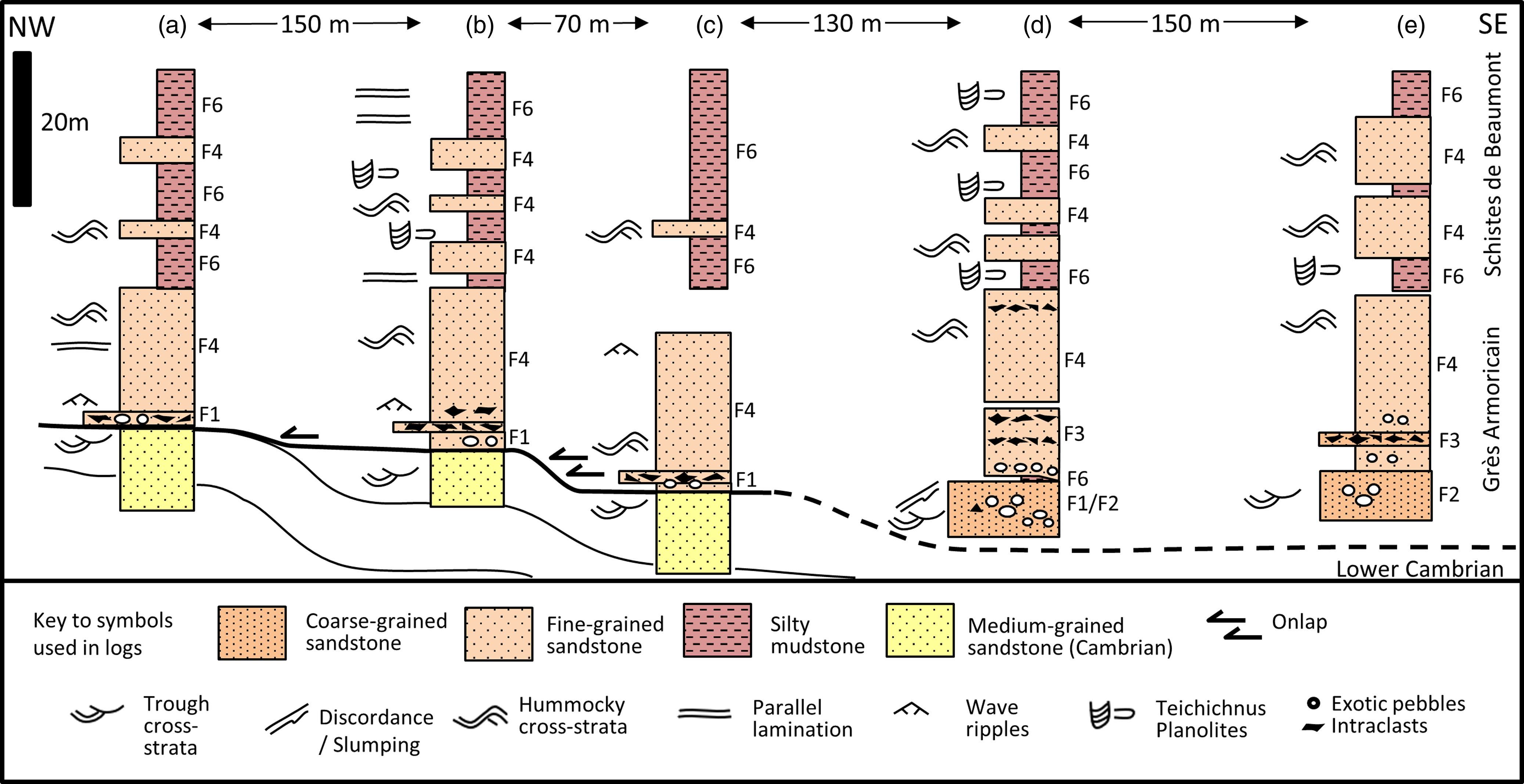
The Grès Armoricain is around 15 m thick and rests with a subtle discordance on the Couville Formation (Figs. 3–5). Beds of pebble conglomerate are common near the base of the Grès Armoricain. The formation is otherwise dominated by pale-coloured sandstone, with local, thin, discontinuous beds of grey shale. The Ordovician strata locally onlaps the Cambrian, suggesting gradual burial of relief present on the basin floor at the time of deposition (Fig. 4b).
Measured sections through the Cambrian and basal Ordovician at the unconformity. Note the onlapping of the Ordovician onto basin floor topography, the common concentrations of pebbles and intraformational clasts in beds at or near the unconformity, and the lateral variations in facies observed in the Grès Armoricain Formation.

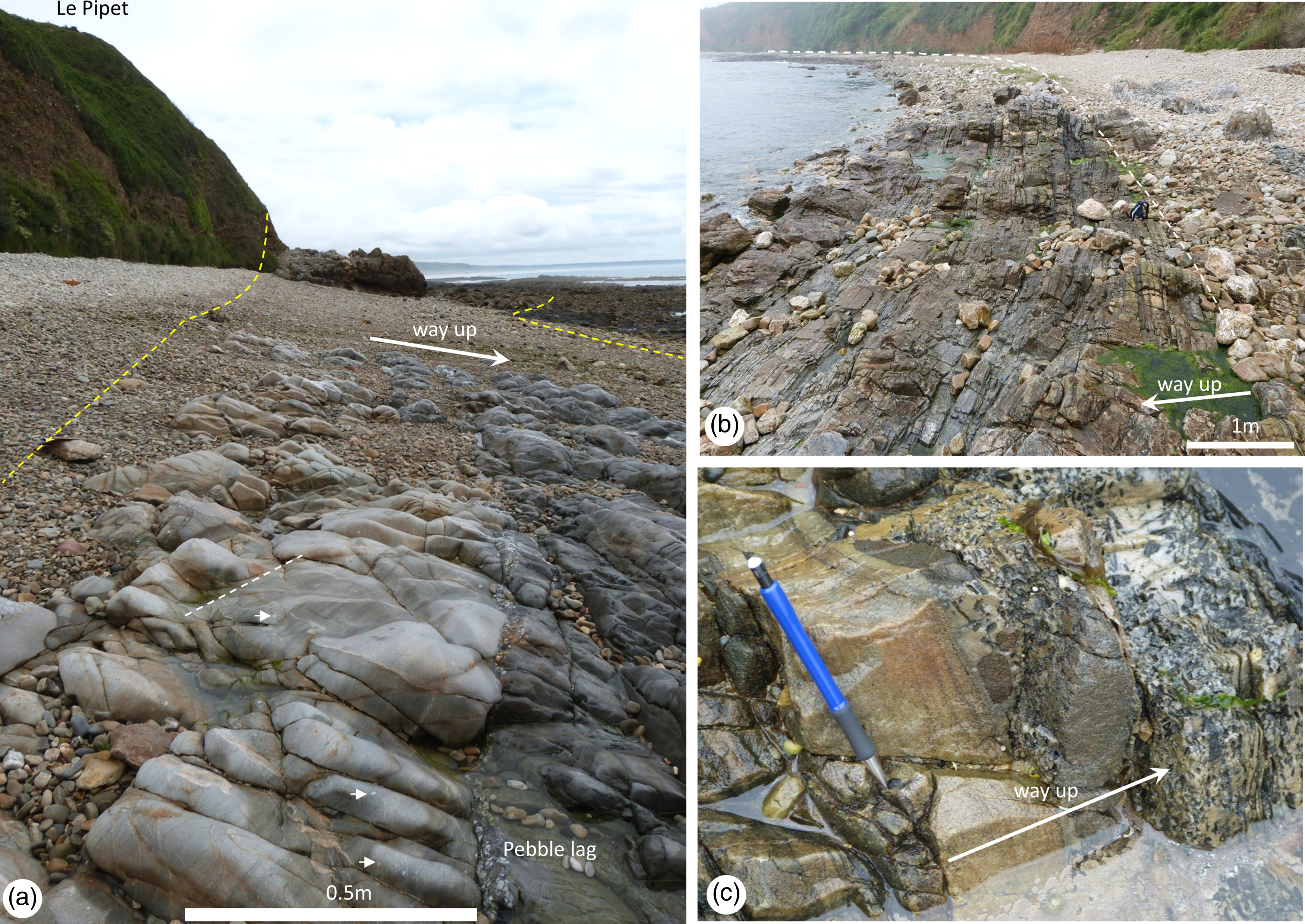
(a) The basal Ordovician strata on the foreshore looking towards the headland at Le Pipet. The light grey, pebbly (arrowed) sandstones show a discordance with overlying dark grey strata, (b) Ordovician sandstones onlapping Cambrian strata at the unconformity (dashed line), foreshore reefs opposite Ruisseau de Herquemoulin, (c) sandstone and pebble conglomerate at the unconformity with the Cambrian, 200 m west of the outfall of the Ruisseau de Herquemoulin. The pebble clasts are composed of sandstone, vein quartz and shale. Pencil is 15 cm long.

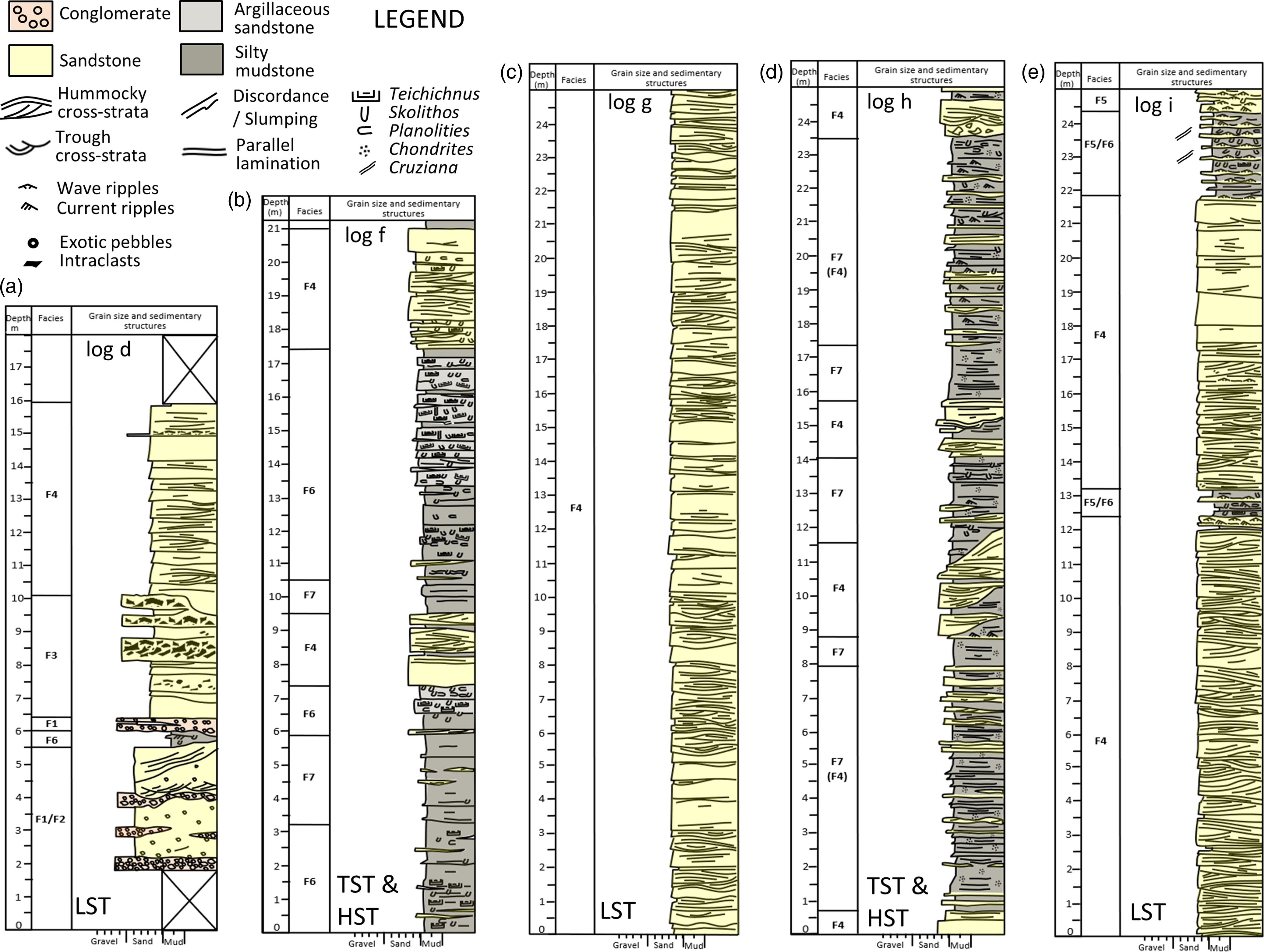
Representative measured sections through the Ordovician strata exposed on the coast south of Herquemoulin: (a) Grès Armoricain Formation, (b) Schistes de Beaumont Formation, (c) Grès de Moitiers d’Allonne Formation, (d) Schistes d’Urville Formation, (e) Grès de May Formation. The relative sea-level conditions prevailing through the deposition of the different formations are noted as follows: LST = lowstand system tract, TST = transgressive systems tract, HST = high stand systems tract.

5.e. Schistes de Beaumont Formation (Darriwilian/Abereiddian)
The Schistes de Beaumont Formation is around 35 m thick and dominated by dark grey, argillaceous sandstone and sandy mudstone which shows abundant bioturbation. Beds of clean sandstone 1 – 3 m thick occur intercalated with the argillaceous strata and account for around 20% of the formation (Figs. 3 and 5b).
5.f. Grès de Moitiers d’Allonne Formation (Darriwilian/Abereiddian)
The Grès de Moitiers d’Allonne Formation is an estimated 150 m thick and dominated by pale-coloured, fine-grained sandstone exhibiting hummocky cross-stratification (Fig. 5c). Mudstone interbeds are very scarce and discontinuous.
5.g. Schistes d’Urville Formation (Darriwilian /Abereiddian)
A significant shaley interval, 60 m thick, is present near Petit Beaumont (Fig. 5d). It is dominated by laminated dark grey mudstone with scarce bioturbation. Beds of clean, buff-coloured sandstone 0.5 to 2 m thick occur intercalated with the laminated mudstone and account for approximately 15% of this formation.
5.h. Grès de May Formation (Darriwilian/Llandeilo)
The Grès de May at this locality is at least 180 m thick. It is dominated by 20–80 cm thick sandstone beds showing hummocky cross-stratification. Thinner beds commonly exhibit wave-formed ripples (Fig. 5e). Thin shale interbeds are relatively common and exhibit trace fossils and body fossils, notably trilobites.
6. Sedimentology of the Ordovician
The Ordovician strata are described in terms of seven facies, summarized in Table 1. The facies are illustrated and demarcated on the representative logs of each formation in Fig. 5.
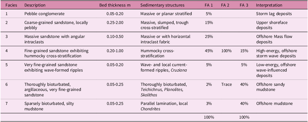
Facies summary. Seven facies and three facies associations (FA) are identified. The facies associations; FA1, Initial transgressive marine; FA2, Proximal, storm-dominated, offshore shelf; FA3, Medial to distal, storm-dominated, offshore shelf, are defined by the abundance of their constituent facies (expressed as a percentage).

6.a. Facies 1. Thin beds of rounded pebble conglomerate – storm lags
6.a.1. Description
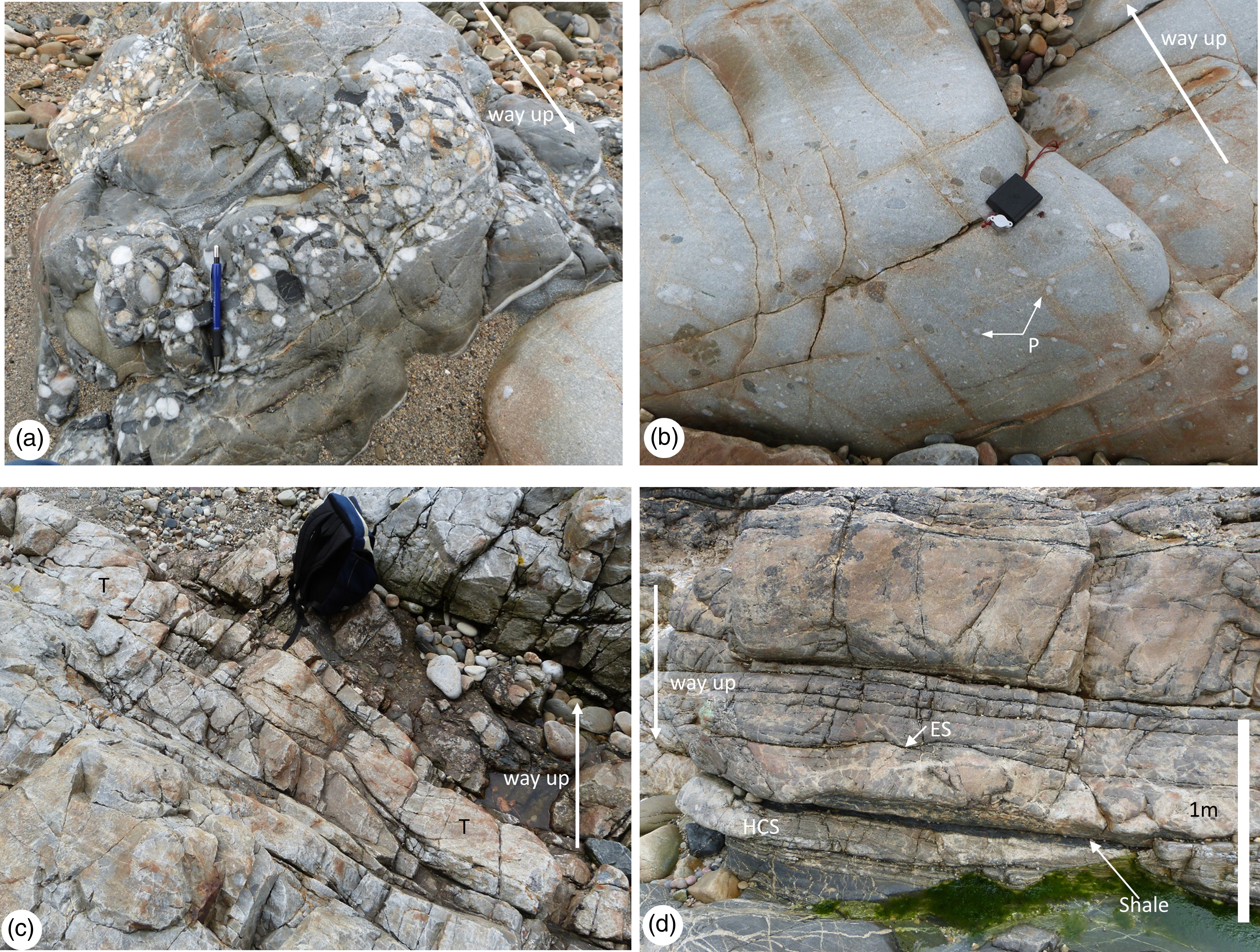
These are erosively based beds, 5 to 20 cm thick of light grey, pebble conglomerate that are common near the unconformity surface in the Grès Armoricain. Beds are typically a few metres to tens of metres in lateral extent. They are dominated by clasts of vein quartz, with subordinate sandstone and granite/porphyry. Clasts are well-rounded and typically 2–5 cm in diameter (Figs. 4a and 6a). They are a conspicuous constituent of the initial stratigraphy of the basin fill in the Grès Armoricain Formation.
(a) Facies 1, pebble conglomerate near the base of the Grès Armoricain Formation, 100 m west of Le Pipet, (b) Facies 2, pebbly (P) coarse-grained sandstone from near the base of the Grès Armoricain Formation, 100 m west of Le Pipet, (c) trough cross-stratified, medium- to coarse-grained sandstone (Facies 2), Le Pipet, daysack is 40 cm high, (d) erosively based beds of fine-grained sandstone showing faint lamination and hummocky cross-stratification (Facies 4), Le Pipet, – note the strata are inverted.

6.a.2. Interpretation
These are interpreted as high-energy traction load deposits. The thin nature of the beds suggests they are pebbly lags to otherwise sandy depositional events. The clasts, which are composed of hard resistant lithologies, are interpreted to have been rounded following exposure to prolonged periods of abrasion in a high-energy environment, such as a beach, prior to their final transport and deposition (cf. Clifton, Reference Clifton1981; Surlyk & Noe-Nygaard, Reference Surlyk, Noe-Nygaard, Miall and Tyler1991).
6.b. Facies 2. Coarse-grained sandstone, locally pebbly – upper shoreface
6.b.1. Description
These are light grey, medium to coarse-grained sandstones which are locally present at the base of the Grès Armoricain Formation. The sandstones commonly contain scattered pebbles or lenses of conglomerate (Fig. 6b). Locally, the sandstones display medium to large-scale trough cross-stratification, with set heights up to 40 cm (Fig. 6c). Elsewhere, they exhibit faint planar to undulose lamination. At Le Pipet, they are locally massive, heavily cemented and veined with quartz. North-west of Le Pipet the sandstone exhibits bedding discordant with overlying strata, suggestive of slumping (Fig. 4a). This facies is only found towards the base of the Grès Armoricain Formation.
6.b.2. Interpretation
These are interpreted as high-energy bedload deposits. The coarse-sand grain size and association with scattered pebbles points to deposition from high-energy flows. The localized presence of trough cross-stratification reflects the migration of sinuous-crested dune bedforms formed in powerful water currents (Guy et al. Reference Guy, Simons and Richardson1966; Harms et al. Reference Harms, Southard, Spearing and Walker1975). Such dunes are common in many non-marine to marine environments, but confirm aqueous, high-energy bedload transport. The faint planar to undulose lamination may reflect washed-out dunes, such as occurs in environments where constructive and destructive forces are both equally active. The properties of the massive, veined sandstones owe their characteristics more to complete diagenetic quartz cementation, making the rock highly competent but susceptible to fracturing during deformation.
6.c. Facies 3. Massive, fine-grained sandstone, typically with abundant angular mudclasts – mass flows
6.c.1. Description
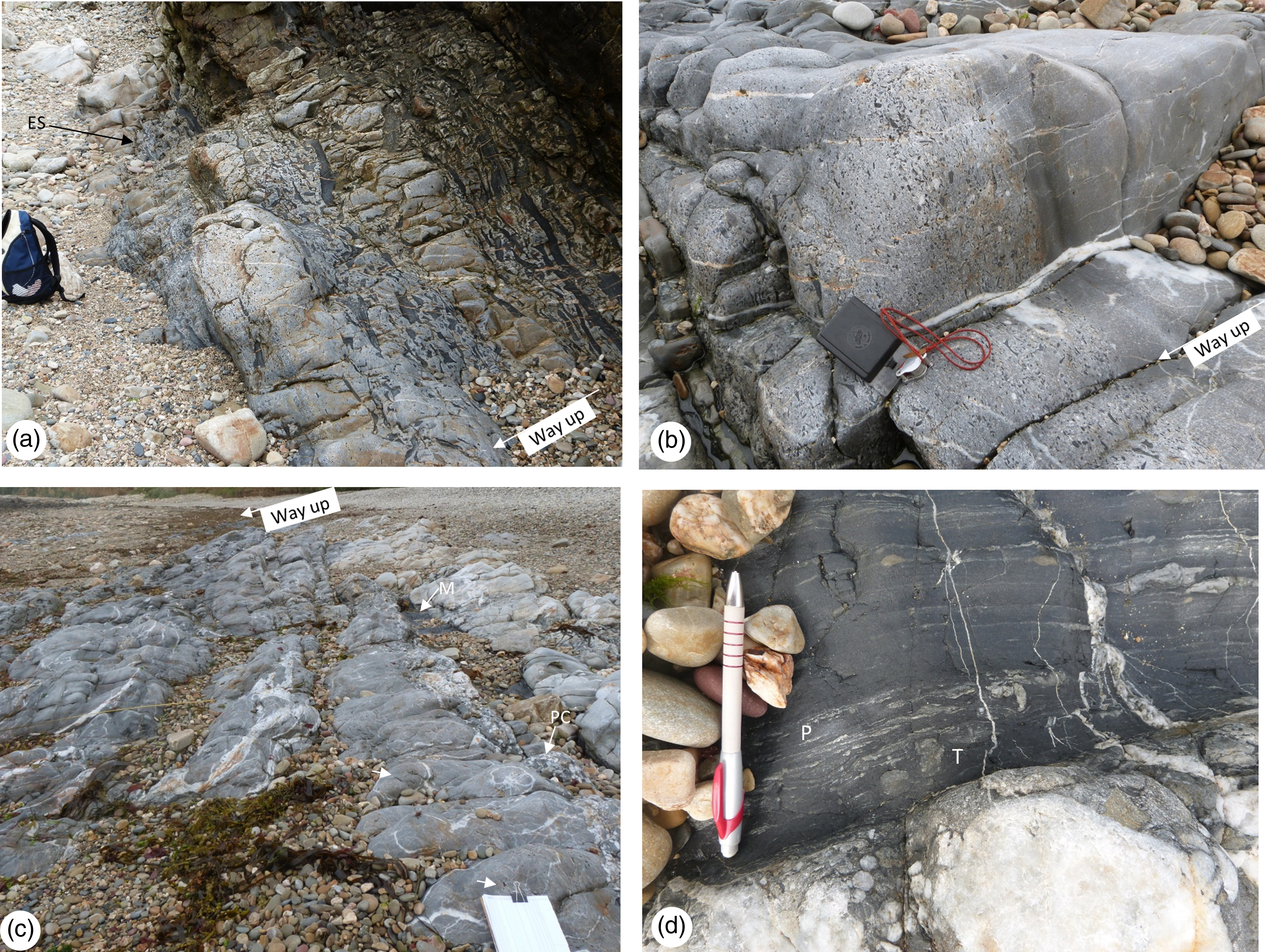
These are light grey, massive beds of sandstone, 10 to 50 cm thick which typically contain a high concentration of abundant angular mudclasts. Mudclasts may be a few mm to cm in diameter (Fig. 7b), but are locally much larger, up to 50 cm in length (Fig. 7a). The mudclasts are tabular, angular fragments of shale with sandy burrowed laminae, akin to mudstones seen in-situ (Fig. 7d). The mudclasts, where present, define a planar fabric, parallel to bedding. This facies is present in the Grès Armoricain Formation.
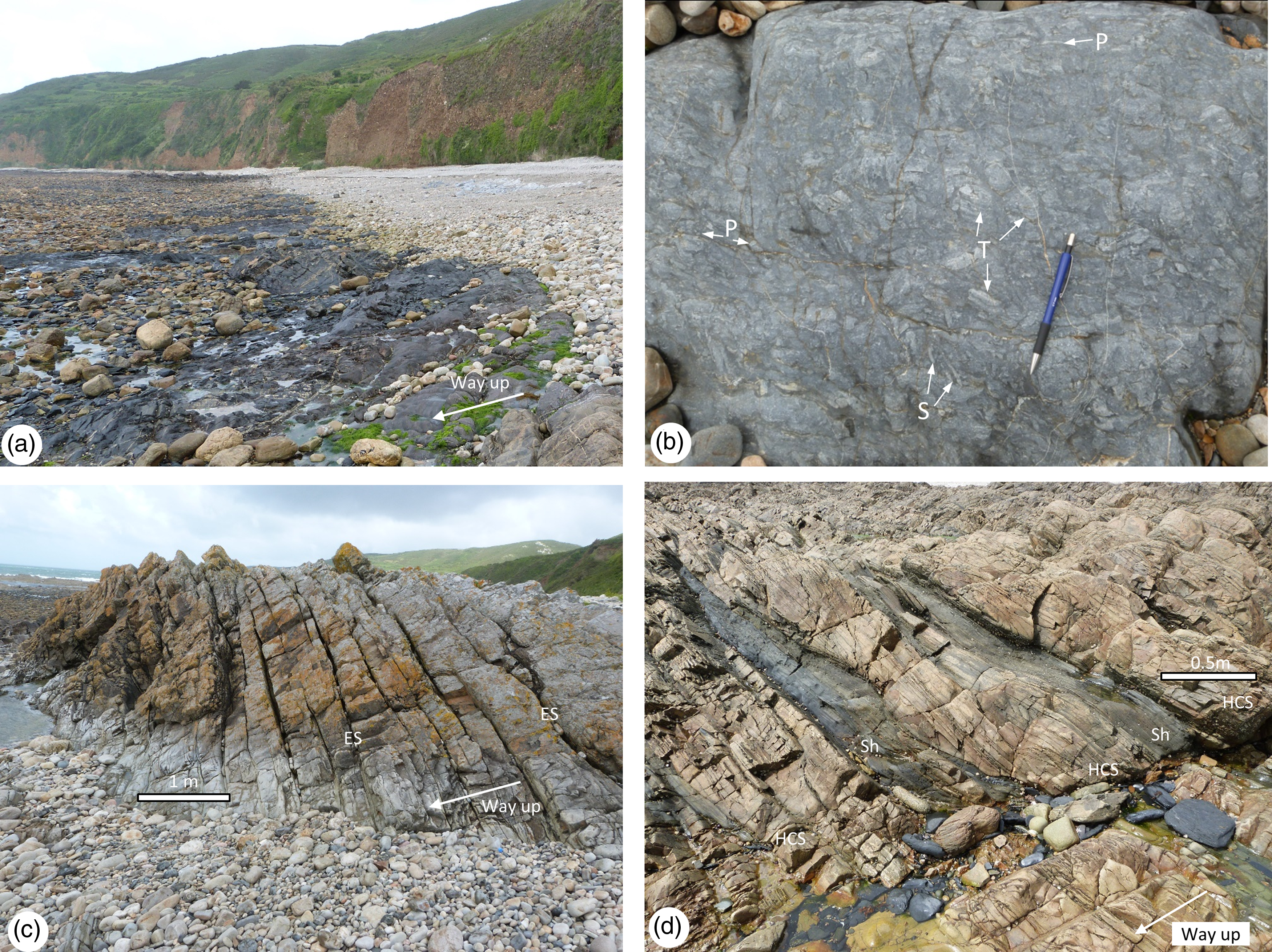
(a) Stacked beds of sandstone containing abundant large mudclasts (Facies 3), Le Pipet. The margin to the upper beds is a steep erosion surface (E/S). Daysack is 40 cm high, (b) Sandstone containing abundant small mudclasts and scattered pebbles of vein quartz (Facies 3). Compass is 10 cm long, (c) Stacked beds of grey sandstone (Facies 3). The sandstones are erosively based, locally show a pebble conglomerate lag (PC) and partly cut out a dark grey mudstone bed (M), clipboard is 20 cm wide, (d) detail from mudstone bed (M) in Fig. 7c (Facies 6), which exhibits thin sandy laminae and trace fossils, including Teichichnus (T) and Planolites/Palaeophycus (P), pencil is 15 cm long: 7b, c and d from foreshore 100 m west of Le Pipet.

6.c.2. Interpretation
These are interpreted as mass flows, deposited in a shallow marine environment (Nelson, Reference Nelson1982; Mutti et al. Reference Mutti, Tinterri, Magalhaes and Basta2007). The beds of sandstone choked with very large angular mudclasts (Fig. 7a) suggest transport and deposition en-masse from laminar flows with limited fluid turbulence (Lowe, Reference Lowe1982). High sediment concentration in transport results in dispersive pressure, enhanced buoyancy, and limited abrasion of clasts. They are interpreted as subaqueous debris flows. Slides, slumps, and debris flows are part of a continuum of mass flows, the most common of which are turbidity currents. The structureless to parallel laminated sandstones, typically with lower concentrations of small mudclasts, suggest deposition from somewhat less concentrated sediment dispersions and are interpreted to have been deposited by high-density turbidity currents (Lowe, Reference Lowe, Doyle and Pilkey1979, Reference Lowe1982; Kneller & Branney, Reference Kneller and Branney1995).
6.d. Facies 4. Fine-grained sandstone, exhibiting hummocky cross-stratification – Storm beds
These are very light grey to buff-coloured, fine-grained sandstones, typically exhibiting hummocky cross-stratification (Figs. 6d, 8c, 8d and 9d). The decimetre- to metre-scale beds are erosively based, exhibit sets of hummocky cross strata 30–60 cm in height and occur repetitively stacked. Locally, they occur associated with co-genetic wave-formed ripples. This facies dominates the Grès de Moitiers d’Allonne and Grès de May Formations. It is also common in the Grès Armoricain Formation and is present in minor quantities in the Schistes de Beaumont and Schistes d’Urville Formations.
(a) Dark grey silty mudstone of the Schistes de Beaumont Formation, near Le Pipet, (b) thoroughly bioturbated, argillaceous very fine sandstone (Facies 6) exhibiting burrows attributed to Teichichnus (T), Planolites (P) and Skolithos (S). Pencil is 15 cm long, Schistes de Beaumont Formation, 150 m west of Le Pipet, (c) stacked, erosively based (E/S) beds (overturned) showing pinch and swell geometries typical of hummocky cross-stratification (Facies 4), Grès de Moitiers d’Allonne Formation, Petit Beaumont, (d) stacked, erosively based (E/S) beds (overturned) of sandstone showing hummocky cross-stratification (Facies 4) with mounded bed tops locally draped with dark grey shale (Sh), Grès de Moitiers d’Allonne Formation, between Le Pipet and Petit Beaumont.

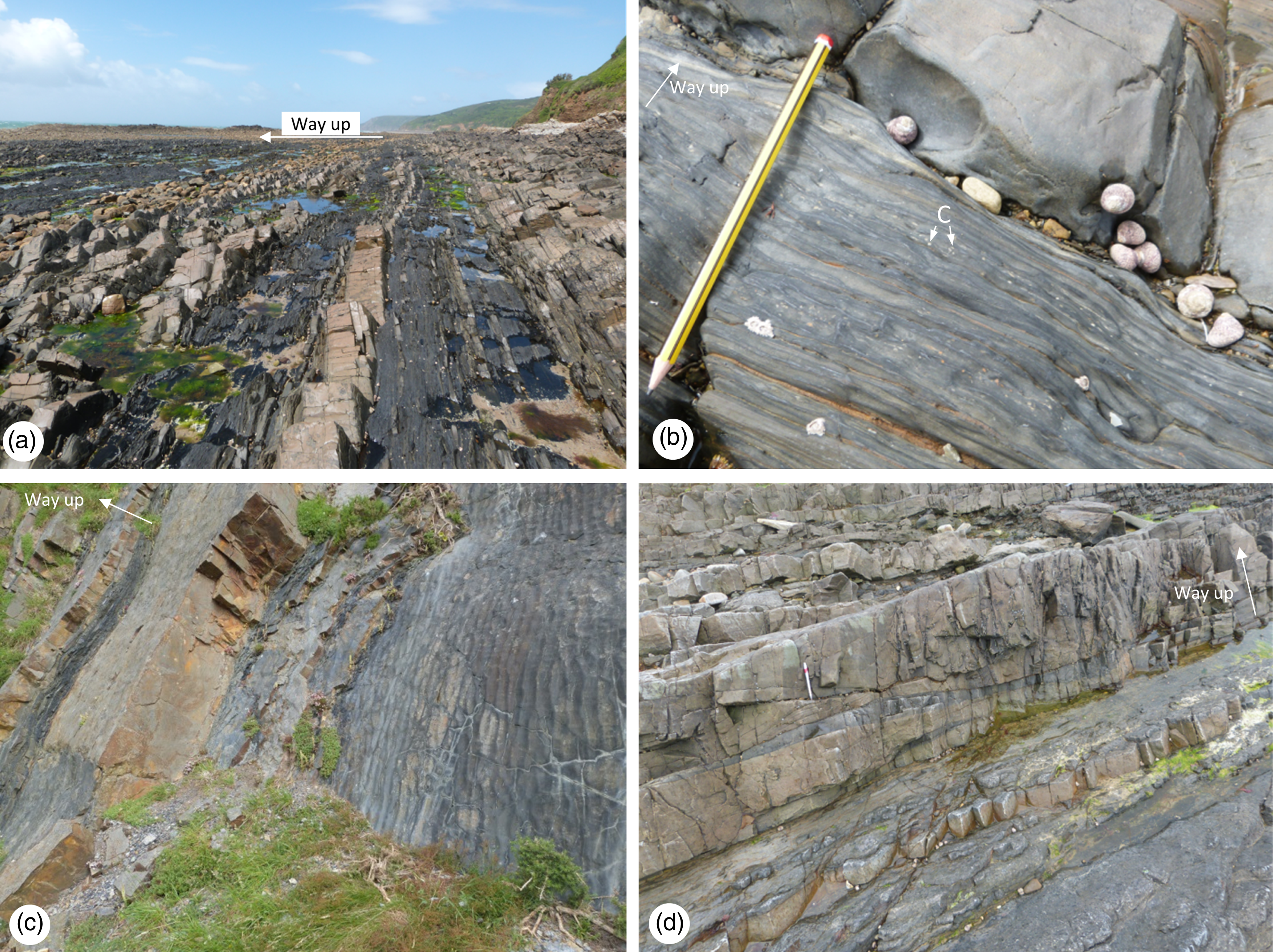
(a) Laterally extensive beds of laminated dark grey shale (Facies 7), intercalated with tabular beds of sandstone, Schistes d’Urville Formation. The beds of sandstone in the right of view are from the top of the Grès de Moitiers d’Allonne Formation; 150 m south of Petit Beaumont, (b) laminated silty mudstone (Facies 7) showing clusters of small burrows, attributed to Chondrites: pencil is 15 cm long, 200 m south of Petit Beaumont, (c) bedding planes showing abundant wave-formed ripples (Facies 5), Grès de May Formation, Vauville quarry, (d) decimetre scale beds of fine-grained sandstone showing hummocky cross-stratification (Facies 4), pencil is 15 cm long, 100 m south of La Palette.

6.d.1. Interpretation
These are interpreted as the deposits of high-energy flows formed under the influence of storm waves. Hummocky cross-stratification is commonly encountered in the ancient deposits of shallow seas. It is generally regarded to form during storms and to be preserved offshore, below fair-weather wave base (Duke, Reference Duke1985; Dumas & Arnott, Reference Dumas and Arnott2006; Yang et al. Reference Yang, Dalrymple and Chun2006). Cogenetic ripples are interpreted to have formed during waning of storm activity.
6.e. Facies 5. Very fine-grained sandstone with wave-formed ripples – proximal offshore shelf
These are thin beds, 5–10 cm thick, of very light grey to buff-coloured, very fine-grained sandstones, typically exhibiting wave-formed ripples, less commonly wavy to planar lamination, and locally current-formed ripples. (Figs. 5d and 9c). Minor drapes of mudstone and/or very small mudclasts are locally associated with the ripple cross-laminated sandstones, particularly near the unconformity in the Grès Armoricain Formation (Fig. 4c). This facies is common in the Grès de May Formation where bedding surfaces locally exhibit bilobed Cruziana trackways. It is also present in minor quantities in the Schistes de Beaumont and Schistes d’Urville Formations.
6.e.1. Interpretation
These are interpreted as deposits formed predominantly under the influence of gentle oscillatory flows (wave action). Parallel planar to wavy lamination and wave-formed ripple cross-lamination are interpreted as related, wave-formed structures formed in moderate- to low-energy conditions, in subtidal, but relatively shallow waters (de Raaf et al. Reference De Raaf, Boersma and Van Gelder1977). Current ripple lamination formed under the influence of low-energy unidirectional currents of indeterminate origin. The Cruziana trackways attest to the movement and grazing of arthropods (Seilacher, Reference Seilacher1985).
6.f. Facies 6. Bioturbated, argillaceous sandstone and silty mudstone – proximal offshore shelf
6.f.1. Description
These are mid- to dark grey, argillaceous, very fine-grained sandstones and silty mudstone that are thoroughly bioturbated (Fig. 8a and 8b). Common identifiable ichnogenera include Teichichnus, Planolites and occasional vertical burrows, akin to Skolithos. Bedding surfaces locally display Cruziana. Bioturbation is typically complete with limited preservation of primary sedimentary structures. This facies is typical of the Schistes de Beaumont Formation and locally present in the Schistes d’Urville and Grès de May formations.
6.f.2. Interpretation
These are interpreted as marine shelf sediments. The seabed was evidently richly colonized with abundant deposit feeders (Teichichnus, Planolites) and less common suspension feeders (Skolithos). The predominance of biogenic over primary sedimentary structures suggests the seabed was below fair-weather wave base. The suite of trace fossils suggests the seabed was well oxygenated with enough water movement, at least periodically, to support suspension- and deposit-feeding organisms (Seilacher, Reference Seilacher1955, Reference Seilacher1967; Pemberton & Frey, Reference Pemberton and Frey1982).
6.g. Facies 7. Sparsely bioturbated silty mudstones – distal offshore shelf
6.g.1. Description
These are dark grey, laminated silty mudstones with little or no clear evidence of bioturbation (Fig. 9a). Primary sedimentary structure is typically simple planar lamination. Bioturbation is typically limited to local clusters of very small burrows which are attributed to Chondrites (Fig. 9b). This facies is typically encountered in the Schistes d’Urville Formation.
6.g.2. Interpretation
These are interpreted as marine mudstones deposited from suspension. The dark grey colour of the mudstones is suggestive of high organic content, whereas the low abundance and diversity of burrows suggests a seabed setting that was challenging for organisms to colonize. It is tentatively suggested the near-surface sediment column was not well oxygenated, an interpretation consistent with the restriction of the burrowing to patchy Chondrites (Bromley & Ekdale, Reference Bromley and Ekdale1984).
6.h. Facies associations, depositional environment and depositional systems tracts
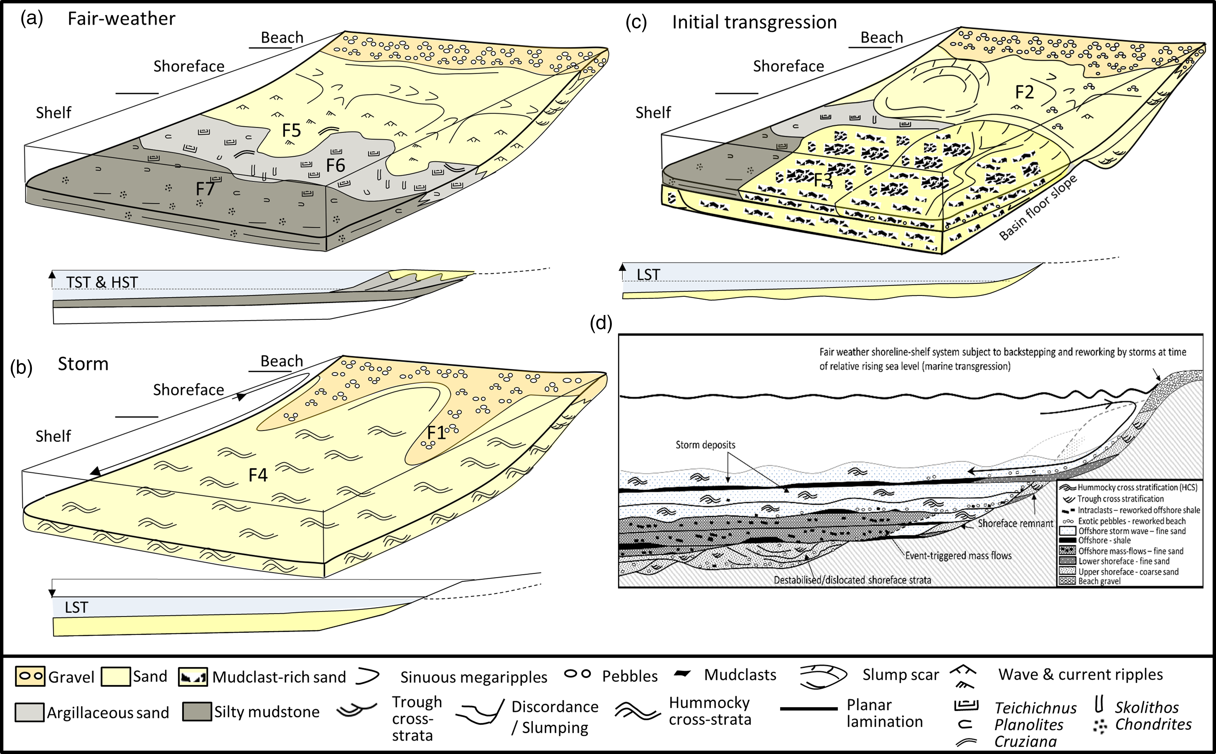
The seven facies are grouped into three facies associations: 1. Initial transgressive marine (Lowstand Systems Tract); 2. Proximal, storm-dominated, offshore shelf (Lowstand Systems Tract); 3. Medial to distal, storm-dominated offshore shelf (Transgressive and Highstand Systems Tracts). A sedimentary model illustrating the interpreted environment of deposition and controls on the development of the sedimentary facies sequences is presented in Fig. 10. In common with most shoreline – shelf systems, distinctive facies associations and stratal successions are developed as a function of depositional environment and relative sea-level changes (Van Wagoner et al. Reference Van Wagoner, Mitchum, Campion and Rahmanian1990; Embry, Reference Embry2002).
Shoreline-shelf depositional setting for Ordovician strata in La Hague and the effects of rising and falling relative sea level. (a) Normal ‘fair-weather’ conditions explain the relative position of sedimentary facies from shoreline to shelf. Rising sea levels typically result in sand being trapped at the shoreline. Hence, mud-prone facies dominate in mid-shelf positions in transgressive and highstand system tracts (TST and HST). These conditions are inferred to have resulted in deposition of the Schistes de Beaumont and Schistes d’Urville Formations. (b) Storm conditions resulted in the offshore transport of fine sand showing hummocky cross-stratification. Falling sea levels result in nearshore environments being bypassed and sand being repeatedly redeposited further out on the shelf in the lowstand systems tract (LST). These conditions are inferred to have resulted in deposition of the Grès de Moitiers d’Allonne and Grès de May formations. (c) The initial Dapingian marine transgression occurred over an irregular land surface and resulted in sediment mantling a seabed that was locally steep and unstable. These conditions resulted in collapse and rotation of strata and the triggering of mass flows in the shallow marine environment. (d) Repeated erosion and backstepping of the shoreline during the initial marine transgression resulted in the deposition of a sheet of sand (the Grès Armoricain Formation) which is a mosaic of shoreface, mass flow and offshore storm deposits.

6.i. Initial transgressive marine association (Facies 1, 2, 3 and 4). Lowstand systems tract
This facies association records the initial marine transgression of a continental shelf (Fig. 10c). It records final cutting of the unconformity and deposition during slowly rising relative sea levels. As such it constitutes the lowstand systems tract part of a depositional sequence (Van Wagoner et al. Reference Van Wagoner, Mitchum, Campion and Rahmanian1990). The surface over which the sea transgressed was irregular, and this influences the characteristics of this facies association and the accompanying lithostratigraphic entity, the Grès Armoricain Formation.
The rounded pebble conglomerates of Facies 1 are interpreted as pebble lags to storm beds and are a minor but conspicuous constituent of the initial stratigraphy of the basin fill. The rounding of the obdurate clasts is ascribed to abrasion on a beach. The beach was subject to storm action and gradual transgression. Storms are envisaged to have reworked the beach with offshore storm surges transporting the pebble material offshore together with sand from the subtidal parts of the shoreface (Kumar & Sanders, Reference Kumar and Sanders1976; Surlyk & Noe-Nygaard, Reference Surlyk, Noe-Nygaard, Miall and Tyler1991). The coarse-grained, pebbly sandstones of Facies 2 are interpreted to represent deposition in upper shoreface environments. The pebbly material is interpreted to have been incorporated from the associated beach, whereas the dunes responsible for the trough cross-stratification are interpreted to have formed from onshore, longshore, and offshore currents which moved sand in systems of nearshore channels and bars, to build and keep the shoreface in equilibrium with the prevailing hydrographic conditions (Komar, Reference Komar1976, Davidson-Arnott & Greenwood, Reference Davidson-Arnott, Greenwood, Davis and Ethington1976; Clifton, Reference Clifton1981). The interval of discordant bedding is interpreted to represent a dislocated section of upper shoreface, possibly one rotated en-masse as a slump scar. Shorelines were established and transgressed resulting in upper shoreface deposits of Facies 2 that are patchily distributed nearby the unconformity. Fortuitous preservation is envisaged to have occurred in niches that avoided reworking, for example, in irregularities in the basin floor (Fig. 10c and 10d).
Mass flows, particularly turbidity currents, are classically described from deep water environments (Bouma, Reference Bouma1962; Lowe, Reference Lowe1982; Mutti & Normark, Reference Mutti and Normark1991). However, they are also known to form in shallow water settings (Nelson, Reference Nelson1982; Mulder et al. Reference Mulder, Syvitiski, Migeon, Faugeres and Savoye2003; Mutti et al. Reference Mutti, Tinterri, Magalhaes and Basta2007). The mass flows in the studied section all occur in the Grès Armoricain Formation. The slopes on the basin floor were transgressed by rising seas. On steeper sections of the basin floor, shoreline and offshore sediments accumulated at an angle, on slopes. As sediment accumulated it is interpreted to have become unstable and prone to failure, yielding shallow water debris flows and high-density turbidity current deposits. Slope failures may have happened naturally or may have been triggered by storms or tsunamis (Mulder & Cochonat, Reference Mulder and Cochonat1996). Once all slopes became flattened and stabilized, these flows ceased. They were succeeded by stacked beds of hummocky cross-stratified sandstone (Facies 4), which record storm wave deposition on the newly healed shelf (Fig. 10b and 10d).
6.j. Proximal, storm-dominated, offshore shelf association (Facies 4) – Lowstand systems tract
This facies association is overwhelmingly dominated by storm wave deposits of Facies 4 and is interpreted to record deposition on the proximal parts of a sandy shelf during relative low stands in sea level (Van Wagoner et al. Reference Van Wagoner, Mitchum, Campion and Rahmanian1990; Embry, Reference Embry2022). Falling sea levels result in nearshore environments being bypassed and sand being repeatedly redeposited further out on the shelf. Slowly rising sea levels allowed for preservation of strata as accommodation space slowly increased. Storms resulted in erosion of the beach and shoreface, and the transport of sand offshore (Fig. 10b). The depositional record in this facies association is dominated by major storm events because accommodation space was limited; fair-weather deposits were repeatedly reworked and thereby scarcely preserved (Fig. 8d). The environmental and basinal processes operating to produce Facies Association 2 resulted in deposition of the Grès de Moitiers d’Allonne and Grès de May Formations.
6.k. Medial to distal, storm-dominated, offshore shelf association (Facies 4, 5, 6 and 7) – Transgressive to highstand systems tract
These are interpreted as the deposits of a storm influenced, medial to distal offshore shelf. The thin sandy beds showing wave-formed ripples and arthropod traces (Cruziana), Facies 5, are interpreted to represent deposition in lower shoreface to proximal offshore shelf conditions, above or near to, fair-weather wave base (Fig. 10a). The thoroughly bioturbated argillaceous sandstones of Facies 6 are interpreted to have been deposited in a densely colonized, slightly more distal, offshore setting. The predominance of Teichichnus burrows suggests a predominance of deposit feeders. The locally developed vertical Skolithos burrows, however, suggest enough water agitation, at least periodically, to support some suspension feeders. A setting close to wave base is indicated (MacEachern et al. Reference MacEachern, Pemberton, Gingras and Bann2007). The more argillaceous, dark grey shales of Facies 7 are interpreted as distal offshore shelf deposits. Unlike Facies 6, the low abundance and diversity of trace fossils in Facies 7 suggest the seabed conditions were less conducive to supporting a prolific marine life. Chondrites burrows are sometimes inferred to reflect lower oxygen levels in the near-surface sediment column (Bromley & Ekdale, Reference Bromley and Ekdale1984). Hummocky cross-stratified sandstones (Facies 4) are intercalated with the above facies and confirm the shelf was still storm-dominated. The depositional record in this facies association is interpreted to be dominated by fair-weather deposits due to accumulation during transgression and high stands in sea level when accommodation space was greater and most coarse sediment was trapped at the shoreline. Storms still affected the shelf but reworked less of the deposited sediments since accommodation space was greater. The environmental and basinal processes operating to produce Facies Association 3 resulted in deposition of the Schistes de Beaumont and Schistes d’Urville Formations.
7. Characterizing the unconformity at the regional scale
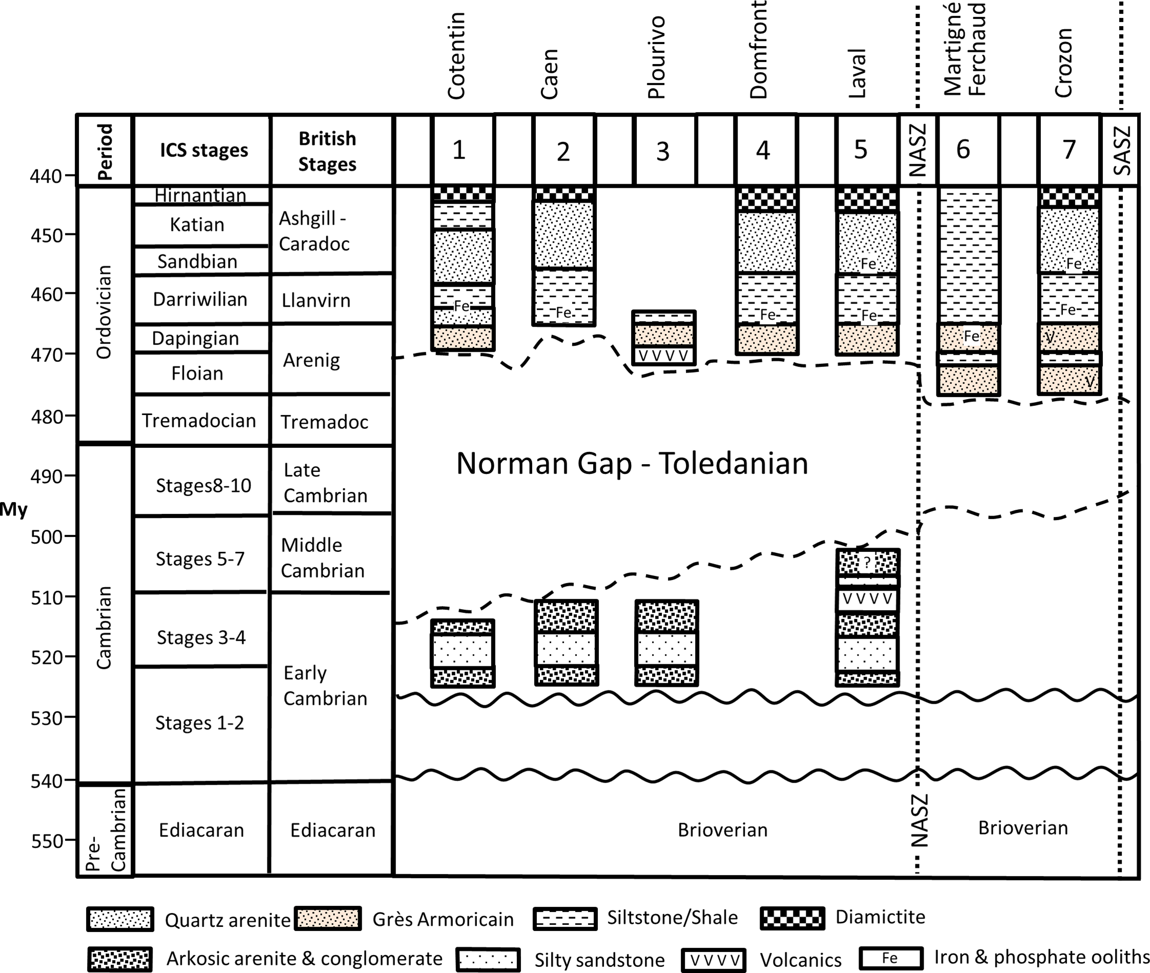
Figure 11 summarizes the age of the Cambrian and Ordovician strata exposed in the north and central sectors of the Armorican Massif. In Normandy, the Cambrian is exclusively of early Cambrian age. In the Pays de la Loire, near Laval, the strata may extend into the middle Cambrian (Doré, Reference Doré, Chantraine, Rolet, Santallier, Piqué and Keppie1994, Went, Reference Went2021). There are no Cambrian strata in the main part of the Central Armorican Massif.
Wheeler diagram indicating the time gap at the unconformity between the Cambrian and Ordovician strata in the North and Central Armorican Massif.

The lowermost Ordovician stratum is typically the Grès Armoricain Formation which is present at all the study locations in the Armorican Massif, except for May-Sur-Orne (near Caen). Chitinozoans indicate the Grès Armoricain is entirely developed in the Eromchitina Brevis zone of late Early Arenig to early Middle Arenig (Floian to Dapingian) age (Paris, Reference Paris1990). By stratigraphic inference, the locally developed initial red beds at Crozon and Martigné-Ferchaud are also assigned to the Early Arenig/Floian (Robardet et al. Reference Robardet, Bonjour, Paris, Morzadec and Racheboeuf1994). The age of the lowermost Grès Armoricain Formation is younger to the north of the North Armorican Shear Zone, where it is entirely middle Arenig (Dapingian) in age. In May-sur-Orne (Caen), where the Grès Armoricain is absent, Darriwilian/Llanvirn age shales of the Schistes d’Urville Formation rest on early Cambrian sandstones.
The regional variations in age of the Cambrian and Ordovician strata at the unconformity indicate a phase of uplift between Cambrian deposition and Ordovician sedimentation. This late Cambrian to Tremadocian uplift was greater in the north of the region where the time gap is some 40 Ma. Further south it is 20 Ma.
The widespread presence of the Grès Armorican, a Gondwana-sourced, super-mature quartzite, above the unconformity supports the notion this is a continental break-up unconformity (Falvey, Reference Falvey1974; Embry & Dixon, Reference Embry and Dixon1990; Alvaro et al. Reference Álvaro, Sánchez-García and Casas2023). It is interpreted to mark the Dapingian/late Arenig as the most likely age of ridge incision (ocean opening) to the north of the Cotentin and implies the synchronous establishment of a passive margin controlled by thermal subsidence rather than rifting.
8. Regional variations in the thickness of Ordovician strata
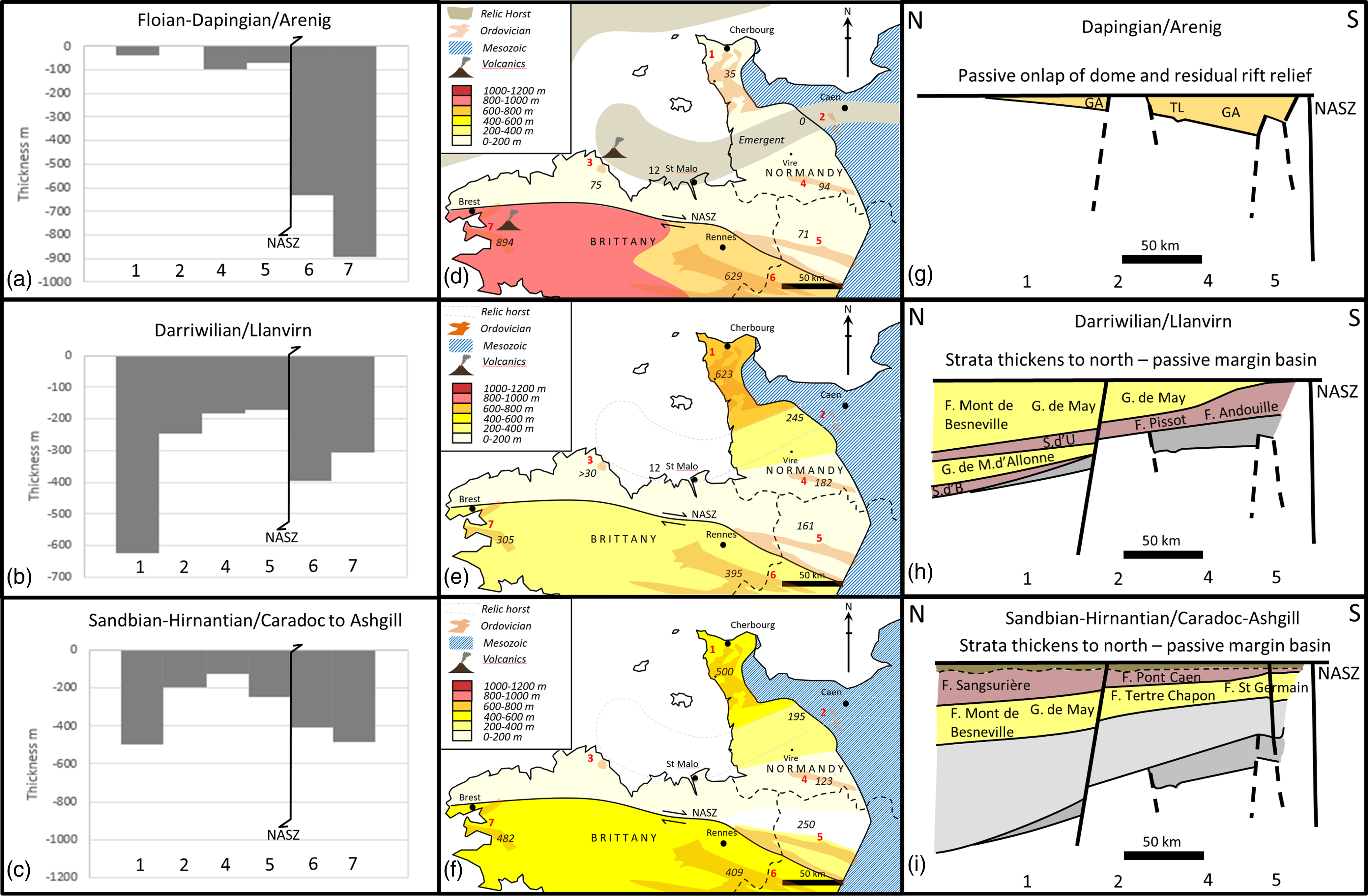
Figure 12 summarizes the variations in thickness of the Ordovician through the region in three time slices, the Floian-Dapingian (Arenig), the Darriwilian (Llanvirn) and the Sandbian-Hirnantian (Caradoc to Ashgill).
Thickness data for Ordovician strata at key locations (marked on the maps) in the North and Central Armorican Massif expressed as bar charts (a–c), maps (d–f) and an interpretation (g–i). Dapingian strata (a, d, g) thin irregularly to the north, suggesting onlap onto residual relief associated with the late Cambrian uplift. The succeeding Darriwilian to Hirnantian strata (b, e, h and c, f, i) conversely display a steady thickening to the north, indicating that from the Darriwilian onwards, the ocean was fully open and firmly established as the main locus of subsidence on the passive margin (h&i). NASZ = North Armorican Shear Zone, GA = Grès Armorican, S d B = Schistes de Beaumont, Sd’U = Schistes d’Urville.

8.a. Floian-Dapingian/Arenig
The earliest Ordovician sedimentary strata in the Armorican Massif are of Floian-Dapingian (Arenig) age. Variations in thickness of this interval largely equates to the thickness of the Grès Armoricain Formation. The regional variations in the thickness of the Grès Armoricain Formation are considerable. It is of greatest thickness in the Central Armorican Massif, at Crozon and at Martigné-Ferchaud (Fig. 12a and 12d). At both localities, initial red beds underlying the Grès Armoricain locally add to the total maximum thickness of Floian-Dapingian/Arenig age strata, yielding 894 m and 629 m at each locality, respectively.
The Grès Armoricain Formation is markedly thinner in the North Armorican Massif, at Laval and Domfront where it is 71 m and 94 m thick, respectively. It thins considerably further to the north around Caen and the Cotentin. At May-sur-Orne, near Caen, it is absent altogether. In the Cotentin it is, on average, 35 m thick; but thinner (15 m) in the north at La Hague, as described above. At Plourivo, the Toul Lan Formation, which is interpreted to be Dapingian/Arenig in age and, at least in part, the lateral equivalent of the Grès Armoricain, shows significant thickness variations within the extent of the outcrop (Egal et al. Reference Egal, Le Goff, Guennoc, LeBret, Thiéblemont, Hallégouët, Houlgatte, Callier and Cairn1995).
In the North Armorican Massif, thickness variations in the Dapingian/Arenig age strata are interpreted to reflect passive onlap onto residual relief, caused by the preceding rifting and crustal upwarping (Fig. 12g). Relief associated with erosional modification of relic fault blocks is postulated to explain local variations in thickness or the absence of the Grès Armoricain, such as at May-sur-Orne. The faults defining previously formed horsts and graben may have moved during the Dapingian but are not considered to have been very active, since subsidence rates were low (0 to 35 m/Ma). Sediment supply was mostly from the Gondwanan continent to the south (Noblet & LeFort, Reference Noblet and LeFort1990). Exposed local highs, however, clearly supplied some coarser-grained material to the lower parts of the Grès Armoricain and Toul Lan Formations at La Hague and Plourivo during the initial transgression.
The dramatic increase in thickness of the Floian-Dapingian/Arenig strata in the Central Armorican Massif suggests a structural juxtaposition across the North Armorican Shear Zone, with right-lateral displacements far exceeding 300 km (the distance between Crozon and Laval). It highlights that the Ordovician of the Central Armorican Massif was probably not deposited anywhere near its present position with respect to the North Armorican Massif. This interpretation finds further support from recent zircon studies which indicate a different source area provenance for Ordovician strata in the North Armorican Massif compared to the Central Armorican Massif (Dabard et al. Reference Dabard, Loi, Pavanetto, Meloni, Hauser, Matteini and Funedda2021). For this reason, no attempt is made to infer anything certain regarding tectono-sedimentary developments across the North Armorican Shear Zone in this or succeeding time slices.
8.b. Darriwilian/Llanvirn
Strata assigned a Darriwilian or Llanvirn age show a pattern of thickness variation that is markedly different to that exhibited by the Floian-Dapingian/Arenig (Fig. 12b and 12e). The greatest thickness of Darriwilian/Llanvirn age strata occurs in the Cotentin (623 m). It is thinner at May–sur-Orne (Caen – 245 m) and continues to thin steadily to the south through Domfront (182 m) and Laval (118 m). The pronounced change to a trend where strata increase in thickness to the north indicates the main depocenter was now to the north. This new depocenter is interpreted to relate to the newly opened ocean. Subsidence rates ranged from 18 to 70 m/Ma, across the North Armorican Massif, broadly comparable to the Dapingian, but faster in the north. The fact there is a fairly abrupt increase in thickness from Caen to the Cotentin suggests the possibility normal faulting may have facilitated differential subsidence on the flank of the ocean (Fig. 12h).
There is a significant two-fold increase in the thickness of the Darriwilian strata south of the North Armorican Shear Zone. As was indicated for the Grès Armoricain, it suggests a structural juxtaposition, and that the Ordovician of the Central Armorican Massif was probably not deposited anywhere close to its present position with respect to the North Armorican Massif, a conclusion in keeping with the differences in the zircon populations of the two domains (Dabard et al. Reference Dabard, Loi, Pavanetto, Meloni, Hauser, Matteini and Funedda2021).
8.c. Sandbian to Hirnantian/Caradoc to Ashgill
The thickness variations seen in the Sandbian to Hirnantian (Caradoc-Ashgill) age strata largely mimic those seen in the Darriwilian/Llanvirn (Fig. 12c and 12f). Subsidence was evidently greatest in the north of the region, decreasing to the south. Subsidence rates ranged from 8 to 34 m/Ma, a slow-down from rates seen in the Darriwilian. The main axis of subsidence evidently continued to be in the north, supporting the interpretation the basin was the newly opened ocean. The marked thickening of the strata in the Cotentin relative to elsewhere suggests normal faulting may have continued to facilitate differential subsidence (Fig. 12i).
8.d. Tectono-sedimentary model
The shift in depositional thickness trends across the North Armorican Massif is interpreted to reflect a change from the passive infill of basin floor relief in the Dapingian, to infill of a growing passive margin depocenter from the Darriwilian onwards (Fig. 12). It is inferred that rifting had ceased and that ridge incision (initial ocean opening) occurred in the early Dapingian, as marked by the age of the break-up unconformity.
9. Discussion
The main purpose of this study was to use field evidence and existing published data to construct a model of stratigraphic development for the Ordovician, relevant to the understanding the crustal evolution of the region.
Understanding the Ordovician starts with understanding the Cambrian. The locally derived Cambrian strata in the North Armorican Massif are rift-fill deposits and may be viewed as evidence of the rift phase preceding ridge incision and drifting. This is not immediately obvious since there is a 20–40 Ma time gap between Cambrian and Ordovician strata. However, it is increasingly recognized that a significant period of crustal uplift is typical of the rift-drift transition in the development of many passive margins (Esedo et al. Reference Esedo, van Wijk, Coblentz and Meyer2012; Soares et al. Reference Soares, Alves and Terrinha2012; Chenin et al. Reference Chenin, Schmalholz, Manatschal and Karner2018). A 20 Ma time gap, the Toledanian, affects the whole of the Gondwana margin from Morocco to Normandy (Alvaro et al. Reference Álvaro, Sánchez-García and Casas2023), but this is more pronounced (40 Ma) at the margin of the North Armorican Massif in the Cotentin. The additional uplift seen in the northern Cotentin is interpreted to reflect either a position more proximal to the axis of a swelling ridge in the English Channel or a more local doming possibly associated with the development of a mantle plume (Casas et al. Reference Casas, Murphy, Díez Montes, Sánchez-García, de Poulpiquet, Álvaro and Guimerà2023).
The Cambrian basins in the North Armorican Massif have been previously interpreted as post-orogenic successor basins formed during a phase of tectonic relaxation after the Cadomian Orogeny (Went & Andrews, Reference Went and Andrews1990; Murphy & Nance, Reference Murphy and Nance1989). This in part stems from the age of the Cambrian strata (527–510 Ma) which indicate a phase of extensional basin development in the early Cambrian that closely followed the end of Cadomian deformation and uplift, currently best dated at 540 Ma (Pasteels & Doré, Reference Pasteels, Doré and Odin1982). The two interpretations are not mutually exclusive. Essentially, the continental margin evolved from one involving subduction and transpression (Cadomian Orogeny) to one characterized by extension and rifting, leading to ridge incision (ocean opening). The Cambrian basins are viewed as both the receptacles for the erosional products of the Cadomian highlands and the product of crustal extension that preceded ridge incision to open the ocean immediately to the north of the Cotentin.
The Ordovician rests on the Cambrian via an unconformity. It is interpreted as a break-up unconformity and to mark the thermal collapse of the north Gondwana margin and the onset of drifting. This is significantly different to interpretations which suggest that a very brief interval at the end Floian-Dapingian (corresponding to the deposition of the initial red beds and Grès Armoricain Formation) was the rift phase (Ballard et al. Reference Ballard, Brun and Durand1986; Bonjour, Reference Bonjour1989; Brun et al. Reference Brun, Ballard and Le Corre1991; Robardet et al. Reference Robardet, Bonjour, Paris, Morzadec and Racheboeuf1994; Plusquellec, Reference Plusquellec, avec la collaboration de Chauvel, Darboux, Gourvennec, Hallégouët, Le Hérissé, Morzadec, Paris and Vidal2010; Dabard & Simon, Reference Dabard and Simon2011; Vidal et al. Reference Vidal, Dabard, Gourvennec, Le Hérissé, Loi, Paris, Plusquellec and Racheboeuf2011, Dabard et al. Reference Dabard, Loi, Pavanetto, Meloni, Hauser, Matteini and Funedda2021). Rifting leads to continental break-up and the development of a break-up unconformity; it does not follow it. Substantial residual relief, on the other hand, is common on break-up unconformities where it results from erosional modification of remnant blocks and basins created from the previous phase of rifting (e.g. Soares et al. Reference Soares, Alves and Terrinha2012). It results in significant variations in thickness in the succeeding post-rift deposits, commonly with some initial red beds passively in-filling the deepest valleys. The variations in thickness and minor conglomerate beds seen in the initial Ordovician deposits of both the north and central sectors of the Armorican Massif are explained by the sediment thinning onto erosionally modified precursor relief, rather than as tectonically active rift-fills. Rising sea levels associated with steady thermal subsidence resulted in the back-fill of valleys, initially with locally sourced conglomerate, sand and mud (initial red beds), and subsequently with mature sand sourced from Gondwana (the Grès Armoricain) (Noblet & LeFort, Reference Noblet and LeFort1990; Dabard et al. Reference Dabard, Loi, Pavanetto, Meloni, Hauser, Matteini and Funedda2021; LeFebrevre et al. Reference LeFebvre, Álvaro, Casas, Ghienne, Herbosch, Loi, Monceret, Verniers, Vidal, Vizcaïno and Servais2023).
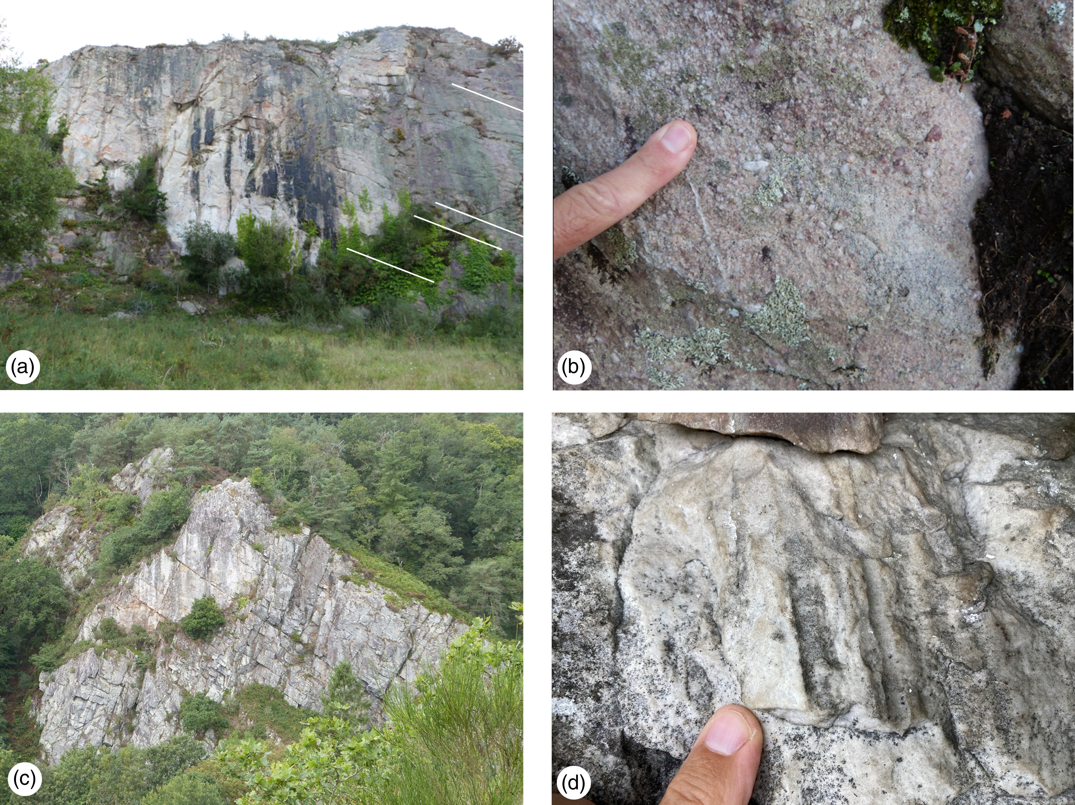
The Toul Lan Formation at Plourivo rests on the Plourivo volcanic formation and shows marked lateral variations in thickness (5–150 m). It contains small pebble conglomerate locally near its base (Fig. 13a and 13b), and Cruziana and Skolithos trace fossils near its top (Egal et al. Reference Egal, Le Goff, Guennoc, LeBret, Thiéblemont, Hallégouët, Houlgatte, Callier and Cairn1995). The thickness, lithology sequence and trace fossil characteristics are similar in many respects to those of the initial red beds transitioning to the Grès Armoricain at Crozon. Exposure limitations make interpretation problematic. However, the thickness and facies characteristics appear consistent with the passive infill of residual relief present at the break-up unconformity surface. The Toul Lan Formation is interpreted to be, at least in part, the lateral equivalent of the Grès Armoricain Formation.
(a) Toul Lan Formation, Plourivo exhibiting repetitively stacked, dcm to m scale beds of massive to faintly laminated sandstone, (b) the Toul Lan Formation sandstones are granular and pebbly towards the base of the formation, (c) The Grès Armoricain Formation at Domfront is composed of repetitively stacked, dcm to m scale beds of massive quartz arenite (quartzite), (d) the beds of quartz arenite in the Grès Armoricain Formation at Domfront are characterized by abundant Skolithos burrows.

The Grès Armoricain at Domfront is conspicuous for the cliffs of quartzite which exhibit abundant Skolithos (Fig. 13c and 13d). Physical sedimentary structures are absent or obscured but a high-energy nearshore marine setting may be inferred from the lithology and Skolithos burrows which point to deposition in agitated marine waters, above wave base. The abundance of Skolithos may be symptomatic of deposition during a time of limited accommodation space as part of the lowstand systems tract. It is interpreted to reflect repeated episodes of sedimentation, then bypass of the nearshore system, the animal burrows recording the repeated colonization of relict nearshore sandbanks.
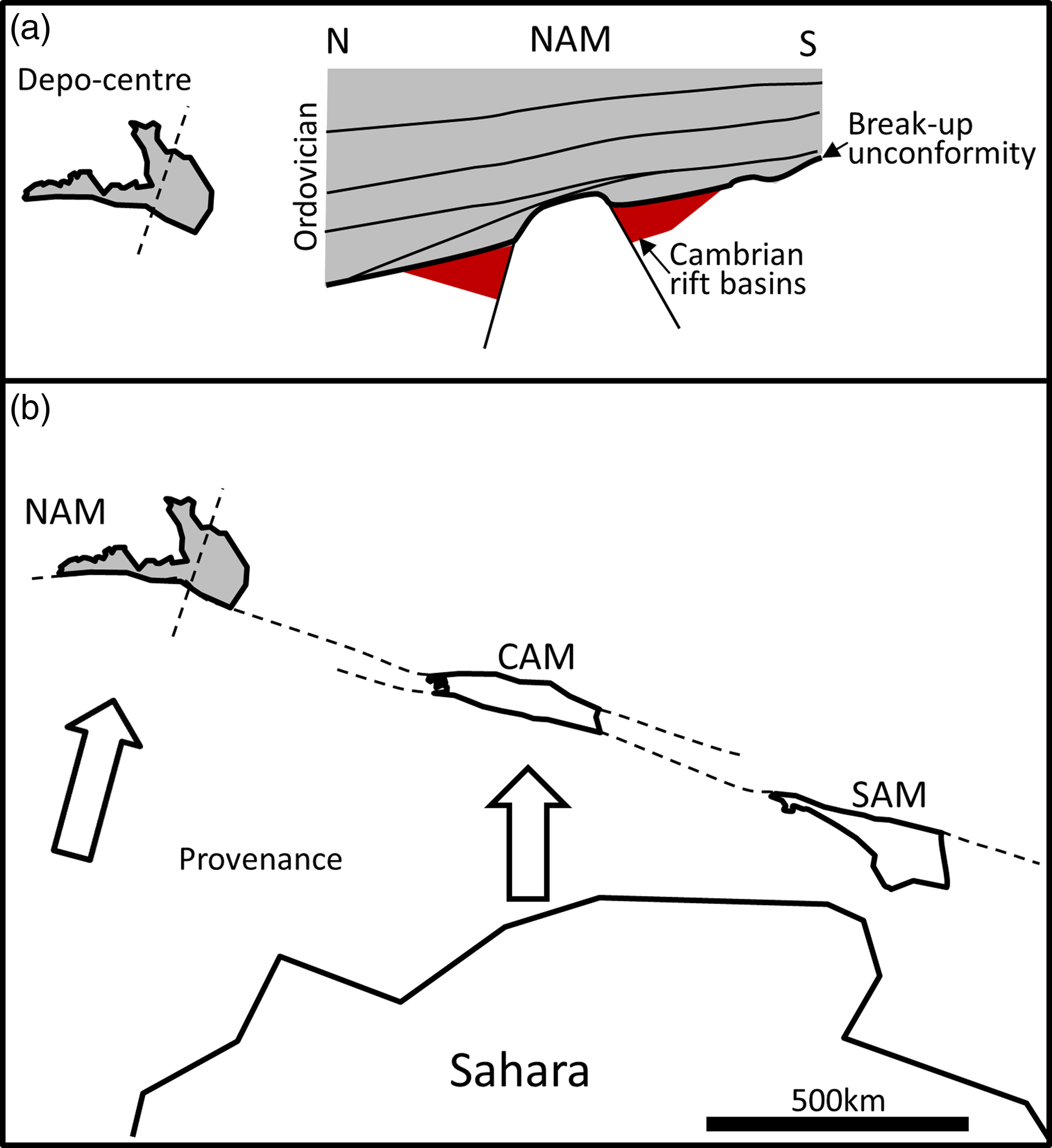
The facies and stratal pattern seen in the Ordovician of the North Armorican Massif appear consistent with post-rift thermal subsidence focussed on a new depocenter located above the old rift zone, that is in the northern Cotentin and to the north of the North Armorican Massif (Fig. 14a). It was in this northerly location, in the developing ocean basin, that subsidence was greatest. Water depth may, likewise, be inferred to increase northwards. This is an interpretation different to that currently in place for the Ordovician of the whole Armorican Massif which suggests water depth increased southwards (Lefebvre et al. Reference LeFebvre, Álvaro, Casas, Ghienne, Herbosch, Loi, Monceret, Verniers, Vidal, Vizcaïno and Servais2023). It is stressed the revised interpretation of northwards deepening is only for the North Armorican Massif which was probably separated from the Central and South Armorican massifs by 100’s to 1000’s km at the time of deposition (Fig. 14b). A significant lateral separation of the South Armorican Massif from the Central Armorican Massif may, furthermore, help explain how the Central Armorican Massif received sediment from the Saharan craton without the obstruction of an intervening rift or embryonic ocean, as suggested by the high-pressure-medium temperature rocks of the South Armorican Massif (Ballèvre et al. Reference Ballèvre, Fourcade, Capdevila, Peucat, Cocherie and Fanning2012).
Model summarizing the stratigraphic development and provenance of Ordovician strata in the North Armorican Massif: (a) Ordovician deposition in the North Armorican Massif followed a phase of Cambrian rifting and exhumation. Stratal patterns suggest a period of passive subsidence focussed on an ocean basin depocenter located immediately to the north of the North Armorican Massif; (b) contrasting zircon signatures in the Ordovician sandstone point to separate source terranes for the North and Central Armorican Massif’s (Dabard et al. Reference Dabard, Loi, Pavanetto, Meloni, Hauser, Matteini and Funedda2021), indicating their wide separation at the time of deposition.

10. Conclusions
Field evidence and regional data have been combined to construct a tectono-stratigraphic model for the Ordovician of the North Armorican Massif.
The Ordovician strata exposed on the coast in La Hague, northern Cotentin, are Dapingian and Darriwilian in age and are represented by five formations: The Grès Armoricain, Schistes de Beaumont, Grès de Moitiers d’Allonne, Schistes d’Urville and Grès de May. Sedimentological facies analysis of these formations indicates deposition in storm-dominated, nearshore to offshore marine shelf environments. Sandy and shaly formations are inferred to reflect deposition in lowstand, and transgressive-highstand systems tracts, respectively.
An unconformity between the Cambrian and mid-Ordovician Grès Armoricain Formation formed from regional upwarping which was greatest in the north of the Armorican Massif. It is identified as a break-up unconformity, and as such, has significant implications for interpretation of the Ordovician stratigraphy in the Armorican Massif. It is inferred to mark the onset of passive margin development, the cessation of rifting and commencement of thermal subsidence.
The Dapingian age Grès Armoricain Formation thins to the north, consistent with passive onlap onto the residual high of upwarped crust. The succeeding Darriwilian strata (Schistes de Beaumont to Grès de May) conversely display a steady thickening to the north, consistent with the main depocenter shifting oceanward from the Darriwilian onwards.
Acknowledgements
The critical reviews of Jiří Žák, Michel Faure, an anonymous referee, and the guiding hand of editor Emese Bordy are each gratefully acknowledged. Their challenging comments helped significantly sharpen the manuscript. This research received no specific grant from any funding agency, commercial or not-for-profit sectors.

 Open access