


The study and preservation of historic water management systems requires the use of legacy data that are stored in older formats, whose intent was never archaeological. These historic systems can highlight how past communities harnessed water resources, but they can also address questions regarding settlement patterns, socioecological resilience, and technological advances (Brewer et al. Reference Brewer, Carr, Dunning, Walker, Hernández, Peuramaki-Brown and Reese-Taylor2017; Kaptijn Reference Kaptijn2018; Lawrence and Davies Reference Lawrence and Davies2012: Šprajc et al. Reference Šprajc, Dunning, Štajdohar, Hernandez Gómez, López, Marsetic and Ball2021). In the western United States, precontact and historic water features such as irrigation ditches, canals, weirs, and wells can be well preserved in archaeological contexts (Boomgarden et al. Reference Boomgarden, Metcalfe and Simons2019; Metcalfe and Larrabee Reference Metcalfe and Larrabee1985; Simms et al. Reference Simms, Rittenour, Kuehn and Cannon2020; Wilde and Newman Reference Wilde and Newman1989). Historic features may be linked to ethnohistoric and archival documentation, whereas others have been mapped and digitized by archaeologists over the past 20 years. These data also are important for understanding historic water management systems within modern settlements. For example, in Utah, historic and precontact canal sites are often utilized for present-day irrigation (Henderson Reference Henderson2012; Simms et al. Reference Simms, Rittenour, Kuehn and Cannon2020). Finally, they can help archaeologists to evaluate their integrity and significance in terms of eligibility for listing in the National Register of Historic Places (NRHP), which is particularly important because rapid development requires government agency and State Historic Preservation Office (SHPO) assessment of effects on eligible historic properties. Whereas past water features can contribute to research on precontact and historic periods, the present and future state of these features highlights how these systems are still, at least in part, essential to living communities.
During research for the Water Heritage Anthropological Project (WHAP), we have encountered several obstacles working with historic water infrastructure, and we have developed several solutions to help mitigate obsolete datasets. In this article, we discuss archaeological geospatial datasets (i.e., datasets that reference a specific geographical area or location) in northern Utah, a part of the Great Basin that is rapidly developing and modifying water features such as canals, which are being piped and modified for more efficient water use at an alarming rate (Walton Reference Walton2021). As part of the multidisciplinary WHAP, we use geospatial data to document historic irrigation systems to provide insight into water heritage (that is, the emotional and physical relationships between water, culture, and community, as described in Hein Reference Hein2020) and to assess impacts under the National Historic Preservation Act. Geospatial datasets, along with archaeological fieldwork and archival research, are essential to the development of a historical context that presents a detailed, longitudinal view of water use in Utah, as well as to reinforce the importance of water heritage to traditional communities. Historic contexts, as well as multiple property and historic district nominations to the NRHP, are crucial to our understanding of the past and create a framework for interpreting and defining the significance of historic and archaeological sites (Hardesty and Little Reference Hardesty and Little2009; Lees and Noble Reference Lees and Noble1990; Morgan Reference Morgan2022). The first step to achieving this goal is the collection of available data and information on water infrastructure from precontact, ethnohistoric, and modern periods. Our experience demonstrates that water feature documentation is often fragmentary, which makes it difficult to evaluate features within a holistic context.
In this article, we first provide an overview of geospatial datasets applicable to historical water management in Utah and highlight some of our project research goals. We then discuss the methods we used for dataset location, collection, storage, and interpretation. We show that many of these datasets are only accessible in gray literature or partially accessible databases online, which makes it difficult to identify and aggregate data in one location. Next, we look at the frequency of piped or open canals in Cache County, northern Utah, and the number of water features that are considered for National Register status as case studies for a broader discussion of integrating water datasets. We conclude by highlighting challenges that arise when working with geospatial datasets, and we recommend four best practices for working with such data to expand documentation of historic water systems. These include (1) locating relevant data and creating a data organization method for working with spatial data, (2) addressing data integrity, (3) integrating datasets in systematic ways across research cohorts, and (4) improving data accessibility. Given the widespread use of geospatial data in archaeology, and the increasing need to aggregate legacy and new datasets, we hope that our experiences will benefit future projects in academic and professional fields that are documenting complex water systems and their associated historic and archaeological features.
DOCUMENTING HISTORIC WATER SYSTEMS
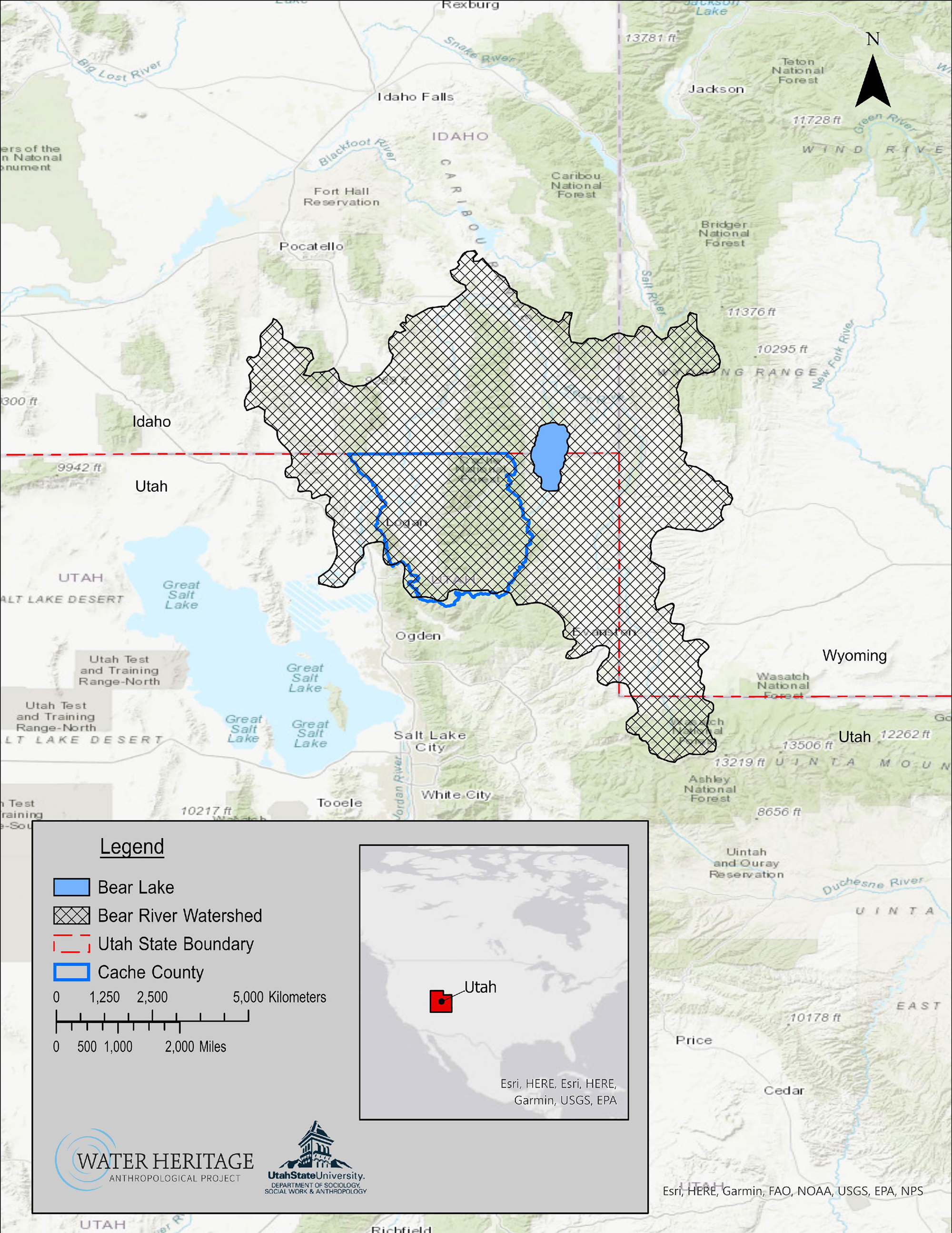
Documenting historic water systems is part of the WHAP project, which investigates the relationship between communities in Utah and precontact and historic water features. Our approach to water heritage incorporates a suite of tools, methods, and theories from archaeology, anthropology, and geography, and it includes geospatial, archival, and ethnographic (interview and oral history) data. By researching and documenting the history of water management and the use of irrigation, water management infrastructure, and agricultural practices, the WHAP applies a long-term approach to studying water in the western United States and aims to inform future water policy. A long-term multidisciplinary approach to studying waterways offers further understanding of past events and leverages our ability to draw insights and possible solutions for contemporary issues such as aridification and drought in the West (Kaptijn Reference Kaptijn2018; Williams et al. 2022). The project also creates materials to educate the public about local water histories and provides mentorship opportunities for students to connect with water heritage studies (Cannon et al. Reference Cannon, Cohen and Jimenez2021). Our current focus is on the Bear River Watershed and adjacent communities in Cache County, northern Utah (see Figure 1), but we are expanding our research to other parts of the state.
The Bear River Watershed is located in northern Utah and extends into the southeastern corner of Idaho and southwestern corner of Wyoming. The watershed is made up of several municipalities, including Cache County, Utah. This area of Utah has been the focus of Water Heritage Anthropological Project (WHAP) geospatial research from 2020 to 2022.
Historic water systems are complex social, environmental, and engineered landscapes, consisting of a series of built environment features facilitating water storage (dams and reservoirs), water extraction (wells), and water conveyance (canals, ditches, aqueducts; Hardesty and Little Reference Hardesty and Little2009:86; Rynne Reference Rynne, Casella, Nevell and Steyne2022; Worster Reference Worster1992). Many of these systems have associated water management components such as levees, hydroelectric generators, headgates, or weirs (McVarish Reference McVarish2008:Chapter 5). These systems manipulate the natural water system across large expanses, and they impact vast watersheds. The nature of cultural resource management projects, limited to evaluations within the Area of Potential Effect, often fail to fully document historic water systems, resulting in fragmented datasets and incomplete documentation. Many of the historic water systems of the West remain in service, complicating documentation of their historic significance further. As water managers strive to meet water demands while experiencing record droughts, modern piping and other engineered improvements to historic systems are often viewed as impacts to the integrity of the historic resource (Walton Reference Walton2021).
The geospatial portion of our research has focused on aggregating Utah water feature data into a geographic information system (GIS) to document historic irrigation systems, including adaptive technology such as canal piping. Using these spatial data, our key questions about water heritage include the following:
(1) What percentage of water features in Utah are considered historically significant, per the NRHP guidelines?
(2) How many historic water features in Utah have been evaluated and documented in their entirety?
(3) Who owns the water rights and controls the usage of historic water systems?
Documenting adaptive technologies that have been employed through time and across Utah shows the evolution of water management in the state and contributes to our understanding of the historical significance of these systems in the region. It also identifies potential water management obstacles for the future. Through our work with water infrastructure geospatial datasets, we have identified several challenges, including the difficulty of locating and aggregating data and making datasets accessible. Consequently, developing a detailed, consistent methodology is critical for addressing such obstacles. As we discuss below, the WHAP has implemented an organizational system to help reduce the loss of data as they change over time and to aid our research team with updating data more efficiently.
INTEGRATING OPEN-SOURCE WATER MANAGEMENT DATA WITH ARCHAEOLOGICAL DATASETS
Historic and contemporary water management data are curated across multiple organizations that range from private canal companies to municipalities and state/federal agencies. Here, we discuss how we integrate publicly available datasets from state agencies to assist in documenting historic irrigation systems. While this is a case study from Utah, state agencies elsewhere maintain similar water management records with various degrees of accessibility.
Much of the data relating to contemporary water infrastructure in Utah are publicly available on websites such as the Utah Geospatial Resource Center (UGRC; Utah Geospatial Resource Center 1991) and the Utah Division of Water Rights (DWRi; Utah Division of Water Rights 2016). The UGRC manages the Utah State Geographic Information Database (SGID) and houses many spatial datasets, including currently documented water infrastructure such as canals, diversion points, reservoirs, and dams in the state. The Utah DWRi is a state government agency within the Department of Natural Resources and manages the distribution and appropriation of Utah's water resources. All waters within Utah are considered public property (Utah Division of Forestry, Fire and State Lands 2022; Utah Code 1953); however, the right to use waterways for farming, irrigation, or culinary practices (i.e., drinking water) requires a legal claim or water right. A water right refers to the permission granted to an individual or entity by the Utah DWRi to divert water from a natural source (i.e., groundwater, natural spring) for use in agriculture, industry, and municipalities. Today, Utah water management companies are privately operated, and they finance the maintenance and construction of new infrastructure with payments from shareholders (farmers, landowners, or other entities that are granted a certain amount of water use by the water-right owner) and government-sponsored grants (Smoak Reference Smoak2020; Utah Code 1953). The Utah DWRi provided the WHAP with important water-rights histories of canals, canal companies, and modifications to water rights dating back to the nineteenth century. Attribute information from the DWRi filled critical gaps for creating a timeline of historic irrigation practices that can demonstrate a feature's historical significance by identifying an association with a time, place, or person that may not be possible via archaeological methods. The Utah Division of Natural Resources also has the Open Water Data server, from which spatial datasets can be downloaded and used to show average precipitation, water levels, and drought records for Utah (for an overview of open datasets on water, see https://dwre-utahdnr.opendata.arcgis.com/pages/more-water-data).
Archaeological records for historic-canal archaeological sites are not publicly available, but some of these spatial data were provided by a request to the Utah State Historic Preservation Office (SHPO). This request stipulated that the project principal investigator(s) first apply for and receive Utah Public Land Policy Coordinating Office (UPLPCO) permits and then request the geospatial data from the SHPO records. Archaeological site forms and survey reports for historic canals in Utah came from the Department of Cultural Community and Engagement digital database and, like the request for spatial data, required a permit from the UPLPCO for access. The archaeological site forms and survey reports document field observations for evaluating historic water systems and irrigation features. A key aspect of the project is to compile information on the NRHP eligibility statuses of water features in order to determine where future documentation and evaluations are needed and to ultimately advise the SHPO on how to proceed with NRHP nominations.
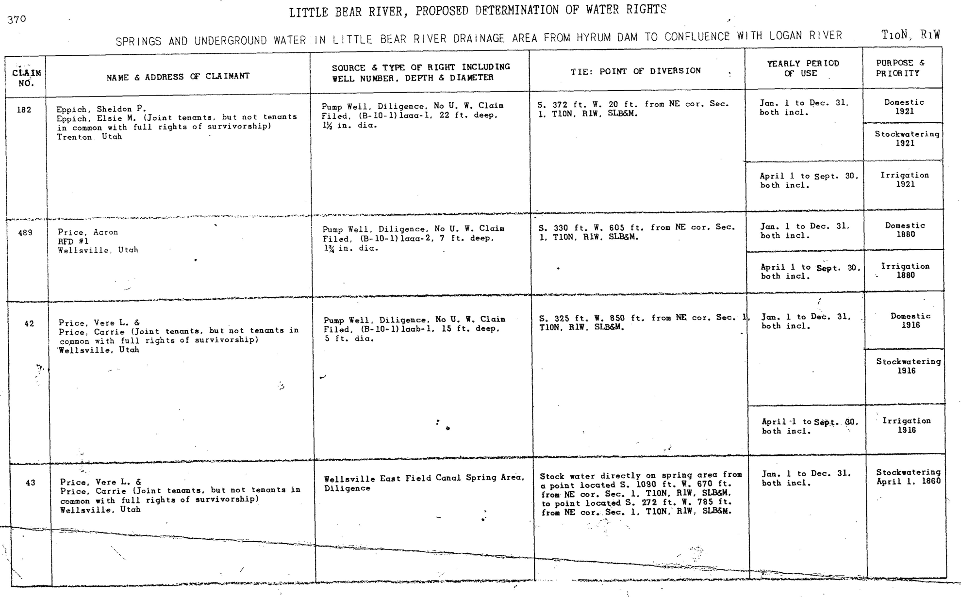
Our geospatial efforts integrate the canal geospatial dataset from the UGRC, historic water rights attribute information from the Utah DWRi, and archaeological information from the Utah SHPO (see Table 1 for a list of databases and accessibility). For example, the Wellsville Canal, located in southern Cache Valley, was originally constructed in 1850 as a 8 km (5-mile) long gravity-fed irrigation canal that diverted water from the Little Bear River (Figures 2 and 3). Information from the Utah DWRi provides the history of management of this system, including determination of water rights, how water was diverted, and for what purposes (Figure 3). Archaeological and historic record information, such as codes used to identify feature attributes (e.g., in service), were also included, as well as any information about the date of construction. Using these datasets, we also created a master geodatabase and smaller databases for addressing research questions about historic water systems in Utah. For example, we are interested in how water systems differ across Utah; consequently, we used the historic canal datasets from the Utah SHPO and the history of water rights from the DWRi to generate comparative analyses between counties with high-density historic water infrastructure investments, such as Cache County (or the Bear River watershed), versus those with sparse investments, such as San Juan County (the southeast Colorado watershed) in southern Utah. This smaller database quickly enables us to visualize the vast differences between the two regions and to collect additional information that addresses the variation, including land ownership and demographic data.
Map of canals in Cache County classified as either eligible, ineligible, or unevaluated for listing on the National Register of Historic Places (NRHP). The majority of canals in the county have been unevaluated, but the canals that have been evaluated are eligible for a NRHP listing. Old Newton Dam, symbolized by a yellow polyline, is the only listed historic site on the NRHP.

List of claims and proposed water rights determinations from the Wellsville canal in the nineteenth and early twentieth centuries. Information from the Utah Division of Water Rights.
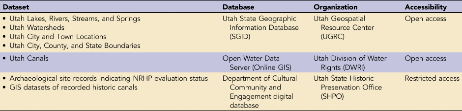
Databases Used in WHAP Research and Accessibility.
Another important component of the WHAP is to prioritize data management within research, teaching, and collaborative contexts (see discussions in Cohen et al. Reference Cohen, Klassen and Evans2020; Garstki Reference Garstki2022; Kansa and Kansa Reference Kansa and Kansa2021; Smith Reference Smith2021). Like other large research projects, the WHAP employs a rotating group of student researchers and collaborators, which necessitates a data management plan that ensures consistency in data generation across research cohorts. Metadata (i.e., a set of data that provides and describes information about other data; Comber et al. Reference Comber, Fisher and Wadsworth2008) are maintained within a common separated value (CSV) file and then embedded into geospatial data files (also called “shapefiles”). This CSV file contains relevant information: a list of spatial datasets gathered, where we obtained the data, who has manipulated or contributed to the attributes of a dataset, why those data were manipulated, how or what was added to those data, disregarded data irrelevant to our project, as well as where and how those data were used during the project (e.g., maps, ESRI StoryMaps, conferences; Table 2 summarizes the metadata codex). This data organization technique—though time consuming—creates a seamless flow of information that can pass through multiple collaborators throughout the project with as little data loss as possible while documenting the life history of the dataset. A data organization document with a chart and visual instructions for how to organize spatial data was created to instruct new project members moving forward. This document is housed in a collaborative online cloud folder (Box) within the WHAP file geodatabase (ArcGIS Online) and ultimately curated within the USU Digital Commons (https://digitalcommons.usu.edu/water_heritage/). Although the project currently focuses on Cache County in northern Utah, as we add spatial data from other regions of Utah, we will continue to update and maintain our data files for future use.
WHAP Metadata Master File Codex.
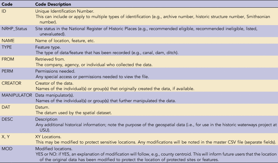
Note: This codex was used to organize data created or obtained from outside sources with the WHAP geodatabase. Maintaining this information allows for quick knowledge transfer between multiple collaborators, and it prevents the loss of vital information about the origin of data and the manipulation of datasets.
Historic Canals in Cache County
The history of Utah's water management is complex, with periods of communal management and complicated private-government initiatives (Smoak Reference Smoak2020; Toelken Reference Toelken1991). Early Latter-Day Saints (colloquially, Mormon) settlers viewed water as a communal resource: individual rights were secondary to community needs, with water rights controlled under the direct administration of the Mormon Church (Alexander Reference Alexander2022; Arrington and May Reference Arrington and May1975; Harvey Reference Harvey1989; Houston Reference Houston2002; Thomas Reference Thomas1920). During the last quarter of the nineteenth century, water development projects occurred mainly as private ventures commodifying water. Water development in the twentieth century evolved into a joint venture between local, state, and federal government agencies (Smoak Reference Smoak2020). Cache County embodies this history through its archaeological and historic water infrastructure, and today there are a few large companies that manage water in the county (e.g., Bear River Canal Company and Cache Highline Water Association) and many small, locally, and family run water management facilities (approximately 50 entities in the county; Cache Water District 2015).
Gathering information on the eligibility status of historic water features helps determine if additional fieldwork or research is needed to document more water features in Cache County, as well as direct preservation practices such as creating a statewide historic context or a multiple property NRHP nomination. According to our growing database in Cache County, approximately 31% of canals (see Figure 2) have been evaluated and recommended as eligible, many of which are canal segments and not the full length of the feature. This is likely because a canal was evaluated within a particular cultural resource management project's Area of Potential Effect rather than in the canal's entirety. As of 2021, only one water feature, Old Newton Dam (see Figure 3), is listed on the NRHP. Most canals in Cache County are unevaluated (~63%), but from the sample of evaluated canals, very few have been recommended as ineligible (~6%). Further assessment of an entire canal and other water features, especially for canals assessed in fragments, will aid in the documentation and preservation of historic knowledge that these features offer to researchers and the public.
Piping is a common upgrade to in-service historic canals in the Mountain West because it conserves water by reducing seepage into the arid soils and reduces overall maintenance costs in the long term (Edwards et. al. Reference Edwards, Bosworth, Adams, Baji, Burrows, Gerdes and Jones2017; Shupe Reference Shupe1982). Despite the benefits of piping, their construction can negatively impact water heritage for community members by removing access to open water features for recreational or personal use. In addition, some conservationists argue that piping is expensive and focuses too much on large canals rather than on smaller ditches, which are commonly used by small farmers and communities (World Health Organization 1988). Documentation of piped versus open canals is therefore an important step for identifying when and at what rate canal modification is occurring because it allows researchers to determine the long-term benefits of piping and areas where piping is needed most.
Our work considers the impact that piping and other canal improvements have for the historic integrity of in-service historic canals. Of the 335 documented canals in Cache County within our spatial database, approximately 18% are labeled as piped as of 2013 (Figure 3). Some of the documented open canals have been piped over the past few years. Our goal is to update files with the current standing of canal features, along with their evaluation status for listing in the NRHP. Compiling this information will aid archaeologists in determining which historic canals need evaluation, documentation, and revisitation. It is important to document historic features, both in use and abandoned, to ensure a detailed and organized framework for historic context (Hardesty and Little Reference Hardesty and Little2009; Morgan Reference Morgan2022). Furthermore, as water becomes increasingly scarce in Utah, there is a need to prioritize water conservation, which could be in the form of piping or other infrastructure changes to canal systems (Anderson Reference Anderson2013; Armstrong and Jackson-Smith Reference Armstrong and Jackson-Smith2017; Edwards et. al. Reference Edwards, Bosworth, Adams, Baji, Burrows, Gerdes and Jones2017; Walton Reference Walton2021). Given that much of the canal infrastructure has both historic architectural and cultural significance to state heritage, archaeologists must prioritize the documentation of the infrastructure before it is modified or destroyed.
INTEGRATING WATER MANAGEMENT AND ARCHAEOLOGICAL DATA FOR HISTORIC WATER SYSTEMS: CHALLENGES AND SOLUTIONS
Creating a historic context for canal infrastructure in Utah requires data from various sources—such as the Utah SHPO, the UGRC, and the Utah Division of Natural Resources—to create a comprehensive picture of water infrastructure changes in Cache County. Integrating datasets from multiple sources into a GIS can be complicated because individual datasets often have unique sets of codes and identifiers for attributes with limited or no associated metadata. As discussed above, water management datasets may not contain the most current information regarding water infrastructure, such as recent piping and dam expansions. Below, we highlight some of challenges and proposed solutions when integrating water management datasets with archaeological data, including how to locate appropriate data with integrity, how to integrate the data, and how to make them accessible.
Locating Relevant Water Management Data
There are a limited number of publicly available datasets that contain recently updated information about canals and water rights. However, finding such data can be a laborious process. One initial step might include requesting information from the individuals or agencies that originally collected the spatial data regarding the codes, attributes, or other coding decisions they made when creating the data. This may be an essential step because these data were invariably collected in different ways, resulting in a lack of standardization and frequent use of discipline-specific jargon, acronyms, and coded information and making analysis difficult without first translating the data into usable language for archaeologists. During the initial stages of the WHAP, this supplemental research involved contacting the entities that collected the data and requesting a codex, guide, or other document describing the data. Sometimes this was feasible, such as with SHPO-restricted data; but in other cases, contacting large organizations with open data servers, such as the Utah SGID, was an exercise in futility. The COVID-19 pandemic also exacerbated our difficulties with communication because canal companies and federal and state agencies were difficult to reach.
One of our solutions was to locate similar research and to try to define codes within the context of like datasets. For example, we located informational web pages from the Utah Division of Water Resources (Utah Division of Water Rights 2018) that explained some of the codes, such as “MaxCFS,” a common code used in water research to quantify a canal's flow capacity, maximum cubic feet per second. Deciphering acronyms and jargon are not new issues, and spatial datasets with undocumented codices or data dictionaries are common in open data sources (Barry and Bannister Reference Barry and Bannister2014; Comber et al. Reference Comber, Fisher and Wadsworth2008). The expansive nature of water studies exacerbates this issue, where there are a variety of publishers from different disciplines contributing to these servers, each with different geospatial goals, disciplinary language, and access provided to datasets. Solutions and topical focus in water-related geospatial datasets are inconsistent and tend to shift from the provision of metadata to the ease of access and manipulation (Corsar and Edwards Reference Corsar and Edwards2017).
Addressing Data Integrity
Another major challenge is that available public datasets are often obsolete. In the case of Cache County (as of Summer 2020), most spatial information on canal status is from 2013, and since that time, there have been numerous canal piping projects in the region (e.g., Schill Reference Schill2021; Webb Reference Webb2021). This means that we had to update the obsolete data ourselves, and that required additional time to call canal companies or visit some of the canal segments. The lack of public access to the current status of water features creates challenges for researchers establishing historic contexts or submitting NRHP nominations who do not work for the data managing entity. Additionally, much of the data available on open data servers are raw or in an original data collection format, meaning that they are neither fully processed nor organized. Data access may be quicker, but it is not as informative (Wang et. al. Reference Wang, Fang, Liu and Horn2018).
One way that we addressed data integrity is by combining incomplete or obsolete data with compatible supplemental data that were gathered by archaeological or historic preservation projects. The WHAP has been conducting reviews of past NRHP evaluations and surveys of canal infrastructure in northern Utah and incorporating information from those evaluations into our master historic canal dataset, which shows the current canal infrastructure. These data include the eligibility status of historic water features and modifications to canals after 2013 (i.e., piping or lining). Updating the current status of a historic feature is important for determining documentation priority for undocumented historic features that are marked for upcoming modifications or upgrades.
Integrating Data
Datasets collected from multiple sources required manipulation and updates. For example, we gathered public data containing information on water infrastructure, but these data often do not contain information about historic status or current standing. Another challenge is that the spatial data utilized for this project are repetitive and require manipulation, including closing polygons and smoothing or appending linear features. Within the Utah canals dataset, we discovered that many canals were documented in segments. Some of these segments are named using codes (segment A, segment B, etc.) that may represent different historic periods of construction or use, whereas others were assigned with the name of the canal. This becomes an issue when creating a more detailed visual representation of the canals (i.e., with individual canals labeled on maps for presentations or other outreach products), where preservation of some but not all of the coded attribute information is necessary and requires more work designing, rewriting, and reimagining legends and labels—and sometimes recreating the feature datasets to be continuous polylines (see Figures 4 and 5 for examples).
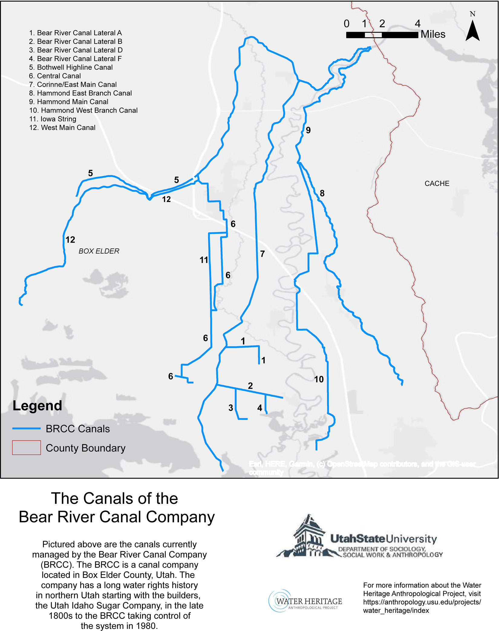
Map showing historic and modern (piped) canals within the jurisdiction of the Bear River Canal Company in Box Elder County, Utah. Many GIS users struggle with displaying labels for large data files within a small spatial context, such as this canal infrastructure. To solve this issue, numbers were used to label canals within the maps.
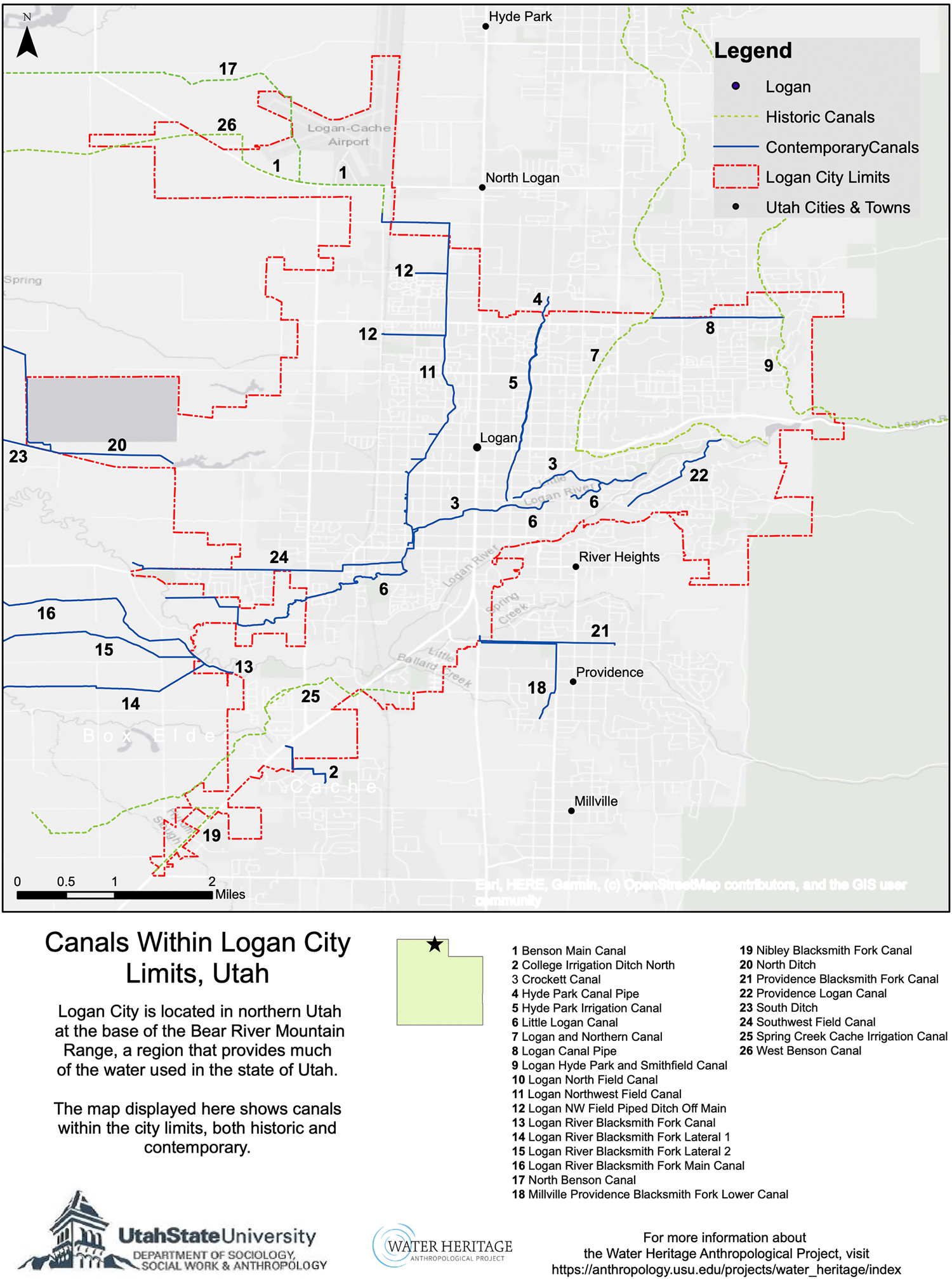
Map showing canal infrastructure in Logan City, Cache County, Utah. The canals are classified as either historic or contemporary based on State Historic Preservation Office (SHPO) guidelines—that is, if a canal was built within the last 50 years, it is considered contemporary. This map is an example of how Adobe Illustrator was used as a supplemental application to create a comprehensible legend and canal labeling scheme.
Retaining and creating metadata and a geodatabase are critical for preserving historic contextual information from legacy datasets and for documenting geospatial and attribute manipulations (Comber et al. Reference Comber, Fisher and Wadsworth2008). In addition to basic metadata fields regarding the source, age, and ownership of data, the metadata catalog should detail who has worked with or manipulated a dataset, and how that data may have changed over time. This is especially useful within long-term projects that work with multiple undergraduate and graduate students throughout the duration of the research. Given that students and other project collaborators may change regularly, the metadata catalog provides both a manual for future additions and a record of past modifications. Storing the metadata within the geodatabase will ensure that spatial data is organized, secure, and easily accessed by multiple users. The metadata also includes deciphered codes from original datasets and their meanings, as well as the codes created by the WHAP for supplemental data added from our ongoing research. Finally, we recommend working with a file geodatabase that stores and queries spatial data because the structure allows for a smooth transfer, upload, and dissemination of spatial data through multiple sources. A geodatabase will benefit not only data organization but also functionality and shareability; the size of a file geodatabase is limited only to the hard drive's available disk space and can be compressed for easy transfer between users.
Making Data Available and Accessible
A final challenge relates to how to make water heritage datasets more accessible to other researchers and the public. Visualizing cultural heritage via accessible, printed maps is an important part because it allows us to illustrate a connection between artifacts, other material remains, and the landscape (Warner-Smith Reference Warner-Smith2020). Although spatial data can be collected, stored, processed, and displayed using GIS platforms such as ESRI products, QGIS, or GRASS (Hacigüzeller Reference Hacigüzeller2017), more thoughtfully drafted accessible maps are an important tool for engaging communities and for providing a straightforward presentation for the public. The vast number of canals in northern Utah alone makes it difficult to create comprehensive maps for the state, so we have produced only general regional maps thus far. Labeling and classifying large amounts of spatial data within one map presents several visibility issues. Labeling too many canals within the GIS at an inappropriate scale means that more spatially extensive canals are labeled, whereas smaller, less extensive canals are not automatically labeled. Fragmented data creates a related set of concerns, causing excessive labeling that is difficult to mitigate without the time-consuming task of creating new feature datasets. An automated legend is also problematic because there are too many segments to create a comprehensible inscription.
Mapping the Cache County canal systems presents examples of these challenges. Our efforts to visualize a comprehensive map of all Cache County canals encountered aesthetic drawbacks, including overcrowding and low resolution. We remedied this by producing a series of regional maps of Cache Valley and surrounding areas focusing on fewer canals at a time, as well as using additional graphic design software—such as Adobe Illustrator—to create legends and labels outside of the ArcGIS software (see Figures 4 and 5).
An approach that helped us to visualize a crowded region was to compare Cache County with a sparsely populated county elsewhere in the state. For example, San Juan County in southern Utah has few active canals and was easily mapped using labeled canals as well as magnified data frames for close-ups of the canals. Visualizing this contrast led us to further divide Cache into subregions, which helped to highlight the extensive canal infrastructure. The legend lists the names of the canals with a corresponding number, and that number was placed within the map surface to indicate the appointed canal feature so as to eliminate cluttering of canal names across the map image (Figure 5). Although this required multiple steps, we succeeded in creating a comprehensible map for the canals in Cache County.
To facilitate greater public access, we created a series of interactive visual representations of spatial data via ESRI StoryMaps called “Water Heritage in the West” (see https://arcg.is/iHzS00). A StoryMap is a web-based application from ESRI that has been effectively used to present spatial research by incorporating interactive components such as maps, text narratives, photos, and videos (ESRI 2013; Howland et al. Reference Howland, Liss, Najjar and Levy2020). The multimedia application uses interchangeable features such as swipe, pop-ups, and time sliders to keep users engaged in the content. StoryMaps such as “The Road to 30” Collection (McIntosh et al. Reference McIntosh, Rider, Bogard, Prentice-Dunn and Kirby2020), “The Hardest Working River in the West” (Baculi et al. Reference Baculi, Sugg, Sternlieb, Holway, Randolph, Rugland and Stier2021), and the “Road to Promontory: Archaeology along the Central Pacific Railroad in Utah” (Cannon and Keith Reference Cannon and Keith2020) have successfully used spatial data to expand awareness about local history and environmental change. Our goal for the StoryMaps is to communicate and share our research with the public, most recently with the Native American Summer Mentorship Program and the Summer Citizens programs at Utah State University (Cannon et al. Reference Cannon, Cohen and Jimenez2021). The “Water Heritage in the West” StoryMap collection was created by WHAP student researchers, and it includes information such as the definitions of water features and archival photos. The collection incorporates information from all dimensions of the WHAP—including archival, ethnographic, and spatial datasets—and presents the information in a visually appealing and concise way. Ideally, these presentations can be used to educate the public about water heritage in Utah.
In archaeological research, the inclusion of community stakeholders supports, enhances, and ensures a positive atmosphere and maintains a sense of identity and ownership for community members (e.g., Atalay Reference Atalay2006; Brighton Reference Brighton2011; Kuwanwisiwma Reference Kuwanwisiwma, Colwell-Chanthaphonh and Ferguson2008). A primary goal of collaborating with community members for research is to correct the power imbalance between the researcher and the researched by ensuring that community members have a say in how their own heritage is documented and disseminated (Atalay Reference Atalay2006; La Salle Reference La Salle2010). Because heritage is often understood as tangible features of a physical landscape, but also intangible aspects, both should be considered when trying to understand and protect cultural heritage. Addressing heritage concerns of a community ensures that archaeologists maintain integrity and serve the needs of the community; active collaboration with community members “presents a more culturally sensitive, community responsive, ethically aware, and socially just” archaeology (Nicholas et al. Reference Nicholas, Roberts, Schaepe, Watkins, Leader-Elliot and Rowley2011).
The WHAP has collaborated with both private and public entities to gather spatial data and information on Utah's waterways and water heritage, including the Utah SHPO, other USU departments, and private canal companies, such as the Bear River Canal Company. Through these partnerships, we have fostered long-term connections with groups and entities that are continuing their own research and development on the canals in northern Utah, and as a collective, we are able to share data and pursue holistic research. Collaboration with the community in Cache Valley acknowledges ownership of heritage and allows community members to have a say in how their histories are portrayed both publicly and academically. The WHAP works alongside community-facing institutions such as the USU Museum of Anthropology to develop outreach programs. In 2021, the WHAP developed content for the Exploring Water Heritage AnthroPak, a backpack filled with engaging cultural education and craft supplies, which was distributed to families during local STEM fairs. Going forward, the WHAP hopes to engage and collaborate more with canal companies throughout Utah; provide opportunities to foster community voices through the collection of interviews, oral histories, and public presentations on our research; and to work with Native communities in Utah. Collaborative research not only facilitates communication but also creates a sense of community with fellow researchers and the public.
CONCLUSION
The use of legacy and living datasets can enrich our understanding of past water use and management, which are particularly important to discussions about sustainability and consumption in the western US. The current state of some of these datasets, however, requires updating and manipulation for use in archaeological or anthropological research. The WHAP has used geospatial datasets from many online and publicly available sources, such as the UGRC and the Utah DWRi, but we also acquired semi-open-access data via special request from the Utah SHPO. These datasets provided basic information about the water management systems in Utah—mainly canals and other built systems—but they were found to be fragmentary and outdated. We used gray literature, via archaeological survey reports and site forms, to obtain more information about the historic status of existing canals from the Department of Cultural Community and Engagement digital database, which is not publicly available to those without specific credentials (Ellis Reference Ellis2008, Reference Ellis2015, Reference Ellis2017). We used these data to create several maps pertaining to the current status of piped versus open canals and displaying the eligibility of historic canals for listing on the NRHP in Cache County, Utah. Through the development of these maps, we have identified a few best practices for organizing and manipulating these types of geospatial datasets, as well as suggestions for improving methods for our research team and other researchers. A long-term spatial data management plan, updating outdated or fragmentary data with additional information through supplemental research, and collaborating with local communities will ultimately enrich similar archaeological research.
Acknowledgments
Information about archaeological spatial data was collected under UPLPCO permit No. 289 to A. S. Cohen. We are grateful for the help of graduate research assistants Mariah Walzer and Victoria Ramirez, and undergraduate research assistants Megan Jensen and Benjamin Johnson. We thank the Advances in Archaeological Practice editors and anonymous reviewers, who provided insightful comments for improvement and clarity in the manuscript.
Funding Statement
Funding for the Water Heritage Anthropological Project is provided by the Bureau of Reclamation (Award R19AC00171).
Data Availability Statement
Spatial data—including canal infrastructure, rivers, lakes, municipalities and county boundaries, and city and town locations—used by the Water Heritage Anthropological Project is freely accessible via open data servers, such as the Utah State Geographic Information Database (SGID) and the Utah Division of Water Rights Open Water Data. Archaeological data regarding National Register of Historic Places eligibility status and archaeological site information and location were obtained from the Utah State Historic Preservation Office with restricted access. Additional materials used by the Water Heritage Anthropological Project can be accessed at the project's digital archive: https://digitalcommons.usu.edu/water_heritage/.
Competing Interests
The authors declare none.


 Open access