


Introduction
We are taking shelter from the unforgiving sun on the glassed-in veranda of my interviewee’s house. Bora’s patience for sitting has a short fuse, so we rise from our chairs to walk around the villa he built, as he explains building techniques and the importance of ground selection for construction. As a veteran army engineer, Bora is an expert on the subject. He knows the region’s geology from his first officer posting in Thrace, Turkey’s northwestern borderlands. He harks back to his days in a border town as a company commander, where he was assigned two duties: road construction and bridge demolition. For the former, he commanded his troops to pave and maintain strategic routes and village roads. For the latter, he monitored two bridges connecting Turkey to Europe over the Maritsa River. The first was a bridge with twenty piers stretching evenly between Turkish and Greek territories. The second was an old railroad bridge that carried a tortuous track zigzagging across Turkish, Greek, and Bulgarian lands within a 75-kilometer span. Unfused explosives were planted on both.
Bora’s demolition duty was not one where he feigned preparedness for an emergency he knew would never arrive. The Maritsa bridges were indeed blown up in 1941 when the Axis thrust into the Balkans made Germany Turkey’s western neighbor (Koçak Reference Koçak2015: 548–9). Around the time Bora’s predecessors detonated the bridges in anticipation of a Nazi invasion via Thrace, soldiers on Turkey’s eastern frontiers were subtly dismantling the rails of a line running between Turkey and the USSR to halt a possible enemy advance in its tracks.Footnote 1 Borderland residents, too, were attuned to infrastructure, groping for its cues to assess the situation. In Thrace, townsfolk along the regional road running to the border stared at it for hours to detect if “something wicked their way would come.” They stopped newspaper delivery boys returning from train stations to ask whether they had noticed anything strange down by the rails. A favorite street game among children involved listening to the road, where they pressed their ears against the asphalt to track wartime developments through infrastructural vibrations. When the road was silent, the game broke into soothing boredom; when it murmured of a mass movement, their hearts filled with anticipation.Footnote 2 The roads had become “vibrant matter” (Bennett Reference Bennett2010), humming with new affordances, both promising and menacing. Most feared that the roads and tracks they used to carry on with their daily lives would soon bring the enemy to their doorsteps. When the Nazis reached the border, and the government encouraged civilian evacuation from Thrace in spring 1941, tens of thousands thus migrated “across the water” to the Anatolian hinterland where no road – dirt, gravel, asphalt, or rail – could follow them.Footnote 3
Freud’s concept of the “uncanny” is useful for understanding how ordinary objects can be shot through with new meanings and ambivalent potentials. Freud (Reference Freud2003 [1919]) defines the uncanny as a particular form of dread that arises when familiar, inanimate objects come to be perceived as unfamiliar and animate. The uncanny originates from repressed content that returns to haunt sensory experiences with fear, estrangement, and ambivalence toward once-familiar objects. Applied to the study of space and infrastructure (Masco Reference Masco2006; Navaro-Yashin Reference Navaro-Yashin2012; Schäfers Reference Schäfers2016), this Freudian notion helps explain the anxious recognition that the infrastructures sustaining our daily lives, such as roads, rails, pipes, and power plants, might also work toward our undoing. In this article, I argue that such an experience of the infrastructural uncanny is more likely to surge in crisis periods and liminal spaces. Moreover, one social group grapples with the infrastructural uncanny more systematically than others: soldiers. This is because, unlike most civilians, militaries are temporally oriented toward states of crisis and spatially oriented toward liminal spaces. In essence, the military is a crisis institution with a distinct pattern of spatial organization and temporal imagination (Clausewitz Reference Clausewitz2008 [1832]: 222; Janowitz Reference Janowitz1977: 118; Lutz Reference Lutz2001: 87). These spatiotemporal aspects of military organization, reflected in its differential structuring in peacetime and wartime and its stronger concentration in border areas, distinguish it from most other state institutions.
Conceptions of crisis vary across social scientific traditions. In this article, I draw on Masco (Reference Masco2014: 1–44; Reference Masco2021: 242, 339–62), who defines crisis as “a threat to a system or infrastructure,” the invocation of which is conducive to the mobilization of people, resources, and affects to protect an order perceived as under threat.Footnote 4 Unlike related terms such as catastrophe or apocalypse, which indicate an order that is already ruined or destroyed, crisis implies one with a fragile present and an imperiled future. In that sense, militaries specialize in tackling the ultimate crisis of the nation-state order: the loss of sovereignty and the destruction of the body politic. Their raison d’être is to organize violence against threats aimed at a system or infrastructure to keep the national order intact. Thus, both the concept of crisis and the military institution operate on a conservative modality and a double-fold temporality. From a future anterior vantage point, they view a relatively stable, albeit endangered, present through the prism of a catastrophic future.
Infrastructure bears a complex relation to crisis discourses and military organization. Regarding the crisis, it presents both a solution and a challenge. As Howe et al. (Reference Howe2016: 556) argue, “the purpose of infrastructure is to mitigate risk.” However, infrastructures embody certain assumptions about the future built into their design, and these assumptions, together with the infrastructures that embed them, often fail (Reference Howeibid: 554). In that sense, every infrastructure, while addressing a present challenge, “installs its own future crisis” (Masco Reference Masco2014: 146). Infrastructures developed to respond to a crisis at one time can lock their users into a crisis trajectory at another, as capitalism’s fossil fuel-based infrastructure lethally reminds us. Regarding militaries, infrastructure provides both a means of operation and an objective. It extends the military’s logistical coordination and operational reach, while securing infrastructure is a central concern in modern operations. Yet infrastructure often signals stability, solidity, and durability over time and space, in contrast to the catastrophic imaginations of a ruined future and a fragile present that crisis discourses entail and militaries engage. Unlike crisis discourses that animate a dangerous future in which the present may be undone, infrastructure evokes a stable future in which the present order is preserved, albeit transformed. As such, the infrastructures that enable military operations can also be imagined as threats to national security when captured, sabotaged, or destroyed – hence, the expertise of officers like Bora in both construction and demolition.
Then, how do state and military actors navigate these spatial, temporal, and material tensions at the nexus of infrastructure, national security, and crisis? How do they project infrastructural imaginations into the future when the present is under duress? Contrary to the conventional sociological wisdom that finds in the state an insatiable, uniform drive for infrastructural power (Mann Reference Mann1984, Reference Mann1986), I argue that state elites may consciously pace, manipulate, and even withhold infrastructural development in national territories to manage crises to their strategic advantage. I demonstrate how crisis perceptions can induce sharp fragmentations within the state over infrastructural policy, and I use the term “infrastructural ideology” to gloss these disputes. My use of ideology aligns more closely with linguistic anthropology than with (post-)structuralist or Marxist accounts. As anthropologists define semiotic ideology as cultural assumptions about what signs are and how they function in the world (Keane Reference Keane2003), I define infrastructural ideology as a set of beliefs about infrastructure and its primary functions, which entail competing views on the modality, tempo, disposition, and purposes of infrastructural development. I show how crisis-inflected forms of infrastructural development can harden spatial stratification and skew resource allocations and life chances within national space. I conclude that such seemingly paradoxical policy orientations may stem neither from limited state capacity, as state theorists would argue, nor from infrastructure’s inherent susceptibility to failure or ruination, as infrastructure scholars might suggest, but from infrastructure’s ambivalence itself, which renders it a conduit for multiple, and at times conflicting, projections of power.
The article’s empirical content is based on archival research, memoirs, and fieldwork on Turkey’s infrastructural development from the late Ottoman era to the early Cold War. The focus is on critical infrastructure, most notably transportation and industrial, with the crisis in question being one of national security. The main rift within the state concerns whether infrastructure should primarily serve national security and what pattern of infrastructural development would best achieve this. The periodization is intentional. During this period, we see not only the beginnings of modern infrastructural policy in Turkey but also what can be described, and what the Ottoman state elite and their Turkish successors increasingly experienced, as a permacrisis of sovereign state security.Footnote 5 In over a third of its final fifty years, the Ottoman Empire was engaged in major interstate wars, leaving aside the countless campaigns, revolts, massacres, expulsions, and secessions crowding out times of peace and territorial stability.Footnote 6 While the Ottoman state’s crisis concluded with its disintegration, Turkey’s crisis of sovereign state security continued well into the Cold War under different guises.Footnote 7
As I chronicle in the article’s four empirical sections on the late Ottoman, early Republican, World War II, and postwar periods, the state elite increasingly came to think about infrastructure in crisis terms and defined the crisis they faced in predominantly military terms. As a result, Turkey’s infrastructural posture followed the contours of its military posture. Couched in “the military definition of the situation” (Mills Reference Mills2000 [1956]: 198–224), infrastructural development took an uneven form. Particularly under the new Republic, an infrastructural ideology with a military bent, which I call “centripetal preparedness,” formed the backbone of the nation’s infrastructural posture. This ideology, while seeking to expand state control over national territories and populations, focused on developing critical infrastructure in the nation’s core regions and projected the strategic development, or even deliberate underdevelopment, of infrastructure in border areas and frontiers. The policy progressively lost its sway during the Cold War, as Turkey’s stronger military position as a NATO member mitigated its existential fears, and the air-nuclear age of warfare obviated centripetal preparedness. To situate these findings within the literature, I now turn to the scholarship on infrastructure, borders, and the state.
Infrastructure, borderlands, and state
Infrastructure has recent origins as a research object and a concept (Rankin Reference Rankin, J., J. and R.2009). Early research saw infrastructure as a relational concept comprising a relatively fixed class of material artifacts that link people and things in systems that run imperceptibly in the background until their breakdown (Star Reference Star1999). In this framework, infrastructure figures as “matter that enables the movement of other matter,” which finds its ideal image in a material conduit, such as roads and pipes (Larkin Reference Larkin2013: 329). Later research has treated infrastructure not only as relational but also as processual. Rather than assume infrastructure’s ontological fixity and physicality, scholars have defined it as an ongoing process of relationship-building and maintenance whereby political histories, power relations, socioeconomic processes, expertise, and materiality coalesce into more-than-human assemblages that are both durable and fragile, always in formation and simultaneously coming apart (Anand Reference Anand2017; Barnes Reference Barnes2014). They have also examined the poetics of infrastructure, approaching it not only as a technopolitical artifact that reflects and generates sociopolitical orders, but also as a process entangled with “memory,” “affect,” and “social imaginaries” (Fennell Reference Fennell2011; Schwenkel Reference Schwenkel2013; Anand et al. Reference Anand, Akhil and Hannah2018). Daily infrastructures like roads and pipes have been construed as conduits that can carry “fears of dislocation,” “promises of citizenship,” “aspirations of mobility,” and “hopes of modernity,” just as they can carry people and things (Masquelier Reference Masquelier1992; Smith Reference Smith2022; Dalakoglou and Harvey Reference Dalakoglou and Penny2012; Khan Reference Khan2006).
Border studies have followed a similar trajectory from early interest in the normative definitions and taxonomic classifications of borders to their social construction, meaning, and experience. In shifting focus from an ontology of borders to borders as practice, performance, and process (Green Reference Green2010; Paasi Reference Paasi1999), scholars have illuminated how borders are in a perpetual state of becoming through the practices of agents that defy binaries of “the state and civil society,” “public and private,” “licit and illicit,” “human and nature,” and “people and objects” (Jusionyte Reference Jusionyte2018; Amoore Reference Amoore2006; Jusionyte Reference Jusionyte2015; Heller and Pezzani Reference Heller, Lorenzo and Nicholas2017; Kim Reference Kim2016). They have examined borders as key sites for racialization and identity formation (Barth Reference Barth1970; Boatcă and Parvulescu Reference Boatcă and Anca2022). They have often characterized borderlands as margins of state power and fluid contact zones where porosity, local autonomy, heterogeneity, informality, and the specter of instability form the rule rather than the exception (Hopkins Reference Hopkins2020; Jusionyte Reference Jusionyte2015). Others have shown how borderlands, for the very same reasons, become targets of intensified state control and securitization (Fassin Reference Fassin2011; Pelkmans Reference Pelkmans2006).
Bringing the state into conversation with these literatures reveals a complex portrait. Theories of the state agree that modern states do not rely solely on coercion to exercise power. In addition to “monopolizing violence,” modern statecraft requires developing and applying productive and capillary techniques that enhance the state’s capacity to “penetrate civil society,” “make society legible,” and “dispose things” to the ends of government (Weber Reference Weber, Charles W. and H. H.1991 [1919]; Mann Reference Mann1984; Scott Reference Scott1998; Foucault Reference Foucault2007). In this context, infrastructure has received prominent attention as a key site for statecraft. The concept has become so central to accounts of state power that some theoretical pioneers, most notably Mann, have not only defined state power in infrastructural terms but also treated infrastructural power as a proxy for state capacity. They have attributed to the state an uncompromising resolve to expand its infrastructural power to its fullest extent, especially where state power is considered weak. The significance of these arguments for border studies is clear. If borders mark the outer limits of state power as border scholars have claimed, and if infrastructure offers an instrument to project power to the margins of state power as state theorists have argued, then states can be expected to crave all the more infrastructural power in their peripheries.
From this vantage, it is difficult to conceive of a state undermining its infrastructural power when it has the means to expand it. While useful for developing theories of the state, the scholarship on infrastructural power leaves little room for complex histories in which the state denies infrastructure to areas where its authority stretches thin, and a uniform, indiscriminate expansion of infrastructural power may not appear to be the unwavering telos of the state. This is not to say these accounts of infrastructural power are fallacious, or that states are uninterested in consolidating infrastructural power at their political and territorial margins. Yet, they tend to propose a theory of infrastructural power without a theory of infrastructure. They also give little historical weight to periods of crisis due to a temporal framework that privileges longue durée analyses. Consequently, they overlook how infrastructure can be ambivalent and may pose dilemmas for state actors, particularly in contexts of crisis.
Still, an emergent scholarship at the intersections of border and infrastructure studies helps us understand how states may devise infrastructural policies that seem counterintuitive from the standpoint of state theories to navigate or capitalize on a perceived crisis. In times of military crisis, such as protracted warfare, state actors can opt for highly curated forms of infrastructural planning within a logic of “war yet to come” (Akar Reference Akar2018; Weizman Reference Weizman2007). They might even adopt underdevelopment strategically as a form of preemptive damage control or deterrence, as in Argentina where security concerns led state elites to keep strategic infrastructure thin in the tri-border region with Paraguay and Brazil (Jusionyte Reference Jusionyte2015: 15), or in Russia, where the absence of roads and bridges on the Chinese border indexes anxieties over a delicately poised alliance (Bille and Humphrey Reference Bille and Caroline2021: 23–64). Likewise, the US government responded to its waning nuclear monopoly by launching an ambitious campaign for industrial dispersal (Collier and Lakoff Reference Collier and Andrew2021: 182–244; Galison Reference Galison2001). When border crises are given civilian faces, as in the so-called refugee crisis today, the justifications and targets of unorthodox infrastructural policy might shift, while tactics often show continuity. Western regimes often cultivate infrastructurally deprived and perilous environments in their borderlands to deter migration, thereby making nature an infrastructure of border security (De Leon Reference De Leon2015; Heller and Pezzani Reference Heller, Lorenzo and Nicholas2017). Recent studies on “viapolitics” also demonstrate how states array transportation infrastructures and the environments they traverse against border crossers (Walters et al. Reference Walters, Charles and Lorenzo2021). These works offer conceptual tools for understanding how the politics of infrastructure played out in Turkish history amid a protracted crisis of sovereign state security.
Ottoman railways
If the nineteenth century was a long one, as described by Hobsbawm (Reference Hobsbawm1987), it was surely the longest for the Ottomans. This was largely due to “the Eastern Question,” a catchall for the Ottoman sovereignty crisis and Great Power concerns over the European balance of power amid a withering empire. Yet, the Ottoman elites were not bystanders to their creeping demise. They were determined to rebuild a modern state primed for internal control and imperial competition by introducing sweeping administrative, fiscal, legal, and military reforms. Of all the problems besetting the empire, the military and economic ones were most urgent. The discourse of public works and infrastructure emerged in this context as a fix and a problem compounding the crisis (Tekeli and İlkin Reference Tekeli and Selim2004: 27–56). On the one hand, infrastructure, especially railways, could expand state power by facilitating the movement of soldiers and weapons to borders, Ottoman goods to markets, and state officials to peripheries. On the other hand, these projects required massive financial outlays and expertise, neither of which was a strength of the empire at the time, which compelled it to work with the very powers with which it was vying for influence.
Nowhere was the empire’s infrastructural predicament more evident than in its emergent railway system (As Reference As2013: 47–73; Tekeli and İlkin Reference Tekeli and Selim2004: 123–74). The new tracks reflected a compromise between Ottoman ambitions and competing foreign motivations playing out against the dynamic backdrop of nineteenth-century imperial rivalries. Early concessions in the 1850s and 1860s went to the British, the Ottomans’ mid-century ally, who financed and built railways on the Aegean coast. The Germans, the Ottomans’ World War I ally, later supplanted the British and made inroads into oil-rich Mesopotamia, much to British consternation, through concessions linking the capital to the Arabian Peninsula (Christensen Reference Christensen2017). The French, for their part, sought and won concessions in what later became the French Mandates of Syria and Lebanon (Shorrock Reference Shorrock1970). Although less active in pursuing concessions, the Russians wrested priority rights over railway construction in northern Anatolia and eastern borderlands, which they leveraged to limit rival encroachment into territories lying along their route of expansion (As Reference As2013: 63–8; Mahmud Şevket 2014 [1913]: 80, 190, 229, 251; Mehmed Talat Reference Mehmed2020: 25). Despite their general non-interventionism in European affairs, the Americans, too, joined this race with the Chester project, mothballed in 1911 and terminated in 1923 (Bilmez Reference Bilmez2000). Altogether, each inch of new rail laid on Ottoman land was not merely an emblem of the state’s infrastructural power but potentially a material index of foreign influence in the making.
Ottoman officials were aware of how infrastructure could be used to carve out a sphere of influence within their territories. That rails could convey their authority as well as other power projections was a reality they greeted with cautious optimism and a cynical acceptance of the present. Mahmud Şevket’s diary (2014) from his brief tenure as the Ottoman Grand Vizier and War Minister – the only known account of its kind by an Ottoman statesman of his rank – offers a rare glimpse into this mood. In his April 9, 1913, entry, Mahmud Şevket wrote that an Italian request to build a new line on Anatolia’s Mediterranean coast convinced him that the Italians wanted to claim a sphere of influence in the region. Then he added: “Should we collaborate or prevent?” (ibid: 149). He weighed proceeding with the project to curb Greek ambitions, even at the cost of provoking Italy’s belated colonial hunger. During his four-month service, he pushed the Russian ambassador to revoke a veto on railway construction (ibid: 260–2) and assured the German ambassador that a contested concession would not fall into French hands if the Germans failed to win it (ibid: 161). In turn, he listened to the French ambassador’s diatribes about entitled Germans seeking to drive other powers out of Ottoman lands (ibid: 252, 262) and consoled him over domestic criticism that France was falling behind in the scramble for the Ottoman Empire (ibid: 243). As Mahmud Şevket’s diary reveals, the Ottoman strategy of railway development with foreign capital and expertise was a calculated gamble in which the Ottomans hedged their bets among vying powers, pitted rivals against one another, and weighed immediate needs against future risks. To their detriment, the risks materialized sooner than anticipated gains. After World War I, the fungibility between rails and power became unmistakable, as the geographies of prewar concessions mapped onto postwar spheres of influence to a striking degree.
The resulting geometry of the Ottoman railway network was so haphazard that the term network is a misnomer. With most lines cutting straight inland from a number of ports and strategic nodes along the coast, they ran largely parallel to one another and branched toward select terminals, without forming loops or junctions. As such, the railway system more closely resembled the arborescent pattern of colonial infrastructures oriented toward external markets than a well-knit network geared toward domestic integration (As Reference As2013: 47–8; Tekeli and İlkin Reference Tekeli and Selim2004: 224–5) (Figure 1).Footnote 8
Ottoman railways before World War I.
Source: Atatürk Kitaplığı Htr_Gec_00063.

The system nonetheless diverged from the colonial template in several ways. While the rails formed an infrastructure of extraction, they did not provide other powers with an infrastructure of counterinsurgency. On the contrary, some railways, like the Dedeagatch-Thessaloniki line, were explicitly built with the objective of furnishing the empire with an infrastructure of counterinsurgency in its unruly frontiers (Erkin Reference Erkin2010: 103). Moreover, the Ottoman reluctance to deploy migrant and settler labor in railway construction contradicted the racialized labor regimes underlying most colonial infrastructure.Footnote 9 Most importantly, the Ottomans were not a colony but an imperial power in their own right. New lines, such as the Hejaz Railway, which was uniquely financed without foreign investment and fully operated by the Ottomans, often animated imperial fantasies of conquest and control (Akgül Reference Akgül2024). Unlike colonial subjects, the Ottomans possessed significant resources and bargaining power to make the rails cross where they wanted, or away from what others wanted.
However, what the Ottomans wanted was no simple matter. Palpable friction emerged in the empire’s twilight years between two camps that shared a desire to develop railway infrastructure but diverged in their infrastructural ideologies. The first camp included civilian elites and found general representation in the Ministry of Public Works. They leaned toward projects that offered maximum economic gain with the least political and financial friction. The other camp found exponents among military ranks. They believed railway development should prioritize security, even at greater political and economic cost. While the first camp’s priorities predisposed them to move forward with the treelike expansion of the railway system, those of the second camp set them against this. The former wanted to erase distance across space for economic and political expediency; the latter sought to create depth in space for a future military emergency.
These different infrastructural ideologies crystallized most clearly in routing decisions. While most Ottoman tracks served to funnel raw materials and agricultural products to port cities in line with political-economic considerations, on routes of substantial military significance, security considerations overrode all others. For instance, the route to Thessaloniki was designed to skirt the coastline by at least fifteen kilometers to forestall naval attacks (Engin Reference Engin1993: 207). Or, in the Baghdad Railway project, the Ottoman administration rejected any proposal that began on the Mediterranean coast and insisted on a line connecting the capital to the Arabian Peninsula through the Anatolian hinterland (Tekeli and İlkin Reference Tekeli and Selim2004: 166). Senior commanders also finagled the rerouting of a railway section away from its original course along the Mediterranean, instead redirecting it through an inner mountain pass to stay out of naval range, despite higher costs (Ahmet İzzet 2019 [1924]: 104).
Still, in most railway projects, military visions took a back seat to those of civilians, though not without the occasional outburst from the military brass. For example, shortly before World War I, Ahmet İzzet, the Ottoman Chief of Staff and later War Minister and Grand Vizier, wrote to the Sublime Porte to protest the precedence given to routes with negligible military value over those requested by the army. Describing a concession for a line from the Black Sea port of Samsun to the inner city of Sivas as “a dagger stabbing into the heart of Anatolia,” the pasha lamented the pattern he saw: “whenever the Ministry of Public Works [was] presented with two options, one in favor and another against military interests, it seem[ed] obliged to choose the latter” (ibid: 335–8). For the security camp Ahmet İzzet belonged to, the conflagration that swept the empire from 1914 to 1922 vindicated their conviction that rail networks creating defensive depth in the interior ought to be favored over independent lines collapsing the distance between frontiers and hinterlands. They spun cautionary tales from the Greek Asia Minor campaign, which advanced along commercial lines previously built by the British that cut inland from the Aegean coast, whereas Turkish forces used a small, makeshift railway network in the interior to stave them off (Ergun Reference Ergun1966; Erkin Reference Erkin2010). When Turkey was founded in 1923, the new regime inherited a railway system shaped primarily by the infrastructural ideology of civilians. Yet, the infrastructural ideology of soldiers was beginning to take the upper hand.
Early Republican rails, roads, and industries
“We have spun iron webs all around the motherland” is a mantra that evokes memories of the early republic and its infrastructural policies. The phrase, which also appears in the patriotic 10th Anniversary March, is taken as proof of the republic’s relentless will to extend rails across the national space to the greatest extent possible. Nationalist narratives invoke it to celebrate the state’s benevolent embrace of the population, seeing it as a testament to republican achievements in national integration and progress. By contrast, critical historiographies contend that republican railway expansion was targeted at extraction, pacification, and internal colonization, particularly in eastern regions inhabited by Kurdish and various ethnoreligious communities (Gündoğan Reference Gündoğan2011; Kezer Reference Kezer2015). Important nuances of the republican railway policy are often elided by both nationalist and critical accounts.
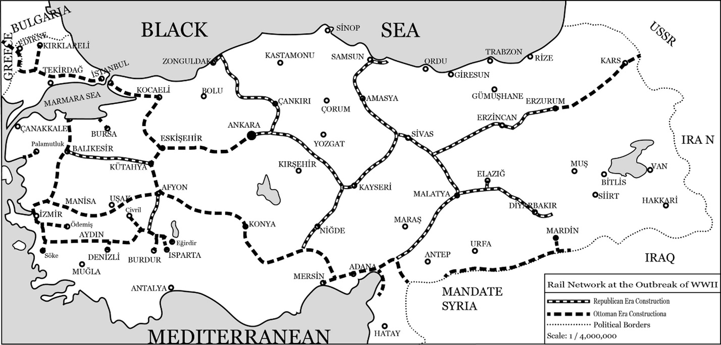
First, the emphasis on “webs” is not accidental. The republican mobilization around iron webs defined itself against the Ottoman model and sought to convert the treelike rail infrastructure at hand into a network proper. Accordingly, the republican railway campaign brought the number of closed-loop rail systems in Turkey from zero to four by World War II (Tekeli and İlkin Reference Tekeli and Selim2004: 314–7). Second, there was a clear shift in the direction of construction. New routes extended from the interior toward the borders rather than piercing inland from the coasts. Third, the policy, in ideological parallel with the tripartite zoning designations of republican settlement laws (Jongerden Reference Jongerden2007; Üngör Reference Üngör2011), differentiated among national hinterlands, borderlands, and frontiers. The railway system generally inched eastward toward terminals in border regions. These major terminals, including Sivas, Malatya, Elazığ, Diyarbakır, Erzincan, and Erzurum, neatly overlapped with strategic sites where senior military headquarters at the divisional, corps, and army levels and supra-provincial authorities such as general inspectorates were stationed.Footnote 10 In this respect, these terminals marked the nation-state’s fortified “internal borders” (Kezer Reference Kezer2014) that served as bridgeheads for domestic repression and assimilation. The regime spun no iron webs beyond these lines of strategic military-administrative concentration, leaving infrastructural development stunted in its deep frontiers to prepare for defense in depth against external threats (Figure 2).
Early Republican railway network.
Note: The map is a composite map created by the author based on several originals published in Demiryollar Mecmuası (a Turkish railroad service journal) in 1938, 1939, and 1955, located at Milli Kütüphane 1956 SB 548.

Consequently, the republican railway program, while expansionist in its thrust and objectives, was more introverted than suggested by both nationalist and critical accounts, as it focused on infrastructural expansion across the national hinterland and internal borderlands, and appeared stricken by the infrastructural uncanny along territorial margins. It sought to create integration, by force or subtler forms of intervention, across the interior spanning core regions to internal borders, while producing friction across land and coastal frontiers through an uneven pattern of infrastructural development for national security that responded to both internal and external threat perceptions.
In their study of the politics of security and infrastructure in the United States, Collier and Lakoff (Reference Collier and Andrew2008, Reference Collier and Andrew2021) describe the spatial logic of postwar US security as “distributed preparedness.” By this, they mean two things: the distribution of defense responsibilities across various levels of government in accordance with the structure of US administration, which they call “emergency federalism”; and the spatial remaking of the nation-state through techniques that view national space from the vantage of the enemy, which they call “vulnerability mapping.” In early Republican Turkey, too, governmental responsibilities at the nexus of security and infrastructure were aligned with the administrative structure, and the regime imagined national territories and populations by seeing them both like the state and like enemies of the state. Yet, unlike the logic of dispersal observed in the US, the Turkish pattern was centralized. In line with the republic’s highly centralized, if personified, power structure, infrastructural decisions about railways and other critical infrastructure were made by the regime’s principal figures. The authority to implement these decisions and operate railways, not least through a vigorous railway nationalization campaign completed by World War II, was concentrated in the hands of a few institutions. In terms of spatial distribution, the rails converged at the core, pressed toward internal borders, and stagnated in frontier regions. Thus, the early Republic’s infrastructural ideology and the skewed posture it produced can best be described as “centripetal preparedness.”
Two imperatives were behind this infrastructural ideology. The first was the early Republic’s quest for ethnoterritorial nation-building, which, in keeping with the policies of the Committee of Union and Progress during the late Empire, aimed to shape a postimperial space inhabited by diverse ethnoreligious populations into a homogeneous nation-state around Turkishness (Dündar Reference Dündar2015; Üngör Reference Üngör2011). In this quest, which frequently took coercive forms, infrastructure like railways was a catalyst for expanding state power and making inroads into potential bastions of resistance, serving as the state’s arm for governance, extraction, and repression. The second was the regime’s anxiety about territorial integrity and survival, which intensified over the 1930s with growing signs of the unraveling Versailles order (Tekeli and İlkin Reference Tekeli and Selim2013: 37–117). In this quest, infrastructure proved uncanny, providing enemies with lines of communication and profitable targets across political borders that were seen less as a wall than a membrane. While infrastructural development across the interior up to internal borders served the first imperative, strategic underdevelopment of frontier infrastructure served the latter.
The state elite’s railway program was therefore aligned with the infrastructural ideology of their military predecessors. Economic motives were not dismissed, but they were now aimed more at domestic market integration and were more likely to be overridden by security rationales. National leaders, almost all men from military backgrounds, often articulated their priorities in their accounts. President Mustafa Kemal regarded railways “as an instrument of security far more important than rifles and cannons,” that could help “transform the homeland into an iron mass.”Footnote 11 İsmet İnönü, the regime’s second-in-command and the railway campaign’s icon, stated in his address at the opening of the Ankara-Sivas line that the question of railways was “one of national unity, national security, national politics, and (…) national independence” (İnönü Reference İnönü2018: 108–9). He also noted that “vivid memories of earlier military campaigns and lessons drawn from World War I exerted an ever-present influence on the railway program” (Reference İnönüibid: 108–9). Field Marshal Fevzi Çakmak, the regime’s military leader well into World War II and the last member of its ruling trio, also played a key role in shaping this infrastructural ideology. He was reputed to have a military cast of mind and a strong aversion to route development or public investment in frontier zones, lest ill-placed routes and misallocations derail state sovereignty.Footnote 12
Locational preferences in routing decisions evinced the ascendancy of military logic and centripetal preparedness under the early Republic. The regime constructed nearly a dozen main lines during the interwar period. With two necessary exceptions, none started from the coast and, in Ahmet İzzet’s words, “stabbed” into the Anatolian heartland.Footnote 13 In most projects, the lines were built, revised, or discontinued on military grounds. When the Ankara-Sivas line was opened in 1930, İnönü’s inaugural address reminded the audience of “the bones of hundreds of thousands of Turks buried where the new tracks crossed,” adding that “Europeans could not have easily ventured into an Anatolian campaign had these rails existed before” (As Reference As2013: 91–3). Later, the line was extended toward the eastern stronghold of Erzurum, though not without a southward dip prompted by Fevzi Çakmak’s interest in reaching the presumed iron deposits in Divriği (Uran Reference Uran2008 [1959]: 208–9). The Fevzipaşa-Diyarbakır line also deviated from its initial course for strategic reasons.Footnote 14 Fevzi Çakmak insisted that the route circle around Elazığ’s center, despite pleas for an inclusive alternative at negligible cost (ibid: 209–10).Footnote 15 Another military-modified line was the Irmak-Filyos coal line, whose route was given a wider arc to preserve its strategic utility in a Black Sea war.Footnote 16 The military also pushed for constructing new rails toward Afyon to incorporate the İzmir-Aydın line into the network.Footnote 17 When the operating company refused to comply, the government took over construction and nationalized the company (As Reference As2013: 149–50). Likewise, following the nationalization of Oriental Railways, the Minister of Public Works explained that the decision was warranted by “the line’s slipshod administration,” which contrasted with “the vital political and military significance of its region of operation.”Footnote 18
The roads not taken were just as illustrative of the regime’s infrastructural ideology as those built and modified. To the south, the initial plan for the Afyon project was to reach Antalya on the Mediterranean coast, but the rails stopped short at Burdur. It was rumored that this final strip could not get the soldiers’ green light. (Aydemir Reference Aydemir2017 [1966]: 430; Pabuççular Reference Pabuççular2020: 1–2). To the north, a narrow-gauge railway to the coal reserves on İstanbul’s Black Sea coast remained idle due to military reservations (Us Reference Us2012 [1966]: 516). To the east, a broad-gauge railway laid by the Russian Empire was not converted to standard gauge until the 1950s because the mismatch in track width provided a scalar friction that could slow down enemy advances (As Reference As2013: 188–9). To the west, a plan to bypass the foreign strip of Oriental Railways gathered dust on the shelves, as trains meandered across Turkish, Greek, and Bulgarian territories until 1971.Footnote 19 Important provincial centers such as Antalya, Gaziantep, Mardin, Muğla, Kars, Trabzon, Urfa, and Van, all located along territorial margins, remained disconnected from the rail network until much later, if ever.
A similar pattern existed in road development. Until the Cold War, roads had been subsidiary to railways, providing rudimentary capillaries to the nation’s iron arteries.Footnote 20 In Antalya, where railway construction had been withheld, the governor built “clandestine” roads unbeknownst to the military because Fevzi Çakmak had prohibited the construction of coastal inroads with an eye on the Italians, Turkey’s suspect neighbor in the Dodecanese (Atay Reference Atay2009 [1961]: 260–1). Road building also slumped in northeastern provinces bordering the USSR, for the army intended to use the region’s mountainous terrain as a natural fortress (Egli Reference Egli2017: 267–70; Us Reference Us2012 [1966]: 660). In Thrace, the main land route was asphalted beyond the halfway point from İstanbul to the border by World War II, but elsewhere in the borderland, the road situation had not changed much since the Balkan Wars (Karabekir Reference Karabekir1994: 81–7). No roads were paved in the Gallipoli Peninsula (İnönü Reference İnönü2017: 153), and, as late as 1953, the roads in the northern sector facing the Black Sea and Bulgaria consisted of trails that, in the words of a regional deputy, “Saint Adam would have recognized had he come back to life.”Footnote 21
To what extent was centripetal preparedness a product of limited state capacity and resources? Without the declassification of military records, still sealed nearly a century later, it is difficult to answer this conclusively. However, throughout the period, the Ministry of Public Works received a hefty share of the national budget, proportionally the highest in all Republican history (Önder Reference Önder1974: 161–85). It boasted a level of prestige and fiscal autonomy matched only by the Ministry of National Defense, leading some cabinet members to quip that Public Works was İsmet İnönü’s “pet ministry” (Uran Reference Uran2008 [1959]: 234). Therefore, financial constraints were not the ultimate driver of infrastructural decisions during the era, and they certainly did not preclude development across frontiers by themselves. Still, they provided strong justification for the belief that infrastructural investment in frontiers was an albatross worth neither the expense nor the security risk. Frontier infrastructures were built sparsely and selectively. Chief policymakers also acknowledged the primacy of military views in infrastructural policy. Hilmi Uran, Minister of Public Works (1930–33) wrote in his memoirs of “the long-standing conflict between economic and military rationales in routing decisions, in which the soldiers always had the final word (ibid: 208–9). This stood in stark contrast to Ahmet İzzet, who had complained of the Ottoman Ministry of Public Works’s penchant for implementing the projects most detrimental to the military.
Industrial policy provides another window into the regime’s priorities, even when resources were available and economic interests were paramount. Here again, military rationales loomed large, particularly with the regime’s turn to etatism and central planning after the Great Depression. Inspired by Soviet planning, the first five-year plan (1934) adopted an import substitution model around a range of new plants in cotton textiles, mining, pulp and paper, ceramics, and chemical industries. The military was an active party in deliberations over soon-to-be-launched industries and their locations (İnan Reference İnan1972: 13). Celal Bayar, then Minister of the Economy, explained that location choice was based on three principles: “cost efficiency, uplift of economic backwaters, and national security” (Tekeli and İlkin Reference Tekeli and Selim2009: 190–1). The latter acted as a veto circumscribing the ambit within which industrial development could proceed.
For example, Professor Orloff, the Soviet adviser who toured Turkey with his team in 1932, recommended Zonguldak as the most convenient site for developing iron and steel industries. The military countered that Zonguldak’s location would expose this strategic industry to naval threats, suggesting the plant’s relocation inland. After an alternative location at Tefen was rejected, the plant was constructed deeper inland in a mountain-covered nook in Karabük, where its operations were barely viable from an economic standpoint (Oğuz Reference Oğuz2007: 40–1). Another expert, Professor Yushkevich, authored a report on iron, steel, and chemical industries. His conversations with officials led him to the understanding that the entire western and southern coastline of Anatolia was ruled out for iron and steel industries (Tekeli and İlkin Reference Tekeli and Selim2009: E262). As for chemical industries, the Aegean coast was suitable, but constructing facilities there was also prohibited. Eventually, Yushkevich suggested Tefen as the best prospect and cited Karabük as his least preferred, yet most secure option. Soon afterward, smoke began billowing out of two plants at Karabük (ibid: E280–1).
Cumulatively, the first plan brought into existence over twenty plants. These facilities were concentrated in the Anatolian interior, within two long mountain ranges that extended parallel to the Black Sea and the Mediterranean. No plants were built beyond this range, with two resource-related exceptions. These included the Zonguldak coal plant and Bodrum’s short-lived sponge industry. The former was Turkey’s sole coal basin with mineable deposits for advanced industry, and the latter had a long tradition in the niche sector of sea sponge harvesting (Figure 3).
Industrial planning in the first five-year plan.
Note: The map is a faithful digitalization by the author based on the original published in İnan (Reference İnan1972).

Even in enterprises outside the scope of central planning, military intransigence affected industry type and location to the point of exasperating some of the regime’s most ardent supporters. Atay (Reference Atay2009 [1961]: 674–6), the regime newspaper’s head columnist, claimed that military zoning policies were suffocating the Gulf of İzmit. His radio broadcasting venture collapsed for failing to obtain military approval to install antennas due to fears of espionage, and he was openly critical of those “who thought the defense of the homeland benefited from fewer railways and roads” (Reference Atay1932: 4). In southeast Anatolia, when citizens confronted the Minister of the Economy about why no plants were being built in Diyarbakır or Urfa, he urged them to call Fevzi Çakmak and ask for his permission themselves (Madanoğlu Reference Madanoğlu1982: 125–6). Aydemir (Reference Aydemir2017 [1966]: 453), the head of the Industrial Investigation Committee, acknowledged that military attitudes had “an undue influence on industries to a degree that defied explanation.” When war broke out in 1939, Turkish war readiness was thus firmly anchored in centripetal preparedness.
Wartime infrastructural capacity
In his study of World War II, Deringil (Reference Deringil1989: 187–8) likens Turkey’s wartime strategy of “active neutrality” to “cascading defense works around a citadel.” The successive walls encircling the citadel were made of “arguments of military unpreparedness” and “sincere pleas” for a joint campaign alongside the Allies at a more suitable time. These lent Turkey the credibility to resist the strong Allied insistence that it must come to war. Yet, Turkey maintained its nonbelligerent status until the war’s tail end, carving for itself an island of hot peace within embattled Europe and the Middle East, despite enormous upkeep costs. Infrastructure was central to the wall of arguments Turkey raised to infinitely delay its seemingly inevitable war entry. All the parties involved in Turkey’s imminent war talked about infrastructure. The Turks bemoaned its inadequacy; the Allies revamped its capacity; the Nazis gauged its efficacy. The war went on, infrastructural capabilities improved, and Turkey stayed put. Infrastructural capacity, or its lack thereof, equipped Turkey with the plausible excuse that its time for war was not yet ripe.
Turkey’s infrastructural capacity for war, particularly for an offensive, was indeed inadequate. Aydemir (Reference Aydemir2017[1966]: 132–4), then head of the oil affairs commission and adviser to the rationing board, noted that Turkey’s fuel tank capacity was theoretically 100,000 tons, but wartime stock levels frequently dipped below weekly demand. The annual cement production stood at 380,000 tons, while per capita output was six meters for cotton textiles and four kilos for sugar, well below the level of countries under Axis occupation. The iron and steel industry had not yet found its footing; shipyards existed only on paper; the country relied on a single basin for coal production; and the army fielded a patchwork fleet comprising twenty-seven types of trucks. The daily demand for grains and forage for civilian and military use was 1,000 tons each, but on some days only two tons of provisions could be supplied (Reference Aydemiribid: 204). Road conditions were dire, and according to a transportation officer, the rail network could transfer an allied French division from Syria to Thrace in six months (Kocatürk Reference Kocatürk1999: 216).
For the Allies, who wanted to see Turkey fighting offensively on their side or, at worst, offering them a base of operations against the Axis, Turkey’s limited infrastructural capacity was a problem. Thus, they committed vast resources and provided expertise, equipment, and credit to facilitate Turkey’s war entry, with the British leading the charge on the assistance front. Foreign experts flowed into Turkey to survey its bridges, roads, aerodromes, and ports, while supervising and participating in Turkish efforts to develop transportation infrastructure.Footnote 22 According to a 1945 calculation, British spending on Turkey’s roads and aerodromes had reached 10 million pounds, excluding ports, a major aspect of British endeavors (Tekeli and İlkin Reference Tekeli and Selim2013: 661).
For Turkish leaders, who wanted to avoid the war altogether or, at worst, fight a defensive one, Turkey’s limited infrastructural capacity was a mixed blessing. On the one hand, Turkey maintained a massive army and developed infrastructure behind its defensive lines. As these lines shifted with the war’s progress, from forward border areas to rear positions in the interior, so, too, did the type and focus of infrastructural investments.Footnote 23 On the other hand, state elites recognized that rapid advances in capacity building could facilitate Turkey’s war debut by removing a key argument for its neutrality. Essentially, the Allied pressure to expedite Turkey’s engagement contradicted Turkish leaders’ reluctance about it. They wanted to bolster readiness at their own tempo. This proved sluggish enough to earn the Turkish strategy the moniker “Operation Footdrag,” in reference to a British war plan to hasten Turkey’s war entry (Weisband Reference Weisband1973: 146–66). Overall, arguments around infrastructural capacity became a greasy pole the Allies tried to climb to pull Turkey into the war, while Turkish leaders lubricated it further to slip out of reach.
For the Nazis, who wanted to win Turkey over by force or diplomacy or, at worst, ensure its neutrality, Turkey’s limited infrastructural capacity was a deterrent. Nazi leadership specifically flagged Turkey’s inadequate infrastructure as a point of concern. Nazi war plans against Turkey existed since the mid-1930s, and Turkey’s occupation remained an option until summer 1941 (Koçak Reference Koçak2015: 534–5). In Nazi calculations, Turkish forces in Thrace could not match their mechanized war machine due to the lack of defensive depth, air cover, and natural defenses in the borderland. However, they also anticipated that their prospects could take a different turn after crossing the Turkish Straits. The Turks could strategically withdraw to the interior to take a stronger footing in Anatolia and slow the German advance by cutting off supply lines through a controlled retreat toward the southern Taurus range. Then, German forces could be incapacitated by Turkey’s poor infrastructure, finding themselves mired in the depths of Anatolia to fight a crawling war of attrition against a stubborn enemy (Papen Reference Papen1952: 470–2). Although Turkey would eventually be subdued, time was of the essence for the Nazis, and a campaign in Turkey could cost them operational tempo and time better spent on higher objectives. When the Nazis weighed the options of invading Turkey or the USSR in 1941, they thus chose the latter.
Ultimately, Turkey weathered the war financially and socially scarred, but physically unscathed. If national leaders succeeded in their strategic objective, this was in part because they tempered, rather than rapidly expanded, infrastructural development through a calculated policy. Their regime was battle-tested. So was their infrastructural ideology, which engineered infrastructure within a crisis framework of sovereign state security.
Postwar developments
Although a latecomer to World War II, Turkey had a head start on the Cold War. Months before peace, the Soviets informed Turkey of their intention not to renew the 1925 Non-Aggression Pact. The war of nerves flared up when the Soviet Foreign Ministry intimated that a change in the Turkish Straits regime and a land concession on Turkey’s Caucasus borders might help them reconsider their decision. Shortly thereafter, Stalin broached these wishes with the Allies at Potsdam. The crisis peaked when the Soviets formalized their demands for a joint-operated base near the Straits and the modification of the Straits regime. With neighboring Greece in civil war, Bulgaria under Soviet control, and Iran under drawn-out Soviet occupation, Turkey dreaded Soviet encirclement and retained its war footing. Its distress call found a resounding response from the US, which included Turkey in the Truman Doctrine and the Marshall Plan.Footnote 24
With this realignment, the question of infrastructural ideology reared its head again. The US assistance included a highway program (Adalet Reference Adalet2018: 85–157), which laid the foundations of Turkey’s Public Roads Administration (PRA) and heralded a policy pivot from rail to road. It also reignited a debate over infrastructural ideology echoing down the century: To what primary end must infrastructure be built, and what type of infrastructure would correspond to this? What spatial disposition of infrastructure and tempo of construction would best serve this end? Is poor frontier infrastructure bad because it is a drag on state power and defense, or good because it is also a drag on offense? Headed by Vecdi Diker, the PRA’s civilian wing wanted to build roads all around the country with the conviction that Turkey would be barren of development and life without roads to economic backwaters. Led by Salih Omurtak, the Turkish Chief of Staff, the military wanted to restrict roadwork to strategic routes in the interior, as they believed Turkey could not be defended with roads abutting the Soviet border (KGM 2007: 29–30; Yollar Türk Milli Komitesi 1998: 43, 75–7).
Diker claimed soldiers were eventually convinced that the program’s scope must exceed their narrow interpretation of infrastructure as an avenue for national security. Still, the nine-year program of 1948, scheduled in three phases, reflected a compromise that only slightly revised centripetal preparedness.Footnote 25 The first phase had a clear inward orientation, envisioning no construction on Turkey’s European and Caucasus borders and deferring suspect routes to later stages. As late as 1951, military officials insisted that roadwork east of the Erzurum-Muş-Bitlis-Siirt line near the Caucasus border be sidelined in favor of strategic routes, and that efforts in vulnerable areas be limited to cosmetic upgrades (As Reference As2013: 371–3). Throughout, civilian and military officials debated infrastructural ideology, with arguments rooted in different conceptions of sovereignty. The civilian argument was captured in the motto that decorates PRA offices to this day: “Wherever you can’t go is not yours.”Footnote 26 Another plaque could be commissioned by the military to express the obverse: “Wherever they can’t go is still ours” (Figure 4).
Turkish Road Programme.
Note: The map is a faithful digitalization by the author of the original published in As (Reference As2013).

Caught in this debate, American civilian and military personnel of the Joint American Mission for Aid to Turkey (JAMMAT) leaned toward their Turkish counterparts. Because JAMMAT was essentially a military enterprise, the results fell closer to military perspectives. Defense planners envisioned that the Soviets would overrun Turkey’s northwestern and northeastern borderlands, and Turkish forces, after delaying operations, would withdraw in successive stages toward a final fallback position on the southern coast.Footnote 27 Therefore, planning privileged southern and central Anatolia. New storage and port facilities were built in İskenderun, assuming that “all supplies for Turkey would have to be handled through the Gulf of İskenderun in wartime.”Footnote 28 İskenderun also marked the initial point for first-class military roads to Ankara-İstanbul and Erzurum, the latter being Turkey’s first experiment with mechanized roadbuilding.Footnote 29
This infrastructural emphasis on inner and southern Anatolia entailed bypassing northwestern and northeastern frontiers. The US Army engineers, active in the Near East since 1947, omitted these areas from their mission (Grathwol and Moorhus Reference Grathwol and Donita2009: 17–28). Plans for the Turkish Air Forces’ development and deployment ignored Thrace, citing “the possibility of early loss due to enemy ground action.”Footnote 30 New fighter and bomber bases, depots, and training facilities were all established inside a security perimeter that cordoned off Turkey’s Soviet frontiers.Footnote 31 Plans for new oil pipelines ruled out interconnected lines in the Marmara Sea and around İzmir, as these areas were deemed “vulnerable during wartime; hence no money should be expended on their construction.”Footnote 32 All Turkish main supply routes, planned or operational, seemed to stop, as if by miracle, a few steps short of Turkey’s Soviet frontiers. Military units stationed in Thrace were “equipped with the oldest equipment available,” reflecting the conclusion of a detailed military survey that it was “necessary to surrender the greater part of Thrace in order not to jeopardize the overall defense of Western Turkey.”Footnote 33 Another survey on eastern Anatolia, where defensive prospects seemed marginally better, included a full section on demolition points along regional routes.Footnote 34 As Turkey’s infrastructural gravity bent further inward, its Soviet frontiers became zones of abandonment to be traded against time in war (Figure 5).
Turkish main supply routes dated 9 December 1951.
Note: The map is a faithful digitalization by the author of the original, held at NARA RG 334/NM-16 263-B, Box 132.

Local residents were aware. Again, the roads were a telltale that they had been rendered marginal citizens inhabiting national security buffers. A deputy from Thrace questioned when the regional roadwork moratorium prompted by “well-known reasons” would end.Footnote 35 Another deputy, alluding to the designation of eastern provinces as zones of deprivation (mıntaka-ı mahrume), identified Thrace as a zone of abandonment (mıntaka-ı metruke) and called for new roads to lift the self-inflicted siege of the borderland.Footnote 36 A deputy from eastern Anatolia brought the road program’s tricolor map to parliament to rail against “the backward mentality” that condemned entire border regions to underdevelopment.Footnote 37 In the southeast, where infrastructure echoed a deeper history of racialization and state violence, Kurdish citizens marched against their infrastructural deprivation as late as 1967 (Adalet Reference Adalet2022; Beşikçi Reference Beşikçi1992; Gündoğan Reference Gündoğan2011; Yadırgı, Reference Yadırgı and Michael2019). Such infrastructural aspirations were categorically foreclosed, more so and for longer for Kurds subject to suspicion, surveillance, and repression, until the mid-1950s, when NATO admitted Turkey and adopted a nuclear-based forward strategy in Europe.Footnote 38 Turkey adjusted to the air-nuclear age where air superiority became a prerequisite for military success and nuclear arms a guarantee of mutual destruction. As war became less earthbound, more voluminous, and apocalyptic, the ideology of centripetal preparedness, which tailored infrastructural development to the dual imperatives of ethnoterritorial nation-building and elastic defense, grew obsolete.
Conclusion
By examining the Turkish historical experience in dialogue with scholarship on infrastructure, borderlands, and the state, this article complicates an understanding of state power and infrastructure in terms of a circular ontology. It demonstrates how maximal projection of infrastructural power to the margins of state power, even when resources allow it, may not define the policy horizons of actors governing infrastructure. While state actors regard infrastructure as a conduit for power, they may also recognize it as capacious and ambivalent, as infrastructure can accommodate competing power projections, unravel the social orders it undergirds, and appear uncanny to those who use or build it. Therefore, they might clash over defining the objectives, disposition, tempo, and modality of infrastructural development. Crisis perceptions throw these clashes over infrastructural ideology into sharper relief.
The Turkish experience also illustrates how infrastructural dangers might derive from reasons other than infrastructure’s susceptibility to ruination through aging, disaster, human error, or neglect. If infrastructure appeared uncanny in the Turkish case, this had less to do with decay and disrepair than with its well-maintained, active presence amid a crisis of sovereign state security. These risks were perceived and experienced differently across groups. An old bridge designated for demolition may have posed risks for borderland villagers, but it could also be considered a security asset by state actors.
Finally, exposing infrastructural ideology through studying-up is crucial to grasping how citizens experience social inequality, spatial stratification, and violence in everyday life. Turkish infrastructural policy has had uneven and lasting consequences, particularly for borderland and frontier communities. While infrastructure’s strategic concentration around internal borders targeted the nation-state’s suspect citizens, its underdevelopment rendered frontier lifeworlds abject, like a proverbial reptilian tail that could be sacrificed in critical wartime. As centripetal preparedness defined infrastructural policy and made underdevelopment a surge protector for national security, Turkey’s infrastructural posture sagged at its territorial margins and stiffened at its core. Without confronting how space is not only the object of infrastructural policy but also its uneven product, we cannot understand how nuclear infrastructures arrived in Turkish borderlands before even basic roads, railways, or industrial plants. Unless we reckon with infrastructural ideology and how it formed a critical wedge between national hinterlands, borderlands, and frontiers, we can hardly understand how whole regions in Turkey came to be casually identified as zones of abandonment or deprivation by citizens and state actors alike.


 Open access