




Fundamentally, this paper is an intervention on the crucial importance of the geophysical when situating and defining the space of the Maghrib.Footnote 1 Considering the age-old question, “Where is the Maghrib?,” to borrow the title of an introduction to a recent special issue of Arab Studies Journal, requires attending to the Maghrib’s unique liminality, its “interstitial position between different continents and transnational cultural formations, a variety of linguistic, ethnic, racial, religious, aesthetic, and other cultural elements [that] constitute the Maghrib. This position as a space-between-spaces makes the Maghrib a hub for human hybridization, literary creolization, artistic miscegenation, and cultural cross-pollination.”Footnote 2 Although these cultural and identity-based narratives are crucial, I argue that framing the Maghrib’s liminality in terms of “space-between-spaces” concurrently requires accounting for the region’s geophysical dimension—its topography, morphology, volume, geological density, and material agency, among other markers.
In this essay, I propose to conceptually restore North Africa’s terrains (by which I mean its natural expanses, either terrestrial or aquatic, taken in their planetary, material resonance) to the deep time of geophysical forces. This gesture reveals the terrestrial scope of the well-known trope of “Maghribi connectivity”—a function of its liminal, interstitial position, here rethought through the elemental agencies of its natural spaces. Material ecocritical methodologies have proposed new ways of thinking about the relationship between people and place, in a manner championing “becoming-with” (the human “becoming with” the more-than-human) rather than simple domination.Footnote 3 Building on this model, I rethink Maghribi connectivity within a materialist perspective by examining contrasting mappings of the region in light of the political narratives they produce. Drawing on material ecocriticism and theories of geopower, my argument challenges the dominant mapping of the Maghrib along the coordinates of geographical emplacement, historical teleology, and political frameworks—coordinates that have been implemented through border-making practices evidenced in cartography since the colonial era. In contrast, I underscore the crucial importance of centering the Maghrib’s elemental spaces (the Sahara and the Mediterranean) to devise new spatial narratives mindful of the land’s geophysical might beyond an extractivist, colonialist scope.
With that aim in mind, I spotlight the mapping practices performed by illegalized migrants crossing North Africa on their way to Europe. These practices manifest in the form of a countermap, a map of the desert’s geophysical terrain aiming to destabilize and resist systems of border control that enable the biopolitical suppression of unwanted migrants on the far edges of Europe. This focus rescripts Maghribi borders as elemental borders—geophysical spaces endowed with agency that redefine North African terrains beyond colonial conceptions of inert boundaries and empty space awaiting exploitation. Through its centering of the Sahara Desert, the countermap expands the scope of mapping practices focused on the Maghrib. It reactivates trans-Saharan connectivity to southern regions of the African continent, moving beyond well-traveled trade routes and colonial arrangements. Drawing attention to the encounter between human and geophysical forces, the countermap queries the political and aesthetic implications of making their imbrications visible. Ultimately, it brings to the fore the critical insights that an elemental perspective on North African space enables—and the new relation to North African terrains it makes possible, in a gesture that opens up the Maghrib designation to the expanded theoretical horizons of Tamazgha.
On “Maghrib” and Borders
Situating the Maghrib has historically been an elusive task. Determining the Maghrib’s boundaries engages colonial geographies, political narratives, geopolitical struggles, poetic imaginaries, indigenous worldviews (which have been mostly neglected), and, I would argue in the context of this essay, the consideration of geophysical forces. It also is to weave a twofold reflection on both time (human and deep time) and place.
In The Invention of the Maghreb, Abdelmajid Hannoum traces the full-fledged emergence of the “Maghrib” designation to the days of French colonial occupation in the 1920s. As colonialism took root, the structure and technology of colonial power came to define the epistemological rules of engagement. North African space was recorded and transformed through technological, ideological, and scientific categories that had stemmed from centuries of historiographic, geographic, linguistic, and other forms of Orientalist inquiries into the region. Military conquest shifted the balance of power toward the colonizing power and gave France the upper hand in executing its vision of the land and its people, in the manner needed to cement its colonial regime. The birth of the Maghrib was therefore accompanied by a “divorce. . . from the larger region now referred to as the Middle East on the one hand, and from the region commonly called Africa on the other. Indeed, the Maghreb region seemed to be neither.”Footnote 4 The concept of the Maghrib that underpinned the establishment of French rule was racially delineated, setting into tension a “white” North Africa and an African continent from which it was to be isolated and differentiated.Footnote 5
The first maps produced in the wake of the 1830 French conquest of Algeria furthered these colonial imaginings. Presenting deliberate similarities with the maps of ancient Greece and Rome for scientific as well as ideological reasons, they reinforced the narrative that read the French incursion as the continuation of millennia-old dynamics.Footnote 6 Much could be said about the technologies of power implemented to realize these first maps. For the purposes of this argument, however, I will simply focus on the use early imperial cartography made of the Mediterranean and the Sahara, framing them as empty spaces improper for human endeavors in an effort to buttress broader imperial narratives of control over marginalized spaces.Footnote 7
The Sahara was imagined as a limit between two geographical and racialized spaces. Yet the Sahara also was perceived as a space unto itself, one supposedly excluded from the purview of human morality, a “barren” space only redeemable through its brash exploitation.Footnote 8 In this configuration, the Maghrib lay halfway between productivity and waste, so-called “civilization” and “barbarity”: the Mediterranean acted as a connector joining the Maghrib to Europe, whereas the Sahara protected North Africa from the supposed depravity of the lands to the South. In this reading, both elemental spaces were the boundaries against which the space of the Maghrib was defined. Born of a web of geographical imagination and knowledge production proceeding from multiple sources, these largely fabricated perceptions of space would soon come to constitute colonial reality.
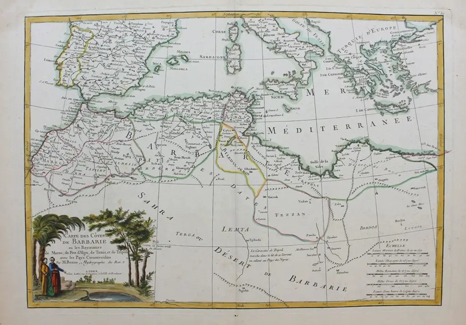
Let us consider Rigobert Bonne’s 1762 “Carte des côtes de Barbarie ou les Royaumes de Maroc, de Fez, d’Alger, de Tunis, et de Tripoli avec les Pays Circonvoisins” (Fig. 1).Footnote 9
Rigobert Bonne, “Carte des côtes de Barbarie ou les Royaumes de Maroc, de Fez, d’Alger, de Tunis, et de Tripoli avec les Pays Circonvoisins.” c. 1762. From Atlas moderne (Paris: Jean Lattré).

Although predating the 1830 French conquest of Algeria, the map partakes of the same Orientalist system of knowledge that eventually led to the successful colonial subjugation of the region a few decades later. In those days, Barbary, as North Africa was known, had been part of the Westward territorial expansion of the Ottoman Empire since the early 16th century, with the exception of what the cartographer designates as the “Royaume de Maroc” (Kingdom of Morocco). The map’s division of Barbary into several royal domains follows the cartographic norms of a century in which kingdoms were seen as the natural political unit.Footnote 10 Yet this segmentation of space into nondescript “kingdoms” eludes the Ottoman roots of the regencies included in this appellation. Bonne’s map only acknowledges a geographically restricted, blank “Turquie d’Europe,” neglecting to mention its counterpart, “Turquie d’Asie,” shaped by imperial deployments over central Asia and the Middle East. In contrast with this erasure of Ottoman power, the degree of detail exhibited on the Western portion of the map crafts a visual narrative that closely associates the Maghrib with Europe. The meticulous recording of cities and bodies of waters on both Western shores of the Mediterranean highlights a putative connectivity between the two: by geophysical elements but also cities. In the map’s geographical imagination, these are two spaces functioning in tandem. Taking the point further, the focus on southern Spain, presented here as the European counterpart to the Maghrib, hearkens back to the longstanding history of Andalusian intermingling, which the Reconquista originally meant to sweep over North Africa was supposed to bring to completion under the banner of Christianity. From this perspective, the Mediterranean serves as a connector, a point of contact. In contrast, Turkey remains woefully blank, as does the territory lying south of the Maghrib: the “Sahra” or “Désert de Barbarie.”
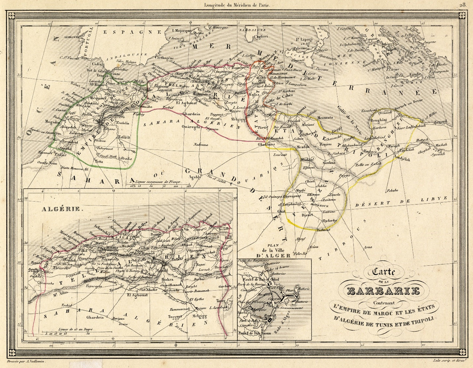
Let us now turn to a map postdating the 1830 French conquest of Algeria. Alexandre Vuillemin’s 1843 “Carte de la Barbarie Contenant l’Empire de Maroc et les États d’Algérie, de Tunis et de Tripoli”(Fig. 2) was published a mere five years before Algeria was departmentalized, at a time when Emir Abdelkader’s resistance campaign had just been definitively crushed.Footnote 11
Alexandre Vuillemin, “Carte de la Barbarie Contenant l’Empire de Maroc et les États d’Algérie, de Tunis et de Tripoli,” c. 1843. From Atlas universel de géographie ancienne et moderne à l’usage des pensionnats (Paris: Lefèvre).

Unsurprisingly, the map’s representation capitalizes on the establishment of the French colonial regime in Algeria, an institutional structure still lacking in the two future protectorates of Tunisia (established in 1881) and Morocco (established in 1912). The same connectivity and level of detail as in the Bonne map is present here. Yet, interestingly, it only encompasses the three territories that will constitute the French Maghribi colonies (Morocco, Algeria, and Tunisia, respectively circled in green, purple, and red) with the addition of current-day Libya (in yellow), all very desirable territories from an expansionist perspective.Footnote 12 However, this time Europe is blank, as is the Sahara, leaving the Maghrib in an insular position as a self-enclosed and incommensurable island lost between two seas of water and sand, a representation echoing the trope of Jazīrat al- Maghrib, the island of the West, or the Maghrib as an island, a construct circulating since the 9th century and echoed in Algeria’s Arabic name, al- Jazā’ir.
The Maghrib’s “islandness” is deployed along two interrelated axes, what Peter Kitlas calls the Maghrib’s “intriguing paradox: the inherent possibility within an island for simultaneous isolation and connectedness.”Footnote 13 In his argument, Kitlas takes his cue from Philip Naylor, who situates the Maghrib between two seas: “the Mediterranean and the Sahara [which] have insulated and isolated peoples but have also channelled transcultural current[s].”Footnote 14 In this perspective, connectivity articulates the Maghrib to surrounding geographical constructs, but it does not subjugate it to them. Endowed with a certain degree of autonomy, the Maghrib here reflects both the ordering logic of its contiguous spaces (the Mediterranean; the Sahara) and an irreducible form of localism—although always in relation to the lands lying beyond its outer edge and always in a manner exclusive of indigenous toponymy and forms of knowledge.
The argument I am developing here complicates these colonial readings of the Maghrib—in turn isolated and connected by the Sahara and the Mediterranean. It also contests postcolonial narratives that view the Maghrib as either irremediably tied to its former European metropoles or fully subsumed within the ethos of Arab nationalism. It reveals another understanding of borders in the context of global migration, one that spotlights the agency of elemental border spaces, not just as lines of demarcation or flat planes of connectivity, but as agents in their own right.
Countermapping the Maghrib
My reflections start from the ever-increasing incorporation of natural spaces in the process of border securitization carried out by the European Union in a global migratory context. This instrumentalization of nature to stem migration overlays new geopolitical coordinates onto purportedly inert Maghribi geophysical spaces.
Like the Mediterranean Sea drowning scores of illegalized migrants, the space of the Sahara operates within Europe’s strategy of border externalization, its materiality enacting the same biopolitical suppression of undesirable migrants that European borders are meant to effect. From a necropolitical viewpoint, one might even venture that the Maghrib’s elemental spaces now play a more crucial role in regulating clandestine migration than the official borderlines born of European nation-building. The Sahara can therefore be considered to act as the southernmost border of the European Union—a new shifting and sliding border, geophysical in nature, whose very action challenges the authority of any cartographical border-making practice. Thinking of the Maghrib elementally in this way spotlights the region’s shape-shifting quality: the ways in which it exceeds the strict coordinates of geographic positioning and the political uses to which they are put, a dynamic that undermines the enduring stability and relevance of the very category of the Maghrib. In a way, geophysics here trumps geography, and an elemental outlook opens the door to a rethinking of the restrictive territoriality of nations and borders, a critical move highlighting their vulnerability in light of geophysical might.Footnote 15
The concept of geopower emphasizes the Earth’s ability to shape order from various conflicting forces, ranging from geophysical and biophysical to human. Elizabeth Grosz argues that, although geopowers can be entangled with political dynamics, they resist full control by political or economic systems like capitalism.Footnote 16 Geopowers precede and surpass biopolitical designs, as illustrated by the intrinsic resistance of the natural elements, like water and deserts, to human enterprises involving them.
If maps exercise and perform control, a focus on the natural spaces bordering the Maghrib redeploys cartographic imaginaries from the marginalization of the region’s natural terrains to their integration into key epistemological flashpoints in a global, geopolitical landscape. Maghribi liminality is here recoded beyond its cultural potential for hybridization. In our geophysical perspective, the Maghrib is not simply the land that lies between the Sahara and the Mediterranean: what is neither one nor the other, what is defined through the dialectic of its geopolitical borders. The Maghrib as it is illuminated here is in fact precisely what includes both the Mediterranean and the Sahara, their lack of productivity in the value/waste paradigm, but also their elemental resistance to human designs. For although water and arid spaces perform necropolitics, their magnitude also defies control. This renewed perspective opens up the region to planetary environmental dynamics in a way that evades the exiguous heritage intrinsic to the “Maghrib” toponymic designation. In our reading, North Africa stretches beyond surface-level mappings of territory and power indebted to colonial or extractivist logics. No longer serving as a blank canvas sustaining imperial projects of world-making, North African space is resemanticized as Tamazgha, in a move cognizant of the inextricable continuities between human and more-than-human—and of their co-implication.
This planetary model calls for a renewed mapping practice that replaces the bird eye’s view representation focused on relief and connectivity deployed along trade routes with a more experiential approach to mobility and terrain. Let us examine what a contrapuntal representation of land in a cartographic paradigm mindful of human and more-than-human interactions might look like; one crystallizing the subjective experience of mobility across elemental terrains, a map countering concepts of mobility harnessed to paradigms of migrant (un)desirability. In other words, a countermap staging resistance to the violence of borders and exclusive world-making politics.
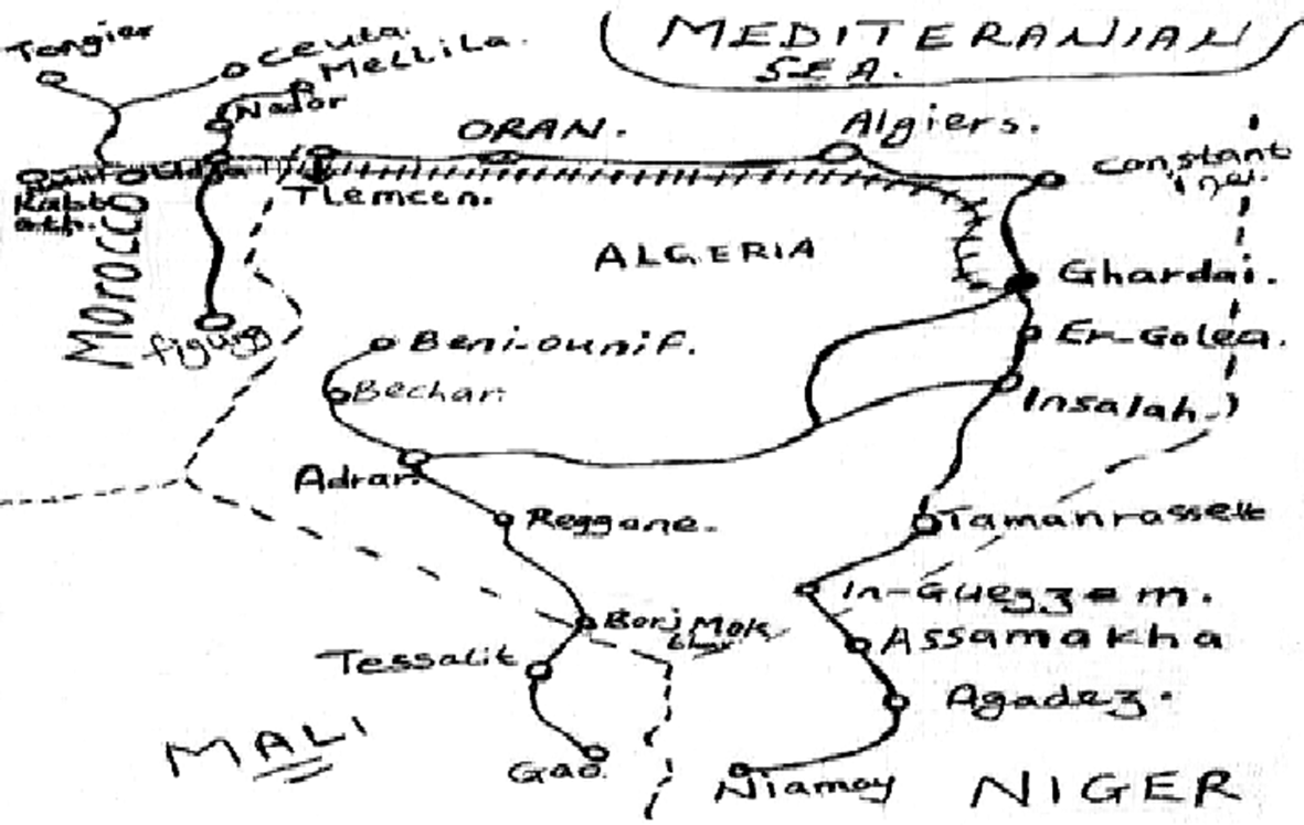
The next map (Fig. 3) was drawn by an anonymous migrant with the purpose of undermining border regimes of control and eradication, primarily by increasing the chances of survival for fellow migrants facing life-threatening natural conditions during their crossing of the Sahara Desert on the way to Europe.Footnote 17
Hand-drawn migrant map of the Sahara and the Maghrib. Still from Crossroads at the Edge of Worlds (documentary; Charles Heller, 2006).

The countermap appears at minute 5:00 of Charles Heller’s 2006 documentary, Crossroads at the Edge of Worlds, produced as part of the “Maghreb Connection: Movements of Life across North Africa” collaborative art research project curated by Ursula Biemann in 2006. Bringing together various in-depth examinations of key Western Maghribi sites on the migration route from sub-Saharan Africa to Europe, the 37-minute film foregrounds the journeys of various migrants whose reliance on informal, transnational networks of solidarity offers a new understanding of Maghribi-African connectivity. As a later article featuring the countermap recounts, the sketch was found alongside a collection of photographs of captured migrants on a disk that was given to the filmmaker in 2005 during a field trip to Oudja, a city on the Moroccan-Algerian border to which migrants like those featured in the film are routinely refouled.Footnote 18 The map, taken from the pocket of an unnamed migrant, does not provide additional insight into the identity of its creator, although the document’s inclusion on the disk intimates that the mapmaker’s hopes to migrate to Europe were likely dashed. Without clear authorship to shape its reception, the countermap endures as the recipient of accumulated knowledge extending far beyond the experience of one single person; the erasure of its author only serves to emphasize the collective effort behind the information-gathering that underpins this informal cartography.
On the countermap, mapping as an arbitrary practice mediating the enforcement of borders comes undone; the intrinsic porosity of national boundaries is exposed. Borders are reduced to dotted lines, remnants, traces of a former order that no longer holds full sway. The countermap forms a counterarchive of mobile knowledge, one reflective of the lived experience of movement by migrants, of their ways of being and resisting on the edge. Communally assembled and passed down from migrant to migrant in a gesture of solidarity, through acts of transgression and political agon, the map charts a path toward a politics of life that undermines the necropolitical uses to which Tamazgha’s natural spaces have been put by the disciplining forces of Western modernity.
Favoring political practice over figuration, a countermap is “not a geographical map but a history book.”Footnote 19 As Casa Cortes and her coauthors have argued, the routes countermaps display are inseparable from the experience of migration; they do not predate it but rather emerge through the very process of mobility. Traced in real time from the experience of displacement across the desert, these routes are forged through necessity and memory, shaped by the imperative to survive. Their very existence testifies to the creation of a collective form of knowledge that crafts new spatial narratives mindful of the land’s geophysical might, of the tactical need to coexist with it in a manner attentive to its potentially lethal agency.Footnote 20 The countermap highlights the geophysical “border” as agent, but also connector. The desert belies the idea of a border, of a solid regimentation of space, of fixed boundaries buttressing sovereignty and control. It undulates in the shifting sands, sustaining the rich layers of life that pervade it. The countermap brings to the fore a space to be reclaimed from its supposed emptiness, a space brimming with the life forms pulsating through it. It models a novel relationship to the desert land, a harmonious coexistence mindful of nature’s incontrovertible power and the subjective experience of confronting and negotiating that might. It supposes an avowal of human frailty that undercuts conceptions of anthropological exceptionalism and its ecocidal, extractive logic. In this way, it paves the way for Tamazgha.
On Ecological Existence and Solidarities
In this essay, I have sought to answer the question “Where is the Maghrib?” by moving beyond abstract processes of space-making and bordering. Drawing inspiration from geophysical spaces and forces, I have endeavored to restore the North African land to its geological density and its entanglements with human agency. As extractive logics restrict indigenous rights to the land and its use, restoring the focus on elemental forces emphasizes a nonhuman ecology, whose agency surges from the depth of geological time, deep under the surface of the earth. This shift toward geopower dislodges extractiveness as an all-encompassing logic to the benefit of decentered modes of human and more-than-human relationships. Ultimately, it opens up space to rethink the Maghrib designation in terms of Tamazgha, a concept restoring the land to its “becoming with” position, to borrow Donna Haraway’s notion, and centering disappropriated native populations. It is envisioning another North Africa.
By undoing top-down interventions into the historical production of place through borders and mapmaking, an elemental outlook paves the way for ground-level reconfigurations of social and spatial relations for collective ends.Footnote 21 More fundamentally, it opens space for the inscription of local forms of life erased from official narratives. In this way, the countermap becomes a tool of reclamation for those suppressed by conventional cartographies. Displacing geopolitical forces and colonial constructs, the wayward mobility captured by the countermap performs irreverent agency. Staving off death at the mercy of the elements, it constructs an informal archive of knowledge grounded in firsthand experience of the materiality of geophysical spaces. By stitching actual knowledge onto abstract representation of space, the countermap reverses the territorial logic of conquest, its North to South movement of domestication and exploitation, into a South to North itinerary of liberation. It infiltrates the supposedly static space of the desert, laying claim to it through a continuous negotiation against its physical might. Reintroducing the human dimension of mobility into cartography, it roots space-making in situated endeavors rather than distant, global designs. By reading the desert in its granular materiality, the countermap is an exercise in solidarity between “aventuriers” (adventurers, as the migrants in the documentary film are called), but also with indigenous populations (an occasional passing truck supplying water and other essentials to allow migrants to survive another day). This connectivity spells a new form of social inscription—alternative patterns of spatial and social legibility and belonging that supersede static transnational boundaries.Footnote 22 Through its subjective, experiential aesthetics, the countermap points toward ecological coexistence, a boundless form of solidarity.

 Open access

