

In November 1934, Japanese disaster researcher Terada Torahiko (1878–1935) contemplated the future of typhoon warning systems. Terada primarily viewed the ocean horizontally, with a focus on early detection of typhoons in the Pacific Ocean before they reached Japan. He had read about a US company’s proposal for stationing floating airports – termed seadromes – across the Pacific. These seadromes, acting as refueling stations for airplanes with still limited ranges, would significantly increase their passenger and freight capacities by reducing the need to carry large fuel reserves over long distances. Although skeptical about the realization of seadromes, Terada envisioned that within fifty to a hundred years, floating offshore observatories would become widespread. These observatories would gather weather information, an activity that, along with celestial navigation, had historically constituted the very limited upward-oriented interactions between vessels and the oceanic environment. But more importantly, in horizontal space, these floating observatory islands could detect approaching typhoons earlier than coastal observatories in Japan and report them via radio, thereby extending preparation time.Footnote 1 The US company behind the seadrome concept also saw weather observation as vital, not only for air traffic safety but as a potential revenue source by selling weather data via radio to governments, shipping firms, and others.Footnote 2 Today, about ninety years after Terada’s speculation, satellite imagery has become the most important tool for tracking typhoons and gathering various oceanic data. This technological evolution draws attention to the resulting spatial shifts in vertical connectivity among the sea surface, the atmosphere, and satellite orbits in outer space.Footnote 3 The floating seadromes, with their horizontal runways – horizontal space for acceleration and slowdown being essential for safe airplane takeoff and landing – were never constructed. The unstable, turbulent, and forceful nature of many sea surfaces created a multitude of problems, discouraging horizontal arrivals at and departures from most types of artificial islands. Yet, from an oceanic-vertical perspective, the unrealized seadrome proposal initiated a spatially very different trajectory, leading to multiple artificial islands for the vertical takeoffs and landings of helicopters and rockets.Footnote 4 The vertical connections among the sea surface, airspace, and outer space opened new transportation avenues for goods, people, satellites, and even the dire possibility of nuclear missiles launched by submarines. This verticality also enabled novel insights into the sea surface and water column once remote sensing satellites began orbiting Earth.Footnote 5
In this chapter, I investigate the role of upward-oriented vertical orientation in constructing artificial islands, marking another spatial aspect of Earth’s amphibious transformation following offshore oil and gas drilling. Analogous to “downward-oriented” in the previous chapter, “upward-oriented” here means leaving and returning to the sea surface in the direction of outer space, thus two-directionally. I regard this upward-oriented verticality as a very important spatial dimension in oceanic history since the mid-twentieth century. The chapter examines several questions: How have the material conditions of marine regions shaped the trajectory of constructing vertically oriented built environments on sea surfaces, thus extending the human habitat? How has the vertical dimension influenced the emerging temporality and spatiality that define the oceanic Anthropocene? Furthermore, how have vertical connections among sea surfaces, the atmosphere, and outer space contributed to placemaking on sea surfaces?
Very early in the book, I emphasized how an oceanic-vertical perspective transgresses the traditional horizontal orientation in terra-centric histories, which are fixated on continents, and in maritime history, which concentrates on vessels traversing the seemingly flat, empty oceanic space between terrestrial ports. This chapter contributes to histories of the twentieth and twenty-first centuries by exploring more oceanic spatialities, not yet fully considered and linked to oceanic temporalities like the Anthropocene. Geographer Stuart Elden’s methodological contributions, particularly regarding security, highlighted the commonalities between subterranean and aerial spaces that transgress the usual horizontal spatial focus.Footnote 6 I integrated this emphasis on aerial spaces into my analysis of verticality in both directions from the sea surface. The previous chapter approached marine regions as voluminous spaces, examining them vertically downward through the water column to the seabed and further to oil and gas fields beneath. In contrast, this chapter puts the histories of aviation and space flight in dialogue with oceanic history, moving from the sea surface to the atmosphere and outer space and back. It sheds light on this less studied upward spatiality of the oceanic Anthropocene.
The material conditions of marine regions have shaped this spatiality, either encouraging or discouraging the use of technologies such as airplanes, helicopters, and rockets, thereby forging – or not forging – new spatial connections. Studying both the extension of vertical connections and the problems faced by horizontal ones enriches our understanding of the oceanic Anthropocene, in which spatiality shapes periodization. In terms of scale, the Anthropocene emphasizes Earth’s planetarity, conceptualizing any location on Earth as part of the interconnected Earth system that impacts the entire planet. The oceanic-vertical perspective similarly addresses Earth’s planetarity in spatial terms, conceptualizing this planetarity through interactions that reached up to Earth orbits, where such objects as remote sensing satellites revolved around the planet or appeared stationary above equatorial regions, observing the sea surface and other layers from afar. At times, the oceanic-vertical perspective’s spatiality extends to the solar system, further demonstrating Earth’s planetarity by acknowledging the vertical connections from Earth’s surface to other celestial bodies.
This chapter builds on the previous one by illustrating the synchronization of oceanic and terrestrial temporalities through fossil fuel use, with particular focus on upward-oriented connections. These connections emerged through artificial island use, a term Westerners began using more frequently and broadly since the 1920s, notably in relation to the seadrome proposal. The novelty of the seadrome proposal, the seadromes’ seemingly realistic but unrealized character, and the absence of legal definitions broadened the term “artificial island” from Dutch polders or offshore lighthouses to encompass various real or imaginary structures, from offshore landfills to floating or seabed-fixed structures. This wide usage was fueled by Western culture’s fascination – and sometimes obsession – with naturally formed islands, allowing “artificial island” to create associations between this very familiar notion and the novel ideas of largely stationary marine structures distinct from ships. The previous chapter touched on oceanic temporalities shaped by the extension of the energy-intensive built environment to sea surfaces, a theme this chapter will further clarify. In terrestrial regions, where the energy transition to the Age of Coal made this fuel source accessible and affordable, it enabled the mass manufacturing and transportation of energy-intensive construction materials. Substantial coal usage for producing steel, cement (a key component of concrete), glass, and bricks markedly improved the durability and stability of structures, influencing their size, construction speed, and widespread use compared to pre-coal economies.Footnote 7 Ships were redesigned with these new construction materials, but their function remained confined to transiting marine regions. In terms of periodization, the ocean experienced no Age of Coal, as the previous chapter emphasized, primarily due to the infeasibility of extracting solid coal from beneath the seabed via the water column, unlike liquid oil. This chapter revisits the oceanic Anthropocene through the lenses of coal and oil, highlighting that an energy-intensive, coal-dependent built environment of artificial islands did not emerge offshore until the Age of Oil in the mid-twentieth century. The rise of steel and later concrete offshore platforms signaled the birth of the first generation of upward-oriented artificial islands, catalyzed by the rising demand for oil and the synchronization of oceanic and terrestrial Ages of Oil.
I argue that the growing focus on upward verticality resulted from adapting coal-dependent, energy-intensive built environments to the material conditions of sea surfaces and utilizing the new oil-based energy regime to cover fuel demands. This chapter’s examination of verticality thus further connects the oceanic Anthropocene to oil and, subsequently, natural gas through two examples. The first involves early aviation, helicopters, and rocket launches, powered by petroleum-derived fuels, which became closely associated with specific artificial islands. Applying the oceanic-vertical perspective, I argue that the trajectory of designing vertical connections began after the seadrome proposal’s failure. The proposal was important due to its aim of refueling airplanes (with oil-derived fuel), making it the first widely discussed imagination of an oil economy–related extension of the energy-intensive built environment to sea surfaces. I investigate the subsequent upward orientation of artificial islands, showing that designers adapted them to unstable, turbulent sea surfaces through novel takeoff and landing methods, first with helicopters and later rockets. I also argue that this development of upward-oriented connections accelerated Earth’s amphibious transformation, as the use of this verticality worked together with the horizontal movement of artificial islands and support vessels, creating a fossil fuel–dependent, voluminous mobility pattern genuinely different from more static terrestrial sites.
The second, briefer example links upward verticality to the oceanic Anthropocene through gas flaring on oil platforms. This practice, while increasing safety, noteworthily contributed to global carbon emissions, a key aspect of the Anthropocene. The chapter argues that flaring on sea surfaces, burning natural gas extracted offshore, exemplifies how certain artificial islands became centers in the global geography of carbon emissions, challenging the terra-centric views on emissions. It explores this relationship between sea and land emissions, introducing the concept of “light islands” to describe the visualization of the oceanic Anthropocene, where fossil fuel combustion on artificial islands created intense light (or electromagnetic radiation), rivaling energy-intensive terrestrial urban nighttime lighting and clearly visible in remote sensing satellite imagery. These light islands, resulting from rocket launches and gas flares, made artificial islands discernible from outer space, paralleling how the nighttime lighting of energy-intensive settlement patterns, whose electricity was provided by fossil fuel combustion, became detectable from satellites. Thus, the oceanic-vertical perspective offers insights into substantial light pollution and the anthropogenic alteration of day–night cycles, positioning the rise in offshore nighttime illumination since the 1930s, especially from the mid-twentieth century, as a spatial and temporal marker for the onset of the oceanic Anthropocene.
Additionally, the light island visualizations help in analyzing the transformation of oceanic space into places through habitation. In spatial analysis, space is universal, empty, and a priori, while place is imbued with meaning through association.Footnote 8 I argue that concepts of departure and destination are defining elements in placemaking, whether on land or on sea surfaces. Another form of placemaking is energy-intensive nighttime lighting, a conceptual representation of socioeconomic development in inhabited areas. Before the advent of mechanical ground transportation and aviation in the nineteenth and twentieth centuries, ships and boats were, on average, the most efficient transport means, often even the only ones.Footnote 9 For the passengers and crews of ocean-crossing ships, the vessels constituted temporary habitation sites between specific places, namely port cities, which served as departure and destination points. Shipping contributed to such placemaking by expanding routes and travel speeds between places of arrival and departure, from circumnavigating the globe in the sixteenth century to establishing new horizontal connections in the nineteenth and early twentieth centuries through the Suez and Panama canals. Fishing and whaling vessels temporary ascribed meaning to large marine regions where fishing and whaling took place, but not to very precise point coordinates offshore, and did so with a terra-centric focus on eventually returning to a specific place in the form of a terrestrial port. Placemaking changed in the case of certain artificial islands, like those for offshore rocket launches, which created places on the sea surface by being sites of departure characterized by a massive light island effect during launches with impact on multiple human senses. They differed from terrestrial ports by shifting the focus on departure from horizontal to vertical dimensions, much more recently also turning into places of arrival for returning rockets. Other artificial islands created places in this genuinely oceanic sense already decades earlier, serving as habitations not supposed to return to terrestrial ports except for maintenance, or, in the case of seabed-fixed platforms, not even for that. They became regular offshore destinations and departure points for other vehicles, in terms of placemaking creating completely new oceanic equivalents to terrestrial ports or airports, but with vertical instead of horizontal orientation. For crews, for example, the size of a platform and the challenge of reaching its deck, elevated above the sea surface for safety purposes, constituted a place-defining confrontation with verticality at sea. Moreover, the energy-intensive light island effect led to both physical and, on satellite imagery, symbolic experiences of oceanic sites of production, which created conceptual associations with energy-intensity and nighttime illumination as experiences of socioeconomic development on land. Volumetry and nighttime illumination, therefore, turned into defining elements of sea surface placemaking and the extension of the human habitat in the oceanic Anthropocene.
North Atlantic “Islomania” and the “Lack of Islands”
Similar to the previous chapter, this one first undertakes a brief longue durée analysis of the material conditions in marine regions, focusing on island geographies and their influence on human migrations, before delving into the twentieth century. This approach sets the stage for discussing the rationale behind proposals to construct artificial islands as technological substitutes for the absence of naturally formed ones. Understanding the idea of building floating airports in the early twentieth century requires contextualizing it within the long-standing Western fascination or obsession with islands, which eventually intersected with the energy transitions to petroleum-based fuel demands and the Age of Coal’s intensive use of steel.
Two examples of maritime migration in the Pacific and the North Atlantic Oceans illustrate different notions of islands. Historian Ben Finney noted the strong influence of island distribution, ocean currents, and wind patterns on Austronesian migration over the past six thousand years. From Papua, eastward migration via numerous island chains as stepping stones ultimately reached East Polynesia after 1000. Subsequent arrivals in Hawai’i, Aotearoa (now New Zealand), Rapa Nui (Easter Island), and, as recent evidence suggests, sporadic contacts with South America occurred over the next 200 to 300 years.Footnote 10 Conversely, Viking migration from Scandinavia during the ninth and tenth centuries culminated in reaching the island of Newfoundland around 1000. Notably, the concept of a North American continent emerged much later. Vikings navigated the foggy, iceberg-laden North Atlantic rim using islands like the Shetlands, Faroe Islands, Iceland, Greenland, and eventually Newfoundland as waypoints.Footnote 11 The absence of similar islands further south in the Atlantic, which would have served as stepping stones, precluded comparable exploratory journeys between Western Europe and North America, highlighting a contrast with Viking and Polynesian explorations. In the Atlantic, no islands exist between the Azores and Madeira in the east – far from Europe – or the Canary Islands and Cape Verde Islands off North Africa (also in the east), and (in the west) the Lesser Antilles in the eastern Caribbean or Bermuda. The vast absence of islands is underscored by the fact that the Azores, Madeira, and the Cape Verdes Islands remained unsettled until European colonization in the fifteenth century. Bermuda was not permanently settled by Native Americans. The Canary Islands were likely settled over a thousand years before European colonization in the fourteenth century decimated the local population, and the islands of the eastern Caribbean were settled by Native Americans from South America, indicating the furthest islands extensions from the two continents until the European Atlantic crossings. Arguably, if the North Atlantic’s island geography had been more conducive for exploration and shipbuilding advances, Atlantic crossings south of the North Atlantic rim, with its very perilous marine conditions, might have occurred along the sail ship-powering trade winds well before Christopher Columbus’ first voyage in 1492.Footnote 12
The concept of the “lack of islands” in the North Atlantic encapsulates Western views of this marine region, which eventually resulted in contemplations about artificial islands. It is my reinterpretation of Tongan and Fijian academic Epeli Hau’ofa’s concept of “Our sea of islands,” a postcolonial concept of Oceania that specifically referred to Polynesia’s expansive archipelagic space. Hau’ofa’s concept aimed to decolonize Oceanian perspectives by rethinking the perception of oceanic space. Rather than seeing Oceania as small islands scattered across a vast oceanic void – a terra-centric view typical of Western colonialism, which artificially severed age-old inter-island connections – Hau’ofa encouraged Pacific Islanders to view themselves as custodians of the huge Pacific Ocean encircling their islands.Footnote 13 In contrast, Europeans, whose continent features numerous coastal and river islands, have, over the centuries, increasingly perceived the Atlantic Ocean as being almost completely devoid of islands.
How did the European “lack of islands” emerge? Ancient Greece was familiar with many islands, but the most famous in island imagination, which continues to inspire to this day, is likely Plato’s legendary, sunken island of Atlantis, situated beyond the Pillars of Hercules (the entrance to the Strait of Gibraltar) in the Atlantic Ocean. Atlantis symbolized both the hope for technological advances and the fear of civilization’s collapse through catastrophes like floods. Similarly, Thomas More’s fictional island in Utopia (1516) presented islands as places for contemplating alternative sociopolitical systems. Atlantis and Utopia were among many influential elements in European island imaginings of the Atlantic.Footnote 14 From the fifteenth to the twentieth centuries, these imaginings gradually gave way to the “lack of islands” conceptualization of the Atlantic Ocean. The European Age of Discoveries in the fifteenth and sixteenth centuries was driven by the desire to rediscover legendary islands from the Bible’s post-Deluge narrative and the corresponding Christian worldview. Other sources of inspiration included islands mentioned in ancient texts resurfacing during the Renaissance or described in Marco Polo’s accounts of his travels to Asia. Christopher Columbus, guided by an archipelagic worldview representative of late-Medieval Europe, did not conceive of the post-Deluge Earth as populated by multiple continents and was not seeking a new continent or the edge of continental Asia. He was searching for an Asian archipelago. The term “archipelago” combines the Greek words for “chief” and “sea,” originally referring to the Aegean Sea, the chief aquatic space for Grecian civilization, with settlements around it on land that is now Greece and Turkey, as well as the Aegean’s numerous islands. As historian John R. Gillis emphasized, “islomania,” or the obsession with real and imagined islands, is a central element of Western culture, going back as far as ancient Greece. In contrast to cultures like Polynesia’s, this European island obsession turned oceanic space with a lack of islands into voids – almost empty, unwelcoming expanses to be quickly crossed, devoid of history. Geographer Yi-Fu Tuan similarly argued that even though many cultures have important island imaginations, it was “in the imagination of the Western world that the island has taken the strongest hold.”Footnote 15 This chapter does not provide a detailed intellectual history of Western “islomania” in the twentieth and twenty-first centuries. However, both in this and in subsequent chapters, I will emphasize the enduring legacy of ancient, medieval, and early modern European island imaginaries and the reconceptualization of marine regions upon recognizing the “lack of islands.”
In the nineteenth century, the “lack of islands” in the mid-Atlantic Ocean was finally accepted geographically, influenced by Western scientific worldview. Illusionary islands were removed from maps – not merely misplaced but completely erased. This phenomenon, while not exclusive to the Atlantic Ocean, caused at least 200 imaginary islands to disappear from European sea charts in the same century.Footnote 16 The method of scientific inquiry, along with other Enlightenment ideals such as rationality, economic growth, and technological control over nature, aimed at improving human living conditions, reshaping Western “islomania.” The Western conception of islands began to uneasily merge various, often contradictory elements, such as Plato’s island myth, Christian beliefs of a post-Deluge world of islands, sociopolitical utopias, and secular attempts to scientifically ascertain the existence of certain islands. Concurrently, the coal-powered nineteenth century saw a shift in Western understandings of the Atlantic world, moving from an “age of islands” – an archipelagic space linking islands and continental coasts – to a new “age of continents” where continental interiors were accessed by railroads and experienced the large-scale construction of new, energy-intensive built environments. This shift relegated islands from trade and economic hubs to peripheries.Footnote 17 The rise of a terra-centric mindset, which I will explore further in the next chapter, reconceptualized islands as support entities for continental civilizations, wherein industrial capitalism and territorially distinct nation-states redefined centers and peripheries in the broader North Atlantic region.
Seadromes during the Great Depression, or Artificial Islands of the Mind
In the secular-scientific understanding of islands that became particularly important in the context of the seadrome proposal, the deities once believed to create or submerge islands had vanished, giving rise to an “islomania” in which humans aspired to assume the role of islands builders. Technological advancements in aviation during the 1920s suggested that constructing artificial floating islands in support of continents would drastically change transatlantic journeys. About half a century before the 1970s, which ushered in the jumbo jet era, the idea of constructing these islands from large quantities of steel and positioning them in the mid-Atlantic Ocean between Europe and North America via the Azores would enable airplanes to refuel multiple times, therefore carrying passengers and mail instead of just fuel.
Seadromes, like the ocean liners and airplanes of the 1920s and 1930s, embodied the fossil fuel–driven nature of modernity, drawing popular attention to new forms of architectural and engineering designs. Each, in its own way, focused on functional adaptation to turbulent marine regions, including the stormy or foggy atmosphere above them that turned water into weather. Airplanes and seadromes, combined, promised faster transatlantic trips than any ocean liner could offer. In the early nineteenth century, Atlantic crossings, unable to make stopovers at Atlantic islands due to their absence, had mortality rates of 10 percent or higher among the poorest passengers, almost as gruesome as the conditions on recently outlawed slave ships.Footnote 18 Even in the early twentieth century, despite improved ship conditions, Atlantic crossings were often arduous and seasickness ridden, epitomized by ocean liner companies vying for the fastest crossing. The shortest possible duration on an ocean liner was a selling point. This changed in the 1920s, when US immigration policy reduced immigrant passenger numbers. Comfort-seeking US tourists visiting Europe on vessels not affected by the Prohibition became the new revenue source for ocean liner companies, marking the start of the transformation into the cruise industry in the latter half of the twentieth century.Footnote 19 The new liner designs of the 1920s and 1930s were highly inspirational. The “ocean liner style,” an architectural style of the early and mid-twentieth century, drew inspirations from these liner designs as models of modernity, characterized by efficiency, speed, durability, rationality, and functionality-focused aesthetics. For Le Corbusier, a prominent figure in the Modernist movement in architecture, new ocean liners, airplanes, and automobiles were symbols of radical functionality. It was a point he provocatively presented in writings since 1921 and especially in the widely read 1920s publication that, along with the Spilhaus World Ocean Map, opens this book.Footnote 20 In the language of Modernist architecture, “form follows function,” or at least was supposed to. The engineering and structure of liners, including their plumbing, lighting, ventilation, and air-conditioning systems (but not their floating hotel-like Art Deco interiors), influenced numerous terrestrial architectural designs – apartment blocks, hotels, and other buildings – in subsequent decades.Footnote 21 Airplane technology, another symbol of modernity, advanced rapidly during the 1920s and 1930s. My key point is that seadromes should also be seen as the initial, albeit unsuccessful, manifestation of a “trial and error”–based design approach, termed here “ocean platform style.” This style encapsulates multiple Modernist characteristics, the adaptation process to marine regions, and a corresponding vertical orientation focusing upward.
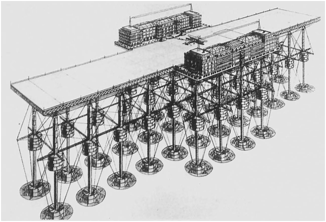
Engineer Edward R. Armstrong’s (1876–1955) seadrome project arose when the Western “lack of islands” concept met aviation technology’s refueling challenges. It failed because of an airplane’s horizontal orientation for takeoff from and landing on artificial islands. Before developing his proposal, Armstrong migrated from Canada to the United States, gaining experience in oil drilling and aviation, and served as a naval officer during World War I before working for the chemical company Dupont. After years of contemplation and testing very small models, Armstrong unveiled his seadrome concept in a 1923 aviation journal, having filed patents in 1919 and 1922. The concept initially had little impact.Footnote 22 In 1926, he founded a company and, in the following year, proposed a chain of eight redesigned seadromes spaced about 483 kilometers (300 miles) apart across the Atlantic at the latitude of the Azores. Later proposals also addressed the Pacific Ocean, which Terada Torahiko read about, aiming to connect Hong Kong and Canada. However, Armstrong’s primary focus remained the North Atlantic. The installation of radio beacons and new radiophone technology, discussed in Chapter 5, was intended to help airplanes locate seadromes even in adverse North Atlantic weather. Armstrong’s economic evaluations, more advertisements than realistic forecasts, had their costs more than quadrupled over a decade marked by deflation, indicating that investors had little trust in his analysis. Initially, in 1927, he estimated costs at around US$25 million, with annual operation costs of US$9.1 million, offset by an optimistic annual income of US$50 million from one million passengers. A gigantic, dubious number that shifted most of the annual ocean liner passengers of all classes to airplanes. The estimated volumes and weight of passengers and mail minimized airplane tank space, demanding refueling at each platform, which is where the main problem began. Regular horizontal airplane takeoffs and landings required adaptation to marine conditions, including all weather conditions and wave intensities. This necessitated a long, flat deck as a runway (366 m x 61–122 m), achievable only through a floating platform design (see Figure 3.1). Ship designs, including aircraft carriers, could not provide this degree of stability due to wave impact.Footnote 23 The first operational US aircraft carriers (Lexington Class) were built between 1920 and 1927, but they were unsuitable for large, passenger-carrying civilian aircraft due to the perilous nature of landing maneuvers, which has not changed to this day. Armstrong’s adaptation to marine condition meant that, in contrast to an aircraft carrier hull hit by waves, seadromes featured individual submerged legs with buoyancy chambers and ballast tanks, reducing wave impact and enhancing stability by letting water pass between them (see Figure 3.1). Each seadrome was to be connected on one side to a floating anchor structure moored to the seabed, intended to minimize movement but another source of problems. The platform deck, hosting the floating runway and adjacent building complexes like a hotel and radio facilities, was elevated well above the sea surface to prevent wave interference.Footnote 24
A seadrome as envisioned by Armstrong circa 1927, depicted out of water.
The seadrome proposal received huge public interest, demonstrating the influence of Western “islomania” and the new “lack of islands” notion in the Atlantic. Armstrong unveiled his redesigned seadrome proposal in May 1927, spurred by aviation pioneer Charles A. Lindbergh’s (1902–1974) pioneering nonstop transatlantic flight. The event undoubtedly fueled Armstrong’s motivation to leverage the media attention surrounding Lindbergh to promote his own transatlantic aviation proposal.Footnote 25 Over the next two years, interest in his idea surged. By the autumn of 1929, he was testing a 1:32-scale model, backed by investors.Footnote 26 However, the Wall Street Crash in October 1929, marking the onset of the Great Depression, made investment funds scarce. Simultaneously, there was a transatlantic, and even global, media discussion around seadromes as artificial island solutions to the absence of a natural island chain across the North Atlantic. Newspapers in Japan, British India, and South Africa, among others, reported on the seadrome proposal, but the epicenter of the discussion was in North America and Western Europe. US newspapers and pulp fiction magazines linked seadromes to the Atlantis myth, Utopia, and portrayed them as a novel oceanic “frontier,” characterized by tales reminiscent of Old West–style mail coach robberies and kidnapping, which all reflected the commercialization of the “islomania” cultural heritage. Female authors indicate that, although all inventors in this chapter were male, women were affected by Western “islomania” and interested in inventions supposed to enable an industrial-strength transformation of the oceanic environment.Footnote 27 Journalists and writers used “floating island” and “artificial island” interchangeably with “seadrome,” showing the contemporary perception of these largely stationary structures as distinct from constantly moving vessels but ready to be integrated into “islomania” ideas. The media’s dual fascination with “islomania” and aviation technology, dating back to the Wright brothers’ 1903 Kitty Hawk flight, heightened the attention. Armstrong’s proposal, blending the first design iteration of ocean platform style with manifestations of modern aviation, fostered a new spatial imagination integrating both sea surfaces and airspace into an artificial island chain extending the human habitat far beyond two continents. Armstrong further linked “islomania” to aviation by naming his seadromes after aviation pioneers, thereby presenting them as heroes of industrial modernity whose feats now merged with the island-building task once the realm of ancient deities or the Christian God. Nevertheless, investors primarily focused on the engineering, economic, and military aspects of the proposal, explaining why extensive media coverage did not lead to any actual seadrome construction.
Previous research on the failure of the seadrome proposal primarily examined events in the United States and airplane technology changes, neglecting the ocean’s material conditions. They concluded that very unfortunate timing, compounded by advances in airplane range making seadromes obsolete, doomed the project.Footnote 28 Fast-forward to the early 1930s: President Franklin D. Roosevelt’s administration, assuming office in early 1933, initially showed interest in the proposal as part of the New Deal, after a meeting between Armstrong and the president. In the autumn of 1933, Armstrong’s company sought a US$30 million loan from the Public Works Administration, but no funding was forthcoming. Prominent figures such as Charles Lindbergh, initially a supporter of Armstrong’s proposal, and airplane designer Igor Sikorsky (1889–1972) advised federal authorities against it in November 1934, anticipating larger airplanes capable of transatlantic flights without refueling stops. Previous studies regarded this negative feedback as central, which they associated with Lindbergh’s new advisory role at Pan-American Airways, a company using Sikorsky’s flying boats (or seaplanes) not requiring seadromes or other dry runways.Footnote 29 The timeline for these expected airplane technology advances remained a topic of debate, however. Figures like aviator Louis Blériot (1872–1936), the first to fly across the English Channel in 1909, still supported the seadrome proposal in 1935, equating its importance with the opening of the Suez and Panama canals.Footnote 30 Despite the rise and demise of zeppelins as a limited-capacity alternative for transatlantic travel, airplanes ultimately prevailed, as demonstrated by Pan-American Airway’s first passenger flight across the North Atlantic in June 1939 using a Boeing 314 flying boat, albeit with a very small passenger volume. It confirmed Lindbergh’s view but was far, far below the seadrome proposal’s intended capacity.Footnote 31
Previous studies also stated that the Roosevelt administration’s concerns about the legal status of seadromes in international law was a factor in the proposal’s failure.Footnote 32 In October 1930, the International Aviation Legal Committee (Comité juridique international de l’aviation), the international governing body for aviation law, debated its legal status extensively. Comité members did not recognize seadromes as equivalent to naturally formed islands or ships, necessitating a new legal framework.Footnote 33 Aware that their decisions had to be recognized by their governments, the members voted that seadromes could only operate under state authority and responsibility. They proposed that location disputes, such as placing a seadrome near another country’s ports or airports, should be submitted to the League of Nations or international arbitration, given that the territorial sea and therefore state control were limited to three nautical miles (5.56 kilometers).Footnote 34 These legal considerations aimed to apply the concept of territoriality to artificial islands in international waters, akin to how a ship’s space constitutes a very small pocket of national territory. None of these legal decisions prevented the construction of a seadrome.
Armstrong’s libertarian “islomania” was more controversial from a state’s perspective, especially during the US Prohibition era (1920–1933). He envisioned using the seadromes’ undefined legal status to establish multiple legal layers, not much different from modern shipping practices. In May 1931, he envisioned seadromes with an owner-crafted legal system, including allowance for alcohol and gambling tourism. This vision, leveraging international waters, distilled centuries of Western philosophical and science fiction literature about imaginary island societies that, secluded from the rest of the world like in Utopia, had created their own inspirational legal regimes, into establishing what today could be called special economic zones. Historically, casino and gambling ships in international waters, connected to ports by ferries, were a source of annoyance to state officials, yet Armstrong’s vision turned such ideas into part of a promise (is)land. However, beyond these libertarian ideas, it is important to recognize that the monotony of contemporary flights made getting drunk a popular remedy for this problem. Armstrong, while ruling out other practices illegal in the United States, explained that the seadrome would be property of US citizens, and the US government had the obligation to protect such property, despite him planning to register it under a different flag, foreshadowing the later “flags of convenience” trend in shipping.Footnote 35 Further iterations of this libertarian “islomania” will continue to surface in later chapters. Nonetheless, some level of compromise was always achievable, indicating that legal issues never outright obstructed seadrome construction.
I find the seadrome proposal’s failure to be the result of its inability to adapt to oceanic material conditions, both vertically and horizontally. Archival materials from the United Kingdom emphasize concerns about the seadromes themselves, which mattered far more. As the leading sea power and the world’s largest empire, British government officials were acutely aware of maritime and aviation issues. Armstrong’s proposal was notable for multiple reasons. He intended to locate the first seadrome off the North American continent, establishing a passenger airplane route to British-colonized Bermuda. Although Bermuda was too far south for the planned transatlantic seadrome route, this shorter secondary route aimed to boost airplane tourism to Bermuda, thereby attracting investment capital for the first floating airport. British documents, dated January 1931, confirm that the Great Depression hindered investments from private companies or governments.Footnote 36 However, in a November 1934 meeting, high-ranking British officials expressed reluctance to support the seadrome proposal, underlining key problems emerging from failed adaptation to oceanic conditions. Armstrong’s seadrome design was judged to be functional in shallow waters but not further offshore, which horizontally limited the marine regions in which it could be used. Air Marshal Hugh Dowding (1882–1970) and others pointed out the feasibility of the project in shallow waters, but the difficulties of anchoring a seadrome in deep ocean waters highlighted the vertical challenge of depth. According to them, Armstrong’s idea of connecting the seadrome at one end to a floating anchorage system moored to the seabed, supposed to align the seadrome with the wind for safe airplane landing, was not feasible. The second problem concerned the horizontal takeoff and landing of airplanes. The construction of a long, elevated horizontal runway was highly problematic for military use. While one official agreed with Armstrong that a seadrome would be very difficult to sink due to its many individual buoyancy legs, its potential military use made it an immediate target in case of a conflict. The problem was that any enemy vessel shelling the long, horizontal runway disabled its use for aircraft operations without any need for sinking the floating airport.Footnote 37 The seadrome being very immobile but having to return to port for repairs meant that aircraft carriers would be much more efficient. About two months later, discussions between the British air attaché and US colleagues in Washington, DC, revealed similar concerns from US military officials.Footnote 38 These noteworthy mooring challenges in deep waters and seadrome runways becoming priority targets for easy disablement in a military conflict further discouraged government investors from funding such costly structures.
The seadrome proposal’s failure, due to insufficient adaptation to marine conditions, however, did not mark the formal end of seadrome “islomania.” In early 1939, engineer Frederick G. Creed, unrelated to Armstrong, attempted to present alternative seadrome designs to the British military officials, who again viewed them as huge liabilities in conflicts.Footnote 39 In May 1942, during World War II, Armstrong modified his design, addressing the two issues through a focus on downward verticality. He proposed a new mooring system with vertical cables extending from the platform legs to seabed ballast tanks. Additionally, in emergency cases, an oil derrick–like “haul down mechanism” used these cables to pull the seadrome deck, including the runway, several meters below the sea surface to protect it from shelling and bombardment. Armstrong applied his terrestrial oil drilling expertise to use a marine region’s downward-oriented dimension to mitigate military vulnerabilities of a long horizontal runway.Footnote 40 Nonetheless, such a seadrome, reminiscent of tension-leg oil platforms constructed decades later, was never built. For full submergence, the runway had to be clear of airplanes, making it infeasible. However, the concept started the trajectory leading to vertically oriented platforms.
The Rise of Upward Verticality in the Oceanic Anthropocene
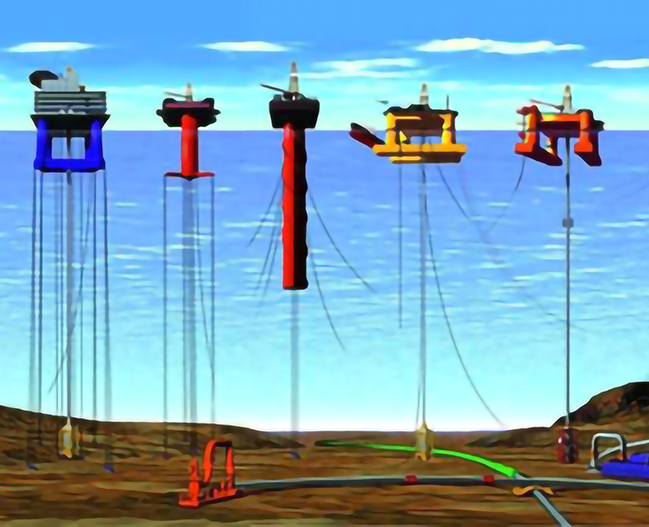
The seadrome proposal’s failure was important in shaping the oceanic Anthropocene. Already in 1938, Armstrong repurposed his floating platform design for a new task: offshore oil drilling, a defining characteristic of the oceanic Anthropocene. As the previous chapter showed, offshore oil exploration in that year entered the bays of the Gulf of Mexico. Armstrong made important design contributions to several offshore platform types, which after World War II illustrated the extension of the Age of Coal’s energy-intensive, steel-made built environments to sea surfaces, initiating the oceanic Age of Oil. Before exploring the upward orientation in ocean platform style, it is worth showing very briefly how Armstrong’s designs contributed to the early construction of offshore platforms, since they emphasize the adaptation lessons learned for shallow but turbulent waters. Armstrong’s initial seadrome design was a semi-submersible, meaning tugboats would move it, and stabilization at the operation site would happen by partially submerging it, using the ballast chambers (see Figure 3.2). In the 1930s, Armstrong started working for Sun Oil, one of the successors to John D. Rockefeller’s Standard Oil Co., possibly through their subsidiary Sun Shipbuilding Co., which had built Armstrong’s 1:32-scale model in 1929. From the late 1930s until his death in 1955, he adapted his seadrome design, filing several platform patents, some assigned directly to Sun Oil. His first patent, filed in 1938, described a design capable of operating in open waters, unlike the submersible drilling barges used in Louisiana’s bayous and Lake Maracaibo’s calm waters, discussed in the previous chapter. The Gulf of Mexico’s nearshore waters, shallow but hurricane-prone and turbulent, would cause no functionality problem, as the British officials had noted. Armstrong’s oil platform, designed as a large submersible, operated vertically by resting on the seabed when its leg ballast chambers were flooded, keeping the deck and drilling equipment above the water level. He republished this design in early 1947, amid burgeoning exploration in the Gulf of Mexico and discussions in oil journals about the required, new types of drilling platforms for open waters, including his design.Footnote 41 Two years later, in 1949, a different designer launched the first mobile, submersible platform, followed by a larger design finished in 1954, both of which inevitably must have taken inspiration from Armstrong’s designs.Footnote 42 Other patents for offshore drilling platforms, filed in 1948 and 1950 for use by Bethlehem Steel and Erle P. Halliburton, referenced Armstrong’s patent, illustrating his inspirational influence in the early development of US offshore oil drilling.Footnote 43
The two platforms on the left are tension leg platforms, stabilized by vertically tensioned mooring cables that prevent upward movement. The two platforms on the right are semi-submersibles, characterized by sufficient buoyancy for floating yet stabilized in shallow waters by adding ballast water, enabling partial submersion. The central platform is a spar platform, its stability derived from the design’s deep draft displacing water. The image illustrates platform types and mooring systems, yet the water depth associated with each platform type varies strongly in reality.
Armstrong also made contributions to other offshore platform types and their methods of anchoring in turbulent waters. In 1944, amid the resurgence of offshore oil exploration following the diminished threat of German submarines, Armstrong filed a patent combining two mooring systems. This submersible platform could rest on the seafloor in shallow waters and employed his World War II concept from two years prior for deeper waters. Anchor cables extended from the platform’s legs to weight anchors on the seabed. When the buoyancy chambers were flooded, partially submerging the platform, the anchor cables were locked in. Afterwards, the chambers were emptied again to “tension the anchor cables,”Footnote 44 stabilizing the platform against rising and other movements. Decades later, this mechanism would be used for tension-leg platforms (see Figure 3.2), a type of floating offshore installation used for oil and gas development in deep waters. In a patent assigned to Sun Oil, filed in 1954, Armstrong also introduced a jacking system for submersible platforms. Once the lower platform part was submerged with its legs standing on the seabed, this system could jack them up to elevate the deck above the surface (see Figure 2.3 in the previous chapter for a jack-up rig).Footnote 45 While not the first to use a jacking mechanism, Armstrong’s design contributed to the early days of jack-up rig designing. In the same year, 1954, The Offshore Company (now Transocean Co.) launched the first fully mobile jack-up rig “Rig 51,” and engineer Robert G. LeTourneau (1888–1969) began work on the very different but successful “Scorpion” for Zapata Off-Shore Co., founded by future US president George H. W. Bush.Footnote 46 This was soon followed by the Dai-1 Hakuryū jack-up rig design introduced in the previous chapter.
It seems none of Armstrong’s oil platform designs was built either. They aligned more with his original seadrome concept and did not meet the specific needs of offshore drilling at the time. In his ocean platform style designs, form did not follow function, and many features were not used in platform construction until decades later, being unnecessary for the shallow waters of the 1940s and 1950s. Regarding his other designs, the early submersibles and jack-up rigs emerged amid strong investor fears of bankruptcy if their costly investments, after launch, failed to adapt to rough waters, strong winds, and seasonal weather phenomena like hurricanes. With platform construction knowledge still in its infancy, few proposals received funding. Yet Armstrong’s proposals, news items, and patents illustrate his inspirational role in the development of submersibles, jack-up rigs, semi-submersibles, and tension-leg platforms. By the 1960s, some oil company staff still colloquially referred to submersible designs as “seadromes.”Footnote 47
The key point is that in the 1940s and 1950s, the engineering solution to the “lack of islands” was found. The seadrome proposal created the concept of realizable artificial islands in people’s minds, combining large quantities of coal-made steel for their construction with the petroleum-based fuel demands of airplanes. Oil platforms materialized these imaginary islands in reality and anchored them more firmly in the Anthropocene, marked by rising oil demand and consumption that shifted energy-intensive built environments to sea surfaces and reoriented them upward.
The transition from horizontally oriented seadromes to vertically oriented oil platforms addressed the challenge of accessing platform decks, elevated meters or tens of meters above the sea surface for safety reasons. This distance between a vessel on the sea surface and a platform deck far above physically confronted arriving or departing crews with verticality. The oceanic-vertical perspective helps understand the trajectory of ocean platform style’s adaptation to the oceanic environment, leading to the creation of an archipelago of offshore oil platforms equipped with vertically oriented helipads, and eventually to offshore rocket launch platforms, serving as embryotic spaceports or vertical gateways to outer space. Unlike imaginary seadromes designed for horizontal aircraft access, the transition to oil platforms made airplane access impractical due to the absence of a horizontal runway. Flying boats also faced the vertical dilemma by using the sea surface as a runway, but after landing they looked at a platform deck elevated high above them. Ships, boats, and tankers maintained horizontal connectivity for transporting supplies and oil, but vertical access became critical for crew safety. A confrontation with verticality could be lethal. In the 1950s, crew transfers from boats, rising and falling with the waves, to a platform deck involved dangerous methods like climbing ropes or Jacob’s ladders, or being pulled up in cargo nets, especially perilous during storms and strong wave action in the open waters of the Gulf of Mexico. Falling or getting smashed against the platform wall were two of several ways to get hurt or perish. The advent of helicopters, with their vertical takeoff and landing capabilities, revolutionized access and drastically reduced the risk of accidents.Footnote 48 Helicopters had been developed specifically for use at sites where horizontal space was limited or infrastructure was lacking. Advanced during World War II toward mass production, helicopter technology after the war became more economically accessible for civilian use. In 1947, Shell Oil Co. trialed helicopter use for surveying in Louisiana’s bayous, where vegetation cover discouraged conventional airplane and waterplane operations. In 1948, the first helicopter landed on a platform about 30 kilometers into the Gulf of Mexico, heralding the new upward-oriented spatiality in the oceanic Anthropocene. By the 1950s, helicopter use became more frequent for safe transport between artificial islands and land.Footnote 49 Despite not altering cartographic representations of seemingly flat marine regions, helicopter use changed how crews conceptualized the human habitat, turning platform decks into distinct destinations and departure points in three-dimensional marine space. From the mid-twentieth century onward, this vertical access has characterized the “islomania” of creating artificial islands. For many of the approximately 101,000 workers (as of late 2010s) in offshore industries worldwide (thus excluding shipping), confrontations with verticality at sea were key physical experiences of work and safety.Footnote 50
The vertical orientation emphasizes that offshore platforms are not isolated and unconnected sites for capitalist corporations (and previously also communist enterprises) to act without restraint. Anthropologist Hannah Appel’s study on Equatorial Guinea, while insightful, may have unintentionally conveyed this misconception due to the problematic terra-centric view prevalent in academic literature, which regards the ocean as a barrier. This “ocean-as-separator” narrative, similar to “oceans connect and divide” stories, portrays offshore platforms as isolated, remote, and inaccessible because of their distance from landmasses. Physical distance, however, is only very vaguely related to accessibility and speed between locations in transportation space. Appel’s quotes from interviews with Western oil personnel, if taken at face value, suggested that offshore locations enhance security in hazardous areas like Equatorial Guinea and minimize workflow disruptions. However, the oil personnel’s security assertions, rooted in the “ocean-as-separator” narrative, likely aimed to advertise their industry as safer than land-based operations by conforming to terra-centric social expectations among listeners or readers rather than accurately depict the situation, omitting the reliance on helicopters and land-based heliports. Without question, theft of oil is more difficult. But any deliberate disruption of the helicopter infrastructures would impede the platform’s operations, as crews would not simply change to using boats due to the elevated platform decks. Any attacks on terrestrial heliports would pose noteworthy security threats to crews, highlighting that the ocean does not create the alleged separation or isolation. Other quotes in the same section in Appel’s book, from Equatorial Guinean government officials and oil personnel, imply that offshore platforms are less accessible to environmentalists or government inspectors for monitoring pollution or working conditions. This once again unchallenged “ocean-as-separator” bias caters to terra-centric social expectations instead of a realistic assessment of political, legal, and material conditions. First, terrestrial locations are not inherently more accessible than sea locations; second, legal frameworks under the Law of the Sea and domestic laws ensure that government officials can inspect platforms, possibly accompanied by environmentalists as advisors, contradicting monocausal narratives of the “ocean-as-separator” being the reason for an exploitation of offshore sites by global capitalism. For decades, helicopters have facilitated access to offshore platforms not only for crews but also for government officials and even academics. Today, crane-like gangways on boats do the same. The lack of government oversight of capitalist practices – or even those of national oil companies – more likely stems from government officials’ terra-centric indifference to offshore activities and their kleptocratic ideas of the role of the state or regulatory capture, rather than an imaginary oceanic separation. One receives the impression that Equatorial Guinean government and oil personnel’s narratives of such separation facilitating capitalist misconduct are excuses for weak and bad governance structures failing to regulate capitalist or any other corporations, a situation related to Equatorial Guinea being ruled by a paranoid and arbitrarily violent dictatorship, as Appel notes elsewhere and as other studies also emphasize.Footnote 51
The pivotal role of verticality in creating air transport corridors to artificial islands is further highlighted by the absence of floating seadromes to date. Armstrong’s seadrome proposal saw a brief resurgence during the 1960s and 1970s with the emergence of jumbo jets requiring longer runways. This revival was driven not by airplane range limitations but by the scarcity of horizontal space, particularly in cities where urban development, noise complaints around airports, and opposition to land expropriation hindered airport expansion. These terrestrial spatial constraints fueled ideas for floating platform airports in the urban waters of densely populated areas such as New York City and Japan.Footnote 52 US Navy research into floating platforms as military bases in the early 1970s, discussed further in Chapter 7, inspired ultimately fruitless considerations of such platforms for civilian purposes like floating airports.Footnote 53 In Japan, geographic constraints led to novel proposals for expanding urbanization onto sea surfaces as early as the late 1950s, as the following chapter will illustrate. The most serious contemplations for creating artificial airport islands, either through floating platforms or, alternatively, reclaiming islands through offshore landfill, occurred there. In the 1960s, the Japanese government decided on the construction of a new airport for the capital city. Narita International Airport was built between 1967 and 1978 in nearby Chiba Prefecture. Plagued by decades-long violent protests against land expropriation, authorities decided against a repetition of this approach elsewhere.Footnote 54 In the 1970s, for the Kansai (Osaka-Kobe) region’s new airport, government officials considered placement in Osaka Bay. Japanese newspapers elaborated the methods to create new horizontal space, among them large floating platforms, elevated platforms on piles, or new islands through landfill.Footnote 55 From the late 1950s, Japanese star architect Kiyonori Kikutake (1928–2011) had made visionary, technically unfeasible proposals for moving the urban industrial built environment onto sea surfaces, as the next chapter shows. By the early 1970s, prioritizing feasibility, he repeatedly advocated for offshore airports, although not necessarily in floating form. I fully agree with historian Imamura Sōhei that Kikutake’s ideas were very important in prompting journalists and government officials to consider airports off existing land. Another reason was the ongoing public and academic discussions in the United States and other countries about such types of airports. In the mid-1980s, Kikutake introduced a design for an offshore airport, elevated on a stilted platform.Footnote 56 Nevertheless, Japanese authorities eventually chose offshore landfill for Kansai International Airport, dismissing large platforms, whether stilted or floating. After the first terminal and runway were built between 1987 and 1994, the airport’s sinking issues due to subsidence and soft seabed materials exemplified the challenges of such projects. Engineering decisions and marine conditions made the airport sink much faster than expected.Footnote 57 These problems led to another rise and subsequent demise of the seadrome concept. The Japanese government initiated the Megafloat (megafurōto) project in Tokyo Bay between 1995 and 2001, testing the feasibility and safety of a floating runway under the bay’s marine conditions such as wave impacts in 30-meter-deep waters and potential airplane crashes and earthquakes. Yet for Kansai International Airport’s second runway, built again through offshore landfill between 1999 and 2007 using 250 million cubic meters of soil, as well as for subsequent airports, Japanese authorities continued to avoid floating or seabed-fixed platforms, instead applying lessons from the first offshore landfill island.Footnote 58 The seadrome proposal, therefore, inspired a new and very rare form of land reclamation, combining ideas of landfill that normally served to extend coastlines with that of creating artificial islands to interact with other spatial layers, though this merger of ideas changed from Armstrong’s goal of connecting continents to gaining large horizontal construction spaces near urban settings. This specific technological branch, creating an alternative to the more influential trajectory of building vertically oriented artificial islands connecting sea surfaces to airspace and outer space, remained aligned with a horizontally oriented, terra-centric strategy of completely transforming aquatic spaces into land. The physical transformation was a major difference compared to use of floating or elevated artificial islands. The environmental consequences of Japanese land reclamation are addressed in more detail in Chapter 8.
The non-implementation of floating airports resulted from various factors, including local oceanic material conditions and, in some cases, environmental concerns. These environmental concerns, particularly pollution concerns in the United States, are briefly addressed in Chapter 6. However, globally, the prohibitive cost of large horizontal floating platforms was a key obstacle compared with vertically oriented ones, as noted by one of Kikutake’s collaborators in the mid-1970s.Footnote 59 The increasing size of airplanes and the corresponding need for longer runways further disincentivized such floating projects, despite the engineering challenges associated with creating artificial islands through offshore landfill, as seen multiple times in Japan. Regardless of these ongoing problems with horizontal airplane runways off the coast, vertical takeoff and landing remained the dominant adaptation approach of the built environment to oceanic conditions. It had a defining impact on the spatiality and onset of the oceanic Anthropocene.
Offshore Launches and Earth Orbits in Vertical Space
The vertical dimension of artificial islands has created multiple connections to outer space. Once again, petroleum-derived fuels have played a very important role in establishing this vertical link, bridging the offshore built environment with the scientific and economic opportunities of utilizing near-Earth space. The twentieth and twenty-first centuries witnessed fluctuating interest in outer space, including human expeditions to another celestial body. For a short moment, considering a future “solar-system system,” as historian Ben Finney termed it – a concept where multiple celestial bodies in the solar system serve as human habitats connected to each other – one becomes even more aware of the role of verticality.Footnote 60 Unlike a terra-centric, horizontal perspective, this post-Earth vision of human habitation is dominated by extreme verticality. It provincializes Earth from the cradle of humanity into just one of many solar system destinations, all reached through voluminous transportation spaces extending upward from celestial bodies’ surfaces. Now leaving this futuristic scenario again, vertical access to near-Earth space through crewless rockets has gained immense importance for both Earth’s terrestrial and aquatic surfaces. Since the 1960s and 1970s, satellites placed in Earth orbits have revolutionized navigation, with systems like the global positioning system (GPS) and its predecessors, and communication, through satellite data transfers, satellite telephony, and satellite internet. The transportation of satellites into orbit, landings of objects returning from space, and potential missile launches from military submarines with the intention of them, on their return to Earth’s surface, causing nuclear explosions in enemy territory became intricately connected to the ocean. In other words, since the early Space Age, various rockets have been launched from ships and offshore platforms, astronauts’ capsules have returned to sea, and military submarines were ready to cause the end of the world as we know it. Recently, space companies like SpaceX and Blue Origin have pioneered the recovery and reuse of rocket boosters. Multi-stage rockets usually use different fuel mixes in several booster stages, adjusted to the changing material conditions encountered during their flights. Since April 2016, such recovery integrated offshore landing platforms and ships into the vertically oriented transport infrastructure to the atmosphere and outer space.Footnote 61 The following examples of offshore rocket launch platform development illustrate the next step in the trajectory of upward-oriented artificial islands, succeeding the construction of helipad-hosting oil platforms.
The location of a launch site greatly affects the rocket’s payload capacity and the frequency of reaching orbital destinations such as space stations. Earth’s (eastward) rotation is fastest at the equator, providing an additional boost for eastward launches compared to sites further north or south, aiding rockets and their payloads in escaping Earth’s gravity. In other words, launching from an equatorial site into an easterly direction is the most efficient way of placing a satellite in an equatorial Earth orbit. Low Earth orbits, below 2,000 kilometers, allow satellites on equatorial orbits to rotate around Earth above the equator. Higher, geostationary orbits, at about 35,800 kilometers, synchronize satellite rotation around Earth with Earth’s rotation, appearing stationary above a specific equatorial point. Yet not all satellites benefit from equatorial launches. For example, satellites on polar orbits, rotating around Earth on a north–south axis, gain little from an equatorial launch site and a launch into an easterly direction, albeit also not losing anything from such a location. However, if the aim is to reach an equatorial Earth orbit, equatorial launch sites offer a second benefit by avoiding the need for additional maneuvers. Launch sites at higher or lower latitudes, like Florida’s Kennedy Space Center, require extra fuel for an inclination change to the south or north, resulting in a reduced payload capacity. Equatorial launches also allow more frequent access to structures like space stations in equatorial low Earth orbits, appearing overhead approximately every 90–120 minutes. In contrast, the International Space Station (ISS), whose orbit was chosen to make it pass both Russian and US spaceports in the northern hemisphere, is reachable only about once per one to three days. Consequently, the rise in verticality since the beginning of the Space Age in the late 1950s, due to Earth’s material conditions, increased the significance of equatorial terrestrial and oceanic space as launch sites.
In 1961, during the US governmental ambition to surpass the Soviet Union in the Space Race, National Aeronautics and Space Administration (NASA) officials considered establishing mobile offshore launch sites near the equator. Initially proposed in 1958 and reproposed in 1960 to relocate noise pollution offshore, the idea soon afterward gained traction for its equatorial launch advantages.Footnote 62 At a US House of Representatives hearing in May 1961, Samuel Snyder, NASA’s Assistant Director for Launch Operations, emphasized the fuel efficiencies. He stated that launches into equatorial low Earth orbit from Florida required so much fuel for a fast turn that rocket payloads, such as satellites, were reduced by about 80 percent. At a much higher geostationary orbit, requiring less fast turning, the loss was still about 20 percent.Footnote 63 Vice Admiral John T. Hayward (1908–1999), Deputy Chief of Naval Operation (Development), discussed the Soviet Union’s offshore launches from ships in the Caspian Sea and underlined the flexibility and capital efficiency of mobile structures over fixed ones. He proposed using an advanced jack-up rig design, superior to the US military’s Texas Towers, a group of offshore platforms built in the second half of the 1950s to extend the radar range against enemy attacks. One of the Texas Towers had collapsed in January 1961, several months before the hearing took place, killing all twenty-eight crew members. According to Hayward, a more advanced, mobile launch site could be towed to an equatorial island’s sheltered waters, then use its jack-up mechanism to elevate the launch deck above the unstable sea surface for safer launches.Footnote 64 However, the decision after the hearing reflected a terra-centric financial lock-in that has continued until today. Investments into the terrestrial launch sites at the US east and west coasts were deemed so high that they discouraged investment in a new offshore launch infrastructure.Footnote 65
The sustained fixation of capital over the next six decades further reinforced the lock-in effect but conflicted with advances in rocket technology. The cost–benefit analyses of the 1960s had genuinely different variables compared to those of today, largely due to these advances. During that time, rocket launches were infrequent, and the entire rocket was lost after delivering its payload to orbit. Fuel considerations were just one of many economic concerns. Additionally, economic factors often took a backseat to military interests and national security, which included maintaining launch facilities within the continental United States. In the 2010s and 2020s, however, developments such as the reusability of rocket boosters led to a dramatic reduction in launch costs and a strong increase in the frequency of launches. These advancements illustrate the economic shortcomings of NASA’s existing launch infrastructure, maintained in place by the gigantic capital investments fixed in them. The impact of reusability is exemplified by the average cost of US space shuttle launches from 1981 to 2011, which was US$65,400 per kilogram of payload (adjusted for official inflation until 2021) for transport into low Earth orbit. In contrast, SpaceX managed to reduce the cost of its Falcon 9 rocket (used since 2010) to US$2,600 per kilogram, and for its Falcon Heavy (used since 2018) to US$1,500 per kilogram (both also in 2021). While fewer than 1,000 operational satellites orbited Earth in 2010, by August 2025 this number had risen to about 12,500.Footnote 66 Satellite services, especially in communication and navigation, have become foundational in many non-space industries, as I discuss in Chapter 5. In essence, the commercialization of orbital space led to space companies, much more so than national space agencies that paved their way, focusing on reducing launch costs. This focus included selecting launch and landing sites as well as constructing corresponding vertically oriented structures, such as offshore platforms and ships. The decreased frequency of accidents also diminished the importance of another original factor in choosing launch sites: avoiding locations with populated areas in the rocket’s trajectory, usually eastward or northward. The following two examples in East Africa and Oceania address the origins of equatorial offshore launches.
The early 1960s saw NASA officials recognizing the benefits of equatorial launch sites, leading to a collaboration with Sapienza University of Rome. For the reasons explained in the 1961 hearing, NASA supported the construction of the San Marco Equatorial Mobile Range, part of which now forms the Luigi Broglio Space Center. Located near newly independent Kenya’s Ungwana Bay in the Indian Ocean, close to the equator, the choice of a jack-up rig design for the platform was influenced, as stated in a NASA report, by its proven effectiveness in the offshore oil industry and its suitability for the oceanic conditions off Kenya. The Italian university and NASA used a refurbished jack-up rig as the control center platform, “Santa Rita,” and after a few uses of a support ship were able to procure a US Army self-elevating (jack-up) barge as the new launch platform, “San Marco.” The Range operated from 1964 to 1988, with its initial launches focusing on sounding rockets until its first cargo-bearing rocket launch in 1967 placed a satellite into equatorial orbit.Footnote 67
The “Santa Rita” and “San Marco” platforms represented the very early extension of the Space Age’s vertically oriented built environment onto sea surfaces. Site selection was influenced by the desire to utilize Earth’s eastward rotation for the additional boost and to ensure that, in the event of an accident, debris would fall over open waters rather than inhabited areas. Given the concentration of Earth’s landmass in the northern hemisphere and its relative scarcity near the equator, viable launch sites on or near land with open water to the east were limited to eastern South America, East Africa, and Southeast Asia. The San Marco Range slightly preceded another near-equatorial launch site, the Guiana Space Center in French-colonized French Guiana in eastern South America, which began land-based launches in 1968 due to its favorable location bordering the Atlantic Ocean.
The growing importance of verticality in the early Space Age was also emphasized by the negotiations leading to the Outer Space Treaty of 1967. This treaty categorized outer space as a new domain in international law, showing its increased accessibility through rockets and more frequent use for satellite placement. The intensifying sea surface–outer space connections, exemplified by the launch platforms, contributed to a conceptual shift in how people involved perceived their position on Earth. The waters off Kenya, for example, underwent a transformation, becoming a vertical gateway to the atmosphere and outer space, creating a spatiality rooted in the oceanic Anthropocene’s energy-intensive marine built environments and the petroleum-derived, highly refined kerosene powering rockets’ first booster stages.
The offshore location of the launch site in international waters meant that operators did not need to acquire land but rather had some distance from it, avoiding potential conflicts with locals over expected noise pollution and a corresponding unwillingness to support the project. Gaining distance from inhabited areas inevitably meant going beyond the territorial sea of 3 nautical miles (5.56 kilometers). Thus, only the support facilities were land based. Being in international waters also provided the benefit of launches not being directly subject to Kenyan legislation. However, the Kenyan government could have exerted judicial and other pressure on the land-based facilities if needed, reminiscent of the dependence of oil platforms on terrestrial helicopter airports.Footnote 68 The platforms’ mobility meant they could be relocated in the event of political issues, but the very limited number of alternative locations fostered collaboration with the Kenyan government.
The Kenyan government’s participation in the “Bogotá Declaration” of 1976 alongside seven other equatorial states was undoubtedly influenced by the equatorial offshore launches. This declaration proclaimed sovereignty over the geostationary orbit above these states’ equatorial territories, where satellites remained stationary relative to the Earth’s surface. The eight governments considered the geostationary orbit valuable and limited, expressing concerns that industrialized countries might fill it before they could deploy their own satellites. In contrast, the geostationary orbit over international waters was proposed as part of the “common heritage of mankind,” a legal principle frequently discussed in Law of the Sea debates since 1958 and typically associated with diplomat Arvid Pardo (1914–1999) and ocean researcher Elisabeth Mann Borgese (1918–2002), pertaining to the seabed beyond territorial waters. This principle, in its earlier form as the “common interest of mankind,” was applied to the Outer Space Treaty of 1967.Footnote 69 Thus, the Bogotá Declaration must be viewed in the context of decolonization and debates about a New International Economic Order, which sought greater economic influence and equality for countries identifying as the “Third World” vis-à-vis industrialized nations. Unsurprisingly, most UN members rejected the declaration’s attempt to turn the vertical connection between Earth’s equatorial surface and the geostationary orbit above it into a spatio-legal regime benefiting only a few equatorial countries. The eight governments’ claim that their declaration regarding the geostationary orbit followed the same “contiguity” logic, here in a vertical dimension, that had driven the annexation of continental shelves, horizontally adjacent to state territories, through the First UN Conference on the Law of the Sea (1958), was not internationally accepted. Yet the declaration led to broad international acceptance that the “Third World” should have equitable access to it.Footnote 70
The second example, Sea Launch Co., demonstrates the fluctuating intensity of the vertical connection between sea surfaces and outer space during the growth and collapse of the dot-com bubble in the 1990s and early 2000s. NASA’s launch infrastructures, sustained by decades of investments yet economically inefficient for equatorial orbit launches, became the catalyst for Sea Launch’s commercial rocket launches from a mobile offshore platform. Founded in 1995 following the Cold War’s conclusion and the early internet’s commercialization, Sea Launch launched satellites between 1999 and 2014. This venture was a collaboration between the US aerospace company Boeing, responsible for launches and interested in providing orbit placement options to its satellite customers, and Norwegian, Ukrainian, and Russian companies supplying the mobile platform, command ship, and rocket parts. The uncertain question of control over Baikonur space port after the breakdown of the Soviet Union, located in Kazakhstan, encouraged Russian participation. To no surprise, the company ceased operations in 2014 amid escalating tensions between Russia and Ukraine over the Crimean Peninsula. Nevertheless, its 2009 bankruptcy illustrated the economic challenges facing new commercial space enterprises, as was also evidenced by SpaceX, founded in 2002, nearly going bankrupt in 2008 due to launch failures. Sea Launch’s inception was fueled by the same excessive optimism regarding the internet’s possibilities that characterized the growth of the dot-com bubble. Satellite internet companies envisioned vast constellations for global internet access, predicting a surge in demand for satellite launches. However, when these companies went bankrupt, Sea Launch’s prospective customer base collapsed, and debt mounted. From 1999 to 2014, it successfully deployed only thirty-two satellites during thirty-six launches, averaging slightly more than two per year, falling short of its license’s expectation of six launches annually.Footnote 71 Despite this, the company played a noteworthy role in developing vertical connections offshore, operating very far off coastlines unlike the San Marco Range.
Sea Launch’s “Odyssey” launch platform sheds more light on the technological trajectory from seadromes to helicopter-using oil platforms to rocket spaceports. This evolution also reflects the human continuum linking what I analyze as the primary, vertically oriented trajectory and the alternative, horizontally oriented trajectory leading to landfill airports. Armstrong’s activities connected seadromes with early oil platforms. NASA and Sapienza University linked oil platforms and launch platforms using jack-up rigs. Sea Launch refurbished a semi-submersible oil platform. An example of human continuity is engineer Nakajima Toshiō (born 1947), who, as a master’s student in the early 1970s, worked with Kikutake Kiyonori in Hawai’i on floating platforms, a topic explored further in Chapter 7. Later, in 1981 and 1982, after returning home to Japan, he conducted stability tests on a semi-submersible oil platform built by Sumitomo Heavy Industries, which Sea Launch later modified and used for its launches, reigniting his interest in new offshore platform spaceports. During that time, in the late 1990s and early 2000s, he worked on the Megafloat runway project in Tokyo Bay, representing an element of the horizontally oriented trajectory leading from Armstrong’s artificial islands to offshore landfill, testing but eventually abandoning floating platforms for airport runways.Footnote 72
Sea Launch utilized this mobile platform for equatorial launches in the Central Pacific. Departing from its home port facilities in Long Beach, Los Angeles, the self-propelled launch platform and accompanying command ship journeyed approximately seven days to a location at 0°N 154°W, roughly 2,000 kilometers south of the Hawaiian Islands and about 425 kilometers southeast of Kiritimati (Christmas Island).Footnote 73 Opting for equatorial offshore launches aimed to gain a cost advantage over the French company Arianespace, the leading commercial launch provider operating from the near-equatorial Kourou spaceport in French Guiana. Sea Launch officials ambitiously claimed they could undercut Arianespace’s price of US$55 million per rocket by US$15 million (leaving out differences in payload capacity). The equatorial offshore launches offered similar launch advantages to those enjoyed by Arianespace and were more cost effective than launches from the Russian cosmodrome Baikonur in the northern hemisphere. Sea Launch’s Zenit 3SL rockets, enhanced versions of Soviet technology designed to offset Baikonur’s disadvantages, had slightly lower launch costs than Arianespace’s Ariane 5G rockets.Footnote 74 Launching beyond EEZs – 370 kilometers (200 nautical miles) was the boundary of Kiribati’s EEZ, where the state had jurisdictional control over pollution and many economic activities – aimed to further cut costs. Some of these assertions were marketing rhetoric, exemplified by a 1997 statement from John McLuckey, president of Boeing’s Information, Space, and Defense Division, who claimed: “By launching from international waters rather than from any one country’s territory, you avoid a lot of problems, including the vast infrastructure – hotels, roads, etc. – that otherwise would be required.”Footnote 75 McLuckey’s statement invoked notions of libertarian “islomania,” suggesting the allure of constructing one’s own artificial island without the expense of costly land-based facilities. However, physical infrastructure obviously was essential. Facilities typically found on land were integrated into the 133 m x 67 m platform, accommodating sixty-eight people. The home port facilities served as a critical infrastructure hub for maintaining and reequipping the platform and command ship, aspects overlooked in McLuckey’s build-your-own-island “islomania” narrative. Total investment exceeded US$1 billion, but with the very important advantage that, unlike NASA’s or Arianespace’s terrestrial investments, much of Sea Launch’s infrastructure was mobile, echoing NASA officials’ early 1960s vision.Footnote 76 McLuckey implied that mobile infrastructures could reduce tax and facility rental fees. However, they obviously incurred alternative expenses, such as maintaining the artificial island – the substitute for land-based facilities. He also indirectly suggested that mobile operations beyond EEZs could circumvent governance issues in equatorial countries, such as corruption or extreme cases of expropriation, as Sea Launch’s mobility allowed operations from the United States and launches beyond the reach of other governments.
Regardless, launching in international waters did not exempt Sea Launch from legal and environmental responsibilities. Its operations invoke memories of the Bogotá Declaration, proclaiming connections between Earth’s surface and outer space, except that in Sea Launch’s case, legal connections extended from the country in which it was registered into formally international waters beyond EEZs and then upward. With its headquarters and home port in the United States, Sea Launch was subject to the Federal Aviation Administration’s regulations, requiring a launch license even for operations beyond the US EEZ. This license mandated environmental impact assessments for the launch site and the vast area potentially affected by the rocket. Sea Launch’s terrestrial facilities therefore extended US legislation to large swathes of voluminous space in the Pacific, covering the waters and airspace that rockets would traverse or potentially crash into. Later sections discuss how this connection to outer space created novel nighttime sea surface transformations, including light pollution. Still, the assessment determined that the environmental impact of infrequent launches was minimal. Multiple stakeholders, including a group of sixteen South Pacific Forum members, expressed interest in the environmental impacts, whose concerns the assessment addressed.Footnote 77 The assessment concluded that with a maximum of eight launches per year (Sea Launch averaged only two), the impacts, such as heat release, were intense yet brief and localized, overall minimal. The ocean ecosystem returned to pre-launch conditions within days. Noise generated by the ship and platform was comparable to 80 km/h winds, a common occurrence in the Central Pacific. The more intense noise during a launch diminished underwater and posed no physical harm to marine life, although it could startle endangered species, warranting further investigation. The likelihood of rocket stages crashing into human structures, marine organisms, or island nature reserves was minimal due to the deep waters (with less oceanic life than shallower, sunlit waters) and the deliberately chosen distance from Pacific Islands and South America. Even in the event of a major accident, such as a rocket explosion on the platform or shortly after takeoff, no lasting environmental damage occurred. No permanent ecological transformations would be caused, allowing marine life like plankton to regenerate over time.Footnote 78 Major launch accidents indeed happened several times.Footnote 79 The assessment also underlined the temporary environmental impacts of mobile launch platforms that were regularly relocated and whose vertical-upward focus extended from the sea surface to outer space – a very notable contrast to the potentially catastrophic environmental effects of oil spills from oil platforms that were a risk of their downward-oriented activities. It is also a contrast to the more unknown impacts of regular ocean dumping of space debris from satellites and space stations.Footnote 80
In May 2023, the American Bureau of Shipping, an NGO specializing in maritime safety classifications, released the world’s first requirements for constructing offshore spaceports.Footnote 81 This initiative was driven by the interest of commerical space companies in constructing and operating such mobile vertical takeoff and landing sites. Mobility allows rocket booster stages, upon landing on a platform or ship, to be returned to their home port for refurbishment, a very cost-saving strategy. Notably, this approach was not applicable to Sea Launch, which ceased operations in 2014, less than two years prior to the first successful offshore retrieval of a rocket booster, a development that substantially contributed to Earth’s amphibious transformation and the artificial island–mediated interactions among sea surfaces, airspace, and outer space.
With the ISS slated for retirement in the late 2020s, NASA and other organizations began funding commercial space station projects and, as NASA termed it, a low Earth orbit economy (LEO) in the early 2020s.Footnote 82 The plans of deploying large satellite constellations for global satellite internet coverage, which originated during the dot-com boom and subsequent crash in the 1990s and early 2000s, came to fruition in the 2020s through SpaceX’s Starlink and smaller companies’ constellations. This resulted in a substantial increase in launch frequency. Altogether, offshore launches and landings, whether equatorial or otherwise, have become part of the strategies of various private space enterprises and governmental space agencies, including those of South Korea, China, and Germany.Footnote 83 Similar to Sea Launch, these offshore operations shift noise, nighttime light pollution, and risks of accidental explosions away from densely populated areas.Footnote 84 However, the growing frequency of larger rocket launches and landings begs the question of their potential impact on the marine environment, resulting in ongoing assessments.
Vertical Perspectives of Earth’s New Light Islands and the Oceanic Anthropocene
The environmental impact assessment of Sea Launch’s offshore launches did not mention light pollution. During nighttime, a rocket launch’s light pollution is short-lived but extremely intense. Daniel T. Dubbs, Sea Launch’s mission director, who had journeyed to the Central Pacific for seven years by 2006, described the experience of a nighttime launch as “the ultimate light show,” where “water lights up for miles around.”Footnote 85 For him, witnessing this sublime technological manifestation of the human capacity to, even briefly, exert such power as to alter the day–night cycle in an environment where darkness typically defines nighttime was both a sensation and entertainment (see Figure 3.3).Footnote 86 The experience, which I term the light island effect, has been observed by numerous spectators and can be conceptualized as a form of high-tech “islomania.” The light island effect visualizes the energy intensity of certain artificial islands, going beyond the usual (non-light) energy intensity related to coal-dependent construction materials and helicopter usage. It visually exemplifies the oceanic Anthropocene through the combustion of large amounts of oil products or other products created using fossil fuels, leading to carbon emissions and highly visible light emissions.
A nighttime rocket launch from Sea Launch’s floating platform in the Central Pacific. The event momentarily generated a light island effect, brightly illuminating the platform, the surrounding ocean, and the atmosphere. The rocket’s massive exhaust flame, coupled with its vertical ascent into the sky for satellite deployment, offers viewers a high-tech experience of “islomania,” characterized by the harnessing and release of immense energy amounts from fossil fuels for human endeavors. Additionally, the launch’s noise notably startled certain marine organisms.
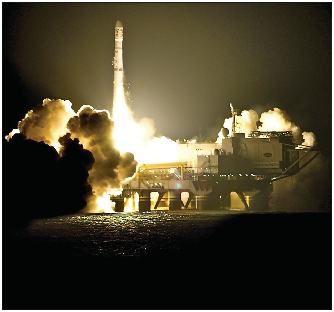
Having analyzed the trajectory of vertically oriented offshore structures leading to satellite launches, satellites with vertical remote sensing capabilities now offer insights into nighttime illumination on Earth’s surface. Light islands reveal the amphibious energy space, otherwise invisible, created and shaped by oil and natural gas. Carola Hein, in her work on the global “petroleumscape,” focused on how petroleum spatially transformed the built environment throughout its production chain, from extraction to transportation and consumption. In its commodified form, petroleum connects large segments of the economy, with spatial emanations extending from oil fields and refineries to gas stations, office buildings of oil companies and others, and the deep integration of plastics in everyday life, maintaining the petroleumscape.Footnote 87 Nighttime illumination images serve as an epistemic tool to understand and visualize an energy space through the medium of artificial light or its absence. This visual analysis provides important geographical insights into specific aspects of oil and natural gas extraction, as well as their consumption in forms like electricity generation and nighttime lighting. Earlier forms of illumination, such as kerosene lamps or coal combustion for electric lighting on warships and ocean liners, did not match the intensity or density of light islands.
On land, the energy space defined by light pollution and the erosion of what urban designer Nick Dunn called the nocturnal commons followed a different periodization, beginning much earlier than at sea. Historically, the illumination of strategic coastal locations with beacons, lighthouses, or lightships served navigation and government control. Coastal lighting has intensified since the late nineteenth century with the rise of electrification, initially in Western countries and subsequently in other regions, including colonial territories, where it disrupted nocturnal activities deemed illegal by colonial authorities, such as smuggling or aiding military insurgents.Footnote 88 Terrestrial lighting accelerated in the early twentieth century in certain parts of the world driven by coal- and hydroelectric dam-based electrification. Proponents of nighttime illumination often embraced modernist ideas that such technological advances had vanquished darkness and granted humans the power to alter the day–night cycle to an extent that it became visible from outer space.Footnote 89
Satellites equipped with vertical remote sensing capabilities have produced nighttime illumination images, currently the main sources providing insights into the Anthropocene’s light islands. These images, highlighting the nighttime illumination of industrialized marine regions, serve as indicators of access to affordable fossil fuels and associated carbon emissions. Adopting an oceanic-vertical perspective to examine the sea surface from outer space fundamentally alters terra-centric views of industrialization and socioeconomic development. This perspective underscores the impacts of fossil fuel combustion on sea surfaces and the evolving geography of light islands marking Earth’s amphibious transformation. Such illumination, dating back to at least the late 1930s in offshore pier drilling operations like those in Venezuela’s Lake Maracaibo, one of the earliest offshore oil regions discussed in the previous chapter, visualizes the human interference in the natural day–night cycle (see Figure 3.4). During the 1930s, this phenomenon was very localized but became more pronounced after the mid-twentieth century. A nighttime rocket launch is a vivid example of this. The ignition of highly refined kerosene, RP-1, or a mix including it, during each of Sea Launch’s three rocket stages – fired consecutively to propel the rocket upward – produces a massive exhaust flame.Footnote 90 This dramatic event temporarily transforms the launch platform into a light island. However, even outside of launches, the platform and control ship, as less intense light islands, are kept well-lit at night to prevent onboard accidents and collisions with other vessels. In a similar vein, offshore oil and gas platforms are brightly illuminated at night for safety reasons.
The nighttime illumination of offshore oil derricks in Lake Maracaibo, 1937. The light islands and their reflections on the lake illustrate the offshore expansion of oil drilling. This scene emphasizes the relationship between lighting, oil combustion, and socioeconomic development. Within the production process, the use of lighting, powered by fossil fuels and generators, is crucial for nighttime oil drilling.
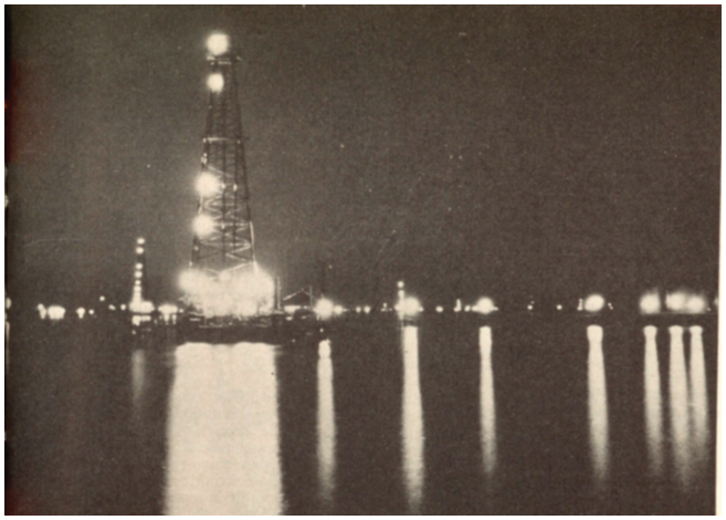
The natural gas flares from oil platforms were the strongest contributors to nighttime illumination and the creation of light island effects that visualized the oceanic Anthropocene. Prior to the 1970s, when the global demand for natural gas began to increase, most oil drillers considered it a by-product and flared it off to avert explosions and other hazards. This resulted in large gas flares that released considerable carbon emissions into the atmosphere (see Figure 3.5). Even later, offshore gas flaring continued in marine regions where the onshore transport of natural gas was deemed too complex or costly by government-owned or private companies, or if safety considerations demanded it.Footnote 91 Natural gas utilization, in contrast, is much less visible in the form of light islands. Although light islands mainly show the locations of offshore platforms that extract oil and flare the associated natural gas, their lights at least give hints regarding the locations of fields and therefore also potential other platforms that exploit gas and transport it onshore, in that case resulting in little or no noticeable flaring. Gas venting is equally problematic to track using light. When the quantities of natural gas extracted at oil fields were too minor for economic flaring or overly contaminated with pollutants, it was directly vented into the atmosphere. Venting, akin to fugitive natural gas emissions from pipelines, markedly elevated atmospheric methane levels, making it more detrimental than flaring but also invisible to both the human eye and nighttime illumination satellite imagery. Tracking then needs to switch from light to methane concentrations.Footnote 92
Gas flare from the BP Ula oil platform in the North Sea, April 1, 2012. This flare burned off natural gas not used for consumption. It strongly contributed to the light island effect. Even in daylight, it made the energy intensity of the production process very visible. At night, the flare also emphasized the amphibious energy space forged by fossil fuel drilling, combustion, and lighting that linked the terrestrial and offshore parts of the human habitat to one another.
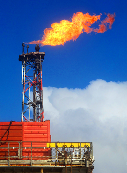
Nighttime illumination can be viewed as a form of oceanic placemaking, assigning value and meaning to otherwise abstract spaces and helping conceptualize artificial islands on the sea surface as an extension of the human habitat.Footnote 93 Just as platform crew’s confrontation with altitude through elevated platform decks led to the use of helicopters, their confrontation with darkness strongly increased the likelihood of accidents. Thus, work on offshore oil platforms involved not just conceptualizing place through altitude in a voluminous space. Material and geographical conditions also mean that placemaking happens through replacing natural time regimes with artificial human ones, culturally normalizing the practice of floodlighting among crews as essential for inhabiting sea surfaces. However, this practice also contributed to nighttime light pollution. In marine species, the absence of darkness can interfere with spawning events and zooplankton migration to the sea surface, while making prey more visible to predators. A study estimated that in 2010, already 22% of the world’s coastal regions (excluding Antarctica) saw some form of artificial nighttime illumination, thus contending with light pollution.Footnote 94
An oceanic-vertical perspective enhances the utility of nighttime lighting as an epistemic tool, broadening its applications beyond estimating carbon emissions and assessing terrestrial socioeconomic development. Historically, academic studies have employed nighttime illumination imagery only to quantify carbon emissions from gas flaring, aiming to curb the practice both offshore and onshore. Academics sometimes combine nighttime imagery with high-resolution daytime satellite photos for platform counting and in-person measurements of methane concentrations at sea level, resulting in more comprehensive estimates of natural gas flaring and venting.Footnote 95 However, the primary focus here is on the potential of nighttime illumination imagery to reveal global socioeconomic development and disparities – a technique traditionally confined to land but equally applicable to sea surfaces.Footnote 96 On land, the presence or absence of artificial nighttime illumination reflects a region’s financial resources, technical and political infrastructure, and access to electricity for lighting homes, storefronts, billboards, malls, hotel lobbies, industrial sites, street lamps, and highways. For example, the intensity of human-made nighttime lighting in sub-Saharan Africa is consistently lower than that of other continents, illuminating only the more energy-intensive fraction of the inhabited space. Another prominent, almost cliché example from the 2000s and 2010s is the substantial nighttime illumination disparity between North and South Korea, highlighting the stark economic and political differences reflected in their respective electricity consumption for lighting.Footnote 97 In the following sections, I will draw connections between these points. Light islands challenge terra-centric understandings of socioeconomic development’s defining influence on portions of the human habitat. They emphasize the amphibious extent of the highly developed part of the human habitat, unified by energy intensity as a common denominator in placemaking across genuinely different material conditions.
Earth at Night 2012 is a GIS layer derived from satellite remote sensing data depicting visible spectrum light from multiple sources, including urban lighting and offshore gas flares. Marine regions like the South China Sea, North Sea, Gulf of Mexico, Persian Gulf, Gulf of Guinea, and parts of the Mediterranean exhibit substantial light island effects.Footnote 98 These light islands differ in appearance and environmental impact from their terrestrial counterparts, their lights usually not being shielded by other structures and thus visible from great distances, while the water directly below them absorbs some of it, influencing marine species.Footnote 99 Their brightness exceeds that of lighthouses, and in certain instances, like in the Mediterranean, they have become tools for conceptualizing spatial relations. For example, illegal migrants in boats without electronic position-fixing equipment have used the light from the El Bouri offshore oil field as a navigation aid to travel northward from western Libya toward European islands.Footnote 100
Focusing on Asia’s oceanic Anthropocene, Earth at Night 2012 visualizes the patterns of nighttime illumination both offshore and on land in Southeast Asia (see Figure 3.6). In this image, created from data collected in April and October 2012, Singapore and Johor Bahru (bottom left), along with Brunei Darussalam’s coastline (center right) and the slightly less intensely lit coastline of Kota Kinabalu (Sabah, Malaysia) to its northeast, are the brightest terrestrial places. Conversely, large parts of the Malayan Peninsula and especially Borneo are low-light or dark areas. Numerous light islands, associated with oil fields and gas flaring, dot the two coastlines and could be mistaken for urban areas on land. Off the east coast of the Malayan Peninsula, one chain of light islands (the Indonesian “West Natuna” fields and, to their northwest, the brighter Malaysian “Malay” fields cluster) leads into the undepicted Gulf of Thailand (northwest). Several groups can be found situated off the northwest coast of Borneo. Two more intense light islands (top center) are located southeast of Vietnam’s almost unlit southern tip (almost top left). Anthropogenic nighttime illumination patterns transgressing land–ocean dichotomies become even more evident when the image is compared to a daytime satellite image of the region clearly showing ocean and land, including the almost unlit Indonesian Riau Archipelago next to which the West Natuna fields are located (see Figure 3.7). The light islands represent a portion of the altogether 112 consistently flaring marine areas hosting about 1,082 platforms in the South China Sea (most not depicted here), as captured in other satellite images from the same period.Footnote 101
Satellite image of nighttime illumination over a section of the South China Sea, 2012. Visible are light islands, created by offshore oil platforms, off Borneo’s coast (spanning from top right to bottom center), off the east coast of the Malayan Peninsula (to the left), and extending toward the Gulf of Thailand (northwest, not depicted). Additionally, light islands are discernible southeast of Vietnam’s southern tip, near the top center. This artificial nighttime illumination not only visualizes a portion of the usually invisible geography of oil and gas extraction and combustion but also highlights urban lighting on land, a direct consequence of electricity generation using these fuels. Thus, fossil fuels have created an amphibious energy space, both offshore and on land, which illustrates the extension of those parts of the human habitat that have undergone energy-intensive socioeconomic development. This image also serves as a poignant reminder of the associated carbon emissions, as the light islands and urban lighting together visually represent the Anthropocene and human interference with the planetary carbon cycle.
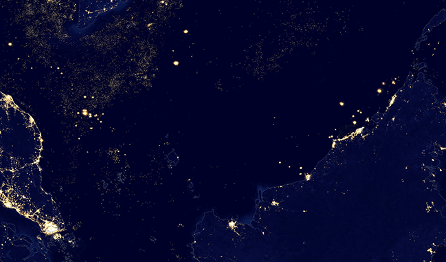
OpenStreetMap-annotated image of the same region as depicted in Figure 3.6. Borneo’s interior and the Riau Archipelago (next to which the West Natuna gas fields are located) become much more visible.
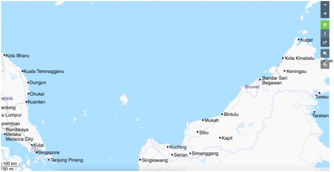
Nighttime illumination is a critical epistemic tool for comprehending the extent of the energy-intensive part of the human habitat in the Anthropocene that underwent socioeconomic development. Offshore nighttime illumination and its ecological footprint symbolize constant human presence, despite fluctuating individual compositions like rotating crews on oil and gas platforms. Reflecting on the previous chapter, these Anthropocene light islands have contributed to the fossil fuel–driven growth strategies, adding to the export revenues from oil and natural gas that have partially funded the terrestrial socioeconomic development agendas of countries such as Malaysia, Indonesia, and Brunei. These offshore activities have also provided part of the energy required for domestic development, including the terrestrial power infrastructure for nighttime lighting – a critical point in such regions as Southeast Asia where nuclear energy has played no role in electricity generation. In 2012, oil- or gas-fired power plants were the primary or exclusive electricity providers in countries such as Singapore, Malaysia, and Brunei. For example, gas from the Indonesian West Natuna oil and gas fields arrived via undersea pipelines in Malaysia and Singapore, where much of it fueled power plants. Likewise, gas from the Malay oil and gas fields is used in Malaysian and Singaporean power plants. This energy dynamic highlights the direct link between offshore light islands and urban lighting, with gas-related light indicating carbon emissions offshore on platforms or, on land, by the power plants powering urban lighting.Footnote 102 Thus, alongside urban lighting in Brunei, Singapore, and parts of Malaysia and Indonesia, light islands reflect the amphibious extension of the energy-intensive human habitat and the connectedness of offshore and terrestrial socioeconomic development.
In oceanic history periodization, the synchronization of offshore and terrestrial nighttime lighting patterns in the latter half of the twentieth and early twenty-first centuries occurred through oil and natural gas combustion. This synchronization shows the role of marine regions in the onset and intensification of the Anthropocene. Echoing the previous chapter, it is a reminder that the ocean did not experience an “Age of Coal,” which on land initiated the electrification era and urban lighting since the late nineteenth century. A central aspect of this synchronization is the emergence of the amphibious human habitat through fossil fuel–driven socioeconomic development, where intensive energy use and nighttime illumination – or their absence – became key elements of placemaking.
Sea surface placemaking has, therefore, become a defining feature of the new period in oceanic history among people involved in the extension of the human habitat onto sea surfaces. This process of placemaking is based on physical and symbolic experiences of crews and others working on or interacting with artificial islands, rooted in an everyday confrontation with the impact of Earth’s amphibious transformation. Placemaking assigns specific meanings and values to the abstract vastness of the ocean. For example, artificial nighttime illumination on light islands converted unfamiliar, geographically alien spaces into familiar ones, allowing for an association – though not an equivalence – of sea surface and terrestrial habitations. In material space, everyday inhabitation practices made the ocean more accessible, downscaling its vastness to the level of tangible bodily experiences, such as seeing and sometimes feeling, smelling, or hearing the artificial nighttime lights of artificial islands, including gas flares and bright floodlights. Beyond bodily experiences of material conditions, satellite imagery of nighttime lights also provided conceptual experiences based on symbols. As symbols of energy-intensive development, these lights give geographical identity to otherwise empty oceanic or terrestrial spaces on such images. Like other narration or mapping techniques, symbols foster imaginary associations. Nighttime lighting as a symbol, therefore, extends the association of energy-intensive development from the traditional focus on land to sea surfaces, as seen in Southeast Asia. Another physical experience was nighttime illumination as a navigation aid, marking sites of arrival and departure for ships, boats, helicopters, or space rockets. On satellite images, light islands created a corresponding symbolic experience of a production site that is in regular interaction with terrestrial sites in an otherwise vast and dark space. Placemaking also often involves acts of exclusion, as symbolized by light islands. Most light island use occurred within the Law of the Sea framework, which territorialized much of the former oceanic commons into EEZs. Therefore, these light islands indicated the exclusion of foreign activities, except for navigation. Placemaking also reflected subsequent shifts in governmental socioeconomic development agendas and corresponding spatial uses, where offshore oil and gas drilling usually took precedence over fisheries. The presence of a drilling platform now legally excludes other activities due to safety zones allocated through marine spatial planning. The very intense nighttime illumination offshore also caused physical and symbolic experiences of potentially hazardous living conditions on structures extracting combustibles and handling heavy materials, surrounded by water. A large gas flare, its light reflecting off the water, was a constant reminder of the potential for lethal accidents, including fires, explosions, capsizing, crushing, or falling overboard. Everyday activities like smoking or alcohol consumption were banned, and children, animals, and even certain plants, such as trees, which could catalyze fires, were restricted for safety reasons. Therefore, these offshore extensions of the human habitat, represented by very intense light islands, were not associated with socially acceptable living conditions but rather with development agendas necessitating such dangerous work.
Earth’s Amphibious Transformation Seen through Verticality and Light
An oceanic-vertical perspective provides multidirectional insights into Earth’s planetarity in the Anthropocene. It highlights vertical connections among sea surface–based artificial islands, the atmosphere, and Earth orbits. Therefore, it enhances our understanding of human adaptation to turbulent marine conditions with an upward focus to outer space, diverging from the maritime history’s horizontal focus on transoceanic shipping. The perspective also shows that multiple types of artificial islands were part of a placemaking process, based on physical and conceptual experiences associating, though not equating, them with terrestrial regions. This high-tech “islomania” of building artificial islands, characterized by a vertically oriented ocean platform style, took physical form in the mid-twentieth century. It evolved in a context shaped by multiple intellectual influences, evoking associations with sunken Atlantis and other imaginary islands, such as the sociopolitical thought experiment Utopia. The idea of artificial islands gained practical application with the realization by Westerners like Armstrong of a “lack of islands” for airplane refueling, leading to the proposal of using the Age of Coal’s energy-intensive construction materials for building floating airports. The trajectory, including seadrome ideas and the construction of oil platforms, eventually led to the creation of artificial light islands, with one type serving as gateways to outer space. The oceanic-vertical perspective highlighted the growing sea surface–outer space connections since the early Space Age, evident in equatorial offshore launches and mobile launch platforms that relocated multiple forms of pollution and disaster risks offshore. It also allows for an understanding of the ocean from outer space, as shown by satellite images.Footnote 103 The light island effect, one of the insights gained in this vertical way, was rooted in the combustion of fossil fuels, extending these insights further downward to the oil- and gas-bearing geological layers beneath the seabed.
Nighttime illumination varied in intensity and density across different ships and artificial islands, evolving over time and with local energy transition speeds. Along with air-conditioning and other electrical uses, it heightened this energy intensity, fueled by oil or natural gas. Early proposals for marine built environments, like Armstrong’s unbuilt seadromes, would have been prominent light islands with large searchlights and runway lighting. If one follows the branch leaving the main trajectory of vertically oriented artificial island construction, it leads to Kansai International Airport’s landfill-made artificial islands that easily exemplify this point. Earth at Night 2012 shows the airport’s clearly visible light islands.Footnote 104 More recently, the energy transition toward renewable energies is changing offshore nighttime illumination satellite images. Offshore wind turbines contribute drastically less light than gas flares do. In equatorial regions like those of Southeast Asia, low wind strength makes wind turbines less relevant, further impacting nighttime lighting. Meanwhile, equatorial rocket launches, which produce very intense light during takeoff, like wind turbines illustrate the connection among artificial island use or its absence, nighttime illumination, and the material conditions at the equator, such as Earth’s rotation and low wind speeds. Altogether, offshore launches, in particular equatorial ones using fossil fuels for their first booster stage, represent the most intense visualization of the upward-oriented spatial extension of the oceanic Anthropocene and the related physical and symbolic experiences of Earth’s planetarity.
The light islands discussed thus far are not the only ones. They are connected to each other through the upward-oriented ocean platform style. On boats and ships, advances in lighting technology create much smaller, sometimes downward-oriented light islands. Artificial nighttime illumination on fishing vessels, which lures marine organisms closer to the sea surface, serves as a prime example. From an oceanic-vertical perspective, this practice extends beneath the sea surface and reaches into outer space. Satellite images of the Gulf of Thailand reveal numerous such small light islands, particularly when vessels use large green light floodlights. This light spectrum, most noticeable to marine organisms due to oceanic material conditions, attract small marine life and, in turn, squids feeding on them, which are the primary target of such fisheries visible from outer space.Footnote 105
Finally, the formation and perception of light islands have also been influenced by coastal and recreational aesthetics, often rejecting such illustrations of industrialization. Therefore, I largely disagree with the notion that in the North Sea, “corporations and nations control the spaces of oil and gas in secrecy and concealment.”Footnote 106 Locating any offshore oil or gas platform in EU or US waters on governmental maps has become straightforward, unlike in Southeast Asian or other waters, where satellite imagery becomes more critical and governmental data are less available.Footnote 107 Moreover, the light island effect makes these platforms visible from ships and boats at night, as illustrated by the El Bouri offshore oil field and illegal migration in the Mediterranean. Oil and gas spaces are not secret or concealed, but Western beachgoers’ desire for a coastal void is a central reason, as they understandably do not wish to see or hear them – eyes that do not see, so to speak. In the West, there is substantial resistance to offshore energy infrastructures being visible or audible from recreational beaches during the day or through gas flares at night, rooted in an aesthetic preference for seemingly pristine, nonindustrial coasts. Marine built environments are typically concentrated at specific sites away from recreational beaches or, like pipelines, submerged below the sea surface and buried in the seabed.Footnote 108 However, notably, in Europe, this aesthetic has made room for offshore wind turbines not associated with pollution, visible from coasts, including some recreational beaches, in Germany, the Netherlands, and Belgium, among other countries.Footnote 109
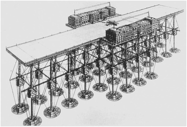
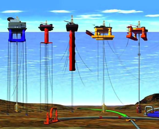
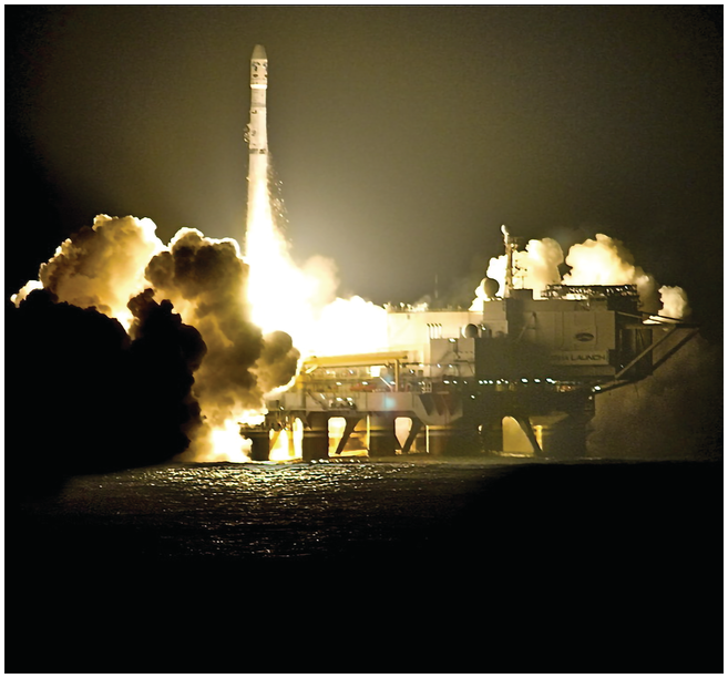
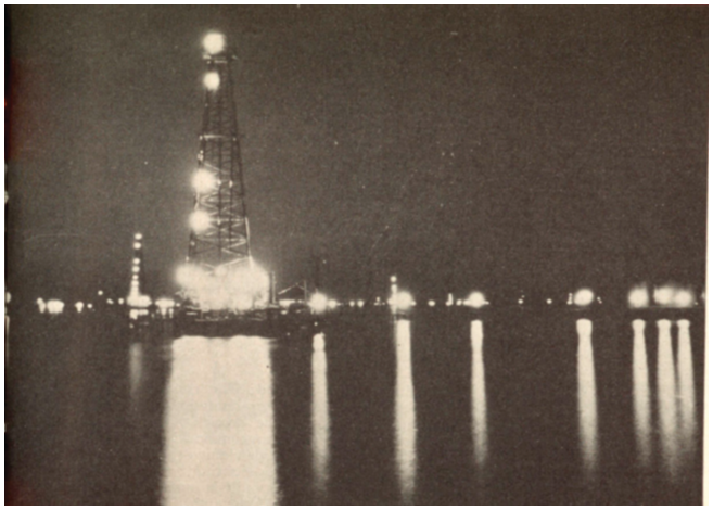
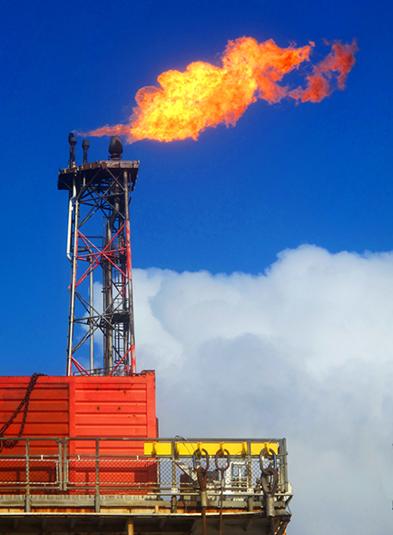
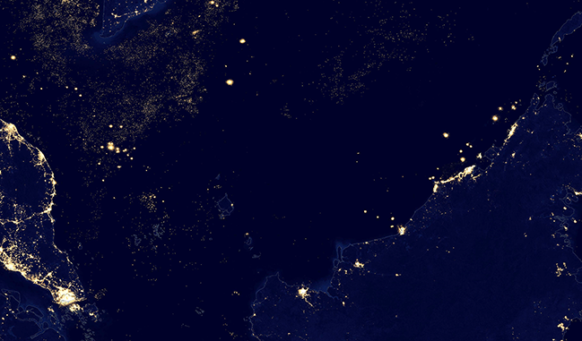
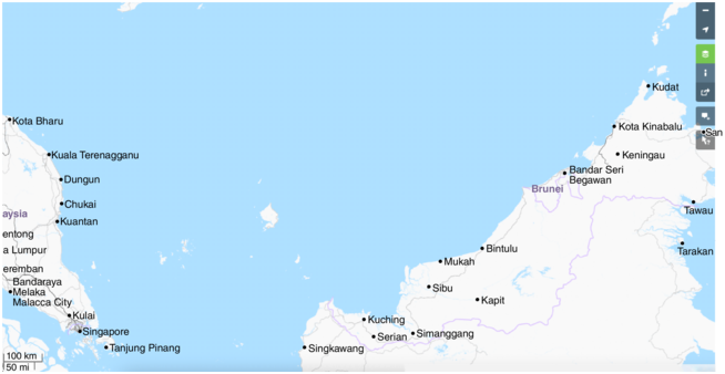

 Open access

