


The majority of archaeological work conducted in the United States today is performed within a cultural resource management (CRM) context. From 1985 to 2012, the federal archaeology program recorded a cumulative total of 883,249 sites and surveyed slightly more than 140 million acres of land, roughly 6% of the land area of the United States (Altschul Reference Altschul2016). The SRI Foundation (Reference Foundation2019) estimated CRM expenditures in the United States for fiscal year 2020 to be on the order of $1.4 billion, with roughly half of that funding archaeology and the other half allotted to historic buildings, landscapes, and monuments. Despite the tremendous amount of work that has been conducted in CRM in the United States since the passage of the National Historic Preservation Act (NHPA) of 1966, little effort has been spent on synthesizing and leveraging the resulting data.
CRM today is performed on a project basis. Emphasis is placed on documenting the results, with interpretations focused on questions appropriate to the size and nature of the project. CRM efforts have filled in many of the details of the past, but the significance and relevance of project results to the management concerns and research questions that can be addressed by them remain largely untapped. The problem becomes more acute as increasingly detailed data are collected (Altschul Reference Altschul2016; Schlanger et al. Reference Schlanger, Wilshusen and Roberts2016; Wilshusen et al. Reference Wilshusen, Heilen, Catts, de Dufour and Jones2016). What has been learned, and how is it relevant? What remains to be learned, and what methods are best suited to such endeavors (Heilen and Altschul Reference Heilen and Altschul2013)? The answer to these questions should guide how CRM practitioners in the government and private sector study the past as well as how CRM efforts can be designed to address the social, economic, and environmental challenges that societies face today and in the future.
Most CRM efforts conducted in the United States are compelled by the NHPA, in compliance with Sections 106 and 110 of the Act. Section 106 requires federal agencies to identify archaeological sites and other historic properties that may be affected by an undertaking, evaluate their eligibility for listing on the National Register of Historic Places, and consider whether eligible properties may be adversely affected. Section 110 requires that federal agencies assume responsibility for historic properties under their jurisdiction and establish CRM programs that will ensure the long-term preservation of important cultural resources and resource values. Most CRM activities only consider historic properties within an undertaking's area of potential effect and focus effort primarily on individual sites, however. Adverse effects to eligible properties that cannot be avoided are often mitigated through data recovery. With most CRM work focusing on Section 106 responsibilities, substantially less effort is placed in developing the broader and more comprehensive understanding of cultural resource distributions and values that is needed to ensure long-term preservation and decide on creative mitigation options.
Over the past two decades, archaeology has confronted a crisis in relevance, compelling the discipline to address modern-day problems from its unique perspective. Increasingly, CRM projects have revealed when and where various cultural or technological developments took place and which archaeologically or historically recognized groups were involved. Yet rarely are CRM data harnessed at a broad scale to investigate the operation and dynamics of coupled human-natural systems or to inform on modern-day social and environmental challenges. To make project results more widely relevant to researchers, stakeholders, and the public, archaeologists need to discover how and why these changes occurred and to explain change and variability in an anthropologically and publicly relevant fashion, rather than in a piecemeal and ad hoc fashion (Altschul et al. Reference Altschul, Kintigh, Klein, Doelle, Hays-Gilpin, Herr, Kohler, Mills, Montgomery, Nelson, Ortman, Parker, Peeples and Sabloff2017; Kintigh et al. Reference Kintigh, Altschul, Beaudry, Drennan, Kinzig, Kohler, Fredrick Limp, Maschner, Michener, Pauketat, Peregrine, Sabloff, Wilkinson, Wright and Zeder2014; Ortman Reference Ortman2019). Archaeologists need to demonstrate to the public what has been learned, why it is important, and how archaeology can help address the challenges that societies face today and in the future (Nelson et al. Reference Nelson, Ingram, Dugmore, Streeter, Peeples, McGovern, Hegmon, Arneborg, Kintigh, Brewington, Spielmann, Simpson, Strawhacker, Comeau, Torvinen, Madsen, Hambrecht and Smiarowski2016; Wilshusen Reference Wilshusen2019).
A viable alternative to standard CRM practice is to apply “creative” mitigation efforts that can provide greater benefit to stakeholders and the public, which is the focus of this special issue. These include activities such as synthesis of previous work, archaeological modeling, public outreach, specialized analysis, creation of archaeological preserves, and investigation of sites outside the project area with greater information potential (Larralde et al. Reference Larralde, Stein and Schlanger2016; Schlanger et al. Reference Schlanger, MacDonell, Larralde and Stein2013). Modeling and synthesis are potential creative mitigation options that can establish what has been learned thus far and be used to guide more holistic, landscape-level planning of other creative mitigation efforts. Synthesis and modeling can help stakeholders decide on what is studied, how it is studied, where there are data gaps, and how to budget and prioritize creative mitigation activities.
ARCHAEOLOGICAL MODELING AND SYNTHESIS
In 2015, a National Science Foundation project identified the “Grand Challenges” in archaeology, organized around a series of major themes and questions that archaeologists felt could be addressed over the next 25 years (Kintigh et al. Reference Kintigh, Altschul, Kinzig, Fredrick Limp, Michener, Sabloff, Hackett, Kohler, Ludäscher and Lynch2015). CRM projects can play an important role in addressing the Grand Challenges, but new methods and approaches are needed for developing, managing, integrating, and making use of disparate CRM datasets for synthesis, modeling, interpretation of resource significance, and regional planning (Doelle et al. Reference Doelle, Barker, Cushman, Heilen, Herhahn and Rieth2016; Kintigh et al. Reference Kintigh, Altschul, Beaudry, Drennan, Kinzig, Kohler, Fredrick Limp, Maschner, Michener, Pauketat, Peregrine, Sabloff, Wilkinson, Wright and Zeder2014). The relevance of CRM project results to other disciplines and the public and to informing public policy also needs to be realized. To facilitate this process, the Coalition for Archaeological Synthesis has been founded, with the goal of establishing an international center for archaeological synthesis (Altschul and Kintigh Reference Altschul and Kintigh2019; Altschul et al. Reference Altschul, Kintigh, Klein, Doelle, Hays-Gilpin, Herr, Kohler, Mills, Montgomery, Nelson, Ortman, Parker, Peeples and Sabloff2017). At the heart of all of these efforts are CRM data, including how and why they are collected and how they can be leveraged to answer important questions, inform public policy, and address stakeholder concerns.
Yet CRM activities are routinely performed in isolation, as if the only matters of interest are those of the immediate surrounding area. Many data are left isolated, are difficult to access, and lack standardization and quality control. Moreover, the research questions and methods used to collect CRM data often remain the same from project to project, and their effectiveness in achieving long-term preservation and research goals is rarely considered. CRM places a high priority on recording sites and preserving their information potential for the future. Rarely are the accumulated data and insights used to guide future management efforts. As a result, the research, educational, and traditional values of many heritage resources are left unexplored. These issues need to be addressed by both the agencies responsible for managing cultural resources and the private sector firms that perform much of the work and, ideally, in collaboration with research organizations, traditional communities, policy makers, and other stakeholders.
Recent efforts at building large, interoperable databases are under way to make CRM project results more broadly accessible and usable. The Digital Index of North American Archaeology, for example, integrates multiple state databases into a single system and allows them to “talk” to each other by standardizing typological systems and terminology through a process called ontological matching (Kansa et al. Reference Kansa, Kansa, Wells, Yerka, Myers, DeMuth, Bissett and Anderson2018). In the American Southwest, multiple thematic databases integrate data from numerous CRM and academic studies in support of landscape-level synthetic research. These efforts are allowing research problems that cannot be addressed at the scale of individual sites and projects to be addressed at the scale of landscapes and regions (Anderson et al. Reference Anderson, Bissett, Yerka, Wells, Kansa, Kansa, Noack Myers, Carl DeMuth and White2017; Kohler and Varien Reference Kohler and Varien2012; Kohler et al. Reference Kohler, Varien, Wright and Kuckelman2008; Mills et al. Reference Mills, Clark, Peeples, Haas, Roberts, Hill, Huntley, Borck, Breiger, Clauset and Shackley2013, Reference Mills, Ram, Clark, Ortman and Peeples2019).
As a creative mitigation effort, modeling can be a form of landscape-level synthesis and a precursor to the broader thematic, regional, and continental synthesis that is needed in today's CRM. Typically, the data used to inform a model were generated over many years of CRM survey, testing, and data recovery activities performed in compliance with Section 106 of the NHPA. In creating a model, it is necessary to compile and standardize data, evaluate data quality and distribution and survey representativeness, identify correlations and trends, and synthesize what has been learned (Kamermans et al. Reference Kamermans, van Leusen and Verhagen2009; Kvamme Reference Kvamme, Judge and Sebastian1988a, Reference Kvamme, Judge and Sebastian1988b, Reference Kvamme and Voorrips1990; Verhagen and Whitley Reference Verhagen and Whitley2012). Many environmental data may also be compiled and processed to derive variables useful in predicting site location or characteristics. The main outcome of modeling efforts in CRM is usually a georeferenced map identifying the archaeological sensitivity of a study area. Additional outcomes can include software tools, modeling procedures, environmental data, digitized site cards and reports, geographic information system data, and new or refined cultural resource databases (Green et al. Reference Green, Altschul, Heilen, Cushman, Homburg, Trampier, Hayden and Lerch2012; Harris et al. Reference Harris, Kingsley and Sewell2015; Heilen et al. Reference Heilen, Sebastian, Altschul, Leckman and Byrd2012, Reference Heilen, Leckman, Byrd, Homburg and Heckman2013, Reference Heilen, Altschul, Reddy, Heckman and Norris2015; Hudak et al. Reference Hudak, Hobbs, Brooks, Sersland and Phillips2002; Madry et al. Reference Madry, Cole, Gould, Resnick, Siebel, Wilkerson, Mehrer and Wescott2006). All of these efforts feed into modeling, but they also make previously inaccessible, incomplete, or disjointed data available for other creative mitigation efforts.
The data needed for modeling will often need to be integrated from multiple sources, cleaned, standardized, and analyzed. Technical analysis examining survey history, site characteristics, and environmental variables or correlations can be a rare opportunity to examine cumulative CRM datasets at a broad scale. Such examinations can lead to insights about not only how archaeological sites are distributed but how sites are best identified, recorded, and sampled. For example, technical analysis in support of modeling can show how survey methods have influenced site discovery rates as well as identify data gaps and bias in survey coverage and representativeness. Analysis of cumulative survey and testing results can also test whether our assumptions about the efficacy of survey and evaluation methods are accurate or in need of refinement (Heilen Reference Heilen2017a, Reference Heilen and Vanderpot2017b; Heilen et al. Reference Heilen, Sebastian, Altschul, Leckman and Byrd2012, Reference Heilen, Leckman, Byrd, Homburg and Heckman2013). This kind of information can help us revise our approaches and guide how CRM programs are implemented.
Archaeological Models
Archaeological models have been used for decades in CRM to guide planning efforts and help make management decisions. A major advantage of using archaeological models in creative mitigation is that they can leverage available data, expert knowledge, and insight to address the challenges faced today in CRM. These include not having the time and resources to know where important resources are located, how important they are, what condition they are in, where they are vulnerable to adverse effects, and what to do to investigate and preserve them. Archaeological models can thus be used to guide decisions about where and how to apply creative mitigation efforts. For example, archaeological models can be used to
• Depict the archaeological sensitivity of broad areas to planners and the public, without having to disclose individual site locations;
• Estimate the cost of inventory, evaluation, and/or data recovery efforts and decide on appropriate investigative methods;
• Identify where particular types of sites of interest to managers, researchers, or the public are likely to be located and where sites are likely to be surficial or buried;
• Identify where additional effort is needed or resources are vulnerable to ongoing or anticipated disturbance processes;
• Develop historic contexts and identify factors that influenced settlement and land use through time;
• Design sampling strategies for research, inventory, condition assessments, and archaeological testing programs; and
• Integrate cultural and natural resource management concerns in landscape-level planning, synthesis, and conservation.
Most CRM practitioners are familiar with archaeological locational models (ALMs). ALMs predict the archaeological sensitivity of a study area, usually by dividing it into a series of sensitivity zones, such as those of low, moderate, or high sensitivity (Figure 1). A key advantage of an ALM is that it can predict where sites, or sites of a particular type, are likely to be located in unsurveyed or undersurveyed areas, allowing planners and developers to manage risk, minimize adverse effects, and assess the costs and benefits of project alternatives early in the planning process (Altschul et al. Reference Altschul, Sebastian and Heidelberg2004, Reference Altschul, Klein and Sebastian2005; Green et al. Reference Green, Altschul, Heilen, Cushman, Homburg, Trampier, Hayden and Lerch2012; Ingbar et al. Reference Ingbar, Sebastian, Altschul, Hopkins, Eckerle, Robinson, Finley, Hall, Hayden, Rohe, Seaman, Taddie and Thompson2005; Judge and Sebastian Reference Judge and Sebastian1988; Kamermans et al. Reference Kamermans, van Leusen and Verhagen2009).
Archaeological locational model integrating surface and subsurface models created for Eglin Air Force Base, Florida (Green et al. Reference Green, Altschul, Heilen, Cushman, Homburg, Trampier, Hayden and Lerch2012).

Models can be based on theory, empirical relationships, simulation, or a combination of these approaches. Empirical models generally do not explain archaeological phenomena. They describe them objectively based on statistical analysis of a set of variables and cases using a variety of techniques. Many ALMs make use of logistic regression analysis, which results in an equation that estimates the probability across a study area of a site being found in a particular location. In recent years, machine learning has proved to be a powerful approach to developing models in archaeology and other fields, using algorithms such as random forests (Breiman Reference Breiman2001; Green et al. Reference Green, Altschul, Heilen, Cushman, Homburg, Trampier, Hayden and Lerch2012; Prasad et al. Reference Prasad, Iverson and Liaw2006). A variety of statistics, such as true positive rate, false positive rate, area under the receiver operating characteristics curve, gain, and gain over random, are used to test model performance (Kvamme Reference Kvamme, Judge and Sebastian1988b).
Many ALMs make use of proxy variables that are theoretically related to the behaviors and affordances leading to site formation. Proxy variables quantify access to resources and landscape affordances, such as topographic position, exposure to wind or solar insolation, visibility, plant habitats, agriculturally productive soils, lithic sources, or transportation systems. Variables can be calculated at a variety of scales that align with the multiple scales at which people interact with landscapes. Experimental variables can also be created to isolate specific affordances that influenced behavior and site formation (Heilen and Windingstad Reference Heilen and Windingstad2017; McDonald et al. Reference McDonald, Bullard, Britt, Ruiz, Caldwell, Ehlen and Harmon2004; Nuninger et al. Reference Nuninger, Verhagen, Bertoncello and Barba2014; Verhagen and Drăguţ Reference Verhagen and Drăguţ2012).
Variables that predict aspects of mobility can also be useful in predicting site location. For example, White and Barber (Reference White and Barber2012; see also White Reference White, White and Surface-Evans2012, Reference White2015) found that major urban centers in Oaxaca, Mexico, were located in areas predicted to contain the most intensively traveled routes in the region. To model site location in Naval Air Weapons Station China Lake, an arid area of the Mojave Desert, where mobility and land use was tethered to springs, Windingstad and I calculated least-cost paths between several hundred spring locations in the mountains surrounding our study area and used the results to estimate the intensity of travel along path segments (Heilen and Windingstad Reference Heilen and Windingstad2017). Path proximity and use intensity proved important in predicting the location of resource processing sites and temporary camps that may have been used during travel between springs. In a similar fashion, historical-period transportation routes and route intersections can be useful in predicting historical period site location, as transportation networks often influence the spatial configuration of feature systems and economic interactions (Hardesty Reference Hardesty1988; Heilen et al. Reference Heilen, Altschul, Reddy, Heckman and Norris2015; Verhagen et al. Reference Verhagen, Nuninger, Groenhuijzen, Verhagen, Joyce and Groenhuijzen2019).
Variables used in modeling can be further leveraged in creative mitigation efforts to learn something new about sites and their environment, such as how sites are related to each other and their environment. In the same way that landscape ecologists experiment with landscape metrics to study the ecological dimensions of landscapes (Cushman et al. Reference Cushman, McGarigal and Neel2008), variables developed as part of modeling efforts can be used to study how landscape characteristics influence settlement behavior, land use, interaction, sustainability, and demography.
Improvements in the quality and resolution of multispectral satellite imagery and remote sensing data have allowed researchers to experiment with another empirical approach in predicting archaeological site location, referred to as “direct detection” modeling (Chen et al. Reference Chen, Comer, Priebe, Sussman, Tilton, Comer and Harrower2013; Comer and Harrower Reference Comer and Harrower2013; Megarry et al. Reference Megarry, Cooney, Comer and Priebe2016). Direct detection modeling uses image classification methods to discretely identify possible sites, much in the way that models of natural resources use spectral signatures to identify particular minerals or plant communities in the production of forestry, critical habitat, or geologic maps. In a similar fashion, the Arizona Army National Guard is exploring methods to rapidly identify resource vulnerabilities and minimize site disturbance through the use of remote sensing data, natural resource indicators, and machine learning techniques. The goal is to predict the presence or absence of subsurface cultural deposits in areas where ground disturbance or other adverse effects are anticipated, using minimally invasive techniques (Manney et al. Reference Manney, Cushman, Kaszta, Wan, Heilen, Rego and Klucas2020).
In contrast to empirical models, deductive models attempt to explain archaeological phenomena by using theoretical expectations to predict patterns of land use and mobility and testing how well those predictions reproduce observed patterns. Deductive models include using foraging theory and ecological principles to model the temporal and spatial distribution of valued ecological resources, seasonally and with environmental change, to predict where activities resulting in site formation would have been concentrated (Reeder-Myers Reference Reeder-Myers2014; Verhagen and Whitley Reference Verhagen and Whitley2012; Whitley Reference Whitley, Thompson and Thomas2013, Reference Whitley2016). Deductive approaches have also been used to anticipate the location, depth, and thickness of buried cultural deposits (Tucker, Lancaster, Gasparini, and Bras Reference Tucker, Lancaster, Gasparini, Bras, Harmon and Doe2001; Tucker, Lancaster, Gasparini, Bras, and Rybarczyk Reference Tucker, Lancaster, Gasparini, Bras and Rybarczyk2001; Zeidler Reference Zeidler2001). Models that combine empiricism with theory and insight are likely to be more convincing to stakeholders than are purely deductive or empirical models alone (Green et al. Reference Green, Altschul, Heilen, Cushman, Homburg, Trampier, Hayden and Lerch2012). Simulation modeling could bridge the gap between empirical and deductive approaches (Axelrod Reference Axelrod and Rennard2006; Kohler and Varien Reference Kohler and Varien2012; Romanowska et al. Reference Romanowska, Crabtree, Harris and Davies2019). Simulation models start with a set of simplified formal rules for how a cultural system, economic activity, or other process operates and then simulate how those rules play out in a dynamic system under varying conditions, using approaches such as agent-based modeling (Perreault and Brantingham Reference Perreault and Brantingham2011; Premo Reference Premo2006, Reference Premo, Mesoudi and Aoki2015). Simulation modeling has been applied to a wide array of archaeological problems but has thus far been used rarely in developing ALMs, although ALM applications show promise and can be richly informative (Davies et al. Reference Davies, Romanowska, Harris and Crabtree2019; Kohler and Varien Reference Kohler and Varien2012).
While ALMs have been the main focus of modeling efforts in CRM, several types of models address additional management needs. These include buried site potential models (Bullard et al. Reference Bullard, McDonald, Sabol, Schumer, Bacon, Baker, Caldwell, Dalldorf, Jenkins, Kreidberg and Minor2011; Eckerle et al. Reference Eckerle, Ingbar, Taddie, Finley, Drews, Hopkins, Seddon, Roberts and Ahlstrom2011; Green et al. Reference Green, Altschul, Heilen, Cushman, Homburg, Trampier, Hayden and Lerch2012; Heilen and Windingstad Reference Heilen and Windingstad2017; Meyer et al. Reference Meyer, Young and Rosenthal2010, Reference Meyer, Rosenthal, Byrd and Craig Young2011; Monaghan and Lovis Reference Monaghan and Lovis2005), significance models (Cushman and Sebastian Reference Cushman and Sebastian2008; Doelle et al. Reference Doelle, Barker, Cushman, Heilen, Herhahn and Rieth2016; Fatoríc and Seekamp Reference Fatoríc and Seekamp2018; Heilen et al. Reference Heilen, Sebastian, Altschul, Leckman and Byrd2012, Reference Heilen, Altschul, Reddy, Heckman and Norris2015; McManamon et al. Reference McManamon, Doershuk, Lipe, McCulloch, Polglase, Schlanger, Sebastian and Sullivan2016; Sebastian Reference Sebastian, Sebastian and Lipe2009), vulnerability models (Anderson et al. Reference Anderson, Bissett, Yerka, Wells, Kansa, Kansa, Noack Myers, Carl DeMuth and White2017; Dore and Wandsnider Reference Dore, Wandsnider, Mehrer and Wescott2006; Heilen et al. Reference Heilen, Altschul and Lüth2018; Nicu Reference Nicu2017a, Reference Nicu2017b; Reeder-Myers Reference Reeder-Myers2015), agricultural suitability models (Gillreath-Brown and Bocinsky Reference Gillreath-Brown and Bocinsky2017; Gillreath-Brown et al. Reference Gillreath-Brown, Nagaoka and Wolverton2019; Homburg et al. Reference Homburg, Heilen, Leckman, Murrell and Vierra2014, Reference Homburg, Casey, Heilen and Vanderpot2017), and cultural landscape models (Barrett et al. Reference Barrett, Dingwall, Gaffney, Fitch, Huckerby, Maguire, Dingwall and Gaffney2007; Fairclough Reference Fairclough, Palang and Fry2003; Heilen and Altschul Reference Heilen and Altschul2019). Each of these kinds of models has a place in creative mitigation efforts by forecasting the nature and distribution of the heritage resources so that they can be effectively identified, categorized, sampled, preserved, and managed and their values can be enjoyed by researchers, traditional communities, economic sectors, and the public. In other words, models can provide a framework for guiding decisions on how, where, and when to undertake creative mitigation efforts.
Modeling is best viewed as a process that begins with the development of a baseline model that is iteratively refined with improvements in data, techniques, knowledge, and insight (Altschul Reference Altschul, James Judge and Sebastian1988; Green et al. Reference Green, Altschul, Heilen, Cushman, Homburg, Trampier, Hayden and Lerch2012). The accuracy and precision of ALMs have improved in recent years with the advent of geographic information science, advances in statistical procedures and information systems, and the increasing availability and quality of environmental data used in establishing correlations and making predictions (Kvamme Reference Kvamme and Schiffer1989, Reference Kvamme1999; Lock and Stančič Reference Lock and Stančič1995; Mehrer and Wescott Reference Mehrer and Wescott2006). During their use in CRM, ALMs have fallen in and out of favor, largely due to concerns that models can be inaccurate and result in mistakes, such as in a case where a model predicts the absence of a site when, in fact, a site is present. Another disadvantage is that the available data used to develop models are often generated over the course of many disjointed projects undertaken without a cohesive sampling strategy, methodology, or research focus (Verhagen and Whitley Reference Verhagen and Whitley2012). Variation in the quality, completeness, and standardization of available data (Ortman et al. Reference Ortman, Varien and Gripp2007) can introduce bias and error in model results. Deficiencies in CRM data, whatever their source, can lead to bias and error whether they are used in modeling or in other applications. Is it modeling that is at fault or the underlying data? If the latter, what can be done to improve the utility of existing data and the quality of data collected in the future?
Concerns regarding data quality and representativeness can be addressed as part of a modeling project. Modeling, for example, may lead to important information about where there are data gaps, where methods have worked or failed, where there is interobserver error, where greater standardization or detail is needed in recording data, and how disparate datasets or typologies can be folded into a common ontology (Doelle et al. Reference Doelle, Barker, Cushman, Heilen, Herhahn and Rieth2016; Ortman et al. Reference Ortman, Varien and Gripp2007). Modeling can lead to the compilation, organization, and synthesis of data and information that, prior to modeling efforts, existed as isolated datasets and dots on a map. In planning creative mitigation efforts, modeling can help to connect the dots and generate meaningful information, insight, and dialogue through goal-oriented interaction with cumulative CRM datasets. Moreover, using Section 110 responsibilities to conduct stratified sample survey or eligibility evaluations can improve model performance and improve knowledge of regional site distributions and characteristics. Instead of using CRM data mostly as an administrative record of individual sites and projects, modeling and synthesis of CRM data can be used in creative ways to advance research, preservation, and public benefit. CRM practitioners can learn from what has failed or worked in the past in order to improve preservation outcomes.
Combining Modeling Approaches for Priority Planning and Long-Term Preservation
My colleagues and I have proposed that several different types of models could be used together to help decision makers plan for mitigating the effects of climate change on heritage resources (Heilen et al. Reference Heilen, Altschul and Lüth2018). Climate change and development are likely to damage or destroy large numbers of important resources, many before they are discovered and recorded. For example, Anderson and colleagues (Reference Anderson, Bissett, Yerka, Wells, Kansa, Kansa, Noack Myers, Carl DeMuth and White2017) estimated that more than 19,000 recorded sites in the southeastern United States will be underwater as a result of sea level rise and coastal flooding by the end of the century, conservatively assuming a 1 m rise in sea level. The majority of resources that will be adversely affected by sea level rise have yet to be identified and recorded, let alone made subject to research or preservation efforts (Erlandson Reference Erlandson2008, Reference Erlandson2010). Another study used the state database for Georgia (Williams et al. Reference Williams, Turck and Chamblee2010) and National Oceanic and Atmospheric Administration models of coastal inundation to show not only that large numbers of recorded and unrecorded sites on the Georgia coast will be affected in the near future by coastal flooding and erosion (see, e.g., Alexander et al. Reference Alexander, Robinson, Jackson, McCabe and Crass2008; Robinson et al. Reference Robinson, Alexander, Jackson, McCabe and Crass2010) but that the most vulnerable sites are also the kinds of sites that are most highly valued by stakeholders (Heilen and Altschul Reference Heilen and Altschul2016). Due to the scale of anticipated effects and the incomplete state of survey, my colleagues and I recommended that site location, buried site potential, significance, and vulnerability be modeled to identify hot spots where important resources are vulnerable to adverse effects (Heilen et al. Reference Heilen, Altschul and Lüth2018). This information could then be used in creative mitigation efforts to prioritize identification, preservation, and research of vulnerable sites before the opportunity is lost.
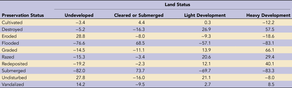
Another impending threat to heritage research and preservation is urban sprawl and infrastructure development. Modeling of time series satellite data has predicted that urban sprawl in the southeastern United States will expand by two to three times over the next five decades, causing major impacts to habitats and ecosystems that support threatened and endangered species and provide essential ecosystem services (Terando et al. Reference Terando, Costanza, Belyea, Dunn, McKerrow and Collazo2014). Cultural resources will also be affected. Altschul and I used time series land cover data (1974–2008; Natural Resources Spatial Analysis Lab 2020) and CRM data for the state of Georgia to examine the relationship between development and site condition (Heilen and Altschul Reference Heilen and Altschul2016). Between 1974 and 2008, 2.4 million acres of land in Georgia were converted to light urban (or suburban) development, and another 470,000 acres were converted to high-intensity urban development. Analysis of the correspondence between land cover and preservation status for recorded sites showed that site condition has deteriorated with increased development (Table 1). Retrodiction analysis showed that documented sites have increasingly fallen within urbanized areas since 1974, particularly within areas of low-intensity urban development (Figure 2). This trend is likely to continue in the coming decades.
Retrodiction of land use category for sites recorded in Georgia in the 2015 state cultural resource management database, based on the Georgia Land Use Trend data (Heilen and Altschul Reference Heilen and Altschul2016).

Percent Deviation from Expected Number of Sites in a Land Use Category, according to the Preservation Status of Archaeological Sites Recorded in Georgia.
To mitigate adverse effects and foster long-term preservation, creative mitigation efforts should be integrated at a landscape level with natural resource management approaches. A framework that could facilitate an integrative approach to creative mitigation is the Landscape Conservation Cooperative, established by the U.S. Department of the Interior in 2009. The program was designed to foster effective conservation and management of landscapes and seascapes that will sustain cultural and natural resources over the long term. The Landscape Conservation Cooperative is a cross-jurisdictional, collaborative framework that is intended to employ the best available science along with experience and traditional knowledge in landscape conservation (National Academies of Sciences, Engineering, and Medicine 2016). Thus far, the program has placed little emphasis on integrating cultural resources into landscape-level management initiatives and has focused primarily on natural resource concerns. The ways that natural resource management efforts identify critical habitats and conservation priorities at a landscape level are closely aligned with archaeological modeling frameworks, however. Archaeological modeling is a key way to proactively integrate cultural and natural resource planning at a landscape level (Heilen and Altschul Reference Heilen and Altschul2019). Leveraging and revising state databases using a problem-oriented approach that folds consideration of cultural resources into landscape conservation design will also be important (Murtha et al. Reference Murtha, Lawres, Mazurczyk and Brown2019). Doing so would allow cultural and natural resources to be considered together in landscape-level conservation and management and provide an arena for collaboration and cross-fertilization among social science and environmental disciplines.
Efforts to integrate and synthesize CRM, natural resource management, and traditional knowledge are rare but are certainly possible. For example, the Coalition for Archaeological Synthesis is sponsoring two proof-of-concept projects that are investigating coupled human-natural systems to address pressing scientific and public policy concerns (Altschul and Kintigh Reference Altschul and Kintigh2019). The first, referred to as the ArchaeoEcology Project, is organized by Stefani Crabtree of Pennsylvania State University. The project is integrating archaeological, ethnographic, ecological, and other data in a series of case studies to reconstruct deep-time ecological networks that will be used to investigate how humans can sustainably interact with the ecosystems on which they depend. The second project, organized by Evan Larson of the University of Wisconsin–Platteville, addresses how fires are managed in the borderlands region of the United States and Canada (Larson et al. Reference Larson Evan, Kipfmueller and Johnson2020). Current approaches to fire management rely on the concept of “wilderness,” ignoring the pivotal role that humans have traditionally played in managing ecosystems. The result of the current management approach has been larger, more frequent, and more destructive forest fires. To learn how people have managed fire in the past, the project is investigating long-term interactions among people, landscapes, and fire through collaborative synthesis of traditional knowledge with archaeological, ethnographic, forestry, and tree-ring data. CRM data are being used to reconstruct past land use and human-environment interactions, and their use in the project has also inspired new approaches to combining traditional and scientific perspectives in support of more effective stewardship (Altschul and Kintigh Reference Altschul and Kintigh2019).
DISCUSSION
Since passage of the NHPA, vast areas of land have been surveyed in response to federal undertakings (Altschul Reference Altschul2016). Yet only a fraction of federal landholdings have been surveyed. The percentage of state, county, or municipal land that has been surveyed is considerably smaller, given that the majority of activities are the result of federal undertakings. The amount of private land that has been surveyed is smaller still. As such, there are major gaps in our basic knowledge of where archaeological sites are located and what their characteristics are.
These knowledge gaps are not likely to be filled following standard practices. Altschul (Reference Altschul2007) estimated that at current survey rates it would take until AD 2175 to completely inventory the 41 million acres of land administered by the Department of Defense, for example. Another 200 years would be required to evaluate the resources, and another 250 years to treat them. Similarly, Surovell and colleagues (Reference Surovell, Toohey, Myers, LaBelle, Ahern and Reisig2017) estimated that it will take from one to several centuries to complete identification of sites across the state of Wyoming. More importantly, they note “that discovery represents only the start of the archaeological research endeavor, and although we have placed high value on discovery, it is probably the least interesting and least important part of what we do” (Surovell et al. Reference Surovell, Toohey, Myers, LaBelle, Ahern and Reisig2017:10).
The main focus of CRM has been to identify and record sites on an as-needed basis and not to fold CRM efforts into broader management approaches and research agendas. Altschul observed that
cultural resource management in the United States is a project-driven enterprise. Each project is independent, even if it is adjacent to or overlaps with another project. Although much is made of ensuring that every archaeological site is evaluated within the proper historic context, in truth, there is very little incentive in cultural resource management to “think big.” For decades, federal agencies have instructed consultants that they are not to conduct research, only cultural resource management, as though one can do the latter without the former [2016:70].
How can archaeologists identify data gaps and address important research questions if they do not “think big”? Fulfilling the legal mandate and spirit of the NHPA requires that CRM practitioners look beyond individual projects and start thinking creatively about managing resources at a landscape level, not at the level of individual sites. The answer to preserving heritage is not going to come from simply surveying more area, improving survey standards, or protecting more sites, although such efforts are needed (Altschul Reference Altschul2016; Doelle et al. Reference Doelle, Barker, Cushman, Heilen, Herhahn and Rieth2016; Wilshusen Reference Wilshusen2019; Wilshusen et al. Reference Wilshusen, Heilen, Catts, de Dufour and Jones2016).
Lipe's (Reference Lipe1974, Reference Lipe1984, Reference Lipe, Sebastian and Lipe2009) vision for conservation archaeology has been a guiding light behind CRM in the United States. He has argued that management programs should be preserving a representative sample of sites for future research. Much of the archaeology in the United States is not subjected to federal preservation law, and the archaeology that is subjected to federal preservation law is unevenly distributed. Following traditional survey methods, survey will not be completed before many important sites are damaged or destroyed. From a purely statistical perspective, how can a representative sample of sites be preserved if it is unknown where most sites are located, how they may be valued, and where they are vulnerable to being damaged? How can land managers and stakeholders decide which sites to study or protect and where to look to fill data gaps (Schlanger et al. Reference Schlanger, Wilshusen and Roberts2016)?
Archaeologists, planners, and policy makers need to address the adverse effects to sites that are currently happening on a massive scale as a result of development and climate change. Creative mitigation through modeling is one tool that can help. Standard approaches rarely consider sites outside a project area that are also threatened by adverse effects. With climate change, development, and other ongoing disturbance processes, many sites may no longer be of sufficient integrity for future stakeholders and the public to derive benefit from their heritage values by the time they are investigated or treated (de Jager Reference de Jager, van den Dries, van der Linde and Strecker2015; Willems Reference Willems2012; Williams Reference Williams, van den Dries, van der Linde and Strecker2015). Modeling and synthesis of the available data as part of creative mitigation efforts is necessary to address these issues.
Effective creative mitigation using modeling needs to be planned at a landscape level that transcends individual projects and sites and guided by municipal, state, and federal needs and requirements. Since CRM efforts follow state guidelines and states are mandated to develop preservation plans and lead preservation efforts, modeling efforts should be integrated into preservation plans and regularly updated with new data, techniques, and insights.
To apply models in creative mitigation planning and decision making, a series of steps are needed:
• Stakeholders need to be consulted to gain a better understanding of how resources are valued and to identify preservation challenges and opportunities and the kinds of data that will be needed to address them.
• Data collection methods and standards need to be developed and revisited to ensure that useful, durable, and digitally accessible data are being collected consistently.
• Data need to be collaboratively managed, analyzed, and synthesized at the level of landscapes and regions.
• Models predicting site location, significance, and vulnerability need to be built, tested, and periodically updated or refined.
• Planning tools need to be developed that integrate models with environmental and built environment data within a spatial and temporal framework.
• Adequate funding is needed to support these efforts.
To meet these kinds of needs, the Arizona Army National Guard is developing a centralized system for collecting and managing cultural resource, environmental, and other data; using those data to model cultural and natural resources within an integrated, cross-disciplinary, and collaborative framework; and making data, models, and planning tools available for project planning within a web-based geographic information system viewer. These efforts include modeling of cultural resource distributions, buried site potential, cultural landscape elements, erosion, vegetation, focal species habitat, and connectivity among focal species habitats. Disturbance regimes resulting from climate change and development will also be modeled to predict where cultural and natural resources are likely to be impacted by individual projects as well as cumulatively over time (Manney et al. Reference Manney, Cushman, Kaszta, Wan, Heilen, Rego and Klucas2020). The program is being developed by agency staff; multiple CRM firms; and teams of ecologists, geographers, and information technology specialists using a geodesign framework (Steinitz Reference Steinitz2012) that will enable consideration of the entire resource base from a long-term, landscape perspective.
CONCLUSIONS
Over the last decade it has become evident that our standard site-by-site mitigation model will be insufficient to meet future challenges. Many important resources will not be identified before their information potential or other heritage values are lost. The temporal and spatial scales of adverse effects stemming from climate change and development are beyond the reach of standard CRM efforts. Narrowly focused, business-as-usual approaches are not a viable option in resource management. Creative mitigation efforts that make use of modeling and synthesis are needed to predict and address these anticipated impacts in thoughtful, practical, and proactive ways that can be integrated with natural resource management efforts. To anticipate and plan for the impacts, CRM efforts cannot survey and evaluate everything. There are not enough resources and time to do so. CRM efforts need to shift from asking the same questions and collecting the same data on a project-by-project basis to using modeling and synthesis to guide and improve future CRM efforts. Synthesizing the accumulated data and modeling resource trends and vulnerabilities are needed to make proactive, practical, and creative decisions about which resources are most important, how they are related to each other, where survey and specialized studies are needed, how much time and money these efforts will require, and where synergy can be achieved in optimizing preservation outcomes, before it is too late. Synthesis and modeling, at the scale of landscapes and regions, are essential to charting a path forward and prioritizing preservation and research through creative mitigation.
Acknowledgments
I would like to thank John Douglass and Shelby Manney for inviting me to participate in this volume. I would also like to thank Sarah Herr for providing direction on improving the article's discussion section, several anonymous reviewers for their helpful comments, and Eglin Air Force Base and the Georgia Historic Preservation Division for supporting modeling efforts illustrated in this article. I would further like to acknowledge the extraordinary efforts of the Arizona Army National Guard in supporting the use of modeling in project planning and resource management and, specifically, to thank Shelby Manney and Brian Miller for their vision and insight in developing innovative approaches to resource management.
Data Availability Statement
No original data were used in preparing this article.


 Open access