Introduction
Several ice cores have been recovered from Agassiz Ice Cap, Ellesmere Island, Northwest Territories, Canada, since 1977 (Fig. 1) and have revealed valuable information about past climatic and environmental change over the last 100 000 years (e.g. Reference Koerner and FisherKoerner and Fisher, 1982, Reference Koerner and Fisher1990; Reference Fisher, Koerner and PatersonFisher and others, 1983; Reference Barrie, Fisher and KoernerBarrie and others, 1985; Reference BourgeoisBourgeois, 1986; Reference Fisher and KoernerFisher and Koerner, 1988, 1994; Reference Koerner, Bourgeois and FisherKoerner and others, 1988). These studies have concentrated on δ 18O, solid conductivity (ECM), pollen and melt-layer analyses. From a study of the liquid conductivity and pH at this and another site further north in northern Ellesmere, Reference Koerner and FisherKoerner and Fisher (1982)and Reference Barrie, Fisher and KoernerBarrie and others (1985)found that Arctic air pollution had increased the acidity (pH) of winter snow in this area from a several thousand year mean of 5.48 before the 1950s to a pH of 5.23 since then. However, detailed analysis of the ion chemistry of neither the cores nor the recently deposited snow and firn has been undertaken. It is therefore the purpose of this paper to present and discuss the results of the first investigation into the ion chemistry of snow deposited over the past few years at this site. Wediscuss the within-site variationdue to very local depositional variations; the between-site variationin order to determine the effects of scouring on snow chemistry; and the between-year variationdue to post-depositional processes. Results of a study of ice-core chemistry from a new ice core covering the last 100 years of deposition at this site will be published separately.
Physical Processes in the Snowpack
Physical processes that occur within and at the surface of the snowpack might also be expected to affect the original distribution of ions within that snow.
1. Snowdrifting
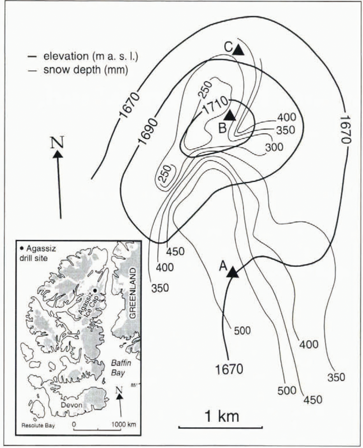
Local variations of snow deposition occur due to snowdrifting. Drifting is most intense during storms when wind velocities are high, temperatures well below freezing and any new snow is of non-dendritic form. The snow grain is then lessable to resist drifting by locking to other snow grains on deposition. The low temperatures also substantially slow processes whereby snow grains sinter together (Reference Male and ColbcckMale, 1980). The cold, dry conditions of winter are therefore the most favourable for promoting drilling of surface snow whether there is precipitation or not. The balance between snowdrift deposition and scouring generally favours high snow accumulation on downwind slopes, but low accumulation at the top of the slope or on an isolated knoll (Reference Gow and RowlandGow and Rowland, 1965).Thus, there is a low accumulation rate (10 g cm−2year−1at the very top of Agassiz Ice Cap at site B (Fig. 1), but a higher accumulation rate (18 g cm−2year−2) downwind at site A below (Reference Fisher, Koerner and PatersonFisher and others, 1983; Reference Fisher and KoernerFisher and Koerner, 1988, 1994). Site C is situated on a slope facing the prevailing wind.
Sample sites (А, В, С) on Agassiz Ice Cap, northern Ellesmere Island. The heavy contours are elevation (m a.s.l.), the light contours are snow depth (mm) measured in Apil for the years 1988–90. The snow depth represents snow accumulated between the end of melt in one year and April in the next. They serve to snow the snow-accumulation variations in the area discussed in the text. The 1977 drill site is close to site A, and the 1984 and 1987 drill sites are close to site B.
One effect of scouring is that while regular seasonal variations of the stable isotope δ 18O are present in the snow/firn pack at site A, they are almost completely missing from the topmost site, B (Fig. 2). One aim of the present research is to determine if scouring has a similar effect on snow chemistry in this area.
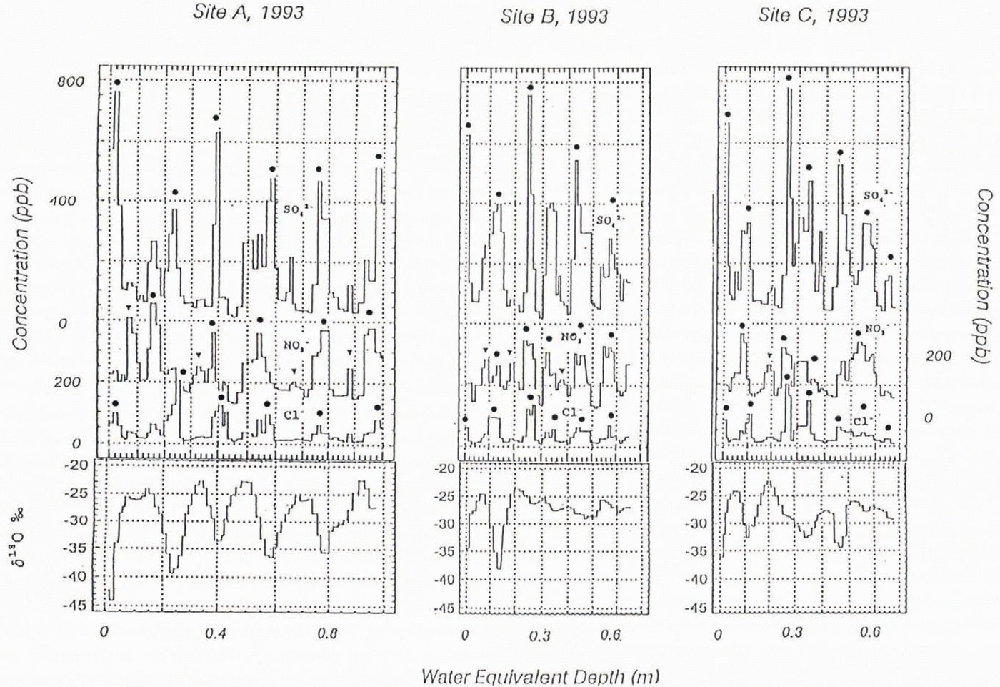
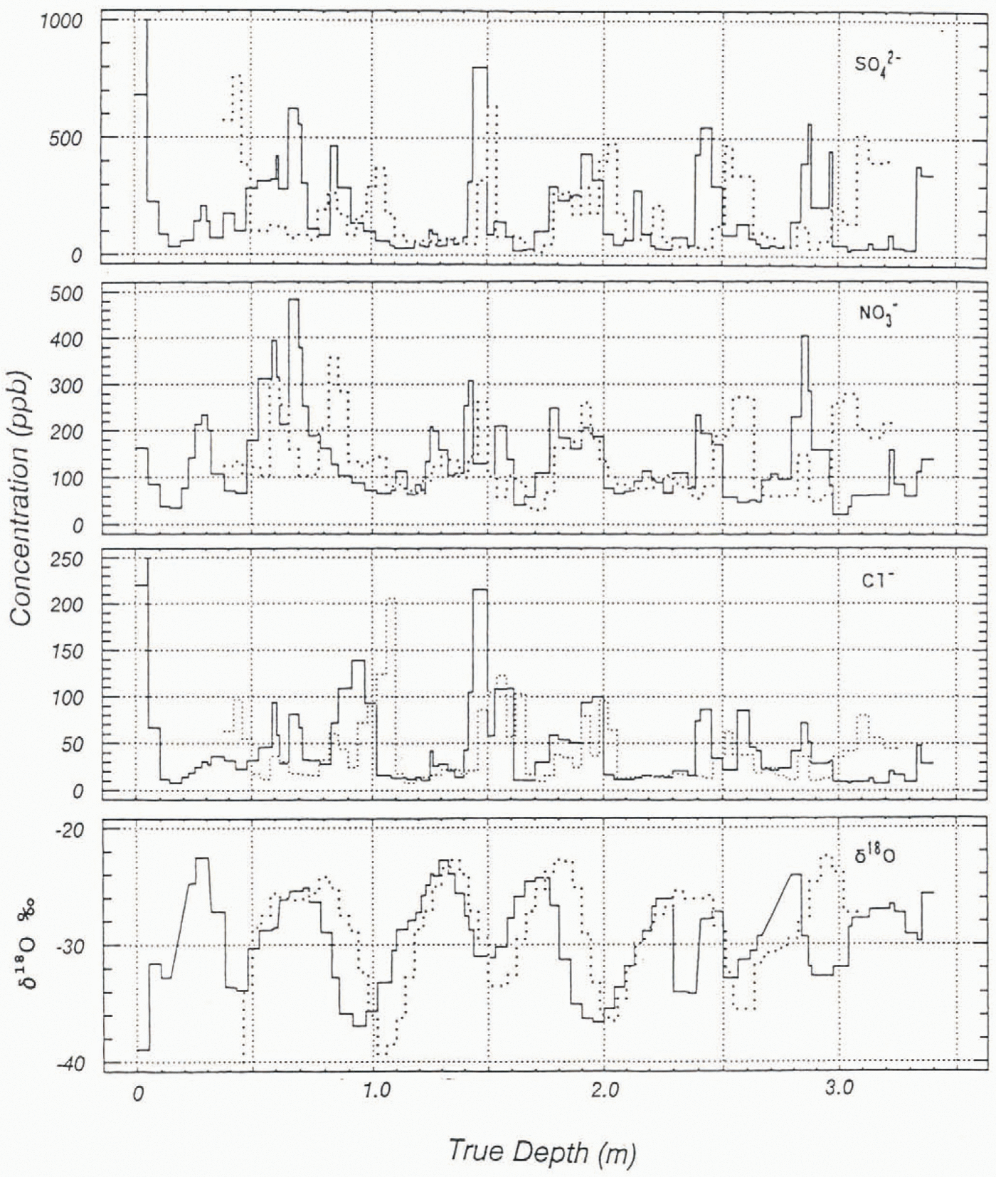
δ 18O and anion concentrations of the pits dag at sites A, B and C in April 1993. The triangles denote NO3−summer peaks (where detectable), and the shared circles represent the annual (spring) ions peak.

2. Melting
Melting of snow at the stuface in summer, followed by percolation and refreezing at depth, also promotes local variations in the stratigraphy. This is particularly true if the melting occurs early in summer when snow below the surface is still well below freezing point (Reference KoernerKoerner, 1970). Melt-water percolation in this case is very irregular. While some fairly uniform horizontal ice layers may form, vertical ice glands and isolated ice lenses also develop and introduce high irregularity into the firn/snow stratigraphy if the percolation penetrates deep into the firn below (Reference KoernerKoerner, 1970).
Another, more homogeneous melting process also occurs, but is usually confined to the uppermost 10% of the snowpack each summer on Agassiz. Ice Cap. In this case a surface melt layer is formed during the melt period by a process of daytime melt and night-time (low sun) refreezing. This diurnal cycle causes the development of a layer with a density of approximately 0.4 g cm−3composed of spherical firn grains. Both melting processes might he expected to redistribute ions within the snow pack affected by that melting.
3. Metamorphism
We use the term “metamorphism” with respect to textural changes effected by vapour transport driven by thermal gradients in the snow. The most common pattern of snow structure in the annual snow layer within the uppermost 5 m of the snow/firn pack of Agassiz Ice Cap is one of fine-grained snow/firn, with a density of about 0.35 g cm−3overlying a coarser layer with a density of about 0.2–0.25 g cm−3. The fine-grained layer, which constitutes about 30% of the annual layer, has more rounded snow grains than the highly metamorphosed hoar-like grains in the layer underneath. The coarse nature of the lower layer is caused by (summerend )temperature gradient metamorphism in loosely deposited, large-snow-grain fall snow, overlain by fine-grained, colder snow Reference KoernerKoerner, l970). Vapour transport is much lower in winter due to the nature of the tighter, drift-affected, snowpack and the substantially lower temperatures (0° to −10°C in fall compared to <−20°C in winter). The upper layer is therefore largely unaffected by vapour metamorphism. The question is whether this process has any effect on snow chemistry.
Sample Collection and Analysis
Sample collection
Pit-wall snow samples were collected from Agassiz Ice Cap (80.7° N, 73.1°W in late April-early May 1992, 1993 and 1994. Sampling sites are shown in Figure 1. Samples were taken from sites A and B in all three years, while samples from site C were taken only in 1993. Site A is located in the non-scoured zone, while sites B and C are in the scoured zone.
After observation of the snow stratigraphy in each pit (Fig. 3), samples were collected from a pre-clcaned wall of the pit using a plastic scoop or a stainless-steel knife, previously cleaned by soaking in ultra-pure water. Pit-wall samples were taken vertically, and continuously, from the snow surface In depths of 1.5–3.5 m. The vertical sample lengths were 4–0 cm. In 1993, two additional sets of samples were collected from each pit to assess spatial variations of snow chemistry. Samples were taken down three vertical sections, 1 m apart, from each of the three pits. The samples were placed into Whirlpak bags and melted either in the field or in the Geological Survey of Canada (GSC) laboratory in Ottawa. Part of the sample in each Whirlpak hag in 1992 and 1993, and all of the 1994 samples were decanted into pre-cleaned plastic bottles for transport to Japan. In 1992 and 1993 the remainder was left in the Whirlpak bags, which were kept frozen in Ottawa. The bottled samples melted during transport to Japan in 1992 and 1994, while in 1993 they arrived frozen. Apart from this the samples were kept frozen until ready for analysis.
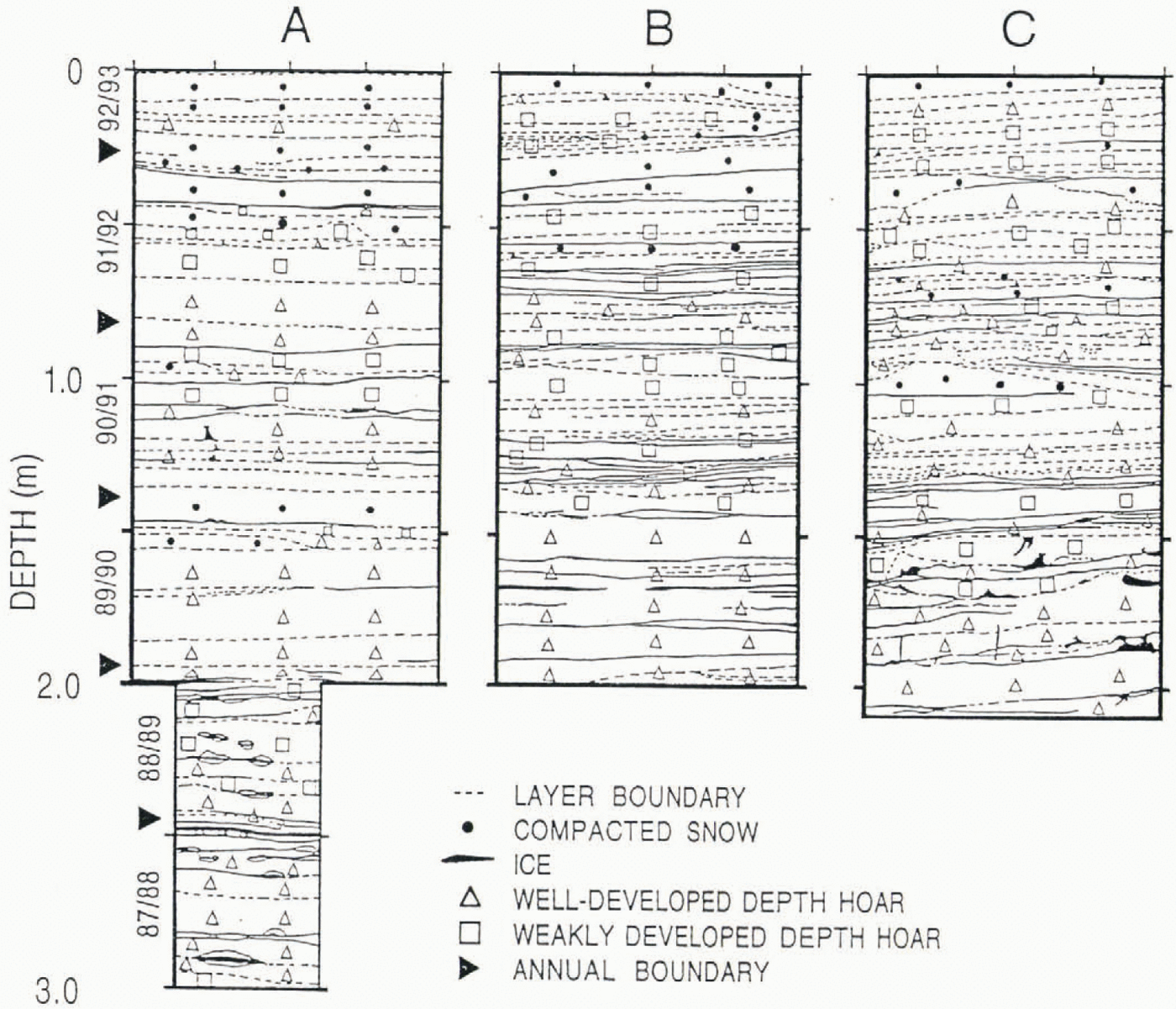
Stratigraphy at the three sites dug in 1993 . Note the higher number of higherss number of layer in the pits at the scoured sites (B and C) compared to those at the unscoured site (A). This is due to a higher frequency of drifting events at the scoured sites.

Laboratory analysis
Cl−, NO3−, and SO2−4, were analyzed using a Dionex model Dx-100 ion Chromatograph in the Nagaoka Institute of Snow and Ice Studies (NISIS). For the purpose of interlaboratory comparisons, some samples were also analyzed on a Dionex 2000i ion Chromatograph at the GSC. The GSC Chromatograph detection limit is 10 ppb, and above this level of concentration the results are within 10% agreement. The NISIS Chromatograph detection limit is 1 ppb. No detectable differences have been found between duplicate samples that remained frozen in Ottawa and those that melted during transport to Japan.
Na+was analyzed for some of the samples on a Perkin Elmer 603 Atomic Absorption Spectrophotometer with graphite furnace at the GSC. One set of samples from each pit dug in 1993 and samples from each pit dug in 1994 were analyzed for δ 18O at the Institute for Hydrospheric Atmospheric Sciences (Nagoya Universiiy in Japan, using a Finigan MAT-250 mass spectrometer.
Results and Discussion
Within-site variations
Before discussing the seasonal pattern of ion concentrations in the pits, we will first examine the scale of variation within each pit.
(a) Unscoured site (A)
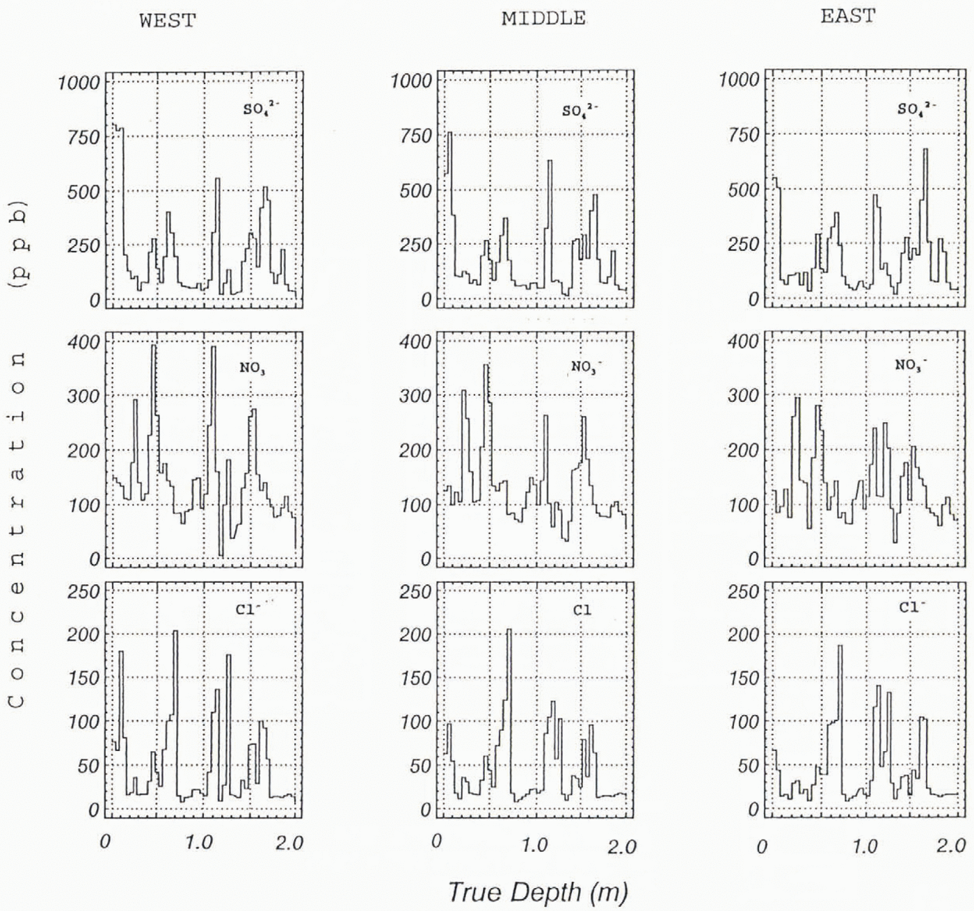
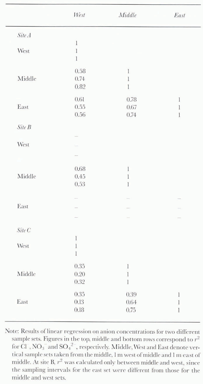
The three profiles for this site are shown in Figure 4. Table 1lists the r 2values between each of the three sets. As might be expected, the correlation is lowest between the outermost and therefore most distant sets. Most of this variation is due to the effect of snowdrifting. which produces uneven stratigraphy. However, direct correlation using depth as a common variable underscores the similarity between the profiles. All the profiles include the characteristic seasonal variation of each ion with depths of corresponding peak concentrations, all within 10 cm depth of each other.
Comparison of anion concentrations of three sets of samples collected frmo the pit dug at site. A in 1993. The west, middle and east sets are separated by 1m, respectively.
Correlation coefficients at sites A, B and C, 1993
(b) Scoured sites (B and C)
The r 2values for the three profiles at each of the two scoured sites (Table 1) are lower than for the unscoured site, with the lowest values of all three pits at the scoured site C on the north-facing slope. This site is affected by both the predominant, general-circulation northwest winds and local downslope winds. The scour at this site is no greater than at the upper site B, most probably because the local winds replace some of the snow removed by those from the northwest. However, it means snowdrift is most common at this site; the snow stratigraphy also showed the greatest irregularity there. The comparison between the scoured and unscoured sites is evidence of the variability caused by snowdrifting. It indicates that a single profile in the scoured sites would miss some seasonal cycles in a long ice core. In subsequent discussions we present only the profiles with the clearest seasonal signals.
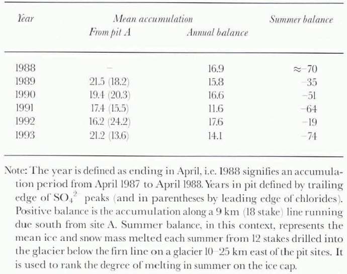
To investigate the effect of melting on both the spatial and temporal variation of snow chemistry, we use measurements of summer melting taken from a profile down a nearby glacier, 10–25 km from the snow-pit sites (Table 2). The argument we use is that the more negative the balance on the nearby glacier, the greater the melting at the three pit sites. Snow-accumulation and temperature records, collected from the nearby automatic weather station since 1989, have shown that summer melting occurs at a time when the seasonal ion peaks, in the surface annual snow layer, are about 10–15 cm deep. The melting might be expected to reduce the height of these peaks by moving some of the ions deeper into the snowpack. However, we find a very poor relationship between the height of the ion peaks and the balance values. The melting on the glacier was well above average in 1991, and some Ice lenses are seen in the firn representing this annual layer (Fig. 3). However, the ion peaks below this summer melt layer seem unaffected; they are generally the highest ion peaks in the scoured area. On the other hand, the 1992 summer, one of very low melt, does not have unusually high spring ion peaks beneath it.
Comparison between pit and surface stake measurements (g cm−2year−1)
We conclude that in an area where melt affects only about 5% of the annual layer, chemical signatures in the snowpack are not disturbed sufficiently to prohibit their use in the detection of seasonal signals.
Between-site variation
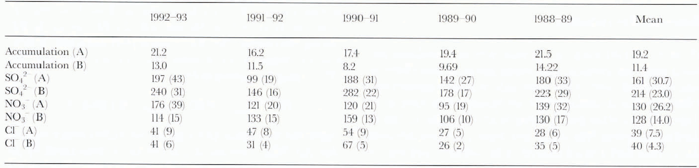
We first compare values for annual snow accumulation derived from the position of seasonal peaks of two different ions in the pits with those from stake/board measurements (Table 2). Accumulation rates are measured at each of 12 stakes along a 9 km line running south from site A, and at similar elevations. The depth and density of snow between the surface and a board placed on the surface each year is measured each year. The annual accumulation rales derived from site A differ according to the ion used as an annual marker in the pit profile (Table 2). This averages out to the same multi year value between each ion. However, the year-to-year variations, which we believe are faithfully measured by the multiple stake/board measurements, are not in good agreement with the single pit equivalents. The mean accumulation rate derived from the stake/board measurements is also significantly lower than that from the pit study. We conclude that one pit is unlikely to record accurately either the year-to-year variations or the accumulation rate for anything more than a local area. This is true even though the Agassiz Ice Cap area covered by the stake/board network is of gently undulating topography with an elevation range of >50 m.
The anion concentrations are shown together with δ 18O in Figure 2. Summer and winter seasons correspond to less and more negative δvalues, respectively. At all the sites, both Cl−and SO42−ions reach maximum concentrations in late winter/early spring. Occasionally, Cl−peaks slightly earlier than SO42−. Studies by air sampling at nearby Alert have shown that concentrations of the Cl−ion peak in winter slightly before the SO42−ion (Reference Barrie and HoffBarrie and Hoff, 1985; Reference Barrie and BarrieBarrie and Barrie, 1990). Synchronous timing of the two ion peaks in this pit is probably due to a sampling resolution too coarse to separate the real peaks. Recently acquired autostation snow-depth/temperature recordsfrom the same site are presently being used in comparison with a detailed snow-sample δ 18O data set. The results obtained so far show that the most negative δ’s occur at the end of February and in early March. As far as the resolutions allow, it appears that the ion concentrations in both air and snow show similar timings.
The Cl−/Na+ratios (2.1; σ= 0.64) are close enough to marine ratios (1.82) to indicate that both of these ions are primarily from sea salt. We use only the Cl−1ion in the following discussion. The SO42−ion is predominantly of non-sea-salt origin if we assume that sea-salt sulphate, (nss SO42−) may be estimated from
Again this is in agreement with earlier studies which suggest that the SO42−acrosol in the Arctic is dominated by its anthropogenic component (Reference Barrie and HoffBarrie and Hoff, 1985; Reference Barrie and BarrieBarrie and Barrie, 1990). The acidity of snowin northern Ellesmere (which is largely determined by the SO42−ion) in fact increased rapidly to modern levels beginning in the early 1950s (Reference Koerner and FisherKoerner and Fisher, 1982; Reference Barrie, Fisher and KoernerBarrie and others, 1985) due to long-range transport of industrial pollutants shown to originate in Eurasia (Reference Rahn and McCaffreyRahn and McCaffrey, 1980). The range of concentrations among the three anions is greatest for SO42−. In the unscoured pit, although the difference between the means for the SO42−and NO3−ions is only 23% (Table3), the SO42−peaks are more than twice as high. The Cl−ion has the lowest concentration (Table 3).
Accumulation in g cm−2year−1, concentrations in ppb (ng g−1), and fluxes (in parentheses) in mg m−2year−1at sites A and B, in pits dug in 1993

The seasonal deposition of NO3−is more complex. Although some of the NO3−peaks coincide with those of the other two anions, other years show a later peak, probably in late spring, together with a much later, summer peak. Coincidence of some NO3−peaks with SO42−and Сl−peaks may again be due to poor resolution in sampling, but could also be due to low snowfall rates in the spring of those years. In southern Greenland, Reference Finkel, Langway and ClausenFinkel and others (1986)found that NO3−formed a major, single peak in summer in pre-industrial firn layers. In firn deposited since the 1950s they found an increase in SO42−concentrations in late winter/early spring; however, the peak season remained the same (Reference Finkel, Langway and ClausenFinkel and others, 1986). In central Greenland, Reference Whitlow, Mayewski and DibbWhitlow and others (1992)reported additional peaks of NO3−occurring prior t0 the δ 18O maxima, in recent snow s. On the other hand, Reference Laj, Palais and HLaj and Palais (1992)who analyzed a core from the same region in central Greenland, reported that NO3−peaked each summer throughout the last 250 years and that NO3−had increased dramatically due to the impact of anthropogenic emissions. NO3−peaks in both summer and late winter/early spring on Agassiz Ice Cap (Figs 2, 4 and 5), so it is expected the earlier annual peak may be attributable to anthropogenic emissions. The timing of the seasonal NO3−signal at site A shows a greater similarity with the peroxyacetylnitrate (PAN) signal than with the aerosol NO3−one from air sampling at nearby Alert ( Reference Barrie, Wollf and BalesBarrie, 1996). However, differential scavenging of the various compounds means that their seasonal timing and relative concentrations need not be the same between snow and atmosphere (Reference Barrie, Wollf and BalesBarrie, 1996).
We now discuss some characteristic differences and similarities between the δ 18O and ion profiles from each site. One vertical profile from each of the sites is shown in Figure 2, together with the stable-isotope values (δ 18O). The most striking difference between the three sites is the characteristic seasonal pattern of δ’s at unscoured site A, the reduced amplitude at C and the very subdued amplitude at the topmost site, B. The reduced amplitude at the top has been previously explained by scouring of very negative-δsnow from B and C (Reference Fisher, Koerner and PatersonFisher and others 1983; Reference Fisher and KoernerFisher and Koerner, 1988, 1994). Indeed, the mean δvalue of the snow is higher at scoured site B than at unscoured site A. which would be expected if it is the winter snow that is removed, rather than snow from summer, fall or spring.
However, the Cl−and SO42−peak concentrations, which coincide very closely with the most negative-δsnow at unscoured site A, are still evident at almost the same high concentrations at B and C (Fig. 2). Furthermore, despite similar snow-accumulation rates (i.e. similar scouring) at B and C, the δvariations are much more pronounced at the down slope scoured site C (Which has a similar snow-accumulation rate to that of site B). Lower peak concentrations of the NO3−ion at the scoured sites suggest that snow removal by scour may be most pronounced in late spring (April, early May) when peak concentrations of NO3−are forming in the snowfall. Scouring at this time might also cause the NO3−peaks for spring and summer to “blend”, thereby explaining the paucity of summer NO3−peaks at sites B and C. However, this alone would not explain the very reduced δamplitude at site B. As this is the most exposed site (at the top of the highest small dome in the area) it is possibly exposed to the greatest near-surface air turbulence. Reference Clarke, Fisher and WaddingtonClarke and others (1987)have discussed the physical implications of wind-pumping in the upper layers of firn on Agassiz Ice Cap with respect to its thermal structure. Such turbulence could also cause increased vapour and, possibly, molecular diffusion. Slightly more negative summer δsnow at the more turbulence-affected sites B and C suggests this may be the ease. However, this remains an incomplete explanation. We suspect that dry deposition may be the answer. In this case, ions accumulate on a frequently windswept (but not necessarily scoured) surface. Snow does not accumulate at sites B and C, but does at site A. Site A therefore presents a continuous δ 18O profile unlike the other two sites. Future comparison between snow-accumulation and temperature records from the autostation, on the one hand, and detailed δsnow and snow-chemistry records from nearby may help to provide a more satisfactory answer.
Post-depositional changes
Recent studies have revealed that post-depositional processes such as photochemical reactions and revolatilisation may change the snow chemistry in the Arctic (Reference Neubauer and HeumannNeubauer and Heumann, 1988; Reference Conklin, Sigg, Neftel and BalesConklin and others, 1993). To evaluate the nature ofsubsurface post-depositional processes of anion chemistry in the snow/firn, we compare anion conccntration profiles from the same annual snowpack layers but from samples taken in pits dug within 30 m of each other in different years. We use samples from site A collected in 1993 and 1994 (Fig. 5). The two profiles from samples collected from the same snow layers but taken a year apart show differences not significantly greater than the within-site variations. Comparison of the seasonal variations over the 5 years covered by these pits also shows no significant persistent trends that might be explained as evidence of post-depositional changes. Five years is admittedly a short time period to detect such changes. However, work presently continuing on a 100 year time series shows no evidence of strong post-depositional ion processes, although molecular diffusion does alter the δ 18O seasonal amplitude to render it useless as a seasonal indicator (Reference Fisher, Koerner and PatersonFisher and others, 1983). Episodic changes occur due to melting and percolation in the very warm summers of the 1950s (not evident in these profiles) and affect the NO3−and SO42−ions more than the Cl−.
Comparison of anion concentration profiles from two snow pits dug within 30 m of each other at site A in 1994 and 1993. The solid and broken lines are the profiles for 1994 and 1993, respectively. Each profile starts at the ice-cap surface for that year.
Conclusions
Seasonal ion peaks are clearly evident at three sites located in both wind-scoured and unscoured areas, despite clear evidence of winter snow removal from the low-accumulation sites as evidenced by the absence of very negative δvalues there.
Less horizontal variation of ion concentrations was found at the non-scoured site A than in the scourcd-zone sites. This is attributed to more uniform stratigraphy in the non-scoured zone. Wind scouring increases the spatial variations in both physical and chemical snow stratigraphy. Nevertheless, for all the ions, the corresponding peaks are observed in all the vertical ion-concentration profiles obtained within a horizontal distance of a few metres both in the scoured zone and in the non-scoured zone. Concentration levels of ions are comparable at all sites, while annual δ 18O values are much less negative at scoured sites than at the unscoured site.
Anions show similar seasonal variations at both the scoured and non-scoured sites. Cl−and SO42−peak in late winter/early spring, whereas NO3−peaks in summer as well as late winter/early spring. SO42−and NO3−peaks in lair winter/earl) spring have been enhanced by anthropogenic inputs. Xo delectable post-depositional changes of I he verti¬cal anion concentration profiles were observed over a period of 2 years at any of the sites. Differences among the anions in timing of the concentration peaks, mean annual fluxes and snow-accumulation rates will differ for any one year depending on which anion is used as an annual marker. However, multiyear means will be the same. However, it is unlikely that annual snow-accumulation rates from one pit will be necessarily representative of more than a very local area.
Acknowledgements
We would like to thank D. Fisher (GSC) and the members of the Polar Continental Shelf Project for their support in the field operations. K. Osada, К. Nakamura, Т. Suitz and Η. Maeno collected pit-wall samples. We are grateful to Μ. E. Hansson and three anonymous reviewers for very thorough reviews.
The field work was partly supported by funds from the Promotion of Surveys and Research in Earth Science and Technologies and Ocean Development. Field logistics throughout this programme were provided by the Polar Continental Shelf Project (Department of Natural Resources Canada). The laboratory work was partly supported by the Special Coordination Funds for Promoting Science and Technology, both of which are funded directly from the Science and Technology Agency of Japan.