


Introduction
During the Last Glacial Maximum (LGM), around 22,000 years ago, the higher latitudes of Europe were devoid of people. When pronounced warming began around 16,000 years ago, groups belonging to the Magdalenian and Epigravettian traditions began to move northwards (Gamble et al., Reference Gamble, Davies, Pettitt, Hazelwood and Richards2005; Riede, Reference Riede, Cummings, Jordan and Zvelebil2014; Wygal & Heidenreich, Reference Wygal and Heidenreich2014). During this colonization, groups occupying particular regions began to develop consistent differences in their material culture, characterized by shouldered points (the Creswellian and Hamburgian: Burdukiewicz, Reference Burdukiewicz1986), backed points (the Federmessergruppen/Azilian: Schild, Reference Schild, Straus, Eriksen and Yesner1996), large tanged points (the Bromme culture and others, see below: Ekholm, Reference Ekholm and Ebert1926; Sinitsyna, Reference Sinitsyna2002), and small tanged points (the Ahrensburgian and Swiderian: Taute, Reference Taute1968; Kobusiewicz, Reference Kobusiewicz, Eriksen and Bratlund2002).
Importantly, these regional cultural entities provide the key framework for inferring patterns and processes of migration, adaptation, and potentially even emerging ethnicity in this period. Once certain cultures and their attendant territories are defined, they can move around, their material culture or economic focus can change, and they can interact with one another. Indeed, without archaeological taxonomies, the goal of understanding such past processes cannot be realized (Roberts & Vander Linden, Reference Roberts and Vander Linden2011). Yet, techno-typological classifications in the European Palaeolithic have been repeatedly critiqued. For the Middle Palaeolithic of Europe and the Near East, the infamous debate between Lewis Binford, François Bordes, and Paul Mellars in the 1960s largely broke with the tradition of casting such archaeological phenomena as ethnic entities; yet a legacy of taxonomic inconsistency still haunts this period (Clark, Reference Clark1999, Reference Clark, Champs and Chauham2009; Bisson, Reference Bisson2000; Clark & Riel-Salvatore, Reference Clark, Riel-Salvatore, Hovers and Kuhn2006; Shea, Reference Shea2014). Similarly, a soul-searching debate rocked the Levantine Epipalaeolithic in the 1990s, pitching those who saw material culture variation as reflecting ethnic units (Fellner, Reference Fellner1995; Kaufman, Reference Kaufman1995; Goring-Morris, Reference Goring-Morris1996; Phillips, Reference Phillips1996) against those who were sceptical of such attributions for epistemological reasons (Clark, Reference Clark1996) or preferred behavioural ecological explanations (Neeley & Barton, Reference Neeley and Barton1994; Barton & Neeley, Reference Barton and Neeley1996). In addition, it has been remarked in relation to the European and Levantine Middle/Upper Palaeolithic (Felgenhauer, Reference Felgenhauer1996; Tomášková, Reference Tomášková2003; Clark & Riel-Salvatore, Reference Clark, Riel-Salvatore, Hovers and Kuhn2006; Shea, Reference Shea2014), as well as for the Late Palaeolithic in northern Asia (Vasil'ev, Reference Vasil'ev2001), the Upper Volga region (Lisitsyn, Reference Lisitsyn2017), and Lithuania (Ivanovaitė & Riede, Reference Ivanovaitė and Riede2018) that many, if not most, of the analytical units in use today are beset by mdash;at times subtle, at other times critical—local, regional, and national biases.
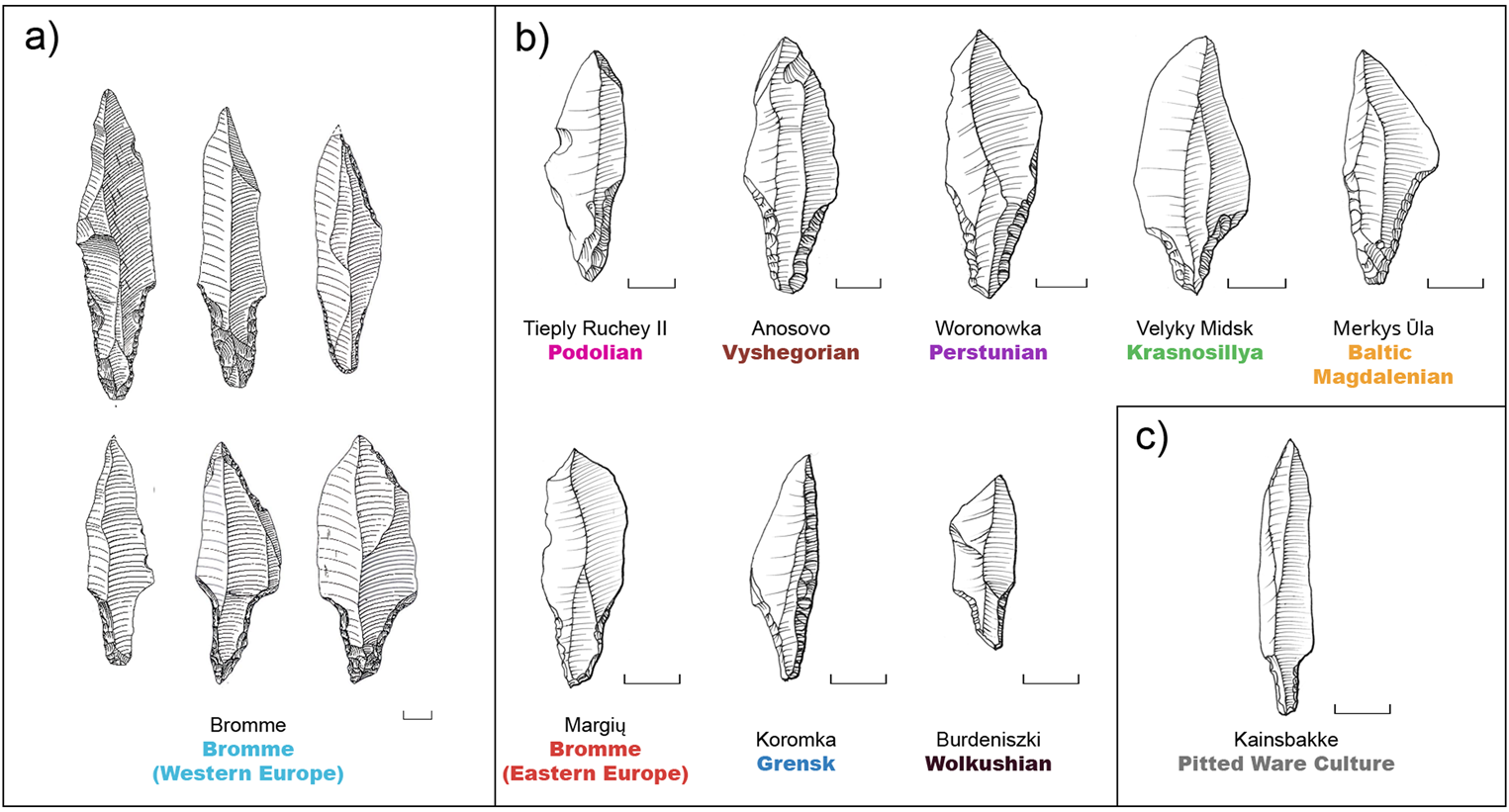
In eastern Europe, Wyszomirska-Webert (Reference Wyszomirska-Webert1996: 97) viewed the plethora of cultural units with a critical eye, enquiring into the ontological and epistemological robusticity as well as the anthropological meaning of ‘all these fantastic cultures’ that, according to the then-prevalent view, populated the region in prehistory. As a subset of these, the Late Palaeolithic is made up of several large tanged point cultures, each with a rich and mixed research history. The iconic large tanged point forms, in all its diversity (Figure 1), the basis of cultural classifications. Today, the proposed cultural geography for this period is characterized by substantial taxonomic diversity (Table 1). These groups are traditionally used to infer processes of ‘palaeohistory’ (sensu Kozłowski & Kozłowski, Reference Kozłowski and Kozłowski1979): the territories, collective actions, and migrations of identity-conscious ethnic groups (Figure 2).
Examples of tanged points from eastern Europe. a) Examples from the type site of Bromme (Denmark). b) Archaeological units in eastern Europe featuring tanged points. c) Examples of tanged points from the Pitted Ware site of Kainsbakke (Denmark). Scale: 10mm. The colour palette corresponds to the visualization used throughout this article. Illustrations: Bromme (Redrawn after Taute, Reference Taute1968; Fig. 95: 2, 3, 4, 7, 8, 10), Tieply Ruchey II (Sorokin, Reference Sorokin, Sorokin, Oshibkina and Trusov2009; Fig. 3:1), Anosovo (Zaliznyak, Reference Zaliznyak1999; Fig. 31: 2), Woronowka (Redrawn after Szymczak, Reference Szymczak1991; Fig. 18:1), Velyky Midsk (Redrawn after Zaliznyak, Reference Zaliznyak1999; Fig. 12:3), Merkys-Ūla (Redrawn after Rimantienė, Reference Rimantienė1971; Fig. 19:5), Margių (Redrawn after Rimantienė, Reference Rimantienė1999: Fig. 19:13), Koromka (Redrawn after Zaliznyak, Reference Zaliznyak1999; Fig. 28:29), Burdeniszki (Redrawn after Szymczak, Reference Szymczak1995; Fig. 6:2), Kainsbakke (Redrawn after Rasmussen & Richter, Reference Rasmussen and Richter1991; Fig. 21:2).

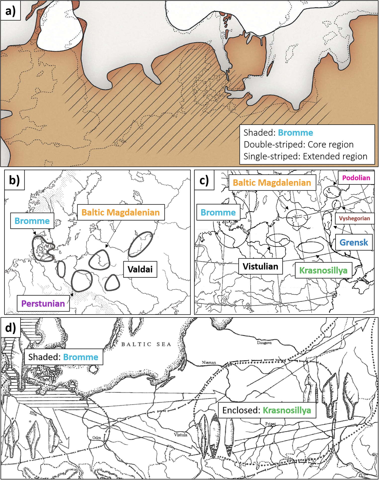
Maps showing the proposed tanged point cultures of north-eastern Europe, from (a) Andersson et al. (Reference Andersson, Karsten, Knarrström and Svensson2004), (b) Kozłowski (Reference Kozłowski, Kozłowski, Gurba and Zaliznyak1999), (c) Sinitsyna (Reference Sinitsyna2002), and (d) Zaliznyak (Reference Zaliznyak1999). The colour palette for cultures corresponds to the visualization used throughout this article. Note how the variable taxonomy and the different authors’ predilections for splitting or lumping create substantially different cartographic expressions. Common to all these maps is that the relationship between the proposed ‘territories’ of these large tanged point groups and the evidence on which these are based remains opaque.
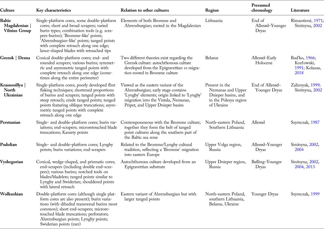
Eastern European tanged point cultures, their characteristics and key references.

As elsewhere, these projectile points are invested with chronological, spatial, and, by extension, cultural specificity (O'Brien & Lyman, Reference O'Brien and Lyman1999). Otte & Keeley (Reference Otte and Keeley1990) have noted, however, that taxonomic units in this period are usually based on early antiquarian excavations of but a few key sites, reflected in the practice of naming them after these loci classici; they also point out that ‘explanations offered for the events in such sequences, whether explicit or implicit, tend to focus on local phenomena or events and reinforce ideas of local continuity and evolution’ (Otte & Keeley, Reference Otte and Keeley1990: 577). A more acerbic critique has been voiced by Houtsma and collegues, who argued that ‘[o]nly when researchers of the Late Palaeolithic habitation of the Northwest European Plain escape the constraints of contemporary national borders and the paradigmatic straight-jackets of provincialism and regional chauvinism, which lead to insularity, will we be in a position to gain analytical control of the totality of extant data partitioned into uniform and mutually comparable sets of demonstrably relevant attributes’ (Houtsma et al., Reference Houtsma, Kramer, Newell and Smit1996: 143). Their critique is arguably as valid for the eastern extension of the North European Plain as it is for its western end. Most radically, Clark and Lindly (Reference Clark and Lindly1991) have argued that this entire way of thinking in terms of archaeological cultures supposedly reflecting past peoples, their actions, adaptations, and migrations is flawed at the paradigmatic level.
In order to bring some clarity to this situation, we present a review of the research history of the Late Palaeolithic large tanged point cultures in eastern Europe. Following Sauer and Riede (Reference Sauer and Riede2019), such source-critical interrogations provide evaluations of the epistemic status of the units in question. We find many units problematic in this regard and, using geometric morphometric (GMM) approaches, we offer an alternative way of capturing tanged point variability across the region without abstraction from the evidence base.
Research History and Current Late Palaeolithic Cultural Taxonomies: Splitters vs Lumpers
In the European Late Palaeolithic, we encounter the lumper–splitter conundrum, well-known from any discipline concerned with classification (see Simpson, Reference Simpson1945; Adams & Adams, Reference Adams and Adams1991): some researchers tend towards lumping assemblages into higher-level units, while others split them in order to distinguish industries, cultures, or facies according to, for instance, local manufacturing traditions or different economic strategies. There are, however, no recognized standards for such classification in archaeology.
Practitioners working within the Palaeolithic archaeological traditions of central and eastern Europe tend to exhibit a strong preference for splitting. Perceived differences between assemblages with large tanged points found in different regions or even in individual river valleys are commonly emphasized. This predilection may stem from the need to organize large quantities of archaeological material from several different countries (e.g. Poland, Lithuania, Russia, Belarus, and Ukraine), coupled with strong regional identities and the, implicit or explicit, motivation to stress differences rather than similarities between regions. Hence, a plethora of cultures considered taxonomically comparable to the Scandinavian Bromme culture are found in eastern Europe, although the criteria for distinguishing these units often remain ambiguous (Table 1).
The explanations for the presence of tanged points in eastern Europe can be divided into three schools:
• direct migration/expansion of the Bromme culture
• cultural contact/diffusion of point forms through borrowing, or
• one or several independent innovations converging on the same form of projectile point.
In Polish Late Palaeolithic archaeology, two particular units are seen as similar to the Brommean in terms of chronology and lithics: the Perstunian (Szymczak, Reference Szymczak1991) and Wolkushian cultures (Szymczak, Reference Szymczak1995). Szymczak (Reference Szymczak1983, Reference Szymczak, Burdukiewicz and Kobusiewicz1987, Reference Szymczak1990) distinguished the Perstunian on the basis of six homogeneous sites found in north-eastern Poland and southern Lithuania (Szymczak, Reference Szymczak1991), but was met with harsh source-critical scepticism at the time (Sulgostowska, Reference Sulgostowska1989).
The Perstunian is explicitly framed as analogous to the Bromme culture in terms of dating and diagnostic tool forms. The Perstunian lithic inventory consists of conical cores, burins, scrapers, and large tanged points, with its origin in the Allerød chronozone. In the absence of absolute dates and meaningful stratigraphies, however, this dating remains a hypothesis grounded in the observation that Perstunian artefacts are typically in worse condition than Swiderian artefacts and the rationale that the eastern European Perstunian assemblages and more westerly inventories of the Bromme culture are generally similar in terms of typology and technology (Szymczak, Reference Szymczak1992, Reference Szymczak1995). According to Szymczak (Reference Szymczak1991), the differences between the Perstunian and Brommean are the appearance of double-platform cores, a higher frequency of burins, and the appearance of the so-called Kaszety point. Despite the early critique highlighting the weak empirical basis for the Perstunian, this culture has found its way into current literature with sites both in Poland and elsewhere being attributed to it (Siemaszko, Reference Siemaszko1999a, Reference Siemaszko, Kozłowski, Gurba and Zaliznyak1999b; Sinitsyna, Reference Sinitsyna2002).
Likewise, Szymczak also identified the Wolkushian as a separate cultural unit (Szymczak, Reference Szymczak1995). The territory of the Wolkushian overlaps with that of the Perstunian, as artefacts of both units are found at the same sites (Szymczak, Reference Szymczak1995). Wolkushian lithic tool forms are also similar to the Perstunian with single- and double-platform blade cores, and varying forms of scrapers, burins, and tanged points. For Szymczak (Reference Szymczak1995), the distinctive features of the Wolkushian include: a high frequency of double-platform cores, large core-like burins, large tanged points including forms with flat ventral retouch reminiscent of the Swiderian, large tanged points with no ventral retouch analogous to Brommean points, and smaller tanged points lacking any modifications of the ventral surface similar to Ahrensburgian points (Szymczak, Reference Szymczak1995). Wolkushian elements have so far been recognized at nine sites—some seemingly homogenous, some mixed—from north-eastern Poland.
Further to the east, a suite of geographically tightly circumscribed cultures distinguished by large tanged points have been proposed. These are: 1) the Baltic Magdalenian/Vilnius group; 2) the Grensk culture; 3) the Krasnosillya/North Ukrainian group; 4) the Podolian; and 5) the Vyshegorian.
In Lithuania, the Baltic Magdalenian culture was first defined by Rimantienė (Reference Rimantienė1971), who argued that it stemmed from the same Late Magdalenian origin as the Brommean. The tools characterizing this culture are single- and double-platform cores, various tanged point forms, short and broad scrapers, burins of different types, and combination tools. Smaller tanged points, it was argued, are the main difference between the Baltic Magdalenian and the Brommean, which in turn implied a slightly later date for the Lithuanian Late Palaeolithic (Rimantienė, Reference Rimantienė1971). Later, this culture was rejected by some Lithuanian scholars and replaced with a classification that split the same material (Šatavičius, Reference Šatavičius, Zabiela, Baubonis and Marcinkeviciute2016). A recent review of the evidence has failed to find support for such detailed splitting (Ivanovaitė & Riede, Reference Ivanovaitė and Riede2018).
In Belarus, many Late Palaeolithic tanged point assemblages are attributed to the Grensk culture first defined by Bud'ko (Reference Bud'ko1966) and argued to reflect a local development from eastern Epigravettian traditions. Later, a migration-based theory suggested the introduction of the Bromme/Lyngby culture as the source of this regional development (Zaliznyak, Reference Zaliznyak1999). These two explanations continue to exist as the favoured, albeit opposing, hypotheses for the origin of the Grensk phenomenon (see Kolasau, Reference Kolasau2018). Typical Grensk assemblages consist of single-platform and double-platform cores, although other (multiple platform and discoidal) forms are also found; various forms of scraper occur, as do truncated, dihedral, angle, and combination burins, notched tools, borers, flakes with obliquely retouched truncation, backed blades, and chopping tools. Tanged points and specifically asymmetrical points termed the ‘Grensk type’ characterize the eponymous assemblages (Kolasau, Reference Kolasau2018).
In the Polesia region of Ukraine, the Krasnosillya culture was first distinguished by Zaliznyak (Reference Zaliznyak1999), one of the main advocates of Bromme/Lyngby migrations from Scandinavia to eastern Europe. To him, this migration was the source for all eastern European tanged point cultures. A typical trait of Krasnosillya lithic technology is its low tool-blank selectivity. Tools are mainly formed by intensive retouching of ad hoc blanks rather than standardized blades (Zaliznyak, Reference Zaliznyak1999). These assemblages comprise mainly single-platform cores, in addition to burins and tanged points of variable size (Zaliznyak, Reference Zaliznyak1999).
In Russia, two pertinent archaeological cultures are identified, the Podolian of the Upper Volga region and the Vyshegorian of the Upper Dnieper Basin, with both autochthonous and migration theories proposed to understand them (Sinitsyna, Reference Sinitsyna2002, Reference Sinitsyna, Crombé and Vermeersch2004). The Podolian is viewed as a Brommean analogue resulting from earlier dispersals (Sinitsyna, Reference Sinitsyna2002, Reference Sinitsyna, Crombé and Vermeersch2004). Characteristic lithics include single- and double-platform cores, large tanged points, burins made from broken tanged points, various scrapers, and axes produced from flakes. The Vyshegorian, in contrast, represents an autochthonous development from the Epigravettian (Sinitsyna, Reference Sinitsyna and Sinitsyna2013). Typical assemblages include conical, wedge-shaped single- and double-platform prismatic cores, tanged and shouldered points with lateral retouch, various burin types, scrapers, notched tools, and axes (Sinitsyna, Reference Sinitsyna2002, Reference Sinitsyna, Crombé and Vermeersch2004). Like most Late Palaeolithic cultures in eastern Europe, these two cultures are poorly defined chronologically. While the Podolian is dated to the Allerød/Younger Dryas through typological and geological inference, a single relevant radiocarbon date (LE-5029) places it at 9180 ± 75 bp (Sinitsyna, Reference Sinitsyna, Crombé and Vermeersch2004). Calibrated with OxCal 4.3 (Bronk Ramsey, Reference Bronk Ramsey2009) and using the IntCal 13 calibration curve (Reimer et al., Reference Reimer, Bard, Bayliss, Beck, Blackwell and Bronk Ramsey2013), this yields an early Holocene date of 10,550–10,220 cal bp.
Kobusiewicz (Reference Kobusiewicz, Street, Barton and Terberger2009a, Reference Kobusiewicz2009b) has argued that the various proposed eastern European cultures identified in the basis of large tanged points are epistemologically weak because:
1. these cultures are often based on limited material derived from poorly constrained assemblages
2. large tanged points most commonly occur with other elements (e.g. arch-backed points, small tanged points) argued to be indicative of other cultures
3. the size of the proposed territories does not correspond to meaningful territorial sizes observed in the ethnographic record (see Sauer & Riede, Reference Sauer and Riede2019), and
4. the argued differences in the shape of the diagnostic artefacts are too slight.
Following up on this critique, Sauer and Riede (Reference Sauer and Riede2019) have also shown that artefact frequencies, used in the Bordian tradition as a cultural designator (see Salomonsson, Reference Salomonsson1964; Kozłowski & Kozłowski, Reference Kozłowski and Kozłowski1979), do not yield meaningful results, especially when formal types are few and ambiguous and assemblages are most commonly derived from surface collections. Contemporaneous osseous artefacts or other non-lithic elements are exceedingly rare and hence play a very limited role in cultural taxonomy, leaving the supposedly diagnostic projectile point forms as the foundation of contemporary cultural taxonomies. All this makes it a pressing matter to examine the large tanged points of eastern Europe, with the aim of revealing shape variations that are structured temporally and/or spatially. In the following, we build on earlier GMM analyses of tanged points in northern Europe (Serwatka & Riede, Reference Serwatka and Riede2016; Serwatka, Reference Serwatka2018), but with a specific focus on eastern Europe and with a particular aim to uncover, if possible, meaningful hierarchical structure within this key artefact class.
Materials and Methods
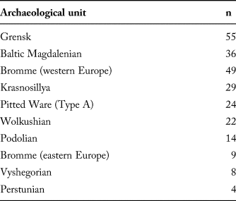
To investigate the appropriateness of the current nomenclature used throughout the Late Palaeolithic of eastern Europe, a two-dimensional GMM methodology is used here, drawing on illustrations of 177 complete tanged points from seventy-two archaeological contexts, distributed across sixty-one sites. Examples come from Poland, Belarus, Lithuania, western Russia, and Ukraine (Figure 3), and include cultural taxonomic attributions to the Baltic Magdalenian, Bromme, Grensk, Krasnosillya, Perstunian, Podolian, Vyshegorian, and Wolkushian units. This is complemented by examples of the Bromme culture from western Europe (n = 49), including specimens from the eponymous Bromme site (Mathiassen, Reference Mathiassen1946), and, as a control group, mid-Holocene ‘Type A’ large tanged points from the Pitted Ware culture (n = 24) which infamously resemble Late Palaeolithic specimens (Fischer, Reference Fischer and Kristiansen1985). Therefore, a total of 250 lithic illustrations were examined (Table 2). We are aware that the size of this sample is limited, but it does reflect the truly limited selection of artefacts on which some of the cultural taxonomic units are based and the fact that we restricted our sample to complete specimens. While any statistical approach should work with as large a sample size as possible, we note that the use of lithic drawings, as presented by their authors, does allow testing of cultural taxonomic assessments because complete and supposedly typical or ideal specimens are usually selected for drawing with the strong epistemic implication that they are representative of taxonomic entities in general (see Lopes, Reference Lopes2009). One implication of this original selection bias inherent in the literature is that our analysis probably addresses merely a fraction of the actual lithic variability found in the Late Palaeolithic in the region, but stands as a direct cultural taxonomic test vis-a-vis the existing corpus of literature.
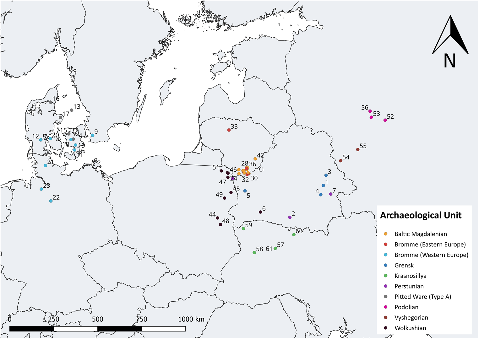
Map of all sites examined in this study. 1) Baroŭka; 2) Chilczyce; 3) Chvojnaja; 4) Koromka; 5) Krasnasieĺski; 6) Motol; 7) Woronowka; 8) Elemly Sø; 9) Hjarup Mose; 10) Rolykkevej; 11) Rundebakke; 12) Sølystgaard; 13) Anholt; 14) Søtofte; 15) Føllenslev; 16) Smedegaarde; 17) Kainsbakke; 18) Bromme; 19) Trollesgave; 20) Bro; 21) Alt Duvenstedt; 22) Dohnsen; 23) Sassenholz; 24) Baltašiškės; 25) Derežnyčia; 26) Duba; 27) Ežerynas; 28) Glūkas; 29) Glyno Pelkė; 30) Gribaša; 31) Kašėtos; 32) Katra; 33) Lieporiai; 34) Marcinkonys; 35) Margių; 36) Maskauka; 37) Merkys-Ūla; 38) Mitriškės; 39) Rudnia; 40) Varėna; 41) Varėnė; 42) Vilnius; 43) Burdeniszki: 44) Dziewule-Piaski; 45) Krzemienne; 46) Maćkowa Ruda; 47) Płaska; 48) Stańkowicze; 49) Suraż; 50) Wolkusz; 51) Zusno; 52) Podol; 53) Ust-Tudovka; 54) Anosovo; 55) Vishegore; 56) Tieply Ruchey; 57) Krasnosillya; 58) Lipa; 59) Liutka; 60) Rudnya; 61) Velyky Midsk.
Dataset used in this study (n = 250).

To examine shape variation among these specimens and taxonomic units, elliptic Fourier analysis (EFA) was used. EFA is a method of closed-outline shape analysis grounded on the decomposition of closed outlines (produced through the creation of semi-landmarks) into an infinite series of repeating trigonometric functions (harmonics; see Caple et al., Reference Caple, Byrd and Stephan2017). EFA has the advantage of not requiring data points to be equal in number, or evenly spaced, allowing more closely-spaced data points on segments of high curvature and artefact complexity (Rohlf & Archie, Reference Rohlf and Archie1984; Crampton, Reference Crampton1995). EFA is now commonplace in the exploratory and statistical analysis of archaeological stone tool shapes (Gero & Mazzullo, Reference Gero and Mazzullo1984; Saragusti et al., Reference Saragusti, Karasik, Sharon and Smilansky2005; Iovita, Reference Iovita2009, Reference Iovita, Lycett and Chauhan2010; Serwatka, Reference Serwatka2015; Iovita et al., Reference Iovita, Tuvi-Arad, Moncel, Despriée, Voinchet and Bahain2017).
All illustrations (.png) were first synthesized into one thin-plate spline (.tps) file, a common file format for GMM analyses. This was carried out in tpsUtil v.1.69. Cartesian coordinates and positions for each image were created using the ‘Outline object’ function in tpsDig2 v.2.27 and pixel noise eliminated in tpsDig2 (Rohlf, Reference Rohlf2015). As these outlines do not require the same number of landmarks, and in order to capture as much of the original shape as possible, the raw outline was retained (Figure 4). Thus, the tanged point specimens feature an average of 1544 Cartesian coordinates. In standardizing all outlines prior to EFA, all specimens were normalized to a common centroid (0,0) and rescaled using their centroid size as suggested by Bonhomme et al. (Reference Bonhomme, Forster, Wallace, Stillman, Charles and Jones2017). Normalization through rotation was unnecessary as this is incorporated through subsequent elliptic fitting. In selecting an appropriate number of harmonics necessary to capture tanged point shape (here defined as 99.9 per cent harmonic power), the ‘calibrate_harmonicpower_efourier’ function, supported by the ‘calibrate_reconstructions_efourier’ and ‘calibrate_deviations_efourier’ functions in Momocs v.1.2.9 (Bonhomme et al., Reference Bonhomme, Picq, Gaucherel and Claude2014) were used. For 99 per cent harmonic power, eleven harmonics were retained.
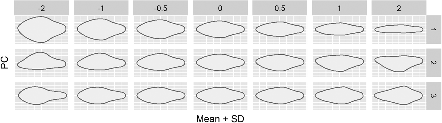
XY transformations for the first three principal components (82.1 per cent cumulative shape variance).

To assess the robustness and structure of the current taxonomy, the elliptic Fourier descriptors were first subjected to exploratory principal components analysis (EFA-PCA), an ordination-based method for exploring the underlying shape structure within a GMM dataset. In visualizing differences and similarities among different archaeological units, 66 per cent confidence ellipses are employed. The contributions of each major principal axis were examined through a scree plot, along with the specific XY shape transformations and configurations. Discrimination-based analyses were not undertaken as a number of groups do not meet suggested sample size values and as our a priori confidence in the groups’ validity is low, given the research-historical and epistemic concerns outlined above. Such concerns make discriminant analyses unsuitable as a test of taxonomic validity (Klecka, Reference Klecka1980; McGarigal et al., Reference McGarigal, Stafford and Cushman2000; Kovarovic et al., Reference Kovarovic, Aielo, Cardini and Lockwood2011). To explore tanged point variation between different archaeological units through a statistical framework, a multivariate analysis of variance (MANOVA), through a Hotelling–Lawley, of 99 per cent cumulative shape variance (the first twenty-one principal components) was carried out. If significant, pairwise testing (through a Pillai Trace) is employed to understand the relationship between specific archaeological units. Statistical significance is defined here by an alpha level of 0.01, with a null hypothesis of no difference between taxonomic units.
Finally, to better understand the underlying structure and degree of similarity among archaeological units, agglomerative hierarchical cluster analysis was adopted. Agglomerative hierarchical clustering works on dissimilarity matrices and builds a hierarchical structure from individual shapes by progressively merging clusters (Shennan, Reference Shennan1997; Claude, Reference Claude2008). Here, agglomerative hierarchical clustering (complete linking) is employed to visualize, quantify, and hence qualify the degree of dissimilarity between all artefacts in relation to their proposed archaeological unit membership. A dendrogram using the first twenty-two principal components and a Euclidean distance measure is employed here.
All analyses were carried out in Momocs v.1.2.9 (Bonhomme et al., Reference Bonhomme, Picq, Gaucherel and Claude2014) for the R Environment (R Development Core Team, 2017). Complementary R packages including tidyverse v.1.2.1 (https://cran.r-project.org/web/packages/tidyverse/index.html and ggtree v.10.5, Yu et al., Reference Yu, Smith, Zhu, Guan and Tsan-Yuk Lam2017) were used for data visualization and transformation. The Open Science guidelines from Marwick (Reference Marwick2017) were followed and the .tps file, the metadata, and annotated R script can be found on the Open Science Framework (https://osf.io/agrwb/). All associated code, data, and figures can also be found on GitHub: https://github.com/CSHoggard/-Eastern-Europe-Tanged-Points.
Results
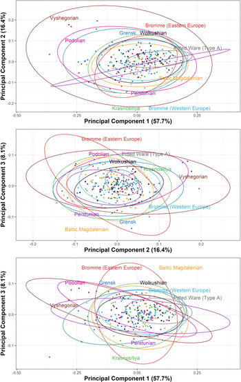
An examination of tanged point outline shape through EFA-PCA reveals that the first three principal components feature greater than 5 per cent shape variance, and total 82.1 per cent cumulative shape variance. The first principal component (57.7 per cent shape variance) ranges from tanged points with narrow tangs, shoulders, and blade edges to wider forms, whereas the second principal component (16.4 per cent shape variance) represents an asymmetric transformation, specifically the positioning of the shoulder or blade edge with the greatest convexity. The third principal component (8.0 per cent shape variance) extends from elongated to short and wider tang forms. For a visual guide to these first three principal components see Figure 4, and for further information on the transformations of subsequent principal components please refer to the R script noted above (https://osf.io/agrwb/).
When the shape variation is explored through the different archaeological units, the PCA analysis (Figure 5) highlights the difficulty in classifying certain archaeological units by tanged point shape, and, conversely, in distinguishing between specific units. In the first principal component, Podolian, Grensk, and Vyshegorian groups occupy a similar morphospace (their confidence ellipses overlap) with negative PC1 scores indicative of wider tanged forms. In contrast, Pitted Ware examples have the greatest proportion of positive PC1 scores indicative of slender tanged forms, to an extent where there is little overlap with other archaeological units. In the graph centroid (shapes more typical of the mean), several overlapping units can be observed, including the Wolkushian, Bromme (both regions), Krasnosillya, and Baltic Magdalenian. This overlap largely continues into the second principal component, with these same units overlapping.
Principal component analysis of Fourier coefficients calculated for Late Palaeolithic tanged points in eastern Europe. Top: PC1 and PC2 (74.1 per cent cumulative variance). Middle: PC2 and PC3 (24.46 per cent cumulative variance). Bottom: PC1 and PC3 (66.3 per cent cumulative variance).
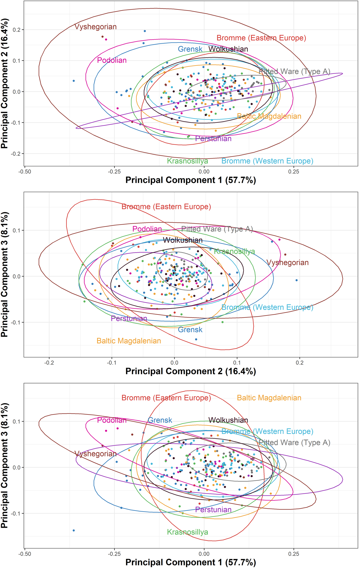
Regarding the second and third principal components, considerably greater variation is exhibited in many of the archaeological units, with the Perstunian and Pitted Ware examples most strongly constrained. As the second principal component represents asymmetric variation in the accentuation of the tang, dorsal/ventral siding may help explain this great variation. The first and third principal components may better represent the actual variation exhibited by the archaeological units, as these represent symmetric changes in tanged point shape. However, the distribution of artefacts in this plot largely mirrors the first plot, with a distinct Pitted Ware cluster, similarities in Podolian, Vyshegorian, and Grensk forms, and a mixture of units in the graph centroid.
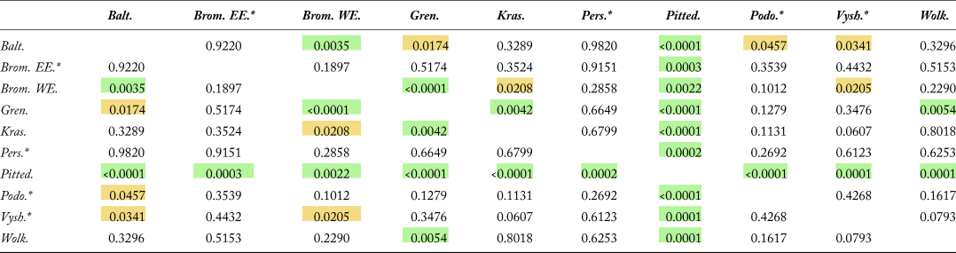
With 99 per cent cumulative shape variance, a MANOVA was carried out and highlighted statistical significance to the desired 0.01 alpha level (Hotelling-Lawley: 1.7604, F: 2.0326, p: < 0.0001), demonstrating difference in artefact shape among all tanged points. Given the significance of the overall test, further tests for pairwise differences were undertaken (Table 3). In this, differences can be observed, specifically differences between: 1) Pitted Ware (Type A) and all other taxonomic units; 2) the Baltic Magdalenian and Bromme (western European) units; 3) the Grensk and Bromme (western European) units; 4) the Grensk and Krasnosillya units; and 5) the Grensk and Wolkushian units. Interestingly, no statistical difference was observed between the two Bromme units (Pillai Trace: 0.1073, F: 1.5931, p: 0.1897), indicating no difference in artefact shape; no difference between Bromme examples in eastern Europe and any other eastern European unit was also detected (see Table 3). The consistently identified difference between the putative Late Glacial cultural units identified by large tanged points and the much later Pitted Ware culture points is notable and encouraging. Pitted Ware culture points tend to be more symmetric than Late Palaeolithic specimens (Dev & Riede, Reference Dev and Riede2012) and are more likely to have been arrowheads (Bye-Jensen, Reference Bye-Jensen2011), whereas earlier large tanged points are more probably dart-points (Riede, Reference Riede2009). The ballistic form and size constraints on dart-heads are somewhat laxer compared to arrowheads (see Shott, Reference Shott1997) and this appears to be reflected in the consistently narrow shape of our Pitted Ware specimens.
Pairwise MANOVA for examined archaeological units. Green: 0.01 significance level; yellow: 0.05 significance level; *small sample size (n ≤20).

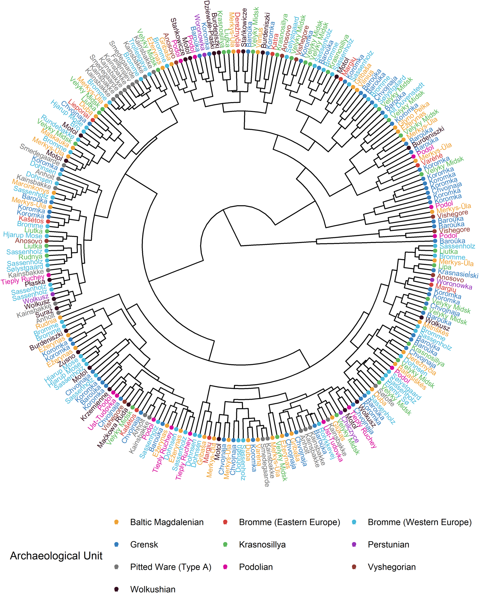
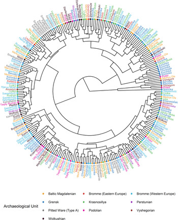
A hierarchical cluster analysis of all individual tanged points (Figure 6) indicates that very few of the artefacts assigned to the different archaeological units demonstrate consistent grouping. Some sites show minor clustering, such as Koromka (artefact IDs 63–68), perhaps indicative of locally or individually shared behaviour. Yet, on a higher branch level, no clustering consistent with traditional cultural taxonomic units is observed. The sole exception is the Pitted Ware culture (Type A), with the majority of specimens clustering within one or two clades, further highlighting the degree of standardization in this specific tanged point.
Hierarchical agglomerative clustering (complete linkage) of all tanged point outlines (n = 250) and their associated taxonomic unit (IDs correspond to the dataset associated with this article).
Discussion
Ethnographic observations of group identity encoded in lithic projectile points (e.g. Wiessner, Reference Wiessner1983; Sinopoli, Reference Sinopoli, Miracle, Fisher and Brown1991) are often cited as the core rationale for grounding Palaeolithic cultural taxonomies on this artefact. In the Late Palaeolithic of Europe, projectile points are also, implicitly or explicitly, taken to be the primary artefact class defining cultural groupings. Yet, our investigations into research history and the GMM analyses reported here indicate that existing classifications of the Late Palaeolithic cultures anchored in lithic projectile point forms in north-eastern Europe at least are not robust. It appears that there are no consistent differences in projectile point shape between the various cultures as currently proposed. In sum, the diverse and highly variable morphologies of large tanged projectile points found in the region prevents any robust classification of this material and hence makes building larger-scale cultural taxonomies difficult—at least those that aim to distinguish regionally or locally circumscribed units on the basis of lithic projectile points.
The general simplicity of form and similarity of Late Palaeolithic tanged points makes it hard to draw any conclusions about intercultural diversity based on this artefact class alone. Notably, simplicity and variability also characterize other aspects of Late Palaeolithic lithic technology, which is straightforward and generic, relying on raw materials of variable quality and rather ad hoc core exploitation strategies, both in the western (Fischer, Reference Fischer, Barton, Roberts and Roe1991: 116; Barton, Reference Barton1992: 192; Madsen, Reference Madsen, Holm and Rieck1992: 128; Johansen, Reference Johansen, Valentin, Bodu and Christiensen2000: 22) and eastern parts of northern Europe (Rimantienė, Reference Rimantienė1971; Szymczak, Reference Szymczak1991, Reference Szymczak1995; Sinitsyna, Reference Sinitsyna2002). Although we did not analyse other tool, blade, or core forms at the same level of detail, our review of these elements commonly used as classificatory auxiliaries also shows substantial overlap between units.
Whether this overall similarity in Late Palaeolithic technology and artefact shapes is primarily caused by shared ancestry or whether it suggests a substantial degree of convergent technological evolution (O'Brien et al., Reference O'Brien, Buchanan and Eren2018) remains to be investigated in greater detail. Recent genomic studies are revising migrantionist theories. Villalba-Mouco et al. (Reference Villalba-Mouco, van de Loosdrecht, Posth, Mora, Martinez-Moreno and Rojo-Guerra2019), for instance, suggest that, by 15,000 years ago, hunter-gatherers of distinctly different ancestry admixed with and replaced groups associated with the Magdalenian in parts of Europe. While this can be interpreted to indicate that Magdalenian foragers did not reach eastern Europe, as suggested by Rimantienė (Reference Rimantienė1971), and that the Late Palaeolithic colonization of eastern Europe should instead be associated with the Epigravettian, as suggested by Bud'ko (Reference Bud'ko1966), the logic of linking culturally defined groups with genetic clusters itself needs urgent attention (see Riede et al., Reference Riede, Hoggard and Shennan2019). The absence of secure radiocarbon dates associated with eastern European tanged point assemblages, as well as the paucity of organic remains including human remains suitable for genomic interrogration, make the matter more complicated by not allowing a secure placement of these assemblages in the wider chronological context of the Late Palaeolithic.
It is our worry that the school of thought that links ethnicity with prehistoric culture history—shown to be prevailing in eastern Europe (Barford, Reference Barford1996; Wyszomirska-Webert, Reference Wyszomirska-Webert1996)—has been driving the profligate definition of Late Palaeolithic cultures; yet they cannot readily be discriminated in a quantitative, inter-regional perspective. Much like the Levantine Epipalaeolithic, Late Palaeolithic Europe may thus be largely populated by ‘phantom cultures’ (Barton & Neeley, Reference Barton and Neeley1996: 139).
Conclusion
Cultural taxonomy is as essential to archaeological enquiry as it is unfashionable. For most periods of the European Palaeolithic, multiple and sometimes competing cultural taxonomic schemata have been proposed, usually with reference to key artefact classes such as projectile points. Our current taxonomies have accumulated over long periods of changing theoretical, conceptual, and methodological paradigms and in tandem with broader socio-political changes. Most workers are aware of such caveats, yet culturally-laden typological designations are frequently used in archaeological research and heritage management alike, reinforcing the impression of strong regional distinctiveness in the archaeological record (see Barford, Reference Barford1996; Riede, Reference Riede, Sørensen and Buck Pedersen2017). The Late Palaeolithic of eastern Europe is no exception, but our critical investigation into research history and novel analyses of tanged point shapes have shown that many currently defined regional groupings are not as diagnostically distinct as previously proposed.
In our analysis, we have focused exclusively on large tanged points. Naturally, other aspects of material culture may allow us to better discriminate between cultural units. In particular, lithic reduction techniques, as analysed through operational chains, have been proposed as a key method (e.g. Damlien et al., Reference Damlien, Berg-Hansen, Zagorska, Kalniņš, Nielsen and Koxvold2018). Problematically, however, such time-consuming analyses usually begin by selecting assemblages that are pre-classified by traditional typological means (mostly through projectile points) and hence tend to replicate traditional taxonomies. Furthermore, limited sample sizes and as yet unexamined degrees of inter-observer variability speak against operational chain analysis as necessarily a better way of resolving cultural taxonomic questions. Most probably, a judicious combination of qualitative and quantitative methods will provide the hoped-for solution, although available methodologies (e.g. Tostevin, Reference Tostevin2013) have yet to be applied to the Late Palaeolithic of Europe. By this token, our analysis should be understood as a new parsimonious lumping hypothesis to be tested against alternative definitions using similarly transparent, data-driven approaches.
Nonetheless, it is critical that we clarify these issues and begin to build more robust cultural taxonomies as both palaeoenvironmental scientists and geneticists are increasingly looking to explain Late Pleistocene human demographic processes—and they tend to incorporate archaeologically defined units under the reasonable assumption that these are robust and can be understood as proxies for past populations (see Riede et al., Reference Riede, Hoggard and Shennan2019). While we strongly welcome the ambitions and intentions behind such novel bio-cultural approaches, we caution equally strongly against uncritically deploying the cultural taxonomic units of the northern European Late Palaeolithic as they are currently defined. New methods, such as geometric morphometrics, coupled with, for instance, cultural phylogenetics are offering innovative ways to construct archaeological taxonomies. Such cultural phylogenies represent hypotheses of historical patterns and processes (see O'Brien et al., Reference O'Brien, Lyman, Collard, Holden, Gray, Shennan and O'Brien2008). They can be used to discriminate between divergent and convergent cultural evolution, and they offer ways of more formally and transparently defining nested cultural taxonomies. Future research should seek to include as wide a range of material culture information as possible. The ever-increasing availability of literature is facilitating such comparative approaches, yet barriers to inter-regional integration persist. Aligning and opening archaeological datasets across research traditions, as we have attempted here, is a prerequisite for overhauling integrative comparative approaches.
Acknowledgments
Livija Ivanovaitė, Christian Hoggard, Florian Sauer, and Felix Riede were supported by grant #6107-00059B awarded to Felix Riede by the Independent Research Fund Denmark. Kamil Serwatka was supported by the Aarhus University Research Foundation. Felix Riede also gratefully acknowledges funding from the European Research Council (grant agreement 817564 under the Horizon 2020 research and innovation programme). Finally, the authors would like to thank the three anonymous reviewers for their valuable comments and the EJA editorial team's attention to detail.


 Open access