Introduction
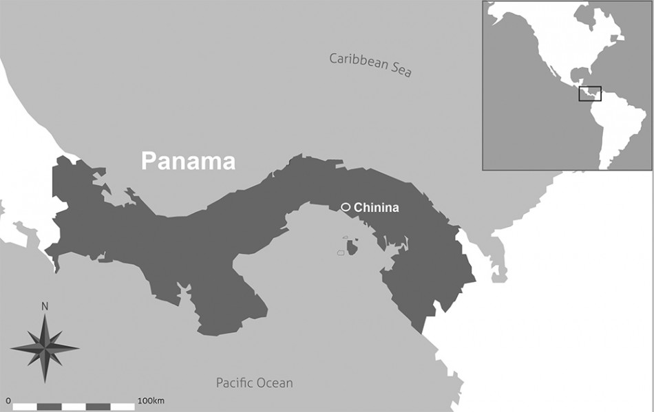
Map of Panamá and Chinina’s location.

Aerial photography has been recognised as an invaluable tool for archaeological prospection for nearly a century. In recent years, however, it has gained increasing importance for two reasons: the availability of high quality aerial photographs via the Internet has facilitated archaeological surveys in even remote areas; and, archaeological perspectives on past human societies have changed—modern ecological problems have stimulated increasing interest in landscape archaeology. In this paper, we report the identification by Rainer Schreg of the first evidence for fossil field structures in Chinina, eastern Panamá, using online aerial photographs. This discovery was a result of a systematic search inspired by a previous project dealing with the colonial period that raised questions about regional landscape dynamics (Figure 1).
In Panamá, palaeoecological studies were first carried out by Dolores Piperno and her team in the 1980s (Reference PipernoPiperno 1985, 1994). The results of this research contributed to the knowledge of agricultural development in Central America and, in particular, the manipulation and domestication of plants. Despite the importance of the Panamanian data for a wider discussion of the development of agriculture in tropical environments, there has been no work on agricultural practice and land use patterns in the country.
Across South America, raised fields have been documented in several regions. They are well known in Colombia (Reference ParsonsParsons 1966; Reference BroadbentBroadbent 1968; Plazas & Falchetti 1981; Reference Plazas and FalchettiPlazas et al. 1993), Ecuador (Reference ParsonsParsons 1969; Bouchard & Usselmann 2006; Reference GondardGondard 2006; Reference MarcosMarcos 1987), Perú (Reference Pozorski and PozorskiPozorski et al. 1983), Bolivia (Reference DenevanDenevan 1963, 2001; Reference SmithSmith et al. 1968; Reference EricksonErickson 1995, 1996), Venezuela (Zucchi & Denevan 1979; Gassón & Rey 2006) and Surinam (Reference Iriarte, Glaser, Watling, Wainwright, Birk and RenardIriarte et al. 2010, 2012; Reference Mckey, Rostain, Iriarte, Glaser and BirkMcKey et al. 2010). They have been documented in various climatic regions from the Andes to the Caribbean coast (Reference DenevanDenevan 2001; Reference RostainRostain 2008), and there may have been several reasons for people to construct these types of fields: they mitigate high water levels in floodplains and control water drainage; they enrich the soil with fresh nutrients; and they help to control the microclimate by influencing humidity and albedo (reflected solar energy).
In relation to Panamá, the geographically closest example of a known extensive hydraulic system lies in the Caribbean lowlands of Colombia. This complex system covers c. 500 000ha of the San Jorge river floodplain (Reference ParsonsParsons 1966; Plazas & Falchetti 1981; Reference Plazas and FalchettiPlazas et al. 1993). Extensive archaeological research has dated the first dense human occupation of this area and the initiation of landscape transformation to the first millennium AD (Plazas & Falchetti 1981; Reference GrootGroot 2009).
As the pre-Hispanic relations between the Caribbean plains of Colombia and eastern Panamá are well documented, the existence of raised fields in Panamá is not a surprise. In addition to the trade of gold (Reference Bray and LangeBray 1984; Reference FalchettiFalchetti 1995; Reference CookeCooke 1998) and other goods, there was also an exchange of symbols, ideas and lifestyles.
Raised fields in Chinina
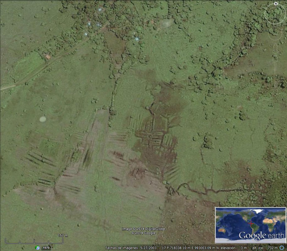
Satellite image of Chinina, eastern Panamá (Google Earth 2014).

Aerial photographs made available by Google show raised field structures near Chinina, a small village, c. 55km east of Panamá City, near the estuary of the Bayano River, a few hundred meters from the Pacific coast. The fields lie on the alluvial plain of the Bayano River and adjacent local water courses (Figure 2).
The raised field structures consist of at least 22 blocks of parallel banks and ditches. The banks or ridges are c. 50m in length, 2.5m wide and 0.6m in height. Between the ridges, there are parallel channels that would protect the crops and retain enough water for the dry season. The whole system is fed by a stream descending from the low hills behind the alluvial plain.
The most visible ridges cover an area of c. 30ha, but there are possibly more field complexes in the surrounding zone. Just 1.5km east-south-east of the described area, there are further, although less clear, structures visible on the aerial photographs (Figure 3).
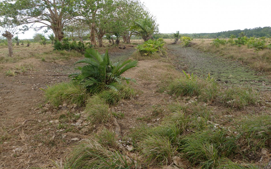
Ridge and canals in Chinina; cattle and erosion are destroying the features.

The landscape today is of pasture with small forested areas, and it is primarily used for cattle grazing. Aerial photographs from the 1970s, however, show that the area was covered with dense tropical forest. High precipitation of c. 5000mm per annum, proximity to the sea and local groundwater conditions combine to mean that the area is flooded for much of the year. Agricultural usage thus required a complex transformation of the landscape.
The field complex has been radiocarbon dated by charcoal to 570±40 BP (Beta 303616: AD 1299–1428 at 95.4%; date modelled in OxCal v.4.2, using IntCal13 calibration curve (Reference Bronk RamseyBronk Ramsey 2009; Reimer et al. 2013)). This would, chronologically, correspond to the late phase of the pre-Hispanic occupation of the so-called Gran Darién (Martin 2002a, 2002b). As a concept, Gran Darién describes a “cultural interaction sphere” or one of the three different “semiotic tradition zones” (see Reference CookeCooke 1973, 1976: 122, 1984: 263–65); it was created together with Gran Coclé and Gran Chiriquí in order to understand and explain the cultural diversity evident in the Panamanian pre-Hispanic archaeological record. Of the three zones or regions, Gran Darién is the least studied by archaeologists due—principally—to practical and logistical factors such as difficulty of access, dense forest cover and, recently, armed conflict.
The present survey was limited to the areas where visibility was high such as pastures and other open areas. There are probably more fields akin to those identified at Chinina, as well as settlement sites, elsewhere in the region. The challenge for the next phase of research is to identify areas of domestic settlement and to characterise these activity areas through extensive excavation.
This research promises to provide a better understanding of regional pre-Hispanic agricultural techniques and their cultural influences. For this purpose, it will be necessary to continue processing the data already collected and to conduct further field seasons to address specific problems related to the Gran Darién. Additionally, we intend to encourage the local community to recover and use these techniques to improve their lifestyles and economy, and to develop environmentally sustainable practices in this fragile ecological region of Panamá.
Acknowledgements
This project would not have been possible without the support and funding of the Foundation for Research on Ancient Panamá and of its director, Dr Patrick Simiskey. We also had the support of the National Institute of Culture of Panamá and its national heritage director, who authorised the investigation.