The ancient city of Petra, Jordan, was named a UNESCO World Heritage site in 1985 and has more recently been added to the list of New Seven Wonders of the World. Lost to the western world until 1812, the 'rose-red city' with its stunning sandstone architecture carved directly into bedrock is truly impressive. First constructed by the Nabataeans starting around 200 BC, and later controlled by the Romans (beginning in AD 106), this desert metropolis is noted for an elaborate water management system that allowed the city to thrive for centuries in an arid region while functioning as an important trading hub for the ancient world (Reference RubenRuben 2003; Reference OrtloffOrtloff 2005). Recent non-destructive geophysical investigations of the so-called Upper Market area (Figure 1) in the Petra city centre have revealed a range of previously unknown features likely to be related to the water management of the city. A thorough understanding of this system is crucial to knowing how and why the city emerged, expanded to a population of 20 000 residents, and eventually fell into decline.
With magnetic and electromagnetic data collected in 2010, a series of processing and modelling procedures were undertaken in order to reveal, enhance and assess parameters of detected features at various depths. This effort involved using techniques of spectral analysis and inverse modelling, including several potential field transformations and dipole parameter estimates of magnetic data. In 2011, follow-up work was undertaken with ground-penetrating radar in order to confirm the findings of the 2010 season, and to gain a higher resolution perspective on certain features. It became clear that interpretations drawn from the radar survey were very much in agreement with interpretations of the magnetic and electromagnetic surveys. Among the several major features revealed, a large channel striking westward from the South Nymphaeum (an architectural and hydrological feature about which little is known; location on Figure 1) exhibits comparable scale to a Roman aqueduct, and also appears to have an arched ceiling. Ceramic water pipes, shallow channels and a possible cistern (of substantial scale) were also detected. The results of all three methods were integrated, along with topographic data, into a virtual model of the site (Figure 2).
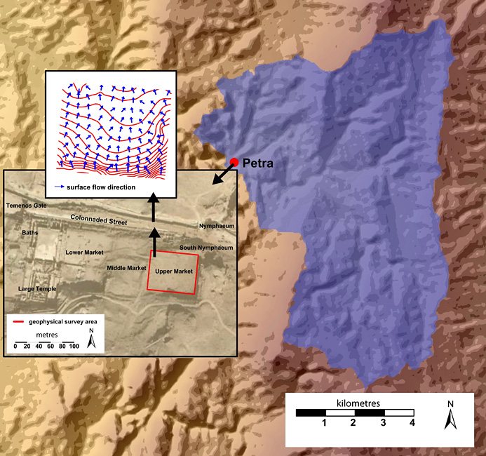
The geographic context of the Upper Market survey. The blue shaded area indicates the Petra watershed as a broader hydrological context for the city. The first inset shows the Upper Market survey area within the city centre, with nearby architectural features. The second inset shows the contoured relief of the Upper Market (at 50cm intervals) with blue vectors indicating the direction and magnitude of surface drainage. This fits well with a broader flow direction model which indicates a south to north flow for water entering the Upper Market as overland flow.

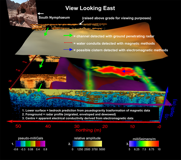
A composite of geophysical results offered as an interpretation summarising some of the major features detected. Rendered 3D models of magnetic water conduits are shown as green cylinders. The lower surface represents the bedrock distribution estimated from a pseudo-gravity transformation of total field magnetic data. The discrete red surface in the centre of the image is an anomalous region of high electrical conductivity, possibly related to the presence of a cistern. Ground-penetrating radar renderings to the left (north) indicate a channel running from the South Nymphaeum, while the radar profile in the foreground offers supporting evidence of features detected with magnetic methods.

The geophysical results offer a virtual glimpse into missing pieces of Petra's water management puzzle, a topic that has generated years of scholarship. It appears from our findings that the Upper Market, an area which previously attracted little attention from archaeologists (cf. Bachman et al. 1921; Reference KanellopoulosKanellopoulos 2002), may have played a significant role in the city's water catchment, storage and distribution. The newly-discovered features necessitate a rethinking of this space, with broader implications for the water management system of Petra.
High-tech methods such as those employed here represent a growing trend in archaeological practice, making rapid site assessments feasible with minimal excavation. This may constitute a major shift in how archaeological sites are thought about and investigated, as archaeology without digging has become a more viable option. Our team will continue with geophysical investigations in other areas of Petra and its surrounding environs, attempting to detect more virtual finds that might offer fresh insight into this remarkable city.
Acknowledgements
This research was supported by the Curtis T. and Mary G. Brennan Foundation, the Joukowsky Institute for Archaeology and the Ancient World at Brown University, the Department of Antiquities, Hashemite Kingdom of Jordan, and the Weidenfeld Research Fellowship.