Introduction
The Messak Project started in summer 2010 as a joint project of the Libyan Department of Archaeology and the Italian-Libyan Archaeological Mission in the Acacus and Messak of Sapienza University of Rome, a three-year programme of heritage research and management of the Messak plateaux in south-western Libya. At the end of February 2011, in the final stages of the first season, the civil uprising interrupted the research and determined the termination of the project. After eight months of conflict, there is growing concern from the international scientific community about the state of the Libyan cultural heritage and its role in the future of the country (http://whc.unesco.org/en/news/799/). In this respect, we believe that communication of the preliminary results of the project can contribute to keep focusing attention on the Libyan situation, and to emphasise the wealth and outstanding value of the cultural heritage in a remote but crucial area for the country.
The Messak massifs between heritage and development
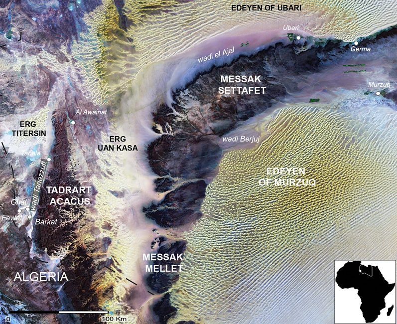
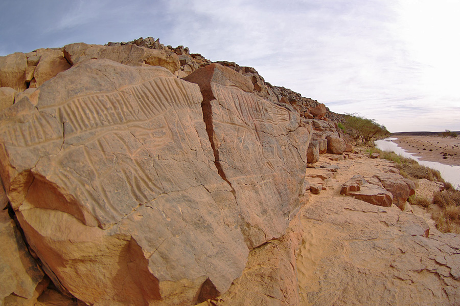
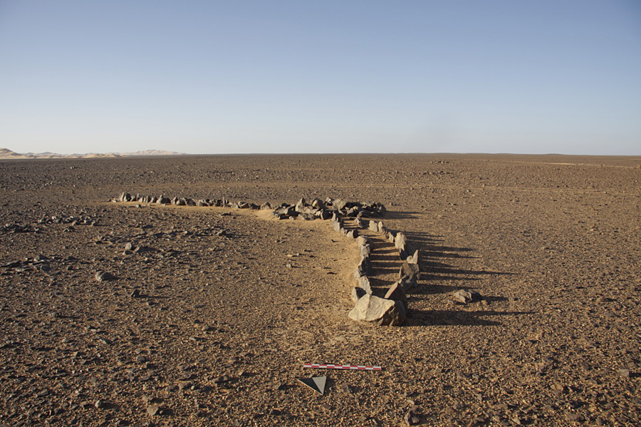
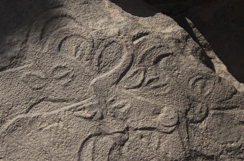
The Messak Settafet and Mellet plateaux, in south-western Libya (Figure 1), are cut by a now dried up fluvial network that, during the humid Pleistocene and Holocene interglacials, favoured human presence (Figure 2). The region, currently arid and inhabited by just one Tuareg family, is a key area of Libya, both for its cultural heritage and its oil resources. The plateaux are dotted by thousands of lithic artefacts and stone structures (Figure 3) ranging in date from the Early Stone Age to historic times, and the cliffs of the wadis host a gallery of petroglyphs among the most impressive in the world (Figure 4). Before the Messak Project, fieldwork mainly focused on Holocene features, particularly rock art and ceremonial stone structures located along the wadis (e.g. Gauthier & Gauthier 2004; di Lernia & Gallinaro 2010), and more rarely on the inner part of the plateaux, where most of the evidence for Pleistocene human frequentation is to be found.
Satellite image of the Messak Plateaux and neighbouring areas.

Wadi Matkhandush, the most famous rock art site of the Messak Settafet, after rain.

Example of a stone monument (antenna-type) in the Messak Mellet.

Detail of a rock art scene, Messak Settafet.

In the last decade several rescue or preventive archaeological operations related to oil prospecting and associated activities were carried out in the central and southern areas of the Settafet and in the northern part of the Mellet, allowing us to evaluate the amount of damage oil resources exploitation is causing (Cremaschi & di Lernia 2000; Anag et al. 2002; Kröpelin 2002; Mattingly et al. 2006; Gallin & Le Quellec 2008) and to contain the impact of the new infrastructures (Le Quellec 2009). Unfortunately, these activities remained isolated and the region still lacks a comprehensive management plan, shared by the local authorities and all the stakeholders.
Research programme
The Messak Project consists of three main phases: i) knowledge acquisition; ii) conservation; and iii) sustainability. It was to be implemented over the period 2010–2012 and received effective support from an international Honorary Board composed of 12 experts in Saharan history, culture and environment.
When the project was suspended, it had reached the final stages of the first phase, whose aims were to: a) expand the knowledge of the region; b) evaluate the state of preservation of the natural and cultural heritage; and c) define the risks for the cultural and environmental heritage.
The first steps focused on collecting all the data available and creating a GIS-linked database. This was followed by a three-month field campaign between December 2010 and February 2011, aimed at exploring previously unknown areas of the plateaux, and the work ended with the processing of the data.
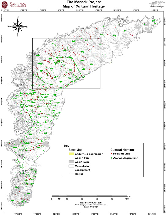
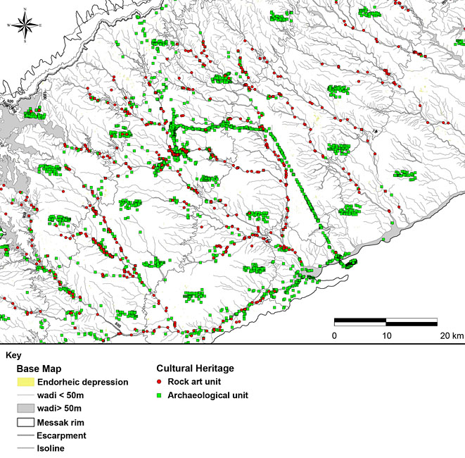
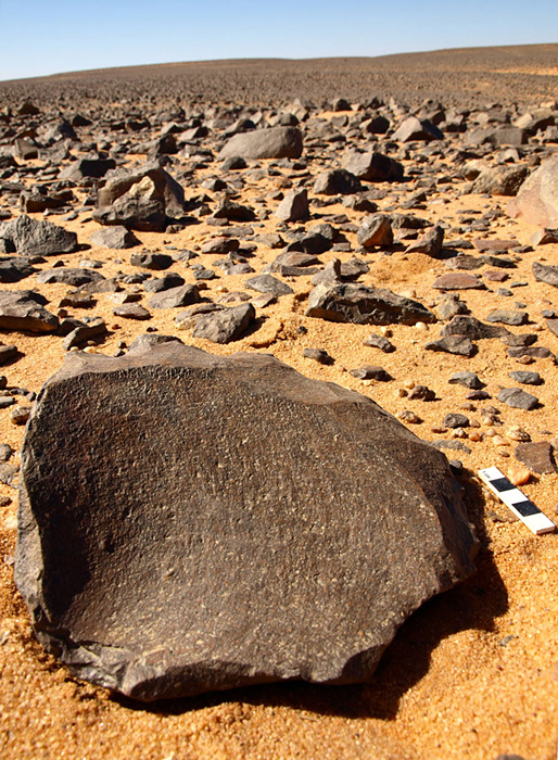
Data on c. 9000 archaeological entities, half of which are unpublished sites from the past 30 years of research, were entered into a geo-database, creating the first geo-archaeological map of the region (Figures 5 and 6). This gave a wider view of the location of archaeological evidence and revealed the presence of sites in a great variety of settings. The development of statistically based predictive models will enhance the understanding of occupation dynamics in the region in different periods. The types of sites and their periods of occupation vary greatly. While most data refer to the Holocene, Pleistocene evidence is undeniably remarkable (Figure 7), also featuring some unexpected ancient records relative to the earliest phases of the Early Stone Age. Other data refer to the frequentation of the plateaux over the last two millennia (e.g. tifinagh inscriptions, caravan routes or nomad campsites).
Results
Map of cultural heritage (general view).

Map of cultural heritage (detail).

Close-up of a Levallois core within a large Pleistocene site, Messak Settafet.

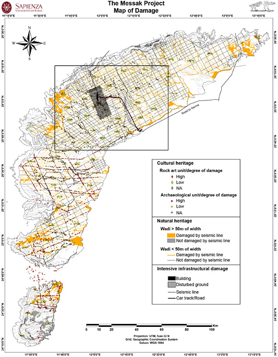
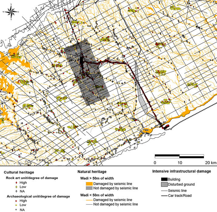
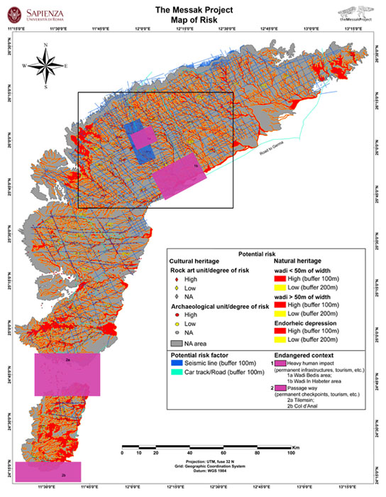
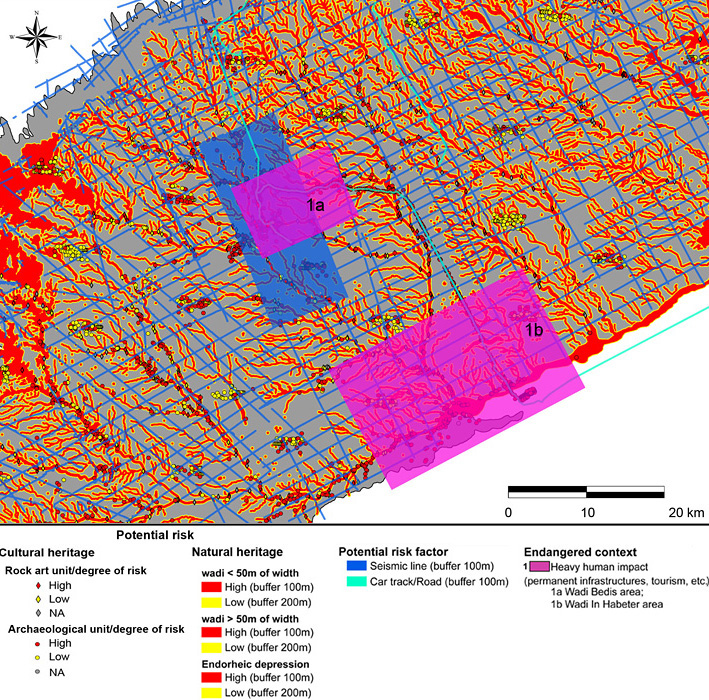
One of the main outcomes of the Messak Project is the map of damage sustained (Figures 8 and 9). The extent of damage caused to each archaeological and rock art site was assessed and all recent activities caused by human agency (such as car tracks, roads, oil research facilities and infrastructures) were recorded. This resulted in a thematic map synthesising the state of the environmental and cultural heritage as at February 2011 and a map of the potential risk to the natural and archaeological heritage (Figures 10 and 11). These maps provide a new tool for planning conservation strategies of the heritage of the Messak region. Evidence of different types and levels of damage and risk for archaeological and rock art sites, as well as for the wadis, forms the basis for the selection of restoration priorities and the definition of areas requiring special protection measures.
Map of damage (general view).

Map of damage (detail).

Map of risk (general view).

Map of risk (detail).

Perspectives
Our results have highlighted an unexpected wealth and diversity of the region's cultural heritage in terms of quantity, complexity and chronology. These resources have already been severely damaged and further work on the potential risks still affecting the region is relevant for their future management. Due to their economic, cultural and tourist value, the Messak plateaux will play a key role in the future development of the country. We urge that the resumption of economic activities be accompanied by immediate efforts by politicians and stakeholders, including international bodies such as UNESCO and ICCROM, to adopt management plans aimed at the sustainable development of the region.
Acknowledgments
We wish to thank Dr Saleh Al-Raghb, chairman of the Libyan Department of Archaeology in Tripoli, and Mr Bashir Galgam for the logistic organisation in Libya. A particular thank to the team of archaeologists, geologists and surveyors, who participated in the desktop and field activities: Luisa Barbato, Gabriele Berruti, Cinzia Filippone, Cecilia Parolini, Alessandro Perego, Chiara Pizzi, and Vittorio Mironti. Savino di Lernia designed and directed the Messak Project; Marina Gallinaro acted as Project Manager; Stefano Biagetti coordinated the fieldwork; Alessandro Vanzetti supervised the conservation and restoration studies. The contribution to the database is equally shared between Sapienza team and Jean-Löic Le Quellec, Yves and Christine Gauthier. The GIS platform, its implementation, analyses and maps, have been developed by Marina Gallinaro (Sapienza team). Warmest thanks to the members of the Honorary Board: Ali Arnaouti, Abdelgader Abu Faid, Graeme Barker, Francesco Bandarin, Mounir Bouchenaki, Jean Clottes, Mauro Cremaschi, David Coulson, Stefan Kröpelin, Rudolph Kuper, Mario Liverani and Mark Stanley Price. The Messak Project was financially supported by Eni (Italian energy company), entrusted to Savino di Lernia (Sapienza, contract 2010/001522).