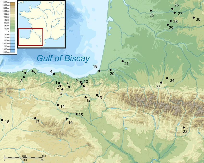
Map of the western Pyrenean region with relevant Lower Palaeolithic or early Middle Palaeolithic sites: 1) Arlanpe; 2) Axlor; 3) Lezetxiki; 4) Mendieta I & II; 5) Urrunaga; 6) La Garma; 7) Morín & Covalejos; 8) El Castillo; 9) Astigarraga; 10) Irikaitz; 11) Arnaileta; 12) Urbasa; 13) Pamplona Bassin; 14) Murba; 15) Matamala; 16) Najerilla Valley; 17) Atapuerca; 18) San Quirce de Río Pisuerga; 19) Lestaulan; 20) Le Tambaou; 21) Bouheben; 22) L'Estret de Tragó; 23) Lanne Darré; 24) Montmaurin; 25) Barbas I; 26) La Micoque; 27) Grotte Vaufrey; 28) La Plane Mare; 29) Camp de Peyre; 30) Pradayrol.

Introduction
The Lower to Middle Palaeolithic transition in Western Europe is a long and complex process that is difficult to assess from an epistemological, chronological and behavioural point of view (Reference MonnierMonnier 2006). Around 300 kyrs BP some elements of material culture, such as the Levallois technique (Mode 3) appear in several assemblages, but undisputed Mode 2 or Acheulean assemblages are still present until almost OIS (Oxygen Isotope Stage) 5e (≈115 kyrs BP) in different regions (Santonja & Villa 2006). These final Acheulean assemblages share Middle and Lower Palaeolithic traits and are crucial to understanding the patchwork nature of the transformation processes of Neanderthal societies during this period.
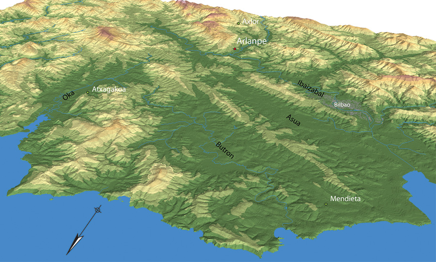
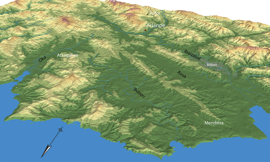
Arlanpe is a small cave (Universal Transverse Mercator coordinates: x: 519254; y: 4782262; z: 204) located on the northern slope of the Cantabrian Cordillera, 25km from the Atlantic coast in northern Spain (Figures 1 & 3). This is a strategic location, close to a low mountain pass (600m asl) located upstream from the site that connects with the Alavese plateau, and near the confluence of two main rivers, the Arratia and the Ibaizabal that drain a major part of Vizcaya province (Figure 2).
DTM (Digital Topographic Model) of Biscay region with the position of Arlanpe Cave.
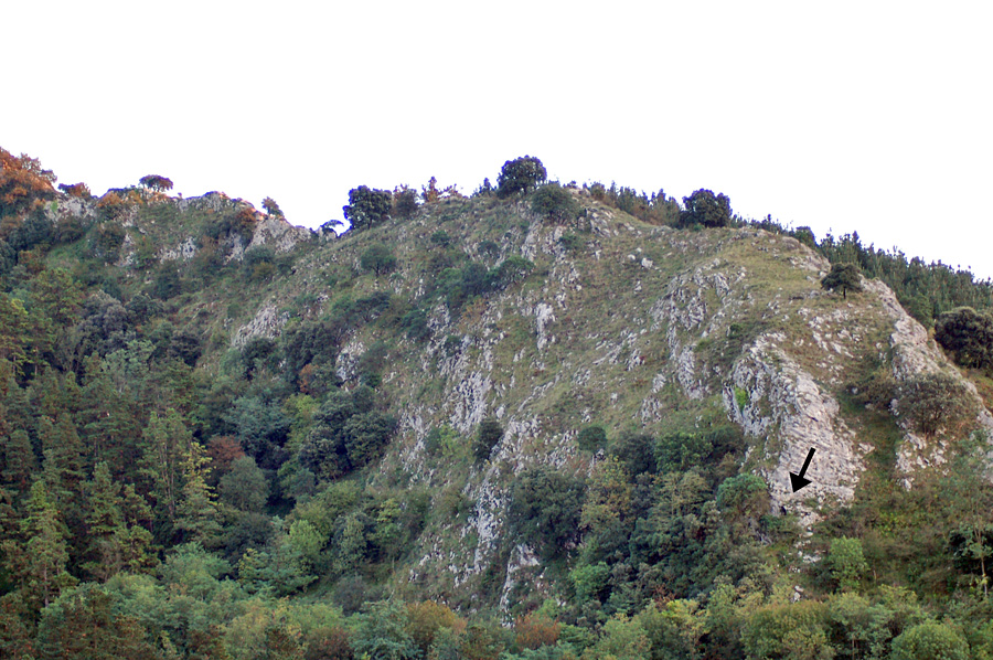
Location of the entrance of the cave in the Arlanpeko Atxa (Arlanpe Crag).

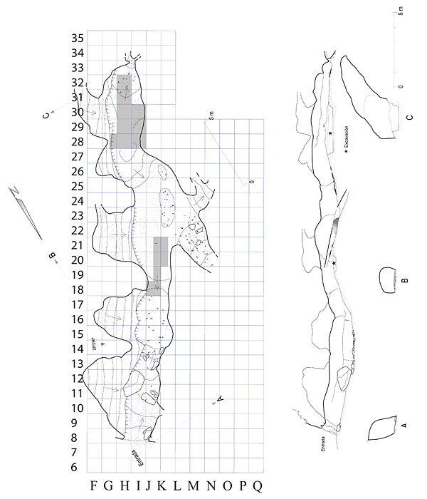
Plan of Arlanpe Cave with the excavation areas shaded.

Excavations have been ongoing since 2006 and cover a surface area of 11m² (Figure 4). Two different excavation areas have yielded evidence for the Upper Acheulean (Levels C and D), the Upper Solutrean (Levels II and III) (Rios-Garaizar et al. 2008b), the Magdalenian (Level I), as well as Bronze Age and Late Roman occupations. The Upper Acheulean level D is notable for its good preservation compared to other assemblages in the Cantabrian region (Reference ArrizabalagaArrizabalaga 20052006). The ongoing project comprises systematic excavation and analysis of archaeological and paleontological material and geological processes to characterise these occupations and the relevance that they have towards assessing the nature of the LowerMiddle Palaeolithic transition in Western Europe.
First results
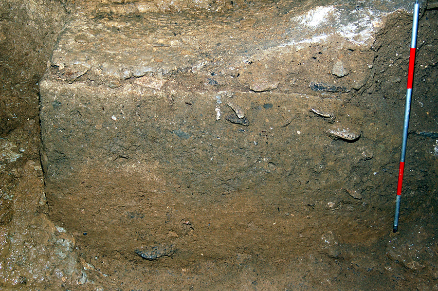
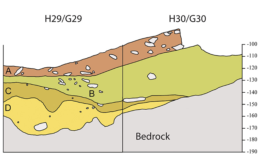
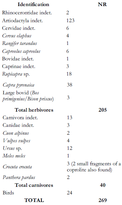
Level D has so far been exposed over a surface area of 3m² and to a depth of 0.3m (Figures 5 & 6). It is formed by endokarstic sand and clay, and its surface has been reworked by running water during the formation of level C. Level D has yielded abundant well-preserved faunal and lithic remains. Regarding the faunal remains (Table 1), herbivores constitute the majority of the assemblage and the most represented species is Pyrenean ibex (Capra pyrenaica), followed by chamois (Rupicapra sp.). Medium- to large-size carnivores such as bear (Ursus sp.), fox (Vulpes vulpes), spotted hyena (Crocuta crocuta), dhole (Cuon alpines) or leopard (Panthera pardus) are also represented, but taphonomic analysis reveals that they had a secondary role in the bone accumulation. This level has also yielded a large microvertebrate assemblage including mammals, reptilians and amphibians. The presence of Apodemus sylvaticus-flavicollis (woodmouse) and dormice (Eliomys quercinus and Glis glis) indicates a woody environment. The presence of these taxa decreases towards the top of the level indicating a subtle change towards colder conditions.
Photograph of the section along the western edge of excavation square H29 at the rear of the cave.

Section drawing along the western edge of excavation squares H29 & H30 at the rear of the cave.


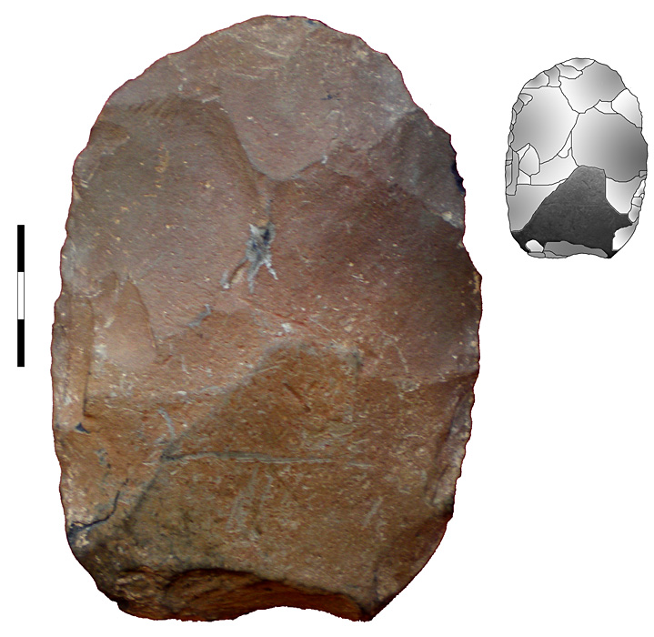
Handaxe made on silicified mudstone recovered in surface.

Initial results from pollen analysis suggest relatively warm and wet climate conditions during the formation of level D, with a predominance of deciduous trees among arboreal taxa, for example hazel (Corylus), lime (Tilia), birch (Betula), alder (Alnus) and oak (Quercus robur tp.). Grasses and heath plants (Ericaceae) dominate in the herbaceous-shrub vegetation, and the values of fern spores are around 45 per cent. The combined evidence suggests a rocky-wooded environment in relatively warm and wet conditions that suggest an Eemian age for level D. Amino acid racemization dating is ongoing, and a single bear incisor from the upper part of level D has yielded a minimum age of 63 kyrs BP, but more dates are obviously needed.
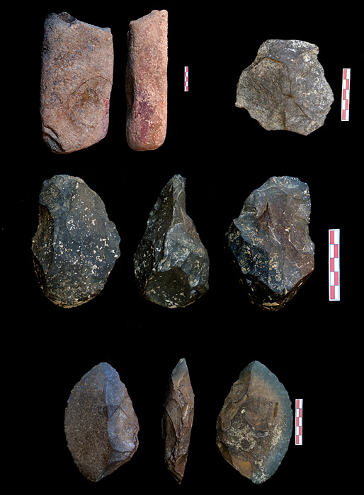
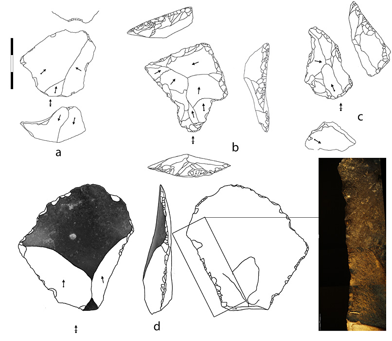
Stone tools are relatively abundant (>50 pieces larger than 20mm per m²). Raw materials include non-local flint (available 3070km away) as well as local materials including silicified mudstone, quartz or sandstone. The ratio of local:non-local raw materials is 2:1. These local materials exhibit less retouch modification and are considerably larger in size. There is evidence of handaxe production (Figure 7, 8) in level D as well as in the altered level C. Flint tools were produced using the Levallois technique and imported to the site as intensely retouched formal tools, mainly sidescrapers (Figure 9). Silicified mudstone is exploited in situ by SSDA (Système par surface de débitage alterne) (Reference ForestierForestier 1993) and discoid techniques to obtain large partially cortical flakes. Formal tools made on mudstone (see Figure 8, 9) are mainly thick denticulate and naturally-backed knives.
Massive tools (including handaxes and bifacially backed flakes) made on sandstone and silicified mudstone.

a) Pseudo-Levallois point made on silicified mudstone; b) flint Levallois flake transformed into convergent sidescraper; c) convergent Quina sidescraper made on flint; d) cortical SSDA flake with use-wear made on silicified mudstone.

Discussion
The transition between the Lower and Middle Palaeolithic is a poorly documented period in Western Europe. Few sites in the Cantabrian region and south-western France provide information about tool provisioning and subsistence strategies during the Upper Acheulean. Thus, Arlanpe Cave offers a rare glimpse into the changes that took place from the Lower to the Middle Palaeolithic among Neanderthal communities.
Our ongoing studies reveal that occupation occurred during relatively warm and humid conditions, probably corresponding to the Eemian interglacial (MIS 5e). The faunal assemblage shows a high taxonomic diversity, reflecting the variety of landscapes around the site. Despite the abundance of carnivores at the site, humans were the main agents of the faunal accumulation. The lithic assemblage reveals some transitional features, including simpler technologies applied to local raw materials as well as the presence in the same level of well-developed Levallois (Mousterian-like) technology. This could reflect individual provisioning strategies mainly relying on local raw materials supplemented by good quality non-local tools.
Similar features have been described for late Lower Palaeolithic and early Middle Palaeolithic (200115 kyr BP) assemblages of Western Europe (Santonja & Villa 2006; Slimak et al. 2010; Turq et al. 2010). In the eastern Cantabrian region only the cave of Lezetxiki has produced comparable results in climatic, faunal and lithic records (Arrizabalaga et al. 2010; Castaños et al. 2011). These features are clearly different from those exhibited on older sites in the same region (Arrizabalaga & Iriarte 2008; Rios-Garaizar et al. 2008a), which have yielded evidence for more expedient technologies. Arlanpe Cave's Level D also distinguishes itself from local Mousterian cave assemblages with a chronological range of 8040 kyrs BP where more complex technological management or subsistence strategies, extensive landscape use and solid evidence for the controlled use of fire are evident (Reference Rios-GaraizarRios-Garaizar 2009).
Acknowledgements
The project is funded by the Barandiaran Foundation, the Regional Government of Vizcaya, and the Basque Government. Asier Gómez-Olivencia has a postdoctoral fellowship from the Ministerio de Educación (Programa Nacional de Movilidad de Recursos Humanos del Plan Nacional de I+D+I (20082011) and also receives support from the Spanish Ministerio de Ciencia e Innovación (Proyecto CGL2009-12703-C03-03). Thanks to Rolf Quam for revising our Iberian English.