


Introduction
The Vistula Spit is one of the largest sandy coastal barriers of the southern Baltic coast. This over 100-km-long landform comprises an extensive system of dune ridges and inter-dune peatbogs. Based on morphological criteria, the dunes of the Vistula Spit were traditionally distinguished into the older, lower so-called “brown dunes,” situated further from the sea shore and younger, higher so-called “yellow dunes” (Łabuz et al. Reference Łabuz, Grunewald, Bobykina, Chubarenko, Česnulevičius, Bautrėnas, Morkūnaitė and Tõnisson2018; Tomczak et al. Reference Tomczak, Mojski, Krzymińska, Michałowska, Pikies and Zachowicz1989; Uścinowicz et al. Reference Uścinowicz, Adamiec, Bluszcz, Jegliński and Miotk-Szpiganowicz2021). Despite the prolonged interest in the Holocene development of the Vistula Spit, its geochronologic framework was so far only recognized based on boreholes and shallow ditches. As a consequence of indirect collection of samples, placing the dated deposits in adequate stratigraphic context was hindered. Apart from luminescence dating of dune sand (Fedorowicz et al. Reference Fedorowicz, Gołębiewski and Wysiecka2009, Reference Fedorowicz, Wysiecka, Zieliński and Hołub2012; Uścinowicz et al. Reference Uścinowicz, Adamiec, Bluszcz, Jegliński and Miotk-Szpiganowicz2021), 14C ages of 43 samples were determined so far from the whole approx. 50 km long Polish part of the Vistula Spit. In a recent review of existing 14C dates, Uścinowicz et al. (Reference Uścinowicz, Adamiec, Bluszcz, Jegliński and Miotk-Szpiganowicz2021) summarized reports from Tomczak et al. (Reference Tomczak, Mojski, Krzymińska, Michałowska, Pikies and Zachowicz1989); Uścinowicz (Reference Uścinowicz2003); Zachowicz and Uścinowicz (Reference Zachowicz, Uścinowicz and Florek1997). Those concern 19 dates from limnic mud and peat deposits in a deep substrate of the coastal barrier, 7 dates of mollusk shells from near-shore marine deposits, as well as five dates from non-buried inter-dune peat bogs and two dates of shallowly buried paleosols. So far, there were no 14C dates from the transect covered in the present study.
Construction of the Vistula Spit shipping canal during 2020–2022 offered a unique opportunity to document the deposits and collect samples directly in the excavations. Approx. 1.3 km excavation transect was oriented perpendicularly to the coast and cross-cut over 25 m high dune ridge. Here, we compile 21 new accelerator mass spectrometry (AMS) 14C dates of 16 samples collected from sedimentary succession. The present contribution aims to supplement the knowledge about time frames of the Vistula Spit development, thus enabling to refine the model of Southern Baltic coastal zone evolution.
Material and methods
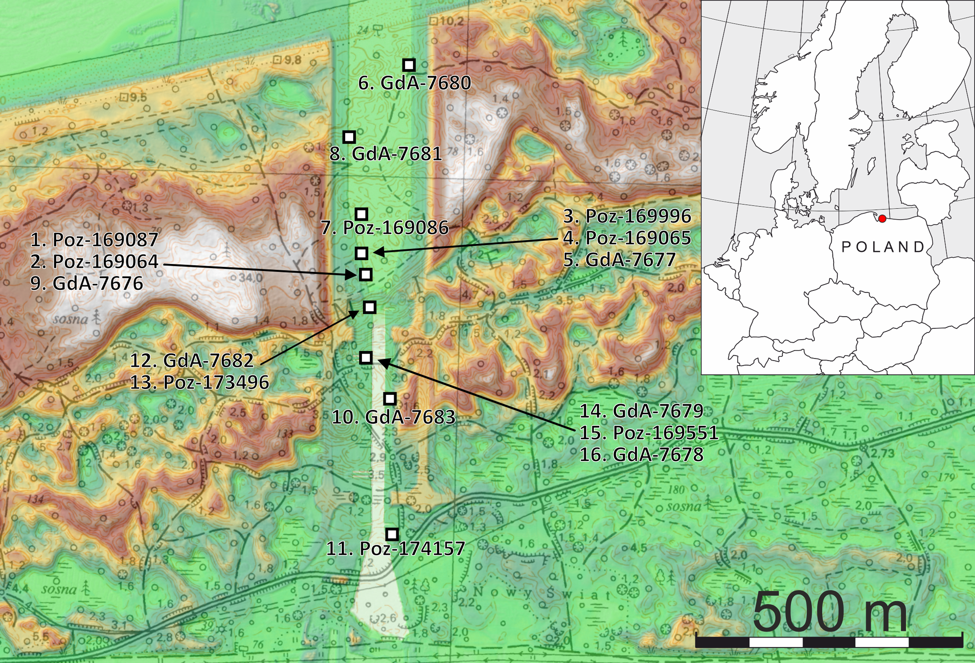
Sample collection was conducted at the excavations temporarily accessible during the Vistula Spit shipping canal construction (Figures 1 and 2; Table 1). Approximate values of sample location depth in relation to present-day sea level and to original (pre-earthworks) land surface are given in Table 1. Collected material comprised bulk samples of cohesive deposits (peat and marine mud), as well as individually collected charcoals and plant remains dispersed in paleosols, wood and mollusk shells from marine deposits. The separation of individual plant remains from bulk peat and mud samples was performed in the laboratory conditions.
Location of sampling sites in the Vistula Spit canal excavation.

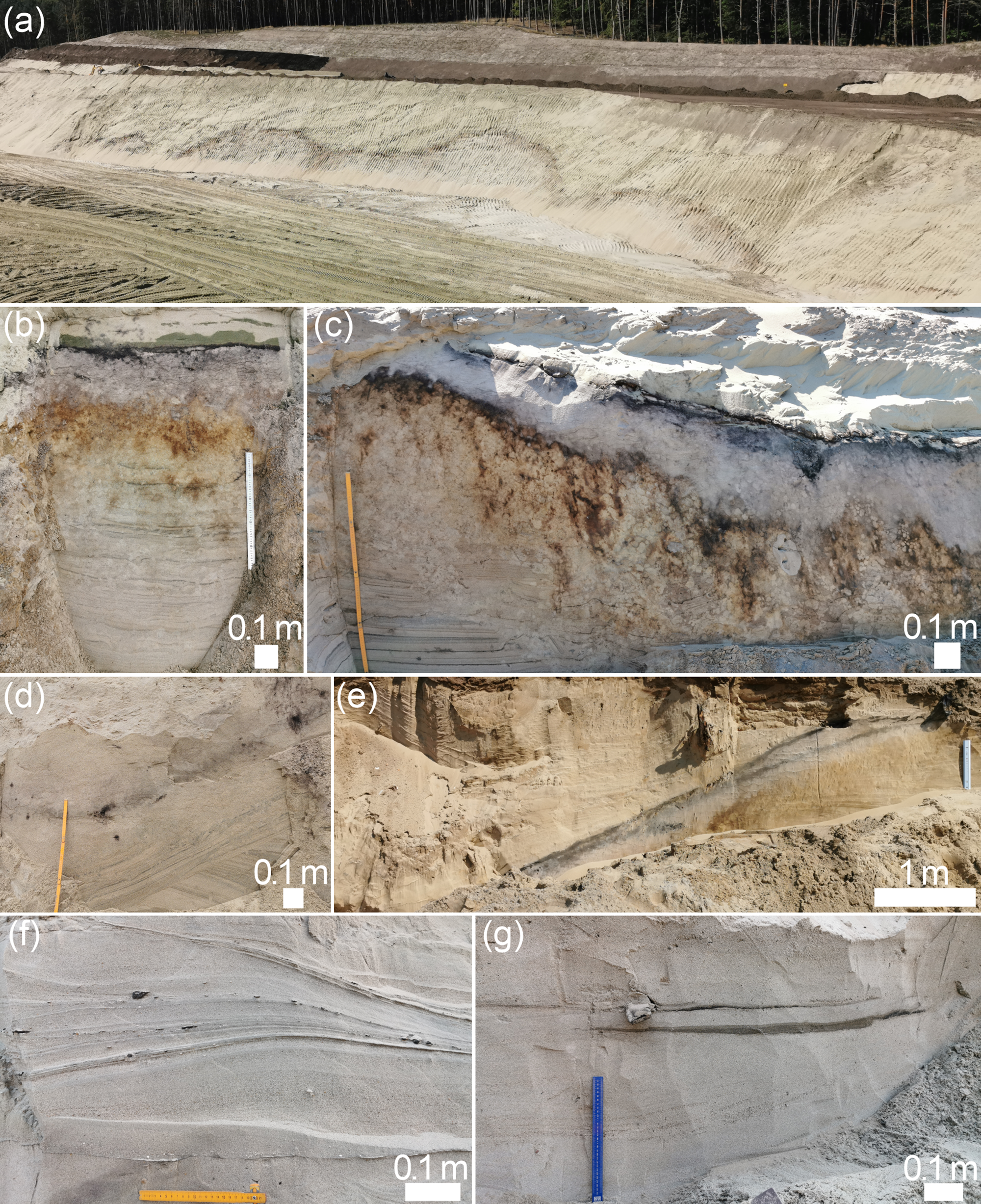
Examples of dated deposits. (a) General view of podzolic paleosol developed on buried dune hillocks (samples 6–8); (b) Detailed view of the same paleosol; (c) Exemplary buried peat lens (samples 1–5); (d) Weakly developed buried Arenosol, from which sample 10. was collected; (e) Incipient podzolic paleosol in the oldest generation dune, from which sample 11. was collected; (f) Buried beach deposits containing mollusk shells and plant remains (samples 12. and 13.); (g) Marine shoreface deposits with mud intercalations (samples 14.–16.).

List of samples with background information, dating and calibration results

AMS 14C dating of 8 samples was conducted by Poznań Radiocarbon Laboratory (laboratory code designation Poz) and the remaining by Gliwice Radiocarbon Laboratory (laboratory code designation GdA; Table 1). Sample pretreatment at Poznań Radiocarbon Laboratory as described by Goslar (Reference Goslar2025) generally followed the procedure of the Oxford Radiocarbon Accelerator Unit and comprised sequential treatment of the material with 1M HCl (80°C), 0.025-0.2M NaOH (80°C), 0.25M HCl (80°C) and rinsing with deionized water after each reagent. The first HCl treatment lasted until gas bubble emanation of the sample ceased, no less than 20 min, and the second for 1 hr. NaOH treatment was repeated until no coloration of the solution was observed, but no less than 5 min. In the case of mollusk shell sample, the preparation comprised sequential treatment with 15% H2O2 in an ultrasonic bath, 0.5M HCl, and again 15% H2O2. Subsequently, the remaining calcium carbonate was leached with concentrated H3PO4 in a vacuum line.
Combustion of the material, conducted in sealed quartz tubes in the presence of CuO and Ag, lasted for 10 hr in 900°C. Graphitization was conducted next, which involved reducing CO2 obtained in reaction with H2, in the presence of Fe powder as a catalyst. Resultant graphite target was pressed into an aluminum cathode holder. In the case of mollusk shell sample, CO2 was leached by treating with concentrated H3PO4 in a vacuum line. 14C content from the samples was measured using a Compact Carbon AMS spectrometer made by National Electrostatics Corporation (Goslar et al. Reference Goslar, Czernik and Goslar2004). The process comprised a comparison between 14C, 13C, and 12C ionic beam intensities, measured for each sample and for standard samples (modern standard: Oxalic Acid II and 14C-free coal).
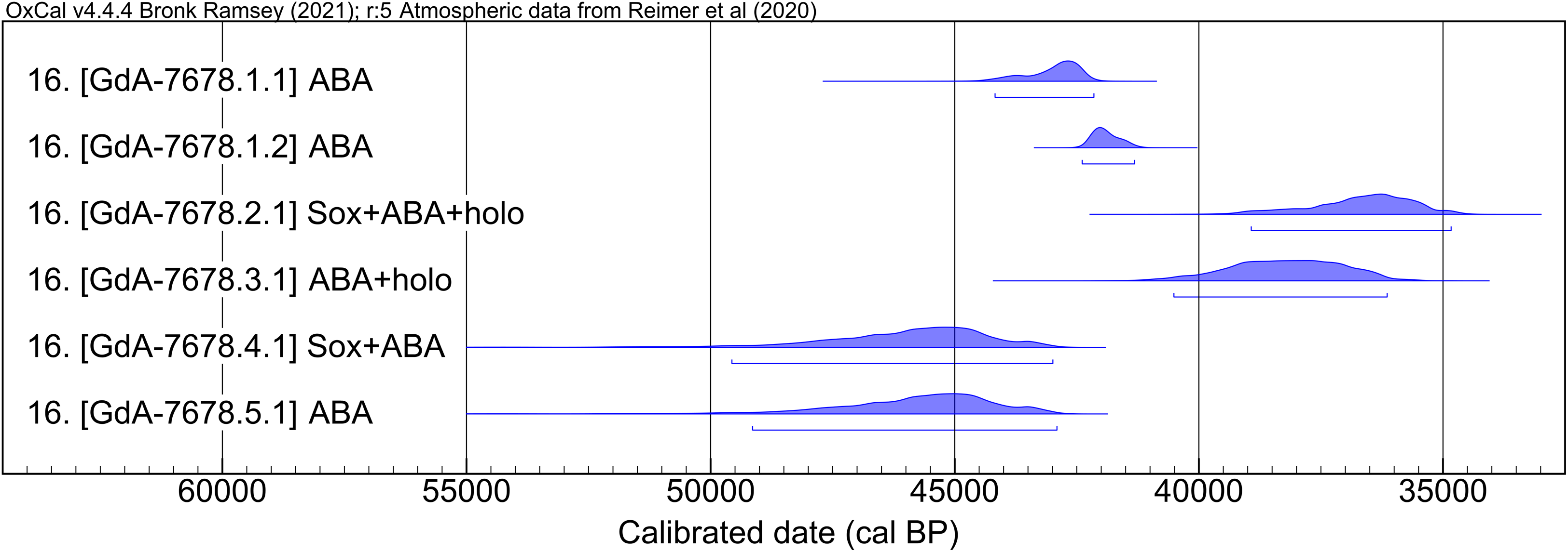
Sample pretreatment in the Gliwice Laboratory was performed following the ABA (acid-base-acid) protocol reported by Ustrzycka et al. (Reference Ustrzycka, Piotrowska, Kłusek, Pawełczyk, Michczyńska, Michczyński, Kozioł and Jȩdrzejowski2025) for organic remains. The first step was treatment with 0.5 M HCl for 1 hr at 85°C. Afterwards, 0.1 M NaOH was used to remove the humic compounds for 1 hr at 85°C. Then the samples were subjected to 0.5 M HCl for 1 hr at 85°C. After each step the samples were rinsed with demineralized water until a neutral pH was reached. The last step was drying at 60°C. In case of wood sample no 16. [GdA-7678], more elaborate treatments were applied to sub-samples, namely Soxhlet cleaning (50/50 mixture of ethanol and toluene, 80°C for 2 hr) and holocellulose extraction with use of 5% NaClO2 acidified to pH=2 by adding HCl (70°C for 1 hr). The material was then packed into tin capsules and combusted with use of Vario Micro Cube (ElementarTM) elemental analyzer, and CO2 transferred to automated graphitization equipment AGE-3 system to produce elemental graphite (Němec et al. Reference Němec, Wacker and Gäggeler2010; Wacker et al. Reference Wacker, Němec and Bourquin2010). The graphites, pressed into cathodes, were analysed for 14C concentration by the MICADAS spectrometer along with the reference samples, as described by Ustrzycka et al. (Reference Ustrzycka, Piotrowska, Kłusek, Pawełczyk, Michczyńska, Michczyński, Kozioł and Jȩdrzejowski2025).
Calculated conventional 14C ages were corrected for isotopic fractionation based on measured δ13C values and reported at 1σ uncertainty, being the best estimate of total measurement uncertainties. Calibration was conducted using OxCal v4.4 (Bronk Ramsey Reference Bronk Ramsey2009), with IntCal20 calibration curve (Reimer et al. Reference Reimer, Austin, Bard, Bayliss, Blackwell, Bronk Ramsey, Butzin, Cheng, Edwards and Friedrich2020) for terrestrial samples and Marine20 curve (Heaton et al. Reference Heaton, Köhler, Butzin, Bard, Reimer, Austin, Bronk Ramsey, Grootes, Hughen, Kromer, Reimer, Adkins, Burke, Cook, Olsen and Skinner2020) for the mollusk shell sample. In the latter case, to compensate for the reservoir effect, ΔR=-119 and σ=50 values determined for the Gdańsk Bay (Lougheed et al. Reference Lougheed, Filipsson and Snowball2013; Reimer and Reimer Reference Reimer and Reimer2001) were adopted. Calibration results are reported at the 95.4% confidence level and rounded up to tens (Tables 1–2; Figures 3–4).
Pretreatment protocols, dating and calibration results of sample 16 (wood fragment from facies IV)

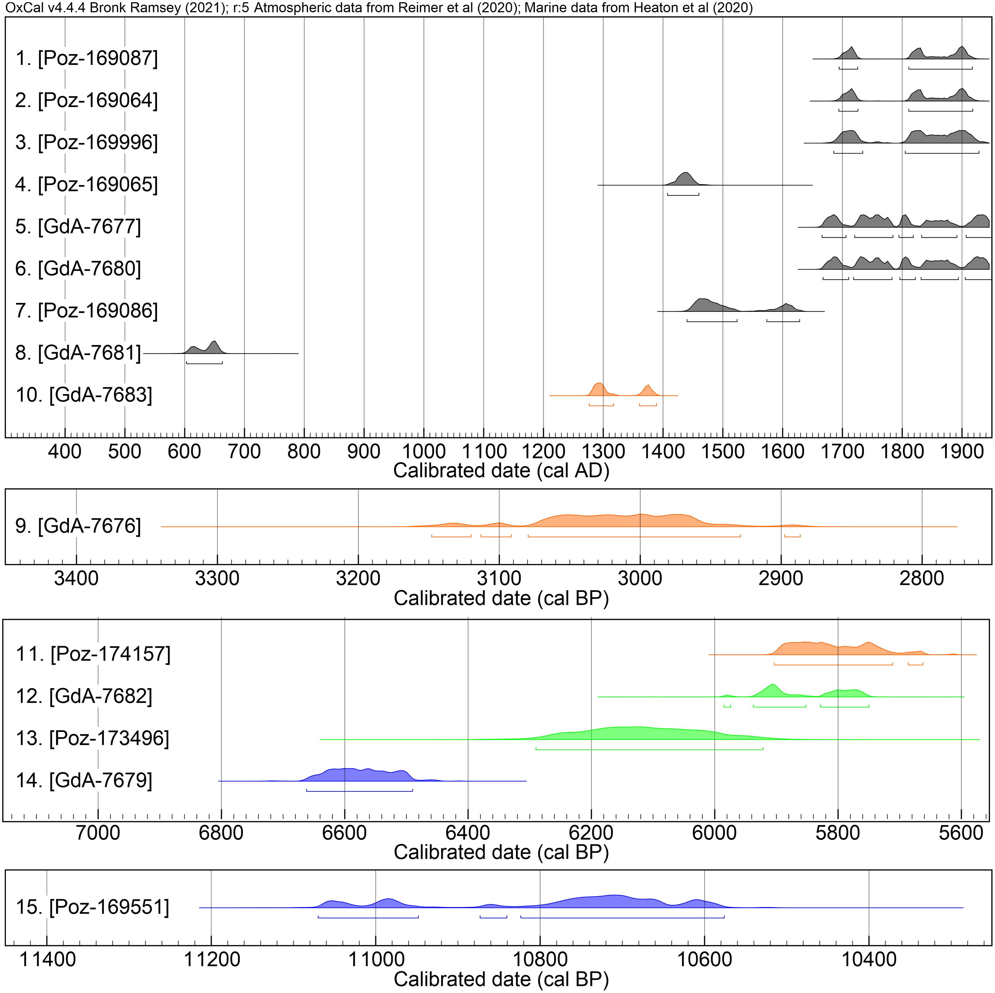
Calibrated 95.4% range probability distributions of Anno Domini (cal AD; upper plot) and older (cal BP; three lower plots) dates. Particular sedimentary facies plotted in different colors: I – gray; II – orange; III – green; IV – blue.

Calibrated 95.4% range probability distributions of results obtained from sample 16 (wood fragment) using different pretreatment protocols (ABA – acid-base-acid; Sox – Soxhlet; holo – holocellulose).

Results
Radiocarbon dating results and calibration are summarized in Tables 1–2 and Figures 3–4. Dated material represents four distinct sedimentary facies types (ordered I–IV; Table 1), distinguished from each other by lithological properties and stratigraphic position. Facies I) comprises peat lenses and a distinct, well-developed podzolic paleosol horizon, which together are in stratigraphic continuity (Figure 2a–c). The paleosol forms a continuous horizon, laterally traceable in meridional cross-spit transect over ca. 550 m distance. An undulated morphology of this paleosurface reflects the morphology of older-generation dune hillocks (Figure 2a), on which the podzolic soil was developing prior to its burial by advancing transgressive dune ridge. In the low lying paleo-interdune depressions, peat bogs were developing (cf. samples 1–5). Strongly compacted by the load of overlying sand, peat is preserved in the form of approximately 5 cm thick lenses which laterally pass into the podzolic paleosol (Figure 2c). To the facies II), separate horizons occurring in the deposits of older-generation dunes are ascribed, that are either buried below transgressive dune ridge or situated to the south from that dune ridge (Figure 2d, e). Facies III) comprises beach deposits that underlie the dunes and record the transition from marine to terrestrial conditions (Figure 2f). Underlying facies IV) represents shallow marine sand and gravel deposits with occasional muddy intercalations (Figure 2g).
Samples 1. [Poz-169087] and 2. [Poz-169064]
The southernmost peat lenses, buried below the crestal part of transgressive dune ridge, reaching 23 m thickness in that place. Samples 1. [Poz-169087] and 2. [Poz-169064] consisted of bulk peat collected from top and bottom of the layer, respectively, and were dated to 260–220 cal BP or 140–30 cal BP.
Samples 3. [Poz-169996], 4. [Poz-169065] and 5. [GdA-7677]
Represent a similar buried peat lens, located ca. 30 m north from the previous one. Bulk peat samples 3. [Poz-169996] and 4. [Poz-169065] were collected from top and bottom of the peat lens, respectively. The obtained age of top layer was 270–210 cal BP or 150–20 cal BP, while the bottom sample was dated to 550–490 cal BP. Sample 5. [GdA-7677] consisted of wood fragment extracted from the lower part of peat layer and its age covers a wide interval from 290 cal BP to the present, due to wiggles in calibration curve for this period.
Samples 6. [GdA-7680], 7. [Poz-169086] and 8. [GdA-7681]
Were collected from the organic-rich topsoil horizon of buried podzolic paleosol. Age of sample 6. [GdA-7680], which comprised plant remains from the northernmost outcrop of this paleosol, covers an interval from 290 cal BP to the present. Sample 7. [Poz-169086], an assemblage of charcoals from the location approximately 400 m to the south-west from the previous one, was dated to 510–420 cal BP or 380–320 cal BP. It was distinguished by abundant cattle hoofprints occurring on the interface between the paleosol and overlying sand. Sample 8. [GdA-7681] was an assemblage of charcoals collected approximately halfway between the two previous records and dated to 1350–1280 cal BP.
Sample 9. [GdA-7676]
An assemblage of charcoals collected from ca. 0.8 m thick albic horizon below the peat lens, which age covers an interval from 3150 to 2880 cal BP.
Sample 10. [GdA-7683]
An assemblage of charcoals from the paleosol buried in a dune hillock to the south of large transgressive dune’s front, morphologically belonging to the oldest (so-called “brown”) generation dune. The paleosol represents an initial stage of development (Arenosol) and significantly differs visually from podzolic paleosols described in other samples. The sample was dated to 680–630 cal BP or 590–560 cal BP.
Sample 11. [Poz-174157]
An incipient podzolic paleosol buried in the southernmost dune hillock cut by the canal excavation, of the oldest (“brown”) generation. The symptoms of podzolization are less advanced compared to the podzolic paleosol buried below the transgressive dune. Its age covers an interval from 5910 to 5660 cal BP.
Samples 12. [GdA-7682] and 13. [Poz-173496]
Represent sandy-gravelly beach deposits that occur at the base of aeolian dune deposits. They were mostly devoid of organic remains, with the exception of one layer at the sampled location, from which both samples were collected. Sample 12. [GdA-7682] represents an assemblage of small wood fragments dated to 5990–5750 cal BP, and sample 13. [Poz-173496] gastropod and bivalve shells dated to 6290–5920 cal BP.
Samples 14. [GdA-7679], 15. [Poz-169551] and 16. [GdA-7678]
Represent shallow marine shoreface facies (facies IV), exposed at depths 5–6 m below the present day sea level in the excavation for the canal’s lock. Sample 14 [GdA-7679] consisted of plant remains preserved in coarse-grained sand and gravel deposits that dominate the shoreface facies and was dated to 6660–6490 cal BP. The remaining two samples, which comprise a seed and wood fragment respectively, were collected from fine-grained mud layer. Age of the former covers an interval from 11,070 to 10,580 cal BP.
The results obtained for the first fragment of wood sample 16 [GdA-7678] gave surprisingly old 14C dates of 39,140 ± 800 BP and 37,300 ± 490 BP. Therefore, some attempts were made to confirm these dates on a second wood sub-sample, using different preparation protocols in order to remove possible contamination with external organic substances and to isolate the holocellulose fraction. The ages generally show that the more elaborate the preparation method used, the more modern carbon contamination was added and the sample age was rejuvenated. Holocellulose extraction also resulted in drastically low yields as most of the material was dissolved. As similar observations were reported by Jędrzejowski et al. (Reference Jȩdrzejowski, Michczyńska, Kłusek, Michczyński, Pawełczyk, Piotrowska, Wyss Heeb and Hajdas2024) for fossil wood material from a Miocene deposit, the age of sample 16 cannot be excluded to be outside the radiocarbon method range. Nevertheless, all results yielded ages indicating deposition of an object much older than the sediment age.
Discussion and conclusions
Results obtained from the paleosol and peat lenses ascribed to facies I) range from the 7th to the 18th centuries AD. Surface stabilization and development of podzolic paleosol on the older-generation dune hillocks commenced no later than 600 AD, as indicated by Sample 8. [GdA-7681]. Two dates (peat – sample 4. [Poz-169065] and paleosol – sample 7. [Poz-169086]) from the same paleosurface point to its development during the late Middle Ages (15th century). The youngest dates obtained for several samples of peat and podzolic paleosol (facies I) with a good consistency indicate 1660–1920 cal AD range. This period marks an interruption of peat and paleosol development as a result of burial below the rapidly advancing transgressive dune ridge. Notably, those time frames can be constrained to ca. 100 years between the second half of 17th–late 18th century AD based on archival cartographic material (Anonymous 1877; Schrötter Reference Schrötter1802). These show that in the 19th century the transgressive dune ridge was already stabilized and overgrown by an artificially planted forest.
The charcoal assemblage of sample 9. [GdA-7676] occurred within the extent of albic material below the peat lens formed during 17–18th centuries AD. Nonetheless, age of this charcoal assemblage in the 3150–2880 cal BP range suggests that it is in fact a residue of the paleosol that was shallowly buried in the oldest generation (“brown”) dune. In turn, 13th–14th century AD range represented by sample 10. [GdA-7683] indicates that upper part of “brown” dunes was subjected to remobilization during late Middle Ages, presumedly in relation to human activities recorded in the podzolic paleosol of similar age (sample 7. [Poz-169086]; Ninard et al. Reference Ninard, Łapcik and Uchman2023a,b).
From the paleosol buried in the southernmost of the oldest generation (“brown”) dune hillocks (sample 11. [Poz-174157]), 5910–5660 cal BP age range is determined which marks stabilization of those oldest dunes. This result fits well with OSL and 14C dates reported by Uścinowicz et al. (Reference Uścinowicz, Adamiec, Bluszcz, Jegliński and Miotk-Szpiganowicz2021) from a similar setting, approx. 1.8 km to the east; two sand samples from shallow excavations in dune hillocks are dated at 4960 OSL yr BP and 5910 OSL yr BP dates; a peat sample from the bottom of unburied peat bog at 5318–5050 cal BP.
Synchronously, deposition of beach facies occurred to the north (sample 12. [GdA-7682] and sample 13. [Poz-173496]), preceded by deposition of shallow marine shoreface facies (samples 14. [GdA-7679], 15. [Poz-169551] and 16. [GdA-7678]). By comparison with the age of overlying beach deposits, 6660–6490 cal BP range of the sample 14. [GdA-7679] can be considered to accurately represent the time of shoreface facies deposition. The remaining two samples evidently represent significantly older material that was subjected to redeposition.
Acknowledgments
This study was supported by grants from the Faculty of Geography and Geology under Strategic Programme Excellence Initiative at the Jagiellonian University (Research Support Module and Anthropocene Priority Research Area); research subsidy from the Institute of Geological Sciences, Jagiellonian University; and internal Polish Geological Institute - National Research Institute grant no 61.2701.2400.00.0. N. Piotrowska and M. Kłusek received support from EU funds FSD – 10.25, Development of higher education focused on the needs of the green economy European Funds for Silesia 2021–2027: The modern methods of the monitoring of the level and isotopic composition of atmospheric CO2 (project no. FESL.10.25-IZ.01-06C9/23-00).

 Open access