


The fortified site of Guiengola, located on the Pacific Coast of the Isthmus of Tehuantepec (hereafter, Isthmus), is one of the settlements built by the Zapotecs outside their traditional home region of the highland Central Valleys of Oaxaca, during their migration in the Late Postclassic period (a.d. 1350–1521) (Ramón Celis et al. Reference Ramón, Guillermo, Ayala and Fuentes2023). Until now, most research on this migration from the Central Valleys to the Isthmus of Tehuantepec has relied heavily on ethnohistoric documents that focus on the lives of nobles and elite politics to understand sociopolitical dynamics (Oudijk Reference Oudijk2008; Whitecotton Reference Whitecotton1985; Zeitlin Reference Zeitlin, Alexander and Kepecs2018). Consequently, the fourteenth- to fifteenth-century Zapotec migration has been interpreted as the outcome of ongoing struggles and competition among elites, which portrays the nonelites who accompanied them as blind followers of their rulers’ political desires.
This article draws on original findings from the Guiengola Archaeological Project (GAP), with an analysis of the urban layout to understand the social and political organization of Guiengola, and in addition, it situates Guiengola within the broader politics of the Late Postclassic period. The GAP was designed to go beyond Zapotec elite versions of history and foreground commoner life at the migrants’ destination. In this article, I analyze the diverse patterns of construction at Guiengola by examining the urban layout across different sectors of the site, focusing on the particularities, similarities, and differences of each sector. My analysis makes visible different patterns of residential construction—including commoner neighborhoods, shedding light on the lives of people who not only built the city but carried the burden of this human migration and contributed heavily to making it a success—in addition to the actions of elite political decision-makers. In the analysis that follows, I first situate the scholarly contributions of the GAP within ethnohistorical and archeological research on Guiengola. Then, I share the GAP's analysis of the urban layout of Guiengola based on archaeological surveys and a lidar scan, which is followed by a section that contextualizes these findings within existing research about urbanism in Mesoamerica, particularly Oaxaca. I focus on the identification of commoner neighborhoods, or barrios, in Guiengola, comparing them with research on urban organization in colonial Tehuantepec. I conclude by arguing for recognition of Guiengola as not just a fortress but a city.
Guiengola in the southern Isthmus of Tehuantepec
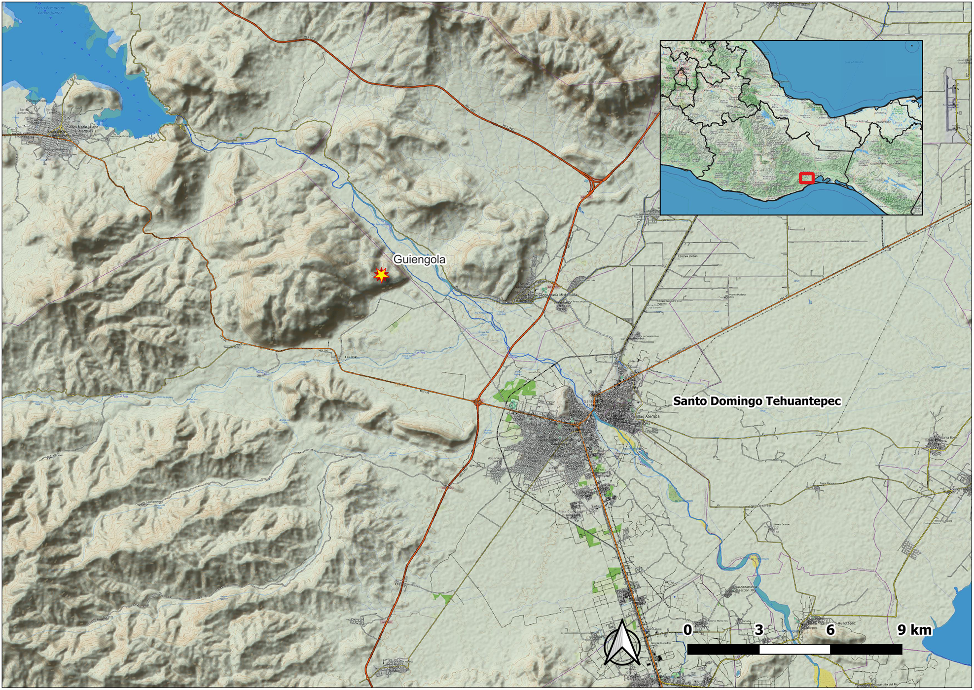
Guiengola was an urban settlement that covered an area of 360 ha in the southern Isthmus of Tehuantepec, Oaxaca, Mexico, and was built over a plateau on the southeast corner of the mountain of the same name (Figure 1). Depictions of Guiengola in the Relación Geográfica de Tehuantepec, a Spanish document from 1577, describe it as the fortification where the Zapotec army emerged victorious against the Mexica invasion that happened in a.d. 1497 (Acuña Reference Acuña1984). The accuracy of this information has been reinforced through oral tradition, which was initially recorded by the Dominican friar Francisco de Burgoa (Burgoa Reference Burgoa1989 [1674]). Based on these documents, it has been inferred that the initial settlement occurred in the Postclassic period; however, there is no depiction of Guiengola as a town or urban settlement in historical records from the sixteenth century. This leads one to suspect that the settlement was most likely abandoned before a.d. 1521, when Spanish settlers arrived in the region, but that it kept functioning as a fortress in times of need.
Location of Guiengola in the southern Isthmus of Tehuantepec.
When the Zapotecs migrated to the southern Isthmus of Tehuantepec from the Central Valleys, the Isthmus was already populated by Chontal, Mixe, Zoque, and Huave people. Ethnohistorical research traced the Zapotec's initial migration and their colonization of the Isthmus by the year a.d. 1350, when Coqui (Lord) Cocijoeza 11 Water, the king of Zaachila (a site in the Central Valleys of Oaxaca), commenced a series of conquests and built Zapotec settlements—including Jalapa and Guevea—motivated by the desire to control important commercial routes between the Mexican highlands and tropical lowlands (Oudijk Reference Oudijk2000, Reference Oudijk2019). During the fifteenth century, the presence of Zapotecs in the Isthmus generated a series of conflicts with the Mexica, who were expanding their presence toward Chiapas and the Pacific coast of Guatemala (Berdan Reference Berdan2007; Hassig Reference Hassig1988). Due to the expansion of the Mexica empire and the Mixtec kingdom of Cuilapam in the Central Valleys, the Zapotec royal family was forced to relocate to the Isthmus (Oudijk Reference Oudijk2000, Reference Oudijk2019). From there, the family members garrisoned in Guiengola to resist a major attack led by Ahuizotl in a.d. 1497 and were able to withstand a seven-month siege. As part of the conflict resolution, the two forces arranged a marriage between the daughter of the Mexica emperor and the Zapotec heir, Cocijopii, who was ruling in Tehuantepec at the time of the Spanish arrival (Whitecotton Reference Whitecotton1985). In sum, the historical documentation does not provide information about Guiengola beyond its significance as a fortification. Furthermore, there is no sufficient historical data on how nonelites were incorporated into the construction and everyday life of the site, nor does existing research provide insight on how these individuals adapted their lifestyles and livelihoods to a new and different environment.
Archaeological research has provided clear evidence that Guiengola was a permanent settlement with much more complexity than is given in the ethnohistorical descriptions. Colonial documents only describe Guiengola as a fortress, but previous archaeological projects have revealed public, ceremonial, and residential areas. It is worth mentioning those carried out by Edward Seler (Reference Seler1904), Peterson and MacDougall (Reference Peterson and MacDougall1974), and Fernandez Davila (Reference Fernández Dávila2021). These projects made valuable contributions to our understanding of the site, especially with the documentation of a ceremonial precinct composed of the two largest temples in the settlement; however, without access to modern remote-sensing tools, previous projects were unable to capture the full extension of the site (Sepúlveda Chiñas Reference Sepúlveda Chiñas2005). Guiengola is located in a hard-to-access plateau covered by subtropical dry broadleaf forest, making it logistically challenging to survey (Martín Regalado et al. Reference Regalado, Natalia, Gómez-Ugalde and Palacios2011). In addition, the canopy makes it nearly impossible to identify architecture with aerial photographs.
With these major obstacles in mind, the GAP created a complete map of the site by conducting a lidar scan in December 2022, given that it is a tested and trusted archaeological approach to large-scale mapping of mountainous terrain with dense vegetation (McCoy Reference McCoy2020). Prior to completing the lidar scan, the project had carried out three field seasons of systematic survey and mapping (between 2018 and 2022) to discern the size of the city using GPS, which confirmed the existence of a cluster of buildings on the east slope of the mountain that covered an estimated area of 360 ha.
Combining the data collected from the pedestrian survey and the lidar imagery analysis, the GAP identified 1,173 structures. The GAP then selected 90 of these buildings for intensive survey, where detailed architectural plans were made. The average area of these buildings was 100 m2. During the analysis, the structures were initially classified into three architectural categories: monumental, military, and residential. Monumental architecture included structures that were built for ceremonial, religious, political, or administrative purposes. Examples of monumental architecture included pyramids, temples, ballcourts, palaces, administrative buildings, plazas, civic spaces, and altars. Military architecture included defensive walls and buildings associated with them. Finally, residential structures were those that were identified as dwellings and structures meant for habitation.
A total of 2,292 archaeological artifacts were registered, identified, and typologically analyzed from these 90 buildings. Diagnostic ceramics, such as fine gray pottery with zoomorphic supports, and Mixteca-Puebla sherds allow us to infer that the city was occupied in the Late Postclassic period (a.d. 1200–1521). There was no evidence of a preexisting settlement, and all buildings were built during this time span (Ramón Celis Reference Ramón Celis2024; Ramón Celis et al. Reference Ramón, Guillermo, Ayala and Fuentes2023).
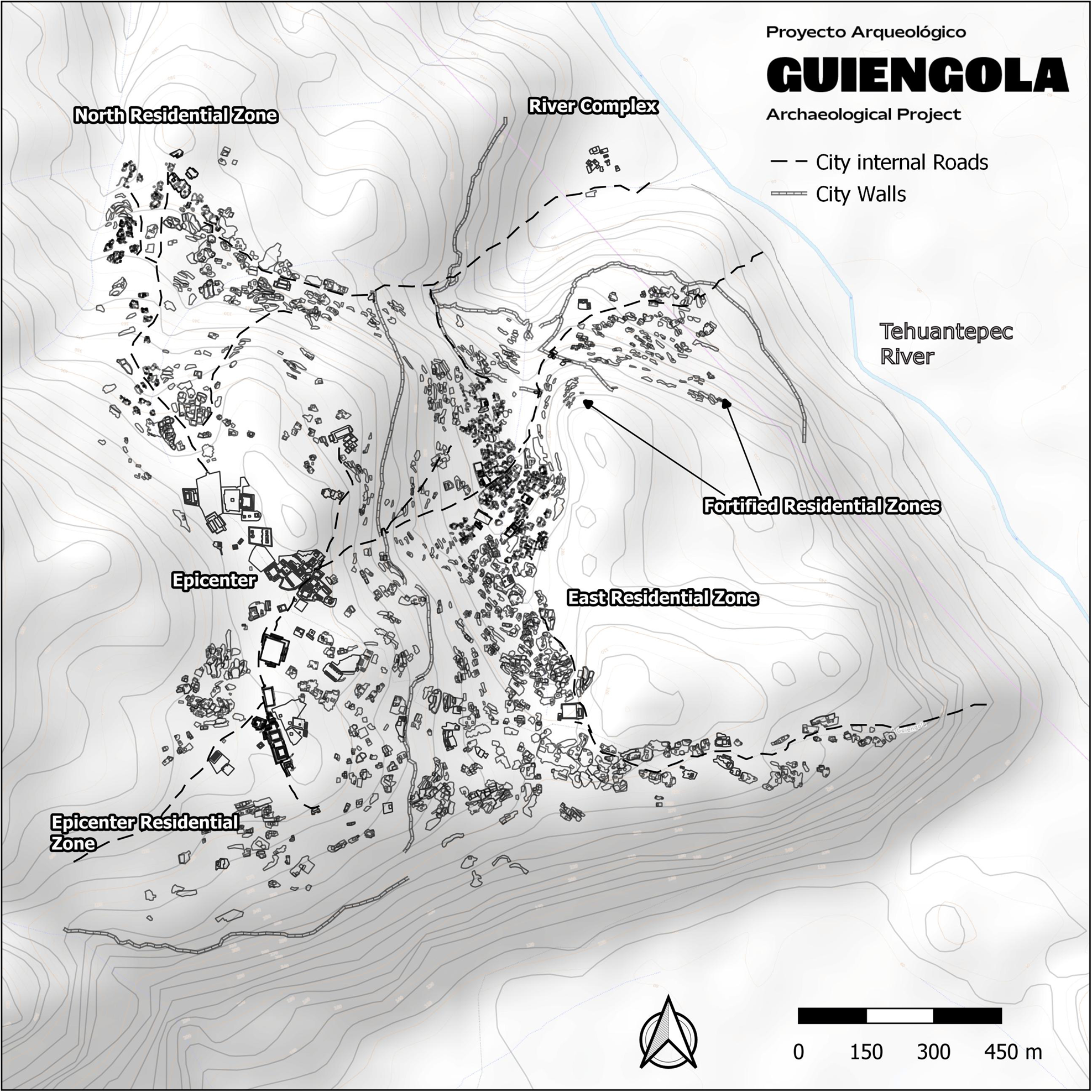
The geospatial analysis of the GAP's lidar scan and archaeological survey reveals a sprawling site spanning 360 ha (Figure 2). The settlement has evidence of intricate social organization based on neighborhoods, or barrios—kin-based structures similar to those that have been documented in early colonial Tehuantepec (Covarrubias Reference Covarrubias1946; Oudijk Reference Oudijk2019; Zeitlin Reference Zeitlin2005), where the descendant population of Guiengola currently lives. The following three sections of the article discuss how the GAP's analysis of a sophisticated walled system of fortifications, intricate internal road networks, and evidence of a hierarchically organized city gives insight into the complexities not just of the elite's control and autonomy of Guiengola but also of the way commoners dwelled and organized themselves economically, religiously, and socially, constructing spaces and modifying the landscape to create their home.
Map of the archaeological site.
Urban layout of the site
The maps generated by pedestrian surveys and lidar (Figures 2–8) document the urban layout of the site. The different zones of the city, discussed below, including five residential zones and one external construction cluster, consist of public and religious buildings, elite and commoner residences, agricultural terraces, and a series of walls with gates allowing movement between them, which existed not just to protect the city but to control the circulation of people within the settlement. In this regard, the GAP identifies a clear differentiation of spaces between elite and commoner residences, including an urban epicenter (see, for example, Smith Reference Smith2005 for nomenclature).
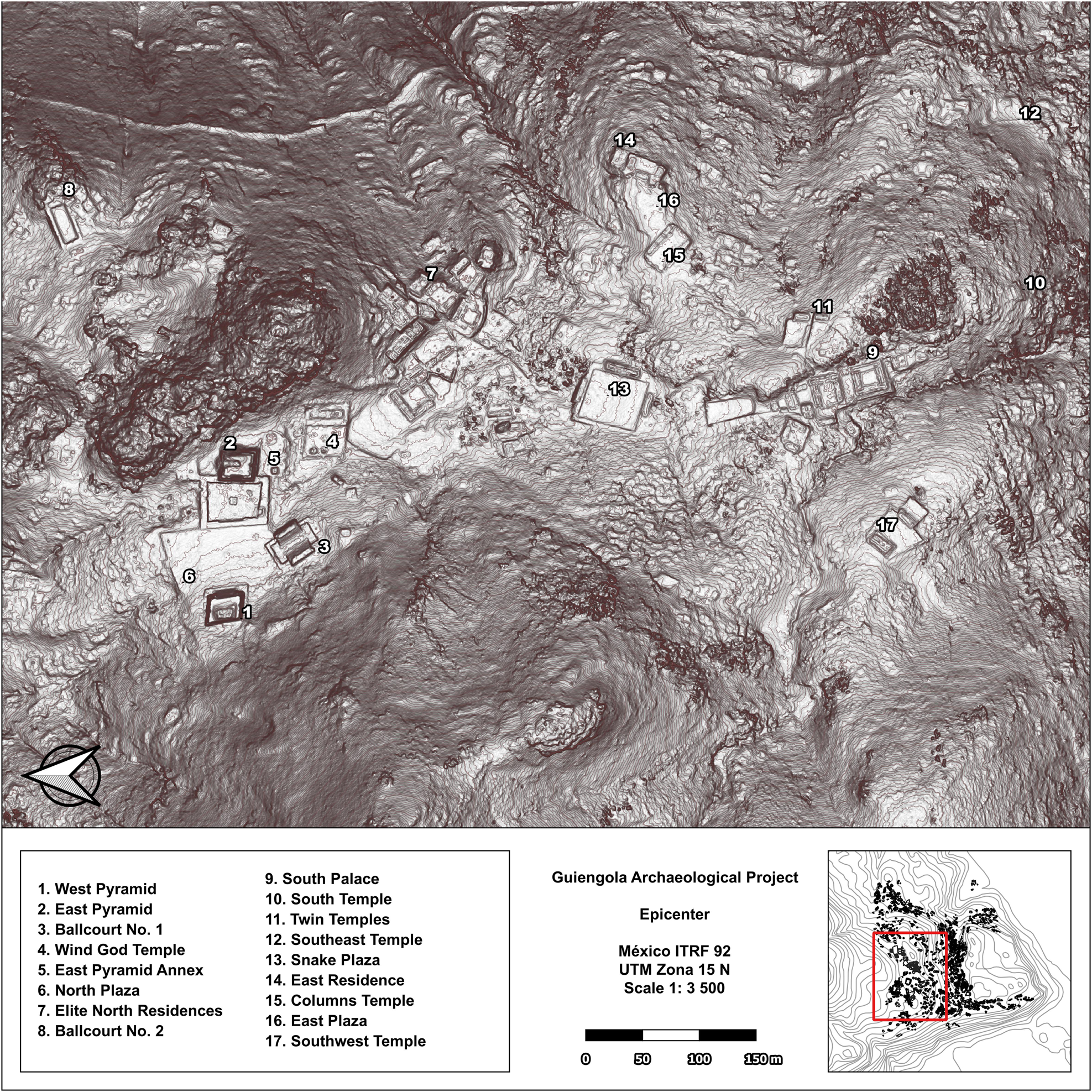
Epicenter of the city. The biggest buildings of the city were found in this area surrounded by the main wall.
North of the Epicenter. It is possible to observe public spaces, such as the North Plazas, and private elite spaces, such as the Ballcourt No. 2.
South Palace Complex. The main structure was constructed by clearing the bedrock.
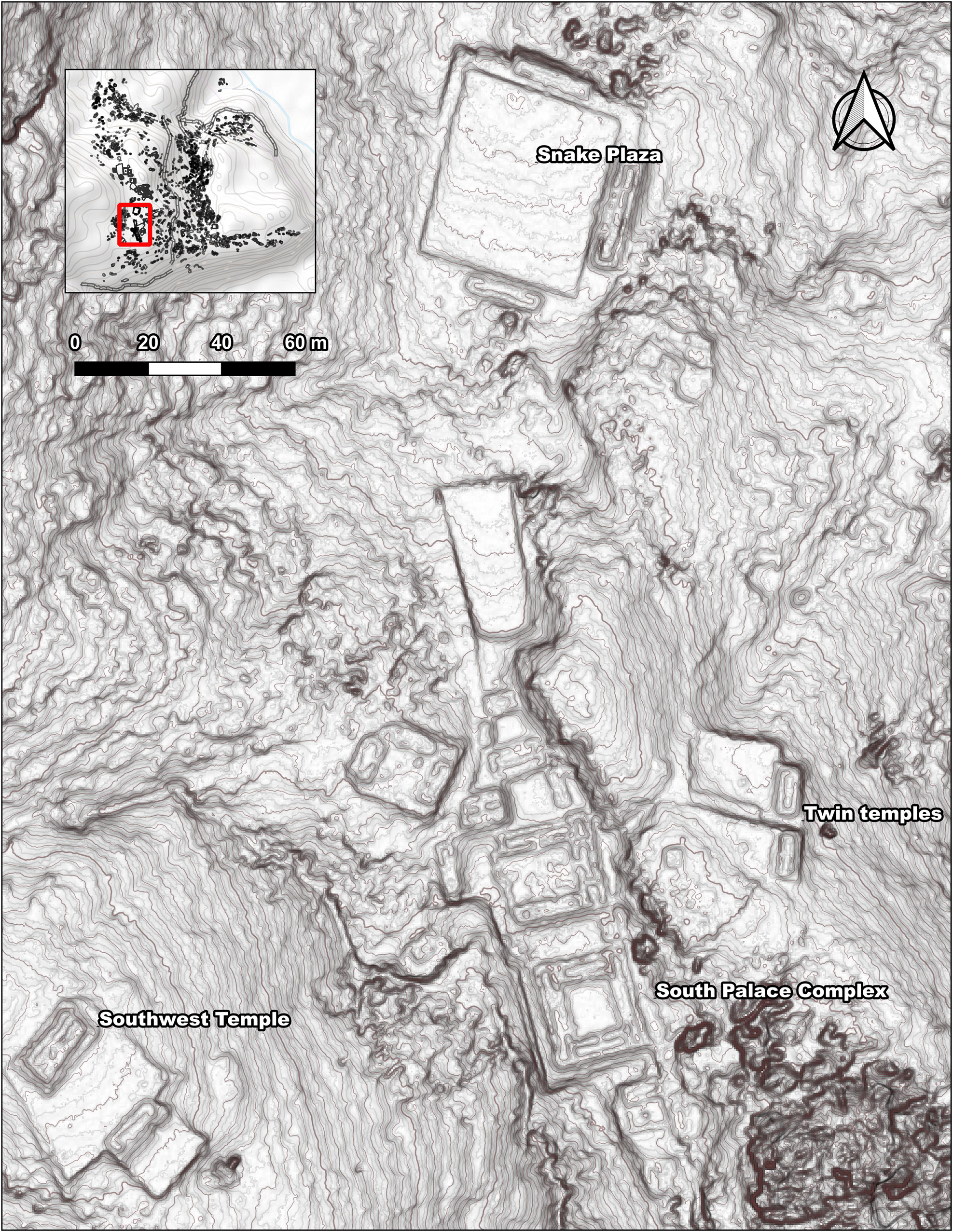
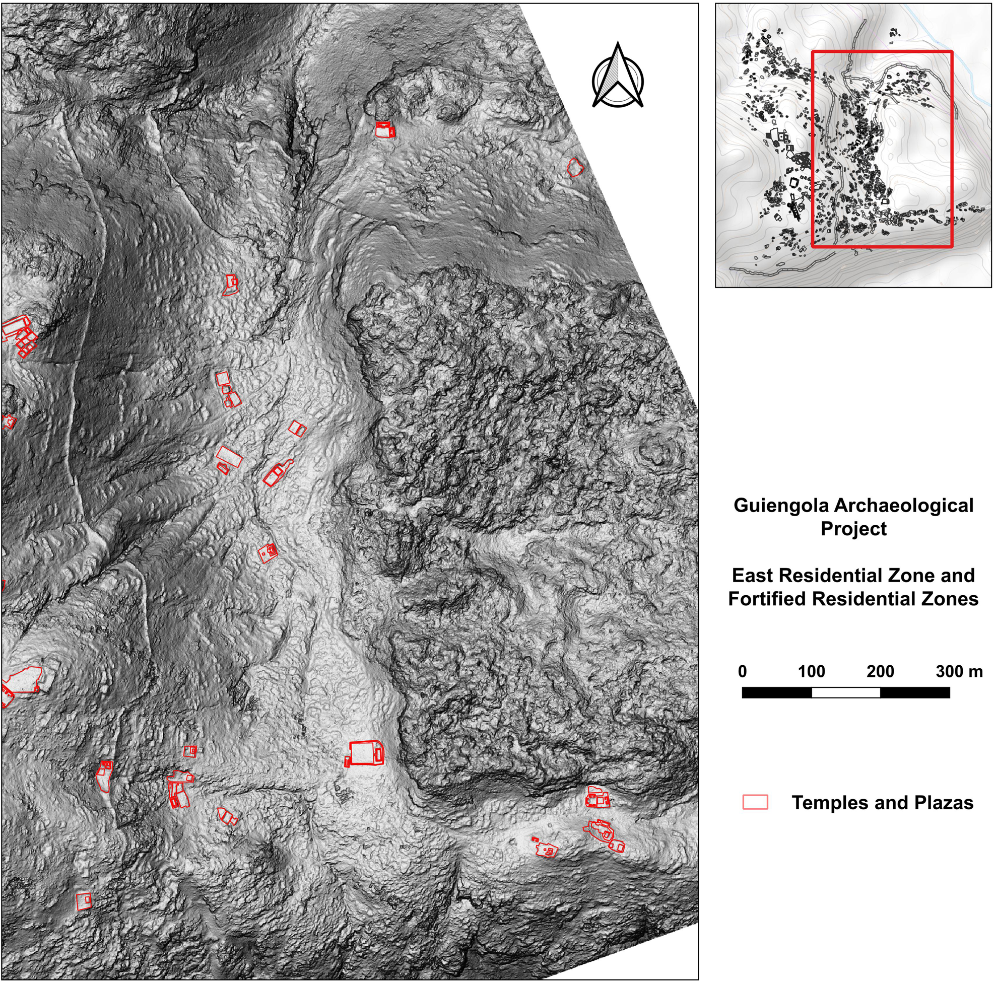
East Residencial Zone. Documented temples and plazas are highlighted.
Residence compound 237 in the East Residential Zone. It is possible to observe how houses grew by extending horizontally, with the addition of patios as needed. Numbers indicate the patios in the compound.

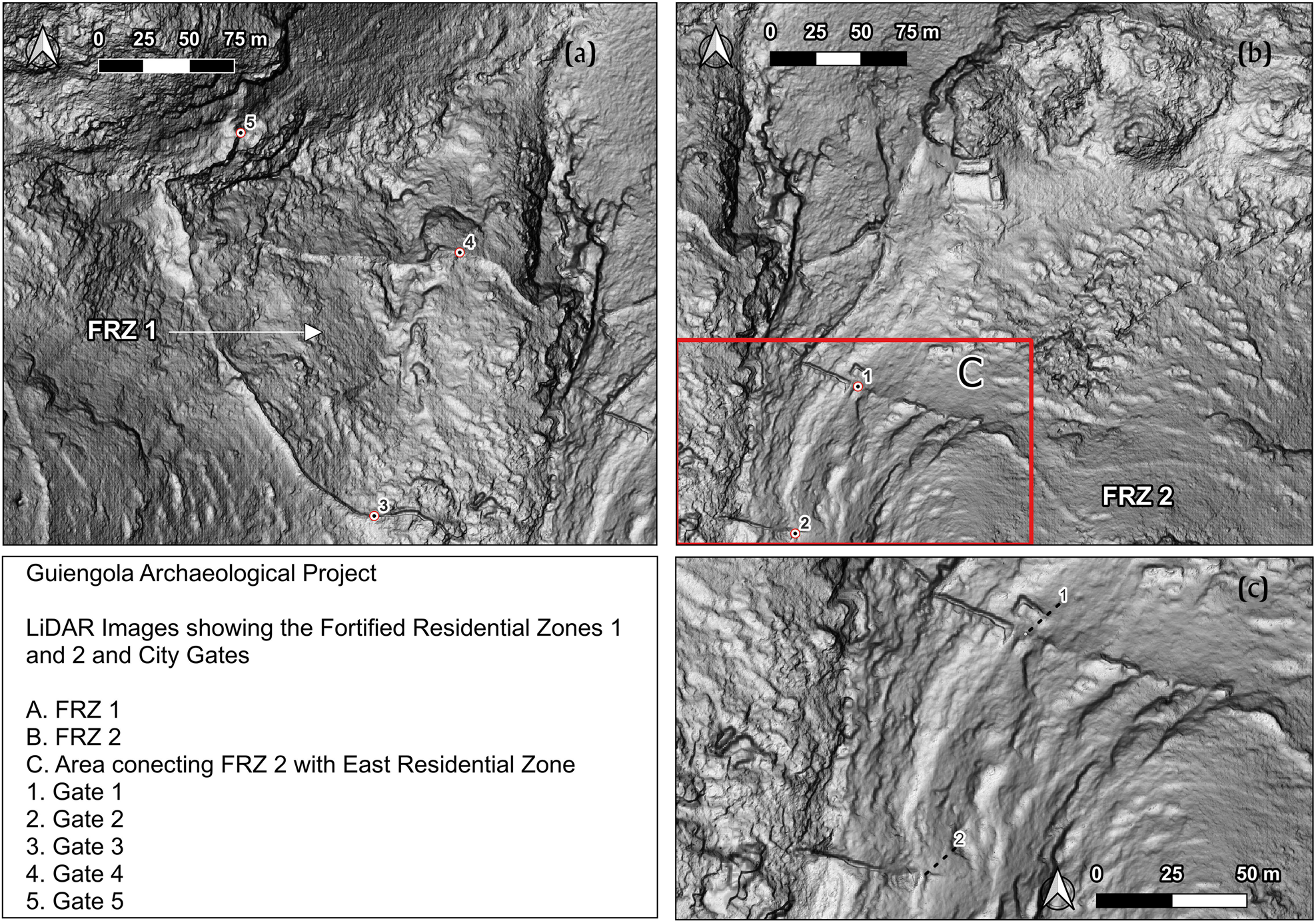
Fortified residence zones, city walls, and gates to access the site.
Guiengola's “Epicenter” (Figure 3) is the zone with the largest constructions and the highest concentration of public buildings, including plazas associated with religious structures such as temple-pyramids and ballcourts. The Epicenter has 104 structures, including two ballcourts, three open plazas, and 15 elite residences, covering approximately 22 ha. Several smaller residential structures within the Epicenter are enclosed by a defensive wall on its east and southern perimeters. These are likely the remains of housing for people who helped to maintain and manage the Epicenter's structures by providing different types of services, such as cooking, cleaning, and ritual caretaking of temples.
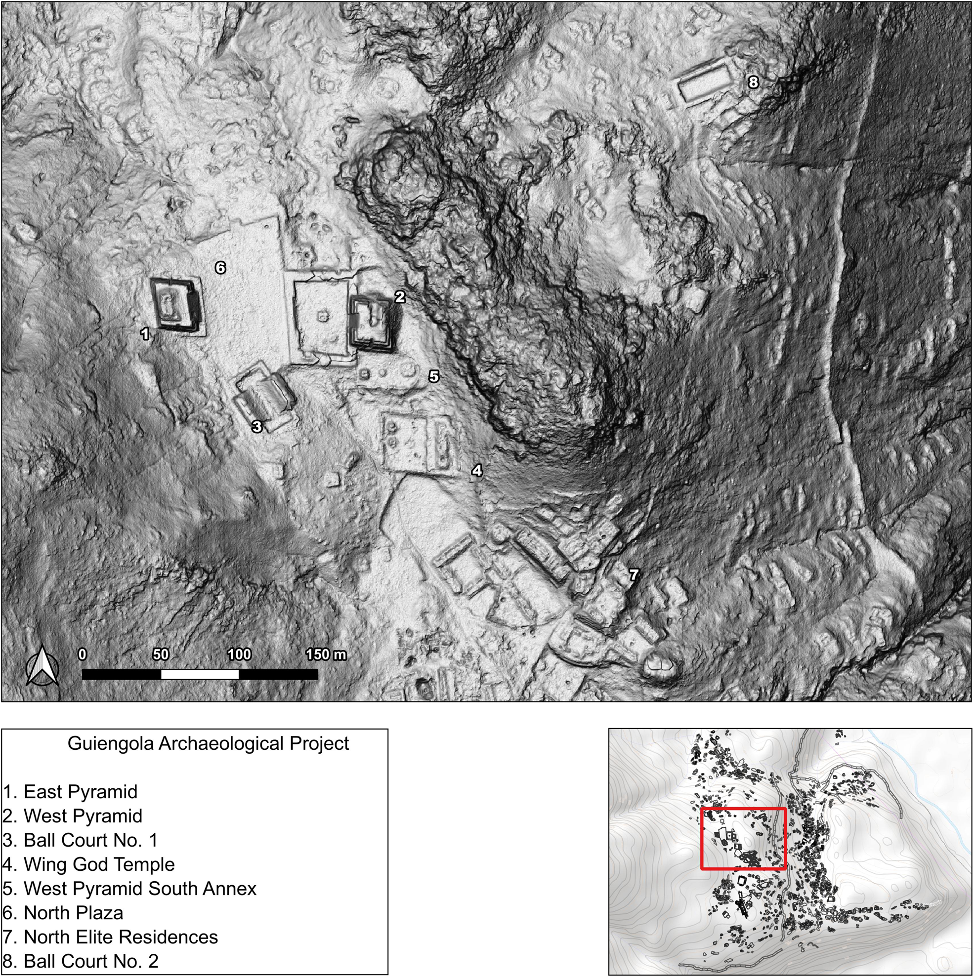
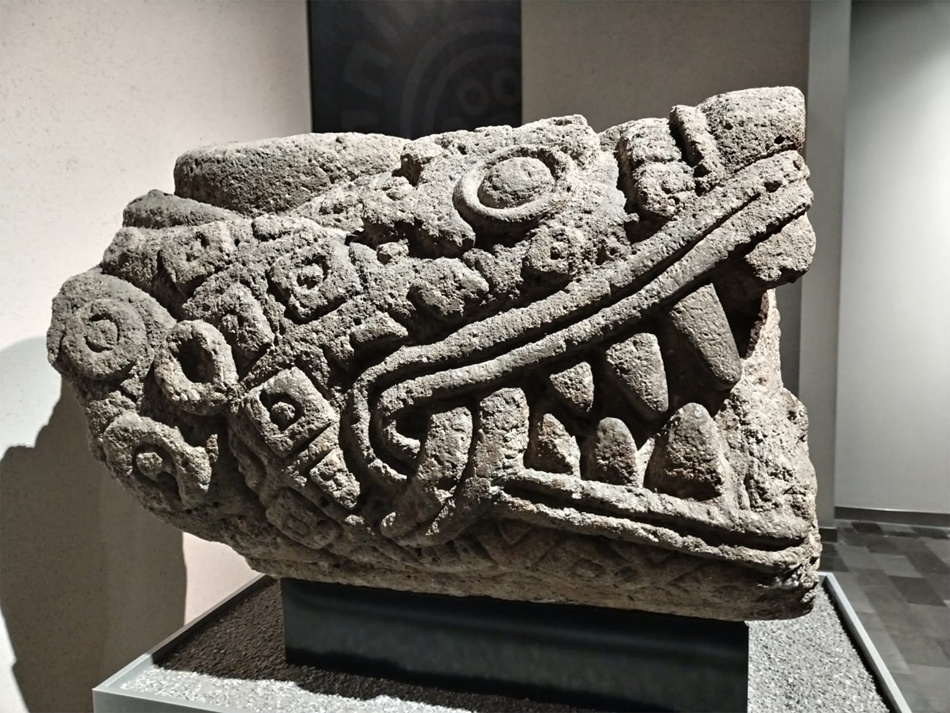
The “Elite Residence Area,” north of the Epicenter (Figure 4), was first registered by Peterson and MacDougall (Reference Peterson and MacDougall1974). Fernández Dávila (Reference Fernández Dávila2021) proposed it as the possible house of the ruler of the city based on Peterson and MacDougall's earlier research. To further differentiate this area from other elite residences, the GAP renamed it the “North Elite Residences.” In the lidar images, one can see a road that connects the elite residences of the Epicenter to the Tehuantepec River, crossing through the “Snake Plaza” (named by Edward Seler because of the presence of a monolith carved in the shape of a snake [Figure 9]) and the South Palace Complex (Figure 3). Also, from the east side of this space, another road connects the residence area with a private ballcourt, Ballcourt No. 2. This road suggests that access to this ballcourt may have been limited to elites. Based on the lidar analysis, one can see how the ballcourt is surrounded by cliffs and natural rocks that impede access to the rest of the city.
Snake sculpture found and described by Seler (Reference Seler1904), now at the Oaxacan hall in the National Museum of Anthropology in Mexico City.
The GAP detected a series of large buildings, thought to be elite residential structures and public plazas in the southern part of the Epicenter, which aligns with Fernández Dávila's findings (Reference Fernández Dávila2021:277). However, after examining our lidar images and the recorded plans done by pedestrian survey, it is clear that these individual structures comprised part of a larger single complex and were not stand-alone buildings. I propose that this complex was the residence and seat of power of Guiengola (Figure 5). Located in the center of the Epicenter, access to the complex is from the north of the Epicenter, through Snake Plaza. The complex covers 2250 m2, measuring approximately 45 m east–west and 50 m north–south, and oriented 14.05 degrees east. The complex has three buildings on its north, south, and east sides. The west side is open to the (ancient) access road.
From this point, if one follows a road 50 m to the south, there is a major elite residence (Figure 5). This residential complex, named “South Palace Complex,” was designed following a northwest–southeast axis. It has a total of nine patios and 24 rooms, and extends on a surface of 6,500 m2. A rectangular plaza and two patios are flanked by buildings designed to receive anyone who arrives by one of the roads that comes from the center of the city. South of the patios is a structure formed by three patios. The GAP detected a sunken square-shaped structure in the center of the northern patio. West of the palace is another square-shaped structure with an inner patio that connects to the palace and is built on the same platform. Protected on its east side by a stone wall and a cliff, the only entry through the wall leads a visitor to a double plaza complex called “Twin Temples.” West of the palace and next to the access road is a house with three big rooms and a patio on a two-story base. The surface materials in this building included a large amount of food preparation vessels, which could have been used by people in service to the elites. Other Zapotec elite houses in Classic Monte Albán, especially those in the Altar House and in the East House of Atzompa, offer notable points of comparison (Robles García and Andrade Cuautle Reference Robles García, Andrade Cuautle, Robles García and Rivera Guzmán2011). These structures are linked through a corridor to the main building, which is composed of four patios aligned from northwest to southeast and connected by a hallway on the west side of the building.
The presence of communal spaces and ceremonial structures within the South Palace Complex at Guiengola implies its function as a gathering point for elaborate feasts and festivities, where the ruling class showcased their wealth and influence. Similar palace complexes have been reported in Late Postclassic Zapotec sites, such as the Palace of the Six Patios at Yagul (Bernal and Gamio Reference Bernal and Gamio1974; Carrillo Bosch and Pacheco Arias Reference Carrillo Bosch and Pacheco Arias2019), the Church group at Mitla (Robles García Reference Robles García2016), and Cerro la Muralla in the Nejapa region (King et al. Reference King, Konwest, Workinger, Badillo and Jarquin2014). According to Carballo (Reference Carballo2011), palatial complexes were used for networking and intermarrying elites of small polities, and their internal complexity reflects the different functions that these structures fulfilled. The central location and size of the South Palace Complex suggests that it played a pivotal role in fostering interregional alliances, serving as a hub where political negotiations, cultural exchanges, and diplomatic engagements took place.
In her extensive research of elite structures in Teotihuacan, Manzanilla (Reference Manzanilla, Charlotte Arnauld, Manzanilla and Smith2012a, Reference Manzanilla and Manzanilla2012b, Reference Manzanilla and Manzanilla2020a, Reference Manzanilla, Hendon, Overholtzer and Joyce2021) emphasizes the importance of understanding the seats of political, economic, and symbolic power through the study of archaeological palaces (Manzanilla Reference Manzanilla2020b). According to the GAP's architectural survey, analysis of surface archaeological materials, and comparison of this information to lidar images, the South Palace Complex was likely a type 3 Palace in the Manzanilla typology (Reference Manzanilla and Manzanilla2020). This type of palace was multifunctional, serving as the seat of government with decision-making and administration functions, as well as the residence of the nobility.
Spatial differences in Guiengola clearly mark distinctions between elite and commoner areas. The previously mentioned five additional residential zones located to the north and east of the Epicenter (Figure 2) are named Epicenter Residential Zone, North Residential Zone, East Residential Zone, Fortified Residential Zone No.1, and Fortified Residential Zone No.2. They are separated by the main wall of the site on the east of the Epicenter, and by the end of the platform that supports the North Plaza. Furthermore, the Epicenter was constructed on higher ground than the rest of the site, which spreads north and east not just outside its walls but also below it. These separations and the fact that the distribution of architecture between these zones was not homogenous indicates that there were social divisions.
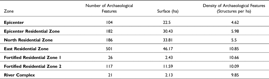
In addition, the GAP analyzed the settlement patterns of Guiengola, such as the size of the residential structures and the density of constructed space. A density analysis (Table 1), based on the calculation of the number of structures identified per hectare, shows that even if the East Residential Zone and the Fortified Zones differ in the number of constructions, the number of buildings per hectare is quite similar: close to 10. The North Residential Zone and the area that surrounds the Epicenter share a similar value of 5.9 and 5.6 buildings per hectare. The lowest number of structures per hectare is in the Epicenter (4.6 buildings per hectare), which is also the zone with the largest buildings. The GAP also took open spaces into account when analyzing the urban layout. The construction density was calculated based on the number of buildings per hectare rather than square meters of the constructed area, given that it has been suggested that formal public space—such as plazas—functioned as public goods (Norwood and Smith Reference Norwood and Smith2022) and were meant to be part of the city.
Guiengola zones and construction density
Of special interest to the GAP is the East Residential Zone (ERZ) (Figure 6), because a significant number of buildings were detected there, and it is where most of the city's population lived. A total of 501 structures have been identified in this space, from small terraces to complex residential structures with several patios and attached smaller structures. Of these constructions, 14 structures have associated plazas and are probably small temples. These temples and plazas are located immediately adjacent to residential constructions.
The topography of the ERZ played a significant role in determining the buildings’ arrangement, given that the residences and temples clearly follow temporal streams and drainage patterns. Situated alongside a sporadic stream that stretches for 750 m, the East Residential Zone is approximately 50 m lower in elevation than the North Plaza. The stream runs from the southern part of the ERZ, where a cliff 400 m in height separates Guiengola from the coastal plain of the Isthmus all the way to the Tehuantepec River in the northeast of the city. The different residential compounds were separated from one other by the relatively flat surfaces, with no vegetation caused by water drainage. Given that water flowed only when it rained, the drainage areas were dry most of the year, suggesting they were a clear mechanism for creating boundaries between houses and were also used as paths and roads.
The ERZ is well connected with both the exterior and interior of the city because the main road of the site, which connects the city with the river and with the Epicenter, crosses it. Most of the major residences in this zone were found adjacent to this road. An example of this is Compound 237, with eight patios and 17 rooms, as well as a second residential structure with seven patios and nine rooms attached (Figure 7).
The GAP compared the ERZ to the North Residential Zone (NRZ) and found notable differences in both construction density and layout (Figure 2). Analysis of the 35 buildings surveyed in the NRZ in comparison to the 44 buildings surveyed in the ERZ shows that the buildings in the ERZ have multiple patios, whereas most in the NRZ have only one. This may suggest that the people in the ERZ had lived there longer and built new patios with each successive generation, similar to the building pattern of houses described at Seibal (Tourtellot Reference Tourtellot, Richard and Ashmore1988). By contrast, the people in the NRZ may have only lived there for one generation. Additionally, the lower construction density and the fact that residences are not next to each other in the NRZ may indicate that the area was populated for a shorter period of time compared to the ERZ. This hypothesis needs further development with more artifact and construction material analysis, given that other possibilities such as class or ethnic differences could explain the variance between the residential structures of these two zones.
The people of Guiengola developed an intricate system of walls that covered the primary point of entry to the settlement. In the northeast corner of the city are two zones with exterior defensive walls identified by the GAP. Fortified Residential Zones (FRZ) 1 and 2 are surrounded by defensive walls (Figure 8), and roads connect them with the other residential zones to the south and with the exterior of the site to the northeast. This made these two zones the most vulnerable to an external threat during moments of conflict. FRZ 1 is located the farthest north and is therefore the most exposed. None of the structures in FRZ 1 appear to be temples or elite residences, suggesting that most of the city's elites lived in better protected areas. Yet, here the defensive walls are built the highest, with some sections still standing as tall as 5 m. The walls have two gates facing the Tehuantepec River, although the road to these gates is now very steep and difficult to traverse.
In contrast, FRZ 2 has a flat and easy entry point from the Tehuantepec River. Proximity to the river and the GAP's archaeological reconnaissance of this zone indicate that the road starts at a terrace next to the riverbank, passes in front of the only monumental structure of FRZ 2, and then continues south through two gates embedded in the walls that protect the ERZ (Figure 8). The road was designed with the walls in mind, given that it zigs zags across these two zones. The gates are guarded by square structures built into the walls, so it is possible that there were checkpoints to control who entered the city. The road proceeds through the ERZ, passing between a series of large residences and temples. Then the road climbs the hill that supports the Epicenter, crossing another gate at the wall that encloses the Epicenter before it reaches the middle of the North Elite Residence (Figure 2). The structures of the North Elite Residence were built around this stone-slab paved road.
Guiengola and urbanism in Oaxaca
The archaeological site of Guiengola offers a unique opportunity to study the living conditions of Zapotec commoners during the Late Postclassic period. This research revealed an urban center that was not previously documented as part of the political network of Late Postclassic Mesoamerica. Based on the GAP's extensive and ongoing research, I assert that accurately classifying this settlement as a city instead of a fortress enriches our understanding of the diverse sociopolitical landscape of southern Mesoamerica, and the process of expansion, conquest, and colonization of the Isthmus of Tehuantepec by the Zapotecs. In addition, it expands our knowledge on how the people moving from the Central Valleys to the southern Isthmus of Tehuantepec adapted to the environment of its Pacific tropical plains.
Archaeologists have defined cities as places where people and activities are concentrated. They explain that urban areas are hubs of economies and politics that provide a platform for the creation of institutions and processes that impact entire societies. Simultaneously, they are settings for social problems, such as poverty, inequality, and inadequate access to infrastructures and resources (Ortman et al. Reference Ortman, Lobo and Smith2020; Smith Reference Smith2013). All of these attributes are concentrated in space, making cities complex and impactful in shaping the landscape. Michael Smith (Reference Smith2023) emphasizes that the terms “urban” or “city” are analytical units that are used to designate particular characteristics of a settlement, and that the settlement itself should be the primary unit of analysis.
In this context, Guiengola exemplifies these qualities as a clustered settlement with evidence of diversified activities. Documented architecture shows that the site served as a strategic location for the Zapotec elite, facilitating alliances in their elaborate residences, ballcourts, and plazas, in addition to providing shelter against external threats. Furthermore, the city's layout is defined by its extensive residential areas, which demonstrate the intertwining of centralized authority with commoner organization.
Now it is possible to compare this settlement with the robust corpus of scholarly work focused on internal city organization in Mesoamerica, most of which is focused on Classic central Mexico, especially in Teotihuacan (Carballo et al. Reference Carballo, Hirth, Sariñana, Buckley, Ramón and Kennett2019; Manzanilla Reference Manzanilla, Charlotte Arnauld, Manzanilla and Smith2012a, Reference Manzanilla, Hendon, Overholtzer and Joyce2021; Millon Reference Millon1970; Rattray Reference Rattray, de Tapia and Rattray1987; Smith Reference Smith2017; Smith et al. Reference Smith, Chatterjee, Huster, Stewart and Forest2019; Storey et al. Reference Storey, Morfín, Nuñez, Charlotte Arnauld, Manzanilla and Smith2012), or the Maya region (Burham Reference Burham2022; Chase et al. Reference Chase, Lobo, Feinman, Carballo, Chase, Chase, Hutson, Ossa, Canuto, Stanton, Gorenflo, Pool, Arroyo, Stuardo and Nichols2023; Hutson and Welch Reference Hutson and Welch2021; Thompson et al. Reference Thompson, Meredith and Prufer2018; Thompson et al. Reference Thompson, Walden, Chase, Hutson, Marken, Cap, Fries, Rodrigo Guzman Piedrasanta, Hare and Horn2022). These studies show how Mesoamerican cities often featured advanced engineering, monumental architecture, complex social hierarchies, and sophisticated religious and astronomical knowledge, and how they were part of a process of urbanization belonging to a larger Mesoamerican urban tradition (McCafferty and Peuramaki-Brown Reference McCafferty and Peuramaki-Brown2007).
Cities in Mesoamerica were centers of trade, culture, and political power in their respective time periods. Guiengola exemplifies how these urban features were adapted to the unique cultural and political landscape of the southern coast of Mesoamerica, revealing its role as a center of trade, culture, and power—comparable to urban centers of central Mexico and the Maya region. One of the best comparisons for understanding the origins and functionality of Guiengola is Mayapan, a fortified urban center in the Yucatan peninsula, likely established by a migrant population in a hostile political environment (Hare et al. Reference Hare, Masson and Russell2014; Masson Reference Masson, Hendon, Joyce and Overholtzer2021). Guiengola was constructed in a landscape populated by other groups with a rich history of human habitation in the area: Zoques, Mixes, Chontales, and Huaves (Winter and Sánchez Santiago Reference Winter and Sánchez Santiago2014). The defensive structures around Guiengola, protecting not only its Epicenter but also its entire population, imply that similar to Mayapan (Russell Reference Russell2013), the primary purpose of these walls was to safeguard its residents from external threats coming from these groups that the Zapotecs were displacing. Additionally, the fortifications served a secondary function of regulating the movement of people and goods within the city, symbolizing a barrier between different social classes.
The Isthmus of Tehuantepec is often studied in relation to urbanized areas such as the Central Valleys of Oaxaca, where several urban centers exercised political control over this territory. The ruling elite from these cities viewed the Isthmus as a place to gather resources and as a trade route. Addressing the presence of an urban center with evidence of political hierarchy and social complexity at the scale observed in Guiengola suggests that the people in the Isthmus also played a significant role in shaping the political landscape of Mesoamerica's southern highlands during the Late Postclassic period, which indicates that they were not just passive actors in external political decisions.
This long-distance relationship can be observed by comparing the architecture of two notable Zapotec Postclassic cities: the Palace of the Six Patios in Yagul (Bernal and Gamio Reference Bernal and Gamio1974), and Mitla's Church Group (Robles García Reference Robles García2016) located in the Tlacolula region of the Central Valleys. Paddock (Reference Paddock1954), Carballo (Reference Carballo2011), and González Licón (Reference González Licón, Evans and Pillsbury2004) have observed similar patterns in the distribution of the private and public space in these structures. Each of the patios of these buildings consists of an open space limited by a banquette and corridor, with four major rooms on their sides. These rooms have only one door facing the patio, most of which have two columns. These patios are interconnected through a series of hallways, allowing communication between all of them. These buildings have restricted points of entry, implying that there were degrees of accessibility and privacy within them. Whereas some patios have open spaces for traffic and may have been designed for social purposes, other patios require passage through narrow corridors to promote privacy for the family that lived there (Bernal and Gamio Reference Bernal and Gamio1974; Paddock and Bernal Reference Paddock and Bernal1966).
The South Palace of Guiengola, like the Palace of the Six Patios and the Church Group, features a series of interconnected patios and hallways (see Figure 10). The buildings share similarities in the organization of private and public spaces, suggesting a similar function as the residence of the ruling family and as the seat of power on the site. In Guiengola, this design allows for a seamless flow of circulation from the open and public spaces in the north patios to the more intimate and private spaces in the southern patio of the structure. This pattern indicates a strong connection between the royal families who governed these sites. The recognition of a ruling family in Guiengola, that was able to gather resources to build a structure similar to the elite residences in Yagul and Mitla, can provide insights into the alliances and power dynamics that characterized the Zapotec migration to the Isthmus of Tehuantepec in the fourteenth and fifteenth centuries. Guiengola expands our understanding of the network of alliances between polities in the Central Valleys, through the Sierra Sur, and into the Isthmus.
(a) South Palace in Guiengola, (b) Church group in Mitla, (c) Palace of the six patios in Yagul. Images (b) and (c) were drawn by González Licón (Reference González Licón, Evans and Pillsbury2004).

There is also an ample body of scholarship in Oaxacan archaeology on urban organization and the development of social complexity. Important research on the development of urbanism in Oaxaca include sites such as San José el Mogote, Tierras Largas, Tomaltepec, and Monte Albán, where archaeologists have documented how urban settlements evolved, leading to the emergence of social inequality, the specialization of ritual practices, and the creation of elites (Blanton Reference Blanton1978; Flannery Reference Flannery and Flannery1976; González Licón Reference González Licón2011; Joyce Reference Joyce, Browser and Nieves2009, Reference Joyce, Overholtzer and Joyce2021; Marcus et al. Reference Marcus, Escofet and Rodríguez2008; Redmond and Spencer Reference Redmond and Spencer2017; Spencer Reference Spencer2010; Winter Reference Winter1972). Beyond the Central Valleys, the development of urbanism has also been examined in the Mixteca region at sites such as Cerro Jazmín (Pérez Rodríguez Reference Pérez Rodríguez2011, Reference Pérez Rodríguez2015; Pérez Rodríguez et al. Reference Pérez Rodríguez, Kellner and Ponce de León2020), Monte Negro (Balkansky et al. Reference Balkansky, Pérez Rodríguez and Kowalewski2004), Yucuita, and Huamelulpan (Spores Reference Spores2018). Guiengola, in this regard, represents a final chapter in the long history of social complexity among the people living in the southern highlands of Mesoamerica, continuing the trajectory of urban and political development seen in the first Zapotec urban centers. The city's strategic defensive architecture, religious and elite structures, and the residential neighborhoods reflect the ongoing sophistication of Zapotec society and its ability to adapt to new challenges and opportunities. However, they also indicate that social inequality, dominance, and exploitation remained in the fabric of Zapotec society by the time of the European contact.
Guiengola social organization and political role in the Isthmus of Tehuantepec
Archaeologists have acknowledged the significance of analyzing neighborhoods as a social and spatial unit in Mesoamerican cities (Arnauld et al. Reference Arnauld, Manzanilla and Smith2012; Feinman and Nicholas Reference Feinman and Nicholas2004, Reference Feinman, Nicholas, Charlotte Arnauld, Manzanilla and Smith2012; Manzanilla 2012; Rattray Reference Rattray, de Tapia and Rattray1987; Smith and Novic Reference Smith, Novic, Charlotte Arnauld, Manzanilla and Smith2012). Moreover, studying Postclassic cities allows for comparing archaeological evidence with historical analyses of Indigenous social organizations. Recognizing Guiengola as a city rather than just a fortress, as I have argued, also enables the discussion of certain aspects of its social complexity.
The ethnohistorian Fernández Christlieb (Reference Fernández Christlieb2015) stresses the importance of analyzing both archaeological and historical records for understanding urbanism in the Postclassic period. He uses the concept of altepetl, which differentiates the study of the Postclassic period from other moments of Mesoamerican history because it provides a historical reference to understand how Indigenous people in Mesoamerica conceptualized urban life. Bernal and Garcia Zambrano (Reference Bernal García, García Zambrano, Christlieb and Zambrano2006) explain that, rather than being synonymous with a “town” or a “city,” an altepetl is a form of Indigenous spatial organization along kin relationships, mythic-aesthetic attributes of the landscape, and functionality.
Gutiérrez Mendoza (Reference Gutiérrez Mendoza, Daneels and Mendoza2012) expands their discussion, arguing that there is a methodological error in conceptualizing altepetl as a compound of settlements tied together in hierarchical organization, or as the relationships of power between lords and their subjugates. Instead, he contends that the altepetl is organized around horizontal ties between kin and allies. A main unit in the composition of the altepetl is the barrio, or calpulli in Nahuatl. This is a kin-based, hierarchically organized group of people who lived together, shared land, had a shared identity, and provided communal labor in the service of altepetl necessities (Overholtzer Reference Overholtzer2021; Smith Reference Smith2010; Soustelle Reference Soustelle1970; Zeitlin Reference Zeitlin2005).
In this regard, it is possible to understand Guiengola beyond the Western concepts of city or town, which analyzes cities as a hub of interactions and institutions. Instead, the city exhibits evidence of important aspects of Indigenous spatial organization in its settlement pattern. This urban setting makes it possible to consider how the city formed an intricate network of loyalties based on kin relationships. The documentation of 16 plazas and the residential buildings distributed over the settlement are a good example of the functioning of Indigenous institutions such as the barrio or calpulli in the fifteenth century.
Ethnohistorians working in Oaxaca have examined urban organization in the sixteenth century in the town of Tehuantepec, which was the largest settlement inhabited by Zapotecs in the Isthmus at the time of the Spanish conquest, and whose current inhabitants own the lands where Guiengola is located (Oudijk Reference Oudijk2000, Reference Oudijk2008, Reference Oudijk2019; Zeitlin Reference Zeitlin, Marcus and Zeitlin1994, Reference Zeitlin2005, Reference Zeitlin, Alexander and Kepecs2018). Zapotec social organization in Tehuantepec was based on its households—or yoho—which, like the calpulli, were also autonomous kin-based institutions. Yoho were typically organized around the house, or the buildings used by people as dwellings, constituted by a patio surrounded by rooms. Here, extended families cohabited and reproduced. As families grew, the number of rooms around each patio increased accretionally, and if necessary, an extra patio was built. New patios were often built alongside old ones, but even when patios were built in a new location, the people residing there were still considered to be connected to the original family group. This is parallel to the Tourtellot (Reference Tourtellot, Richard and Ashmore1988) analysis of the growth of residential buildings in Seibal. Each yoho was governed by its own lord, and it had its own palace, public spaces, religious buildings, and constituent members.
Identifying this form of social organization in Guiengola allows for a more comprehensive study of the economic, social, cultural, and administrative aspects of Zapotec society prior to European contact. Moreover, the documentation of extensive commoner spaces in the city, as the GAP is doing, help us to address the social and political organization of the city. Even though houses are irregularly spaced, evidence of distinct neighborhoods, or yoho, can be seen in the presence of temples and plazas surrounded by clusters of houses. These features can be linked to ethno-categories of social organization such as yoho, or altepetl from sixteenth-century studies, connecting the archaeological record to historical social practices. In Guiengola, the houses are not arranged in a grid, as they are in Teotihuacan or Tenochtitlan. Instead, the people who constructed them took advantage of the terrain to satisfy the needs of the yoho, providing communal labor to construct and modify their environment. When members of the ruling class needed to build a monumental project—such as a temple in the Epicenter, a new walled area, or a palace—they could request the required communal labor from the various yoho.
The GAP has produced the first complete map of Guiengola, revealing a city that was experiencing continuous expansion and development for more than a century before Tehuantepec was established as the capital of the Zapotec people in a.d. 1440. This growth was most likely fueled by a consistent influx of migrants from the Central Valleys. I argue that this urban expansion is evident in areas such as the East Residential Zone, which had the highest number of residential and public structures, and the highest occupational density. In contrast, other spaces such as the North Residential Zone had fewer constructions and public buildings, and structures there generally had fewer patios—the latter indicating that fewer generations inhabited this zone.
The analysis of lidar imagery and mapping of Guiengola helps us understand the ways in which people living in the city transformed or adapted construction with respect to the topography of the mountain. This was something that previous projects, including the GAP systematic surveys from 2018 to 2022, had not considered. It is clear that parts of the city were built to take advantage of the mountain's geographic features, such as slopes, drainages, hills, rock outcrops, and cliffs. The South Palace Complex, for example, is protected by a rock formation along its east side, and the residential compounds are agglutinated between the seasonal arroyos in the East Residential Zone. Both are excellent examples of architectural accommodations that were enhanced by or specifically adopted because of existing natural landscape features.
The analysis in this article profoundly changes our comprehension of the urban dimension and demographic patterns of the Late Postclassic Isthmus of Tehuantepec. The traditional model established that around a.d. 1370, Cosijoeza 11 Water, ruler of Zaachila, started the Zapotec incursions into the Isthmus of Tehuantepec, founding several towns such as Guevea and Jalapa. It was not until the 1440s that Cocijopii I, a later ruler of the Zaachila dynasty, permanently moved the seat of government to Tehuantepec, erecting Guiengola as a fortress to defend against the hostilities of advancing Postclassic powers, especially the Mexica armies (Winter and Sánchez Santiago Reference Winter and Sánchez Santiago2014).
My findings with the GAP indicate that Guiengola was a political capital, with a tremendous amount of labor invested in its planning and construction, including palaces for its rulers, and a complex social organization. Furthermore, my findings show that Guiengola had the political institutions necessary for an autonomous polity, complex elite residences, and administrative buildings, like the South Palace Complex; this indicates that the population had its own noble hierarchies loyal to their own lords. Additional research into the power dynamics between Zaachila, Guiengola, and Tehuantepec can help us understand whether there was a Late Postclassic Zapotec State (Ramón Celis et al. Reference Ramón, Guillermo, Ayala and Fuentes2024), or if there was a coalition of “Petty Kingdoms,” as Kowalewski and his collaborators proposed (Kowalewski et al. Reference Kowalewski, Feinman, Blanton, Nicholas and Finstein1989). This state or confederation spread its control of the territory through various semi-autonomous towns with their own nobility (Figure 11), including Guiengola, Mitla, and Yagul, and other fortified sites in the Sierra Sur, such as Cerro del Convento in the Nejapa region (King et al. Reference King, Konwest, Workinger, Badillo and Jarquin2014).
Expansion of Zapotec settlements during the Postclassic period. Territories under Zaachila and Tehuantepec control, according to Burgoa Reference Burgoa1989 [1674] and the Relaciones Geograficas de Tehuantepec, Nejapa and Teozapotlan in Acuña (Reference Acuña1984).

The analysis of the urban layout of the city suggests that Guiengola was possibly constructed as a place to organize the conquest and colonization of the Pacific Coast by Zapotec rulers. This explains why the city was surrounded by cliffs and walls, given that it was probably an important target for any resistance from the displaced people of the Isthmus. It also implies that the conquest of the region was not a single event with masses of people fleeing the Central Valleys and destroying everything in their path. On the contrary, the conquest and colonization of the Isthmus was a process that extended for generations and could have lasted over 100 years, from a.d. 1350 to 1460. Furthermore, far from only being a space constructed and planned by Zapotec lords according to their plans for conquest and colonization, Guiengola was a space where commoners created and transformed the mountain to adapt their communities to this new home. My examination of the public spaces within the city exposes a pattern of people seamlessly integrating their residences, plazas, and small temples with the surrounding mountainous terrain, which gave rise to areas of socialization that facilitated face-to-face interactions. This, in turn, encouraged a dynamic social environment, in which individuals shared ideas and influenced one another to create spaces that complemented the rigid and planned elite spaces of the Epicenter.
Conclusion
The GAP has gained valuable insights of the intricate details of the Mesoamerican Postclassic city of Guiengola. The research presented in this article expands our understanding of the unique ways commoners constructed their neighborhoods, and the significant contrasts between residential zones and the city's Epicenter. Similar to barrio or yoho organization in sixteenth-century Tehuantepec, people in Guiengola followed communal practices focused on the well-being of their extended families. The presence of 16 plazas and small temples outside the Epicenter indicates the existence of this pattern of organization. The presence of such yoho suggests that commoners were not simply followers of the desires of high-ranking nobility; instead, communal decision-making played an important role in the design, growth, and modification of living spaces in Guiengola.
The discovery and identification of administrative spaces such as the South Palace Complex reveals that Guiengola was a key actor within Late Postclassic politics and was instrumental in the Zapotec expansion and conquest of the Isthmus of Tehuantepec. Addressing the role of Guiengola's rulers in this process increases our knowledge about the strategies used by the Zapotec elites in the Postclassic period, especially with respect to their relationship to other polities such as the Mixtec kingdom of Tututepec or the Triple Alliance of Tenochtitlan, Texcoco, and Tlacopan, who attacked Guiengola in a.d. 1497.
The research of the GAP enhances our understanding of the intricate social, political, and economic dynamics between the elite and commoner barrio organizations in Late Postclassic Mesoamerica. The project also helps to understand similarities and continuities with barrios during the Colonial period, which can lead to further investigations and expand our knowledge about how Mesoamerican settlements transformed after the European contact.
Acknowledgments
This research was made possible by the generous financial support of the Wenner-Gren Foundation (Gr. #10341), the Tinker Foundation Field Research Grant, and the Indiana University College of Arts & Sciences Dissertation Research Fellowship. I also thank the Consejo de Arqueología from the National Institute of Anthropology and History for granting the permissions for the 2018, 2021, and 2022–2023 field seasons. I extend my deep gratitude to the three anonymous peer reviewers, whose insightful feedback helped to refine and polish the ideas and images presented in this article. A special thanks to Araby Smyth for her invaluable assistance with the English edition. I am also immensely grateful to the people of Barrio Lieza in Tehuantepec, the custodians of the archaeological site, and the Zapotec collective Gopayoo for their crucial role in the logistics of this research. Finally, I would like to acknowledge the hard work and dedication of the Guiengola Archaeological Project crew members: Alberto Soto Fuentes, Itzel Chagoya Ayala, Jesse Romo Santiago, Magdalena Romo Santiago, Noe Garnica, and Raúl Calderon.


 Open access