Introduction
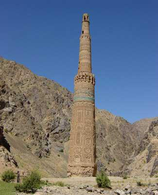
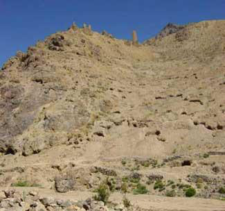
The Minaret of Jam (Figure 1) has been the focus of conservation and research for over 45 years (Reference BrunoBruno 1979; Maricq & Wiet 1959; Reference Sourdel-thomineSourdel-Thomine 2004). In 2002, UNESCO declared Jam Afghanistan's first World Heritage Site - in addition to being the site of the Minaret, Jam is probably Firuzkuh, the Ghurid summer capital (Reference VercellinVercellin 1976). The Minaret is merely the most visible element of the surrounding rich archaeological heritage, which largely remains uninvestigated (Figure 2). As the preliminary field season of the MJAP discovered, the subterranean archaeology is also under threat, from looting, erosion and planned infrastructure improvements (Reference ThomasThomas 2004).
The Minaret of Jam - at 63m high, the second tallest mud-brick minaret in the world.

Qasr-e Zarafshan and 'Bazaar' area, on the north bank of the Hari Rud - the tallest surviving mud-brick tower in Qasr-e Zarafshan stands over 80 courses high.

Geographical and Historical Setting
Location of Jam - Landsat Image courtesy of Dr Kevin White, University of Reading.

Jam is located in the Ghur province of western Afghanistan, an inaccessible, mountainous region c. 200km to the east of Herat (Reference BallBall 1982: 133; Figure 3). The geographic isolation and harsh, impoverished environment has had a profound influence on the historical and cultural developments in Ghur. Their neighbours regarded the Ghurids as little more than petty chieftains and mountain brigands (Reference BosworthBosworth 1961: 121-123) and their isolation and independent streak still results in periodic tension.
The Ghurids (c. AD 1148-1222) first rose to prominence through their struggles with the Ghaznavid and Seljuq empires. The Ghaznavids launched expeditions into Ghur in the early eleventh century, and in doing so, introduced Islam to the previously pagan local inhabitants. Although not pacified, Ghur became a strategically significant buffer zone as the Seljuq empire to the west expanded (Reference BosworthBosworth 1977: 68).
The Ghurids' response in c. AD 1150 was emphatic and culminated in the 7-day sack of Ghazna, earning the Ghurid commander cAla' ad-Din Husayn the sobriquet Jahan-Suz or 'Incendiary of the World' (Reference BosworthBosworth 1977: 117). The Ghurid empire expanded greatly under the brothers Ghiyath ad-Din and Mucizz ad-Din (the former's inscription is found on the Minaret of Jam - Reference KiefferKieffer 1960). Their armies occupied Herat in 1175 and by 1200 had taken Nishapur (in present day Iran) and the former Seljuq capital of Merv (now in Turkmenistan). In the east, Mucizz ad-Din led incursions into India, conquering Sind in 1182 and occupying Delhi in 1192; Ghurid banners were even carried into Bengal.
Ghurid fortunes declined, however, following the death of Ghiyath ad-Din in 1202 and Mucizz ad-Din's assassination in 1206. Khwarazm armies extinguished the Ghurid dynasty in Afghanistan in 1215 (Reference NizamiNizami 1998: 184), before Mongol armies under Ghengis Khan completed the destruction in 1222.
Fieldwork in 2003
The Istituto Italiano per l'Africa e l'Oriente (IsIAO) conducted a short, preliminary season of archaeological fieldwork at Jam in August 2003, on behalf of UNESCO and the Afghan National Institute of Archaeology (Thomas et al. in press). The principal aims of the season were:
-
• to provide an archaeological impact assessment of the proposed route of the road.
-
• to investigate the nature of archaeological deposits near the Minare.
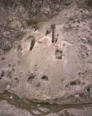
We limited our work to surface collection and re-excavating robber holes, so as to minimise our impact on the site (Figure 4). Unsurprisingly, the deposits along the proposed route of the much-needed road and bridge were highly disturbed. Our excavations, however, yielded a wide range of ceramics, including glazed sgraffiato wares. We also recovered pieces of stucco, fine painted wall plaster and a couple of small coins, the better preserved of which is Seljuk in origin and has been dated to the early twelfth century. Although limited, these finds indicate the import of luxury items, a relatively high standard of living and concern for aesthetics amongst the inhabitants of Jam.
Robber holes on the west bank of the Jam Rud (photograph taken from the Minaret, during MJAP excavations).

Large, heavily burnt, baked-brick wall in the south bank of the Hari Rud, near the Minaret.

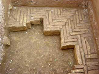
'Herring-bone' pattern baked-brick paving found in a robber hole near the Minaret.

The results of work near the minaret were more informative. Juzjani, the principal source for the Ghurids, states that the Friday mosque at Firuzkuh was destroyed by a massive flood (cited in Reference Pinder-wilsonPinder-Wilson 2001: 167). Exploration along the banks of the Hari Rud revealed a 10m stretch of baked-brick wall, at least 9 courses high and 0.7m wide (Figure 5). We also exposed a 3.5m long stretch of baked-brick paving in the river bank, beneath c. 1.05m of alluvium. More, well-preserved paving was found in another robber hole nearby (Figure 6). Comparable paving has been found in the Ghaznavid Mascud III Palace at Ghazna (Reference ScerratoScerrato 1959: 30-32) and at Lashkari Bazar (Reference SchlumbergerSchlumberger 1978: 30-31 pl. 59-61).
Conclusions
The potential and urgent need for further archaeological work at Jam is clear, particularly in the light of the extensive looting. The exposed baked-brick wall and paving, and their proximity to the minaret, provide tantalising evidence of a large, high-status building, possibly the mosque Juzjani refers to. In future seasons, we hope to conduct geomorphological and geo-physically surveys and targeted test-pitting to the east of the minaret to 'ground-truth' the survey results. Such work would hopefully define the nature and extent of the courtyards and the major building associated with the Minaret of Jam.
Acknowledgments
The Minaret of Jam Archaeological Project is directed by Prof. Verardi, of IsIAO, and is generously funded by UNESCO. We are indebited to our Afghan colleagues and hosts for the warmth of their welcome and their efforts to facilitate our work. Gulham Naqshband Rajabi (archaeologist and Afghan representative of IsIAO), Mr Abdul Wassey Feroozi, former Director of the National Archaeological Institute of Afghanistan, and Mr Najeeb Ahmed Sidiqi, our representative, deserve particular mention. We are also very grateful to His Excellency Mr Raheen, the Minister of Information and Culture for his assistance, as well as to Mr Jim Williams and Ms Frozan Nabiyar, of UNESCO in Kabul.