
Introduction
The island of Sardinia has been renowned for the quality and quantity of its agricultural production since Classical Antiquity. The island's grain exports famously helped Carthage to fund its mercenary armies between the fifth and third centuries BC and thus maintain its dominant position in the western Mediterranean. It is on the basis of these assumptions that exploitation of both agricultural and mineral resources has long been recognised as a cornerstone of the Carthaginian colonial network of overseas Punic territories (e.g. Reference LancelLancel 1995: 81-3).
In the past decade or so, archaeological investigations of rural districts in the various Punic regions of the western Mediterranean, most notably in southern Sardinia and Ibiza, have begun to bring to light a wealth of evidence that may be associated with rural settlement and agricultural exploitation. One of the areas investigated is the Terralba district on the central west coast of Sardinia, where a remarkably dense cluster of numerous small to medium-sized rural settlements has been recorded as dating to the Classical and Hellenistic periods (Reference van Dommelenvan Dommelen 2003; Reference van Dommelen2006; Figure 1).
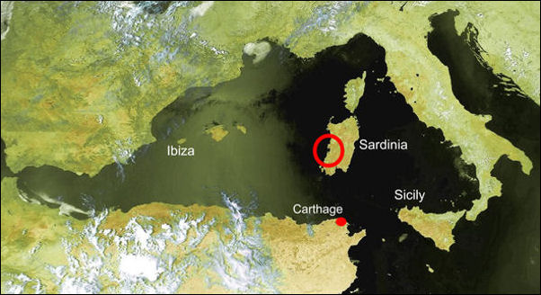
Satellite photograph of the western Mediterranean, with indication of the Terralbese district on the central west coast of Sardinia (see Figure 3 for details).

Excavating a Punic rural settlement
While growing numbers of intensive field surveys are demonstrating clear differences in rural settlement systems, it is also becoming increasingly clear that more detailed archaeological information and, above all, environmental evidence are required to shed light on rural production and agrarian organisation (Reference van Dommelenvan Dommelen & Gómez Bellard 2008). Following earlier fieldwork involving geophysical surveys and intensive surface collections on a number of rural Punic farmsteads in the Terralba district (Reference van Dommelenvan Dommelen & Sharpe 2004; Reference van Dommelenvan Dommelen et al. 2006), we decided to organise a large-scale excavation of one of these sites with the explicit aim to document material culture and environmental remains relating to agrarian production at these sites and in the surrounding Punic countryside of west central Sardinia.
The site at Truncu'e Molas was selected for excavation on the basis of the geophysical surveys that had demonstrated the presence of numerous buried features. A small test trench (2 x 2m) had moreover confirmed the preservation of substantial archaeological deposits up to 80cm below the ploughsoil that could be dated to the late fifth/early fourth century BC and later (Reference van Dommelenvan Dommelen et al. 2006: 163-8).
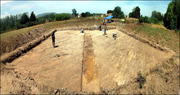
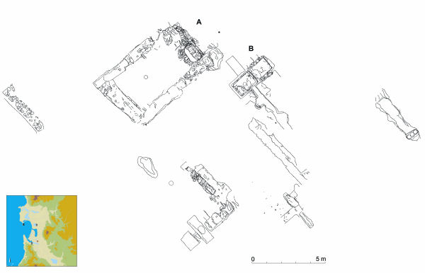
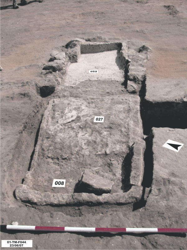
Fieldwork took place in June-July 2007. We began by stripping the topsoil over an area of 20 x 20m, which we subsequently expanded to nearly 20 x 50 m (Figure 2). This revealed a limited number of possible walls and other features that were carefully excavated by hand. The absence of a clear building plan, ploughmarks and a truncated stratigraphy eventually confirmed that recent agricultural activities, in particular the repeated planting and uprooting of vines, had damaged the site to just below the original floor level of the settlement. Although much of the building's ground plan had therefore effectively been destroyed, it was yet also clear that all originally subsurface features had been well preserved in situ. These include two wells, two large basins of what we think was a double wine-press and three amphorae tightly placed upright. In addition, enough stone wall-bases have survived over sufficient length to give a rough idea of the layout of the site (Figure 3). As is confirmed by comparison of the distribution of the excavated walls and other features with that of the previously recorded geophysical anomalies and surface finds, our expanded trench covered the entire area originally occupied by the Punic building. We have accordingly concluded that fieldwork on this site has been completed.
Overview of the initial 20 x 20m trench.


Preliminary results
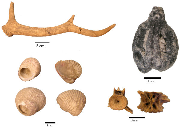
Even if no finds were collected from the ploughsoil, the stratified contexts still yielded large numbers of finds, in particular pottery but also iron tools (sickles, saw blade) and coins. The inventory of these finds lists a total of just over 14 500 items. Dry sieving of most contexts and flotation of samples from relevant deposits resulted moreover in a wide-ranging collection of environmental evidence, comprising many seeds, animal and fish bones, mollusc shells and charred wood fragments. Among the faunal remains, sheep and/or goats appear to constitute the most prominent group, but many other animals, both domesticated (cattle) and wild (deer, birds), are represented as well (Figure 4).
Selection of four types of environmental evidence encountered: a deer antler, a vitis vinifera pip, mollusc shells and fish bones.

Provisional classifications of pottery fragments and the coin evidence, all but one of Punic mint, match to demonstrate that the site was first occupied around the end of the fifth century BC and abandoned in the later second century BC. This coincides exactly with our earlier interpretations of the surface finds (Reference van Dommelenvan Dommelen et al. 2008). Like these previously collected survey finds, the pottery retrieved from the excavated contexts is by and large made up of domestic vessels and amphorae, which confirms the dual function of the settlement for permanent occupation and agrarian production - in other words, as a farmstead.
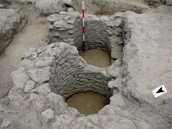
A notable feature is made up by the two wells. Because they partially overlap, it is evident that they were never in use simultaneously, while both the immediate replacement of the first well by a new one and their integration into the building itself suggest the importance attached to them (Figure 5). Both wells are oval in shape (1.20 x 1.40m) and carefully built of small irregular stones, mostly basalt. Both reach a maximum depth of 1.40m below the approximate ancient floor level, which presumably indicates the ancient groundwater level. Although a well is in itself an obvious element in a farmstead, none has so far been attested at a Punic rural site, where cisterns seem to have been the most prevalent means of water supply.
The two wells after excavation (including removal of the later wall visible in Figure 3). It is clearly visible that the one in the foreground partially overlaps the other one.

The most significant find, finally, is the double basin (Figure 6): the careful finishing of hydraulic plaster, the abundant presence of grape-pips (vitis vinifera: Figure 4) and the similarity with better preserved wine-presses at for instance Las Cumbres at the Cerro de San Cristobal near Cádiz (Spain) leave little doubt that this installation was used for pressing grapes. Combined with the presence of two iron pruning sickles, these finds signal the importance of cash-crops like wine in the local rural economy. They also demonstrate that arboriculture was a well-established aspect of the Punic agrarian regime, which flatly contradicts the conventional historical view that Sardinian rural production focused exclusively on cereals (see also discussions in Reference van Dommelenvan Dommelen and Gómez Bellard 2008, chapter 8).
The double basin of what was presumably a double wine-press: they collected the grape juices after pressing on a higher platform that has not been preserved.

Conclusions
While the preliminary results already highlight the significant implications of the finds from Truncu'e Molas, ongoing analysis of the environmental evidence and detailed study of the finds and their contexts will provide a fuller picture of the agrarian practices and domestic lifestyles of the communities inhabiting the Punic rural landscape of western Sardinia. Even so, our excavations have already demonstrated the great potential of careful excavation of small rural sites by bringing to light abundant evidence of agricultural activities (wine press, pruning tools) as well as remains of the crops themselves (grape pips). The large and varied ceramic assemblage recovered is equally informative, as it includes large numbers of amphorae, kitchen wares and imported fine table wares. These finds are all the more significant, because the evidence covers the formative period of the early fourth century BC, when the majority of rural settlements were first established.
Acknowledgements
The excavations at Truncu 'e Molas and subsequent study and publications are a collaborative project between the universities of Glasgow and Valencia with the Soprintendenza Archeologica of Cagliari, co-directed by Peter van Dommelen, Carlos Gómez Bellard and Carlo Tronchetti. We gratefully acknowledge funding awarded by the British Academy, the Spanish Ministerio de Cultura, the Carnegie Trust for the Universities of Scotland and the Universities of Glasgow and Valencia, while the Terralba local council provided important logistical support.