


Impact statement
Climate hazards disproportionately affect pastoral communities because their livelihoods depend directly on climatic and ecological conditions. This study demonstrates that climate adaptation in dryland pastoral systems cannot be effectively addressed through uniform, top-down policies. By applying Participatory Impact Chains (PICs) in ten pastoral communities across the Patagonia drylands of Argentina, the research shows that similar climate hazards—particularly drought—generate markedly different impacts depending on localized social, biophysical, institutional and historical contexts. The findings highlight how vulnerability is socially produced and territorially differentiated, shaped by long-term inequalities, governance structures and environmental trajectories. By foregrounding knowledge co-production with local actors, this work provides actionable insights for designing context-sensitive adaptation strategies that are better aligned with local realities. The study also advances participatory qualitative methodologies for climate risk assessment in arid pastoral regions, offering a transferable framework for addressing climate vulnerability and social inequality in drylands globally.
Introduction
Climate hazards impact pastoral communities due to their dependency on nature for their primary livelihoods. The vulnerability of these communities varies according to their characteristics and context (Adger, Reference Adger2006; Morton, Reference Morton2007). Therefore, understanding the causes of a specific risk requires analyzing the social and environmental attributes of the exposed system, as well as its coping and adaptive capacities (Turner et al., Reference Turner, Kasperson, Matson, McCarthy, Corell, Christensen, Eckley, Kasperson, Luers, Martello, Polsky, Pulsipher and Schiller2003). Lack of knowledge on these particularities limits the capacity to generate appropriately targeted public policies and to design climate risk management strategies for vulnerable pastoral populations.
Climate hazards, both sudden-onset extreme events (such as intense precipitation and floods) and slow-onset physical trends, whether natural or human-induced (such as changes in temperature or precipitation regimes), can affect communities, livelihoods, economic, social and cultural assets, infrastructure, the availability of natural resources, services and ecosystems (CAF, 2014; IPCC, 2014).
The acceleration of global climate change (CC) generates new climate risks, i.e., potential adverse consequences for human and environmental systems. These risks emerge from dynamic interactions between climate hazards, exposure and vulnerability of the affected systems (IPCC, 2022). Understanding such interactions is crucial to properly guide adaptation and mitigation strategies, whose central objective is risk reduction. The increase in climate hazards has been accompanied by greater damage and socioeconomic costs, mainly due to the growing number of people with vulnerable living conditions (Venton and Hansford, Reference Venton and Hansford2006; Olsson et al., Reference Olsson, Opondo, Tschatkert, Agrawal, Eriksen, Ma, Perch, Zakieldeen, Field, Barros, Dokken, Mach and Mastrandrea2014; Borras et al., Reference Borras, Scoones, Baviskar, Edelman, Peluso and Wolford2022).
For this reason, it is essential to understand the factors generating vulnerability as the root causes of risks (Blaikie et al., Reference Blaikie, Cannon, David and Wisner1996). Vulnerability is defined as the conditions determined by physical, social, economic, cultural, institutional, territorial and environmental factors that increase the susceptibility of individuals, communities, assets or systems to the impacts of hazards (Wilches-Chaux, Reference Wilches-Chaux and Maskrey1993; UNDRR, 2017). It is composed of two key factors: (i) sensitivity, understood as the degree to which a system or species can be positively or negatively affected by climate variability or climate change; and (ii) capacity (lack of) to cope and adapt, which refers to the ability of social or environmental systems to adjust, minimize damage, seize opportunities or respond to consequences (Brooks and Adger, Reference Brooks, Adger and Lim2005; IPCC, 2014).
In this sense, Lavell (Reference Lavell2010) points out that risk is a social construct and a population lives in “unsafe conditions” due to historical, social, economic, cultural and political processes that shape differentiated vulnerabilities in different sectors of society. Under these conditions, the scenario that emerges allows us to determine who is exposed to the negative consequences of hazardous processes. Thus, risk does not respond only to natural causes, but also to social processes that continually shape, modify and replicate such risk (Beck, Reference Beck1998; Lampis, Reference Lampis2013; Ribot, Reference Ribot2022).
At the local level, the effects of climate change in rural areas directly impact livelihoods and nature, compromising the economic stability of communities (Borras et al., Reference Borras, Scoones, Baviskar, Edelman, Peluso and Wolford2022; Peña-Garay and Sandoval Díaz, Reference Peña-Garay and Sandoval Díaz2024). Although there are various qualitative and quantitative indices to measure the structural conditions of societies at the national or global levels (Natenzon, Reference Natenzon1995; Cutter et al., Reference Cutter, Boruff and Shirley2003; Mah et al., Reference Mah, Penwarden, Pott, Theou and Andrew2023), they have downplayed the specificities of local populations in relation to their particular vulnerabilities to hazards. In Argentina, despite having a strong tradition of studies on vulnerability and environmental risks, many studies have been focused on urban areas or related to broad geographic scales (Natenzon, Reference Natenzon1995; Occhiuzzi et al., Reference Occhiuzzi, Mercuri and Pascale2011; Herrero et al., Reference Herrero, Natenzon and Miño2018). In addition, Argentina developed a National Plan for Mitigation and Adaptation to Climate Change (MAyDS, 2022), which included the analysis of climate risks and vulnerabilities, although these risks were defined at a regional scale, without considering the biophysical, social and productive heterogeneity of Patagonia.
Patagonia drylands are characterized by harsh environmental conditions, most semi-arid areas, with low annual precipitation, high evaporation and persistent winds that limit ecological productivity (Paruelo et al., Reference Paruelo, Beltrán, Jobbágy, Sala and Golluscio1998). Historically, the processes of valuation and exploitation of nature in Patagonia were central to the appropriation of the territory (Galafassi, Reference Galafassi2010; Godoy et al., Reference Godoy, Fasioli, Valiente and Schweitzer2013). Since the late nineteenth century, dryland areas were destined to the development of a production model based on extensive sheep farming and wool exports (Bandieri, Reference Bandieri2005; Coronato et al., Reference Coronato, Fasioli, Schweitzer and Tourrand2016; Vázquez, Reference Vázquez2019; Coronato and Tourrand, Reference Coronato, Tourrand, Tourrand, Waquil, Maraval, Saïri, Duarte and Kozloski2020). This model has been promoted by the State and involved intensive use of nature, primarily forage, with the resulting pressure and degradation of lands and impact on livestock production (Bendini et al., Reference Bendini, Tsakoumagkos, Pescio, Nogués, Bendini and Tsakoumagkos1993; Andrade, Reference Andrade2005; Pérez Centeno, Reference Pérez Centeno2007; Galafassi, Reference Galafassi2010). This situation has recently worsened as a result of various environmental problems, such as volcanic ash deposition, prolonged droughts, floods and extreme snowfall (Easdale and Rosso, Reference Easdale and Rosso2010; Ejarque, Reference Ejarque2021). Climatic variations are expected to intensify in the coming decades (Camilloni et al., Reference Camilloni, Montroull, Gulizia and Saurral2022).
Participatory climate impact chains (PICs) are a widely recognized tool for analyzing and understanding climate change risks, vulnerabilities and impacts. This resource was developed for the Deutsche Gesellschaft für Internationale Zusammenarbeit (GIZ) as an indicator-based approach to measure and compare vulnerability across different locations, originally for policy-making and the design of national adaptation plans in low-income countries (Zebisch et al., Reference Zebisch, Schneiderbauer, Fritzsche, Bubeck, Kienberger, Kahlenborn, Schwan and Below2021). This relatively simple, practical and useful methodological approach for understanding climate-related processes, however, has not been so widely used (Estoque et al., Reference Estoque, Ooba, Togawa, Yoshioka, Gomi, Nakamura, Tsuji, Hijioka, Watanabe and Kitahashi2022). The general objective of this work is to analyze climate risk in pastoral livestock farming communities in Patagonia drylands using the PICs methodological approach. The specific objectives are as follows: (1) to identify and describe the climate hazard, exposure, intermediate impacts and vulnerability factors in each community; and (2) to compare the results obtained in terms of vulnerability, allowing for the understanding and visualization of local particularities.
Methods
Study area
The study involved various pastoral communities in the Patagonia drylands of Argentina. This area extends over five provinces (Neuquén, Río Negro, Chubut, Santa Cruz and Tierra del Fuego, Antarctica and South Atlantic Islands) between 37°S and 55°S, and covers more than 90% of the regional surface.
It has marked differences in environmental and productive characteristics, determined mainly by a climate influenced by the Andes Mountains, whose altitude and interaction with humid air masses from the Pacific affect precipitation (Paruelo et al., Reference Paruelo, Beltrán, Jobbágy, Sala and Golluscio1998). Predominantly westerly winds generate abundant orographic precipitation as they ascend the Andes (Insel et al., Reference Insel, Poulsen and Ehlers2010), and as they descend, they dry out and generate an arid to semi-arid climate, with annual precipitation below 300 mm, compromising the availability of regional water resources (Garreaud et al., Reference Garreaud, López, Minvielle and Rojas2013).
Regarding climate trends, Patagonia drylands show a significant reduction in annual precipitation and an increase in mean annual temperature (IPCC, 2021). The spatial pattern of trends in annual precipitation shows reductions mostly localized in western Patagonia, particularly north of 45°S. This decline in precipitation over the past century has been attributed to changes in large-scale circulation patterns, such as the expansion of the Hadley Circulation and the southward shift of the storm tracks (Rivera et al., Reference Rivera, Naranjo Tamayo and Viale2020). The spatial pattern of trends in annual temperature shows increases across nearly all of Patagonia, with magnitudes ranging from 0.06 to 0.18 °C per decade for the period 1960–2020 (Camilloni et al., Reference Camilloni, Blázquez, Díaz, Gulizia, Muller, Lovino, Pessacg, Rivera and Saurral2023).
Projected changes in mean annual precipitation show significant reductions in Northern Patagonia, extending towards the steppe region of Chubut and Santa Cruz provinces, and increases in southernmost Tierra del Fuego province and northeastern most Río Negro province. In mean annual temperature, they show widespread increases throughout the twenty-first century (IPCC, 2021). These projections will exert considerable pressure on the agricultural systems and livelihoods that are already subject to climatic constraints.
The agricultural structure consists of estancias (large farms), concentrating the majority of livestock and land, and also of small farms, many belonging to indigenous communities (Mapuche-Tehuelche). The latter are small-scale producers representing 59% of all livestock farmers but owning only 9% of the land (Aranguren et al., Reference Aranguren, Alcoba, Alonso, Alves Rolo, Bruno, Bruno, Celi, Chavez, Figueroa and Fili2025).
After considering the institutional and professional capacities and the regional representation, ten case studies were selected for this study, incorporating communities with small-scale producers, from different provinces, agroecological areas, ethnic compositions and socio-productive organizational structures (Figure 1).
Study area and selected communities. A. Patagonia drylands and wetlands according to the Aridity Index (Verón et al., Reference Verón, Lizana and Maggi2022). B. Projected changes in mean annual precipitation for the period 2081–2100 relative to the baseline period 1961–1990 under the SSP5–8.5 greenhouse gas emissions scenario for Patagonia (IPCC, Reference Lee and and Romero2023).

Methodological design
The PICs-based climate risk and vulnerability framework
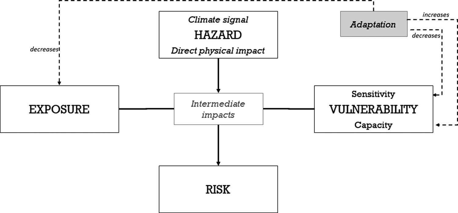
The climate risk and vulnerability assessments in the selected communities made use of the PICs-based risk and vulnerability framework (Menk et al., Reference Menk, Terzi, Zebisch, Rome, Lückerath, Milde and Kienberger2022). The methodological design followed (Figure 2) is based on the guidelines of the IPCC AR5 and AR6 reports, widely accepted by the international community, and on the Vulnerability Sourcebook (Fritzsche et al., Reference Fritzsche, Schneiderbauer, Bubeck, Kienberger, Buth, Zebisch and Kahlenborn2014) and the Risk Supplement to the Vulnerability Sourcebook (GIZ and EURAC, 2017).
Structure and key components of the impact chain. Prepared by the authors based on GIZ and EURAC (2017).

PICs are a visual analytical tool that allows to identify and description of the most relevant factors leading to a specific risk. They provide insight into the causes and effects of climate impacts and contribute to identifying possible adaptation measures (Menk et al., Reference Menk, Terzi, Zebisch, Rome, Lückerath, Milde and Kienberger2022). Their participatory approach involves various stakeholders and the development of conceptual diagrams through a process of knowledge co-production (Zebisch et al., Reference Zebisch, Schneiderbauer, Fritzsche, Bubeck, Kienberger, Kahlenborn, Schwan and Below2021). PICs organize risk factors according to hazard, exposure and vulnerability. They analyze specific hazards and articulate a causal chain that identifies exposure factors as well as biophysical and socioeconomic intermediate impacts, which are modulated by vulnerability factors that increase or decrease the risk (Fritzsche et al., Reference Fritzsche, Schneiderbauer, Bubeck, Kienberger, Buth, Zebisch and Kahlenborn2014; Zebisch et al., Reference Zebisch, Schneiderbauer, Fritzsche, Bubeck, Kienberger, Kahlenborn, Schwan and Below2021; Menk et al., Reference Menk, Terzi, Zebisch, Rome, Lückerath, Milde and Kienberger2022). The development of the PICs in the ten communities involved following a series of steps and answering guiding questions (Table 1).

Field data collection and analysis
The climate risk and vulnerability assessment was approached from a qualitative perspective, as they explore in depth experiences, local perceptions and contextual factors that shape vulnerability to climate change (Ribot, Reference Ribot and Isakson2017). Specifically, a participatory bottom-up approach was used (MITECO, 2023), which allowed for results that reflect voices, perceptions and experiences from technicians, specialists and local stakeholders in each of the case studies. This approach effectively articulated scientific-technical and traditional-local knowledge and incorporated both climatic and non-climatic factors, enriching the understanding of climate risks.
The PICs of the ten communities selected as case studies were carried out between November 2023 and December 2024 in five stages:
-
• Stage 1: Presentation workshop and surveys in each community. The first workshop involved the participation of producers, technicians, government officials and other key stakeholders. Its objective was to present the work proposal and planned activities to obtain community approval. The target area and population were collectively defined. In addition, a survey was administered to an average of 16 livestock producers to assess the socioeconomic and productive conditions as well as the vulnerability to the effects of climate change in each of the ten selected communities. This survey, originally developed by the National Observatory of Land Degradation and Desertification (ONDTyD) (Blanco et al., Reference Blanco, Castro, Corso, Maccagno, Pietragalla and Rubio2016), was adapted to the objectives of the current project (ONDTyD and Fundación InnovaT, 2024).
-
• Stage 2: First workshop for local technical teams. Using a list of regional climate risks compiled in Argentina’s National Plan for Adaptation and Mitigation to Climate Change (MAyDS, 2022) and regional literature reviewed, key risks for each community were selected and prioritized (Table 2). Preliminary impact chains were developed for the prioritized risks, with the aid of a series of steps and guiding questions (Table 1).
-
• Stage 3: Preliminary impact chains fine-tuning. Each local technical team made a new version of the impact chains. The task involved a deeper understanding of climate impacts and risks, as well as of the risk components identified in the preliminary chain, considering survey results, available literature and the expert knowledge of the local technical team.
-
• Stage 4: Validation workshop in the communities. This workshop also included the participation of producers, technicians, government officials and other key stakeholders. The objective was to validate the preliminary chains developed by the local technical teams in the previous stage. Participants modified and validated the resulting PICs.
-
• Stage 5: Second workshop for local technical teams. This workshop aimed to obtain the final evaluation of the ten PICs.
Risk components, dimensions and variables

Note: Prepared by the authors based on regional literature and background.
Results
Climate-related risks
Fieldwork was conducted considering the selected dimensions and resulted in the impact chains. The assessments in the ten communities reveal a marked exposure to climate hazards exacerbated by climate change. Table 3 shows that the main climate hazard identified is drought. In most cases, low precipitation is mentioned as a climate signal. The northern communities of the region also highlighted high temperatures, strong winds and extraordinary rainfall, while for the southern communities, heavy snowfall was noted.
Climate-related risks, hazards and intermediate impacts in the communities

Note: Prepared by the authors based on validated PIC in each community.
According to the communities, these hazards represent significant negative intermediate impacts on ecosystems, primarily grasslands, mallines (wetland meadows) and water sources, which leads to a decrease in forage availability for livestock. Some communities also detail direct impacts on animal mortality and, consequently, on livestock numbers, while only one community (Sierras de Telsen) mentions a social impact on both on- and off-farm infrastructure.
Climate-related vulnerabilities
Based on prioritized risks and identified intermediate impacts, Table 4 shows that all communities agreed on pastoral households as being the most affected element. However, some communities also reported biophysical components, such as grasslands and water sources, while others emphasized on-farm infrastructure or animal production.
Exposure and vulnerability in the communities

Source: Prepared by the authors based on validated PICs in each community.
As seen, various vulnerability factors are observed. On the one hand, sensitivities were identified at different levels and constitute a negative attribute for developing an adaptive strategy to climate change:
-
(i) Biophysical sensitivity: it is characterized by degraded and eroded soils with low water storage capacity and high surface runoff. In addition, the region shows degraded grasslands and mallines (wetland meadows), with low productivity and limited water availability.
-
(ii) Production system sensitivity: although livestock farming was recorded as a relevant activity, in many cases, the surface area and number of animals do not guarantee the reproduction of the familiar unit. A lack or deterioration of productive infrastructure is generally noted.
-
(iii) Social sensitivity: the vast majority of families identify themselves as small subsistence farmers, have few members and, in many cases, include an aging population (mainly male), which can hinder the adoption of highly labor-intensive technologies or practices.
-
(iv) Habitat sensitivity: having two or multiple residences was consistently identified as a common strategy to address the needs of families to access the education, services or job opportunities found in urban centers, far from the farmlands. This can lead to family separation and, in some cases, to the young members abandoning farm-based primary production, which often results in permanent migrations. The precarious living conditions in some areas – including their isolation, difficulties to access properties, limited means of communication, and a lack of housing and basic services– is also a general characteristic of the farmlands.
-
(v) Political/institutional sensitivity: different factors are evident in each community, including limited community organization, a lack of marketing organization, discontinuity in rural development policies, and limited articulation between scientific-technical and traditional-local knowledge.
On the other hand, some noteworthy capacities that can contribute to climate change adaptation or mitigation practices are detailed as follows:
-
(i) Knowledge capacities: the knowledge and experience acquired in project management, traditional-local knowledge linked to the environment (for example, transhumance in the communities of Neuquén province or the use of native medicinal plants in communities with a strong presence of indigenous communities), available local scientific research on the environment, and access to training and technical assistance.
-
(ii) Tech adoption capacities: energy-efficient rural housing, availability of productive infrastructure (waterworks, pens and shelters and electric fences), and actions linked to natural resources and livestock management (on-farm assessment and planning, pasture seeding, cattle grazing in mallines, transhumance, strategic supplementation, livestock protection dogs, birthing management, feedlot fattening, adaptive grazing management, fodder bank, among others).
-
(iii) Economic and financial capacities: production systems that guarantee food self-sufficiency; joint commercialization of products in some organized communities; installed capacity to manage and administer projects (on-farm improvements, joint purchases, etc.) and revolving funds. In certain cases, in response to production difficulties, the diversification of economic activities (market garden, poultry farming, plant nursery, etc.) is encouraged for increasing or sustaining income, in order to achieve familiar unit reproduction and even maintain the agricultural activity. Multiple activities and/or sources of income allow families to sustain primary livestock production (affected by low yields, low profitability levels and other production impacts caused by extreme weather events).
-
(iv) Political/institutional capacities: presence of institutions and organizations that contribute to capacity building and promote new productive strategies.
Discussion
The application of PICs as a methodological tool allowed for a visual and systemic representation of the factors that shape climate risk in pastoral communities of Patagonia drylands. This work fills a knowledge gap regarding both climate risk analysis in Latin America and environmental issues in particular, considering that, so far, there has been a predominance of European and infrastructure studies (Menk et al., Reference Menk, Terzi, Zebisch, Rome, Lückerath, Milde and Kienberger2022) or studies focused on quantitative data that fail to explore the topic in depth (Zebisch et al., Reference Zebisch, Schneiderbauer, Fritzsche, Bubeck, Kienberger, Kahlenborn, Schwan and Below2021).
Furthermore, the methodology used in this work evidences the importance of the efforts made to co-produce knowledge related to climate risks. Although such efforts evolve toward more interactive approaches – where researchers, practitioners, and decision-makers work together to generate results rather than simply transferring knowledge from research to practice (Runhaar et al., Reference Runhaar, Wilk, Persson, Uittenbroek and Wamsler2018; Norström et al., Reference Norström, Cvitanovic, Löf, West, Wyborn, Balvanera, Bednarek, Bennett, Biggs, De Bremond, Campbell, Canadell, Carpenter, Folke, Fulton, Gaffney, Gelcich, Jouffray, Leach, Le Tissier, Martín-López, Louder, Loutre, Meadow, Nagendra, Payne, Peterson, Reyers, Scholes, Speranza, Spierenburg, Stafford-Smith, Tengö, Van Der Hel, Putten and Österblom2020), it is necessary to incorporate the affected local communities and their own know-how to improve the perceived relevance and legitimacy of the results, and to foster mutual learning and ownership of the problems (Hansson and Polk, Reference Hansson and Polk2018; Bremer et al., Reference Bremer, Wardekker, Dessai, Sobolowski, Slaattelid and Van Der Sluijs2019). Likewise, integrating these voices with those of the field technicians, who are recognized and work continuously with the producers, knowing their situations firsthand, can help to mitigate the biases of individual interpretations.
Regarding results, one noteworthy aspect is that, although exposure to drought is widespread, its impacts are not: they are amplified or mitigated according to local sensitivities and capacities. Likewise, the way risks, their intermediate impacts, and vulnerability (both sensitivities and capacities) are understood is the result of a social construct (Andrade, Reference Andrade2005; Ejarque, Reference Ejarque2021) that differs between communities and internally among producers and other stakeholders, despite belonging to the same region with similar bioclimatic characteristics.
Therefore, PICs highlight the heterogeneity of sensitivities and capabilities among communities not only related to environmental and productive dimensions, but also to socioeconomic, sociopolitical and habitat aspects. While some communities exhibit highly precarious living conditions and limited organizational capacity, others display institutional strengths and adaptive technological capabilities that could be scaled or replicated in similar contexts. In some communities in northern and central Patagonia, habitat and economic sensitivities are more extreme, while in southern Patagonia, it is environmental and productive issues that threaten producer activities. This heterogeneity also appeared in previous studies, though those highlighted the influence of the State and the markets in generating different sensitivities (Wang et al., Reference Wang, Brown and Agrawal2013). Some of the capabilities are also related to traditional knowledge passed down by indigenous communities over generations (Kronik and Verner, Reference Kronik, Verner, Mearns and Norton2010).
It is worth mentioning that the diversity in the results of these PICs can be explained through different causes – sociohistorical, productive, economic or cultural –, given that environmental problems arise from pre-existing structures, and that those causes produce diverse impacts (Ribot, Reference Ribot2011; Kashwan and Ribot, Reference Kashwan and Ribot2021; Paprocki and McCarthy, Reference Paprocki and McCarthy2024). Therefore, these processes are experienced differently in different communities, places and scales (Borras et al., Reference Borras, Scoones, Baviskar, Edelman, Peluso and Wolford2022). These findings coincide with those presented by recent studies in the region (Ejarque, Reference Ejarque2021; Enriquez et al., Reference Enriquez, Fernández, Aramayo, De Pascuale, Ocariz and Tittonell2023; Laborda et al., Reference Laborda, Easdale, Fallot, Ocariz and Tittonell2023; Fantozzi, Reference Fantozzi2024; Hurtado et al., Reference Hurtado, Michel, Fernández, Calianno and Easdale2024), which highlight the need to understand Patagonian pastoral systems from a local perspective that recognizes the specificity of the territories and the historical trajectories of their communities.
The heterogeneity in the results may also be related to biases arising from the context where the PICs were developed, as well as the emphasis placed by the participating stakeholders and work team. This bias in the production of climate knowledge is present in this methodology and has been observed in various previous studies. Therefore, it is recommended that the PICs development group be composed of people with different perspectives and that efforts be made to compensate when there is limited information or experience (Zebisch et al., Reference Zebisch, Schneiderbauer, Fritzsche, Bubeck, Kienberger, Kahlenborn, Schwan and Below2021; Menk et al., Reference Menk, Terzi, Zebisch, Rome, Lückerath, Milde and Kienberger2022).
In this sense, factors related to biophysical, productive, political and institutional sensitivity, and those identified as capabilities, are key inputs for identifying mitigation and adaptation measures. The participatory approach adopted, with its successive validations in community workshops, favored the appropriation of the assessment and amplified the collective understanding of risk factors, providing social legitimacy to the results. It also allowed for the effective integration of diverse knowledge, both technical-scientific and local-traditional. This point is central to the design of differentiated policies and strategies, with approaches that combine territorial, social and ecological criteria (Wang et al., Reference Wang, Brown and Agrawal2013; Borras et al., Reference Borras, Scoones, Baviskar, Edelman, Peluso and Wolford2022) as well as short-term and long-term factors (Ribot, Reference Ribot2022; Paprocki et al., Reference Paprocki, Camargo, Taylor, Bhasme and Mills-Novoa2025).
Conclusions
This study analyzes climate risk in pastoral livestock communities of Patagonia drylands and identifies different relevant hazard, exposure and vulnerability factors among the livestock farming communities.
The vulnerability analysis shows that the social, political and economic conditions limit their possibilities to access the necessary resources for implementing measures that reduce sensitivity and increase coping and adaptive capacity against climate risks. Also, despite some common points at the regional level, the results reveal internal heterogeneities that must be taken into account when adaptation and mitigation strategies are proposed. Climate vulnerability and risk assessments should not be standardized; instead, they require context-sensitive approaches and iterative assessment mechanisms that allow for monitoring over time, and should be complemented with both quantitative and qualitative information (i.e., mixed-methods approaches) to enrich the analysis and better capture the complexity of vulnerability processes.
A final recommendation is that these analyses need to be accompanied by access to financing and technical support to guarantee the adequate implementation of measures and the appropriation of the technological changes.
Open peer review
For open peer review materials, please visit http://doi.org/10.1017/dry.2026.10021.
Data availability statement
The data supporting the findings of this study are available at: https://www.pastizalespatagonicos.com/paginas/informes.html
Acknowledgements
Our thanks to the local farmers and social stakeholders from the ten communities, and the technicians and professionals who took part of the fieldwork and belong to the following institutions: Zapala, Ingeniero Jacobacci, Paso de Indios and El Maiten INTA Extension Agencies, INTA IPAF Patagonia, INTA EEA Esquel and Chubut (Trelew), CONICET, National University of Patagonia Austral, University of Buenos Aires, and National University of Tierra del Fuego, Antártida e Islas del Atlántico Sur. We express our gratitude also to the National Observatory on Land Degradation and Desertification, based at IADIZA-CONICET Mendoza, for its support. We also thank two anonymous reviewers for their suggestions and Claudia Bottero for her work with translation.
Author contribution
Conceptualization: A.F., S.A.R., M.E., A.T.; Data Collection: S.M., C.M., R.N., C.M.R.; Data Curation: A.F., S.A.R., M.E., S.M., C.M., R.N., C.M.R., A.T.; Fieldwork: A.F., S.A.R., M.E., S.M., C.M., R.N., C.M.R., A.T.; Investigation: A.F., S.A.R., M.E., A.T.; Methodology: A.F., S.A.R., M.E., A.T.; Software: S.A.R., M.E.; Visualization: A.F., S.A.R., A.T.; Writing – Original Draft: A.F., S.A.R., M.E.; Writing – Review & Editing: A.F., S.A.R., M.E.
Financial support
This study was funded by the Green Climate Fund, as part of a Readiness grant titled “Innovation for climate resilience of Patagonian grasslands of Argentina: minimizing climate vulnerability of rural inhabitants, increasing capacities for range and soil regeneration, and conserving biodiversity”; and implemented by Development Bank of Latin America and the Caribbean (CAF) and Fundación InnovaT.
Competing interests
The authors declare none.


 Open access
Comments
San Carlos de Bariloche, Argentina
4th December 2025
Cambridge Prism: Drylands
We are pleased to submit the article entitled “Using participatory impact chains for assessing regional climate risks and local particularities: a case study in Patagonia drylands” to be considered for publication in the Cambridge Prism: Drylands. We appreciate the invitation from the editors to submit this article in the upcoming Thematic Collection entitled “Arid Lands of South America: Ecology without borders that integrates environment and society”.
For this reason, as authors we certify that we have directly contributed to the intellectual content of the paper, we are responsible and approve it, and we agree that our names appear as authors. We also declare that the article is not under consideration by another scientific journal for publication and there is no overlap with previously published information. Finally, we state that there was no conflict of interest during the conduct of the study and that we have complied with the ethical recommendations and regulations for social science studies in our country.
Yours faithfully,
Fantozzi, Anabella
Instituto de Investigaciones Forestales y Agropecuarias de Bariloche (IFAB), INTA-CONICET
San Carlos de Bariloche, Río Negro, AR
Romano, Silvina Alejandra*
Instituto de Desarrollo Económico e Innovación, UNTDF
CONICET-UNTDF
Ushuaia, Tierra del Fuego, Antártida e Islas del Atlántico Sur, AR
Ejarque, Mercedes
Instituto de Investigación y Desarrollo Tecnológico para la Agricultura Familiar Región Patagonia, INTA
Plottier, Neuquén, AR
Meza, Santiago
Agencia de Extensión Rural Paso de Indios, INTA
Paso de Indios, Chubut, AR
Moscardi, Carla
Instituto de Ciencias del Ambiente, Sustentabilidadad y Recursos Naturales, Unidad Académica San Julián, UNPA
Puerto San Julián, Santa Cruz, AR
Navedo, Rodrigo
Agencia de Extensión Rural Zapala, INTA
Zapala, Neuquén, AR
Rostagno, Cesar Mario
CONICET
Puerto Madryn, Chubut, AR
Therburg, Almut
Instituto Argentino de Investigaciones de las Zonas Áridas, CONICET
Mendoza, Mendoza, AR
*Corresponding author
Instituto de Desarrollo Económico e Innovación, Universidad Nacional de Tierra del Fuego Antártida e Islas del Atlántico Sur (UNTDF)
Ushuaia, Tierra del Fuego, Antártida e Islas del Atlántico Sur, AR
sromano@untdf.edu.ar