
Location of Terramara Santa Rosa.

The term terramare indicates banked and moated villages of the Middle and Late Bronze Ages (1600–1150 BC), located in the alluvial plain of the river Po, mostly in present-day Emilia Romagna. Since the beginning of research on the terramare in the nineteenth century (Pearce 1998), it has been clear that the moat surrounding these sites was connected to adjoining rivers from which water was obtained by canals. Recent research and the excavation at the Terramara Santa Rosa near Poviglio (Reggio Emilia) (Figure 1) have confirmed the consistency of this model and demonstrated that sites may have acted as key locations in a hydrological network; their moats, aside from defensive purposes, were mostly intended to collect and channel water and redistribute it to irrigate the surrounding fields.
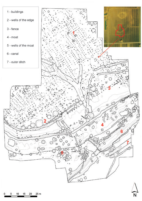
The excavations at the Terramara Santa Rosa have revealed, since 1994, a settlement composed of rectangular buildings, delimited at the margin of the village by regularly spaced postholes corresponding to a peripheral fence (Figures 2 & 3). A steep scarp at the edge of the village drops down to the bottom of the moat, becoming its inner bank. The moat itself is wide, shallow, asymmetrically concave and runs parallel to the village fence — smooth and gradual on the exterior, steep and inaccessible on the village side.
The Terramara Santa Rosa shown in an aerial photograph including the area under excavation since 1994. The main archaeological structures are indicated. 1) buildings; 2) wells of the edge; 3) fence; 4) moat; 5) wells of the moat; 6) canal; 7) outer ditch.

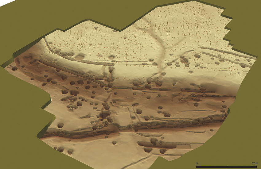
The Terramara Santa Rosa: terrain model of the excavated features.

Further out, a large canal (Figure 4) meets the moat at a shallow angle. It is wide and deep; its banks are regularly terraced to provide stability, and it is separated in two by a sort of dam which serves to regulate the water discharge. This canal was meant to connect the moat to an adjoining palaeochannel, providing the archaeological proof for a model proposed by nineteenth-century scientists. Yet, present-day evidence is more complex than this, as one more ditch, originating from three water wells, has been discovered outside the canal, slightly diverging from it.
The canal, divided in two parts by a shallow dam; notice the stepped banks.

All these hydrological structures date back to the late Middle Bronze Age and are the output of a unitary planning project, as one road, leading from the interior of the village, crosses both the moat and the canal and is aligned with the point of origin of the outer ditch (Figure 5a). A number of large water wells were opened along the edge of the village after the Middle Bronze age. Re-excavated several times, they were kept in use for more than a century. Exploiting sandy aquifers at the depth of 2m and 3m respectively, they acted as artesian wells, and the water extracted was conveyed, through interconnecting ditches, not to the interior of the village, but to the part of the moat which, lying in an upstream position, was not directly supplied by the confluent canal.
During the Late Bronze Age, the whole hydraulic system underwent a noteworthy change (Figure 5b). The wells along the fence went out of use and the canal and adjoining ditch were abandoned and silted up, never to be reactivated. The moat was consequently deprived of water, which was searched for and provided by numerous wells excavated in its base. Most of these are clustered at the outer margin of the moat, surrounded by reservoirs connected by small ditches, so as to make use of the water available in the countryside. The latter appears to be the true beneficiary of the planning and implementation of the hydraulic system.
The wells in the moat reached a water table lying 5m under the present surface, i.e. 2m deeper than the aquifers exploited during the earlier periods. This indicates an important drop in the water table, attesting to a drought in the last phase of the village. This may have played a role in the abandonment of the village and in the contemporaneous collapse of the terramare system (Cremaschi et al. 2006; Reference CardarelliCardarelli 2010).
Comparison of the hydraulic structures in use during the Middle-Late Bronze Age (a) and during the Late Bronze Age (b); the road is indicated in yellow.

A carinated cup deposed as an offering inside a well of the moat.

Several wells at the margin of the moat, dating back to the last phase of its use, were found to include isolated, almost complete, vessels. These consist mostly of carinated cups and more rarely of bowls (Figure 6). Each vessel appears to have been carefully deposited, its mouth turned upwards, at the base or at the margin of features deprived of any other archaeological find. Most probably these vessels represent offerings deposited in the context of a water cult, which the local find of a ritual pool at Noceto (Bernabò Brea & Cremaschi 2009) has recently proved. For the Bronze Age, this is represented over the whole of Europe by the deposition of objects in lakes, swamps and water courses. Further studies are necessary to understand if there is a causal connection between the appearance of such offerings at Santa Rosa and the incoming drought at the end of the terramare period.