


INTRODUCTION
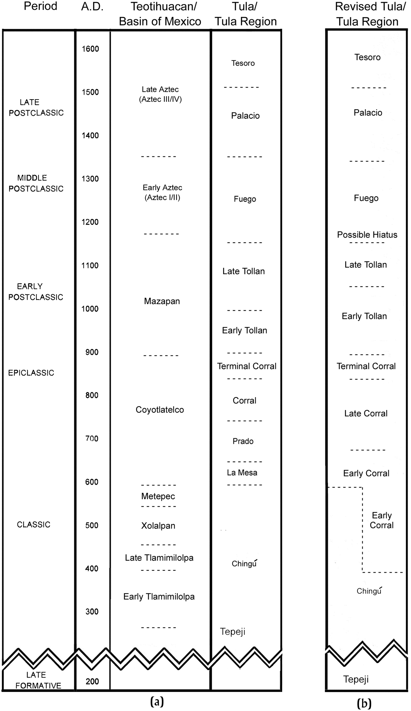
One of the benefits of the many archaeological investigations conducted at Tula and in the surrounding region in the 70 years following Acosta's pioneering investigations has been the periodization of Tula's settlement history and the development of a corresponding chronological framework, not to mention the considerable light shed upon life in the ancient city. Initially conceived by Acosta (Reference Acosta1945, Reference Acosta1956–1957) as a two-period scheme with limited ceramic typological definition, the current chronology for Tula was created by Cobean (Reference Cobean1978, Reference Cobean1990), using ceramics recovered from survey and excavation by the University of Missouri and the Instituto Nacional de Antropología e Historia (INAH; Cobean Reference Cobean, de Escobar, Cobean and Healan1982; Healan Reference Healan1989; Matos Reference Matos Moctezuma1974b, Reference Matos Moctezuma1976). Since its formulation, Cobean's original seven-phase sequence has been revised numerous times in light of new information from regional survey and excavation at Tula and other sites, producing the chronology seen in Figure 1a and published by Mastache et al. (Reference Mastache, Cobean and Healan2002), and the ceramic complexes seen in Table 1, as published by Cobean (Reference Cobean1990). The present article synthesizes data from previous research, including recent research described in other articles in this Special Section, that have had a major impact upon previous conceptions of Tula's origins, development, and subsequent decline, one result of which is the revised chronological scheme described below and presented in Figure 1b.
(a) Chronology for Tula as established by Mastache et al. (Reference Mastache, Cobean and Healan2002), and portions of the chronology for Teotihuacan (Sugiyama Reference Sugiyama, Nichols and Pool2012:Figure 15.4) and the Basin of Mexico (Sanders et al. Reference Sanders, Parsons and Santley1979:Table 5.1). (b) Revised chronology for Tula as presented in this article. Horizontal dashed lines indicate approximate temporal boundaries between phases. Chart prepared by Healan.
Ceramic complexes, corresponding phases, and principal types in the Tula ceramic chronology (Cobean Reference Cobean1990).

Until very recently, there were few chronometric dates for Tula, in the absence of which its chronology was largely based upon ceramic cross-dating. With the additional radiocarbon dating presented in several of the other articles in this Special Section, plus a number of dates presented for the first time in this article, there are now some 68 published radiocarbon dates for Tula (Table 2; Figures 4–9), plus 11 archaeomagnetic dates, which collectively span a period of more than 1,000 years (Figure 9).
Radiocarbon dates obtained for Tula, arranged by locality and median probability date (Telford et al. Reference Telford, Heegaard and Birks2004). Chart prepared by Healan.

The 68 radiocarbon dates featured in this article were performed by four different laboratories over a period of more than 50 years (Table 2). All dates have been calibrated using the CALIB Radiocarbon Calibration Program, version 7.0.4 (Stuiver and Reimer Reference Stuiver and Reimer1993). Basic information for each date is presented in Table 2, and their one-sigma and two-sigma ranges are shown graphically in Figures 4–6 and 8–9. Although it is now common practice to graphically depict the range of a radiocarbon age determination using its full probability distribution, with the exception of Figure 7 we have used the older convention of presenting the one- and two-sigma probability ranges as a shaded bar, a simpler representation that in our experience facilitates pattern recognition more effectively when comparing large numbers of dates. For Figure 7, full probability distributions are presented for six dates whose ranges span two phases (Early Tollan and Late Tollan), in order to demonstrate that all are most likely Early Tollan phase dates.
It is often convenient to provide a point estimate for a radiocarbon date, which in the present study provided an objective method for ordering their graphical representations in time. In the past, two commonly used point estimates have been uncalibrated mean date (years B.P. or its inverse) and intercept (intersection of mean date and calibration curve), although the former does not consider the adjustments provided by calibration, and the latter is overly sensitive to these adjustments, as determined by Telford et al. (Reference Telford, Heegaard and Birks2004). These authors recommend using either weighted mean probability or median probability, both of which they found were relatively robust and stable estimates. We have used median probability, a statistic provided by the CALIB Radiocarbon Calibration Program.
Tula is located in central Mexico, slightly north of the Basin of Mexico, in the southwest corner of a broad alluvial plain formed by the Tula River and several other streams (Figure 2). The site core occupies an elongated north–south upland along the Tula River, containing three large mound/plaza complexes, designated Tula Grande, Tula Chico, and the Plaza Charnay (Figure 3). Tula Grande, the southernmost complex, constituted Tula's political and religious center during its apogee (Figure 3, inset). The northernmost, Tula Chico, is a smaller complex that appears to have been the political and religious center for Tula's earliest settlement. The two are so named because of their similarities in layout, which suggest that Tula Grande was modeled on its earlier, smaller counterpart (Matos Reference Matos Moctezuma and Moctezuma1974a).
The Tula region and its location in central Mexico (inset), showing the location of (a) Chingú, (b) La Mesa, and (c) other Coyotlatelco hilltop sites. Map by Cobean; inset map modified from Raisz (Reference Raisz1959).

Planimetric map of Tula, showing the limits of the prehispanic city (dashed line), as determined by Mastache and Crespo, and the Tula Grande monumental precinct (inset). Numbers refer to localities where Tollan phase residential structures have been extensively exposed by excavation. Locality names and bibliographic references are listed in Table 3. Map by Healan, adapted from Yadeun Reference Yadeun and Matos Moctezuma1974. Plan (inset) adapted from Mastache et al. Reference Mastache, Cobean and Healan2002.

Localities specified in Figure 3.

LATE FORMATIVE (TEPEJI PHASE) AND CLASSIC PERIOD (CHINGÚ PHASE) SETTLEMENT IN THE TULA REGION
Although there is evidence of a Middle Formative occupation of unknown size within the limits of Tula itself (Mastache and Crespo Reference Mastache and Crespo1982:13–17), the first documented settlement in the region occurred during the Late Formative Tepeji phase, knowledge of which is limited to two hamlet-size sites in the Tula River alluvial valley, plus La Loma, a large (15 ha) hilltop site overlooking the Tula River, 10 km south of Tula (Mastache et al. Reference Mastache, Cobean and Healan2002:44). Tepeji phase ceramics (Table 2) include Ticoman III pottery from the Basin of Mexico and Chupícuaro pottery and figurines, a ceramic tradition native to central Guanajuato that also occurs in small quantities at numerous sites in the Basin of Mexico (Darras Reference Darras2006), although Chupícuaro ceramics are more common at La Loma, comprising as much as 5 percent of decorated ceramics at the site (Healan Reference Healan2019).
The Classic period Chingú phase marks the first substantial settlement of the region, with the appearance of over 200 sites in the alluvial plain and adjacent calcareous hills, whose ceramic assemblage consisted principally of diagnostic Teotihuacan ceramics (Healan and Cobean Reference Healan, Cobean and Beekman2019:69–72; Mastache et al. Reference Mastache, Cobean and Healan2002:51–55). Most appear to be small sites, perhaps hamlets or campsites, but include 13 large, nucleated sites with monumental architecture, the largest of which, Chingú (Figure 2a), covered an area of over 2.5 km2 and exhibited a layout and architectural features like those of Teotihuacan (Díaz Reference Díaz1980; Mastache et al. Reference Mastache, Cobean and Healan2002:51–55). There seems little doubt that Chingú and the settlement system it apparently managed were under the control of Teotihuacan; indeed, the substantial increase in settlement from the preceding period suggests outright colonization by Teotihuacanos or those with close ties to Teotihuacan. No chronometric dates were obtained, but Chingú phase ceramics include diagnostic types of the Tzacualli, Tlamimlolpa, Xolalpan, and Metepec phases at Teotihuacan, with the largest number of settlements appearing to date to the Early/Late Tlamimilolpa phase. No attempt was made to subdivide the Chingú phase based on the corresponding ceramic sequence established by Rattray (Reference Rattray2001) for Teotihuacan.
A major activity of the Chingú phase occupation was almost certainly exploitation of the abundant lime sources in the area, given the concentration of sites in the calcareous hills and evidence that a significant proportion of the stucco at Teotihuacan probably came from these deposits (Barba et al. Reference Barba, Blancas, Manzanilla, Ortiz, Barca, Crisci and Miriello2009). The agriculturally productive alluvial plain was probably an exploited resource as well, as a number of Chingú phase sites are situated along two present-day irrigation canals that date at least to the colonial period (Mastache and Crespo Reference Mastache, Crespo and Moctezuma1974; Mastache et al. Reference Mastache, Cobean and Healan2002:35, 59). Indeed, Chingú itself is situated at the terminus of one of these canals (Mastache et al. Reference Mastache, Cobean and Healan2002:Figure 4.2).
Despite the abundant Chingú phase settlement in the surrounding area, relatively few Teotihuacan ceramics were recovered in survey within Tula itself, suggesting that “there probably were no relevant Classic period occupations” at the site (Mastache et al. Reference Mastache, Cobean and Healan2002:55). One of the larger Chingú phase sites lay less than 2 km to the north; nevertheless, it is surprising that there would be no Chingú phase settlement where Tula is situated, considering its advantageous location at the confluence of two rivers. In fact, this interpretation has been considerably modified in light of new evidence presented by Cobean et al. (Reference Cobean, M. Healan and Suárez2021) and summarized below.
COYOTLATELCO-RELATED SETTLEMENT AT TULA AND IN THE TULA REGION
The earliest identifiable settlement at Tula itself is associated with Coyotlatelco, a distinctive ceramic complex that is generally believed to have appeared in central Mexico sometime around the demise of Teotihuacan and the beginning of the Epiclassic period, currently estimated to have occurred atround a.d. 600/650. First identified in the Basin of Mexico, Coyotlatelco ceramics typically exhibit red-painted geometric and other designs applied to the interior and/or exteriors of natural or cream-slipped hemispherical and flat-bottomed bowls and other vessels (Rattray Reference Rattray1966). In his initial explorations, Acosta (Reference Acosta1945:65) identified Coyotlatelco pottery in the lower levels of at least one of several test pits excavated on the western periphery of Tula Grande. The most substantial evidence of Coyotlatelco occupation at Tula comes from Tula Chico, as determined by exploratory excavations conducted by Moedano (Acosta Reference Acosta1945), Matos (Reference Matos Moctezuma and Moctezuma1974a), and Cobean (Reference Cobean1978, Reference Cobean, de Escobar, Cobean and Healan1982), and more recent extensive excavations described by Cobean et al. (Reference Cobean, M. Healan and Suárez2021).
The abundant Coyotlatelco ceramics recovered from Cobean's exploratory excavations at Tula Chico played a major role in his formulation of the Tula ceramic chronology (Cobean Reference Cobean1990). In addition to Coyotlatelco ceramics, which he designated the Corral complex at Tula (Table 1), Cobean identified a distinctive sub-assemblage in the lowest levels of his excavations, designated the Prado complex (Table 1), which he later determined was also present in the lowest levels of the exploratory pits excavated by Matos. Principal Prado complex types include well-made painted and incised red on brown and black polished serving vessels (Table 2). Based on these data, Cobean (Reference Cobean1978, Reference Cobean1990) divided the Coyotlatelco-related occupation at Tula into two phases, designated the Prado and Corral phases (Figure 1a). It must be noted, however, that the two ceramic complexes are by no means mutually exclusive, given that Prado phase contexts invariably contain both Prado complex and Corral complex ceramics. Mastache and Cobean (Reference Mastache, Cobean, Diehl and Berlo1989:42) characterize the Prado phase as Tula's earliest occupation, which “stratigraphically precedes the ‘full-blown’ Coyotlatelco manifestation” in the subsequent Corral phase.
Systematic regional survey (Mastache Reference Mastache1996; Mastache et al. Reference Mastache, Cobean and Healan2002) revealed that Tula Chico was only one of many Coyotlatelco sites in the Tula region. Mastache's survey encountered around 180 sites with Coyotlatelco ceramics, mostly small sites located in the alluvial plain, but also ten large, nucleated settlements, situated on hilltops or elevated terrain on the periphery of the plain (Figures 2b and 2c) that were believed to be the earliest Coyotlatelco settlements in the region. One of the largest hilltop sites, La Mesa (Figure 2c), was mapped and excavated, covering an area of about 1 km2 and containing two monumental complexes surrounded by probable residential terraces (Mastache and Cobean Reference Mastache, Cobean, Diehl and Berlo1989). The other hilltop sites exhibited monumental architecture and terracing as well, which led these authors to suggest that each was the center of a distinct polity, reminiscent of Tezoyuca phase hilltop settlements at the south end of the Teotihuacan valley during the Terminal Formative period (Sanders et al. Reference Sanders, Parsons and Santley1979:104–105). Citing the previous work of Parsons and Darling (Reference Parsons and Darling2000), Anderson et al. (Reference Anderson, Healan, Cobean and Faulseit2016:448) suggested that a large component of the obviously successful adaptation of these settlements to marginal hilltop terrain was cactus-based cultivation, including maguey, an important source of food and beverage for this region during the Aztec period and even today.
The peripheral location of the Coyotlatelco hilltop sites with respect to Chingú phase sites in the alluvial plain and calcareous hills forms a complementary distribution that Mastache and Cobean suggested was an indication that the two settlement systems overlapped in time. This possibility is examined in light of new data in the next section.
Mastache and Cobean (Reference Mastache, Cobean, Diehl and Berlo1989:56) believed that La Mesa and the other hilltop sites were earlier in time than Tula Chico. This was based upon Coyotlatelco ceramics at La Mesa and the other hilltop sites, whose painted motifs were perceived as simpler in form and execution, hence developmentally and temporally earlier than Corral complex ceramics in the Prado and Corral phases at Tula Chico. Thus these authors assigned La Mesa and the other hilltop sites to their own (La Mesa) phase, which preceded both the Prado and Corral phases in time (Figure 1a).
To summarize, the Coyotlatelco occupation at Tula and in the Tula region was divided into three successive (La Mesa, Prado, Corral) phases (Figure 1a), the earliest of which, La Mesa, may have overlapped in time with the Chingú phase. Tula Chico was supposedly not settled until the Prado phase, tentatively dated to around a.d. 650, and appears to have later supplanted the other hilltop settlements to become the sole political center in the region during the Corral phase, estimated to have begun around a.d. 750 (Figure 1a). According to this chronology, Tula's initial settlement and the Chingú phase settlement system would not have overlapped in time.
NEW PERSPECTIVES ON COYOTLATELCO SETTLEMENT AT TULA AND IN THE LARGER REGION
One problem with the periodization summarized in the preceding paragraph is that three phases are crammed into the roughly 250-year Epiclassic period, providing rather little time for the events associated with each phase to transpire. In light of new data presented below and in other articles in this Special Section, the chronology of Coyotlatelco settlement at Tula and the larger region and its relationship to the Chingú phase settlement have been significantly revised, along the following lines.
Replacement of the Prado Phase/Corral Phase Nomenclature
A key aspect of this revision has been major changes to the tripartite La Mesa, Prado, Corral phase scheme, beginning with the Prado and Corral phases. While Prado complex ceramics occupy the lowest levels of local stratigraphic sequences, Corral complex ceramics are invariably also present and almost always more numerous, even in levels where Prado ceramics reach their peak popularity. In light of this, the Prado and Corral phases have been renamed the Early Corral and Late Corral phases, respectively (Figure 1b), thereby recognizing the dominance of Corral complex ceramics in both phases, while retaining the name “Prado” to refer to the ceramic complex itself. Nevertheless, distinguishing Early Corral and Late Corral phase contexts on ceramic evidence alone remains problematic, because Prado complex ceramics commonly occur in low frequency even in the highest levels of the Tula Chico excavations (Cobean Reference Cobean, de Escobar, Cobean and Healan1982:Figures 6–9; see also Cobean et al. Reference Cobean, M. Healan and Suárez2021:Table 2). This problem might be resolved if a stratigraphically controlled study of Corral complex ceramics permitted the subdivision of one or more existing types or varieties into early and late variants by which the two phases could be more precisely differentiated. Lacking such a distinction, we have tentatively differentiated the Early Corral and Late Corral phases on other grounds, as discussed below.
Redating Tula's Early Corral Phase
One of the most exciting developments reported by Cobean et al. (Reference Cobean, M. Healan and Suárez2021) involves the three oldest of 16 radiocarbon dates recently obtained for Tula Chico, whose two-sigma ranges fall mainly or entirely within the Middle Classic period (Table 2 and Figure 4:1–3). Two of these three dates (1, 3), the first of which was obtained for a corn cob, came from beneath the plaza in levels directly overlying tepetate, the caliche layer that serves as the local bedrock that lay nearly 2 meters below the plaza surface, while the other was obtained from a carbonized beam or pole from a structure beneath the East Platform that was apparently erected over tepetate. Of equal importance is that at least two of these three dates came from levels containing, or adjacent to levels containing, small amounts of Chingú phase ceramics (Cobean et al. Reference Cobean, M. Healan and Suárez2021:Tables 3 and 4, Figure 8; no data are available regarding associated ceramics for the other dated context). Based on these data, we have revised the dating of the Early Corral phase to begin around a.d. 400, which would make it contemporaneous with Late Tlamimilolpa/Xolalpan phase Teotihuacan (Figure 1b). This is a considerably earlier beginning date for Tula than any previous chronologies have suggested, and would mean that Tula was settled while much of the region was under the control of Teotihuacan. The redating not only supports previous suggestions of temporal overlap between the Chingú phase and the earliest Coyotlatelco settlements in the region, based on their complementary distribution, but agrees with radiocarbon dating of unmixed Coyotlatelco deposits from Chalco (Figure 4), which suggest that Coyotlatelco ceramics appeared in the southern Basin of Mexico prior to the demise of Teotihuacan (Parsons et al. Reference Parsons, Brumfiel and Hodge1996).
One-sigma (dark) and two-sigma (light) ranges of radiocarbon dates for samples recovered from Early Corral and Late Corral phase contexts at La Mesa (Healan and Cobean Reference Healan, Cobean, Nichols and Pool2012:Figure 21) and Tula Chico, and contexts associated with Coyotlatelco ceramics at Chalco, Basin of Mexico (Parsons et al. Reference Parsons, Brumfiel and Hodge1996). Dates within each locality are ordered by median probability date (Telford et al. Reference Telford, Heegaard and Birks2004). Chart prepared by Healan.

It must be emphasized that despite the presence of Chingú phase ceramics, most of the identifiable pottery in these levels are Prado and Corral complex sherds, hence the context is a Corral phase, not a Chingú phase, occupation. The co-occurrence of Corral and Chingú complex ceramics at Tula Chico suggests that some degree of interaction occurred between the Coyotlatelco and Teotihuacano populations in the area, perhaps involving shared ritual activities, given the presence of Teotihuacan "teatro" style brazier fragments and at least one figurine (Cobean et al. Reference Cobean, M. Healan and Suárez2021:Figure 8).
Eliminating the La Mesa Phase
Moving the Early Corral phase into the Middle Classic period would make the preceding La Mesa phase even earlier in time. In fact, recently obtained radiocarbon dates for the La Mesa site (Figure 4) indicate that it does not precede Tula Chico in time, as previously thought. Therefore, “La Mesa” has been eliminated as a phase and its member sites reassigned to the Early Corral phase (Figure 1b).
While this re-dating rejects the prior interpretation of stylistic differences in ceramics between Tula Chico and the other Coyotlatelco hilltop sites as temporal in nature, these differences remain and are in fact only part of other notable differences in layout, architectural features, and lithic assemblages among these sites that may reflect inherent cultural differences indicative of different places of origin, which others, including some of the present authors, have suggested were various parts of the Bajío (Healan and Cobean Reference Healan, Cobean and Beekman2019; Hernández and Healan Reference Hernández, Healan and Beekman2019).
Little else is known about the earliest (Middle Classic) portion of the Early Corral phase occupation at Tula Chico. Stratigraphically, the contexts for all three of the above-mentioned radiocarbon dates predate construction of the Tula Chico monumental complex, but associated structural remains suggest that an earlier, perhaps more modest version existed during this time (Cobean et al. Reference Cobean, M. Healan and Suárez2021). Twelve radiocarbon dates obtained from later fill and other construction contexts (Table 2 and Figure 4:4–15) suggest that construction of the Tula Chico monumental complex did not begin until around a.d. 600–650 and continued for perhaps the next two centuries. This period of more than 200 years approximates the Epiclassic period time span in central Mexico and encompasses Tula Chico's apogee as the monumental center of Tula's pre-Tollan phase settlement.
At present, we are inclined to use the estimated a.d. 600–650 date of the beginning of monumental construction at Tula Chico as a tentative boundary between the Early Corral and Late Corral phases (Figure 1b), with the hope that changes in ceramic style or modes of production that might have accompanied Tula's initial expansion could provide a means of distinguishing between the two on ceramic grounds.
The monumental complex at Tula Chico is much larger and more complex than those of the other Coyotlatelco hilltop settlements, and its development may have occurred at the time that the other settlements were beginning to decline. All of the other hilltop settlements appear to have ceased to function as significant population and political centers at some point during the Late Corral phase. Depending on the timing of their apparent abandonment, Tula Chico may have played an active role, as Anderson et al. (Reference Anderson, Healan, Cobean and Faulseit2016) have suggested, through consolidation and incorporation of their populations. It seems more likely, however, in light of evidence presented below, that consolidation of the other hilltop polities occurred after the shift from Tula Chico to Tula Grande as Tula's politico-religious center, which accompanied Tula's initial growth, presumably the result of the incorporation of these populations, and perhaps those of remnant Chingú phase settlements.
The recent investigations at Tula Chico (Cobean et al. Reference Cobean, M. Healan and Suárez2021) have revealed that the striking similarities in layout between it and Tula Grande are but part of the evidence for strong cultural continuity between the Corral phase and Tollan phase settlements. This includes numerous specimens of relief sculpture exhibiting key elements of the so-called “Toltec style” characteristic of sculpture at Tula Grande, which these authors note has crucial implications for the ongoing debate over the primacy of the Toltec style at Tula versus Chichén Itzá, as also noted by Jordan (Reference Jordan2016).
EARLY/LATE CORRAL PHASE SETTLEMENT AT TULA OUTSIDE TULA CHICO
Until recently, knowledge of the extent of Early and Late Corral-phase Tula was based on the distribution of surface material collected during systematic survey (Healan and Stoutamire Reference Healan, Stoutamire and Healan1989:Figure 13.6), which showed Corral complex ceramics clustering in the area around Tula Chico and covering an area of approximately 5 square kilometers. Prado complex ceramics exhibited a much more limited surface distribution, restricted to the immediate vicinity of Tula Chico, and were thought to have been associated with its elite occupants. This perception has been revised, given the results of recent investigations at four localities outside Tula Chico that shed new light on the extent of both Prado and Corral complex ceramics, and on the nature of Early Corral and Late Corral-phase settlement at Tula.
The first of these localities is Cerro Magoni (Figure 3), where surface survey by Mastache and Crespo (Reference Mastache and Crespo1982) identified a mound/plaza complex near the north end of the hilltop associated with Coyotlatelco ceramics. In 2012, the Proyecto Cerro Magoni conducted mapping and exploratory excavation of the complex, revealing a “civic-ceremonial precinct just over 2 ha in size surrounded by terraces that were at least partially residential in function” (Anderson et al. Reference Anderson, Healan, Cobean and Faulseit2016:440, Figure 17.6). Associated ceramics included Prado and Corral complex pottery, as well as a substantial quantity (around 2 percent) of Xajay Red Postfire Incised, a ceramic complex native to sites that appeared in the eastern Bajío and the Valle del Mezquital immediately to the northwest during the Classic and Epiclassic periods (Nalda Reference Nalda1975, Reference Nalda, Crespo and Brambila1991; Solar Reference Solar Valverde2005). This was a surprising discovery, since Xajay ceramics had not been identified previously at Tula, nor any other sites in the immediate area. Five radiocarbon dates obtained for material from a series of compacted floors and platform fill in the monumental center at Cerro Magoni exhibit two-sigma ranges that span the period from the end of the Early Corral phase through the Late Corral phase (Table 2 and Figure 5:17–21).
One-sigma (dark) and two-sigma (light) ranges of radiocarbon dates for samples recovered from non-Aztec contexts at Tula (excluding Tula Grande) and Tepetitlan (Mastache and Cobean Reference Mastache, Cobean, Diehl and Berlo1989). Dates within each locality are ordered by median probability date (Telford et al. Reference Telford, Heegaard and Birks2004). Chart prepared by Healan.

At the second locality, Cerro Malinche (Figure 3:25), exploratory excavation encountered Corral and Prado complex ceramics associated with structural remains overlying tepetate (Paredes Gudiño and Healan Reference Paredes Gudiño and Healan2021). Two radiocarbon dates obtained for a burial with Corral complex ceramics produced two-sigma ranges that fall mainly within the Late Corral phase (Table 2 and Figure 5:22, 23).
At the third (Museo) locality (Figure 3:12), excavation likewise encountered structural remains associated with Prado and Corral complex ceramics, which more extensive exposure revealed were residential compounds associated with numerous human and dog burials (Paredes Gudiño and Healan Reference Paredes Gudiño and Healan2021). Two radiocarbon samples (Table 2 and Figure 5:39, 40) yielded virtually identical dates, whose two-sigma ranges closely approximate those for the two Late Corral phase dates for the Cerro Malinche burial described in the preceding paragraph. The partially exposed structures closely resemble house compounds that were the common mode of housing during the Tollan phase, and their apparently close spacing suggests a settlement density comparable to that of the Tollan phase city, at least in this locality.
Finally, excavations in the fourth (ZUN) locality (Figure 3:1) encountered Prado ceramics in two contexts, one of which was a large, isolated pyramid (Getino Granados Reference Getino Granados2021), apparently a local temple rather than part of a monumental complex like Tula Chico.
It is noteworthy that none of the above-mentioned radiocarbon dates (Table 2 and Figure 5:17–23, 39, 40) were Middle Classic in age, not even for samples overlying tepetate. In fact, all but one fall entirely within the Late Corral phase, essentially exhibiting the same temporal range as the 12 radiocarbon dates obtained from monumental construction contexts at Tula Chico (Figure 4:4–15). This suggests that the initial (Middle Classic) occupation was restricted to the area of Tula Chico, and that construction of the monumental complex accompanied settlement growth.
Mastache et al. (Reference Mastache, Cobean and Healan2002:72) estimated the size of the Late Corral settlement as 5–6 km2, although, in retrospect, it is difficult to provide an accurate estimation for several reasons. First, the identification of both Prado and Corral complex ceramics in the four areas, as described above, that lay beyond the limits of Prado and Corral surface ceramics indicates that surface ceramics underestimate the extent of Corral phase settlement. Indeed, Paredes Gudiño and Healan (Reference Paredes Gudiño and Healan2021) note that the Museo locality, the third locality mentioned above, was chosen as the site for construction of the new museum because of the “sparse surface material, which suggested to those in charge that few, if any, prehispanic remains existed below the surface!” Second, these same authors raise the possibility that the Corral phase occupations at Cerro Malinche and Tula Chico, to which we would add Cerro Magoni, may not have been part of a single settlement, and instead were distinct settlements atop neighboring hills, in the same fashion as La Mesa and the other hilltop sites (Figures 2b and 2c) that are believed to represent distinct settlements and polities. Indeed, these authors note differences in ceramics between Tula Chico and Cerro Malinche, which, along with the Xajay ceramics at Cerro Magoni, are reminiscent of the differences among the Coyotlatelco hilltop sites noted in the preceding section. Finally, the surface distribution of Corral complex ceramics (Healan and Stoutamire Reference Healan, Stoutamire and Healan1989:Figure 13.6; Yadeun Reference Yadeun Angulo1975:Figure 19) includes isolated concentrations in the southern portion of the site that may likewise represent one or more separate settlements. Lacking evidence to the contrary, we suggest the 5–6 km2 estimation of Mastache et al. (Reference Mastache, Cobean and Healan2002) would be a minimum estimate for Late Corral phase Tula.
TULA GRANDE DURING THE LATE CORRAL PHASE
The Tula Grande locality lies within the limits of Corral complex surface ceramics and would thus appear to have been part of the Late Corral phase settlement. Indeed, Acosta (Reference Acosta1945:65) recovered significant amounts of Coyotlatelco pottery from at least one of several exploratory pits on the western periphery of the monumental complex, and given its strategic and picturesque location, it is hard to imagine that the Tula Grande locality would not have been a favored place for settlement from the beginning.
Some authors have proposed that Tula Grande, or a previous version equally monumental in character, had existed during the Late Corral phase (Diehl Reference Diehl1983:45; Mastache et al. Reference Mastache, Cobean and Healan2002:74), which would mean that Tula had two monumental precincts at that time. To these authors, this suggested the existence of competing ethnic and/or political factions that led to the destruction and abandonment of Tula Chico as the result of internal conflict, reminiscent of the legendary confrontation between Quetzalcoatl and Tezcatlipoca and their followers. Tula may indeed have been multiethnic in composition (Beekman and Christensen Reference Beekman and Christensen2003; Paredes Gudiño and Healan Reference Paredes Gudiño and Healan2021), but there is no evidence for the existence of a monumental complex at Tula Grande during the Late Corral phase. Indeed, recent stratigraphic, ceramic, and chronometric data presented below indicate that monumental construction at Tula Grande did not begin until at least the Terminal Corral phase, after the apparent abandonment of Tula Chico discussed below.
However, two recently obtained radiocarbon dates from Tula Grande produced two-sigma ranges that span the Early Corral and Late Corral phases (Table 2 and Figure 6:56, 57), both of which were obtained for wooden beams from the core of masonry pillars from Edificio K and Edificio 4, respectively (Figures 3d and 3g). In fact, a strikingly similar date (Table 2 and Figure 6:55) was obtained by Acosta (Crane and Griffin Reference Crane and Griffin1964) for a column or pillar beam from Edificio 3 (Figure 3c), which has been largely ignored for the past 56 years, given its unexpectedly early mean date and exceedingly wide error range. In Table 2, the difference in median probability date between these three dates and the next oldest date (Table 2 and Figure 6:58), likewise associated with monumental construction, is approximately 200–300 years, which provides some indication of the magnitude of the discrepancy between expected age and actual age.
One-sigma (dark) and two-sigma (light) ranges of radiocarbon dates for samples recovered from non-Aztec contexts at Tula Grande. Dates are ordered by median probability date (Telford et al. Reference Telford, Heegaard and Birks2004). Chart prepared by Healan.

Given ceramic, stratigraphic, and chronometric evidence presented below, these three buildings are, without question, significantly post-Corral phase in date, but the number of dates involved, their similar age range, and their common structural context argues against dismissing them as erroneous. The most likely explanation for these unexpectedly early dates is inbuilt age (MacFadgen Reference MacFadgen1982), involving two possible scenarios:
(1) Hewing: removing the outermost rings of a felled tree results in dating material from inner rings that would produce an earlier date than when the tree was felled. Since it appears that most, if not all, intact remains of timbers from inside columns, pillars, and roof beams at Tula Grande had been hewn, it must be assumed that the felled date is later than the date obtained in most, if not all, cases.
(2) Re-use of old wood: The timbers in question previously may have been used in structures elsewhere, of which the most likely candidate seemingly would be monumental structures at Tula Chico. If so, the re-use of timbers from Tula's old monumental center in constructing buildings in the new center may have had symbolic connotations, or it could simply represent the parsimonious re-use of a scarce resource.
There is little doubt that hewing is responsible for some part of the age discrepancy, although one can question whether hewing alone could account for a discrepancy in age that could be as great as several hundred years, hence we leave open the possibility that these are re-used timbers presumably taken from Tula Chico. Cobean et al. Reference Cobean, M. Healan and Suárez2021 note evidence of systematic removal of stucco flooring from a Late Corral phase temple at Tula Chico, which might represent similar activity, but in this case clearly not one of parsimony, given the abundance of lime in the region. The possible re-use at Tula Grande of architectural material from Tula Chico raises the possibility of the re-use of sculpture as well, given the close similarities in some types of sculpture between the two localities noted in a preceding section.
CHANGE, CONTINUITY, AND THE TERMINAL CORRAL PHASE
The period between the Late Corral and Early Tollan phase is a time of significant change in Tula. It was during the Tollan phase that Tula grew to its maximum size, and Tollan complex ceramics feature a number of innovations in design and manufacture that appear to be responses to increased demand by the growing population (Bey Reference Bey III1986). At the same time, there is clear evidence of continuity between the Corral and Tollan ceramic complexes, including a continued emphasis upon red painted decoration on natural or slipped surfaces. Perhaps the most salient indicator of cultural continuity is evidence of temporal overlap between the two ceramic complexes in the form of local stratigraphic sequences that show the initial appearance of Tollan complex types in contexts also containing Corral complex ceramics, and the subsequent waxing of the former and waning of the latter in the classic “double lenticular” configuration typical of change over time in material systems (Clarke Reference Clarke1978:223).
This period of transition comprises the Terminal Corral phase, whose ceramic assemblage includes representatives of both the preceding Corral and the subsequent Tollan ceramic complex (Table 1). Three Tollan complex types, Mazapa Red on Brown, Toltec Red on Buff, and Joroba Orange on Cream, may be most popular during the Terminal Corral phase, and hence could be of particular value in identifying Terminal Corral phase contexts, although the latter two are relatively infrequent. Joroba is the earliest manifestation of orange on cream ceramics that become a dominant ware throughout the Tollan phase. Blanco Levantado, a frequent type in both the Early and Late Tollan phases, is also common in Terminal Corral phase contexts.
Cobean's (Reference Cobean1990:46–48) definition of the Terminal Corral phase was based on data from only two excavations, which, along with the potential confusion with mixed deposits, raised questions about its validity. More recently, however, additional examples of seemingly legitimate Terminal Corral contexts have come to light. Recent excavations at Tula Grande, described in a subsequent section, have provided detailed stratigraphic, ceramic, and chronometric data for what appears to be a valid Terminal Corral phase context. Also from Tula Grande, reexamination of Acosta's (Reference Acosta1945:66) published ceramic inventory for one of several exploratory excavations on the western fringe of Tula provides another probable example in the form of a classic “double lenticular” progression from Corral complex to Tollan complex ceramics, in which Mazapa Red on Brown ceramics occupy a prominent intermediate position.
Probable Terminal Corral phase contexts were also identified in recent excavations at three other localities, including Cerro Malinche (Figure 3:25), PRADRT-2 (Figure 3:7), and ZUN (Figure 3:1). At the Cerro Malinche locality (Paredes Gudiño and Healan Reference Paredes Gudiño and Healan2021), excavation exposed a residential structure associated with Mazapa Red on Brown ceramics and two radiocarbon dates, whose two-sigma ranges both spanned the Late Corral to Early Tollan phases (Table 2 and Figure 5:26, 27). The structure was the first of a superposed series of high-quality residential compounds, apparently part of an elite barrio that was occupied through the Late Tollan phase.
Apparent Semi-abandonment and Later Destruction of Tula Chico
Notably few Tollan complex ceramics were encountered in the initial, exploratory excavations at Tula Chico (Cobean Reference Cobean, de Escobar, Cobean and Healan1982; Matos Reference Matos Moctezuma and Moctezuma1974a), which led these and other authors to conclude that Tula Chico was abandoned by the end of the Late Corral phase. Excavations conducted in 1988 determined that a structure atop the East Platform had been burned (Cobean et al. Reference Cobean, M. Healan and Suárez2021), with the collapsed roof smashing what Mastache et al. (Reference Mastache, Cobean and Healan2002:74) described as two Terminal Corral phase braziers, leading these authors to conclude that Tula Chico was destroyed during the Terminal Corral phase.
More recent investigations at Tula Chico described by Cobean et al. (Reference Cobean, M. Healan and Suárez2021) found evidence of burning in two other structures. In one of these, a temple atop the Northeast Pyramid, excavation encountered Late Tollan phase ceramics, along with Late Corral ceramics on the temple floor that was sealed by collapsed and burned debris, thus indicating that the building had not yet been burned and was apparently occupied during the Tollan phase. Moreover, a radiocarbon date (Table 2 and Figure 4:16) obtained for a charred roof pole from the same structure yielded a two-sigma range that falls almost entirely within the Early Tollan phase, suggesting that the structure was not only occupied, but that its roof was even repaired during that time. Thus, Tula Chico was not totally abandoned, although the post-Late Corral phase occupation appears to have been restricted in scale, perhaps indicating it was maintained as a shrine or monument, which the above authors compared to the Acropolis inside modern Athens. Tula Chico's apparent destruction and burning did not occur until sometime during the Tollan phase or later, but the lack of Aztec sherds on the sealed floor in the Northeast Pyramid may indicate that its burning and destruction occurred prior to the Aztec occupation at Tula.
Abandonment (or Semi-abandonment) of Cerro Magoni
A similar situation exists at Cerro Magoni, where Anderson's excavations of the hilltop monumental center found at least five construction stages associated with the Late Corral phase occupation, with limited evidence of Tollan phase ceramics, “suggesting that the site's occupation spanned the entire Epiclassic and was abandoned as the Toltec state was waxing” (Anderson et al. Reference Anderson, Healan, Cobean and Faulseit2016:441). The presence of limited quantities of Tollan phase ceramics suggests a similar pattern of semi-abandonment, although clear evidence of occupation comparable to that observed at Tula Chico is lacking, nor was there any evidence of burning.
Terminal Corral Phase Activity at Tula Grande
Acosta excavated two exploratory pits in the monumental complex on the north side of the plaza, one inside Edificio 3 (Figure 3c) and the other on the colonnade along its north side, which extended approximately 3 meters and 5 meters below surface, respectively, before terminating without either reaching tepetate (Reference Acosta1960:42–44; Reference Acosta1961:37). Acosta's descriptions did not include stratigraphic or ceramic information, but he noted that both excavations encountered earlier structures and intervening layers of fill that indicated a long and complex construction history.
Fortunately, more recent excavations have provided a wealth of stratigraphic and ceramic information documenting the history of occupation and construction activity at the north end of Tula Grande (Equihua Reference Equihua Manrique2003; Sterpone Reference Sterpone Canuto2000, Reference Sterpone Canuto2000–2001), revealing that the structures along the north side of the plaza were erected atop an immense platform, designated the North Platform, which was itself erected over earlier platform construction. Of particular interest are two pits excavated to tepetate, which lay some 5.7–7.0 m below the platform surface. At the bottom of one of these pits, undisturbed evidence of occupation predating monumental construction was encountered in the form of a shallow, lens-shaped depression, containing pottery, ash, and charcoal in a thin soil layer overlying tepetate and underlying nearly 7 meters of fill and architectural strata associated with various episodes of construction. The depression was thought to be a fire pit or hearth, although the sherds apparently were not burned. Associated ceramics included specimens of Coyotlatelco, Mazapa, Blanco Levantado, and seven other Tollan phase types (Equihua Reference Equihua Manrique2003:Table 5), consistent with a Terminal Corral phase ceramic assemblage. A radiocarbon date (Table 2 and Figure 6:58) obtained for charcoal from the depression yielded a two-sigma range spanning the end of the Late Corral phase, the Terminal Corral phase, and the beginning of the Early Tollan phase, with a median probability date of a.d. 868 (Table 2), thus supporting the Terminal Corral phase dating based on ceramic evidence. The depression was directly overlain by what appears to have been part of a domestic structure, which, as detailed in the following section, was in turn overlain by multiple episodes of monumental construction that collectively accounted for most of the 7 m of cultural stratigraphy. The lens-shaped depression and its Terminal Corral phase date thus provide a terminus post quem date for monumental construction at the north end of Tula Grande.
CONSTRUCTING TULA GRANDE
As indicated in the preceding paragraph, Sterpone's exploratory excavations revealed that the north side of Tula Grande is a composite of several successive construction events, beginning some time in the Terminal Corral phase or Early Tollan phase. The first comprehensive building activity was the construction of one or more adjacent platforms, one of which was encountered in Sterpone's excavation beneath Edificio 3 described above. Its upper portion was destroyed, but the platform was at least 3.3 m tall, consisting of two sloping tiers with cornices faced with small stone veneer and painted stucco (Sterpone Reference Sterpone Canuto2000–2001:Figures 33–37). This platform was in turn covered by the North Platform, a massive construction involving a system of cajones—that is, a grid of intersecting walls, whose interstices were filled with boulders, cobbles, and soil, nearly 4 meters thick in some places (Equihua Reference Equihua Manrique2003:Figure 10; Sterpone Reference Sterpone Canuto2000–2001:Figures 29–31). This massive platform extended over much of the north side of Tula Grande's main plaza and apparently abutted the west side of an early stage of Pyramid B (Figure 3a; Cruz y Cruz Reference Cruz y Cruz2007:81). A similar platform underlay Edificio 4 (Báez Urincho Reference Báez Urincho2021), and probably Edificio 1 (Figure 3e).
Associated ceramics, mostly recovered from platform fill, included both Corral and Tollan complex ceramics, which, given the context, are more likely mixed deposits rather than bona fide Terminal Corral contexts. The predominance of Tollan complex ceramics, except for Jara Polished Orange, suggests an Early Tollan phase construction date (see below), which agrees with a radiocarbon date obtained for a charcoal sample from a platform associated with an early stage of Pyramid B (Sterpone Reference Sterpone Canuto2000–2001:157), whose two-sigma range lies almost entirely within the Early Tollan phase (Table 2 and Figure 6:60).
We presume that the monumental construction on the other three sides of the plaza was carried out during this time period as well. Acosta's excavations in the middle of the plaza encountered a shallow soil layer overlying tepetate, unlike the Tula Chico plaza, which Cobean et al. (Reference Cobean, M. Healan and Suárez2021) noted was an artificial construction that was raised in elevation numerous times, an activity that ultimately deposited nearly 2 meters of fill over the original ground surface, likewise a thin soil layer overlying tepetate.
In addition to the five already discussed, Figure 6 includes seven other pre-Aztec radiocarbon dates from Tula Grande (59, 61–66), all but one of which (59) exhibit two-sigma ranges that fall entirely in the Early and Late Tollan phase range. Three of these (59, 63, 65), are from excavations atop Edificio J (Figure 3f) and Las Plazas, a small plaza west of Ballcourt 2, all of which lack contextual information, while the other three (61, 64, 66) are for samples recovered from Edificio 4 (Báez Urincho Reference Báez Urincho2021), two of which (64, 66) are for contexts that probably date to the final years of its occupation, as discussed below.
EARLY/LATE TOLLAN PHASE: CERAMICS AND PERIODIZATION
The Tollan phase encompasses the period of Tula's Early Postclassic apogee, and many aspects of the Tollan ceramic complex can be seen as responses to substantial settlement and population growth. These involved various innovations that would increase rates of vessel production while maintaining aesthetic appeal and facilitating mass transportation (Bey Reference Bey III1986:318–325), including modes of decoration that required less production time. A salient example is Mazapa Red on Brown, for which potters utilized multiple brushes in tandem to produce complex patterns of parallel wavy lines with relatively few strokes. Other strategies included simplifying the designs themselves, such as the orange- and cream-slipped wares that dominate the Tollan ceramic complex, which utilized slips with intermittent polishing and occasional simple painted designs. A related type, Ira Stamped Orange, featured complicated designs incorporated into the mold itself. One of the most significant innovations was the use of molds to replace other vessel fabrication processes on a large scale. While the use of molds at Tula was previously inferred from ceramic evidence (Bey Reference Bey III1986:321; Cobean Reference Cobean1978, Reference Cobean1990), this was confirmed by the recovery of actual specimens from a ceramic workshop (Figure 3:21) near the eastern edge of the site (Hernández et al. Reference Hernández Reyes, Cobean, Mastache and Suárez1999). Molds are known to have been previously used in other aspects of ceramic manufacture in central Mexico, including Teotihuacan, but their extensive use in vessel manufacture at Tula signals mass production of utilitarian pottery. A related development was the proliferation of shallow, flat-bottomed bowls and dishes lacking supports or with tiny nubbin feet that made them easily nestable, possibly facilitating their transportability en masse from producer to consumer. A number of Tula's most common ceramic types exhibit a similar range of shapes and sizes that Bey calls “ceramic sets” (Reference Bey III1986:285–291; Bey and Ringle Reference Bey III, Ringle, Kowalski and Kristan-Graham2007:Figure 3), suggesting alternative or competing “services.”
As initially defined (Cobean Reference Cobean1978), the Tollan phase dated to a.d. 900–1200/1250, although Cobean suggested that data from future excavations might make it possible to subdivide the more than 300-year-long phase. Indeed, the Tollan phase has subsequently been divided into early and late subphases, based initially on ceramic and stratigraphic data from an obsidian workshop (Healan et al. Reference Healan, Kerley and Bey1983) at the Cruz locality (Figure 3:28) that featured the presence of Mazapa Red on Brown and the absence or low frequency of Jara Polished Orange in earlier strata, and the absence or low frequency of the former and the abundance of the latter in later strata (Bey Reference Bey III1986:307–314). Jara may be the more diagnostic of the two, given its ubiquity, by far the most common Tollan complex ceramic, and the speed with which its proliferation occurred, making its absence or low frequency in Tollan phase assemblages as diagnostic as its presence. In fact, Acosta had previously recognized the importance of Jara, which he called “Naranja a Brochazos,” as a temporal marker, using it to define his “Período Reciente” (Reference Acosta1945:56). Additional evidence supporting the Early/Late Tollan phase distinction comes from the above-mentioned ceramic workshop, where, in the lowest levels, production mainly involved two types, Joroba Orange on Cream and Proa Polished Cream, the former also characteristic of the Terminal Corral phase, while in the upper levels, production involved Jara Polished Orange and Ira Stamped Orange, plus other Tollan complex types. It is noteworthy that the context in question is not one of consumption, but rather production, a rare documented example of parallelism between the trajectories of the production and consumption realms of material culture.
We place the Early/Late Tollan phase boundary at a.d. 1050, which makes the Early Tollan phase somewhat longer, to accommodate the construction activity at Tula Grande during this time period, and the evidence presented in the next section that more of Tula's growth may have occurred during the Early Tollan phase.
DATING THE TOLLAN PHASE CITY
The shift from Tula Chico to Tula Grande as Tula's civic-ceremonial center was accompanied by an expansion and corresponding southward shift of settlement, with Tula Grande at the center of a generally continuous surface distribution of Tollan complex ceramics that initial survey estimated to cover an area of around 13 km2 (Healan et al. Reference Healan1989:245). Subsequent survey encountered evidence of continuous occupation beyond the previous estimated eastern limits that led to a revised estimation of the overall settlement to approximately 16 square kilometers, as seen in Figure 3 (Mastache and Crespo Reference Mastache and Crespo1982; Mastache et al. Reference Mastache, Cobean and Healan2002:82). Even more recently, extensive excavations and small-scale salvage operations (Luís Gamboa Cabezas, personal communication 2018; Gamboa Cabezas and Healan Reference Gamboa Cabezas and Healan2021) indicate that the Tollan phase city covered all four slopes of Cerro Magoni, rather than just the east slope, increasing the estimated size of Tollan phase Tula by as much as several square kilometers.
Some 22 radiocarbon dates were obtained for contexts associated with Tollan complex ceramics in six different localities within the ancient city, whose two-sigma ranges collectively span the Late Corral through Late Tollan phases (Table 2 and Figure 5:24–35, 41–54). Dates 24–35 were associated with a superposed series of high-quality residential structures comprising two mounds atop Cerro Malinche (Figure 3:25), both of which, as noted above, were erected over earlier remains dated by ceramics and radiocarbon to the Late Corral phase (Figure 5:22, 23), thus indicating the continued occupation of this apparently elite barrio through the Late Tollan phase. Three Tollan phase radiocarbon dates from the Museo locality (Table 2 and Figure 5:41–43) likewise stratigraphically postdate Corral phase contexts (Figure 5:39, 40), indicating what was in all likelihood a continuous occupation of the locality from the Late Corral through the Late Tollan phases.
Five of the other seven dated contexts related to Tollan complex ceramics are associated with the earliest occupation at two of the other four localities; hence they indicate approximately when these two localities were settled. Four (Table 2 and Figure 5:46–49) were obtained for beams and hearth charcoal from the earliest and next earliest residential structures in the Canal locality (Figure 3:4), while the fifth date was for a charcoal sample (Figure 5:50) from the lowest level of a refuse dump of the obsidian workshop in the Cruz locality (Figure 3:28). Although Figure 5 shows that the two-sigma ranges for the Canal and Cruz locality dates collectively span the Late Corral through Late Tollan phases, their full probability distributions (Figure 7) show that all five dates clearly, or most likely, fall within the Early Tollan phase, although occupation continued into the Late Tollan phase in both localities, based on ceramic evidence. The dates for the other two (Vivero and Nopalero) localities (Table 2 and Figure 5:51, 54) are inconclusive, since no stratigraphic information is available to indicate whether these dated samples were associated with the earliest occupation in either locality.
Probability distributions and median probability dates (x) for the Canal, Cruz, and Tepetitlan radiocarbon dates in Figure 5, showing that all seven dates have the greatest probability of falling specifically within the Early Tollan phase. Image by Healan.

Figures 7 and 8 also include the two-sigma ranges and full probability distributions for two radiocarbon dates obtained from a single component residential complex at Tepetitlan, a large (20 ha) Tollan phase rural settlement, some 20 km north of Tula (Cobean and Mastache Reference Cobean and Mastache1999), that likewise appears most likely to have been settled in the Early Tollan phase. Although admittedly a small sample, these seven dates collectively suggest that much of the growth of the city and, perhaps, its hinterland occurred relatively early in the history of the Tollan phase city.
One-sigma (dark) and two-sigma (light) ranges of radiocarbon dates for samples recovered from post-Tollan phase (Aztec period) contexts (60–68) at Tula Grande, compared to the latest date (66) from Tollan phase contexts at Tula Grande. Dates are ordered by median probability date (Telford et al. Reference Telford, Heegaard and Birks2004). Chart prepared by Healan.

RESIDENTIAL LIFE
The extensive exposure of Tollan phase residential and other structures that has been conducted at some 30 localities within the ancient city (Figure 3; Table 3) provides an expansive and often surprising view of life in the Tollan phase city. Localities where extensive exposure was conducted commonly reveal a pattern of high settlement density, featuring closely spaced structures. This pattern is seen not only in the urban core, but in more peripheral locations as well, including the ZUN, Preparatorio Morelos, and Huerto Nahtza localities (Figure 3:1, 30, 24), implying that settlement was dense throughout much of the city.
Excavation has repeatedly documented what appears to have been a city within which individual neighborhoods or barrios included families of a wide range of social status, including high-status or elite families that appear to have lived throughout the city rather than being concentrated in its center. Some of the most sensational discoveries to date, including Maya polychrome and Tohil plumbate vessels, mosaic disks of turquoise or other stone, a polished obsidian mirror, objects of gold, elaborately engraved shell, and adobes with elaborate, Mixteca-Puebla polychrome painting described in other articles in this Special Section, came not from Tula Grande but from residential structures throughout the city. Some of these objects were recovered from rather ordinary residences, reflecting the existence of both urbanites for whom access to luxury items was not restricted to elites, and the infrastructure that made them accessible.
The social heterogeneity within local barrios is accompanied by a heterogeneity in terms of nondomestic activities too. These include barrios containing facilities engaged in the production of obsidian core/blade artifacts (Healan et al. Reference Healan, Kerley and Bey1983), ceramic vessels (Hernández et al. Reference Hernández Reyes, Cobean, Mastache and Suárez1999), and ceramic figurines (Gamboa Cabezas and Healan Reference Gamboa Cabezas and Healan2021). The latter authors further present evidence that the manufacture of monumental basalt sculpture occurred within the city, probably somewhere along the two rivers. Furthermore, there is evidence that some elite households engaged in specialized craft activities, like those inferred for elite households in other areas of Mesoamerica (Aoyama Reference Aoyama2007; Inomata Reference Inomata2001; Manzanilla Reference Manzanilla2006), in this case involving possible textile production and tecali vessel manufacture in areas near Tula Grande (Healan Reference Healan2012:70), and painted vessels and other objects made from human bone in the ZUN locality (Getino Granados Reference Getino Granados2021). The PGR locality (Figure 3:23) provides a particularly macabre case of specialized ritual activity at the barrio level (Gamboa Cabezas and Healan Reference Gamboa Cabezas and Healan2021; Medrano Enríquez Reference Medrano Enríquez2021), involving the mass sacrifice and apparent posed display of as many as 49 individuals, most of them children, prior to construction of a residential compound.
It is remarkable that a large part of this rich and diverse perspective on life in the Tollan phase city was obtained from excavations conducted as archaeological salvage and rescue operations, driven by considerations wholly unrelated to archaeology, and at locations determined by factors essentially random with respect to existing archaeological knowledge. Equally notable is that most of these investigations have been conducted since the onset of considerable damage to Tula's archaeological record at the hands of industrial and agricultural development and settlement growth, indicating that there is much of the ancient city that can still be explored.
DATING THE END OF THE TOLLAN PHASE
An estimated end date of a.d. 1150 for the Tollan phase was originally proposed by Cobean (Reference Cobean1978), based upon the generally accepted beginning date at that time for Aztec II in the Basin of Mexico, and this date continues to be supported by recent chronometric and other data. As seen in Figures 5 and 6, most of the two-sigma ranges for dates from Tollan ceramic contexts do not extend past that date. Moreover, two of the three latest dates from the Tollan phase context at Tula Grande were obtained for charred cordage from Edificio 4, one of which (Table 2 and Figure 6:64) was wrapped around a collapsed roof pole and may represent a late repair. The other date (Table 2 and Figure 6:66), the latest of all Tollan phase dates, is for a cord from around a Tollan complex olla that would likely date to the final years of the occupation of the building.
An end date of a.d. 1150 is also consistent with a recently reported dendrochronological sequence based on millennium-old trees from southern Queretaro, which revealed a “severe and sustained drought” in central Mexico from a.d. 1149 to 1167, which the authors suggest contributed substantially to the “decline of the Toltec state” (Stahle et al. Reference Stahle, Villanueva Díaz, Burnette, Cerano Paredes, Heim, Fye, Acuna Soto, Therrell, Cleaveland and Stahle2011:1).
Additional support for an a.d. 1150 end date is provided by seven archaeomagnetic dates, which are of particular importance given their probable dating of events specifically from the end of the Tollan phase occupation. Two were provided by Wolfman (Reference Wolfman, Eighmy and Sternberg1990), one of which was obtained from a structure in the Canal locality, believed to be a kiln for firing ceramic drain tubes (Healan ed. Reference Healan1989:Appendix II), which yielded an estimated range of a.d. 1140–1190 for the last time it would have been fired. Wolfman's other date and five recently obtained dates reported by Martínez (Reference Martínez2012) are for samples of burned stucco or adobe from Edificio 3 (Figure 3c), the so-called “Palacio Quemado” at Tula Grande, and are presumed to date its destruction by fire. Wolfman's sample was dated to around a.d. 1140, although he noted that it might be somewhat later (Reference Wolfman, Eighmy and Sternberg1990:293), while all five of Martínez's dates were estimated to be around a.d. 1175. As discussed in the following section, it is important to consider the end of the Tollan phase and the burning of Tula Grande as distinct events that did not necessarily occur at the same time; nevertheless, the archaeomagnetic dates provide a terminus ante quem date for the end of the Tollan phase.
POST-TOLLAN PHASE PERIODIZATION
The Tollan phase is followed by three successive (Fuego, Palacio, Tesoro) phases whose ceramics show little or no continuity with the preceding complexes, and in fact correspond to the Aztec II, III, and IV complexes, respectively, of the Aztec ceramic sequence in the Basin of Mexico. This sequence, whose origins date to the work of Boas and Gamio (see Cervantes et al. Reference Cervantes Rosado, Fournier, Carballal, Carrión and Cook2009 for a comprehensive overview), consists of four sequential (Aztec I–IV) ceramic complexes. Only two finds of Aztec I pottery, considered contemporaneous with the Tollan phase (Parsons et al. Reference Parsons, Brumfiel and Hodge1996), have been reported from Tula, a sherd recovered by Acosta (Reference Acosta1941:245; Reference Acosta1944:154) from Pyramid B (Figure 3a), and a cache of 22 vessels from inside an altar in a Tollan phase residential compound in the Vial locality (Figure 3:29), including one probable Aztec I vessel plus an unspecified number of diagnostic Tollan complex and undiagnostic Aztec vessels, the latter of which are presumed to be Aztec I ceramics (Gamboa Cabezas and Healan Reference Gamboa Cabezas and Healan2021).
Because of probable overlap between temporally adjacent complexes, the four are commonly grouped into Early Aztec (Aztec I/II) and Late Aztec (Aztec III/IV) periods. Figure 1a reflects the consensus among recent investigators for the dating of the sequence in the Basin of Mexico (Cowgill Reference Cowgill1996; Evans and Freter Reference Evans and Freter1996; García Chávez Reference García Chávez2004; Gorenflo and Sanders Reference Gorenflo and Sanders2007; Nichols and Charlton Reference Nichols and Charlton1996; Parsons et al. Reference Parsons, Brumfiel and Hodge1996).
The wholesale disruption of the ceramic continuity that had existed among previous phases is accompanied by a number of other developments in the archaeological record, some catastrophic in nature, including abandonment, burning and other destruction, and reoccupation, although not necessarily in that order. In fact, none of these necessarily represent a single event, but rather a category that could entail numerous and not necessarily related events. This is particularly evident in the Fuego phase.
FUEGO (AZTEC II) PHASE: CONQUEST, BURNING, AND DESTRUCTION(?)
Desde un principio, nos dimos cuenta de que se trataba de una ciudad que fue arrasada por un gran incendio y luego sufrió un saqueo desenfrenado. Por todas partes se encontraron restos de carbón, ceniza y madera a medio quemar. … Todo al parecer, revela que la destrucción de la capital de las toltecas fue intencional y consumada por gentes que fabricaban la cerámica llamada “Tenayuca” o sea la “Azteca II”. Esto quedó confirmado al hallar grandes cantidades de tiestos, tanto sobre los pisos toltecas como encima del escombro de las estructuras (Acosta Reference Acosta1956–1957:75).
Although he never published a definitive final report, Acosta did provide relatively detailed and illustrated reports for each of his 13 field seasons at Tula, as well as a preliminary synthesis and interpretation of findings after the first ten seasons, from which the above quote is taken. In those few sentences, which are part of the introduction, Acosta presents a scenario of conquest, destruction, and burning, although one could immediately question the basis of his city-wide generalization given that, with a few exceptions, his explorations were limited to the immediate vicinity of Tula Grande.
In fact, this scenario of city-wide destruction is not supported by either survey or excavation in other parts of the city, which show little evidence of Aztec II occupation or destruction by burning. Outside of the Tula Grande locality, only three localities, at least two of which involved reoccupied Tollan phase structures, were reported to have Aztec II ceramics, and in all three cases involved contexts dominated by Aztec III ceramics (Iverson Reference Iverson2017; Paredes Gudiño and Healan Reference Paredes Gudiño and Healan2021; Peña and Rodríguez Reference Peña, Rodríguez and Moctezuma1976). One of these localities, Daini (Figure 3:2), did show evidence of burning and is the only excavated locality outside Tula Grande where evidence of burning of Tollan phase structures was reported. Aztec II pottery amounted to less than 1 percent of ceramics recovered by two independent systematic surface surveys of the site (Healan and Stoutamire Reference Healan, Stoutamire and Healan1989:Table 13.2; Yadeun Reference Yadeun Angulo1975:28).
The paucity of Aztec II ceramics outside Tula Grande does not rule out the possibility that its conquerors focused on Tula Grande as Tula's politico-religious center rather than the entire city, a common tactic in Late Postclassic warfare (Hassig Reference Hassig1998:105), and would be consistent with Acosta's accounts of Aztec II ceramics on floors and overlying rubble in his excavations at Tula Grande. As detailed below, however, even this assertion is not supported by Acosta's published field reports, nor by subsequent excavations reported elsewhere in this Special Section.
A REEXAMINATION OF TULA'S FUEGO PHASE
Durante la exploración del vestíbulo se descubrió, al estar sacando el escombro, y abarcando una extensión como de seis metros cuadrados (frente a la escalera y directamente sobre el piso de estuco), una credísima cantidad de tepalcates del tipo “Azteca II”: llenaron hasta 48 bolsas de manta … podemos decir que todos los tipos del “Azteca II” se hallan bien representados (Acosta Reference Acosta1945:46).
During his 13 field seasons, Acosta extensively exposed seven structures and portions of two others within the Tula Grande monumental complex, and conducted exploratory excavations in the immediate periphery. With two exceptions, little mention is made in his published field reports of Aztec II ceramics at Tula Grande itself. One of these exceptions involved a massive deposit of Aztec II sherds on the floor of the South Vestibule, immediately in front of the Pyramid B stairs (Figure 3a), to which the above quote refers. Acosta did not say if the sherds were from whole vessels broken in situ, but he did say the deposit included all known Aztec II types, all “well represented,” and in fact was the basis of the first comprehensive study of Aztec II ceramics, published in the same volume (Franco Reference Franco1945). Acosta encountered a burial nearby that had apparently been placed in the rubble overlying the vestibule floor, and which contained a vessel he tentatively identified as Aztec II.
The other significant Aztec II find by Acosta involved two separate caches of vessels associated with the adoratorio in the middle of the plaza (Figure 3i). One cache contained nine vessels placed in a layer of rubble on the adoratorio, which Acosta noted indicated that the cache postdated its destruction (Reference Acosta1945:48). The other cache was placed in a cavity in tepetate beneath the shallow soil alongside the structure, which contained at least nine Aztec II vessels and three female figurines (Acosta Reference Acosta1956:50, Láminas 8 and 9, Figuras 6 and 7).
Aside from these two finds, Acosta's published field reports contain only two other references to Aztec II ceramics from Tula Grande itself: sherds recovered from building rubble in Sala 1 of Edificio 3 (Figure 3c), consisting of Aztec III and IV ceramics and “una menoridad de Azteca II” (Acosta Reference Acosta1956:95), and an exploratory pit in Ballcourt 1 whose ceramic inventory included four Aztec II sherds. He did, however, encounter significant quantities of Aztec II pottery in two of six exploratory pits immediately outside the monumental precinct (Reference Acosta1940:182–186). One of these pits was placed in a low mound designated Montículo A, described as being near Ballcourt 2, which contained a residential structure whose ceramics included mostly what he called “Tula Mazapa” (Tollan complex) pottery, but also a significant quantity of Aztec II ceramics. Significant quantities of Aztec II ceramics were also recovered, along with mostly Tollan phase ceramics, in exploratory excavations of another structure on the eastern periphery of Tula Grande. Both contexts suggest reoccupation of Tollan phase structures by Fuego phase people.
Thus, Acosta's field season reports do provide evidence of Aztec II occupation at Tula Grande, but not inside buildings within the monumental precinct itself, despite his assertion to the contrary. More recent excavations provide a similar picture of limited Aztec II activity at Tula Grande, including extensive excavations of Edificio 4 (Báez Urincho Reference Báez Urincho2021) in which few Aztec II ceramics were encountered. Paredes Gudiño and Healan (Reference Paredes Gudiño and Healan2021) note the discovery of a burial with a probable Aztec II figurine in excavations atop Building J, but the structure was too badly damaged to determine if there had been other activity during the Fuego phase.
On the other hand, recent excavations of Edificio K (Figure 3g; Getino Granados Reference Getino Granados2000:137–138) did encounter evidence of Aztec II occupation inside the building. The occupation was apparently quite limited in both extent and degree of modification of the existing structure, involving little more than clearing of accumulated debris from an area with no subsequent construction. Edificio K is one of four structures at Tula Grande with clear evidence of burning, which Getino Granados (Reference Getino Granados2000:89–90, 95) encountered in the form of burned debris and rubble overlying the floor throughout the structure. However, the area of the Fuego phase occupation had been cleared of such debris (Fernando Getino Granados, personal communication 2019), indicating the Fuego phase occupation occurred after Edificio K had been burned.
Iverson (Reference Iverson2017:103) has suggested that the destruction, burning, and iconoclasm at Tula Grande were part of “carefully planned termination rituals” performed during visits to the site by Aztec II peoples as a metaphorical “killing” of Tula and its enduring power and influence, thus paving the way for the subsequent rise to power of the Mexica in central Mexico. This is an intriguing argument that would explain the paradoxical combination of acts of destruction and those of seeming veneration, but in fact there is no evidence linking the burning, iconoclasm, and other destructive activities at Tula Grande to the Fuego phase occupation. Indeed, the cache in the adoratorio and the reoccupation of Edificio K indicate that these two structures, at least, were already in ruins when the deposition of Aztec II ceramics occurred.
It is significant that the relatively limited evidence of Fuego phase occupation at Tula Grande itself is mostly found outside buildings, one possible reason for which is that they were already burned and/or collapsed and rubble-filled when Fuego phase peoples arrived. Even Edificio K, the one building that did have an Aztec II occupation, was burned and partially destroyed before it occurred. Outside the monumental precinct, however, structures in the immediate vicinity were apparently still intact, some of which were reoccupied by Fuego phase peoples. Thus the highly selective nature of the Fuego phase occupation at Tula Grande may have been dictated by the condition of the buildings at the beginning of the phase. The possibility that Tula Grande was already destroyed when the Aztecs arrived suggests the existence of a hiatus between the Tollan and Fuego phases, as shown in Figure 1b.
Outside of Tula Grande, evidence of Fuego phase occupation is sparse, recalling its low frequency (less than 1 percent) among identifiable prehispanic ceramics in systematic surface survey, and equally selective in nature. The practice of placing Aztec II burials in Tollan phase structures is seen in several other parts of the city. At Cerro Malinche, a burial containing Aztec II ceramics was placed beneath the stairway of a Tollan phase elite residential structure (Paredes Gudiño and Healan Reference Paredes Gudiño and Healan2021). During a recent highway salvage project near the eastern limits of the site (Figure 3:17), an altar associated with Aztec II ceramics was encountered that contained two funerary urns (Luis Gamboa Cabezas, personal communication 2019). Finally, Acosta (Reference Acosta1945:48–51, Figure 50) excavated ten burials exposed by highway construction on the western edge of El Salitre marsh (Figure 3), two of which contained Aztec II vessels, while another contained “Tula Mazapa” (Tollan complex) vessels. The presence of at least one Tollan phase burial suggests that the Aztec II burials had been intruded into an area containing one or more Tollan phase burials. Acosta thought the locality may have been a “Toltec cemetery,” but Tollan phase interments almost invariably occurred beneath the floors of houses and other structures, hence the context more likely involved burials beneath a Tollan phase residential structure that had been destroyed by the highway construction. The focus upon placing burials and other objects in the ruins of Tollan phase structures is a practice that continued into Aztec III times.
In summary, the Fuego phase does not appear to have involved a substantial resident population in the city, and even the evidence from Tula Grande suggests activities that required little time to carry out and could have involved small numbers of individuals who did not necessarily live there. We envision a pattern of intermittent visits by small groups of people from the nearby Basin of Mexico to a site whose monumental center, as depicted in the Códice Xolotl (Dibble Reference Dibble1951), already lay in ruins. When or by whom Tula Grande was destroyed is not known, but the temporal proximity of the previously noted archaeomagnetic dates for the burning of Edificio 3 and our current estimated a.d. 1150 Tollan phase end date would suggest that burning followed abandonment closely in time.
Four of the nine radiocarbon dates obtained for Aztec contexts (Table 2 and Figure 8:36, 52, 53, 37) have two-sigma ranges that fall mostly within the estimated a.d. 1200–1350 time range for the Fuego phase, from contexts associated with Aztec reoccupation of Tollan phase structures in the Cerro Malinche and Vivero localities (Figure 3:13, 25; Paredes Gudiño and Healan Reference Paredes Gudiño and Healan2021). However, it could not be determined whether the dated contexts were specifically Aztec II, and the one identifiable Aztec II context that was dated, a burial with Aztec II vessels at Cerro Malinche, yielded a date spanning the Late Palacio and Tesoro phases (Table 2 and Figure 8:38), which the excavators noted may have involved an intrusive radiocarbon sample.
It is unfortunate that radiocarbon dating of the Fuego phase is inconclusive, given not only its importance in helping to determine the temporal boundaries of Tollan-phase Tula, but also its potential value in resolving some recent questions regarding a possible later date (a.d. 1400–1450) for Aztec II in the Basin of Mexico (García Chávez Reference García Chávez2004:Figure 3.8; Parsons and Gorenflo Reference Parsons and Gorenflo2005), which, if correct, would guarantee a hiatus between the Late Tollan and Fuego phases. It is tempting to speculate that the gap between the latest Tollan phase date and the earliest Aztec date (Table 2 and Figure 8:66, 36), the only gap in the otherwise continuous overlapping sequence of two-sigma ranges for all 68 dates (Figure 9), is evidence of such a hiatus, although it could also be that the Aztec dates are a non-representative sample.
Composite of all 68 radiocarbon dates for Tula from Figures 4, 5, 6, and 8, ordered by median probability date (Telford et al. Reference Telford, Heegaard and Birks2004). Chart prepared by Healan.

TULA IN THE LATE AZTEC PERIOD (PALACIO AND TESORO PHASES)
The five latest radiocarbon dates in Figure 8 fall well within the estimated 1350–1520 range for the Late Aztec period in Figure 1a, and were obtained for contexts associated with Aztec ceramics in four localities excavated by INAH (Paredes Gudiño and Healan Reference Paredes Gudiño and Healan2021). Unfortunately, information regarding specific types or periods is not available for these contexts, but the vast majority of diagnostic Aztec ceramics at Tula are Aztec III, hence we presume that most, if not all, of these four dates are indeed from contexts associated with the Late Aztec period.
Although the Late Aztec period remains a relatively unknown segment of Tula's settlement history, recent investigations have shed additional light upon this time that includes a number of unusual and, in some cases, enigmatic aspects. Firstly, despite evidence that much of central Mexico reached its prehispanic population maximum during this time period, Mastache (Reference Mastache1996) recovered only one-fifth as many Late Aztec as Tollan complex sherds in her survey of sites in the Tula region. Similarly, only about half as much Aztec as Tollan complex pottery was recovered at Tula itself by the Missouri Project survey (Healan and Stoutamire Reference Healan, Stoutamire and Healan1989:Table 13.2), despite the former's stratigraphic superposition, one of several indications of a relatively modest Aztec period settlement at Tula. At least nine, and perhaps as many as 13 of the 30 localities (Figure 3) where residential structures have been extensively excavated, showed evidence of Aztec period occupation, and virtually all of these involved reoccupation, with limited modification of existing Tollan phase structures rather than new construction. Exceptions include the lavish structure believed to have been the residence of Don Pedro Moctezuma, son of the last Aztec emperor, atop Cerro El Cielito (Figure 3), which was excavated by Acosta and Hugo Moedano, and equally lavish Aztec residential structures that have recently come to light in the southern portion of the Tula River valley (Luís Gamboa Cabezas, personal communication 2019).
One of the most notable features of the Late Aztec occupation is the pervasive practice of interment in the ruins of Tollan phase structures. This was seen in many of the excavations described in other articles in this Special Section, sometimes with little other evidence of Aztec occupation. Perhaps the most notable example involves the placement of 21 burials and 19 ollas, at least two of which also contained burials, in the patio of a Tollan phase residential compound in the Museo locality (Paredes Gudiño and Healan Reference Paredes Gudiño and Healan2021). Noting the seemingly disproportionate number of Aztec burials at Tula compared to evidence of actual habitation, the latter authors suggested that some individuals were brought to Tula from elsewhere specifically for burial in its ruins.
Unlike the Fuego phase, there is clear evidence of Late Aztec activity inside, or rather on top of, buildings at Tula Grande, although rather limited in scope and featuring construction of rather dubious quality. This includes a large platform and overlying multi-room structure of modest construction that overlay part of the ruins of Edificio 3 (Acosta Reference Acosta1957), and several Aztec residential structures of similarly modest construction erected over the eastern half of Edificio 4 (Báez Urincho Reference Báez Urincho2021). A notable exception is a well-built multi-room structure erected on top of Edificio K (Figure 3g), which was dated by ceramics to the Tesoro phase, while the structures built over Edificios 3 and 4 date ceramically to the Palacio phase.
Acosta encountered numerous Late Aztec offerings in the ruins of the Tollan phase buildings at Tula Grande, including beads and other objects of green stone and chert ovate bifaces or “knives,” often placed inside stone containers. More recently, a “box” containing a biface was found inside the platform identified as a skull rack or tzompantli in the main plaza (Figure 3h; Matos Reference Matos Moctezuma1972). Matos suggested that the tzompantli was an Aztec structure, although it is almost certainly Tollan phase in date, given its mode of construction (Healan Reference Healan2012:63), a recipient of an Aztec offering, as were many of the other structures at Tula Grande. In excavations in the ZUN locality (Figure 3:1) in the northern part of the city, Getino Granados (Reference Getino Granados2021) encountered an Aztec offering containing two anthropomorphic chert bifaces associated with a Tollan phase twin temple pyramid, whose resemblance to Tenochtitlan's Templo Mayor and other Aztec twin temple pyramids may explain the interest in placing the offering. In addition to placing burials and other objects in Tula's ruins, the Aztecs frequently removed objects from the ruins as well, a practice alluded to in various ethnohistorical sources (e.g., Sahagún Reference Sahagún, Dibble and Anderson1961:165). This apparently included a headless, but otherwise complete chacmool sculpture recently encountered in Tenochtitlan's sacred precinct that was almost certainly brought there from Tula (López Luján and López Austin Reference López Luján, Austin, Fash and Luján2009:401).
These authors suggest that the Aztecs’ apparent preoccupation with Tula's ruins and relics involved several different factors, including the belief that they were imbued with the power of gods who once dwelled in Tollan. Indeed, the belief that Tula's ruins were imbued with the power of gods and perhaps those who had lived there may explain the widespread practice of interring individuals in them. A related aspect, which they describe as “a sort of neo-toltecism” (López Luján and López Austin Reference López Luján, Austin, Fash and Luján2009:403), is the deliberate imitation of sculpture and other objects at Tula, perhaps in the belief that they would likewise be imbued with power, as well as to strengthen their claim to being Tula's rightful heirs (López Luján and López Austin Reference López Luján, Austin, Fash and Luján2009:393). This includes imitations of various types of signature Tula sculpture, including chacmools, individuals in supporting or “Atlantean” poses, standard bearers, and friezes depicting processions of individuals like those in Edificio 3 (Figure 3c) and the colonnaded vestibules at Tula Grande. Of particular interest are the striking similarities noted between the friezes in Edificio 4 at Tula Grande and the recently excavated Casa de las Águilas at Tenochtitlan (López Luján Reference López Luján2006). The recent excavations in the previously unexcavated portion of Edificio 4 (Báez Urincho Reference Báez Urincho2021) revealed other close similarities, so close, in fact, that there seems little doubt that at least one part of the Casa de las Águilas was constructed in the image of the corresponding portion of Edificio 4. It is notable that the corpus of “neo-Toltec” sculpture at Tenochtitlan apparently did not include two hallmarks of Tula's monumental sculpture, the Atlanteans and so-called “warrior pillars” atop Pyramid B (Jiménez García Reference Jiménez García2021), perhaps because they had already been buried in the trench in the rear of Pyramid B prior to the arrival of the Aztecs.
CONCLUDING REMARKS
Figure 9, a composite of Figures 4, 5, 6, and 8, provides an annotated perspective on Tula's settlement history spanning more than a millennium. The radiocarbon dates are ordered by median probability date and labeled by locality and general context (pre-monumental, monumental, residential). The seven archaeomagnetic dates discussed in a preceding section are not included.
One of the most gratifying aspects of this article is the general agreement between ceramic and radiocarbon dating: with one notable exception, all of the radiocarbon dates fell within the anticipated temporal range of their contexts based on associated ceramics, a clear validation of the existing chronological framework based on ceramic cross-dating. The notable exception involves the three earliest radiocarbon dates, which, along with corroborating stratigraphic and ceramic evidence, indicate that Tula's initial, Early Corral phase settlement began not in the Epiclassic period, but during the preceding Middle Classic period, and overlapped in time with Teotihuacan and the Teotihuacan-controlled Chingú phase settlement with which it coexisted. A similarly early date among the five obtained for the La Mesa site (Figure 4) suggests that it and perhaps some of the other hilltop Coyotlatelco sites were also settled in the Middle Classic period. Whether this was the case, Figure 4 clearly indicates that Tula Chico was not settled later than the other hilltop Coyotlatelco sites, as previously thought, and that its monumental construction, which began sometime after a.d. 600, is at least as early as that of La Mesa, and presumably the other hilltop sites.
Until now, most of the interest in Tula's Epiclassic-period settlement has focused on the Tula Chico monumental complex, but Anderson's recent investigations (Reference Anderson, Faulseit, Xiuhtecutli and Mehta2019; Anderson et al. Reference Anderson, Healan, Cobean and Faulseit2016) revealed that there was a large monumental complex atop neighboring Cerro Magoni that appears to have been constructed around the same time as the Tula Chico monumental complex. The configuration of two contemporaneous, closely spaced hilltop centers, one of which (Magoni) contains a ceramic complex (Xajay) lacking at the other, is reminiscent of the contemporaneous La Mesa and other hilltop sites in the region (Figures 2b and 2c), which, despite their proximity to each other, some separated by as little as 1.5 km, exhibit ceramic and other differences believed to indicate distinct polities. Despite their proximity, the Tula Chico and Cerro Magoni monumental complexes are therefore presumed to have served distinct Epiclassic period settlements. The incorporation of the Cerro Magoni settlement and the replacement of both the Cerro Magoni and Tula Chico monumental centers with Tula Grande would probably have preceded the apparent consolidation of the other Coyotlatelco hilltop polities and the incorporation of their populations into the growing settlement at Tula.
Though originally components of distinct settlements, the Tula Chico and Cerro Magoni monumental centers were encompassed by the expanding city, and hence became a physical part of it. Although it ceased to function as a politico-religious center, Tula Chico continued to be occupied on an apparently limited basis and even maintained, hence was only semi-abandoned, revealing that the destruction and burning confirmed by recent excavation did not occur any earlier than the Tollan phase. The Cerro Magoni complex may also have been reoccupied, given the small quantity of Tollan complex ceramics recovered in excavation, but no evidence of burning was encountered. While the Tollan phase city had incorporated the populations and, presumably, the cultural traditions of both former centers, it appears that Tula Grande was much more closely linked to Tula Chico than Cerro Magoni, given their common layout, shared sculptural style, and the possible incorporation by Tula Grande of architectural elements from Tula Chico.
That the Tollan phase city was an amalgam of previous autonomous polities may explain a distinctive feature of Tula Grande, the presence of three buildings (Edificios 1, 3, and 4; Figures 3c–3e) with large hypostyle halls that may have been venues for libation, feasting, and other group activities (Healan Reference Healan2012:101). At least two (Edificios 3 and 4) contained benches and altars embellished with procession scenes, and Sala 1 of Edificio 3 (Figure 3c) contained a cache of around 200 nested ritual and serving vessels and tobacco pipes (Acosta Reference Acosta1945:35). Although Báez Urincho (Reference Báez Urincho2021) suggests that Edificio 4 was a palace, its columned interior patios and adjacent storage rooms containing ollas and ritual paraphernalia possibly tied to pulque consumption suggests it was likewise a place for group activity. The presence of several such buildings, whose size, layout, and associated artifacts and features appear to emphasize coordinated activity designed to accommodate diverse groups and engage in activities of unification may imply group leadership typical of corporate political strategies in which power is shared by different groups or sectors of society (Blanton et al. Reference Blanton, Feinman, Kowalewski and Peregrine1996; Feinman Reference Feinman and Haas2001).
Regarding the Aztec period, data obtained from recent investigations, including radiocarbon dating and the reexamination of information from earlier investigations, have put post-Tollan phase Tula in a new light, beginning with a refutation of previous characterizations of a city sacked and burned by invading Aztec II peoples. Outside of Tula Grande, little evidence of burning and destruction has come to light, and there is no evidence that links the burning of Tula Grande to Aztec II. In fact there is reason to believe that the destruction and burning at Tula Grande occurred before the Aztec II occupation, perhaps at the time of its abandonment or shortly afterwards. Evidence that the destruction and burning postdated the Tollan phase occupation, but predated the Aztec occupation exists for both Tula Grande and Tula Chico, raising the intriguing prospect that both monumental centers were destroyed at the same time.
Finally, we note the growing body of architecture and sculpture from ongoing excavations in Tenochtitlan's sacred precinct that appear to be direct copies of, and in some cases actually brought from, Tula Grande, which led López Luján and López Austin (Reference López Luján, Austin, Fash and Luján2009:411) to conclude that “Tula, its architecture, sculptures, paintings, and ritual objects were models for Tenochtitlan.” Recent investigations at Tula likewise provide a growing body of evidence of an Aztec preoccupation with Tula, featuring the widespread and systematic burial of offerings and individuals in its ruins, including what appears to have been the deliberate interment in previously undisturbed Tollan phase ruins of persons who may have been brought to Tula specifically for burial. While acknowledging previous arguments (Gillespie Reference Gillespie1989, Reference Gillespie, Kowalski and Kristan-Graham2007) for rejecting the premise based on ethnohistorical evidence alone, it is difficult not to believe, based on the archaeological evidence, that the ruins of Tula, Hidalgo were those the Aztecs were referring to when they spoke of Tollan.
RESUMEN
Tula, Hidalgo, ubicado en el centro de México, fue el capital de un estado de gran importancia durante el período posclásico temprano, que se cree que son las ruinas de Tollan, la capital legendaria de la civilización tolteca. Este artículo ofrece una revisión de la cronología y el historial del asentamiento de Tula, una síntesis de información obtenida de excavaciones efectuadas en numerosas localidades—incluidas algunas que se describen en otras partes de este sección especial—así como algunas 68 fechas de radiocarbono y siete fechas arqueomagnéticas obtenidas de 13 localidades diferentes dentro de la ciudad antigua. Dichos datos revelan que el primer asentamiento de Tula apareció en una localidad conocida como Tula Chico durante el período clásico medio, cuando la región estaba bajo el control de Teotihuacán. Tula Chico fue sólo uno de los muchos asentamientos de Coyotlatelco sobre los cerros y tierras altas en la región, incluido el asentamiento vecino de Cerro Magoni. Sin embargo, Tula Grande, el recinto monumental de la ciudad en su apogeo, no se construyó hasta después de que Tula llegó al poder, presumiblemente por la consolidación de los otros asentamientos de Coyotlatelco.
Excavaciones extensivas de estructuras residenciales en numerosas localidades han revelado que durante su apogeo en la fase Tollan, Tula exhibió un patrón generalizado de barrios con habitantes de una amplia gama de estatus social que disfrutaban de acceso a una amplia variedad de artículos de lujo. Estos incluyen objetos recientemente descubiertos de concha grabada, discos de mosaico de turquesa, un espejo de obsidiana pulido, los primeros objetos de oro reportados desde Tula y objetos con pintura policromada de estilo Mixteca-Puebla. Muchos de tales objetos fueron recuperados de residencias bastante comunes, lo que refleja la existencia de una población de habitantes de la ciudad para quienes el acceso a artículos de lujo no estaba restringido a las élites, así como la infraestructura que los hacía accesibles.
Tula Grande y la ciudad de la fase Tollan parecen haber sido abandonadas y ya estuvieron en un estado ruinoso antes de la llegada de los pueblos Aztecas II. La ocupación del período Azteca tardía en Tula se caracteriza por la reocupación de estructuras residenciales de la fase Tollan y la colocación de ofrendas y entierros en las ruinas por toda la ciudad. Esto puede haber incluido individuos que fueron traídos a Tula desde otros lugares específicamente para ser enterrados en sus ruinas. Parece que los Aztecas tuvieron una obsesión con las ruinas de Tula que es paralela a la evidencia de las investigaciones recientes en el Templo Mayor de Tenochtitlan, que sugiere que Tula era, de hecho, el lugar que los aztecas llamaban Tollan.
ACKNOWLEDGMENTS
We thank J. Heath Anderson for generously providing us with details on radiocarbon dates, ceramic inventories, and stratigraphic contexts for his excavations at Cerro Magoni.


 Open access