

This contribution to studies of the impact of climate change on glaciers and lakes in high-altitude closed basins of the western Himalaya presents spatial and temporal variations of glaciers and lakes in the Mapam Yumco basin on the Tibetan Plateau, determined using Geographical Information System (GIS) and remote-sensing techniques. Under the warmer climate, for local glacial lakes that connected to glacier termini, lake enlargements are closely related to more water supplies from accelerated melting glaciers (Reference Chen, Peng, Li, Zhong and QiChen and others, 2007). For larger lakes in closed basins without water flowing out at high elevations (>4000 m a.s.l.) which are fed by four sources (rainfall, snow melt, frozen ground melt and glacier melt), how much water from melting glaciers contributes to lake changes is still in question. A study of variations in areas of both glaciers and lakes in a multi-source basin may help us understand the impacts of climate change on glaciers and lakes in high-altitude basins.
The Mapam Yumco basin (hereafter, Mapam basin) (7786 km2) is such a complex closed basin in southwestern Tibet at >4500 m a.s.l. (Fig. 1). Based on satellite images, no rivers are identified as draining water from any lakes in the basin. Mapam Yumco lake is one of the three great holy inland lakes, also without outflow (Reference LiuLiu, 1995). Kangrinboqê Feng (6638 m a.s.l.) in the Gangdisá mountains (Fig. 1) in the northern basin is one of the famous sacred peaks of the Tibetan Plateau. Naimona’nyi mountain (7694 m a.s.l.), the highest peak in the western Himalaya, is located to the south of the basin. Meltwater from glaciers flows into lakes in the basin.
Map of the Tibetan Plateau showing geographic positions and the meteorological stations (K: Kangrinboqê Feng; N: Naimona’nyi mountain; Q: Qomolangma; Y: Yamzhog Yumco; M: Mapam Yumco; B: Burang station; Nag: Nagarzê station). The squares in the northern and the southern parts of the Mapam basin indicate the areas shown in Figure 4a and b, respectively.

This work uses the same methodology as Reference Ye, Zhu, Zheng, Naruse, Zhang and KangYe and others (2007). We use Landsat images taken on three dates (23 October 1990, 9 November 1999 and 3 October 2000), and Advanced Spaceborne Thermal Emission and Relection Radiometer (ASTER) images from four dates (20 January and 20 August 2003 and 3 and 21 October 2003). We also use available digital elevation model data (DEM25, cell size 100 m) derived from the 1 : 250 000 (100 m contour lines) and the 1 :50 000 topographic maps (∼±25 m accuracy, based on aerial photography in October 1974). For detailed methods and error estimates, refer to Reference Ye, Kang, Chen and WangYe and others (2006b). Changes in the extent of glaciers in the Mapam basin were measured with an accuracy of ±0.01 km2. Since the major images used were taken in October, November or January, the lake and glacier variations only represent the status in autumn or winter. An example of variations in the glacier and the proglacial lake from 1974 to 2003 is shown in Figure 2.
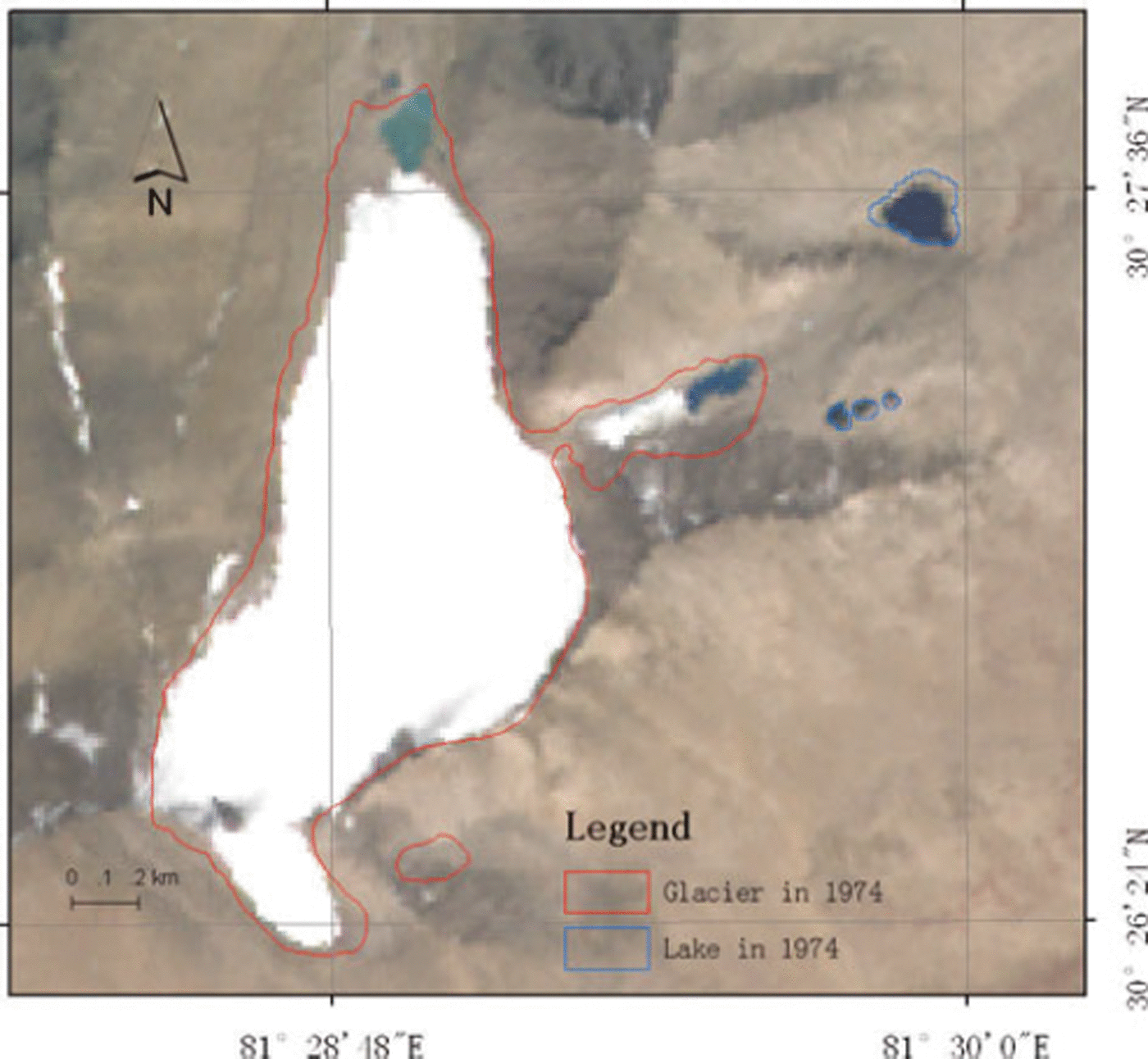
An example of spatial variations in the glacier and the proglacial lake in the southern part of the Mapam basin. The image is the 2003 ASTER image, the red curve indicates the margin of the glacier and the blue curve indicates the lake shore, both in 1974.
Results of variations in the total glacier and lake areas in the Mapam basin from 1974 to 2003 are shown in Figure 3. The total glacier and lake areas in 1974 were 108 and 782 km2, respectively, occupying 1.4% and 10.0% of the basin area. It is clearly seen in Figure 3 that the glacier area decreased monotonically during the period, and the rate of glacier retreat increased from 0.20 km2 a−1 (1973–90) to 0.32 km2 a−1(1990–99) and 0.36 km2 a−1 (1999–2003).
Variations in the total glacier/lake areas and their change rate in the Mapam basin from 1974 to 2003.

Lake variations were more complicated. The total lake area decreased between 1974 and 1999, and slightly increased from 1999 to 2003. Lake area decreased by 22.87 km2 from 1974 to 1990 (with lake decrease amounting to 27.24 km2 in some areas and lake growth to 4.37 km2 in others), decreased by 13.92 km2 from 1990 to 1999 (with lake decrease amounting to 19.33 km2 in some regions and lake growth to 5.41 km2 in others), then increased by 2.63 km2 from 1999 to 2003 (with lake decrease amounting to 8.94 km2 and lake growth to 11.57 km2). The change rate of the total lake area became very negative, at −1.43 km2 a−1 (1973–90) and −1.55 km2 a−1(1990–99), then changed sign to +0.66 km2 a−1 (1999–2003). The lake area enlargement in the last period could not compensate for the lake area reduction in the earlier periods, which is similar to the change reported in the Yamzhog basin (Reference Ye, Zhu, Zheng, Naruse, Zhang and KangYe and others, 2007). The change rate in receded lake area increased, from 1.70 to 2.15 to 2.24 km2 a−1 from 1974 to 1990 to 2003, while for the expanded areas the change rate increased from 0.27 to 0.60 to 2.89 km2 a−1 (Fig. 3). Overall, athough the total glacier area retreat (7.53 km2) was much smaller than the total lake area reduction (34.16 km2), the glacier change by percentage of the total (−7.0%) was more significant than that of lakes (−4.4%).
Glacier and lake variations in the Mapam basin also show spatial differences during 1974–2003. Figure 4 shows glacier and lake variations in the northern and southern parts of the basin. Extensive glacier retreat occurred in the Gangdisá mountains (9.9% retreat of the total 39 km2), where the smaller glaciers were dominant (Fig. 4a), occupying 36% of the total glacier area in the basin; whereas in the western Himalaya, where the larger glaciers dominated (Fig. 4b), occupying 64% of the total glacier areas in the basin, glaciers retreated only 3.14 km2 (4.6% of the total 69 km2). Therefore, the smaller glaciers retreated relatively faster than the larger ones. Moreover, advancing glaciers were only located in the southern basin (Fig. 4b).
Spatial variations of glaciers and lakes during 1974–2003: (a) northern Mapam basin, and (b) southern Mapam basin (area in km2).

Glaciers located on steep slopes (≥25°) were smaller in area (in total 24 km2) and retreated (2.38 km2, or 9.7%) more dramatically than larger glaciers on gentle slopes (retreat by 5.25 km2, or 6.3% of the total 38 km2). Similarly, with regard to different aspects of glaciers in the western Himalaya, glaciers located on south, southeast and east aspects, which were smaller in total area (3.28, 1.81, 11.63 km2, respectively), retreated 6.19%, 7.95% and 6.18%, respectively; more dramatically than the larger glaciers on north or west aspects (retreat 3.86% of the total 9.14 km2 and 3.12% of the total 8 km2, respectively). At elevations between 5400 and 5700 m a.s.l., glacier retreat rate was larger (∼8% of the total 36.57 km2) than at other elevations. As to lakes, smaller lakes in the northern basin (reduced in some areas by 61%, but enlarged in others by 13%, of the total 1.3 km2) changed more than those in the southern basin (reduced by 44%, or enlarged by 8.3% of the total 7.36 km2). Smaller lakes in the north and south basins changed more markedly than larger lakes: the three big lakes, which covered 771 km2 in total and occupied 98.6% of the lake area in the basin, including Mapam Yumco, Lánga Co and Kunggyu Co, reduced by 4% and enlarged by 0.4%.
We now compare glacier and lake variations with changes in climate over the past 30 years. Using meteorological data from Burang station to the southwest of the Mapam basin (Fig. 1), Figure 5 shows time series in each study period of average summer (April to October) air temperature, T s; annual mean air temperature, T m; average annual precipitation, P a; average annual lake evaporation, E (obtained by multiplying by a factor 0.6 the annual evaporation rate measured daily with a 20 cm evaporation pan); average terrestrial evapo-transpiration of the basin, E a, calculated from P a and potential evapo-transpi ration in the basin, ET, using the Bagrov model (Reference DoogeDooge, 1992); the average annual residual water in lakes, P a−E (vertical water flux); and average annual runoff from precipitation, R a (approximated by P a−E a). During 1973–2003, T s and T m rose by 0.7 and 0.8°C, respectively. This warming trend, along with reduced P a, has resulted in negative mass balances on the glaciers, leading to accelerated glacier recession in the Mapam basin during the past 30 years. Although the hydrological parameters which affect lake changes are generally quite complicated, water balance of a lake can be expressed as
where ΔW is the change of water storage in a lake, P is annual lake precipitation, R is the inflow of water consisting of R a, R g (from glacier melting) and R f (from frozen ground melting), and δ is factors due to other effects which include groundwater flow. Here we assume P a = P and ET = E because of limitations of the available data. Units of all parameters in the equations are millimetres.
Averaged meteorological data from Burang station and the calculated hydrological parameters in three periods from 1973 to 2003 in the Mapam basin.
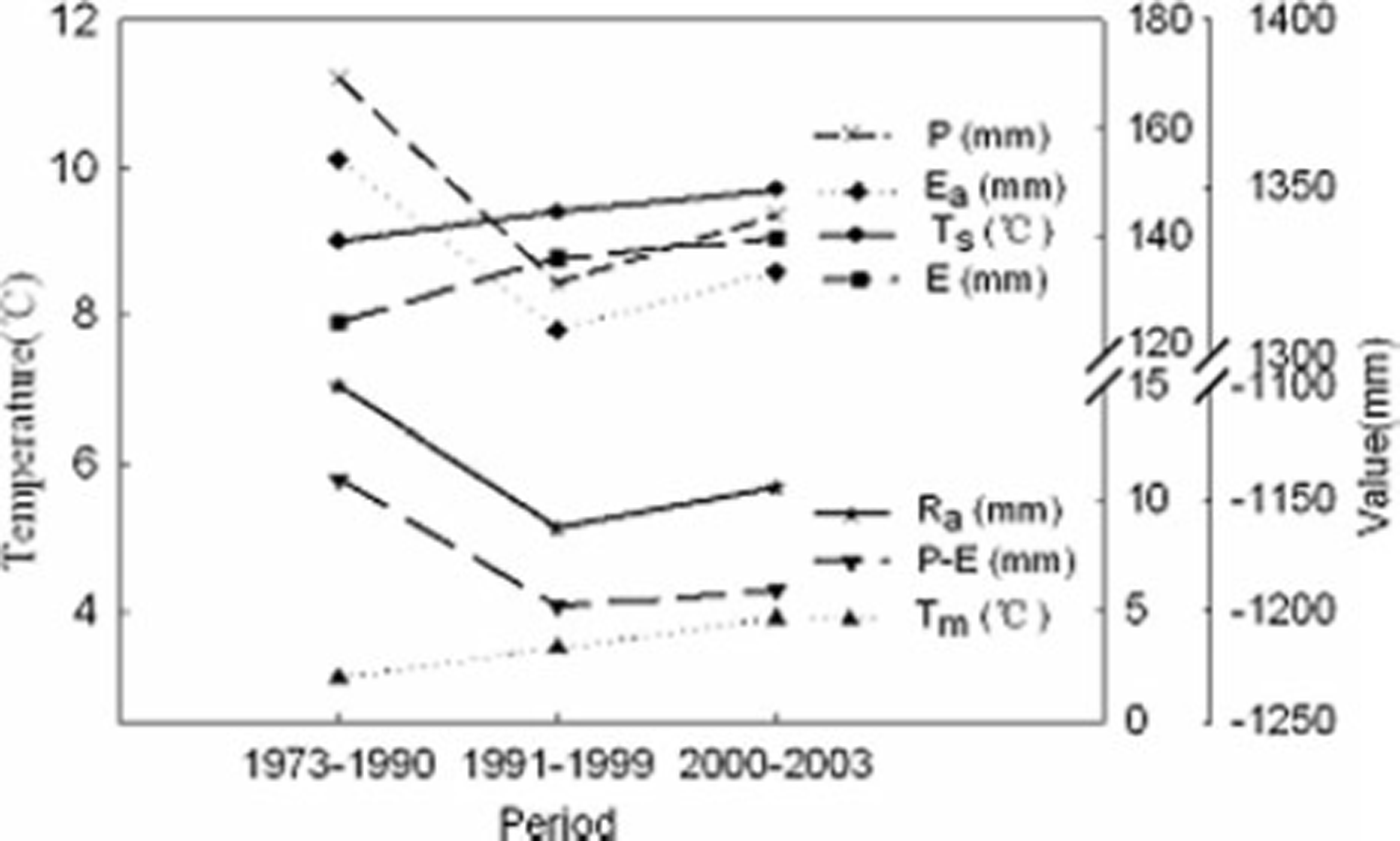
Figure 5 indicates that P − E decreased 57 mm from 1973–90 to 1991–99, due to a decrease in P and an increase in E. R a also decreased by 6 mm synchronously. Therefore, the lake reduction in the basin during 1974–99 was most likely due to the large decrease in P−E, combined with decreased R a. In 2000–03, both P−E and R a increased to some extent, which may have caused a slight lake area enlargement. The P−E and R a did not reach their values of 1973–90, which may be the main reason that the enlargement in lake area in 2000–03 did not compensate for the lake area decrease in 1974–99. A similar change was observed in the Yamzhog basin.
In addition to R a, the inflows R g and R f also contribute to lake changes. Lake enlargement in 2000–03 may have been enhanced by increased R g and R f due to warming. However in the basin during 1974–2003, melting water from the total retreat of glaciers by 7.53 km2 (0.26 km2 a−1 or 0.25% a−1) may not have contributed enough water to lakes because lake area reduced 34.16 km2 in total synchronously. Regional in situ hydrological data are required for further quantitative study of water balance in the basin (e.g. lake water change, ΔW, or lake water-level variations, runoff from melting of snow cover, glaciers and frozen ground).
The glacier recession rate, 0.25% a−1, in 1974–2003 in the Mapam basin was smaller than the 0.31% a−1 in the Naimona’nyi region during 1976–2003 (Reference Ye, Yao, Kang, Chen and WangYe and others, 2006a). It was almost comparable with the 0.18% a−1 mean glacier recession in China since the 1960s (Reference Yao, Wang, Liu, Pu, Shen and LuYao and others, 2004), both of which were much larger than the 0.07% a−1 (retreat by 3 km2 in total, or 0.15 km2 a−1) in the Yamzhog basin.
Our results show that both glacier and lake areas in the Mapam basin decreased from 1974 to 2003. Lake area reduction by 34.16 km2 was significant due to the large decrease in P−E and R a, similarly to the findings in the Yamzhog basin. Increased melting of glaciers and frozen ground in the basin is also considered to have contributed to the lake enlargement in 1974–2003; however, the total glacier recession by 7.53 km2 did not supply enough water for lake growth to compensate for lake reduction in the same period. In the Mapam basin, both enlargement and reduction of lakes accelerated in 1974–2003, which may be an indicator of an accelerated water-cycle process over the Tibetan Plateau forced by warming climate.
Acknowledgements
This work was supported by the National Natural Science Foundation of China (40601056, 40121101), by Opening Fund projects of the State Key Laboratory of Remote Sensing Science in the Institute of Remote Sensing Applications and by the innovative project of the Institute of Tibetan Plateau Research (ITPR), Chinese Academy of Sciences. We thank H. Zheng, W. Zheng, W. Yang, F. Chen, J. Cui and L. Guo for their help. We are grateful to the Chief Editor, T.H. Jacka, and two anonymous reviewers for helpful comments on the manuscript.
8 August 2008


