

INTRODUCTION
In 1912, Merwin and two colleagues from Harvard's Peabody Museum conducted the first modern archaeological reconnaissance of southern Quintana Roo, then a sparsely populated Mexican territory dotted with chiclero camps and exploited by foreign logging companies. Following their arrival in Payo Obispo (modern-day Chetumal), Merwin's team explored the areas around the Bahía de Chetumal, the Laguna de Bacalar, and the Río Hondo, as well as zones further west in southernmost Quintana Roo and southeastern Campeche. In his doctoral dissertation, Merwin (Reference Merwin1913) described the ruins he encountered at a number of sites, most notably Clarksville (Kohunlich) and Río Beque (Río Bec). Nevertheless, Merwin's descriptions suggested that the archaeological remains in this region were, on the whole, unimpressive. Based largely on the word of local informants, he concluded that no significant ruins occurred around the Bahía de Chetumal or the Laguna de Bacalar (Merwin Reference Merwin1913:4–8). Moreover, the explorers encountered only a limited number of temples, all of modest size, one or two acropolises, two altars, and no carved stelae (although five uncarved examples were found) (Merwin Reference Merwin1913:134–136, 176–177, 184). Despite evidence of a sizable population in the western part of the reconnaissance area, Merwin (Reference Merwin1913:133–136) interpreted the relative absence of impressive architecture and monuments as evidence that “there had been no strong centralized organization” in this region, particularly in comparison to the great Maya centers in Guatemala, Honduras, and northern Yucatan. His conclusions implied that southern Quintana Roo was a marginal or peripheral region in the Maya world—a characterization that accorded with, and reinforced, models of Maya civilization that posited an earlier, Classic apogee in the central lowlands and a later, Postclassic florescence in northern Yucatan (Nalda and Velázquez Reference Nalda, Velázquez and Morlet2000:19–20; Velázquez Morlet Reference Velázquez Morlet and Morlet2000:5).
Merwin's work marks the beginning of a century-long period during which the archaeological remains in Quintana Roo have been characterized inaccurately. Although the entire state of Quintana Roo has traditionally been neglected in Maya scholarship, as Shaw and Mathews (Reference Shaw, Mathews, Shaw and Mathews2005a) note, we argue that the southern half of the state has been most severely ignored or mischaracterized. Maps of the Maya lowlands published in both scholarly and popular sources typically depict southern Quintana Roo as a sort of no-man's-land devoid of ancient settlement, or at least sites large or significant enough to merit inclusion on a map (Harrison Reference Harrison and Ashmore1981:259; Shaw and Mathews Reference Shaw, Mathews, Shaw and Mathews2005a). To be sure, for many decades research in this region lagged behind that conducted in other areas of the Maya lowlands (Nalda Reference Nalda and Morlet2000:47–48; Velázquez Morlet Reference Velázquez Morlet and Morlet2000:5). Data collected since the 1970s, however, demonstrate that the density of settlement in southern Quintana Roo is comparable to that in neighboring regions (Harrison Reference Harrison and Ashmore1981:272; Nalda and Velázquez Reference Nalda, Velázquez and Morlet2000:25) and that this zone is home to many large centers with settlement histories spanning nearly the entire Preclassic to Postclassic sequence. Despite this archaeological evidence, the apparent gap in ancient Maya settlement depicted on maps is in danger of becoming reified, if this has not already occurred. One cannot help but conclude (or assume) that this recurrent “blank spot” (Shaw and Mathews Reference Shaw, Mathews, Shaw and Mathews2005a:3) was, indeed, sparsely populated and, thus, peripheral to regions in which more significant cultural, political, and economic developments occurred (Velázquez Morlet Reference Velázquez Morlet and Morlet2000:5).
We certainly would not argue that sites in southern Quintana Roo were more important than those in other parts of the Maya area. At the same time, we suggest that southern Quintana Roo was not marginal or peripheral culturally, politically, or even geographically (Nalda Reference Nalda and Morlet2000:69, Reference Nalda, Shaw and Mathews2005:243–244; see also Shaw and Mathews Reference Shaw, Mathews, Shaw and Mathews2005a). In light of the growing body of available data, it seems more fruitful to characterize this region as transitional between the central lowlands and the northern portion of the Yucatan peninsula, and to focus on how developments in southern Quintana Roo were related to those elsewhere. By doing so, we recognize that this region played significant roles in Maya history and, thus, merits incorporation into large-scale models of the development of ancient Maya civilization. At the same time, we concur with Nalda (Reference Nalda, Shaw and Mathews2005:243) that the unique patterns in the archaeological record of southern Quintana Roo are interesting in their own right and cannot be understood simply by extrapolating from neighboring regions. As Mayanists have increasingly recognized, it is essential that we document local histories and regional variability in subsistence/economic systems, cultural practices, and sociopolitical phenomena such as the so-called Classic “collapse” (e.g., Aimers Reference Aimers2007; Demarest Reference Demarest2005; Iannone Reference Iannone2014; Rice et al. Reference Rice, Demarest, Rice, Demarest, Rice and Rice2004; Stanton and Magnoni Reference Stanton and Magnoni2008).
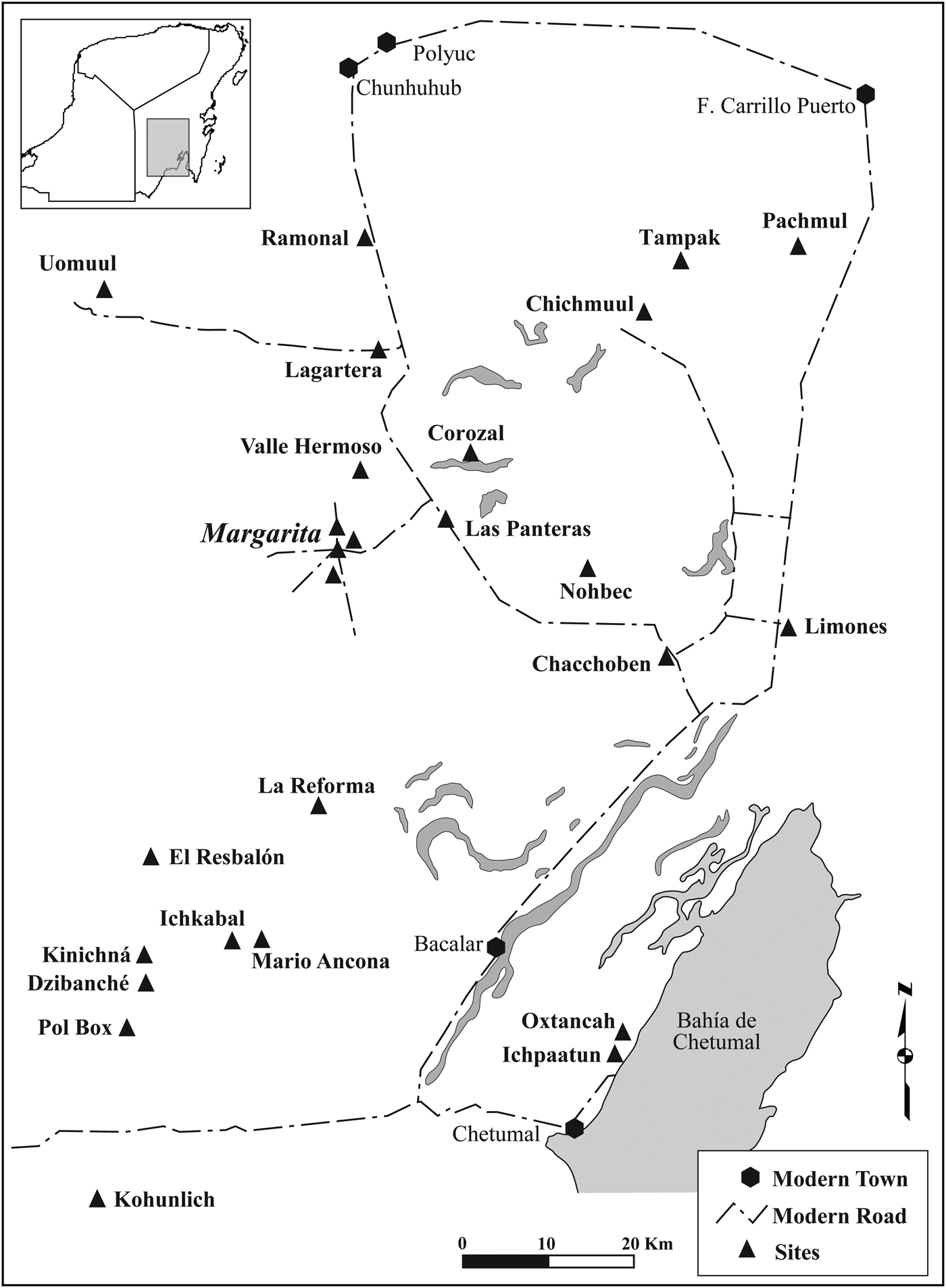
In this paper, we present the results of research at Margarita, a medium-sized center located in south-central Quintana Roo (Figure 1). In particular, we describe the intensive excavations that were conducted at the site in 2008 and 2010–2011. In order to contextualize our research at Margarita, we also review data from our earlier investigations at the larger, neighboring site of Lagartera, as well as the results of recent projects undertaken by the Instituto Nacional de Antropología e Historia (INAH) at Dzibanche-Kinichna, Kohunlich, El Resbalón, Pol Box, Chacchoben, and Ichkabal (Figure 1). We also incorporate data from the Uaymil Survey Project directed by Peter Harrison in the early 1970s. We focus on the interior (south-central) portion of Quintana Roo and, thus, do not deal explicitly with the coast or the area around the Bahía de Chetumal. Other recent publications provide synopses of investigations conducted in those areas (Con Uribe Reference Con Uribe, Shaw and Mathews2005; Vega Nova et al. Reference de Vega Nova, Sánchez, Ortiz and Morlet2000; Guderjan Reference Guderjan, Shaw and Mathews2005; see also Sanders Reference Sanders1960).
Map of south-central Quintana Roo showing the location of archaeological sites. Map by Villamil.
There are now sufficient data from sites in the southern half of Quintana Roo to outline the basic demographic and sociopolitical history of this region, the roles played by variously sized centers in its geopolitical landscape, and its relationship with the greater Maya world. As we detail below, following initial colonization of the region in the Middle Preclassic (1000–400 b.c.), the Late Preclassic (400 b.c.–a.d. 250) to Early Classic (a.d. 250–600) witnessed the growth of large centers and the development of regional settlement hierarchies, with sites throughout the region exhibiting strong architectural and ceramic ties to the Petén region of northern Guatemala. During the Late Classic (a.d. 600–800), there was a significant reconfiguration of the geopolitical landscape; the decline of several larger centers was accompanied by a relative increase in the number, size, and importance of smaller centers composed largely of elaborate residential groups. While certain cultural conventions (e.g., architectural styles) continued to link sites throughout the region, the Late Classic was also characterized by pronounced ceramic regionalization and a growing affiliation with northern Yucatán. Similar to patterns documented throughout the southern and central lowlands, many centers in south-central Quintana Roo were abandoned in the Terminal Classic (a.d. 800–1000). At Margarita and several other sites, however, there is also clear evidence—including extensive modification of Late Classic architecture, as well as the construction of modest platforms, house foundations, and other features—that indicates Terminal Classic reoccupations and the generation of “post-collapse” communities.
ARCHAEOLOGICAL RESEARCH IN SOUTH-CENTRAL QUINTANA ROO
Merwin's descriptions of the ruins in southern Quintana Roo were augmented by several explorers who traversed the region in the 1920s and 1930s. The English doctor Thomas Gann “discovered” and documented various sites, including Dzibanche, Kinichna, and Chacna (El Resbalón), in 1927–1931. This was followed soon after by two Mexican expeditions led by César Lizardi Ramos and Alberto Escalona Ramos. Decades later, from 1968 to 1978, Víctor Segovia Pinto directed intensive excavations at Kohunlich, the first major project conducted by INAH in southern Quintana Roo (Nalda Reference Nalda and Morlet2000:45–46; Nalda and Velázquez Reference Nalda, Velázquez and Morlet2000:20–23; Velázquez Morlet Reference Velázquez Morlet and Morlet2000:8–12).
These early explorations highlighted the density of sites, including various large centers, in southernmost Quintana Roo. Knowledge of the archaeological landscape to the north, in the central interior of the state, however, remained limited until the Uaymil Survey Project, directed by Harrison (Reference Harrison1973, Reference Harrison, Hammond and Willey1979, Reference Harrison and Ashmore1981, Reference Harrison, Shaw and Mathews2005) in the early 1970s. Covering much of south-central Quintana Roo, Harrison's team registered 110 sites and produced partial maps of 26 of them. The Uaymil Survey also demonstrated that the density of ancient settlement in southern Quintana Roo is comparable to that in the Petén (Harrison Reference Harrison and Ashmore1981:272). In conjunction with the survey and mapping, Fry undertook a test excavation program and ceramic study. Based on data from 15 sites, he outlined the first ceramic sequence and settlement chronology for south-central Quintana Roo (Fry Reference Fry1973, Reference Fry, Rice and Sharer1987).
In 1993, major INAH projects were initiated at Dzibanche-Kinichna and Kohunlich under the direction of Nalda (e.g., Campaña Reference Campaña1995; Nalda Reference Nalda1998, Reference Nalda and Morlet2000, Reference Nalda and Nalda2004a, Reference Nalda2004b, Reference Nalda2004c, Reference Nalda, Shaw and Mathews2005; Nalda and Balanzario Reference Nalda and Balanzario1997; Nalda and López Camacho Reference Nalda and Camacho1995; Nalda and Velázquez Reference Nalda, Velázquez and Morlet2000; Villamil Reference Villamil1995). Projects have also been conducted by Mexican researchers at neighboring sites, notably El Resbalón (Carrasco and Boucher Reference Carrasco, Boucher, Berlin and Proskouriakoff1987; López Camacho and Tsukamoto Reference López Camacho, Tsukamoto, Laporte, Arroyo, Escobedo and Mejía2003; Tsukamoto Reference Tsukamoto2005, Reference Tsukamoto2006), Pol Box (Esparza Olguín and Pérez Gutiérrez Reference Esparza Olguín and Gutiérrez2009), Chacchoben (Romero Reference Romero R. and Morlet2000), and, most recently, Ichkabal (INAH 2009) (Figure 1).
Investigations at Margarita
Margarita is located approximately 70 kilometers northwest of Chetumal, in the Lakes Region of south-central Quintana Roo (Figure 1). This area lies within the Quintana Roo Depression (Dunning et al. Reference Dunning, Beach, Farrel and Luzzadder-Beach1998), a hydrological region characterized by a mosaic of upland forest zones interspersed with poorly drained depressions. These depressions contain various large, seasonally inundated bajos, shallow perennial wetlands, and a number of small lakes. Like most sites in this region, the main architectural complexes at Margarita are located in upland zones adjacent to the edges of bajos. These bajos may have been important sources of water and other wetland resources, particularly in the Middle to Late Preclassic. Permanent lakes are not present in the vicinity of the site, but water could also have been obtained from deep wells and, during the rainy season, wetlands and aguadas. In addition to partially stone-lined wells found in Margarita's central complex and the modern village (Harrison Reference Harrison, Scarborough and Isaac1993:78–81, Figures 4–5; Villamil Reference Villamil2009:71, Figures 4.43 and 4.45), local farmers have reported similar wells in their fields, some still containing water. Harrison (Reference Harrison, Scarborough and Isaac1993:78) also documented comparable wells at Chacchoben and Chichmuul during the Uaymil Survey (Figure 1). Based on Late Postclassic water storage vessel fragments recovered in association with the wells, Harrison (Reference Harrison, Scarborough and Isaac1993:78) argued that these features were “of ancient construction” and that “as late as the 12th century, such wells were still functioning as a water source.” At this time we do not have any additional data that corroborate or refute Harrison's proposition. Even if the wells are indeed ancient, it is likely that water storage facilities and management techniques were needed to sustain the large populations who inhabited the Margarita locality in pre-Hispanic times (Villamil Reference Villamil2009:8–14).
Margarita was first registered by Harrison (Reference Harrison and Ashmore1981:273), who identified it as one of five possible “major or primary centers” in the Uaymil Survey zone. Harrison (Reference Harrison and Ashmore1981) named the site Margarita Maza de Juárez, after the ejido in which the site is located. Present-day inhabitants, however, refer to their village and ejido simply as “Margarita,” so we have adopted this shortened form for the site name. Our more recent and intensive investigations at Margarita constitute part of a long-term research program—the Proyecto Arqueológico Centro de Quintana Roo (PACQR)—initiated in 1998. Focusing on the sites of Margarita and Lagartera, the original objectives of the PACQR were: (1) to extend archaeological research north of the major INAH projects in the south, thereby building upon the results of the Uaymil Survey and enhancing our understanding of the basic culture history of sites in south-central Quintana Roo; and (2) to investigate the variety of urban forms present in this region and the ways in which political strategies may have shaped those urban configurations. Thus, in 2000–2002 a survey, mapping, and test excavation program was undertaken at Margarita and Lagartera in order to document the built environments and histories of occupation at these sites (Villamil Reference Villamil and Yoffee2007, Reference Villamil2009; Villamil and Sherman Reference Villamil, Sherman, Shaw and Mathews2005).
The research conducted at Margarita in 2000 demonstrated that it is a medium-sized center composed of four distinct monumental complexes spaced two to three kilometers from each other (Figure 2). Margarita thus represents a recurrent site pattern in southern Quintana Roo—first noted by Harrison (Reference Harrison and Ashmore1981:272–273) and subsequently discussed by Nalda (Reference Nalda1998, Reference Nalda and Morlet2000)—in which large sites are composed of multiple, spatially segregated architectural complexes. Other sites exhibiting this pattern include Corozal, Panteras, and Valle Hermoso in the north, and Dzibanche (Nalda Reference Nalda1998, Reference Nalda and Morlet2000), El Resbalón (López Camacho and Tsukamoto Reference López Camacho, Tsukamoto, Laporte, Arroyo, Escobedo and Mejía2003), and Pol Box (Esparza Olguín and Pérez Gutiérrez Reference Esparza Olguín and Gutiérrez2009) in the south.
Maps of the central complex (A), eastern complex (B), and southern complex (C) at Margarita. Map by Villamil.

The three complexes that we mapped at Margarita (Complexes A, B, and C) included 242 structures ranging between 1 and 17 m in height spread across a total area of approximately 42 hectares. Local politics prevented us from fully investigating the northern complex (Complex D), although we were allowed to excavate one test pit in the center of this complex (see below). Notably, most of the mounds at the site constitute elaborate patio groups. In contrast with neighboring centers like Lagartera, Chacchoben, and Chichmuul (Figure 1), there appears to be a relative lack of larger civic-ceremonial architecture at Margarita, suggesting that it was a fundamentally different kind of site—one that was more residential, and less administrative or ritual, in nature. In addition to the larger mounds at Margarita, we also located and mapped 389 modest features, including house foundations, low platforms, albarradas (walls), chultunes, wells, and quarries. Moreover, to collect chronological data, we excavated 56 test pits across all four of the complexes at Margarita. The ceramics recovered in these test excavations indicated that the history of occupation at the site was quite long, spanning from the Middle Preclassic to the Terminal Classic.
2008–2011 Excavations
Our excavations at Margarita in 2008 and 2010–2011 were designed to evaluate the hypothesis—stemming from earlier work at the site—that the patio groups so abundant at Margarita were primarily residential in function, and occupied by affluent and/or high-status families during the Late Classic. We also wanted to test the proposition that the site was abandoned but then reoccupied in the Terminal Classic, and that the modest features scattered across the surface of the site pertain to this phase of reoccupation.
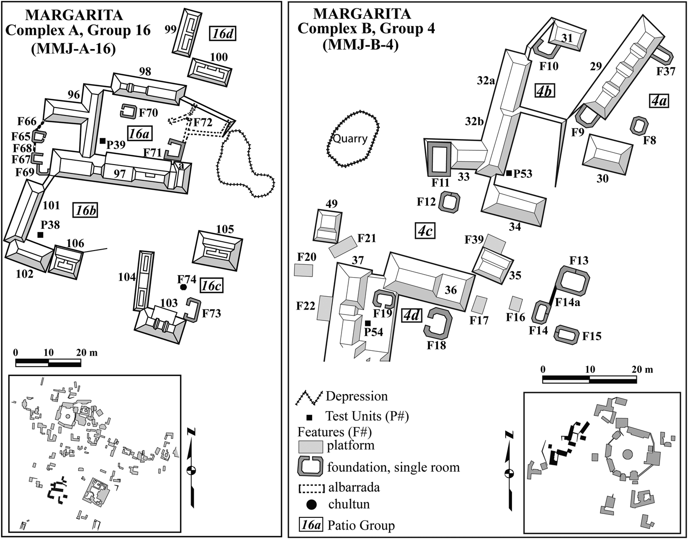
Our excavations in 2008 focused on Patio Group 6a, located near the northern edge of the central complex (Complex A; see Figure 3). We selected this group because it is relatively modest in scale. Ultimately, we are interested in the range of variation among patio groups at Margarita and, based on surface data, Patio Group 6a appeared to be representative of the lower end of a size continuum. We also chose this group because it contains seven of the modest architectural features that we believe are evidence of a Terminal Classic reoccupation. Our excavations included three main operations: exposure of the remains of Structure 47, a series of test pits around the perimeter of the group, and a shallow trench through one of the modest features in the patio (Figure 4).
Detailed map of Complex A at Margarita. Map by Villamil.

Map of Patio Group 6a showing the location of excavations. Map by Villamil.

In 2010–2011 we conducted excavations in Patio Group 4b, a quadrangle composed of several contiguous mounds delimiting a small raised courtyard (Figure 3). This group is situated entirely within another, larger group (Patio Group 4a). Thus, it is an example of what Harrison (Reference Harrison and Ashmore1981:281) termed a “contained quadrangle,” a distinctive architectural type found at many sites in the region. Given its central location, its association with some of the largest civic-ceremonial structures at the site (which, again, are few and far between), and the fact that access to this group was so restricted, we suspected that Patio Group 4b was the residence of one of the wealthiest and/or highest-status families at Margarita. In addition, four test pits excavated in or near Patio Group 4b in 2000 revealed the longest occupational sequence documented at Margarita. Two of the pits yielded the only unmixed Middle Preclassic ceramics found at the site, suggesting that the earliest settlement began in this area. Furthermore, two units excavated inside the patio group cut through as many as five superimposed floors, yielding ceramic assemblages spanning from the Late Preclassic to the Terminal Classic. Thus, this area of Margarita appeared to have been a focus of significant occupation and construction activity throughout the site's entire history. The excavations we conducted in 2010–2011 focused on the southern and eastern sides of the quadrangle (Structures 23a–23d) and a circular platform (Structure 22) in the middle of the patio (Figure 5). We also excavated sondages inside and adjacent to these buildings in order to collect additional data on the developmental history of the group. In the following sections we provide an overview of the ceramics found at Margarita and neighboring sites, outline the history of settlement at Margarita, and discuss in detail the results of our excavations in Patio Groups 4b and 6a.
Map of Patio Group 4b showing the location of excavations. Map by Villamil.

CERAMICS AND SETTLEMENT HISTORY AT MARGARITA
Middle Preclassic to Early Classic
Small assemblages of Middle Preclassic pottery found at various sites indicate that south-central Quintana Roo was initially colonized during this period. At Margarita, Middle Preclassic sherds were found in fill at the bottom of deep test pits excavated in and around Patio Group 4b in 2000 and 2010–2011, as well as in the single test pit excavated in the site's northern complex (Complex D; Villamil Reference Villamil2009:45, 97, 113). Small assemblages of Middle Preclassic pottery have also been recovered at Lagartera (Villamil Reference Villamil2009:21, 107–108), Dzibanche (Nalda Reference Nalda, Shaw and Mathews2005:236), Kohunlich (Nalda Reference Nalda2004b:59–62, Reference Nalda, Shaw and Mathews2005:229), El Resbalón (Carrasco and Boucher Reference Carrasco, Boucher, Berlin and Proskouriakoff1987:6), Pol Box (Esparza Olguín and Pérez Gutiérrez Reference Esparza Olguín and Gutiérrez2009:6), and Uomuul (Fry Reference Fry, Rice and Sharer1987:113).
The earliest pottery from Margarita and Lagartera includes widespread Mamom sphere types (e.g., Joventud Red, Chunhinta Black, Pital Cream, and Muxanal Red-on-cream) as well as Sapote Striated:Añejo variety (Ball Reference Ball1977:10–13); vessel forms include bowls, basins, tecomates, jars, and bolstered-rim bottles (Villamil Reference Villamil2009:157, 176–177). Joventud Red, Chunhinta Black, and Pital Cream are found as far north as Uomuul (Fry Reference Fry, Rice and Sharer1987:113). To the south, varieties of Joventud and Chunhinta were identified at El Resbalón (Carrasco and Boucher Reference Carrasco, Boucher, Berlin and Proskouriakoff1987:6, 20). Likewise, several Joventud and Pital varieties, among other types, are represented in the assemblage from Kohunlich (Nalda Reference Nalda2004b:91).
Overall, the ceramic evidence suggests low population densities in dispersed hamlets or villages, but essentially nothing is known about architecture or the size or organization of settlements during this period. Nalda (Reference Nalda2004b:59, Reference Nalda, Shaw and Mathews2005:229) notes, however, that Middle Preclassic material is concentrated around aguadas and bajos at Kohunlich. Likewise, the location of Margarita and other neighboring sites near the edges of bajos may reflect a focus on access to water by the earliest inhabitants of the region.
The abundance of Late Preclassic ceramics at sites throughout south-central Quintana Roo attests to the intensified and widespread nature of Late Preclassic occupation in the region. This pottery—which includes Paso Caballo waxy wares (Sierra Red, Polvero Black, and Flor Cream) and Sapote Striated (Sapote and Rastro varieties) (Carrasco and Boucher Reference Carrasco, Boucher, Berlin and Proskouriakoff1987:6; Fry Reference Fry, Rice and Sharer1987:113–114; Nalda Reference Nalda2004b:91–92; Villamil Reference Villamil2009:158–162, 178)—clearly belongs to the Chicanel sphere, and indicates participation in the social and economic interaction networks that linked much of the Maya lowlands during the Late Preclassic. At the same time, some minor intraregional differentiation is discernible. In addition to the Sierra variety of Sierra Red, an orangish-red (Maza) variety of Sierra is common at Margarita and other sites in the northern portion of the Uaymil Survey area (Fry Reference Fry, Rice and Sharer1987:113) but rare in the south (e.g., El Resbalón [Carrasco and Boucher Reference Carrasco, Boucher, Berlin and Proskouriakoff1987:6]). Not surprisingly, the southernmost sites exhibit ceramics ties to northern Belize (Fry Reference Fry, Rice and Sharer1987:114). Moreover, Carrasco and Boucher (Reference Carrasco, Boucher, Berlin and Proskouriakoff1987:6) suggest that the Huachinango group ceramics found at El Resbalón are evidence of economic links to the Yucatán/Quintana Roo coast.
Late Preclassic ceramics were recovered at 11 of the 15 sites tested during the Uaymil Survey Project, including Dzibanche, Chacchoben, Margarita, Panteras, and Uomuul (Fry Reference Fry, Rice and Sharer1987:113–114). This material was recovered primarily from fill beneath plaza floors, leading Fry (Reference Fry, Rice and Sharer1987:113) to conclude that there was “substantial construction at public architectural loci during this time span.” The results of more recent investigations likewise indicate population increase and the initiation of monumental construction projects at various sites in south-central Quintana Roo during the Late Preclassic.
Eleven of the 34 test pits excavated in the central complex at Margarita, as well as the more intensive excavations in Patio Group 4b, yielded Late Preclassic ceramics (Villamil Reference Villamil2009:113). Some of these deposits were associated with the construction of plaza floors and presumably adjacent buildings. Test excavation data also indicate that construction of the acropolis may have begun at this time. This monumental structure consists of a massive (88 m × 77 m × 6 m), multilevel platform topped by various buildings surrounding a central plaza and two sunken courtyards (Figure 3). The uppermost buildings—undoubtedly temples—are arranged in a triadic pattern. Triadic constructions are common at sites in southern Quintana Roo and they appear to date to the Late Preclassic to Early Classic (Nalda Reference Nalda, Shaw and Mathews2005:236). In addition to its monumentality, the location of the acropolis suggests that it was one of the most important ceremonial foci at Margarita. It was constructed on a natural hill (the highest point at Margarita) and directly above a small cave, the mouth of which is located at the northeast corner of the platform's base (Villamil Reference Villamil2009:68–69). The association between this landscape feature and largest architectural complex at Margarita surely is not coincidental, given the importance of caves in the cosmologies of the Maya and other Mesoamerican societies. The Maya believed caves and other openings in the earth, such as cenotes, were passages to the underworld. As such, they were important pilgrimage sites and ritual loci, and architectural complexes were often built on top of them (Bassie-Sweet Reference Bassie-Sweet1991, Reference Bassie-Sweet1996; Brady Reference Brady1997; Brady and Ashmore Reference Brady, Ashmore, Ashmore and Knapp1999; Carlson Reference Carlson and Benson1981; Demarest et al. Reference Demarest, Morgan, Wolley, Escobedo and Christie2003; Heyden Reference Heyden and Benson1981; UNAM 2015; Vogt Reference Vogt and Benson1981). In sum, our current evidence suggests that the central complex at Margarita may have been emerging as a minor civic-ceremonial center by the Late Preclassic. Test excavations also indicate at least modest occupation in the other three complexes at the site (Villamil Reference Villamil2009:115–117).
We have found examples of Protoclassic pottery—including Ixcanrio Orange Polychrome, vessels with hollow mammiform supports, and possibly imitation Usulutan—at both Margarita and Lagartera (Villamil Reference Villamil2009:23, 109, 179). The limited quantity of this material has thus far prevented us from defining distinct Protoclassic occupations. Nevertheless, its presence suggests that settlement at both sites was continuous from the Late Preclassic into the Early Classic. Appreciable quantities of Protoclassic pottery have also been recovered at Kohunlich, where researchers have successfully defined a Protoclassic occupation similar in size and distribution to that of the Late Preclassic (Nalda Reference Nalda2004b:62–63, 91–92). The limited amount of Protoclassic pottery recovered during the Uaymil Survey, exclusively at Dzibanche, indicates ties between sites in the southeastern portion of the survey zone and northern Belize (Fry Reference Fry, Rice and Sharer1987:114).
In the Early Classic, population increase and monumental construction continued throughout southern Quintana Roo. Early Classic pottery recovered at Margarita, Lagartera, Kohunlich, El Resbalón, and other sites includes Petén Gloss Wares (particularly Aguila and Balanza groups, including a distinctive orange-black dichrome, as well as some Dos Arroyos Orange Polychrome) and Triunfo Striated vessels, indicating participation in the Tzakol ceramic sphere (Carrasco and Boucher Reference Carrasco, Boucher, Berlin and Proskouriakoff1987:6; Fry Reference Fry, Rice and Sharer1987:114–115; Nalda Reference Nalda2004b:92–93; Villamil Reference Villamil2009:23, 45, 163–164, 180–182). As in the Late Preclassic to Protoclassic, the southernmost sites exhibit strong links to the south, including northern Belize (Fry Reference Fry, Rice and Sharer1987:115). Thin-walled jars with trickle decoration, indicating associations with regions to the west and north, are also common at sites in south-central Quintana Roo and may begin in the Early Classic (Carrasco and Boucher Reference Carrasco, Boucher, Berlin and Proskouriakoff1987:6, 20; Fry Reference Fry, Rice and Sharer1987:114). Stratigraphic evidence from Margarita, Lagartera, and Kohunlich, however, indicates that similar vessels with trickle decoration continued into the Late Classic, and perhaps even the Terminal Classic (Nalda Reference Nalda2004b:95–98).
Although it was clearly secondary to Lagartera (see below), Margarita continued to grow in the Early Classic. Excavations in all four of the site's complexes yielded significant amounts of Early Classic pottery. Construction of plaza floors continued in the central and northern complexes and occurred for the first time in the eastern complex (Complex B; Villamil Reference Villamil2009:45, 113–117). Construction activity in the southern complex (Complex C)—which itself is composed of four spatially discrete architectural groups (Figure 2)—appears to have occurred largely in the Early Classic. The most significant construction was a 1-ha, 4-m-tall platform that supported a pyramid (10 m in height) and five smaller buildings. Two other large, raised plazas were also documented. In contrast to the other complexes at Margarita, at least 11 of the 27 major structures mapped in Complex C appear to be temple platforms or multi-chambered pyramids (see discussion below). Only two possible residential groups were documented. Thus, unlike the other complexes at Margarita, Complex C appears to have been largely ceremonial in function (Villamil Reference Villamil2009:91–96).
Late Classic
Late Classic pottery has been found at sites throughout south-central Quintana Roo. In contrast to previous periods, these ceramics are characterized by considerable regionalization and intersite differentiation (Fry Reference Fry, Rice and Sharer1987:115–116). Continuing ties to the Petén and northern Belize are evidenced by the presence of local varieties of Molino group, Encanto Striated, and Saxche and Palmar Orange Polychromes (both imported and locally imitated), particularly at sites in the southern zone (Carrasco and Boucher Reference Carrasco, Boucher, Berlin and Proskouriakoff1987:7, 20; Fry Reference Fry, Rice and Sharer1987:116–117; Nalda Reference Nalda2004b:94, 96; Villamil Reference Villamil2009:165–167, 184, 187). Other types (e.g., Traino, Becanchen, and Chimbote groups) indicate trade links with Campeche (Carrasco and Boucher Reference Carrasco, Boucher, Berlin and Proskouriakoff1987:7, 20; Fry Reference Fry, Rice and Sharer1987:116–117; Nalda Reference Nalda2004b:94). Waxy monochrome basins with horizontal groove-incised lines on their interior—especially of the local types Herradura Brown-black and Las Moras Red—are also found at sites in the south (Carrasco and Boucher Reference Carrasco, Boucher, Berlin and Proskouriakoff1987:7, 20; Fry Reference Fry, Rice and Sharer1987:116; Nalda Reference Nalda2004b:95, 97) and as far north as Margarita, where they dominate the Late Classic ceramic assemblage (Villamil Reference Villamil2009:183). Sherds from such vessels were also recovered, though less abundantly, at Lagartera, where basins with incurving rim panels and trickle decoration are more common (Villamil Reference Villamil2009:165, 169). Fry (Reference Fry, Rice and Sharer1987:116) notes vessels of similar form at Uomuul (i.e., Uomuul Orange-cream).
The Late Classic was also marked by the appearance of slate wares at sites throughout south-central Quintana Roo, and particularly in the northern zone (Fry Reference Fry1973:489, Reference Fry, Rice and Sharer1987:116–117). The presence of either imported and/or locally produced slate ware vessels indicates shifting ceramic sphere affiliations and a growing association with regions to the north and northwest. Slate wares continued into—and, in fact, became quite common by—the Terminal Classic. Stratigraphic evidence from our excavations at Margarita and Lagartera, however, corroborates Fry's (Reference Fry1973:489, Reference Fry, Rice and Sharer1987:116) assertion that slate wares began to appear in south-central Quintana Roo toward the end of the Late Classic (i.e., they were not restricted to the Terminal Classic). We discuss the slate wares at Margarita and neighboring sites in greater detail below.
Test excavation data indicate that both occupation and building activity, including the construction of plaza and patio floors, in the central and eastern complexes (and perhaps also the northern complex) at Margarita peaked in the Late Classic (Villamil Reference Villamil2009:113–117). The results of our more intensive excavations in Patio Groups 6a and 4b further demonstrate that the Late Classic was a period of major growth marked by the construction of elaborate residential groups.
Patio Group 6a Excavations
The most extensive operation in Patio Group 6a focused on Structure 47 (Figure 6). The lower courses of the eastern wall of the building were well-preserved; the wall measured between one and 1.4 m in width, and was originally plastered on both the interior and exterior. Three large doorways faced east toward the patio. We found no evidence of the structure's back (western) wall, which may have collapsed or been deliberately dismantled (see further discussion below). The southern end of the building had been heavily disturbed by trees, and the northern wall was also poorly preserved. It was possible to trace the building's lowest courses, however, allowing us to estimate that the single interior room of Structure 47 was 14 m long and at least two meters wide.
Plan drawing of Structure 47 and modest stone features excavated in Patio Group 6a. Map by Villamil.

The quality of construction and degree of architectural elaboration on the eastern façade of the building were greater than we had expected given the relatively modest scale of Patio Group 6a. The basal platform, which was about 60 centimeters in height, had rounded corners and consisted of a recessed panel framed above and below by horizontally placed stones (Figure 7). The central portion of the façade projected outward toward the patio and included nicely shaped, rounded architectural elements. Below each of the three doorways were a series of small, vertically set rectangular and cylindrical stones (tamborcillos). In each case, the centermost tamborcillo was carved with a geometric design (Figure 7). Stylistically, Structure 47 was very similar to contemporaneous structures at Kohunlich built in what investigators there have termed the Pixa'an style (Nalda Reference Nalda2004b:46–47, Photos 15–17). Nalda (Reference Nalda2004b:47) notes that this architectural style—also evident in a Late Classic building (Structure 14) at Dzibanche (Nalda Reference Nalda and Morlet2000:59)—is similar to that found at sites in the Chenes region, including Santa Rosa Xtampak and Edzna (see also Nelson [Reference Nelson1973:26, Figure 19] regarding similar architectural forms at Dzibilnocac, Campeche).
Photographs of the eastern façade of Structure 47 and the carved tamborcillos beneath the building's three doorways. Photographs by Villamil.

We uncovered a well-preserved plaster floor inside Structure 47. Two test pits excavated through this floor revealed a second, earlier floor approximately 30 centimeters below the upper surface. A mixture of Early and Late Classic sherds was recovered from the thick layer of rocky fill below the lower floor. In contrast, the thin layer between the lower and upper floors yielded primarily Late Classic pottery. Based on this ceramic evidence, it appears that the first construction phase of Structure 47 occurred early in the Late Classic, while the second phase occurred sometime later, but during the same period.
We also uncovered portions of a patio surface abutting the eastern façade of Structure 47. Many artifacts were recovered from deposits above the patio surface, including a large biface, obsidian blade fragments, and large quantities of pottery—many plain or striated sherds, as well as a mixture of slipped Late Classic types (especially Herradura Brown-black and Las Moras Red basins), and Late to Terminal Classic types, including slate wares (primarily Ticul Thin Slate). We also found a small number of Late Classic polychrome sherds in association with Structure 47 and in the patio area.
The 11 test pits excavated around the perimeter of Patio Group 6a yielded large quantities of Late and Terminal Classic pottery, as well as marine shell, obsidian blade fragments, chipped stone (including a core, two large bifaces, and debitage), polished stone, a ground stone mano, animal bone, and plaster fragments with red paint that likely came from one or more of the buildings in the group. Overall, the plan of Structure 47, in addition to the utilitarian artifacts recovered from its interior, the adjacent patio space, and the test pits behind it, suggest that the building—and by extension, the patio group of which it was part—were residential in function.
Patio Group 4b Excavations
Our excavations in Patio Group 4b unearthed the remains of multiple buildings constructed at different times (Figure 8). The central building on the south side of the quadrangle, Structure 23a, was one of the first to be built. A deep sondage excavated into Structure 23a revealed a series of nine superimposed plaster floors. As the lowest five floors correspond to surfaces found in other test pits in the patio, we infer that these were plaza floors rather than building floors. In contrast, the four upper floors pertained to various construction phases of Structure 23a, all dating to the Late Classic (judging from associated ceramics).
Plan drawing of Structures 22 and 23a–23d and modest stone features excavated in Patio Group 4b. Map by Villamil.

In its final form, Structure 23a included a rectangular basal platform measuring approximately 14 meters by 5.4 meters, and 80 centimeters in height from the patio floor. Similar to Structure 47 in Patio Group 6a, the basal platform of Structure 23a had rounded corners and the façade was made of nicely cut stone. Although we found a well-preserved plaster surface on top of the platform, no walls or other evidence of a superstructure remained. We suspect that, like some of the walls of Structure 47, the superstructure of Structure 23a was deliberately dismantled (see below). We also uncovered part of a stairway on the south side of Structure 23a. Though it was poorly preserved, this stairway had at least five steps, the risers of which were comprised of two courses of faced stone. Stratigraphic relationships suggest that the stairway was not an original element of Structure 23a, but, rather, was added later, at some point during the Terminal Classic.
Our excavations also revealed that two smaller structures were constructed immediately to the west and east of Structure 23a, effectively enclosing the south side of the Patio Group 4b quadrangle. The basal platform of the western building, Structure 23c, was approximately 80 centimeters tall and 5.5 m wide (north to south). We only excavated a portion of this structure, but we estimate that it was eight meters long (east to west) based on surface evidence. Architecturally, Structure 23c was very similar to Structure 23a (e.g., rounded corners, cut-stone façade), but it had a slightly different orientation and was offset nearly 1 meter to the south. The platform was built in a single stage dating, based on ceramics from the fill, to the early Terminal Classic. We found a similar pattern on the east side of Structure 23a, where another basal platform (Structure 23d) was built. Relatively little of this building was exposed, but its dimensions were similar to those of Structure 23c (approximately 5.5 by eight meters, and 90 centimeters tall), and its corners were rounded.
On the east side of the patio we exposed a small section of Structure 23b. In its final form, Structure 23b also had a basal platform measuring approximately four by eight meters (assuming the building to the north is separate) and 50 centimeters high from the patio. Although the plastered surface on top of the platform was well-preserved, we found no evidence of a superstructure. A test pit excavated into this platform revealed that the building had at least three stages of construction. The fill below the uppermost floor, associated with the basal platform, contained primarily Late Classic pottery. In contrast, the lower floors exposed in the test pit were Early Classic in date.
Excavations of deposits on top of and around the structures in Patio Group 4b yielded large quantities of Late to Terminal Classic pottery comparable to that recovered in Patio Group 6a. This material included an abundance of large unslipped and striated jars. The most common Late Classic monochrome types included Molino Black bowls and plates, and Herradura Brown-black and Las Moras Red basins. We also recovered significant quantities of Late Classic polychrome sherds. In addition, fragments of slate ware vessels—predominantly Ticul Thin Slate—were found in abundance, although not generally in fill contexts inside structure platforms (with the exception of Structure 23c). Our excavations also yielded three jadeite artifacts (ear spool, perforated adorno, and bead); obsidian flakes and blade fragments; chipped stone (two small projectile points, a large biface, and abundant debitage); a ceramic spindle whorl; animal bones, including one fragment carved with fine geometric designs; and stucco fragments (likely from the main structures in the patio), many of which were modeled and/or painted red, black, yellow, and blue.
Excavation data from Patio Group 4b indicate that the main buildings in this group were constructed in the Late Classic (Structures 23a and 23b) to early Terminal Classic (Structures 23c and possibly 23d). Thus, they appear to have been roughly contemporaneous with the structures in Patio Group 6a. The assemblage of artifacts recovered in Patio Group 4b, as well as architectural evidence (e.g., the overall plan of the group, its restricted nature, and the shape of individual buildings), are consistent with the hypothesis that this group—like Patio Group 6a—was residential in function. Moreover, the quality of architecture (e.g., finely carved masonry, modeled and painted stucco) and artifacts (particularly polychrome vessels and jadeite adornments) suggest that the occupants of both patio groups were relatively affluent. Our initial hypothesis that the residents of Patio Group 4b were wealthier and/or of higher status than families living in smaller or less restricted residential groups (e.g., Patio Group 6a), however, was not corroborated by the evidence obtained in our excavations.
Ancestral Shrines
A number of the patio groups at Margarita feature small pyramidal mounds that, when unexcavated, appear nearly conical (there is no room for a temple or other structure on their summit) and measure three to six meters in height (e.g., Structures 1 and 63; see Figure 3). To date we have not excavated any of these structures. Several of these mounds have been looted in recent years, however, so we know that they typically contain multiple vaulted chambers, often arranged in two levels (Figures 9 and 10). Such multi-chambered pyramids—which are also present at Lagartera and other sites in the vicinity of Margarita—were first documented by Harrison (Reference Harrison and Ashmore1981:277–278). Having observed human bone fragments inside some looted examples, he argued that these structures served as tombs. We have not observed bones or artifacts in the chambered pyramids at Margarita. Residents of the modern village, however, have reported that in the past whole ceramic vessels were removed from these structures. Given the presence of human bone and ceramic vessels in their interiors, as well as their association with residential patio groups, these pyramids may have served as mausoleums and as foci for ancestor-centered rituals (Villamil Reference Villamil2009:47–48; see also McAnany Reference McAnany1995:161). If this hypothesis is correct, then these distinctive structures were functionally similar to the various types of ancestor-related shrines that have been documented at sites throughout the Maya lowlands (e.g., Becker Reference Becker and Sabloff2003:259, 272–273; Chase and Chase Reference Chase, Chase, Fitzsimmons and Shimada2011; Eppich Reference Eppich2007; Guderjan Reference Guderjan2007:80–81; Hutson et al. Reference Hutson, Magnoni and Stanton2004:81–83; Leventhal Reference Leventhal, Vogt and Leventhal1983; McAnany Reference McAnany1995).
Photograph of the interior of Structure 1, showing Chamber 1 and the doorway (1 m in height) into Chamber 2. Photograph by Villamil.

Reconstruction of the interior chambers of Structure 1. Map by Villamil.

Terminal Classic
By the Terminal Classic slate wares became very common at sites in south-central Quintana Roo, particularly those to the north. Slate wares—especially Thin Slate—constitute a large percentage of the Terminal Classic pottery at Margarita (Villamil Reference Villamil2009:188–192). They have also been found at Lagartera (Villamil Reference Villamil2009:168–169), neighboring sites like Uomuul, Panteras, and Chichmuul (Fry Reference Fry, Rice and Sharer1987:117), and further south at El Resbalón (Carrasco and Boucher Reference Carrasco, Boucher, Berlin and Proskouriakoff1987:7, 20). Nalda (Reference Nalda2004b) does not report any Late to Terminal Classic slate ware at Kohunlich. This is particularly interesting given that slate wares have been found both to the west in the Río Bec region (Ball Reference Ball1977) and to the south in northern Belize (e.g., Chase and Chase Reference Chase and Chase1982; Forsyth Reference Forsyth, Varela and Foias2005; Guderjan Reference Guderjan1995; Masson and Mock Reference Masson, Mock, Demarest, Rice and Rice2004). It is likely that at least some of the slate ware vessels found in southern Quintana Roo were locally produced (Carrasco and Boucher Reference Carrasco, Boucher, Berlin and Proskouriakoff1987:7–8; Fry Reference Fry, Rice and Sharer1987). The exact reasons why, and socioeconomic mechanisms by which, slate wares expanded into south-central Quintana Roo remain unclear (Forsyth Reference Forsyth, Varela and Foias2005:14–18). Regardless, the importation (and/or the production of local imitations) of Thin Slate and Puuc Slate vessels, along with the presence of Yokat Striated, indicates a growing affiliation with the Cehpech ceramic sphere of northwestern Yucatán (Carrasco and Boucher Reference Carrasco, Boucher, Berlin and Proskouriakoff1987:7, 20; Fry Reference Fry, Rice and Sharer1987:117). We have not found any Fine Orange or Plumbate sherds at Margarita or Lagartera. Fine Orange ceramics have been documented at sites further to the south, however, including Dzibanche (Fry Reference Fry, Rice and Sharer1987:119), Kohunlich (Nalda Reference Nalda2004b:97), and El Resbalón (Carrasco and Boucher Reference Carrasco, Boucher, Berlin and Proskouriakoff1987:7).
The widespread presence of Terminal Classic pottery indicates continuing and substantial occupation of sites throughout south-central Quintana Roo. It is also clear, however, that many centers declined and were eventually abandoned in the Terminal Classic. Our excavations in Patio Groups 4b and 6a, as well as the extensive test pitting program at Margarita (Villamil Reference Villamil2009:113–117), indicate a cessation of construction in, and occupation of, the site's large residential groups at some point during the Terminal Classic. Likewise, test excavation data from Lagartera suggest plaza/patio floor construction and the occupation of large residential compounds in the site core ended during the same period (Villamil Reference Villamil2009:112).
There is also evidence for the reoccupation of abandoned sites during the Terminal Classic. This pattern is most pronounced in the north, at and around Margarita. The material evidence of this reoccupation includes extensive modification of earlier (Late Classic) architecture, as well as the construction of modest stone structures/features, including low rectangular and circular platforms, foundations for perishable houses, terraces, and wall systems (albarradas). As we noted above, more than 380 such features were mapped in Complexes A, B, and C at Margarita (Figure 11; see also Villamil Reference Villamil2009:Figures 5.14, 15.19, 15.23). Over 100 similar features were documented at Lagartera (Villamil Reference Villamil2009:Figure 5.8). Harrison (Reference Harrison, Hammond and Willey1979) first documented such architectural modifications and surface features during the Uaymil Survey Project, suggesting that they pertained to two occupational phases in the Late Postclassic to historic periods. The results of more intensive research at Margarita, Lagartera, and other sites (e.g., Dzibanche), however, indicate that both the architectural modifications and the surface features date to the Terminal Classic (Villamil Reference Villamil2009, Reference Villamil2010; see also Fry Reference Fry, Chase and Rice1985:133).
Map showing examples of the modest stone features evident on the surface at Margarita. Map by Villamil.
In addition to uncovering Structure 47 (the Late Classic building), in Patio Group 6a we excavated a shallow trench through Feature 22, one of the modest features evident on the surface in the patio (Figure 4). The operation revealed that this low U-shaped feature was only 30 to 40 centimeters high and composed entirely of small, rough stones and earth; no cut stones were found. Just below it, we found remnants of a plaster surface. The level of this surface suggested that it was the same patio floor that abutted the base of Structure 47. The fill in the feature yielded a range of artifacts and ecofacts, including obsidian, shell, animal bone, and a mixture of Early to Terminal Classic pottery—indicating that Feature 22 was constructed in the Terminal Classic.
Our excavations of Structure 47 inadvertently yielded additional evidence that Patio Group 6a was reoccupied soon after the main buildings in the group fell into disuse. Adjacent to the north end of Structure 47, we uncovered the remains of several modest stone features, probably narrow wall foundations or platform edges, that lay just below—but were not evident on—the surface (Figure 6). The orientations of these features differed from that of Structure 47, and all lay just above, but not directly on, the patio floor abutting the Late Classic building. Moreover, some nicely dressed and plastered stones that undoubtedly had fallen from the Structure 47 wall into the patio area lay below the level of the features. Thus, the stratigraphic data indicated that these features were probably constructed soon after the abandonment of Structure 47. In fact, it was clear that some of the rounded corner stones from the basal platform of Structure 47 had been removed and then reused to construct Feature C, which abutted the northeast corner of the building (Figure 6). Given this finding, we suspect that the western wall and perhaps other portions of Structure 47 were deliberately dismantled during the reoccupation phase.
We likewise unearthed evidence of Terminal Classic architectural modifications and construction in Patio Group 4b. The plaster surface on top of the Structure 23a basal platform was capped by 70 cm of loose rubble, including many nicely cut stones as well as Late to Terminal Classic pottery. A similar thick (90 cm) layer blanketed the Structure 23b platform. While these deposits may have resulted from the natural decay of superstructures, the complete absence of even the lowest courses of walls (assuming they once existed) suggests to us that stone was deliberately stripped from these buildings in order to construct new features, and/or to modify the platforms so they could be used for some other purpose. Notably, several large, refitting metate fragments were found in the deposit atop Structure 23a.
It appears that at least some of the stone taken from the Late Classic buildings was used to construct new features in the patio. We uncovered a circular feature (Feature A)—perhaps the foundation of a structure—that abutted the base of the Structure 23b platform but was not evident on the surface (Figure 8). The fill inside this feature contained Terminal Classic sherds as well as an abundance of painted and modeled stucco fragments that presumably came from the Late Classic buildings in the group.
Our excavations also exposed the western half of Structure 22, a low circular platform approximately 7.5 meters in diameter and 80 centimeters high located near the center of the patio (Figures 8 and 12). On the north side of the platform we uncovered a two-step stairway, 2 m in width, that provided access to the top of the platform. No traces of a plaster surface were preserved on top of Structure 22, however, nor was there evidence of a (nonperishable) superstructure. Stratigraphic data from a test pit excavated in the middle of the platform indicate that it was built late in the history of Patio Group 4b. Immediately below the top of the platform was a layer of loose rubble fill—similar to the deposit blanketing the Late Classic structures in the group—that contained Terminal Classic pottery, including an abundance of slate ware. Below this was a thick layer of fill with little soil but many large rocks, including some nicely cut stones likely obtained from the dismantling of the surrounding buildings. This fill also contained plaster fragments, some modeled and painted red, similar to those found embedded in Feature A.
Photograph of Structure 22. Photograph by Villamil.

Structure 22 is comparable to the “Type 1” platforms defined by Harrison-Buck (Reference Harrison-Buck2012:69) based on her study of Terminal Classic circular structures in the Sibun Valley, Belize. Examples of this type of platform have been excavated at several sites, including Obispo (Harrison-Buck Reference Harrison-Buck2012:69) and Caye Coco (Rosenswig and Masson Reference Rosenswig and Masson2002:216, Figure 4). Similar low, circular platforms have been documented in plazas elsewhere at Margarita (see Figures 2 and 3) as well as other sites in south-central Quintana Roo. We discuss the possible function(s) and significance of these circular features below.
In sum, there is strong evidence that the modest features evident on the surface throughout Margarita represent a reoccupation of the site in the Terminal Classic, soon after the main patio groups were abandoned. The same is probably true at Lagartera. While we suspect that the people who reoccupied Margarita migrated in from rural zones surrounding the site, we cannot assess this hypothesis until data from the surrounding hinterland have been gathered. Regardless of who they were, the “new” Terminal Classic residents of Margarita reorganized the urban space, dismantling earlier architecture and using the stone to build features whose orientations and relative informality differed markedly from the previous built environment. In light of our discovery of several features that were not evident on the surface, it seems likely that the features documented during our initial survey of the site represent only a fraction of the remains of the Terminal Classic reoccupation that might be found with more extensive excavations.
Postclassic
At the present time it is impossible to determine precisely when the reoccupation at Margarita and Lagartera ended. The lack of definitive Early Postclassic (ca. a.d. 1000–1250) ceramics at these sites, however, suggests that the reoccupation ended before, or extended only briefly into, that period. Fry (Reference Fry, Rice and Sharer1987:119) likewise notes the difficulty of dating the end of the slate ware traditions at sites sampled during the Uaymil Survey Project, noting that they may have continued into the Early Postclassic. The only clear evidence of Postclassic activity at Margarita consists of a few Late Postclassic (ca. a.d. 1250–1450) Chen Mul incensario fragments found in the uppermost layer of a test pit excavated at the base of the largest temple pyramid in Complex B. Fry (Reference Fry, Rice and Sharer1987:119) likewise notes that he recovered many Chen Mul incensario fragments at Margarita. Comparable data from neighboring sites (discussed below) suggest that the ritual deposition or breaking of incensarios in association with Classic period temples was common in the region during the Late Postclassic.
BROADER REGIONAL PATTERNS
In order to contextualize the data from Margarita, we will now consider how the processes and historical developments that occurred at the site were related to broader demographic, political, and economic patterns in south-central Quintana Roo.
Population Growth and Monumental Construction
As we noted previously, ceramic data indicate that small hamlets or villages were first established in south-central Quintana Roo during the Middle Preclassic. By the Late Preclassic, the central complex at Margarita had grown to be a minor civic-ceremonial center. There likewise is evidence of significant population growth and the beginnings of monumental construction at several larger, emergent regional centers both north and south of Margarita in the Late Preclassic. Twelve of the 21 test pits excavated at Lagartera yielded Late Preclassic ceramics, often associated with thick layers of fill and/or the construction of plaza floors. These plazas were associated with apparently residential structures as well as some of the largest civic-ceremonial buildings at Lagartera. Three of these (Structures 73, 89, and 92) are triadic temples, which further suggests that they were built during the Late Preclassic (Villamil Reference Villamil2009:21, 109).
To the south, the Late Preclassic was also a period of significant growth at Dzibanche (Nalda Reference Nalda and Morlet2000:52, 69, Reference Nalda, Shaw and Mathews2005:236–238). Many Late Preclassic remains, including modest houses and associated lots delimited by stone walls, have been documented at the site, particularly near aguadas and well-drained agricultural lands (Nalda Reference Nalda, Shaw and Mathews2005:237). Monumental construction at Dzibanche also began during the Late Preclassic: much of the massive Kinichna acropolis dates to this period, as does the substructure of the Templo del Búho in the Grupo Principal (Nalda Reference Nalda, Shaw and Mathews2005:238).
The neighboring sites of El Resbalón (Carrasco and Boucher Reference Carrasco, Boucher, Berlin and Proskouriakoff1987:6; López Camacho and Tsukamoto Reference López Camacho, Tsukamoto, Laporte, Arroyo, Escobedo and Mejía2003:966) and Pol Box (Esparza Olguín and Pérez Gutiérrez Reference Esparza Olguín and Gutiérrez2009:6) likewise grew in the Late Preclassic. Although settlement continued at Kohunlich, ceramic evidence suggests there was a decline in population during this period (Nalda Reference Nalda2004b:61–62). The earliest known stone buildings at Kohunlich—low stone platforms with plaster, perhaps ritual in function—were constructed in the site's northern complex (Plaza Yaxná) during the Middle to Late Preclassic (Nalda Reference Nalda2004b:62; Nalda and Velázquez Reference Nalda, Velázquez and Morlet2000:28). Since these platforms were sealed beneath later (Early Classic) structures, however, little is known about their construction or architectural details. Very little is known about Preclassic residential architecture at the site (Nalda Reference Nalda2004b:62).
Although detailed data from the INAH project at Ichkabal have not yet been published, it is clear that, by the Late Preclassic, this site was a major regional center. Impressive architectural complexes were built, including massive platforms topped by triadic temple groups (similar to those found at Kinichna and more distant sites, such as El Mirador and Lamanai), as well as stairways flanked by stucco masks (reminiscent of those at Cerros) (Velásquez García Reference Velásquez García2010:63; Velázquez Morlet Reference Velázquez Morlet, Verdiani and Cornell2015:88).
Emergence of Settlement Hierarchies
By the Early Classic, regional settlement hierarchies—defined by large centers with massive civic-ceremonial architecture, plazas, and carved monuments surrounded by various smaller centers—had developed in south-central Quintana Roo. Although Margarita continued to grow during this period, it was considerably smaller than Lagartera, the largest known Early Classic site in the northern zone. Test excavations at Lagartera indicate that occupation and construction activity at the site peaked during the Early Classic. Earlier plazas and patios were resurfaced, and the bulk of the monumental Ciudadela complex was constructed. Several civic-ceremonial plazas, including the Main Plaza, and all residential groups at the site likewise witnessed significant construction episodes (Villamil Reference Villamil2009:23, 109). The impressive temples (up to 34 meters in height), range structures, platforms, and plazas suitable for public ceremonies undoubtedly reflect Lagartera's regional prominence. Additionally, two carved stone monuments, including a stela, were found at the site (Villamil Reference Villamil2009:33–34, 40–41). The stela (Monument 2) is eroded, but it is clearly Early Classic in style and depicts a forward-facing ruler with large ear spools and an elaborate headdress (Villamil Reference Villamil2009:33–34).
Investigations at Chacchoben revealed that occupation at this center peaked during the Early Classic, when several large, Petén-style temples and platform groups were constructed (Romero Reference Romero R. and Morlet2000). Although impressive, the civic-ceremonial buildings at Chacchoben are less monumental than those at Lagartera. The greater Chacchoben site measures more than 6 km2 (Romero Reference Romero R. and Morlet2000:74), but the extent of the civic-ceremonial core is approximately half that of Lagartera. Thus, Chacchoben may have been a secondary regional center. Early Classic pottery was also recovered at the nearby site of Chichmuul (or Tixmul) during the Uaymil Survey (Fry Reference Fry1973). This site was registered and partially mapped by Harrison's team, but it has not undergone intensive research. Thus, the extent of the site is unknown, although it appears to rival Lagartera in terms of architectural monumentality. Since there is also evidence of construction activity at the site in the Late Classic (Fry Reference Fry1973), it is difficult to assess the scale of Chichmuul during the Early Classic.
Several large centers located to the south likewise grew, and some in fact peaked, during the Early Classic. By this time, Dzibanche had emerged as one of the largest and most politically influential centers in southern Quintana Roo. During this period significant population growth occurred in all of the site's complexes as well as the surrounding hinterland. Nalda (Reference Nalda and Nalda2004a:18–19) estimates that the site's core measured some 15–20 km2 and had an estimated 40,000 inhabitants. At the same time, temples, elite residences, and other monumental structures were constructed in three of the complexes (Complejo Principal, Kinichna, and Lamay) (Nalda Reference Nalda and Morlet2000, Reference Nalda, Shaw and Mathews2005:239). Many of these Early Classic buildings were Petén-style, while the first construction phase of the Templo de los Dinteles, which dates to the end of the Early Classic to early Late Classic (a.d. 550–650), was characterized by “Teotihuacanoid” talud-tablero architecture (Nalda Reference Nalda and Morlet2000:62, 69). At the same time, various temples at Dzibanche exhibit elements of a distinctive architectural style that developed at, and apparently was restricted to, the site during the period a.d. 500–600/650 (Nalda Reference Nalda, Shaw and Mathews2005:240).
The political clout exercised by the rulers of Dzibanche during the Early Classic is attested by both mortuary and epigraphic evidence. Elaborate royal tombs dating to this period have been discovered in the Templo del Búho in the Grupo Principal (Campaña Reference Campaña1995; Nalda Reference Nalda and Morlet2000:54) and the Templo del Jaguar atop the acropolis at Kinichna (Nalda Reference Nalda and Morlet2000:65–66). The earliest construction phases of the Edificio de los Cautivos in the Grupo Principal also date to the Early to Middle Classic (Nalda Reference Nalda and Morlet2000:58). Most significantly, a stairway was added to the east side of the building centuries later, during the Terminal Classic. Incorporated into this stairway were 15 large carved stones—apparently recycled from another, earlier building at the site (perhaps the Templo del Búho)—that depict captives accompanied by names and titles, as well as several Early Classic dates (Nalda Reference Nalda and Morlet2000:58–59, Reference Nalda and Nalda2004a; Velásquez García Reference Velásquez García and Nalda2004:81–82). Additional carved stones were discovered nearby in the same plaza (Nalda Reference Nalda and Nalda2004a:20). The carvings on various stones include the serpent-head glyph as well as references to the Snake (Kaan) ruler Yuhkno'm Ch'e'n I as captor of the individuals depicted on the stones (Velásquez García Reference Velásquez García2005, Reference Velásquez García and Nalda2004). As Martin and Grube (Reference Martin and Grube2008:101) suggest, at some point in the Early Classic Dzibanche may have been a capital of the Kaan polity—one of the most dominant Classic Maya kingdoms—before it was relocated to Calakmul (see also Grube Reference Grube and Nalda2004). This hypothesis is consistent with a lack of epigraphic references associating the Kaan dynasty with Calakmul prior to about a.d. 630 (Martin and Grube Reference Martin and Grube2008:102–103).
As at Dzibanche, monumental Petén-style architecture was built at Ichkabal, which continued to be a major regional center during the Early Classic (Velázquez Morlet Reference Velázquez Morlet2006:78, Reference Velázquez Morlet, Verdiani and Cornell2015:88). El Resbalón likewise peaked during the Early Classic, when there was major construction in several plazas, including a possible elite/royal residential complex (López Camacho and Tsukamoto Reference López Camacho, Tsukamoto, Laporte, Arroyo, Escobedo and Mejía2003:966). Three hieroglyphic stairways have been found at the site; epigraphic analyses of these indicate that two of the stairways were dedicated by an individual named Hok’ Mah Balam (Carrasco and Boucher Reference Carrasco, Boucher, Berlin and Proskouriakoff1987:4). The jumbling of the stairway stones complicates their interpretation, and only one or two dates (a.d. 529 and 580) can be read with certainty (Carrasco and Boucher Reference Carrasco, Boucher, Berlin and Proskouriakoff1987:2; Grube Reference Grube and Nalda2004:120; Martin and Grube Reference Martin and Grube2008:103–104). There are two clear references to Kaan rulers—one of unknown identity and the other Sky Witness, who ruled the Kaan polity from a.d. 561 to 572 (Grube Reference Grube and Nalda2004:120; Martin and Grube Reference Martin and Grube2008:102, 104). Test excavations at Pol Box suggest that this site may also have peaked during the Early Classic (Esparza Olguín and Pérez Gutiérrez Reference Esparza Olguín and Gutiérrez2009:6). Five stelae, three with carvings dating to the Early Classic, have been discovered at the site. In addition to various dates falling in the latter half of the sixth century a.d., captives are depicted on Stela 3—which suggests that the rulers of Pol Box (like their counterparts at Dzibanche) engaged in battles (Esparza Olguín and Pérez Gutiérrez Reference Esparza Olguín and Gutiérrez2009:7–8, 12, 15). Decipherable portions of Stela 3 also include the Kaan emblem glyph as well as probable references to Sky Witness (Esparza Olguín and Pérez Gutiérrez Reference Esparza Olguín and Gutiérrez2009:9–10).
There was also significant population increase at Kohunlich at the beginning of the Early Classic (Nalda Reference Nalda2004b:62, 64). Administrative activities were centered in the Plaza Yaxná, where several Petén-style buildings were constructed. The Templo de los Mascarones was built at this time, as was the substructure of the Edificio de las Estelas (Nalda and Velázquez Reference Nalda, Velázquez and Morlet2000:28–30). Nalda (Reference Nalda2004b:62, 65) argues for a significant decline in population at the site in the second half of the Early Classic, perhaps in association with decreased political centralization and ritual activity.
Overall, the data from south-central Quintana Roo suggest that the major sites in this region were key players in the politics of the central lowlands during the Early Classic. Though we do not yet understand the precise role that each center played, it is clear that Kaan rulers exercised control or influence at various sites in the region. In addition to the references at El Resbalón and Pol Box, Sky Witness is mentioned on a carved stone from Yo'okop, a site located approximately 75 kilometers north of Lagartera (Martin and Grube Reference Martin and Grube2008:104; Wren and Nygard Reference Wren, Nygard, Shaw and Mathews2005:172–173). Moreover, related inscriptions may indicate that a subordinate female ruler named “Chaak Kab was installed at Yo'okop to serve the political interests of the Kaan family” (Nygard et al. Reference Nygard, Spencer, Wren and Shaw2015:68). It thus seems likely that, by the sixth century, the control or influence of at least one Kaan ruler extended as far north as central Quintana Roo (Nygard et al. Reference Nygard, Spencer, Wren and Shaw2015:67–68; Wren et al. Reference Wren, Nygard, Shaw, Werness-Rude and Spencer2015:319–321).
Transformation of the Geopolitical Landscape
Not only did populations in south-central Quintana Roo increase during the Late Classic, but they were also redistributed. The regional settlement hierarchies of the Early Classic were, to a certain extent, “flattened” as major Early Classic sites declined and smaller centers flourished, perhaps in association with (or because of) the decline of neighboring primary centers. Also notable is the intensified construction of elaborate residential groups, particularly at the minor centers. Such demographic and sociopolitical patterns are clear in the north. Test excavation data from Lagartera indicate a dramatic decline in monumental construction and occupation (though not complete abandonment) of the site core during the Late Classic. As we still lack settlement data for the rural zones surrounding Lagartera, it is not possible at this time to determine what happened in the site's hinterland. Nevertheless, the clear decline in monumental construction suggests that there was a disruption of the authority structure that governed Lagartera when it was a major Early Classic regional center (Villamil Reference Villamil2009:110–111). Chacchoben also appears to have declined in the Late Classic (Romero Reference Romero R. and Morlet2000:83, 86). Interestingly, Margarita experienced major growth in the Late Classic, just when construction at Lagartera and Chacchoben was waning.
Similar demographic patterns (i.e., the decline of a primary center accompanied by the growth of at least one smaller, neighboring center) are evident to the south. Monumental construction continued at Dzibanche for part of the Late Classic (Nalda Reference Nalda and Morlet2000). Most notably, the Templo de los Cormoranes—which contained at least three chambers, two with evidence of elaborate royal burials (Nalda Reference Nalda and Morlet2000:57)—was built in the Grupo Principal. Nevertheless, Nalda (Reference Nalda, Shaw and Mathews2005:240) argues that some sort of sociopolitical crisis, “perhaps of a dynastic nature,” occurred at Dzibanche by around a.d. 700. He cites various lines of evidence in support of his argument: fewer, and poorer-quality, civic-ceremonial structures were built; two of the site's complexes (Tutil and Lamay) were nearly abandoned; stucco representations of rulers were intentionally destroyed; and a high-status tomb was looted (Nalda Reference Nalda, Shaw and Mathews2005:240). Though it is unclear exactly what transpired, Nalda (Reference Nalda, Shaw and Mathews2005:240–242) argues that “Dzibanche seems never to have totally recovered from this apparent political catastrophe.” Despite these developments, the population of the site continued to grow in the eighth and ninth centuries, although the site's inhabitants relocated to the periphery of the Grupo Principal where densely packed residential groups were constructed (Nalda Reference Nalda and Morlet2000:70, Reference Nalda and Nalda2004a:26).
The sociopolitical disruption at Dzibanche appears to have coincided with—and perhaps even brought about—a demographic and cultural florescence at the smaller, neighboring site of Kohunlich (Nalda Reference Nalda, Shaw and Mathews2005:242–243). In addition to major population growth, many buildings were renovated or newly constructed at the site. This intensive construction activity was focused on building large, elaborate, and stylistically variable residential compounds, such as the Conjunto Pixa'an, Conjunto Los 27 Escalones, and Complejo Noroeste, rather than civic-ceremonial architecture as in earlier periods (Nalda Reference Nalda2004b:66–70). This is similar to the pattern we have documented at Margarita. Moreover, the incorporation of Río Bec-, Chenes-, and Puuc-style architectural elements at Kohunlich, and, to some extent, at Margarita, signals a shift away from earlier Petén influences and a new cultural orientation toward central and northern Yucatán (Nalda Reference Nalda2004b:66, 70, Reference Nalda, Shaw and Mathews2005:231). Available data indicate that settlement also continued at both El Resbalón (Carrasco and Boucher Reference Carrasco, Boucher, Berlin and Proskouriakoff1987) and Pol Box during the Late Classic, although the latter site may have peaked in the Early Classic (Esparza Olguín and Pérez Gutiérrez Reference Esparza Olguín and Gutiérrez2009:6).
In sum, research at Margarita and Kohunlich suggests a proliferation of affluent urban populations in the Late Classic period at smaller centers in south-central Quintana Roo. These people had access to polychrome vessels and luxury materials like jadeite. They also resided in sizable residential groups notable for their architectural elaboration (e.g., fine stone masonry, carved designs, modeled and painted stucco) and incorporation of shared stylistic conventions indicating cultural links to regions to the west and north.
Terminal Classic Transformations
Although widespread settlement of the region continued into the Terminal Classic, the developmental trajectories of large centers varied during this period. Nalda (Reference Nalda2004b:72–73) indicates that occupation at Kohunlich peaked in the Terminal Classic and continued into the first century of the Early Postclassic, with the site being largely abandoned by a.d. 1050–1100. Occupation at Pol Box likewise continued until the Early Postclassic (Esparza Olguín and Pérez Gutiérrez Reference Esparza Olguín and Gutiérrez2009:6). In contrast, other centers went into decline at some point during the Terminal Classic. Monumental construction ceased and large residential complexes were abandoned at both Margarita and Lagartera. These sites were then reoccupied, as clearly evidenced by the numerous architectural modifications and features described above. Similarly, at Dzibanche various Early/Late Classic buildings in the Grupo Principal (e.g., Structures 11 and 16, Templo de los Cautivos) were modified in the Terminal Classic by adding walls, staircases, and platforms for perishable structures on top; other buildings (e.g., Structures 10 and 14) were completely dismantled; and a circular platform similar to those found at Margarita and other sites in the region was constructed in the center of the Plaza Gann (Nalda Reference Nalda and Morlet2000:55–61; Villamil Reference Villamil1995). Toward the end of the Terminal Classic (ca. a.d. 1000), an offering of 70 manos was deposited at the base of the Templo de los Cautivos. Similar offerings (consisting of both manos and metates) have been found at Kinichna (Templo del Jaguar) and Kohunlich (Nalda Reference Nalda and Morlet2000:68). The stucco floor of the Templo de los Dinteles was also broken, and Terminal to Early Postclassic ceramic vessels were left as offerings (Nalda Reference Nalda and Morlet2000:63). Perishable houses, evidenced by stone foundations like those at Margarita and Lagartera, were also built in various parts of the site (Nalda Reference Nalda and Morlet2000:61). Although Nalda (Reference Nalda and Morlet2000:49, 61, Reference Nalda and Nalda2004a:26) has suggested various dates from Early to Late Postclassic for these houses, he most recently indicated that the chronology of the reoccupation at Dzibanche remains unclear (Nalda Reference Nalda, Shaw and Mathews2005; see Shaw and Mathews Reference Shaw and Mathews2005b:246).
The final occupation at El Resbalón also appears to date to the Terminal Classic, as no evidence of a Postclassic occupation was found in test excavations (Carrasco and Boucher Reference Carrasco, Boucher, Berlin and Proskouriakoff1987:8). Architectural features mapped at the site that likely date to the Terminal Classic include platforms, stairways constructed with stones set upright, a circular platform in the center of the Plaza Principal, and modifications of earlier structures (López Camacho and Tsukamoto Reference López Camacho, Tsukamoto, Laporte, Arroyo, Escobedo and Mejía2003:966, 968).
In addition to the circular platforms found at Margarita, Dzibanche, and El Resbalón, similar features have been documented at Lagartera (Villamil Reference Villamil2009:32), Pol Box (Esparza Olguín and Pérez Gutiérrez Reference Esparza Olguín and Gutiérrez2009:Figures 4 and 5), Chichmuul, and Corozal (Harrison Reference Harrison and Ashmore1981:281–283). These platforms are generally very low (less than one meter in height) and they vary considerably in diameter; while some are only a few meters across, others are much larger (the largest examples at Margarita and Lagartera measure 18 m and 29 m, respectively [Villamil Reference Villamil2009:32, 83]). It is certainly possible that some of these circular platforms supported perishable superstructures and served as shrines (Harrison-Buck Reference Harrison-Buck2012; Harrison-Buck and McAnany Reference Harrison-Buck and McAnany2013).We are hesitant to infer this function for all of the platforms in south-central Quintana Roo, however, based on current evidence. As an alternative hypothesis, we suggest that some of the platforms—particularly larger examples that were constructed in the middle of plazas—may have served as stages for dances or other communal/ritual performances (Villamil Reference Villamil2010). Regardless of their function(s), the construction of circular platforms in south-central Quintana Roo is not surprising given the appearance of circular architecture at sites throughout the Maya lowlands during the Terminal Classic (for recent syntheses of evidence see Harrison-Buck [Reference Harrison-Buck2012] and Harrison-Buck and McAnany [Reference Harrison-Buck and McAnany2013]). Ringle et al. (Reference Ringle, Negrón and Bey1998:186, 219, 221–222) have argued that round structures belong to a complex of traits associated with a feathered serpent (Quetzalcoatl or Kukulkan) cult that spread across Mesoamerica—with Chichen Itza as the dominant node in the east—during the Epiclassic/Terminal Classic via various mechanisms, including trade, pilgrimage, migrations, and warfare. Like groups further to the south in Belize (Harrison-Buck and McAnany Reference Harrison-Buck and McAnany2013:302–303; Masson and Mock Reference Masson, Mock, Demarest, Rice and Rice2004:390–391), populations in south-central Quintana Roo clearly participated in these long-distance interaction networks. Additional data are needed, however, to understand clearly the nature and implications (political, economic, and/or ideological) of that participation.
Late Postclassic Ritual Activity
In addition to the Late Postclassic incensario fragments that Fry (Reference Fry, Rice and Sharer1987:119) and we have found at Margarita (see above), Fry (Reference Fry, Rice and Sharer1987:119) also recovered Chen Mul fragments at neighboring sites (e.g., Panteras, Chacchoben) and simpler Cehac-Hunacti censer fragments at sites to the south, including Dzibanche and Mario Ancona. The more recent, intensive excavations at Dzibanche yielded various offerings—including tumbaga (pinchbeck), copper, and jadeite objects, as well as ceramic incensarios—that were deposited in the Templo de los Dinteles and other large structures in the Late Postclassic. Whole and fragmentary incensarios from the same period have also been recovered at El Resbalón (Carrasco and Boucher Reference Carrasco, Boucher, Berlin and Proskouriakoff1987:8). Clearly, as at many Lowland Maya sites, there is a pattern of ritual deposition or destruction of incensarios on or near Classic period temples in this region of Quintana Roo (Fry Reference Fry1973:490, Reference Fry, Rice and Sharer1987:119; Harrison Reference Harrison, Hammond and Willey1979:196). In our fieldwork at Margarita and Lagartera, however, we have not identified any features clearly associated with censer fragments that are comparable to the small Late Postclassic shrines documented at sites in the Cochuah region to the north (Normark Reference Normark and Shaw2015).
DISCUSSION
Elsewhere, Villamil (Reference Villamil and Yoffee2007) has argued that the patterns documented at Margarita and Lagartera—and here we suggest other neighboring sites—reflect shifting social strategies associated with the long-term geopolitical dynamics of a regional polity (or polities) in this part of Quintana Roo. The formation of such a polity (or polities) during the Late Preclassic to Early Classic is evidenced by the emergence of regional settlement hierarchies topped by large centers where the construction of massive civic-ceremonial buildings, plazas, and inscribed monuments was emphasized. The built environments at Dzibanche and Lagartera, for example, represent the materialization of an ideology that emphasized and legitimized social distinctions and the institution of divine kingship.
Available evidence indicates a major restructuring of the regional sociopolitical system(s) in south-central Quintana Roo during the Late Classic, with a decline of monumental construction at the largest Early Classic centers, and the proliferation of more affluent and/or high-status urban populations, particularly at smaller centers. The intensified construction of elaborate residential groups at sites like Margarita and Kohunlich during the Late Classic may signal a shift in sociopolitical strategies. The Early Classic patterns of exclusion and the monopoly of power by a few elites gave way to a new strategy that encouraged the incorporation of, and diffusion of power among, a broader section of society. The Late Classic was characterized by intensified inter-elite competition, factionalism, and conflict throughout the Maya lowlands (Pohl and Pohl Reference Pohl, Pohl, Brumfiel and Fox1994; Webster Reference Webster2002a:339–340, Reference Webster, Love, de Hatch and Escobedo2002b:441–442). Epigraphic and archaeological data indicate that in this competitive environment, new political strategies were adopted that incorporated greater numbers of non-royal nobles and high-ranking commoners into the affairs of state. These strategies included the creation of new political offices and titles; increased opportunity to participate in political decision-making (essentially power sharing) through councils; and granting to subordinates the right to commission their own monuments and to build elaborate residential compounds and tombs (Fash Reference Fash1991:160–165; Fash et al. Reference Fash, Fash, Lane, Larios, Schele, Stomper and Stuart1992; Houston Reference Houston1993:130–134; Marcus Reference Marcus, Lohse and Valdez2004:261, Reference Marcus, Elson and Covey2006).
The potential effects of these novel sociopolitical strategies on residential architecture are particularly interesting. Research at various Lowland Maya sites, such as Copan (e.g., Hendon Reference Hendon1991) and Tikal (e.g., Haviland Reference Haviland1992; Haviland and Moholy-Nagy Reference Haviland, Moholy-Nagy, Chase and Chase1992), has demonstrated that differences in the size, composition, elaboration, configuration, accessibility, and location of residential groups reflect differential access to key resources (e.g., construction materials, labor) and, in turn, significant differences in social status, wealth, and power. Webster (Reference Webster, Inomata and Houston2001) has noted the increasingly elaborate nature of residences outside the Main Group at Copan during the Late Classic. These residences
include larger subplatforms and well-built masonry superstructures, often vaulted or enhanced with sculpture. … [T]he permanency of these constructions . . . tended to both differentiate them from the largely perishable structures of the common farmers who formed the bulk of the population and make them much more like the royal structures at the Main Group. If such permanency was formerly a royal household prerogative, it was eventually appropriated by others (Webster Reference Webster, Inomata and Houston2001:157).
There appears to be a similar pattern involving the construction of elaborate residential architecture at sites in south-central Quintana Roo. The results of our excavations in Patio Groups 4b and 6a at Margarita indicate that these groups—and likely the other patio groups that comprise the site—were residences occupied by families with access to luxury items and the resources necessary to build architecturally elaborate residential structures. Excavations of additional patio groups are needed, however, to document variability among households at Margarita, and to understand the degree and nature of socioeconomic differentiation at the site more completely.
Additional excavations will also allow us to better understand the relationships between Margarita's urban residents and the inhabitants of neighboring Late Classic centers. In this respect, the site's intermediate size is particularly significant. As Marcus (Reference Marcus, Sabloff and Henderson1993:162–163, Reference Marcus2003:104) has suggested, much of the dynamism of Maya sociopolitical systems may have been driven by activities at lower-order centers. Local elites at these centers often pursued their own strategies of cooperation with and resistance to ruling elites, as well as competition with and aggression towards similarly situated elites at other sites (Marcus Reference Marcus, Elson and Covey2006). Instrumental to the implementation of these various strategies was the forging of alliances horizontally—with elites at the same level of the hierarchy—and vertically—with other segments of society in patron-client relationships (Pohl and Pohl Reference Pohl, Pohl, Brumfiel and Fox1994). The central players in this process may have included authority figures (e.g., ward heads, lineage leaders) who did not necessarily come from the elite stratum yet, nonetheless, were in a position to influence local decision-making and gain support from the rest of the population. In exchange, these individuals may have acquired appreciable wealth and prestige, the material manifestations of which might include elaborate household compounds (Marcus Reference Marcus, Lohse and Valdez2004:261).
At this time we lack information on settlement in the rural hinterland surrounding Margarita—data that are critical to understanding how the community (or communities) in the greater Margarita locality were constituted. Intensive survey of the hinterland in the future will help fill this gap. It also promises to yield data relevant to understanding developments at Margarita during the Terminal Classic. One of the most exciting topics for continuing research at Margarita, and in south-central Quintana Roo more generally, is the reoccupation of sites and the formation of “post-collapse” communities (Villamil Reference Villamil and Yoffee2007, Reference Villamil2010; see also Manahan Reference Manahan, Stanton and Magnoni2008). The abundant material remains documented at Margarita, Lagartera, and neighboring sites indicate that in the aftermath of collapse, displaced populations—most likely commoners from rural hinterlands—settled in great numbers among the ruins of urban centers soon after they were abandoned. These “new” inhabitants overtly rejected the previous spatial order by appropriating and transforming civic-ceremonial spaces, and modifying or quarrying stone from abandoned Classic period structures in order to construct house platforms, foundations, lot walls, and other features. Moreover, as previously dispersed groups came together, they likely experimented with novel forms of community organization that allowed them to survive during a period of major social upheaval. New architectural forms (e.g., circular platforms, large-scale modification of existing monumental platforms) may signal an emphasis on community-wide ritual performance as a means of integrating diverse groups. Identifying these novel sociopolitical, economic, and religious strategies will enable us to understand how these transitional communities adapted to the volatile and rapidly changing circumstances that characterized the Classic to Postclassic transition.
Research on the Maya “collapse” increasingly highlights the need to document variability in the timing and nature of, and responses to, the sociopolitical transformations that occurred in various parts of the Maya lowlands during the Terminal Classic (Rice et al. Reference Rice, Demarest, Rice, Demarest, Rice and Rice2004:2). Investigations at several sites in south-central Quintana Roo have revealed a general pattern of decline, and presumably the disintegration of the “Classic” sociopolitical system and elite high culture. These processes did not occur uniformly across the region (e.g., some sites were abandoned in the Terminal Classic, while others continued into the Early Postclassic), however, nor were they—or the events that occurred subsequently—identical to patterns seen in other regions of the Maya lowlands. While similar Terminal Classic to Early Postclassic transformations/reoccupations have been documented at other sites, such as Dos Pilas (Palka Reference Palka1997), Copan (Fash et al. Reference Fash, Andrews, Manahan, Demarest, Rice and Rice2004:276–284; Manahan Reference Manahan, Stanton and Magnoni2008), Piedras Negras (Child and Golden Reference Child, Golden, Stanton and Magnoni2008:80–84), Tikal (Valdés and Fahsen Reference Valdés, Fahsen, Demarest, Rice and Rice2004:153–154), and settlements in the Three Rivers Region (Sullivan et al. Reference Sullivan, Hageman, Houk, Hughbanks, Valdez, Stanton and Magnoni2008:103–110), there is at least as much, if not more, evidence of intensive reoccupation and the formation of large post-collapse communities in south-central Quintana Roo. Thus, ongoing investigations of this phenomenon at Margarita, Lagartera, and neighboring sites promise to further our understanding of regional variability across the Maya lowlands.
RESUMEN
Tradicionalmente, la región del centro y sur de Quintana Roo, México, ha sido considerada marginal en reconstrucciones del desarrollo de la sociedad maya prehispánica. Sin embargo, investigaciones recientes en esta zona intermedia, entre las tierras bajas del centro y sur (Guatemala, Belice) y las tierras bajas del norte (Yucatán), ya nos permiten reconstruir—aunque en grandes trazos—patrones demográficos y geopolíticos en esta región, así como inferir las relaciones culturales que ésta tuvo con otras partes del área maya. En este artículo se presentan los resultados de investigaciones recientes en el sitio de Margarita, en el centro de Quintana Roo, vistos desde una perspectiva regional. La colonización inicial de la región comienza durante el preclásico medio (1000–400 a.C.), pero es durante el preclásico tardío (400 a.C.–d.C. 250) al clásico temprano (d.C. 250–600), cuando se empiezan a distinguir jerarquías de asentamiento regionales dominadas por grandes centros con arquitectura monumental, monumentos grabados, y vínculos con sitios al sur (zona del Petén). Sin embargo, para el clásico tardío (d.C. 600–800) estos centros primarios comienzan a declinar. Esto sucede al mismo tiempo que centros menores como Margarita, con poblaciones urbanas más afluentes—indicadas por la proliferación en la construcción de conjuntos residenciales elaborados durante este período—crecen. Afiliaciones culturales también cambian, ya que vínculos con el oeste y norte de Yucatán en la arquitectura y la cerámica se vuelven más pronunciados. Para el clásico terminal (d.C. 800–1000) muchos asentamientos en la región son abandonados. Sin embargo, hay una reocupación intensiva en Margarita y sitios alrededor durante este período. Esto es interpretado como evidencia de la formación de nuevas comunidades compuestas de poblaciones que han sido desplazadas durante el colapso del sistema sociopolítico del período clásico.
ACKNOWLEDGMENTS
Our research at Margarita has been funded by the National Science Foundation (BCS-0083571); the Museum of Anthropology, Department of Anthropology, Rackham School of Graduate Studies, and Latin American and Caribbean Studies Program at the University of Michigan; the College of Letters and Science and Graduate School at the University of Wisconsin-Milwaukee; and the Ahau Foundation. We thank the Consejo de Arqueología (INAH) for permission to conduct our investigations, and Adriana Velázquez Morlet (director of the Centro INAH Quintana Roo) and staff members at the Centro for providing logistical assistance and much encouragement. Peter Harrison and Robert Fry generously shared unpublished data with us and were very supportive of our research. We are also greatly indebted to the residents of Margarita Maza de Juárez, who for many years have graciously allowed us to work in their ejido and have assisted us in the field and laboratory. Bill Balco, Stephanie Ciske, Ashley Dunford, Anne Gaynor, Amy Kaczmarek, Shaun Lynch, Felix Mora, Joseph Ramírez, Lindsay Robinson, Marcus Schulenburg, Katherine Sterner, and Christina Zweig made significant contributions to the project. Finally, we thank Justine Shaw, Thomas Guderjan, and an anonymous reviewer for their thoughtful and constructive comments on an earlier version of this paper.


