

Introduction
Mesopotamia, particularly southern Mesopotamia, has long served as a touchstone for anthropological discussions of urbanism. Archaeologists world-wide have looked to the classic studies of Mesopotamian urbanism (e.g. Adams Reference Adams1966; Childe Reference Childe1950) as both case studies and cautionary tales demonstrating the constraining force of overly rigid, unilinear evolutionary frameworks. Today, however, the conceptual basis for many of these classic studies is outdated, and the archaeological data from southern Iraq upon which the models were built are under revision. More recent studies of cities in other world regions have stressed both the multiple forms that urbanism can take and the wide variety of trajectories that can lead to urbanisation (Smith Reference Smith2003; Woolf Reference Woolf2020). Archaeological research in the northern part of Mesopotamia, outside the traditional “heartland of cities,” has joined these efforts and is contributing to the production of a more diverse set of models for urbanisation that stress the heterogeneity of pathways to urban development. By providing both new data and new interpretive models, research conducted in northern Mesopotamia is helping to restore the cross-cultural relevance of studies of Mesopotamian urbanisationFootnote 1 .
We now recognize two distinct periods of prehistoric and early historic urbanisation in northern Mesopotamia. The first of these took place in the fourth millennium B.C., and the second – the focus of this paper – in the mid-third millennium B.C. (Lawrence and Wilkinson Reference Lawrence and Wilkinson2015; McMahon Reference McMahon2020; Ur Reference Ur2010b). During this second phase of urbanisation, nearly two dozen settlements across northern Mesopotamia expanded dramatically in size, all at roughly the same time, around 2600 B.C. (Fig. 1). Much of the analysis of these urbanisation trends has been based on a series of archaeological surveys (Eidem and Warburton Reference Eidem and Warburton1996; Hole Reference Hole1991; Ristvet Reference Ristvet2005; Stein and Wattenmaker Reference Stein, Wattenmaker and Miller1990, Reference Stein, Wattenmaker, Rova and Weiss2003; Ur Reference Ur2010a; Van Liere Reference Van Liere1963; Wilkinson Reference Wilkinson1990; Wilkinson and Tucker Reference Wilkinson and Tucker1995). Archaeologists have generally treated this second phase of urbanisation in northern Mesopotamia as a more or less homogenous, and relatively sudden, phenomenon with dramatic increases in site size accompanying the rapid development of a relatively uniform package of socio-economic transformations (Akkermans and Schwartz Reference Akkermans and Schwartz2003). The abandonment of some of these cities near the end of the third millennium B.C. marks a sharp break in the explosive growth of urban centers during a few short centuries (Kuzucuoğlu and Marro Reference Kuzucuoğlu and Marro2007; Ur Reference Ur2010b, Reference Ur, Laneri, Pfälzner and Valentini2012). Given the relative brevity of this stage in the cycles of Mesopotamian urbanism, studies of the third millennium B.C. urban florescence have tended to flatten these centuries into a single period. Distinctions between different phases in the growth and life of these cities are common in excavation reports (e.g., Meyer Reference Meyer2010; Oates et al. Reference Oates, Oates and McDonald2001; Schwartz Reference Schwartz1988), but they tend to be rare in secondary literature.
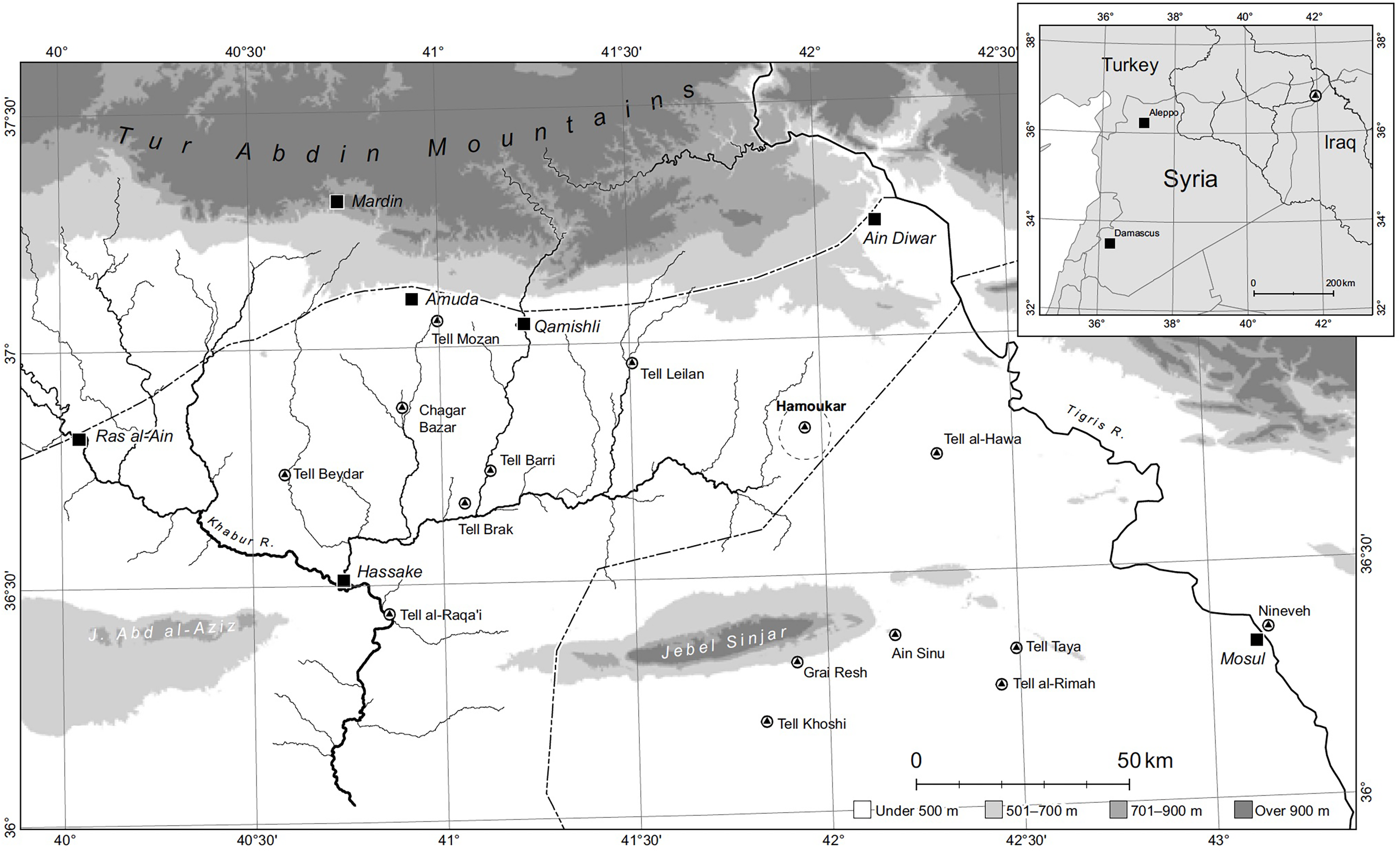
Major urban centers of the third millennium B.C. in northern Mesopotamia (map from Ur 2010a Fig. 1.1)

Excavations at the site of Hamoukar in northeastern Syria from 2008 to 2010 were designed to tease apart different phases in the life of the third millennium B.C. city and to offer new insights into the site’s development – insights that could shed light on the diversity of urbanisation processes at play in northern Mesopotamia. This article presents the results of excavations in the lower town at Hamoukar, focusing on the stratigraphy of the site’s development over the course of the second half of the third millennium B.C. Prior to the excavations in 2008, Early Bronze Age Hamoukar was known primarily from survey and from excavations targeting the final phase of its third millennium B.C. occupation, when the site was violently destroyed. There is, however, much to be gained by focusing not just on this final phase in the city’s life but also on the sequence of transformations that preceded it over a few short centuries. The stratigraphy of urban development at Hamoukar, as revealed in excavations in the lower town, has much to contribute to the new wave of multi-linear, historically contingent, and non-deterministic models for the urbanisation process.
Hamoukar
The site of Hamoukar (ancient name unknown) is located on the eastern edge of the upper Khabur basin in the northeastern corner of modern Syria. During the later part of the third millennium B.C., Hamoukar was one of the largest settlements in northern Mesopotamia. The high mound and the lower town, both occupied during this period, cover a combined area of approximately 98 hectares. In 1999, 2000, and 2001, survey and excavation on the high mound and in the lower town revealed extensive evidence for an occupational phase with a distinctive ceramic assemblage, assigned by the excavators to the Akkadian/post-AkkadianFootnote 2 period (Gibson et al. Reference Gibson, al-Azm, Reichel, Quntar, Franke, Khalidi, Hritz, Altaweel, Coyle, Colantoni, Tenney, Abdul-Aziz and Hartnell2002b: 23). This phase ended in a violent episode of destruction and was followed by a long period of abandonment. The site was not reoccupied until the first millennium B.C.
Given this evidence for destruction and abandonment, it is hardly surprising that Hamoukar has played a role in debates about the collapse of settlement in northern Mesopotamia during the later third millennium B.C. In particular, if the final phase of third millennium occupation at Hamoukar can be dated to the post-Akkadian period, as argued by Ur (Reference Ur, Laneri, Pfälzner and Valentini2012), then Hamoukar would be one of the few major settlements in the region that survived into the post-Akkadian period, that is, one of the few settlements that survived the episode of collapse and settlement abandonment that swept across the region during the later part of the third millennium B.C. Indeed, far from merely surviving, Hamoukar appears to have been a massive, flourishing, urban settlement at the time of its destruction (Colantoni and Ur Reference Colantoni and Ur2011). However, as noted by Grossman (Reference Grossman2013) and Reichel et al. (Reference Reichel, Paulette, Grossman and Weiss2012), the dating of the destruction of Hamoukar’s lower town to the post-Akkadian period is far from certain.
Hamoukar was well known, was visited frequently by archaeologists, and was surveyed many times during the 20th century (e.g., Meijer Reference Meijer1986; Van Liere Reference Van Liere1963; Van Liere and Lauffray Reference Van Liere and Lauffrey1954). However, the first and to date only excavations at the site were a collaboration between the Institute for the Study of Ancient CulturesFootnote 3 of the University of Chicago (ISAC) and the Syrian Directorate General of Antiquities and Museums (DGAM), with the University of Toronto and the Royal Ontario Museum (ROM) joining as partners in 2010. There were two distinct periods of work at Hamoukar, what I refer to in this paper as the first campaign (1999–2001) and the second campaign (2005–2010). During the first campaign, work at the site began in 1999 under the direction of McGuire Gibson (ISAC) and Mohammed Maktash (DGAM) and continued in 2000 and 2001 under the direction of McGuire Gibson (ISAC) and Amr al-Azm (DGAM). Following a four-year hiatus, work then resumed as a second campaign in 2005 under the direction of Clemens Reichel (ISAC, Univ. of Toronto, ROM) and Salam Al Kuntar (DGAM, Univ. of Cambridge). This second campaign included four seasons of excavation (2005, 2006, 2008, 2010) and one study season, during which a geophysical survey was also conducted (2007). Work at the site stopped with the onset of the Syrian civil war in 2011. The research on which this article is based took place within the second campaign, during the 2008 and 2010 excavation seasons.
The basic occupational sequence at Hamoukar was established during the 1999–2001 seasons through a combination of controlled surface collection and the excavation of a step trench on the high mound (Gibson et al. Reference Gibson, Maktash, Franke, Al-Azm, Sanders, Wilkinson, Reichel, Ur, Sanders, Salameh, Hritz, Watkins and Kattab2002; Ur Reference Ur2010a). The periods represented at the site include Halaf, Ubaid, Late Chalcolithic, Ninevite 5, Akkadian/post-Akkadian, Neo-Assyrian/post-Assyrian, Seleucid, and Early Islamic (Gibson et al. Reference Gibson, al-Azm, Reichel, Quntar, Franke, Khalidi, Hritz, Altaweel, Coyle, Colantoni, Tenney, Abdul-Aziz and Hartnell2002b). A series of soundings excavated by the author in 2008 in the lower town further clarified the third-millennium B.C. portion of this occupational sequence.Footnote 4
The excavations and surveys conducted during the 1999, 2000, and 2001 seasons have been published elsewhere (Gibson and al-Azm Reference Gibson and al-Azm2003; Gibson and Maktash Reference Gibson and Maktash2000; Gibson et al. Reference Gibson, Maktash, Franke, Al-Azm, Sanders, Wilkinson, Reichel, Ur, Sanders, Salameh, Hritz, Watkins and Kattab2002a; Wilkinson Reference Wilkinson2002; Ur Reference Ur2002a-c, Reference Ur2004, Reference Ur2010a), and there is no need to provide a detailed overview here. I would, however, like to focus briefly on the evidence for occupation during the third millennium B.C. uncovered in these early seasons, as this material is directly relevant to the research goals of this report. In fact, the work conducted in third-millennium B.C. levels during 2008–2010 was a direct outgrowth of the results of the 1999–2001 seasons; in a number of cases, for example, excavation continued within previously opened trenches.
The Tell Hamoukar Survey, conducted by Jason Ur (Ur Reference Ur2002a, Reference Ur2002b, Reference Ur2004, Reference Ur2010a), provided the broad outlines of third-millennium B.C. occupation at Hamoukar and in the surrounding region. For present purposes, three of Ur’s findings are particularly important. First, the high mound and the lower town were covered by a relatively continuous scatter of sherds dating to the mid-late third millennium B.C., suggesting that the entire mounded portion of the site had been occupied during this period. Second, there was no evidence for occupation on the high mound or in the lower town during the second millennium B.C. Third, Ninevite 5 pottery was found “bleeding out” of the edges of the high mound. Although Ur offered several possible explanations, he considered it most likely that the Ninevite 5 material also extended across much of the lower town but was masked in the survey by the overlying mid-late third millennium B.C. remains. These three findings provided a basic outline for the sequence of third-millennium B.C. occupation at Hamoukar. The site grew to between 90 and 100 ha during the late Ninevite 5 period. This urban-scale occupation at Hamoukar continued until the Akkadian period or soon after. There was then no further occupation at the site until the Neo-Assyrian period.
Previous excavations at Hamoukar have also produced substantial evidence for occupation at the site during the third millennium B.C. On the high mound, excavation of a step trench during the first campaign (1999–2001) in Area A (Fig. 2) revealed a phase of occupation dating to the Ninevite 5 period, evidenced by a sherd layer (although unfortunately with no associated architectural remains). The step trench also uncovered later walls built on top of this sherd layer, associated with material dating to the mid-late third millennium B.C. (Gibson et al. Reference Gibson, al-Azm, Reichel, Quntar, Franke, Khalidi, Hritz, Altaweel, Coyle, Colantoni, Tenney, Abdul-Aziz and Hartnell2002b: 12–15). During the second campaign (in 2005), Tate Paulette supervised excavation of portions of a monumental building in Area A that was dated by ceramics to the late Ninevite 5 period.
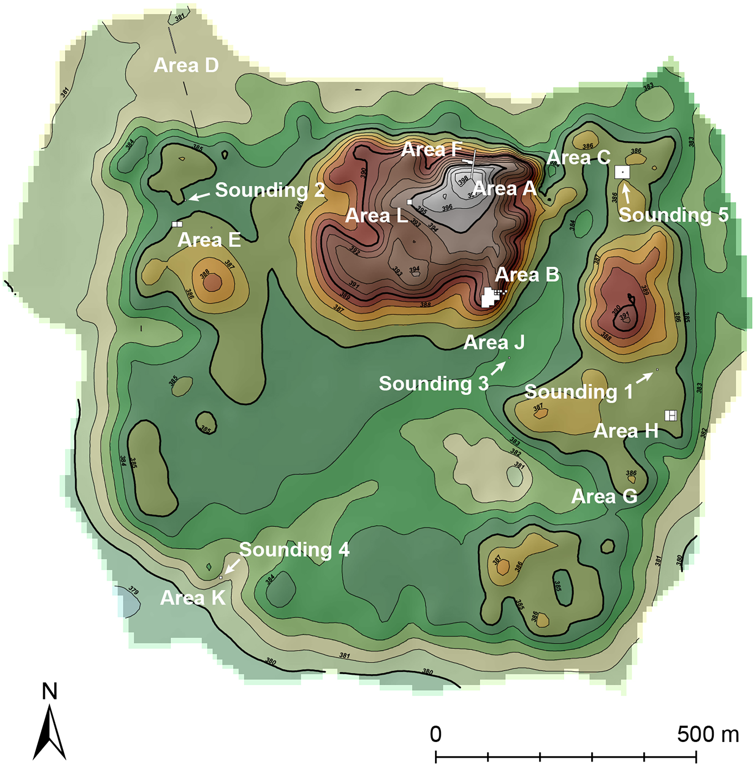
Topographic map of Hamoukar showing excavation areas. Base map courtesy of Jason Ur

In the lower town, three different excavation areas produced evidence for occupation during the final phase of the site’s occupation in the third millennium B.C. Excavations in Area C, in the northeast corner of the lower town, began during the first campaign and continued under the supervision of Tate Paulette during the second campaign. These excavations uncovered portions of two buildings separated by a broad street. The finds included a rich in situ ceramic assemblage, zooarchaeological and lithic material, bureaucratic tools, figurines, and evidence of architectural rebuilding and repairs. The two buildings both resembled houses, architecturally, but contained intriguing evidence for cult activities: a baked brick altar and niched doorway in Building B (see Reichel et al. Reference Reichel, Paulette, Grossman and Weiss2012) and a section of niched wall in Building A (Gibson et al. Reference Gibson, Maktash, Franke, Al-Azm, Sanders, Wilkinson, Reichel, Ur, Sanders, Salameh, Hritz, Watkins and Kattab2002a-b, Reichel et al. Reference Reichel, Paulette, Grossman and Weiss2012). During the first campaign, excavations in Areas E and H uncovered private houses with in situ ceramic assemblages. In Area H, numerous smashed ceramic vessels and two disarticulated human skeletons, found lying on house floors, suggested that the area had been abandoned following some kind of violent event.
The broad horizontal exposures opened in Areas C, E, and H over the course of the two campaigns recovered a rich and, on the whole, highly uniform ceramic assemblage. In preliminary reports, excavators referred to this assemblage as either “Akkadian/early post-Akkadian” or “Akkadian/post-Akkadian” (Gibson et al. Reference Gibson, al-Azm, Reichel, Quntar, Franke, Khalidi, Hritz, Altaweel, Coyle, Colantoni, Tenney, Abdul-Aziz and Hartnell2002b: 23–27; Ur Reference Ur2002a: 70–71). Colantoni and Ur (Reference Colantoni and Ur2011) have provided a more detailed argument for dating this level to the late Akkadian or early post-Akkadian period. The argument hinges on a type of comb-incised decoration that appears in post-Akkadian levels at Tell Brak and a number of other sites (these are best illustrated in Rova Reference Rova and Lebeau2011 by types 103, 105, 113). This decoration is common at Hamoukar, where it typically appears on a distinctive form of urn, which often includes feet (e.g., Colantoni and Ur Reference Colantoni and Ur2011: 106–110, 254–256).
Numerous radiocarbon samples were recovered during the 2006, 2008, and 2010 excavation seasons, but these samples have not been analyzed. A single radiocarbon sample from the 2001 excavations in Area C yielded a date of 2470–2210 cal. B.C. (Gibson et al. Reference Gibson, al-Azm, Reichel, Quntar, Franke, Khalidi, Hritz, Altaweel, Coyle, Colantoni, Tenney, Abdul-Aziz and Hartnell2002b: 32–34), which unfortunately does not offer definitive evidence for placing the Area C remains within either the Akkadian or post-Akkadian period. This means that we must rely primarily on stratigraphic, ceramic, and glyptic evidence as relative chronological indicators. As I show below, the stratigraphic sequence excavated in the lower town in 2008 and 2010 raises some questions about placing the date of Hamoukar’s final occupation in the late Akkadian or early post-Akkadian period.
The material presented here was excavated as part of the author’s dissertation project (Grossman Reference Grossman2013). One component of this project was to develop a new typology for third millennium B.C. ceramics at Hamoukar, based on material recovered from stratigraphic excavations (as opposed to surface collection). The typology was created following the 2010 season, but given the cessation of work after 2010, we were unable to use the newly created typology to quantify the ceramic assemblage and provide rates of change in relative abundance of ceramic types. The ceramic data presented here are therefore based on the presence/absence of particular types in any given context, rather than a quantification that would allow us to judge diachronic change in the relative abundance of particular types.
In the sections below, I outline the results of excavations in 2008 and 2010 that shed new light on the stratigraphy of Hamoukar’s lower town. This is followed by discussion of the implications for our understanding of the urbanisation process at the site and how the site compares with other contemporary urban settlements across northern Mesopotamia.
Soundings in the lower town
In 2008, a new project was begun under the auspices of the larger Hamoukar project, aimed specifically at understanding the earlier periods of third millennium B.C. occupation at the site and the urbanisation process (Grossman Reference Grossman2013). Excavation of a series of small soundings across the site’s lower town in 2008 (Fig. 2: Soundings 1–5) confirmed the broad patterns identified during surface survey and established the basic sequence of occupation in the lower town during the third millennium B.C.
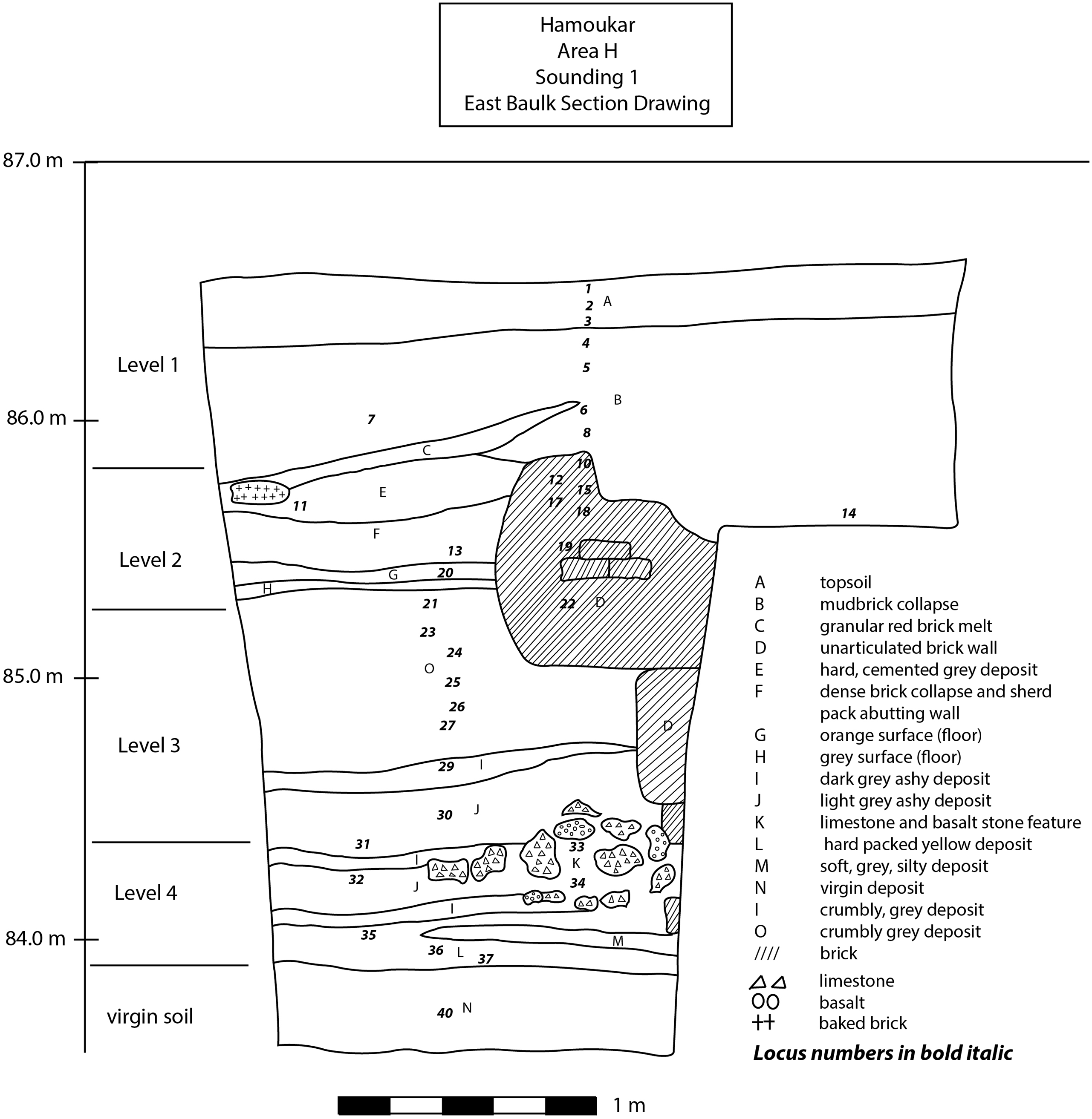
Sounding 1, Area H
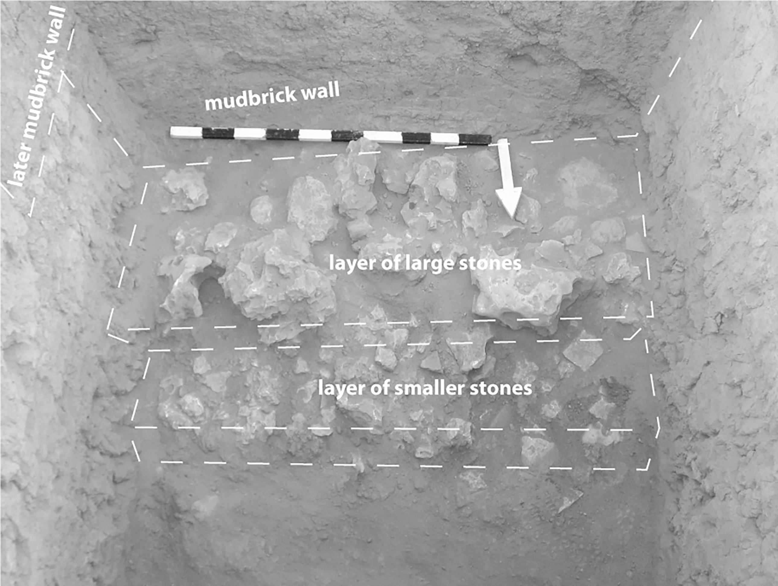
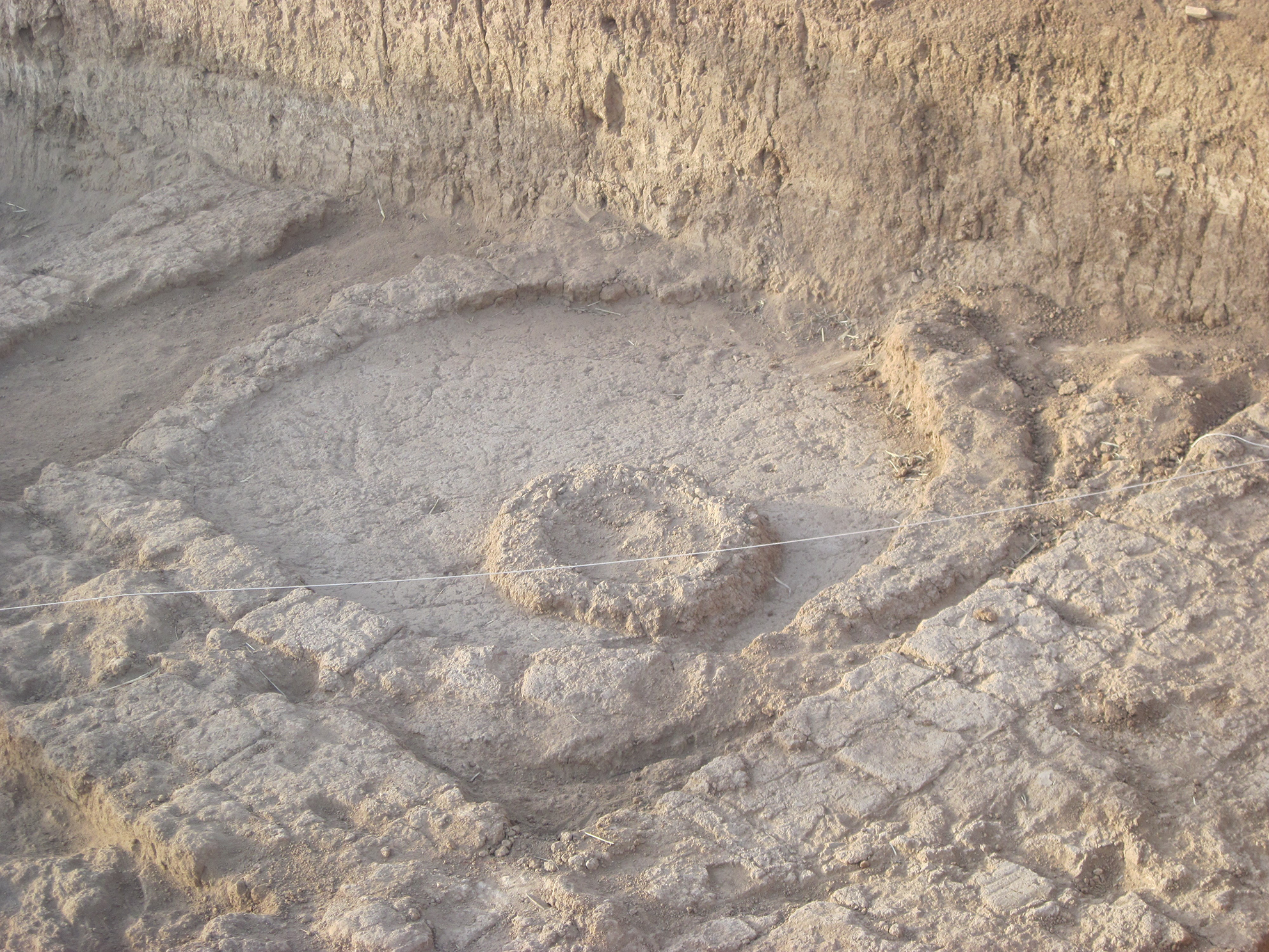
The stratified archaeological deposits in Sounding 1 (Fig. 3) provide one of the clearest sequences of occupation in Hamoukar’s lower town and the strongest excavated evidence for the initial settlement of the lower town during the Ninevite 5 period. The sounding was begun as a 3x3 m square and was decreased to an area of 2x2 m at a depth of approximately 1.25 m below the tell surface. The sounding was excavated down to virgin soil – a compact, granular, bright red soil devoid of artifacts and features. The first deposits above virgin soil appeared to be wash or debris from a nearby feature or building and consisted of thin layers of stratified ash and soil (L. 35–37 in Fig. 3). There were limited finds from this phase; the pottery was mostly undecorated fine wares. In the next level above, an unusual wall was built on top of the ash and soil layers. The wall itself was made of mudbrick, but it seems to have been faced with a layer of basalt fragments (worked and unworked) and calcareous stones ranging in size from pebbles to boulders (L. 33–34 in Fig. 3, and Fig. 4). This particular construction form is unusual at Hamoukar. Stone elements do appear within some later third millennium B.C. buildings – door sockets, thresholds, stones incorporated into wall foundations, etc. – but no other major features appear to have been constructed with substantial quantities of stone. Although unusual, stone wall facings in Sounding 1 are not unique at Hamoukar; a similar feature was found in Sounding 4 in Area K (see below).
Area H, Sounding 1, East Section. Elevations are based on arbitrary datum for the site, not m above sea level

Sounding 1, stone wall facing. Photo by K. Grossman

In Level 3 within Sounding 1, a wider mudbrick wall was built on top of the earlier stone-and-mudbrick wall. Within the layers of ash and soil that accumulated against the new wall, the ceramic assemblage was composed primarily of incised/excised Ninevite 5 sherds and undecorated fine wares. Level 3 in this sounding was distinguished by the construction of a much larger mudbrick wall (L. 22 in Fig. 3), built along the same orientation as its predecessors but offset 50 cm to the north – which seems to have been in continual use for some time. There was evidence for a gradual build-up of occupational debris up against this wall (L. 21, 23–24 in Fig. 3), including ceramics that were mostly undecorated Ninevite 5 types (carinated footed bowls, beaded rim bowls with pointed bases, etc.). In Level 2, this wall was still in use, but a grey and orange mud plaster floor (L.20) was laid against it. A great deal of smashed EJZ 4 pottery was pushed up against the wall, much like the destruction level identified in 2001 in Area H (Colantoni and Ur Reference Colantoni and Ur2011). As elsewhere in the lower town, the uppermost courses of the mudbrick walls in this sounding (Level 1) were subject to intense soil formation processes. Since the area’s abandonment, the archaeological deposits had transformed into a relatively homogeneous soil layer that extended down approximately 50 cm from the tell surface.
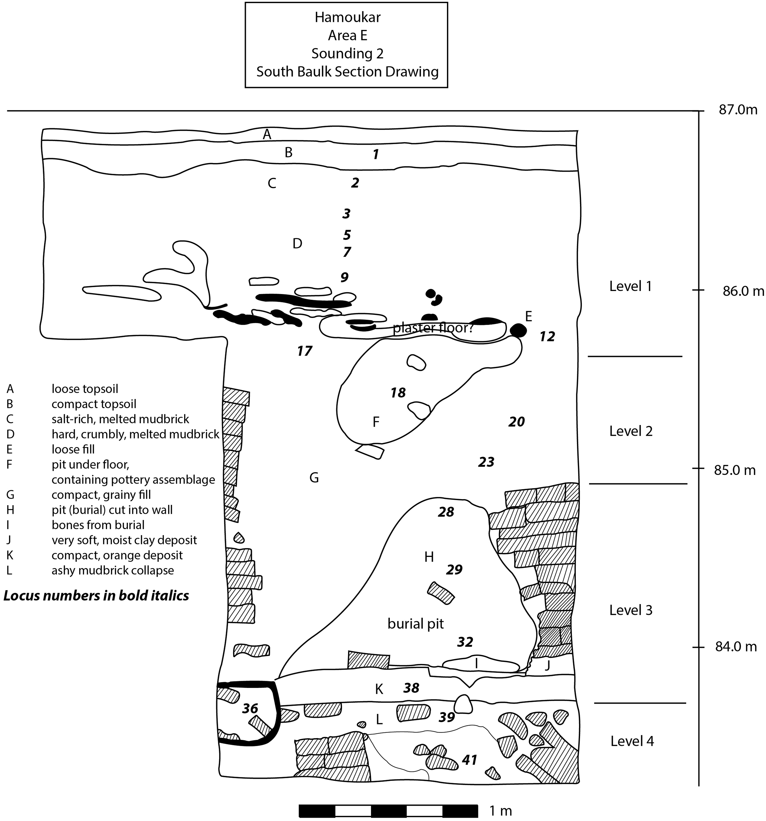
Sounding 2, Area E
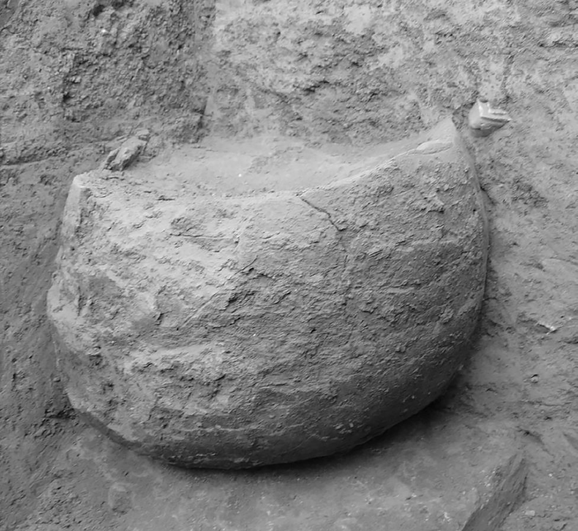
Sounding 2 was begun as a 3x3 m sounding but narrowed to 2x2 m approximately 1 m below the tell surface. Although Sounding 2 did not reach virgin soil, it did produce evidence for continuous occupation from the EJZ 2 through EJZ 4 periods (Fig. 5). The lowest level reached in Sounding 2 (Level 4, nearly 3 m below the tell surface) revealed two mudbrick walls, running northeast-southwest and northwest-southeast, that joined to form the corner of a room filled with ashy soil. The ceramics recovered from the ashy room fill were incised/excised Ninevite 5 sherds. During the succeeding level, the architecture was leveled off, and a thick floor of orange clay was laid down (L. 38 in Fig. 5). A bowl made of unbaked but sun-hardened clay (L. 36 in Fig. 5, Fig. 6) was set into this floor in the southeast corner of the sounding. Two mudbrick walls were built on this floor, oriented in the same northeast-southwest and northwest-southeast direction as the earlier phase. One of the walls was built directly on top of the unbaked clay vessel. These two walls were preserved to a height of nearly 1 m. The room formed by these two walls was disturbed by a pit grave cut from a higher level (L. 28, 29, 32 in Fig. 5). A rather ephemeral phase of occupation followed. In Level 2, the wall in the western part of the sounding was leveled off, while the wall in the eastern part continued in use. No identifiable floors were associated with this level. It does seem likely, however, that the pit grave was cut from this level (that is, the bottom of Level 2). The top of the burial pit was identified at roughly the same elevation as the top of the western wall. This bell-shaped pit contained the remains of two individuals and their associated grave goods: several whole miniature vessels, a large storage jar, and a bracelet of pierced shells. Although the osteological remains were poorly preserved, one adult individual appeared to have been buried in a flexed position. The second body was too poorly preserved to determine the burial position or age at death. The presence of small Stone Ware jars in the grave assemblage points to a mid-third millennium B.C. (or very late Ninevite 5) date (Pruß Reference Pruß, Marro and Hauptmann2000). In the uppermost level within this sounding (Level 1), new mudbrick walls (almost completely destroyed by soil formation) were built on the architectural remains from Level 2. A pavement of baked bricks was set into a mud plaster floor in the northeast corner of the sounding. This pavement was covered in ashy soil and the remains of smashed vessels dating to the EJZ 4 period.
Area E, Sounding 2, South Section. Elevations are based on arbitrary datum for the site, not m above sea level

Unbaked clay bowl, Sounding 2. Photo by K. Grossman

Sounding 3, Area J
Sounding 3 was located in a depression near the northern portion of the center of the lower town. We placed this sounding in a deep modern cut (trash pit), hoping to reach deep intact archaeological deposits more quickly than in other areas. Unfortunately, this sounding was not particularly productive; we excavated to a depth of 2.5 m in arbitrary levels. At the surface, we began the unit as a 3x3 m square and reduced the size to a 2x2 m square approximately 1.25 m below the surface. The deposits within this sounding, from the surface to the lowest point of excavation, were composed of thin layers of slope wash and fine lenses of water-levigated soils, with no traces of architecture, pits, or other features. If there are intact archaeological deposits that would indicate occupation in this area, they are deeply buried by millennia of slope wash from the high mound. Unsurprisingly, ceramics from this sounding were mixed; third and fourth millennium B.C. forms occurred together throughout the entire 2.5 m depth of excavation, along with occasional clay ovoids (“sling bullets”) and other materials commonly found in the fourth millennium B.C. levels on the high mound in Area B (see Gibson et al. Reference Gibson, al-Azm, Reichel, Quntar, Franke, Khalidi, Hritz, Altaweel, Coyle, Colantoni, Tenney, Abdul-Aziz and Hartnell2002b).
These finds, as well as the levigated soils and homogeneous stratigraphy, support the idea that this area was composed largely of slope wash from the south face of the high mound. The sounding was informative about tell formation processes at Hamoukar, but it was not very useful for understanding the third millennium B.C. occupation of the site. Despite the survey results, which had shown abundant Ninevite 5 sherds on the tell surface in this area, not a single clearly identifiable Ninevite 5 sherd was recovered in the course of excavating the sounding. This probably means that the Ninevite 5 ceramics recovered during survey had washed down from the high mound, where they are also prevalent. This was the only area within the lower town in which stratified occupation levels were not found directly below the tell surface, and it was the only one of the five soundings in which excavation did not directly corroborate Ur’s survey results.
Sounding 4, Area K
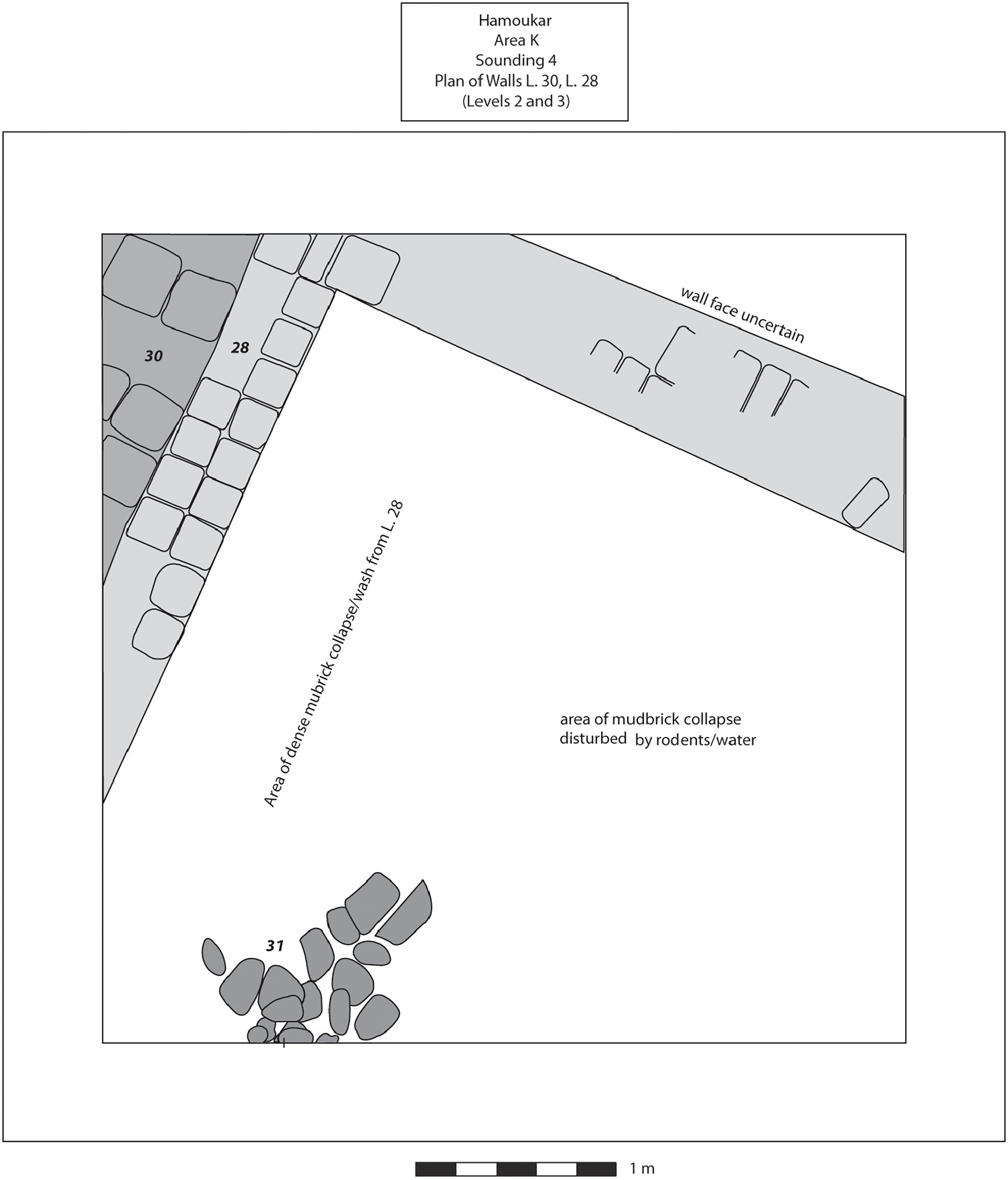
Sounding 4 was located near the southwest corner of the lower town, the first excavation in this portion of Hamoukar’s lower town. Ur’s survey had shown a high concentration of Ninevite 5 sherds in this area. We observed the same concentration again in an informal survey of the area during 2007: a scatter of incised/excised fine wares, pedestal bases, and pointed fine ware bases, bleeding out of the side of a shallow gulley. Because of this sherd concentration and the low elevation, we expected Ninevite 5 levels to be closer to the surface in this area than they had been in Soundings 1 and 2. Expecting this shallower depth of archaeological deposits and hoping to expose a larger area of Ninevite 5 occupation, we laid out this unit as a 5x5 m square.
Like Sounding 1, Sounding 4 was excavated to virgin soil. Unfortunately, much of the trench was disturbed, but we managed to delineate a few architectural features in a single level below the topsoil (Fig. 7). The architecture in Sounding 4 comprised a reddish-brown mudbrick wall built on virgin soil and running across the northwest corner of the trench. A packed earth floor covered in a thick layer of ash was built up against the wall. The wall was later reinforced with pinkish-white bricks added to its eastern face, and a perpendicular wall – badly disturbed by rodent holes – was built, forming the corner of a room. The room was filled with fine, windblown soils and was heavily disturbed by rodent holes. The remnants of a contemporary stone feature comprising a collection of unworked calcareous stones and both worked and unworked basalt pieces was uncovered in the southwestern corner of the trench. A dense deposit of sherds had built up against both sides of this feature, most likely left behind by processes of soil deflation and erosion. It was this deposit, eroding out of the side of a small gully, that seems to have produced the dense cluster of Ninevite 5 sherds observed on the surface during the 1999 site survey (Ur Reference Ur2010a). The upper deposits in Sounding 4 were heavily disturbed by a deep plough zone which contained a mix of ceramics from the Late Chalcolithic, EJZ 2 through EJZ 4, and Islamic periods.
Sounding 4 produced a rich artifactual assemblage, but none of the artifacts came from secure contexts. Prior to excavating Sounding 4, we had hoped that it would be possible to excavate broad horizontal exposures of Ninevite 5 levels in this area. The concentration of Ninevite 5 sherds on the surface suggested that the earliest phase of occupation in the lower town would be easily accessible here. The heavily disturbed deposits that we found, however, argued against expanding our efforts in the southwestern corner of the lower town.
Plan of Sounding 4, Levels 2 and 3

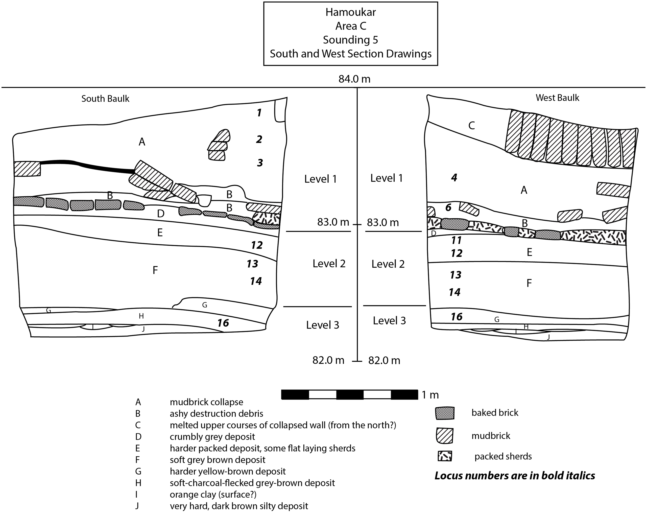
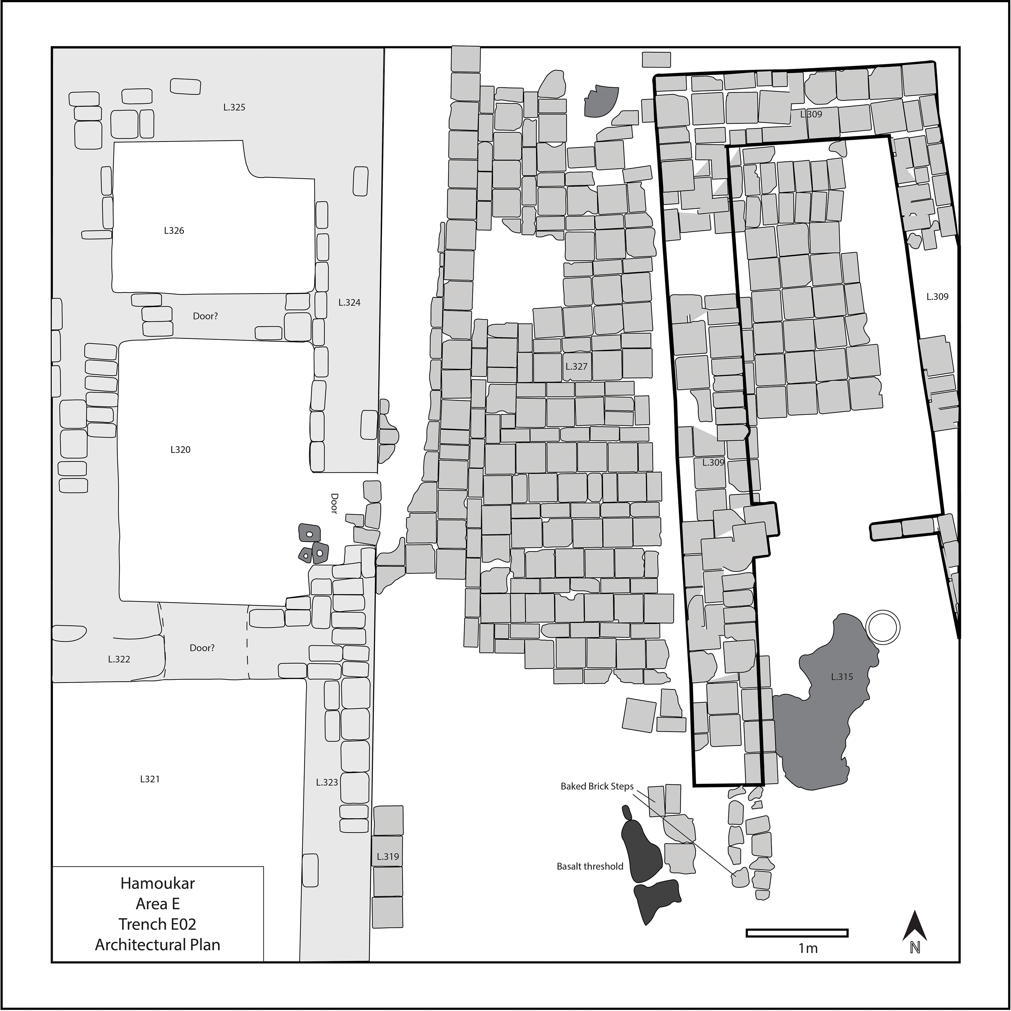
Sounding 5, Area C
The final sounding excavated in 2008 (Fig. 8) was located within an area of ongoing excavations in Area C, in the street between Buildings A and B (see Reichel et al. Reference Reichel, Paulette, Grossman and Weiss2012: fig. 3 for a plan of this area). This was a small sounding, only 1.5x2 m. The lowest level (Level 3 in Fig. 8) excavated in Sounding 5 yielded a series of shallow, compact fill layers with no associated features or architecture, containing Ninevite 5 ceramics. The next level also comprised a series of fill layers with no associated architecture or features, and most ceramic sherds found in this layer were small, abraded, flat lying sherds (Level 2 in Fig. 8). The uppermost level in Sounding 5 was distinguished by the construction, use, and abandonment of the street between Buildings A and B (Level 1 in Fig. 8). The surface of the street sloped up slightly to the northeast. It was paved with baked bricks along the edges of the street and small abraded sherds in the street’s center (Reichel et al. Reference Reichel, Paulette, Grossman and Weiss2012). The street paving was covered by a layer of smashed EJZ 4 pottery, along with thick pockets of ash, collapsed mudbricks, and animal bones. After the abandonment of this area, the walls around the street must have eroded for some time, as there was a good deal of mudbrick wash on top of the smashed sherds that littered the street. The final event of Level 1 was the collapse of the walls surrounding the street. A section of articulated bricks from a fallen wall was clearly visible in the sounding’s west baulk profile. It appears that this section of bricks fell from the southern wall of Building A. Brick collapse and brick melt were sealed by the collapsed wall.
Stratigraphic profile, Sounding 5. Elevations are based on arbitrary datum for the site, not m above sea level

Overview of Results from the Soundings
The five soundings excavated in 2008 provide us with a clearer picture of the stratigraphic history of Hamoukar’s lower town. In particular, the Ninevite 5 period seems to have been the initial period of occupation in the lower town. Four of the five soundings (all except the unproductive Sounding 3) produced evidence of a late Ninevite 5 occupation founded on virgin soil, suggesting that the lower town already encompassed a large area at the time of its founding – all 98 hectares of the site – followed by a period that is ceramically sandwiched between the Ninevite 5 period and the final occupation in EJZ 4. Of these three ceramic periods documented in the lower town, the late Ninevite 5, in particular, seems to have been long-lived, corresponding to multiple architectural levels that, in some soundings, reached a depth of more than two meters. The numerous small finds from the soundings (figurine fragments, tokens, ground stone objects, bone tools, sealings, spindle whorls, metal objects, and small clay objects) also point to differences in the use of space across the lower town, addressed further below.
Excavations in the Lower Town in 2010
In 2010, we reopened excavations in Areas E and H, where the final third millennium B.C. occupation level had already been revealed in 2001. By reopening old excavations, we hoped to more quickly target remains from earlier third millennium B.C. levels. In Area E, excavators in 2001 had opened two 10x10 m trenches laid side by side. The western of the two trenches, E1, yielded the poorly preserved foundations of walls, as well as floors paved with abraded sherds and baked bricks. The eastern of the two trenches, E2, was abandoned rather quickly in 2001 when it produced no architecture or features. In 2010, we reopened excavations across the full extent of these two trenches, labeling them E01 and E02. Sounding 2 was located approximately 30 m north of the Area E trenches.
In Area H, excavators in 2001 had opened six contiguous trenches, four that were 10x10 m and two that were 5x10 m. As in Area E, we decided to reopen the 2001 excavation area in order to proceed more quickly down to earlier levels of occupation. In particular, we reopened the two 10x10 m trenches along the eastern edge of Area H and relabeled these trenches H01 and H02. Sounding 1 was located approximately 80 m north of Area H. The sections below outline the 2010 findings, first from Area E and second from Area H.
Area E: Trench E01
Trench E01 yielded evidence of continuous occupation from the late EJZ 2 through the EJZ 4 period and the most extensive evidence to date of Early Bronze Age mortuary practices at Hamoukar. We were unable to reach virgin soil in this area, but we did reach Ninevite 5 levels – the first of four distinct levels, all third millennium B.C. in date.
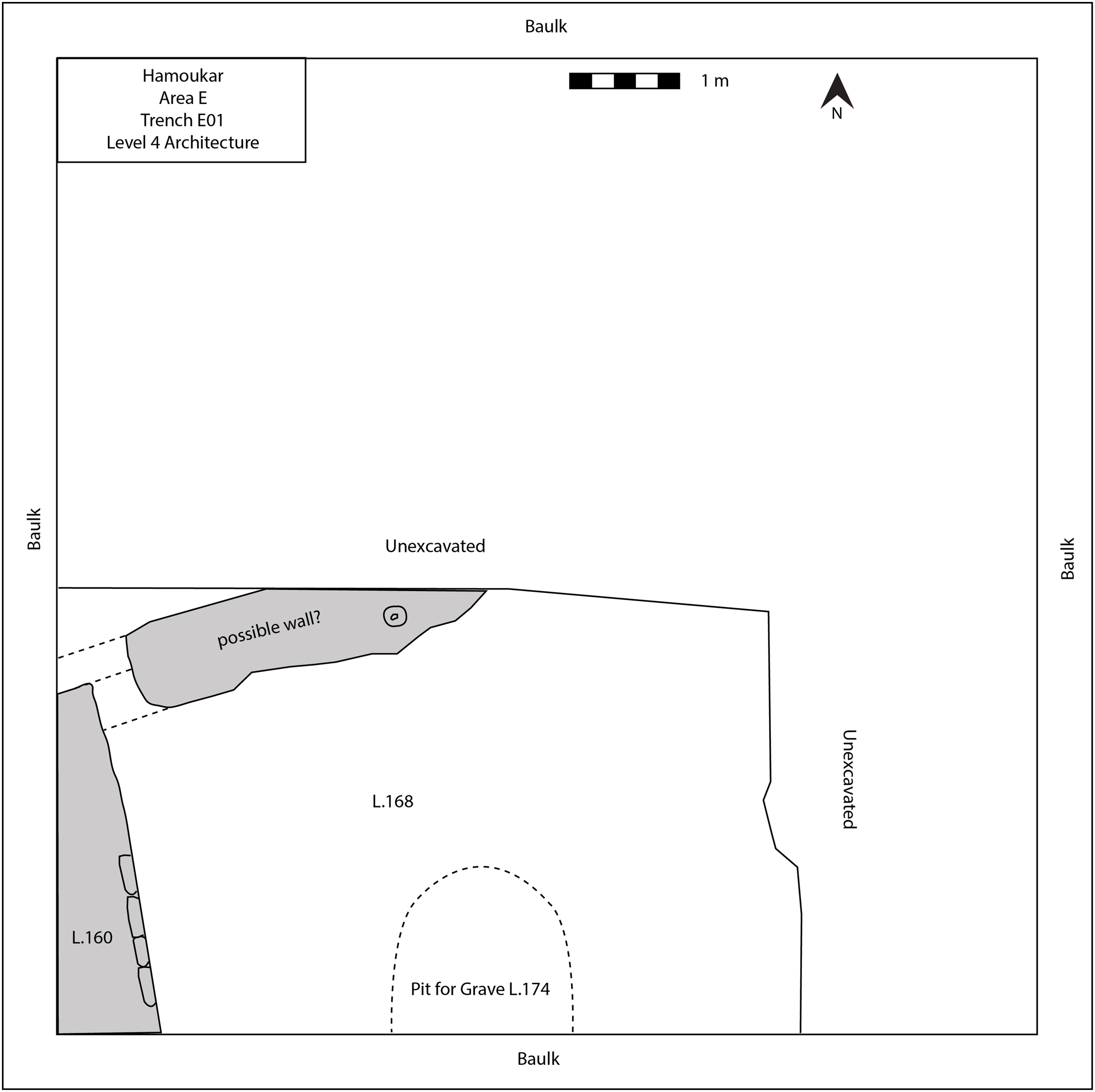
The lowest level uncovered in E01, Level 4, was heavily disturbed by later burials and thus difficult to interpret. The only piece of intact architecture in this lowest level was a wall of hard, orange mudbricks running across the southwest corner of the trench (L.160). This wall was abutted by fine lenses of ash and wash, probably indicating an outdoor courtyard of some kind, as well as another possible wall at a right angle to L.160 (Fig. 9).
Plan of Trench E01, Level 4. Gray indicates mudbrick walls

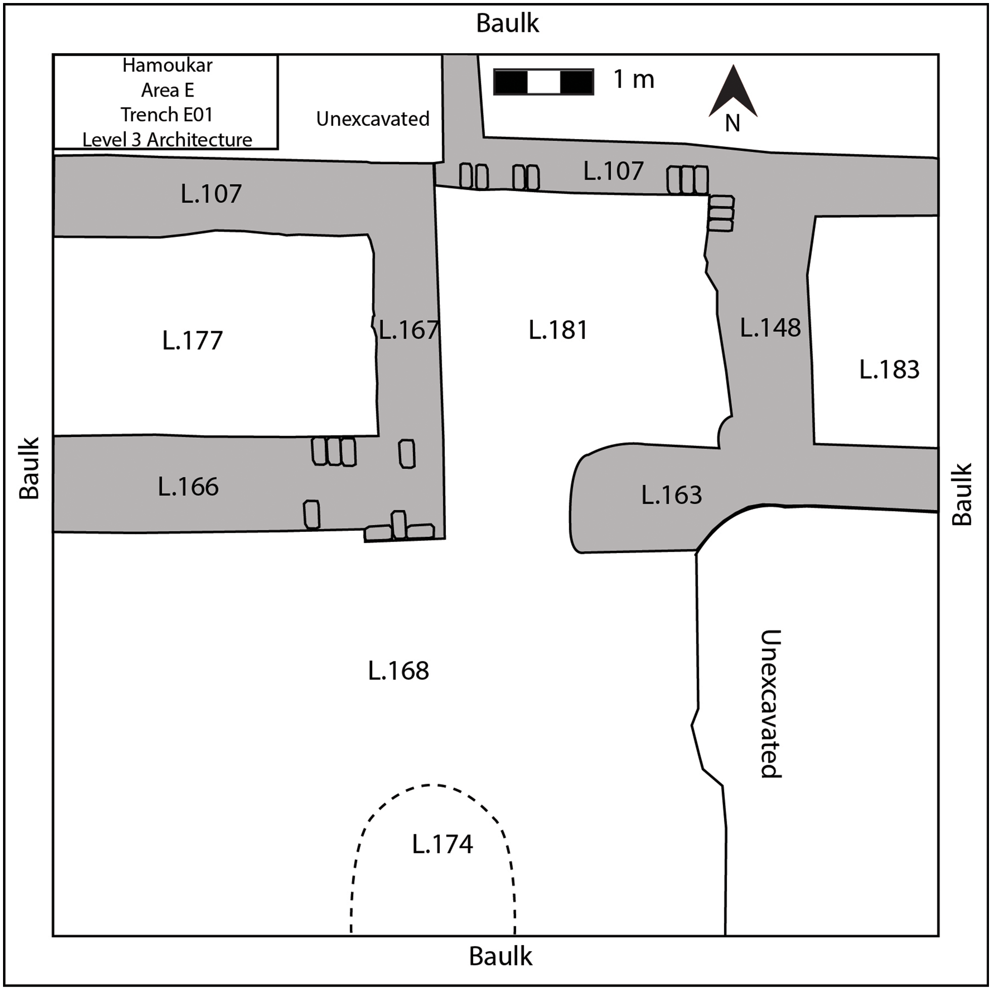
In the next level, Level 3, a series of small rooms with thick mudbrick walls was uncovered in the northern half of the trench (Fig. 10). The rooms were arranged in a row, oriented almost exactly east-west. Although constructed on top of the Level 4 architecture, they exhibited a 30-degree shift in orientation from the earlier level. Where brick lines could be identified, all of the bricks were rectangular. The westernmost of these rooms (L.177) ran into the western baulk and was bounded by walls on the north, south, and east sides. The floor of the room was covered in a thin layer of mud plaster. To the east, a second room (L.181) was again bounded by mudbrick walls. Unfortunately, we were unable to reach floor levels in this room before the end of the season. A third room (L.183) lay directly to the east and ran into the eastern baulk. Again, we were unable to reach a definable floor before the end of the season. The area south of these rooms was badly disturbed by burial pits, but it seems to have been an outdoor space used – as in the previous phase – as a dump for ash and garbage.
Plan of Trench E01, Level 3. Gray indicates mudbrick walls

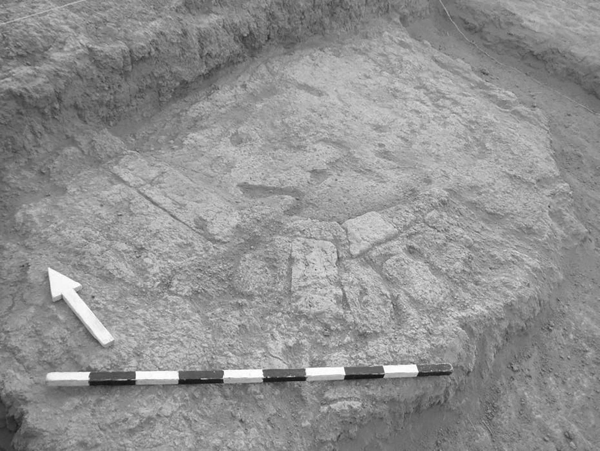
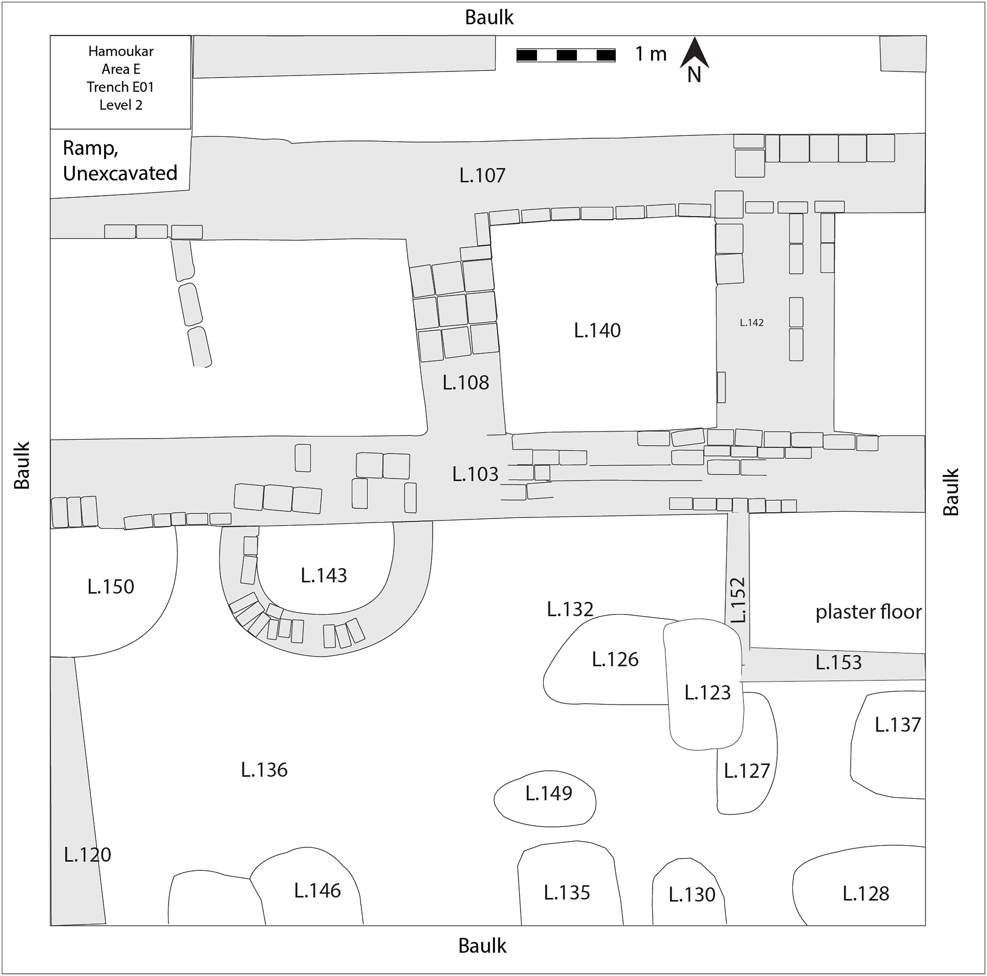
In Level 2, most of the architecture from Level 3 continued in use or served as a foundation for new walls (Fig. 12). However, new construction techniques were used in Level 2, which helped to differentiate the architecture of this level from the preceding one. Unlike the preceding levels, square bricks were more commonly used in the construction of Level 2 buildings. As part of the Level 2 rebuilding, a small fire installation (L.143, Fig. 11, and Fig. 12) was built against the south face of the large wall (L.103) running east-west across the trench. Although only the foundations were preserved, it was clear that it was built in a half- circle shape, approximately 2.5 m in diameter. It was constructed from a combination of baked bricks and mudbricks, with a floor of baked bricks and mud plaster. An ashy fill (L.136) surrounded this feature. As with earlier levels, burial pits cut from above had destroyed much of the architecture from Level 2, particularly in the southern half of the trench.
Fire installation in Trench E02, Level 2. Photo by K. Grossman

Plan of Trench E02, Level 2

The uppermost level in this trench (Level 1) was uncovered by Carlo Colantoni in 2001 and published in his dissertation (Reference Colantoni2004). In the course of removing this upper phase, however, we assigned new locus numbers to the wall foundations and floors that Colantoni had uncovered. Much of the architecture from the earlier Level 2 continued in use, and in the southern portion of the trench, a baked brick pavement built on a dense pack of sherds sealed much of the earlier levels.
Burials in E01
We encountered many burials in the course of excavating E01 (L.174 in Figs. 9 and 10, L.123, 126, 127, 128, 130, 135, 137, 146, 149 in Fig. 11). These pit graves often cut through several levels within the trench and had effectively destroyed much of the stratigraphic sequence in the southern half of the trench. Understanding the stratigraphic relationship between the burials and other features in the rest of the trench was particularly difficult. Many of the burials cross-cut one another, complicating our interpretation of their stratigraphic placement. The burials from Areas E and H are presented in a preliminary fashion in Grossman Reference Grossman2013 and will be published in more detail in a future publication.
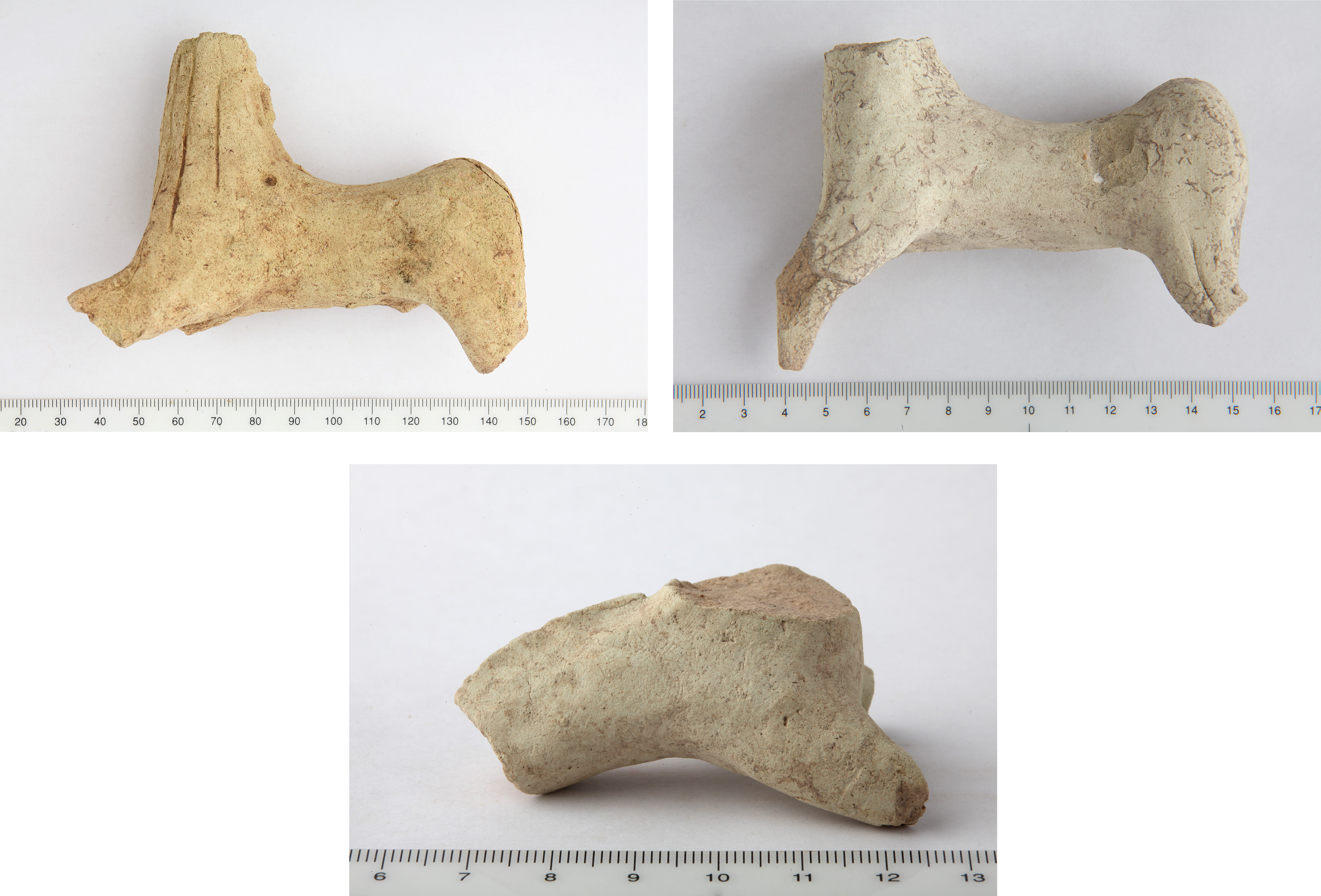
In the southern half of the trench, we encountered large pockets of ash and burnt artifacts, including complete and fragmentary animal (particularly equid) figurines (Fig. 13), clay balls, and beads underneath the baked brick and sherd-paved courtyard of Level 1. The equid figurines in particular have close parallels from Tell Mozan (Hauser Reference Hauser2007), Tell Arbid (Makowski Reference Makowski2015), and Tell Brak (Recht Reference Recht2019). These burnt deposits were the uppermost fill of a series of pit graves and are most likely the remains of some sort of funerary practices. The tops of the graves were sealed below the floors of Level 1; it seems most likely, therefore, that these graves should be associated with Level 2. Most of the burials were undisturbed, with intact skeletons (male and female, adolescent and adult) and assemblages of grave goods. The bodies were all placed in a flexed position, on their backs or sides with knees drawn up and arms crossed. The grave goods varied, but all graves included intact ceramic vessels. One of the most common components of the grave assemblage was a medium-sized jar with a small round-bottomed cup resting in the jar’s mouth. Most graves included this pair of vessels. Beyond that, grave goods included bronze rings and pins, several lead ornaments, a cylinder seal, and a wide variety of ceramic types. One grave contained nearly 50 complete miniature pots.
Equid Figurines from Area E. Photos by B. Oldsen

Area E: Trench E02
Trench E02 was contiguous with E01, located directly to its east. Excavations in E02 were begun in 2001 but were abandoned quickly, as excavators encountered homogenous mudbrick melt, heavily affected by soil formation processes, with occasional pockets of mudbrick collapse and few artifacts. When excavations restarted in this trench in 2010, we continued excavating down through the homogenous matrix for nearly a meter to expose a single level of occupation, in the process revealing a structure unlike any other yet exposed at Hamoukar.
Excavation in E02 revealed a long, rectangular courtyard (or possibly a passageway between buildings, rather than a courtyard) near the center of the trench (Fig. 14). This feature was paved with full- and half-sized baked bricks (28x28x8 cm and 28x14x8 cm) laid in an alternating pattern. Two large, flat ceramic disks, possibly bases for wooden columns, were found in situ on top of these paving bricks and may indicate that the area was roofed, at least partially or temporarily. The baked brick paving seems to have been laid on a foundation of packed sherds; we did not excavate below the paving but saw hints of the foundation material in places where the bricks had been removed in antiquity. A scatter of smashed EJZ pottery covered the paving, including examples of comb-incised ware that is one of the hallmarks of the late EJZ 4b and EJZ 4c (Rova Reference Rova and Lebeau2011: types 103, 105, 113). Some disturbed human remains – a skull and a tibia – were also found in the fill layers immediately above the paved courtyard. In 2001, similar, disarticulated human remains were found scattered on the pavements and floors of the destroyed houses in Area H (Colantoni and Ur Reference Colantoni and Ur2011).
Trench E02 architecture. Light gray = mudbrick; medium gray = baked brick; dark gray = the mud plaster floor; and black = basalt

To the east of the paved area, we uncovered the baked-brick foundations of a small, free-standing building (Fig. 14). Only the foundations of this building remained, but these were preserved to a height of four courses in some places. The join between the paving of the courtyard and the building’s foundation was carefully filled in and packed with broken baked bricks and large sherds. The building consisted of a small, rectangular room with a baked-brick floor and an antechamber with a mud plastered floor. A large basalt threshold stone and two low stone steps led through the doorway between the brick-paved exterior space to the west and the antechamber.
Unfortunately, the few finds recovered from the building offered little indication of the building’s function. Some flat-lying sherds were found on the floors of both rooms, but none were reconstructable. The only in situ feature in the building was a ceramic basin set into the plaster floor of the antechamber. This building might have been a neighborhood shrine, with space for ablutions in the outer chamber and ritual space in the inner chamber. There are similar, although much larger, examples of the so-called “temples in antis” from the Ninevite 5 period (see e.g., Matthews Reference Matthews, Gailani Werr, Curtis, Martin, McMahon, Oates and Reade2002), as well as a later third millennium B.C. example from Tell Chuera (Steinbau 6, see Meyer Reference Meyer2014).
To the west of the paved exterior space, excavations exposed the foundations of another building built of mudbricks with a packed-earth floor. We were only able to expose portions of three rooms here and thus cannot speculate much about the layout of the building. While we have little evidence for the function of this building, a doorway in the eastern wall opens directly onto the brick-paved courtyard, associating these rooms with the courtyard and the possible small shrine to the east. The floor of this building appeared to be disturbed in some places, probably indicating intrusive pits, although we were not able to excavate these in 2010.
We halted work in Trench E02 after the discovery of these buildings, as any further excavation would have required removal of this architectural level.
Area H
In 2010, excavations were carried out in Area H in two adjacent squares, H01 (the southern square) and H02 (the northern square). The stratigraphic levels in Area H are continuous across the two trenches; the stratigraphic history of these two trenches in Area H is therefore described together, rather than describing each trench separately.
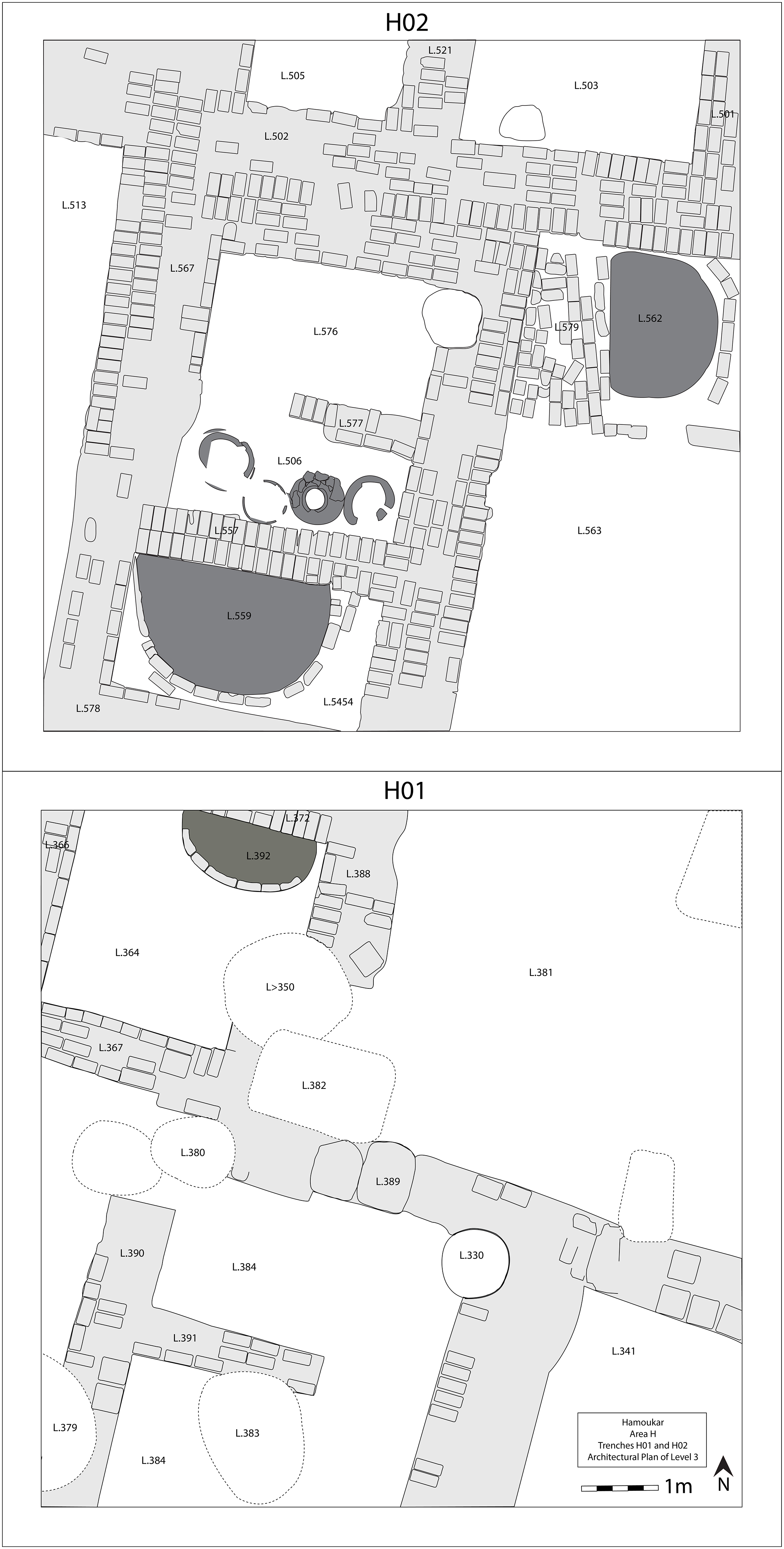
Area H: Level 3
The earliest level reached in Area H during the 2010 season, Level 3, included a series of well-built rooms and fire installations surrounding what appears to have been an open courtyard (Fig. 15). The building was oriented northeast-southwest, and their mudbrick walls ranged from 50 cm to 1 m in thickness. Bricks were regularly laid and generally of a uniform size (28x14x8 cm to 30x12x10 cm). Although only foundations remained and later burial pits cut many of the walls (especially in H01), the preservation of these walls was still excellent. From the coherence of the architecture in this level, it seems likely that most of the walls were built at the same time. Ceramics recovered from this level included incised, excised, and late excised Ninevite 5 sherds, as well as fine undecorated wares with pointed bases and pedestal bases, suggesting an EJZ 2 date.
Plan of Area H, Level 3

This earliest level excavated in Area H is notable for its fire installations. In total we exposed five fire installations belonging to Level 3. Three of these were large, half-circles of mudbrick (just one or two courses preserved) with thick mud plaster floors (L.392, 559, 562 in Fig. 15). The bricks had been partially baked by the heat of fires, and the floors were burnt black. These fire installations in this level almost completely filled the rooms in which they had been set. The lack of space for standing near to and accessing these installations suggests that they were accessed from above and that the walls surrounding the installations were low enough to reach over. The rooms containing these fire installations were arranged around a large courtyard (L. 381, 563 in Fig. 15) that was filled with a deposit of alternating layers of ash and clay. It seems to have been routinely covered with rubbish and ash sweepings, probably from the fire installations; then, from time to time, it was carefully covered with a floor of clay.
In addition to the large fire installations, two tannurs were found in a room near the center of trench H02 (L.506, Fig. 15). These were made of lightly baked and thus poorly preserved clay; we were unable to excavate them fully and had to leave their lower portions encased in the surrounding matrix at the end of the season. The two tannurs were set on either side of two large storage jars that may have held the ingredients that were being cooked in this area. A similar arrangement of large fire installations and smaller tannurs at Tell Arbid has been interpreted as involved in the drying and roasting of grains during the process of beer production (Ławecka Reference Ławecka2008). It is possible that the Hamoukar fire installations served a similar function.
We reached floor levels in every room and every outdoor space in this level but recovered few in situ artifacts. Most portable goods seem to have been removed before the complex was rebuilt in Level 2. The few in situ artifacts found in Level 3 appear to have been rubbish that was left in place when the complex was rebuilt. These included, in particular, several fragments of door sealings found on the floor of the central room (L. 576) in H02. These sealings did not bear seal impressions, but several were incised. One sealing in particular was incised with a five-pointed star; the same five-pointed star motif was found incised on the shoulder of one of the large storage jars as a pre-firing pot mark. Many sherds and smashed jars were recovered from the fill above the floors, rather than from in situ floor deposits. Fragments of jars and strainers were found in the open courtyard. Several sealings were also recovered in the rubbish layers in the courtyard, probably having been removed from jars and doors in the surrounding rooms before being swept out with the trash.
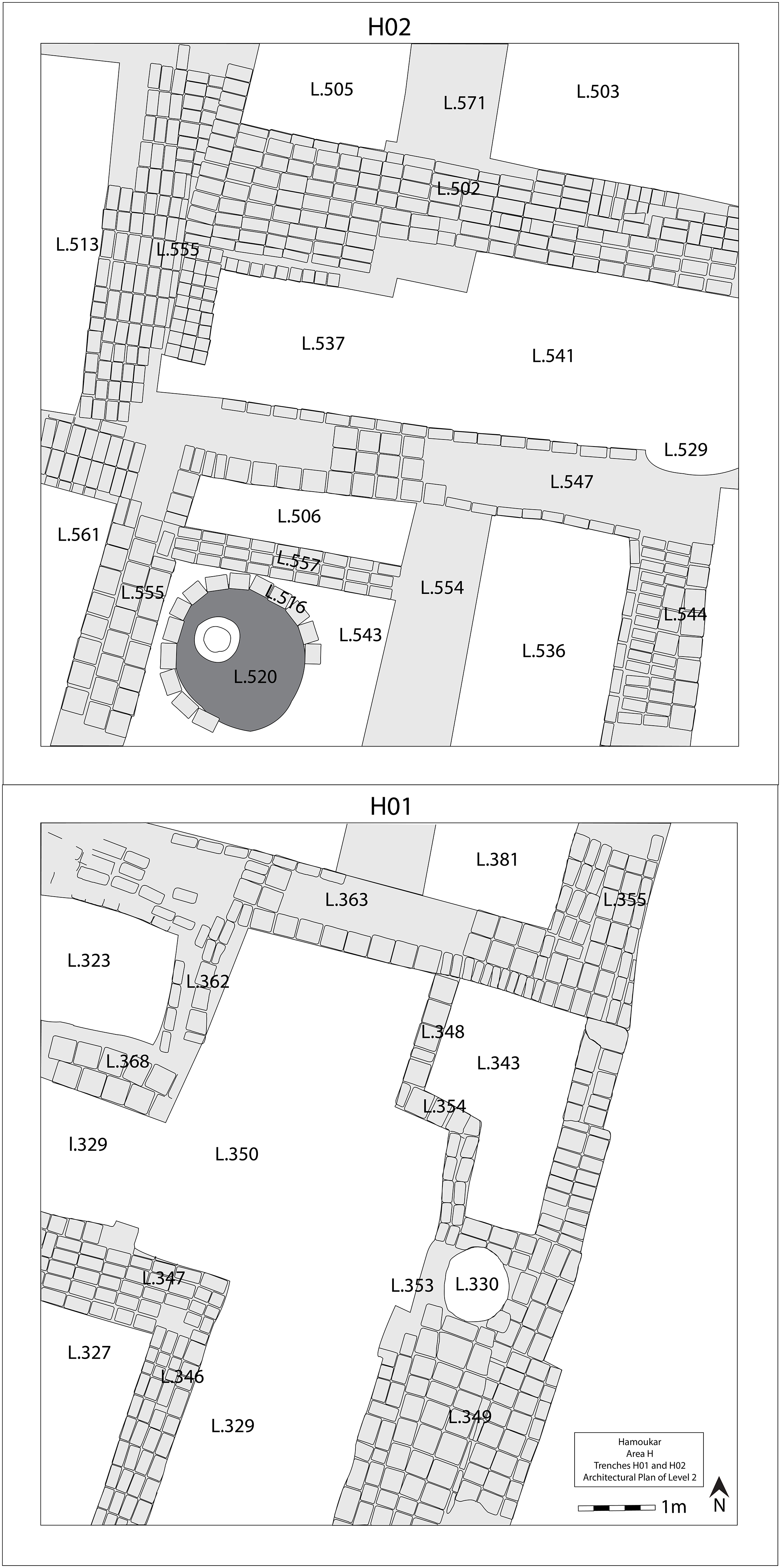
Area H: Level 2
In the second phase of occupation in Area H, the inhabitants reconfigured much of the space but used walls from the earlier level as foundations, without any build-up of deposits on top of these wall foundations (Fig. 16). This suggests that the area did not go out of use between Level 3 and Level 2. A new brick shape did, however, come into use in Level 2; in addition to the rectangular bricks (28x14x8 cm) used in Level 3, square bricks (c. 28x28x10 cm) were introduced in this next level. This mirrors the shift in construction techniques seen in Level 2 of Trench E01. The ceramics recovered from this level showed a marked decrease in decoration, with a few isolated excised Ninevite 5 sherds. Fine ware cups with low carination and both flat and rounded bottoms also occurred in this phase (Fig. 18c, 18k, 18m), and those, coupled with the decrease in decorated wares, point to an EJZ 3 date.
Plan of Area H, Level 2

In Level 2, the long wall on the northwestern side of Trench H02 was rebuilt, using the Level 3 wall as a foundation (L. 555, Fig. 16). The construction of a new wall bisected the room to the west. The fire installation enclosed by walls L. 554, L. 555, and L. 557 was rebuilt as a circular, rather than a half-circular, feature. Like its predecessor, the new fire installation featured a broad, burnt clay floor and brick surrounding wall; however, the Level 2 feature also included a large, sherd-lined depression in the center of the floor, possibly a jar stand (Fig. 20). The wall on the south side of this new fire installation was rebuilt further to the south (L. 363, Fig. 16), covering a fire installation from the earlier level. Perhaps the biggest change in the northern half of the trench, however, was the construction of a wall (L.547) that partially covered the jars and tannurs within the small room in Level 3. A series of at least three superimposed mud plaster floors were laid north of this wall. This series of floors probably functioned as an informal indoor cooking area; each was covered in ash, small burnt areas that might have been open hearths, and small concentrations of smashed vessels.
The transition from Level 3 to Level 2 in H01, the southern trench, is also marked by the construction of a series of walls above the fill in the Level 3 courtyard. These included a large, well-built wall running WNW-ESE (L.363) and a set of thin walls forming an irregularly shaped room (L.343). The space to the west of these small walls seems to have remained outdoor space. However, it was no longer covered in ash layers; instead, layers of fine, hard clay appear to have built up over a period of time. This area was badly disturbed by several large pits cut from above, hindering our interpretation.
As with Level 3, there were relatively few in situ finds from Level 2 (aside from grave goods in the burials, discussed below). A few smashed vessels were found on the mud plaster floors in the center of Trench H02 (L.360), but otherwise finds from this phase came from fill deposits.
Area H: Level 1
As with the transition from Level 3 to Level 2 in Area H, there was a good deal of architectural continuity between Levels 2 and 1. The complex was carefully rebuilt in Level 1. Most walls continued in use or were rebuilt, and new floors were laid in some rooms. Most of the Level 1 architectural remains recovered in 2010 were, in fact, the foundations of walls that had already been uncovered in 2001. The upper parts of these walls had in the meantime been ploughed out; after the backfilling of the trenches in 2001, the area has remained under continuous cultivation. In 2010, we remapped this previously excavated architecture, and, in general, the foundations of the walls lined up with what had been excavated in 2001. Given that this area had already been excavated, few artifacts were recovered from in situ deposits on the floors. Vast quantities of ceramics were, however, recovered from sherd packings that made up the floor foundations. These were dominated by straight-sided cups in fine buff fabrics, a hallmark of the EJZ 4 (Fig. 19f, 19h, 19l).
Although some of the baked brick pavements were removed at the end of the 2001 season, enough remained for us to get a sense of their construction. The baked bricks were often set into a foundation of densely packed EJZ 4 sherds. Colantoni and Ur (Reference Colantoni and Ur2011) have suggested that these pavements may indicate the presence of animal pens, with the sloping, baked-brick surfaces funneling animal waste into sewers and drains.
A large well or silo was also constructed in room 11 of building H I, Level 1, and cut down into earlier levels (see Colantoni and Ur Reference Colantoni and Ur2011, fig. 2 for illustration of location. Building H 1 and room 11 are designations from this earlier publication). The sides of this cylindrical feature were lined in a thick mud plaster (c. 3 cm thick) and pitted at intervals of approximately 50 cm with indentations that appeared to be hand or foot holds (L.330 on Fig. 15, 16). We managed to excavate the fill from this feature to a depth of approximately 3 m but had to stop after it became too deep to lift out the excavator. While several other wells were identified in association with the Level 1 buildings in 2001, the 2010 excavations revealed that these were, in fact, burial pits cut through the baked brick floors.
Area H: Burials
The burials uncovered in Area H derive from two different levels. Many of the graves in H01 appear to have been cut from Level 2. These were all covered by either architecture or other features associated with Level 1, and they all appear to have been placed with reference to the Level 2 architecture (that is, not disturbing the Level 2 walls). The burials cut from Level 2 typically included very well-made stoneware jars. The bodies in these graves, however, were not as well preserved as those found in contemporary burials in Area E; nor were the other grave goods as numerous. In particular, few metal objects or beaded necklaces were found in these graves. As with burials from Area E, the burials from Area H are cursorily presented in Grossman Reference Grossman2013 and will be the subject of a future publication.
Three features cut down from Level 1, the uppermost phase in Area H, into earlier levels were identified as wells by excavators in 2001 (more such features were identified in 2001, but the rest were outside of the 2010 excavated area). The 2010 excavations have shown that some of these need to be reclassified. The feature identified as a well in room 11 of building H I (see above) was indeed revealed to be a well. On the other hand, a feature identified as a well in room 5, building H II (Colantoni and Ur Reference Colantoni and Ur2011: fig. 2) was found in 2010 to be a pit grave with a subadult burial, a child buried with a shallow bowl containing a collection of beads. A second burial, identified as a pit just north of room 12 in 2010, contained an infant interred with small ceramic vessels inside a large storage jar. The haste of these burials, cut through the destruction debris that covered the floors of the buildings in Area H (as identified by the 2001 excavators) and through baked brick pavements, along with the lack of subsequent occupation, suggests a need to quickly bury the dead.
A Stratigraphic Sequence for the Lower Town at Hamoukar
Based on the results of the 2008 soundings and more extensive 2010 excavations, we are now able to identify three distinct phases of occupation spanning the second half of the third millennium B.C. across the lower town at Hamoukar. A broader periodization for the site as a whole is not yet available. The phases presented here, therefore, only describe urban developments in Hamoukar’s lower town in the third millennium B.C. and will need to be worked into the overall periodization of the site at a later date.
Lower Town Phase 1
The earliest phase of occupation in Hamoukar’s Lower Town (Phase 1) dates to the late Ninevite 5 period (EJZ 2). Remains from Phase 1 were uncovered in soundings excavated in Areas E, H and K, as well as in larger exposures in Area E and Area H (Level 3 in trenches H01 and H02, and Level 4 in trench E01). The earliest architectural features of Phase 1 appear to have been built on virgin soil, which was reached within the soundings in Areas H and K.
Phase 1 produced extensive evidence for production processes dependent on fire in Areas E and H. In Area E, thin layers of ash alternating with thin layers of packed earth accumulated within an open courtyard. Unfortunately, the exposure of Phase 1 remains in trench E01 was not large enough to provide further information about the activities that produced this ash. Similar ash layers were identified in the lowest level of the sounding excavated nearby in 2008, suggesting that this ash deposit was extensive. In Area H, a much broader horizontal exposure of Phase 1 remains revealed several large ovens and a series of smaller tannurs surrounding a courtyard covered with alternating layers of ash and packed earth. Area H in this phase appears to have been devoted to large-scale – or supra-household level – food production, probably the production of beer and/or bread.
Ceramically, Phase 1 is characterized by a high percentage of incised/excised and late-excised Ninevite 5 sherds (Fig. 17b, 17d, 17e, 17f, 17k, 17l) and the use of a wide range of fabrics, suggesting an EJZ 2 date for this phase at the site. In fact, decorated ceramics of any type were far more prevalent in the earlier phases than in the later ones. Vessel forms included small cups with pointed bases, shallow pedestal-base cups, and carinated bowls and cups. Fine wares were especially common; the average percentage of fine ware sherds recovered in Phase 1 was far greater than in succeeding occupational phases. This corresponds to observations at sites elsewhere in the Jezirah (see Grossman Reference Grossman and Lebeau2014), especially work on the late Ninevite 5 sequence at Tell Arbid (Smogorzewska Reference Smogorzewska2016). It is also worth mentioning that no painted Ninevite 5 sherds have been recovered from either the survey (Ur Reference Ur2010a: 105) or excavations at Hamoukar, precluding any earlier, EJZ 1, dates for settlement in the lower town.
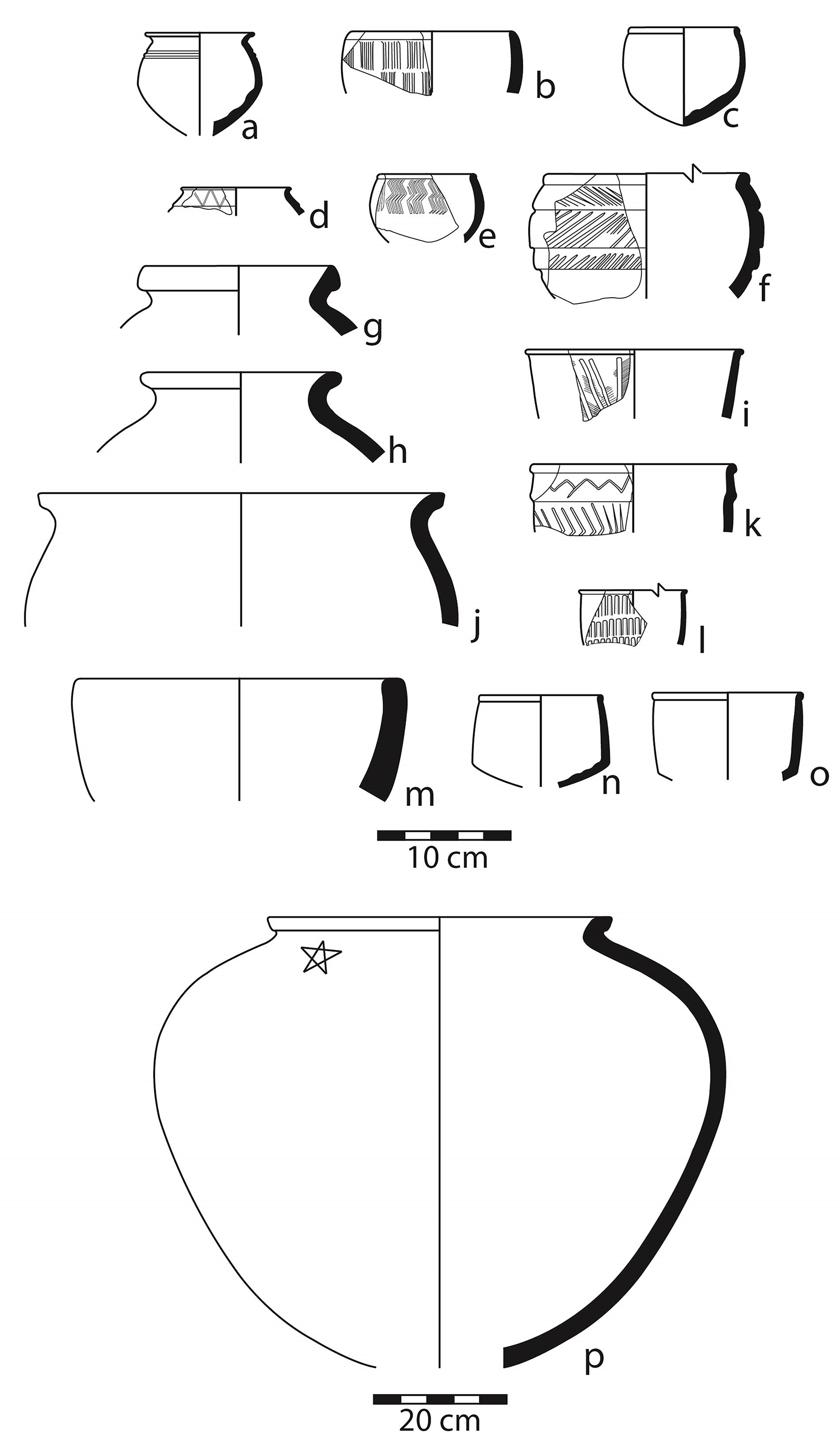
Phase 1 ceramics

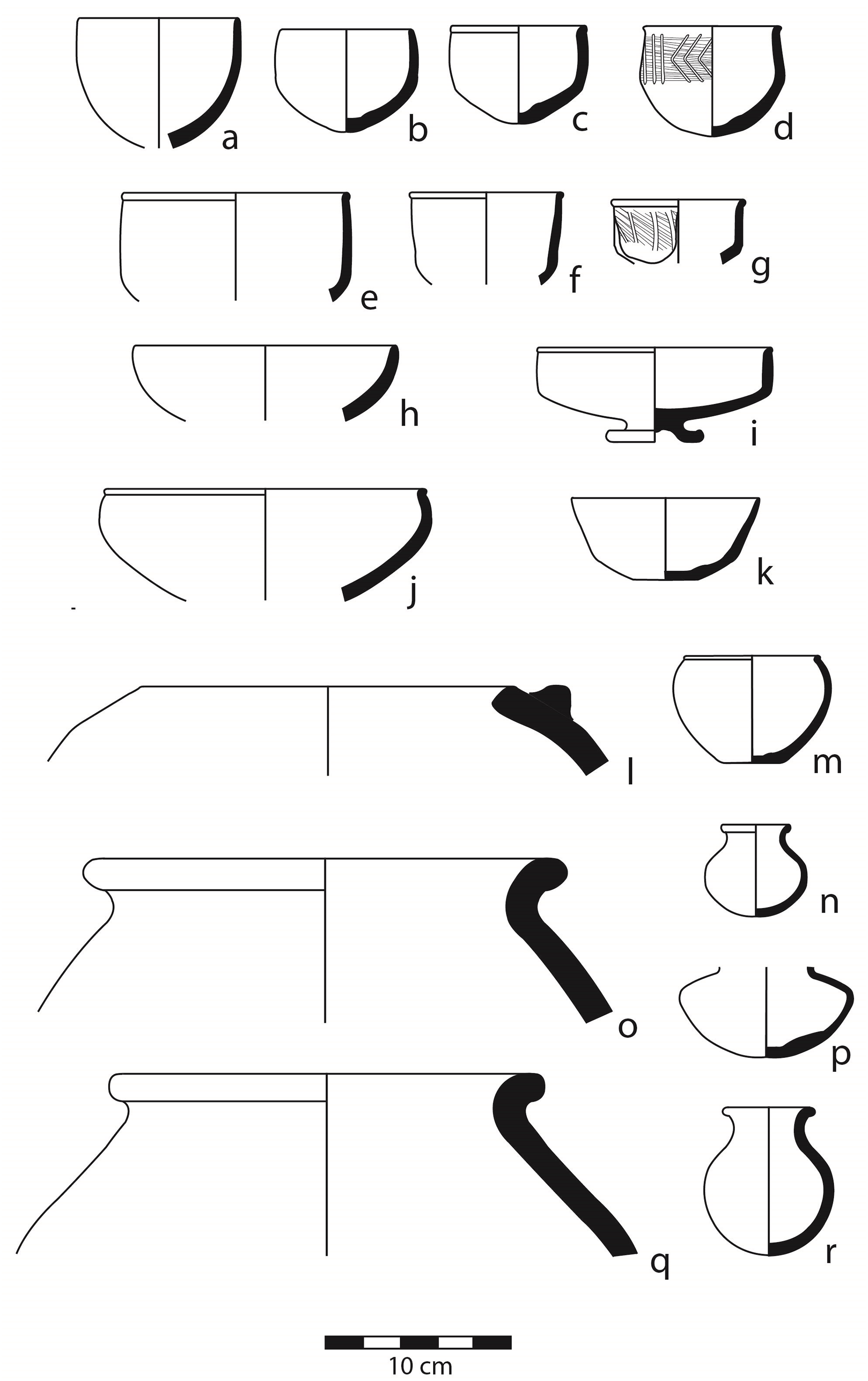
Phase 2 ceramics

Phase 3 ceramics

Trench H01, Level 2 fire installation (L.520), facing southeast. Photo by K. Grossman

Lower Town Phase 2
The second phase of occupation in Hamoukar’s lower town (Phase 2) dates to the post-Ninevite 5 period (EJZ 3). Phase 2 remains were recovered in Areas C, E, and H. In many cases, significant architectural continuity was recognized between Phase 2 and the underlying Phase 1. Many walls either continued in use or were rebuilt in the same position and on the same orientation.
During Phase 2, Areas E and H continued to be devoted primarily to production activities. In Area E, trench E01 was dominated by a building with large, well-built mudbrick walls (levels 3 and 2 in that trench). Attached to this building were the remains of a small fire installation probably used for some kind of craft production. In Area H (level 2 in trenches H01 and H02), on the other hand, production continued to focus on food. In particular, the presence of a very large oven – nearly 2 meters in diameter, with a sherd-lined jar stand set into the oven floor – suggests that food production on a supra-household level continued during Phase 2 in Area H. The end of Phase 2 was marked by the presence of a large number of pit graves in both Areas E and H. These graves were dug down, often a meter or more, into earlier deposits.
Ceramically, Phase 2 was marked by a significant decrease in Ninevite 5 incised-excised decoration relative to Phase 3. Many of the forms present in the earlier phase (pointed bases, pedestal bases, etc.) continued in use, although generally without decoration (Fig. 18c, 18k). One of the most common types in this phase was a small cup with beaded rim and pointed base, although these do appear in the earlier Phase 1 as well. The wide range of ceramic fabrics present in Phase 1 also decreased in Phase 2 as ceramics started to become more standardized. This shift mirrors similar trends at nearby Tell Leilan (Calderone and Weiss Reference Calderone, Weiss, Rova and Weiss2003) and Mohammed Diyab (Rova Reference Rova and Lebeau2011).
Lower Town Phase 3
Remains dating to Phase 3 have been recovered in nearly every trench and sounding excavated across Hamoukar’s lower town and also on the high mound in Area L. Phase 3 includes two well-preserved buildings in Area C, a possible small neighborhood temple in Area E, and a series of domestic complexes in Area H.
Like the transition from Phase 1 to Phase 2, the transition from Phase 2 to Phase 3 was marked by significant architectural continuity, with no clear evidence for a break in occupation. In Areas E and H, where we have the best evidence for this transition, the Phase 2 architecture appears to have been carefully rebuilt in Phase 3. Most walls either continued in use, with new baked brick floors constructed in some rooms, or were rebuilt, using earlier walls as a foundation. Interestingly, Phase 3 is the only phase to make use of baked bricks in construction. This new construction material is found in nearly every Phase 3 context across the site. We have not yet found substantial fire installations from this period that might have been used in creating these bricks; such installations may have been located off-site or in one of the many areas not yet explored at Hamoukar.
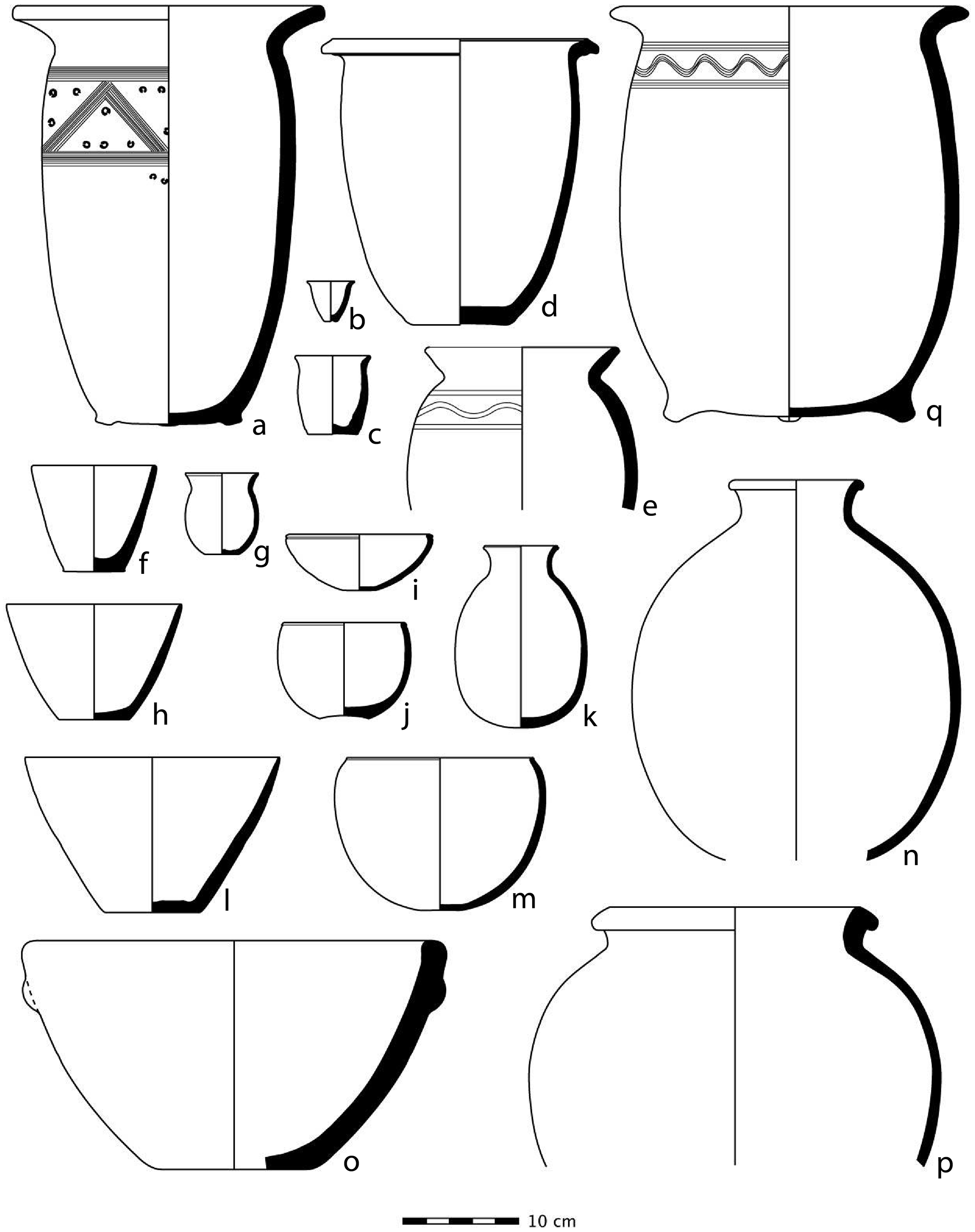
Ceramically, Phase 3 correlates with Period 7 in Ur’s 1999 survey (Ur Reference Ur2010a: 106-109), with broadly standardized forms, especially conical bowls, made from a yellow-green fabric (Fig. 19f, 19h, 19l). In the lower town and on the high mound, the end of this phase was marked by evidence for destruction and abandonment. Destruction contexts with burnt remains, scorched wall faces, and/or smashed vessels were identified across the site. In some cases, human remains were found scattered and scavenged on the floors of the Phase 3 buildings (Colantoni and Ur Reference Colantoni and Ur2011). Following this destruction, some graves were cut from this level into lower ones, but then the site was abandoned and was not reoccupied for over 1500 years.
Implications of the Stratigraphic Sequence in Hamoukar’s Lower Town
The date of the Phase 3 ceramic assemblage has been a matter of some debate, with much attention on whether the ceramic assemblage dates to the Akkadian or post-Akkadian period. Situating Hamoukar’s final phase within either the Akkadian or post-Akkadian period could place the site more firmly within long-standing debates about the extent and nature of Akkadian presence in northern Mesopotamia. Solidifying the dating could also serve as evidence for the site’s collapse as a part of the 4.2 kya climate event or its survival through that proposed catastrophe. Whatever the dating, the extensive burn layers and large numbers of burials cut into earlier levels, as well as the presence of disarticulated human remains found on Phase 3 pavements, suggest a violent end to the city.
The pottery of Phase 3 in Area C was initially published (Gibson et al. Reference Gibson, Maktash, Franke, Al-Azm, Sanders, Wilkinson, Reichel, Ur, Sanders, Salameh, Hritz, Watkins and Kattab2002) as Akkadian or post-Akkadian on the basis of parallels with Tell Brak. Similar pottery excavated in Area H has been published as “late Akkadian or post-Akkadian,” again on the basis of parallels with Tell Brak, as well as Mohammed Diyab and Chagar Bazar (Colantoni and Ur Reference Colantoni and Ur2011; Ur Reference Ur, Laneri, Pfälzner and Valentini2012). The majority of the Phase 3 assemblage is very similar to EJZ 4 assemblages at Tell Brak and Mohammed Diyab, as well as the Tell Leilan II ceramic assemblage (Schwartz Reference Schwartz1988). There are a few key types for dating this phase at Hamoukar. First is the conical beaker (Type 83 in Rova Reference Rova and Lebeau2011, illustrated here in Fig. 19f, 19h, 19l), which appears for the first time at Hamoukar in Phase 3 and is ubiquitous is Phase 3 assemblages. This form is a hallmark of the start of the EJZ 4a period for Rova (Reference Rova and Lebeau2011) and continues through EJZ 4b and into EJZ 4c. The other key types are tall urns and large jars that include a distinctive type of comb-incised shoulder decoration, which date mainly to EJZ 4c or possibly late EJZ 4b (Fig. 19a, 19q). None of the forms that – following Rova Reference Rova and Lebeau2011 – appear exclusively in EJZ 4c or EJZ 5 appear to have been used in Phase 3 at Hamoukar.
The unbroken occupational sequence recovered in the lower town during the 2008 and 2010 excavation seasons clarifies the picture. The ceramics from the lower town Phases 1 and 2 represent EJZ 2 and EJZ 3 assemblages respectively. If Phase 3 were to represent an EJZ 4c or EJZ 5 occupation at Hamoukar, there would have to have been a significant gap in occupation between Phase 2 and Phase 3. No such break in the settlement history was identified, however, in the stratigraphic sequence. The tall urns with three feet and comb incised decoration––decoration that might otherwise indicate an EJZ 4c or possibly late EJZ 4b date––are unique to Hamoukar; it is difficult, therefore, to place them with certainty later in the EJZ 4 sequence. On balance, the evidence now points more towards a date earlier in EJZ 4 for Phase 3. Given the dynamism of the political landscape and the rapid social and economic changes that took hold in northern Mesopotamia during and after the period of Akkadian expansion, we might hope that evidence from the site would shed light on the geopolitical situation of the region. However, with no direct evidence for either a southern Mesopotamian presence at the site (either as military conquerors or as inhabitants) or an aridification event comparable to those suggested for other Khabur sites (see e.g., Kuzucuoğlu and Marro Reference Kuzucuoğlu and Marro2007; Weiss et al. Reference Weiss, Courty, Wetterstrom, Guichard, Senior, Meadow and Curnow1993), it is difficult to situate Hamoukar within long-running debates about the extent and nature of regional settlement collapse in the late third millennium B.C.
Some key questions about the end of the third-millennium B.C. occupational sequence at Hamoukar, therefore, remain unanswered. But some other key questions––for example, questions about the urbanisation process––are equally deserving of our attention and are illuminated by the available evidence. I suggest, in particular, that the results from Hamoukar call attention to the complicated interweaving of local and regional forces. Broad trends in settlement growth at the regional scale do not necessarily imply similar trajectories of development on the local scale. In the section that follows, I provide a brief example to demonstrate the heterogeneity of the urbanisation process in northern Mesopotamia.
Discussion: Hamoukar and Patterns of Urbanisation in Third Millennium B.C. Northern Mesopotamia
Our understanding of the second wave of urbanisation in northern Mesopotamia during the third millennium B.C. is built on the evidence of contemporary and seemingly similar changes at sites from northern Iraq to western Syria. This apparent uniformity derives in large part from a wealth of archaeological survey data that documents changes in settlement size and distribution. Where available, however, excavation data now complicates the picture of a relatively homogeneous process of urbanisation.
In broad terms, Hamoukar’s urban development in the third millennium B.C. fits in with previously documented trends in the region. For example, the expansion of Hamoukar’s lower town in the final EJZ 2 period corresponds to similar and contemporary developments at sites across the Jezirah (see Ur Reference Ur2010b). Likewise, Hamoukar’s destruction and abandonment during Phase 3––if this phase dates to the earlier part of the EJZ 4 period––would be contemporary with the abandonment of settlements across northern Mesopotamia. But no two cities are the same, and broad-scale similarities in the timing of urbanisation and collapse at sites across the Jezirah mask important differences in settlement dynamics. For example, although Kazane Höyük, in the Harran Plain of southern Türkiye, expanded to 100 ha at approximately the same time as Hamoukar, the third millennium B.C. settlement there develops differently. First, there do not appear to have been multiple phases of third millennium B.C. occupation across Kazane’s lower town, as there were at Hamoukar. Indeed, only in one building unit in Area 1 is there any evidence for major rebuilding (Creekmore Reference Creekmore2008: 188). Also, while the entire settlement at Hamoukar appears to have been destroyed and abandoned at the end of Phase 3, only parts of Kazane’s lower town were abandoned c. 2200 B.C. Some other areas were occupied into the second millennium B.C. Finally, Creekmore has argued that the initial settlement of Kazane’s lower town was a pattern of nucleated large households, initially surrounded by open areas, which were eventually filled in as the population expanded.
Tell Leilan is located on the eastern edge of the Jezirah, about 40 km northwest of Hamoukar. Settlement dynamics at the two sites have a great deal in common but also some key differences. Like Hamoukar, Leilan’s initial urban expansion dates to the final EJZ 2 period (Leilan IIId), when it grew from 15 ha to 90 ha (Stein and Wattenmaker Reference Stein, Wattenmaker, Rova and Weiss2003). The Leilan excavators have identified multiple phases of Early Bronze occupation both in the lower town and on the Acropolis; these phases correspond approximately to the phasing for Hamoukar’s lower town (e.g. Hamoukar Phase 1 = Leilan IIId, Hamoukar Phase 2 = Leilan IIa, Hamoukar Phase 3 = Leilan IIb).
Excavations in the area designated Lower Town South at Leilan revealed an area of houses on either side of a broad, straight street. The occupation of this area spanned the Leilan IIId–IIb periods with much reuse and rebuilding of walls between phases – very similar to the occupation in Areas E and H at Hamoukar. Construction techniques were also similar at the two sites, with the use of baked bricks restricted to the Leilan IIb levels (as they were restricted to Phase 3 at Hamoukar). As at Hamoukar, the excavators uncovered dozens of intramural burials dating to Leilan IIa and IIb (Weiss Reference Weiss1990). The key difference between the occupational history of Leilan’s Lower Town South and similar areas at Hamoukar, however, lies in the realm of city planning. Weiss and colleagues (1993) argue that the street and its uniformly sized adjacent houses provide evidence that Leilan’s expansion was planned and laid out in one fell swoop. This densely packed, planned expansion would contrast sharply with the more nucleated pattern suggested for Kazane (Creekmore Reference Creekmore2008), a pattern which also seems plausible for Hamoukar, at least as represented in the remains from Area H Phase 1, which contain large open areas.
What we can see, then, with just a brief look at the phasing, architecture, and ceramics from three sites in northern Mesopotamia, is that trajectories of development at the settlements differ from one another in unique and significant ways. In particular, the development of each settlement after its initial expansion seems to be different. This suggests then that the “reurbanisation” of northern Mesopotamia in the third millennium B.C. was not a uniform phenomenon. Instead, the variations in developmental history might be indicative of differences in the specific facets of urbanisation at each site, such as the role of centralised institutions, local environmental parameters, the influence of particular social institutions (e.g. councils of elders or city councils), or individualised historical trajectories.
Conclusions
Excavations in Hamoukar’s lower town contribute new data to the archaeological record in northern Mesopotamia during the third millennium B.C. The previously known, but unexplored, late Ninevite 5 settlement has been revealed as the earliest of three phases of occupation in Hamoukar’s lower town. Architectural continuity across the three phases strongly suggests continuous occupation within the lower town at Hamoukar from its founding in EJZ 2 to its destruction and abandonment in EJZ 4. The site has not yet produced any evidence for a southern Mesopotamian (e.g., Akkadian) cultural presence, either in terms of iconographic or textual material. Given this fact, we cannot yet determine who (or what) was responsible for destroying the city. All we can say at this point is that, on the balance of the currently available evidence, the site was occupied for several centuries by inhabitants with roots in the Ninevite 5 (that is, northern Mesopotamian) cultural tradition. They and their city met a violent end at the hands of unknown attackers; the survivors buried the dead and set up hurried shrines; Hamoukar then lay abandoned for nearly 1200 years.
At the same time, these excavations at Hamoukar have produced extensive evidence for food production facilities, funerary practices, and a possible neighborhood shrine. With these findings, it is now possible to offer a more complicated account of the evolution of social, ritual, and economic life across three phases of urbanisation. Comparing the evidence from Hamoukar with urban trajectories at two other contemporary sites highlights the heterogeneity of cities and urban dynamics in Early Bronze Age northern Mesopotamia.
Supplementary material
To view the supplementary material for this article please visit https://doi.org/10.1017/irq.2025.10031.


 Open access