

Introduction
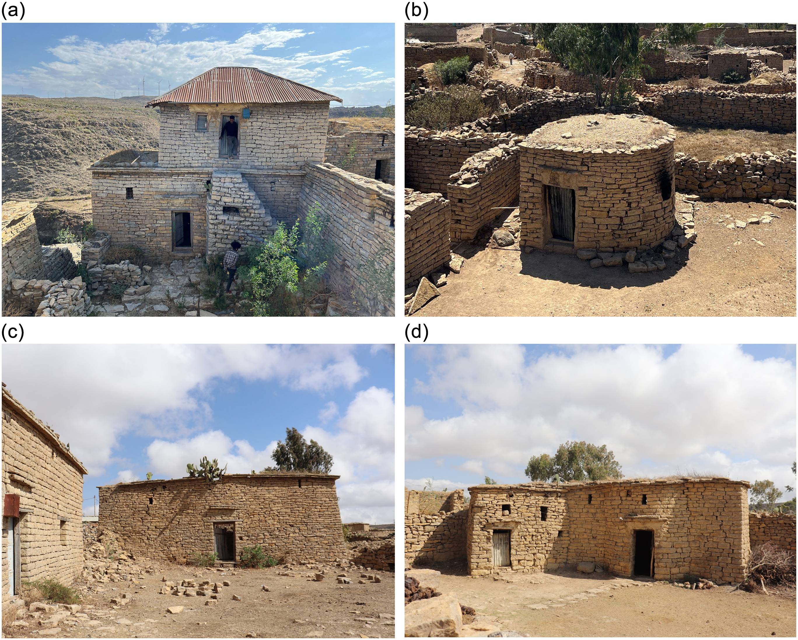
Vernacular architecture in Təgray, located in the northern highlands of Ethiopia, constitutes a vital element of the region’s cultural and historical heritage. This architectural typology is characterized by its reliance on indigenous construction techniques and locally sourced materials, which reflect a deep integration with the environmental, climatic, and socio-cultural conditions of the region. Among these structures, the hidmo stands out as the most iconic form – a traditional dwelling featuring robust masonry walls, wooden ceilings, and flat, soil-based roofs. These structures demonstrate remarkable adaptability to the semi-arid climate of Təgray, providing effective insulation and sustainable solutions to environmental challenges such as temperature fluctuations and limited rainfall. Complementing the hidmo are other significant vernacular forms, including rock-hewn structures carved directly into the landscape, and thatched-roofed dwellings, each of which underscores the ingenuity and resourcefulness of local architectural practices (Figures 1a–1d).
The preservation of Təgray’s vernacular architecture faces significant threats. Political conflicts, socio-economic pressures, urbanization, and environmental degradation have all contributed to the rapid deterioration of these buildings. The ongoing Təgray conflict has exacerbated the destruction of cultural sites, including churches and monasteries, complicating preservation efforts. Furthermore, the widespread adoption of modern construction techniques, which prioritize efficiency and cost-effectiveness, has marginalized traditional building methods, leading to the gradual erosion of indigenous knowledge. Environmental factors, such as increased rainfall and flooding, further jeopardize the structural integrity of many vernacular buildings, which are primarily constructed from mud and organic materials.
In response to these challenges, this project focused on documenting Təgray’s vernacular architecture, which has been undergoing rapid transformation. During the span of this field research, several buildings in Meqele City and the surrounding areas were demolished, often due to infrastructure expansion or the modernization of structures. By integrating archival research with advanced 3D documentation technologies, the project demonstrates a promising approach to preserving this architectural heritage. Archival research provided essential historical context, facilitating the identification of traditional construction techniques, architectural typologies, and the evolution of building practices over time. However, access to many of these archives has historically been limited, presenting challenges for researchers attempting to fully document Təgray’s architectural heritage.
The advent of 3D documentation technologies – such as laser scanning, photogrammetry, and drone-based imaging – has revolutionized architectural conservation. These technologies facilitate the creation of highly accurate digital models that capture intricate details, which would be difficult to record using traditional methods. These digital models serve as invaluable archival records and enable spatial analysis and virtual simulations, providing essential data to support restoration and conservation efforts.
This study aims to explore the potential of combining archival research with 3D documentation techniques to preserve Təgray’s vernacular architecture. By integrating historical context with advanced digital technologies, it seeks to develop a comprehensive and sustainable conservation strategy. This research contributes to the broader field of architectural conservation by demonstrating how interdisciplinary approaches can address the complex challenges of preserving vulnerable cultural heritage in conflict-prone and rapidly evolving environments.
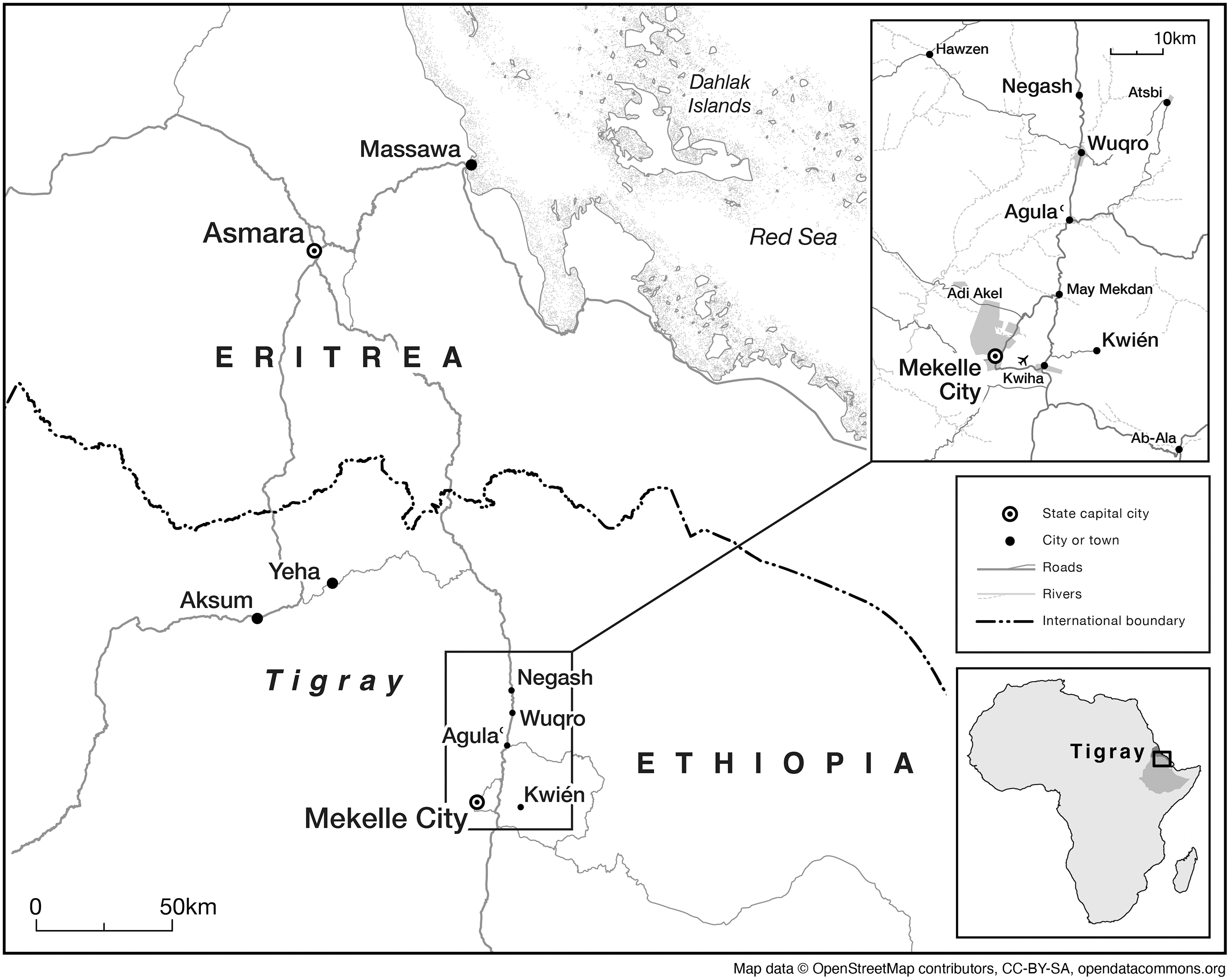
The project documented around fifteen sites as a pilot to assess the outcome. Three case studies, representing different typologies, are presented in this article as samples. These include the Ch’erqos Church in Wuqro, the Yohannes IV Palace (Kahsay Castle) compound in AgulaÊ¿, and a hidmo residence of the chief priest from Kwién Village. While much of the collected data still requires processing, the easily accessible data has been made available to the public. Examples of this include the 360-degree photography of many of the sites, which has been widely viewed by the public. The location of the documented sites is shown in the map provided (Figure 2).
Various shapes of hidmos in Kwién Village (a) multifloor; (b) detached circular; (c) detached rectangular; (d) mixed shape.Footnote 1

Map of research area.

Historical context
Təgray’s vernacular architecture offers a profound reflection of the region’s intricate historical and cultural evolution, showcasing a diverse array of traditional building forms shaped by millennia of human-environment interaction. Among the most prominent architectural typologies is the hidmo, a distinctive dwelling form that prevails throughout Təgray and the adjacent Eritrean highlands. The hidmo is characterized by its use of locally sourced materials, such as stone, wood, and earth, and employs construction techniques that have been finely tuned to the region’s environmental and climatic conditions. These structures typically feature masonry walls, wooden ceilings, and soil-based roofs, all of which are optimized to withstand the challenges of the highland climate, including seasonal rainfall, temperature fluctuations, and occasional flooding (Shimizu et al. Reference Shimizu2019b). While variations in the form of the hidmo exist, including multi-story, circular, rectangular, and mixed configurations (Figures 3a–3d), they all embody a deep integration with the surrounding natural resources, demonstrating both ecological and cultural sustainability.
The vernacular architecture of Təgray represents a key aspect of the region’s cultural and historical development, with diverse traditional building forms that are a direct response to the area’s environmental and socio-cultural conditions. The most prevalent architectural form in Təgray is the hidmo, a type of dwelling that is also common in the neighbouring Eritrean highlands. hidmos are constructed using locally sourced materials such as stone, wood, and earth, employing construction methods adapted to the region’s specific environmental and climatic factors. The typical structure includes masonry walls, wooden ceilings, and roofs made of soil or thatch. These building techniques have been optimized over generations to address the challenges posed by Təgray’s highland climate, which includes seasonal rainfall, temperature extremes, and occasional flooding (Shimizu et al. Reference Shimizu2019a). Variations of the hidmo include multi-story, circular, rectangular, and mixed forms, with typological classifications documented by scholars like Gebremedhin (Reference Gebremedhin and Oliver1971), all of which demonstrate a deep integration with the natural resources available in the region.
Beyond the vernacular hidmo dwellings, Təgray’s architectural heritage includes monumental structures from ancient periods, particularly the Aksumite civilization, which flourished between 350 BCE and 800 CE. The earlier Pre-Aksumite period is marked by advanced architectural practices, such as dry masonry construction, exemplified by the Yeha Temple. Built around the eighth century BCE, the Yeha Temple is one of the oldest surviving examples of dry masonry construction in sub-Saharan Africa (Phillipson Reference Phillipson2009). This structure not only demonstrates early technological expertise but also reflects the cultural and religious significance of the pre-Aksumite period. Təgray’s architectural history is further enriched by sites like May Adrasha, an archaeological settlement dating back to 1800 BCE, which has been heavily impacted by conflict, including subsistence digging and vandalism. The ruins at May Adrasha offer valuable insights into early settlement patterns and social organization.
The Aksumite civilization is also known for other monumental structures, including royal tombs, palaces, and churches, which reflect the region’s advanced engineering capabilities and its complex religious, political, and cultural dynamics (Bard et al. Reference Bard2014; Philipson Reference Phillipson2012). During the Aksumite period, the fusion of local construction techniques with external influences from Mediterranean and Arabian cultures played a pivotal role in shaping the region’s architectural evolution.
A significant legacy of Aksumite architecture is the rock-hewn churches, which are carved directly into the landscape, representing one of the most advanced forms of ecclesiastical architecture. These churches, carved from solid rock, feature intricate interior layouts, columns, archways, and decorative elements. They are also conditioned by geological factors influencing their orientation, carving technique, and material weathering (Asrat Reference Asrat2002). They function not only as religious spaces but also as key centres of community life and cultural identity (Plant Reference Plant1985; Finneran Reference Finneran2007; Tribe Reference Tribe2023). While there are fewer residential and funerary rock-hewn structures, the churches have been of particular interest to scholars, despite remaining largely unknown to foreign researchers until the mid-twentieth century. Lepage and Mercier (Reference Lepage and Mercier2005) provide one of the most comprehensive visual records. A comprehensive inventory of these rock-hewn churches across Eritrea, Təgray, and surrounding regions was created in 1963, categorizing them into three main types: churches built inside caves, hypogean churches, and monolithic churches (Sauter Reference Sauter1963). Subsequent research expanded this classification into six categories, including grottos, fully rock-carved churches, mixed structures, semi-monolithic churches, monolithic churches, and churches located within natural caves, with numerous examples found in Təgray and adjacent areas (Anfray Reference Anfray1985).
Throughout the nineteenth and twentieth centuries, the hidmo continued to dominate Təgray’s vernacular architecture. Simultaneously, other forms of construction developed, including multi-story buildings with thatched roofs and various architectural innovations. In recent years, thatched roofs have largely been replaced by corrugated iron sheet roofs. Significant examples of these developments include the Gunda Gundo Monastery main church and Abun Penteleon. The hidmo structure itself also evolved, with the largest example being the Palace of Yohannes IV, built in Meqele during the late nineteenth century. This palace reflects a hybridization of architectural styles, blending local and European influences in response to the shifting political and technological landscape (Shimizu and Asfha Reference Shimizu and Asfha2021).
The architectural heritage of Təgray is shaped by a continuous process of adaptation and innovation, where local materials and techniques are integrated with external influences in response to evolving environmental, political, and cultural contexts. This complex heritage not only reflects technological advancements but also embodies the region’s cultural identity and history. However, it is increasingly threatened by modern challenges, including political conflict, environmental degradation, and urbanization. A comprehensive understanding of the historical context of these buildings is crucial for developing effective conservation strategies that address both their physical preservation and cultural significance.
Challenges to preservation of vernacular architecture in Təgray
In Təgray, the preservation of vernacular architecture is at a critical juncture, shaped by rapid shifts in building practices, environmental pressures, and socio-political instability. The region’s rich architectural heritage, including iconic structures like the hidmo dwellings and rock-hewn churches, is increasingly threatened by both physical decay and cultural transformation. As traditional knowledge is lost and external influences reshape the built environment, documentation becomes essential to preserving the remaining architectural heritage in Təgray.
Conflict and political instability
The ongoing Təgray conflict has had a devastating impact on the region’s architectural heritage. Destruction from artillery, looting, and deliberate vandalism has led to significant losses, particularly to religious and secular vernacular buildings. Key structures, such as the Negash mosque and the Abune Amanuel Maebino church, were directly impacted by the conflict. In many cases, the damage was compounded by the loss of archival records that are crucial for understanding the original construction techniques and cultural significance of these sites. The current political instability has also hindered the establishment of preservation policies, leaving much of the region’s architectural heritage vulnerable.
Modernization and urbanization
Təgray has experienced rapid urbanization, particularly in cities like Meqele, where traditional hidmo structures have been replaced by modern buildings, a process that is part of a broader historical trend of urban development in Ethiopia (Pankhurst Reference Pankhurst1964; Reference Pankhurst1985). In the early 2000s, areas like Aynalem, which were once entirely composed of traditional hidmo houses, have undergone a rapid transformation, now characterized by concrete block houses with corrugated iron roofs. This shift reflects broader socio-economic pressures, where economic growth and the desire for modernization often take precedence over heritage conservation. This is consistent with findings on the urban transformation of Meqele by Okazaki (Reference Okazaki2014; Reference Okazaki2015). Many traditional buildings are demolished to make way for new developments, resulting in the loss of architectural practices that have sustained Təgray’s cultural identity for centuries.
Socio-economic pressures
The socio-economic challenges in rural and urban Təgray also contribute to the decline of traditional architecture. Communities are often forced to adopt cheaper, more readily available materials such as concrete and corrugated iron sheets. These materials, while practical, are poorly suited to the region’s climate and lack the cultural resonance of traditional construction materials like stone, wood, and thatch. The increasing cost of maintaining traditional hidmo houses and the limited availability of skilled labour to repair these structures have further accelerated the decline of vernacular architecture in the region.
Environmental degradation
Environmental pressures, particularly deforestation, have had a direct impact on the preservation of Təgray’s vernacular buildings. Traditional construction in Təgray relies heavily on locally sourced timber, especially from indigenous forests like the Dese’a forest, which once provided high-quality wood for building materials. However, unsustainable logging and legal restrictions on timber extraction have made it increasingly difficult to obtain these materials. As a result, many communities have resorted to modern, non-traditional materials that are more easily available but ill-suited to the region’s climatic and cultural needs.
Limited policy and institutional support
Təgray’s heritage faces additional challenges due to insufficient policy support and lack of institutional frameworks for conservation. Despite the region’s rich architectural history, there is no comprehensive policy that specifically targets the preservation of vernacular architecture. Limited financial resources allocated for heritage conservation, along with reliance on short-term projects funded by international organizations, have resulted in fragmented and unsustainable preservation efforts. The absence of a strong institutional framework for heritage management makes it difficult to address the region’s preservation needs effectively.
Lack of technical expertise
The preservation of Təgray’s vernacular architecture is further complicated by a shortage of skilled craftsmen who are trained in traditional construction techniques. The knowledge of these methods, passed down through generations, is at risk of being lost due to the decline in demand for traditional building practices and the increasing reliance on modern construction methods. This skills gap, combined with the lack of technical training programmes for heritage conservation, presents a significant obstacle to the preservation of Təgray’s architectural heritage.
Absence of comprehensive documentation and research
One of the most pressing issues in Təgray’s heritage preservation efforts is the lack of detailed, accessible documentation on vernacular architecture. While there are some archival materials and photographic records, they are often fragmented and dispersed across various institutions. The absence of comprehensive data on the architectural styles, construction techniques, and historical context of vernacular buildings impedes efforts to assess their significance and prioritize conservation interventions. Recent advances in 3D documentation and digital technologies offer promising solutions, but these methods require substantial investment and technical expertise to implement.
The shift away from traditional building practices in Təgray highlights the urgency of documenting the region’s architectural heritage before it is lost. Detailed documentation can help preserve the physical structures and safeguard the cultural knowledge embedded in these practices. As Təgray faces increasing challenges from conflict, environmental degradation, and modernization, the need for comprehensive and accessible documentation has never been more critical to ensuring the survival of its rich architectural traditions.
Archival research
Studies on archival research in architectural conservation
Archival research is essential for documenting and preserving vernacular architecture in Təgray, where historical records are often incomplete. Resources such as photographs, drawings, and ethnographic reports provide key insights into construction methods and socio-cultural contexts. Combined with field documentation, archival materials help reconstruct Təgray’s architectural heritage and guide conservation efforts, allowing for the tracing of architectural evolution in the region (Shimizu et al. Reference Shimizu2019b).
Təgray’s architectural studies remain under-researched, with fragmented collections from various archival sources both within Ethiopia and internationally. Key repositories in Ethiopia include the Institute of Ethiopian Studies (IES), which holds ethnographic studies, maps, and early architectural records from the Ethiopian Archaeology Institute and the Ethio-Swedish Building College. The Ethiopian Mapping Agency provides vital topographic maps that offer geographical context for architectural sites, while the National Archives and Library of Ethiopia preserve rare manuscripts, government records, and cartographic materials. All these collections have a very limited digital presence and access.
Internationally, key archives support the study of Təgray’s architectural heritage. The Frobenius Institute in Frankfurt holds ethnographic reports, while the Staatliche Museen zu Berlin preserve materials from the Deutsches Aksum Expedition (Littmann et al. Reference Littmann2005). The Archivio Storico Istituto Italo-Africano contains documentation from the Italian occupation. The British Museum, Smithsonian Institution, Library of Congress, and French Centre for Ethiopian Studies (CFEE) hold important maps, ethnographic reports, and architectural drawings. National archives like those in Ethiopia, the British Library, and university collections (University of California, Los Angeles (UCLA), University of Chicago) provide significant cultural and historical resources, supporting ongoing research on Ethiopia’s heritage.
Historical expeditions have played a key role in documenting Təgray’s architecture. Early accounts, like those by Francisco Álvares in the sixteenth century, focused more on the cultural and religious importance of Aksum than on architectural details. In the nineteenth century, explorers like Theodore Bent recorded Aksumite artifacts and structures, though often with a colonial perspective. The Deutsches Aksum Expedition in 1906 was one of the first to systematically study the region’s architecture, producing detailed surveys and photographs. Later, in the mid-twentieth century, scholars such as A. Mordini (Reference Mordini1953), Roger Sauter (Reference Sauter1963) and Georg Gerster (Reference Gerster1970; Reference Gerster1974) further documented architectural forms, materials, and construction techniques, contributing to a deeper understanding of Təgray’s architectural heritage.
Previous research highlights the significance of archival materials in understanding the development of architectural styles in Təgray. Studies by Okazaki (Reference Okazaki2009), Shimizu et al. (Reference Shimizu2019a; Reference Shimizu2019b) and Shimizu and Asfha (Reference Shimizu and Asfha2021) have extensively used archival documents to investigate the evolution of hidmo houses, the urbanization of Meqele, and the preservation of local heritage. These materials not only document the physical characteristics of buildings but also reveal the socio-cultural and environmental factors that influenced their construction. Ethnoarchaeological research supports this, highlighting how architecture shapes and is shaped by social power structures in rural Tigray (Lyons Reference Lyons2007). Research on Meqele’s urban development, for example, shows how architectural forms adapted to changing social and economic conditions, leaving a lasting impact on building typologies. However, accessing these resources remains challenging due to their dispersion across international archives. Despite this, digitization initiatives have improved access, enabling more effective integration of archival research with fieldwork. This combination of historical data and contemporary investigation has enhanced the understanding of Təgray’s architectural evolution.
The integration of archival research with modern field techniques has been demonstrated in the study and conservation of key sites in Təgray. For example, the Ch’erqos Rock-hewn Church (Case study 1) benefits from a blend of archival materials – such as earlier works by Roger Sauter (Reference Sauter1963), David Buxton (Reference Buxton1971a; Reference Buxton1971b), Georg Gerster (Reference Gerster1974), and Ruth Plant (Reference Plant1985) – along with contemporary 3D documentation technologies. Early photographs and architectural drawings from these archives were used to trace the church’s structural development, which was then enhanced by 3D scanning data to create a detailed digital model. This fusion of historical and modern data allows for a more comprehensive evaluation of the church’s structural condition and conservation needs.
Although the Kwién Residence (Case study 3) lacks direct early documentation, the hidmo typology underscores the importance of archival research in understanding Təgray’s architectural development in the nineteenth and twentieth centuries. Archival materials from the Frobenius 1913 expedition and the 1965 Ethio-Swedish Housing Survey in Meqele, and the work of Naigzy Gebremedhin (Reference Gebremedhin and Oliver1971) – including architectural plans, photographs, and correspondence – have shed light on the historical progression of this residential typology. When combined with modern 3D modeling, these resources have aided in reconstructing the building’s architectural evolution.
The conservation of AgulaÊ¿ Castle (Case study 2) relies heavily on archival documents from multiple sources to reconstruct the site’s architecture. Historical maps, architectural drawings, and 3D scanning data have already provided a detailed understanding of the castle’s current state. These resources are crucial in documenting the castle’s design, including the engineering innovations that ensured its survival. The integration of these archival materials plays a significant role in preserving the historical authenticity of the castle while maintaining its structural integrity.
In regions like Təgray, where formal documentation may be limited, supplementary sources such as oral histories and local knowledge are invaluable in filling gaps in the archival record. Oral traditions, passed down through generations by local builders, provide critical insights into construction techniques, material selection, spatial organization, and roof design. When documented alongside archival materials, these oral accounts offer a more comprehensive understanding of the cultural significance and functionality of traditional buildings (Shimizu et al. Reference Shimizu2019a).
Innovative documentation approaches (for new archives)
Advances in 3D documentation technologies
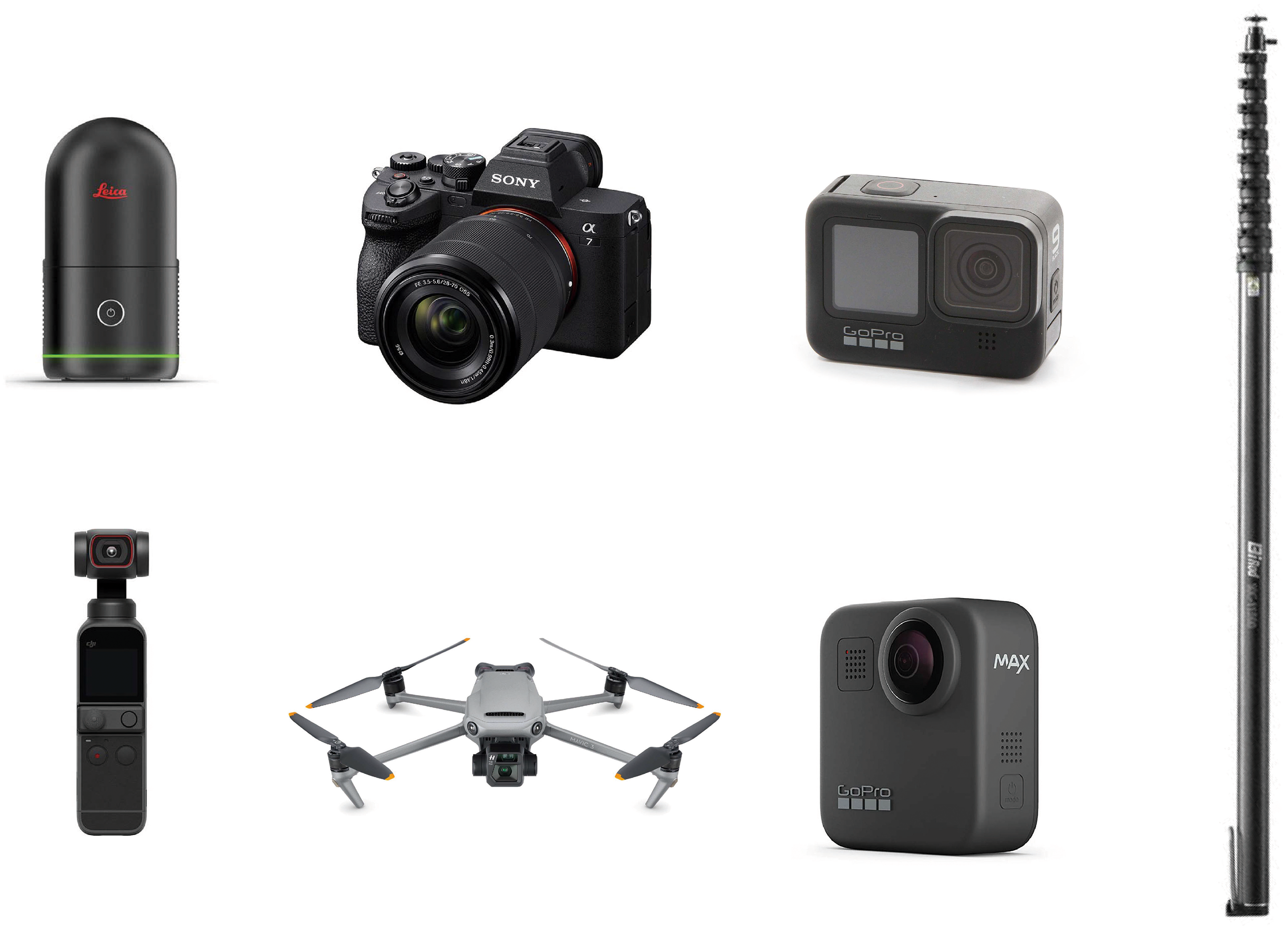
Recent advancements in 3D documentation technologies have greatly improved the preservation and analysis of architectural heritage, providing unprecedented accuracy in capturing intricate details of vernacular architecture. Key tools like photogrammetry, laser scanning, and drone-based imaging enable the creation of high-resolution, spatially accurate digital models of structures. These models are crucial for thorough assessment and conservation, offering detailed insights into the condition and historical integrity of architectural sites. The range of digital tools employed in this study is illustrated in Figure 4, which shows the core devices used by the research team for data collection.
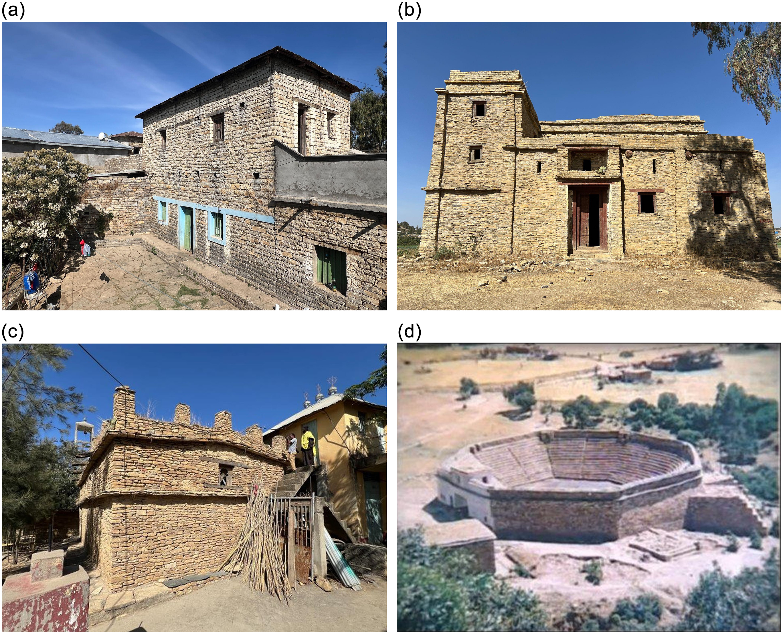
Various functions of hidmos (a) Residence in Aynalem, Meqele; (b) Castle in Feleg Daéro Meqele; (c) hidmo church in Kidane Mihiret, Agulaʿ; (d) Theatre, Édaga Aʿrbi, Ahferom.

Equipment used for digital heritage documentation includes Leica BLK360, Sony Alpha 7 IV, GoPro HERO11 Black, DJI Mavic 3, DJI Osmo Pocket 2, GoPro MAX, and a telescoping pole. Sources: Leica Geosystems 2023; Sony 2023; GoPro 2023; DJI 2023; Insta360 2023.

Photogrammetry uses overlapping photos to create 3D reconstructions, ideal for capturing complex structures like rock-hewn churches. It produces detailed 3D models for virtual analysis, monitoring, and planning conservation interventions.
Laser scanning, using LiDAR (Light Detection and Ranging), enhances documentation by emitting laser pulses to create dense point clouds with sub-millimetre accuracy. This method is ideal for capturing large-scale features and complex structures, like rock formations or aged masonry, where traditional methods fall short. The precision of laser scanning aids in analysing structural stability and identifying potential risks.
Drone-based imaging, although restricted by regulations, can efficiently capture aerial data of large or hard-to-reach sites. Using high-resolution cameras, drones generate orthophotos and topographic maps, contributing valuable spatial data. When combined with other technologies, this data helps monitor site degradation, analyse material conditions, and assess environmental impacts on structures (Stylianidis and Remondino Reference Stylianidis and Remondino2016).
The use of 3D documentation methods improves the accuracy and accessibility of architectural data, creating digital models that serve as key records for restoration and conservation efforts. These models allow for the simulation of potential interventions and provide a platform for long-term monitoring. Additionally, they support virtual reconstructions, enabling experts to assess conservation scenarios before implementing physical changes. This digital preservation fosters greater collaboration among researchers, heritage professionals, and the wider community, ensuring critical data is available for future study and intervention.
The integration of 3D technologies in architectural conservation captures physical forms with high accuracy and provides an analytical framework to assess architectural integrity and design preservation strategies. These advancements help preserve both tangible and intangible aspects of cultural heritage, ensuring the effective conservation of vernacular architecture in Təgray and similar regions for future generations.
Although the use of 3D documentation technologies is not yet widespread in Ethiopia, initiatives like the Zamani Project are advancing these tools. By utilizing digital tools such as 3D modeling and GIS data, the project helps document and preserve heritage sites, creating a new type of archive that complements traditional methods and broadens preservation strategies. (Zamani Project [n.d.])
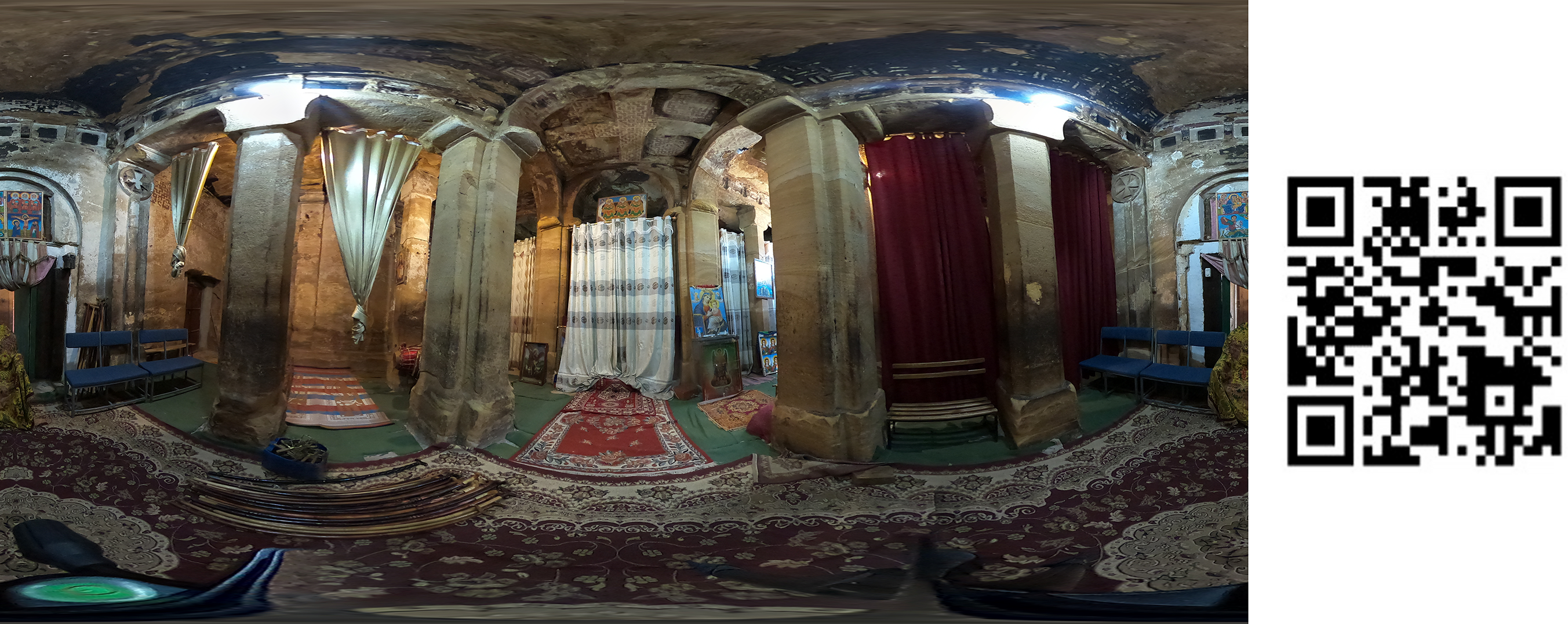
This research project also made some of the documentation publicly accessible. One such initiative is a 360-degree photo tour of the research sites, which garnered over 4,000 views in its first three months. The photos are available for viewing via a QR code (Figure 5).
QR code linking to a digital archive of 360-degree photographs collected by the research team.

Field study insights
The field study for this research surveyed fifteen sites in Təgray, Ethiopia, focusing on vernacular architectural structures. These sites were selected based on accessibility and their representation of distinct architectural typologies. Due to logistical challenges following the Təgray conflict, the study concentrated on sites along the Meqele-Adigrat road, which facilitated detailed documentation. Three representative sites were selected for in-depth analysis: Ch’erqos Rock-hewn Church, Kwién Residence, and AgulaÊ¿ Castle. Each site highlights unique architectural, cultural, and historical aspects of Təgray’s vernacular heritage.
Methodology and documentation techniques
The field documentation integrated both advanced digital technologies and traditional methods to ensure a thorough analysis of the vernacular architectural sites. Terrestrial laser scanning (TLS) and photogrammetry were employed to capture high-resolution spatial data, generating accurate 3D models of the structures. These models enabled precise assessment of geometry, volumetrics, and spatial organization. In addition, traditional measurement techniques and hand-drawn documentation were conducted to cross-verify the accuracy of the digital models. The incorporation of these conventional methods acknowledges the importance of local practices and resource limitations, which remain crucial in many heritage documentation efforts.
Case study 1: Ch’erqos Rock-hewn Church
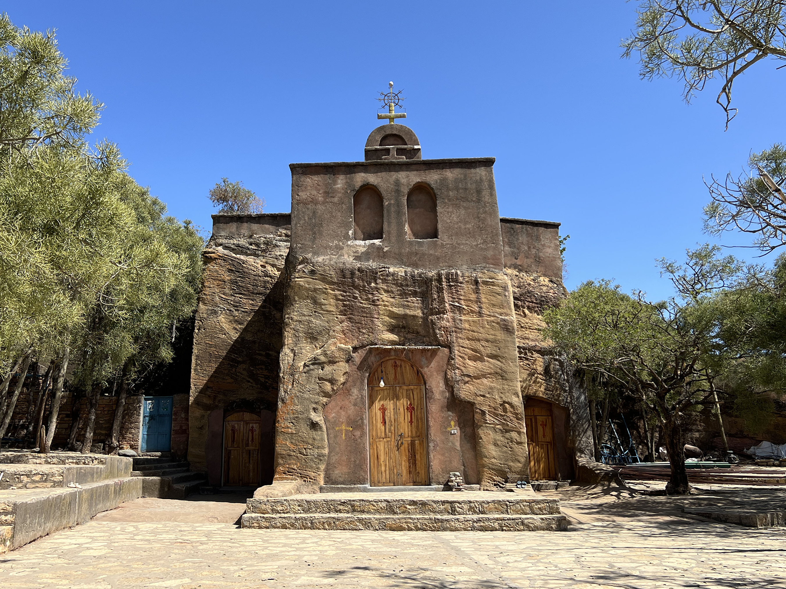
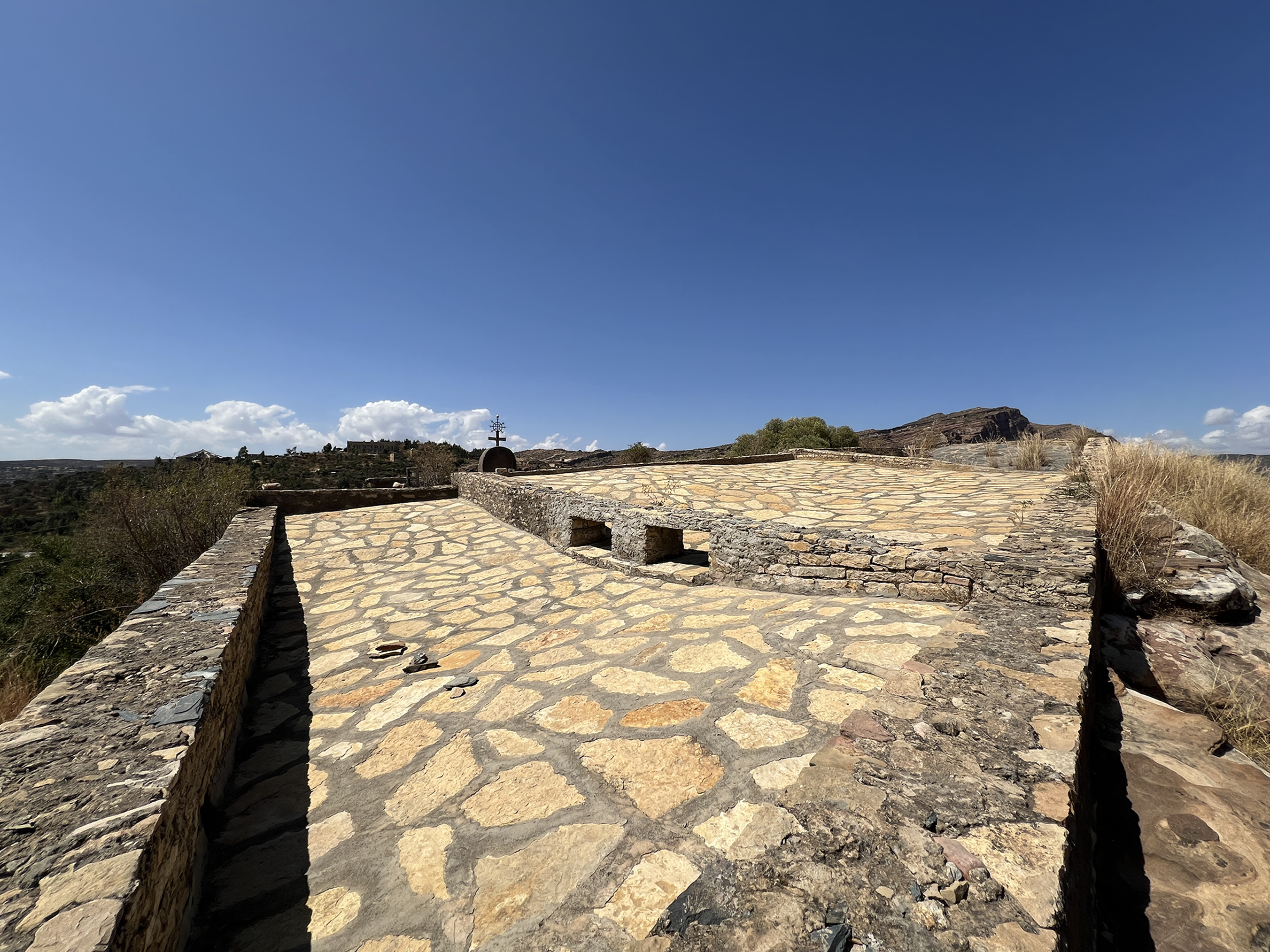
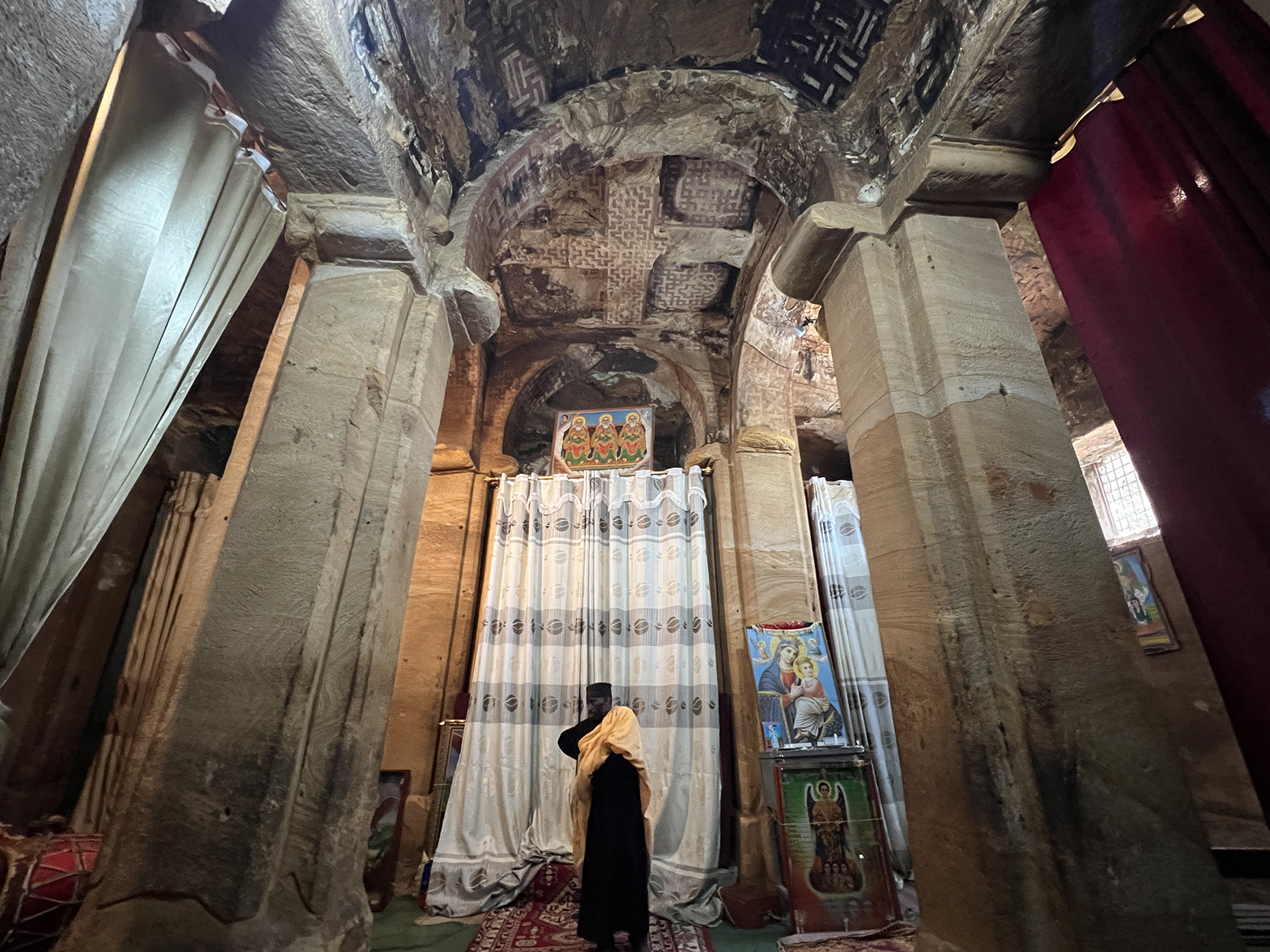
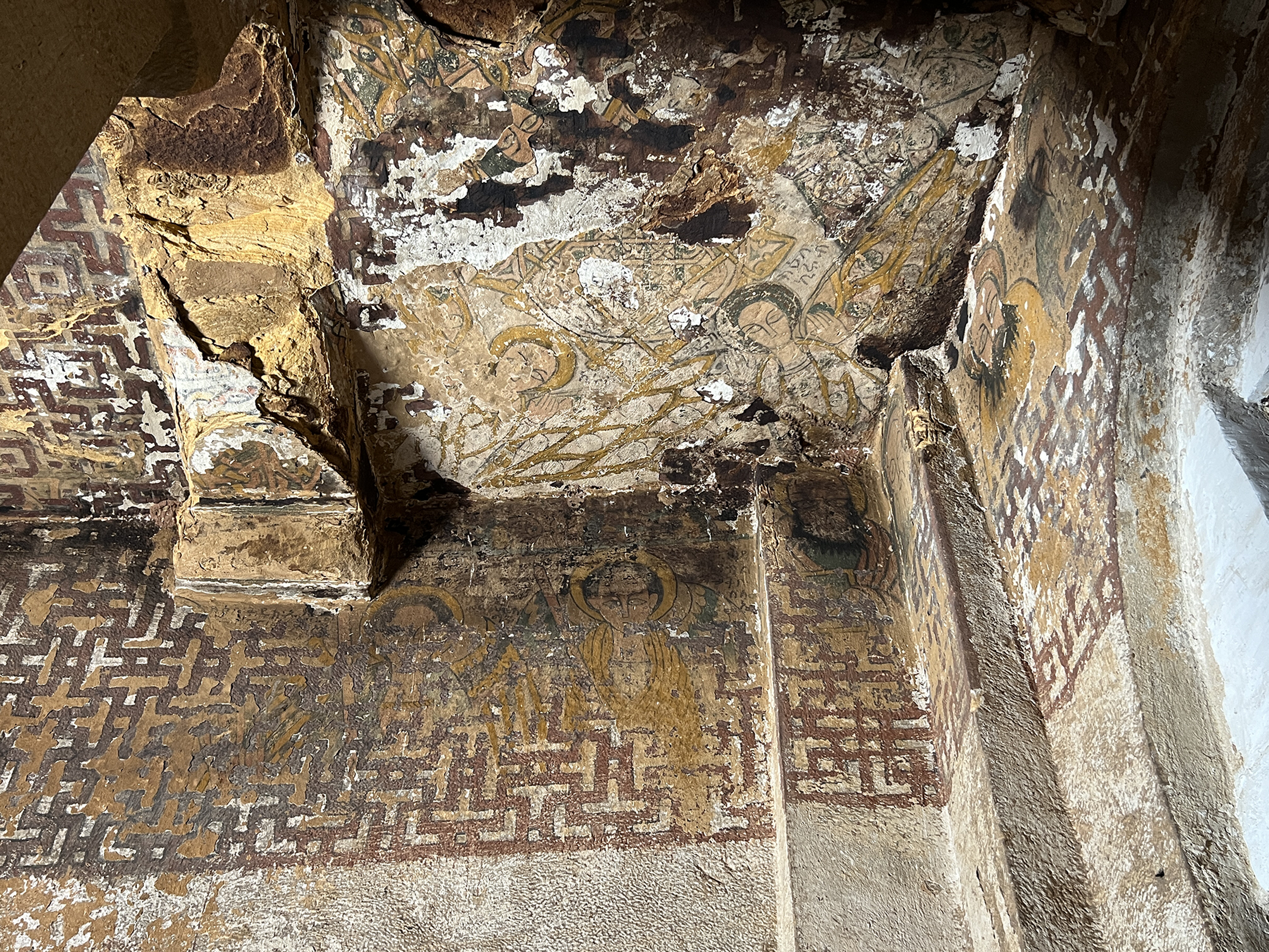
The Ch’erqos Rock-hewn Church, a monolithic structure carved into the hillside, is a significant example of Təgray’s ecclesiastical architecture. 3D scanning conducted during this study revealed detailed features of the façade and interior, including columnar supports, arches, and iconographic carvings, which show a combination of Aksumite and early Christian architectural styles. Spatial analysis indicates that the church’s orientation is aligned with solar trajectories, suggesting an advanced understanding of celestial patterns in its design. Figures 6a and 6b show the current exterior and rooftop conditions of the site, while interior views and frescoes are highlighted in Figures 7a and 7b. Structural assessments revealed weathering and fissures, exacerbated by rainfall and surface runoff, requiring immediate conservation attention. While the church is well-known and frequently studied, the 3D scans showed slight deviations from previous measurements, particularly in the organic appearance of the columns compared to earlier documentation.
Left: Exterior view, Ch’erqos Rock-hewn Church (2024).

Right: Rooftop view, Ch’erqos Rock-hewn Church (2024).

Left: Interior view, Ch’erqos Rock-hewn Church (2024).

Right: Fresco paintings, Ch’erqos Rock-hewn Church (2024).

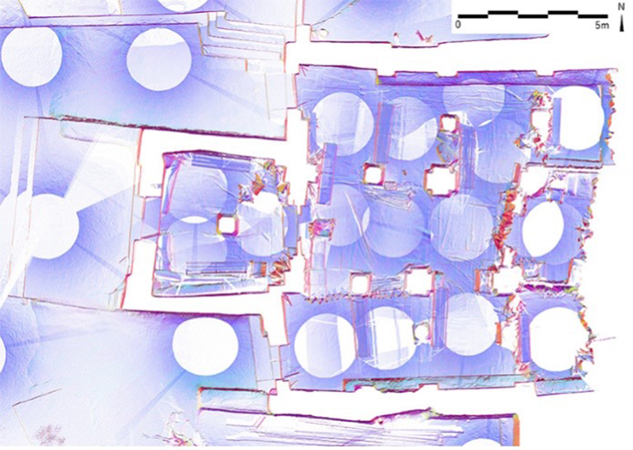
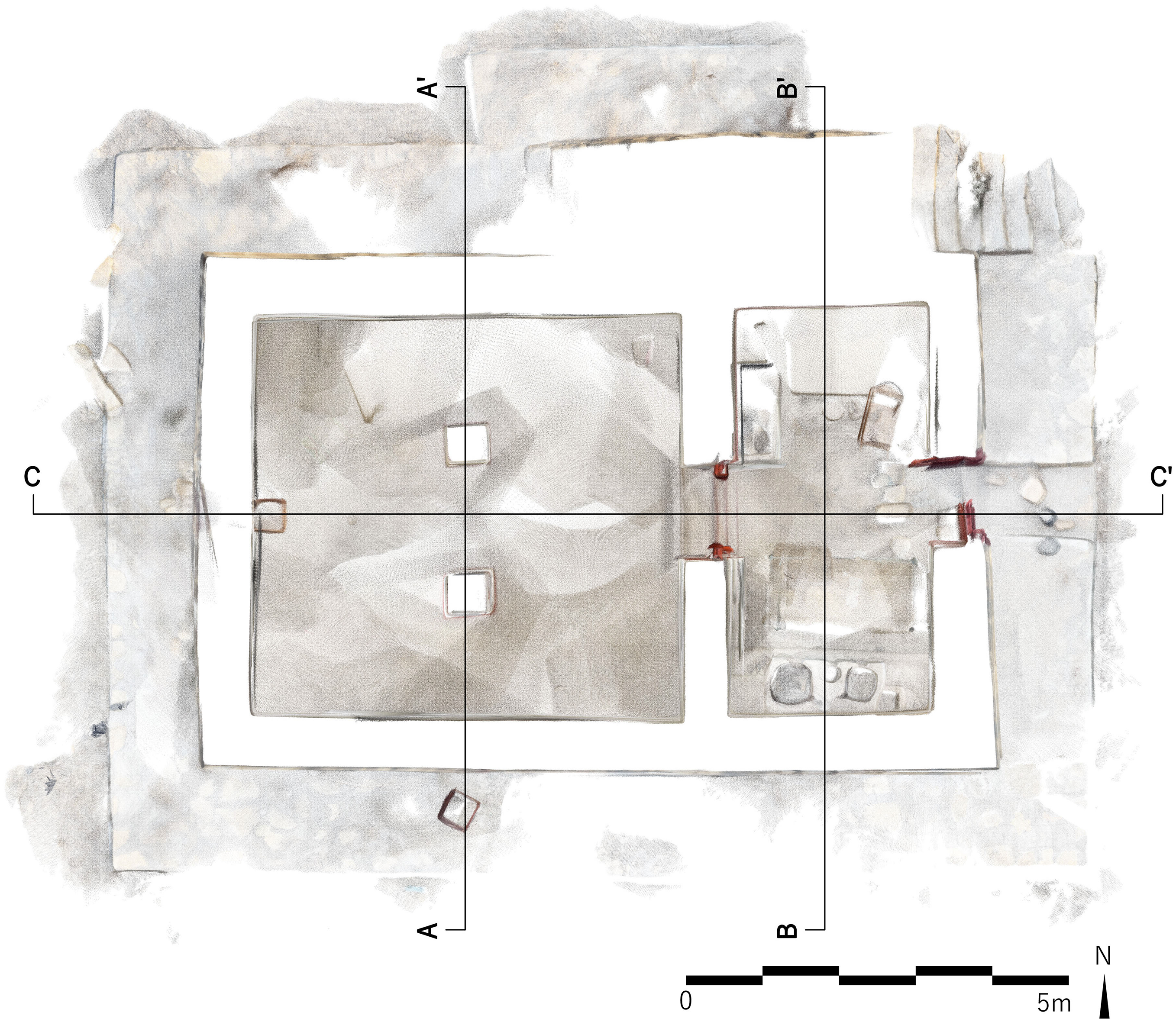
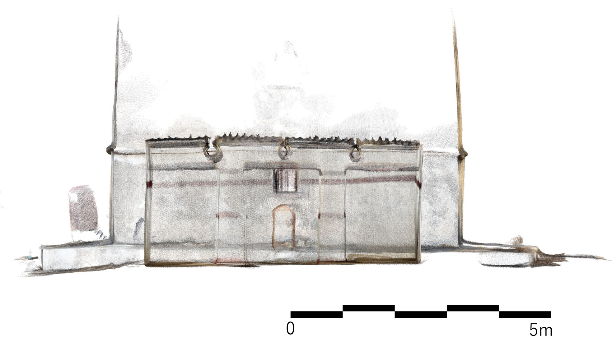
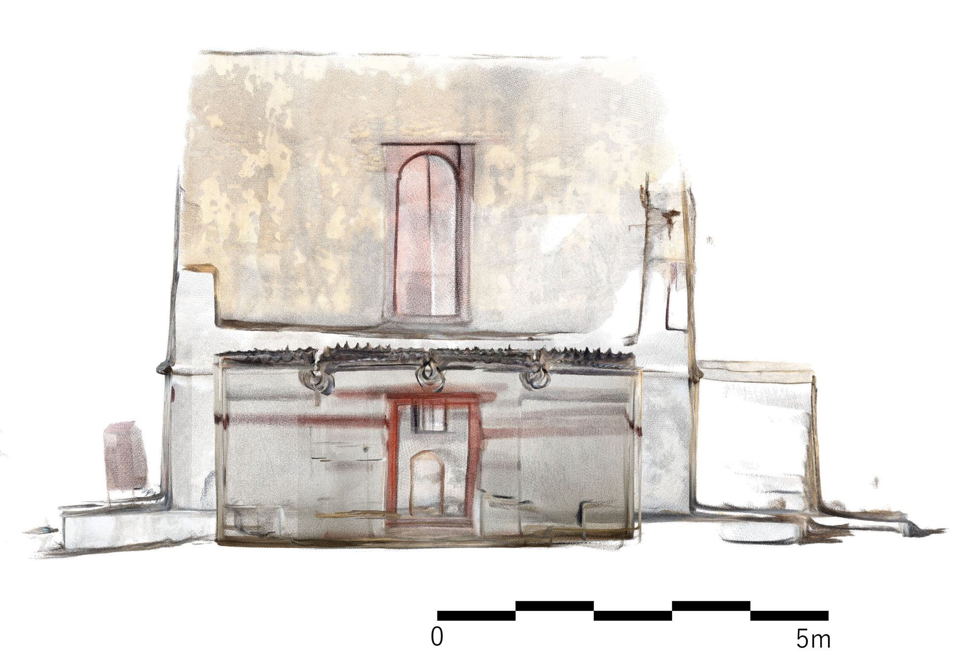
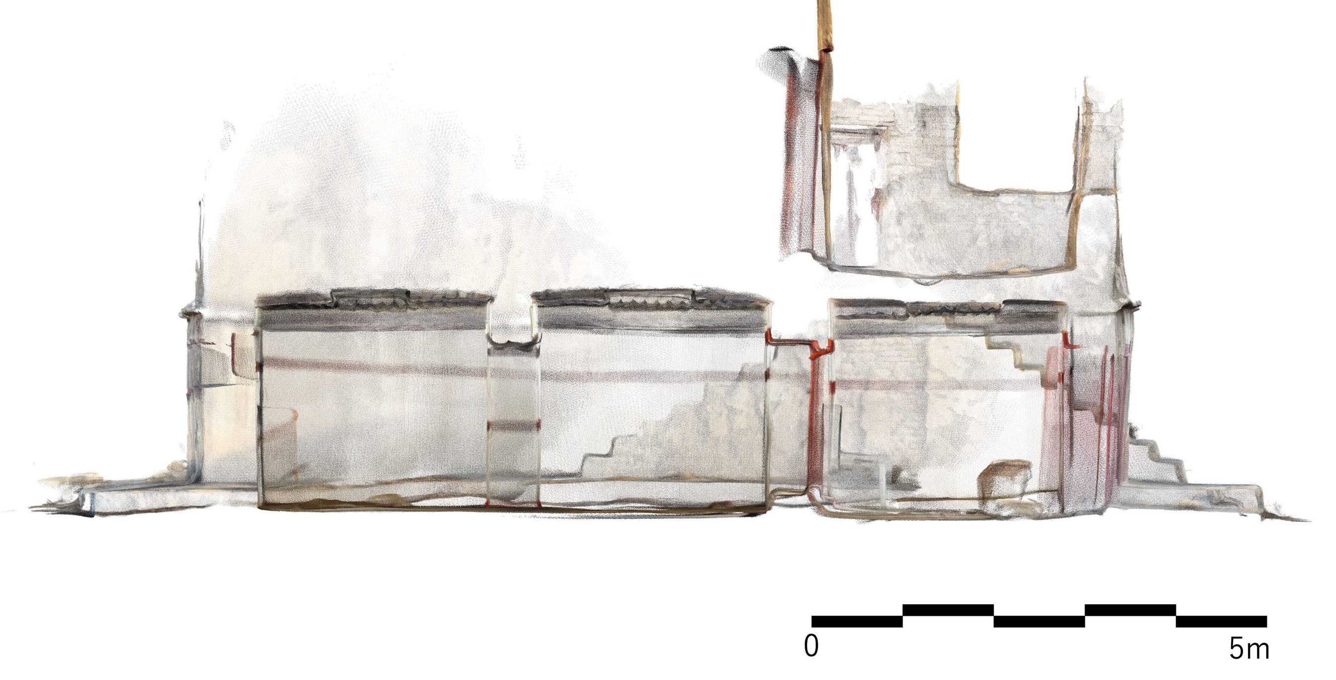
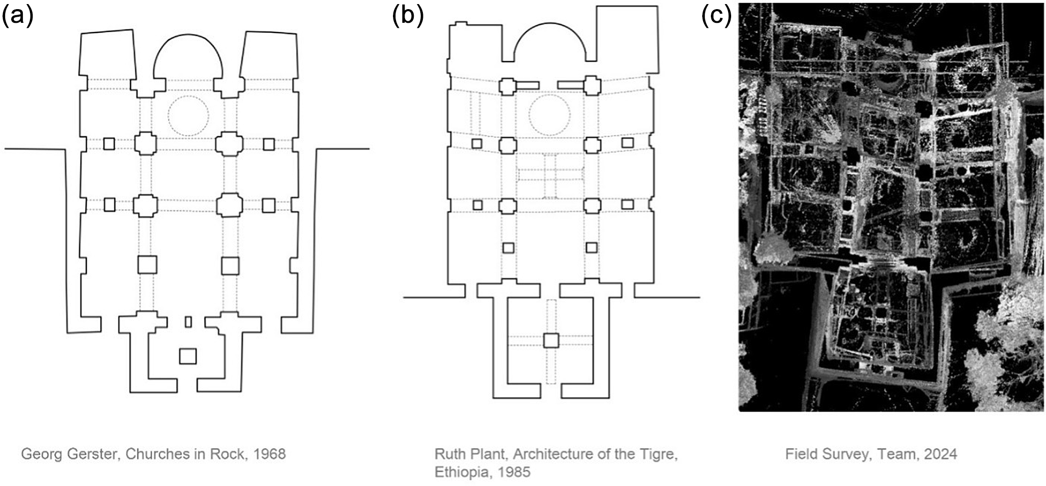
The architectural plans of the Ch’erqos Rock-hewn Church have been previously documented by Gerster (Reference Gerster1970), Buxton (Reference Buxton1971a; Reference Buxton1971b) and Plant (Reference Plant1985). Using point cloud data from laser scanning, the current research team produced a 360-degree photo overview (Figure 8) and a new plan (Figure 9a), which is also publicly accessible via QR code. A comparative analysis of the new data with earlier plans reveals a distortion in the building’s shape, now exhibiting a parallelogram-like form. In addition, precise sectional drawings have been developed to further improve the documentation and understanding of the structure.
360-degree photo, Ch’erqos Rock-hewn Church, also accessible with the QR code (2024).

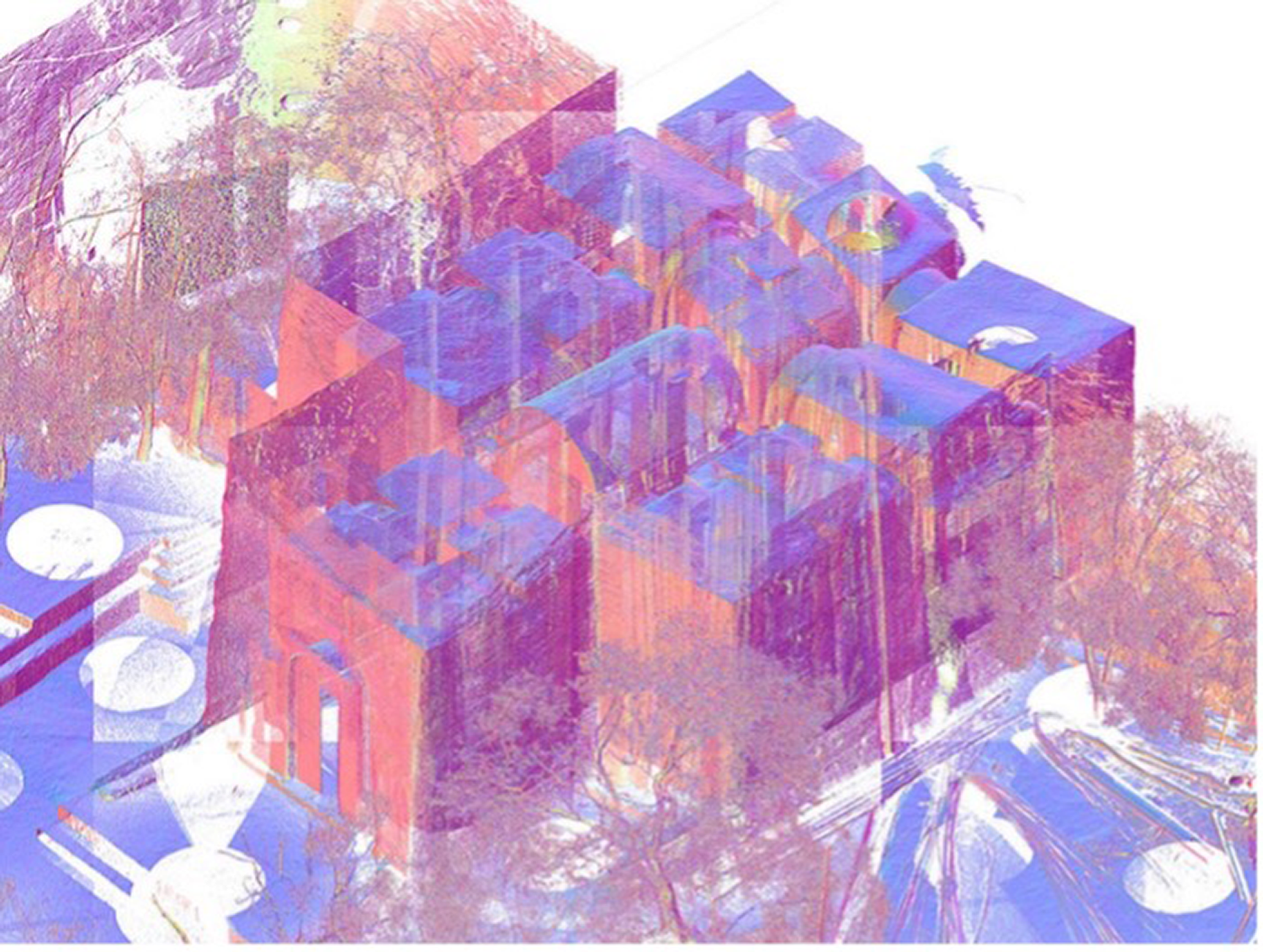
Left: Perspective view (cut above the ceiling) from point cloud data, Ch’erqos Rock-hewn Church (2024).

To support detailed architectural understanding, perspective views and sections were extracted from the point cloud data (Figures 9b, 10a and 10b), capturing both longitudinal and transverse profiles. These outputs significantly enhance the documentation precision and enable improved conservation planning. White circles in Figure 9a indicate the scan station locations.
Right: Plan created from point cloud data, Ch’erqos Rock-hewn Church (2024). White circles indicates where the scan was taken.

Left: Longitudinal section A-A’ created from point cloud data, Ch’erqos Rock-hewn Church (2024).

Right: Transversale section B-B’ created from point cloud data, Ch’erqos Rock-hewn Church (2024).

Case study 2: Emperor Yohannes IV Agulaʿ Castle
AgulaÊ¿ Castle, also known as Kahsay Castle, holds significant historical and architectural value in northern Ethiopia. Located near a small river flowing into the Giba River, approximately twenty-five kilometres northeast of Meqele along the Meqele-Adigrat road, the castle was established in the early 1870s by Emperor Yohannes IV (formerly Kahsay). Historical accounts attribute its construction to Dejazmach Gebre Sïllase, under the directive of Yohannes IV. However, the castle served only briefly as his base before he moved his camp to Meqele, and it was later donated to a local monastic community.
Agulaʿ Castle predates the more renowned Yohannes IV Palace in Meqele and is believed to have been constructed without foreign assistance. The site underwent several renovations, including early interventions by Italian architect, Giacomo Naretti, and significant restorations in 2009 and 2020. These renovations require careful analysis to distinguish original elements from later modifications. Figure 11 shows an example of earlier documentation based on manual tape measurements. Recent conflicts have also impacted the site, resulting in the death of the site manager and the looting of museum collections.
Previous documentation of Kahsay Castle measurements taken using tape (Shimizu and Asfha Reference Shimizu and Asfha2021).

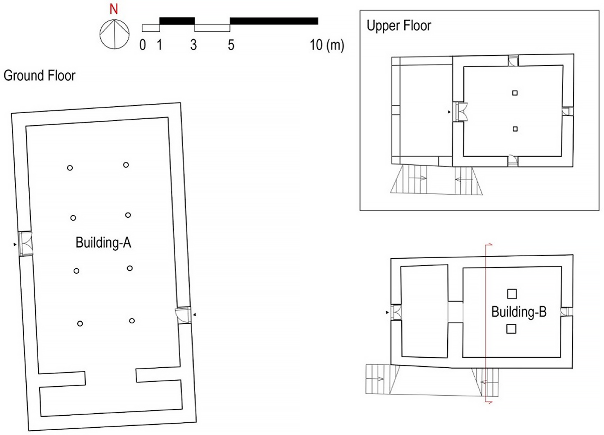
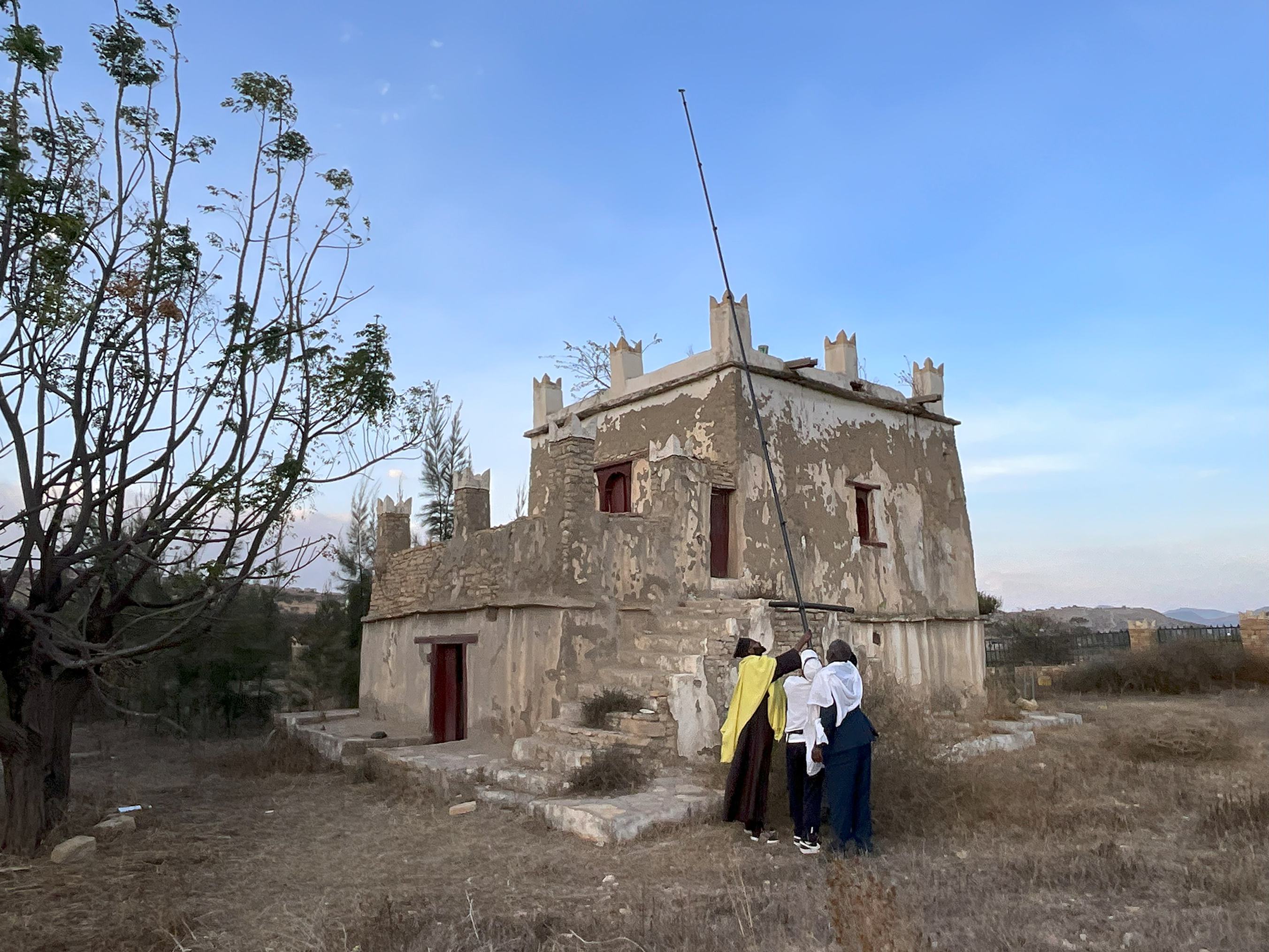
The Agulaʿ Castle complex consists of two main structures (Figures 12a and 12b), referred to as Building A and Building B, which are not surrounded by defensive walls. Building A is a single-story hall, locally known as aderash, measuring approximately 10 by 18 metres. It has two doors, one on the east side and one on the west, leading into a large interior space supported by eight wooden pillars. The ceiling height reaches 5.5 metres, providing an open environment suitable for gatherings. However, the small and poorly placed windows result in limited natural lighting. The roof structure features a V-shaped wooden arrangement, a distinctive characteristic of hidmo architecture (Figures 13a and 13b).
Left: Exterior view, aderash (Building A), Agulaʿ Castle (2024) Residential building, Agulaʿ Castle (2024).

Right: Exterior view, Residential building (Building B), Agulaʿ Castle (2024).

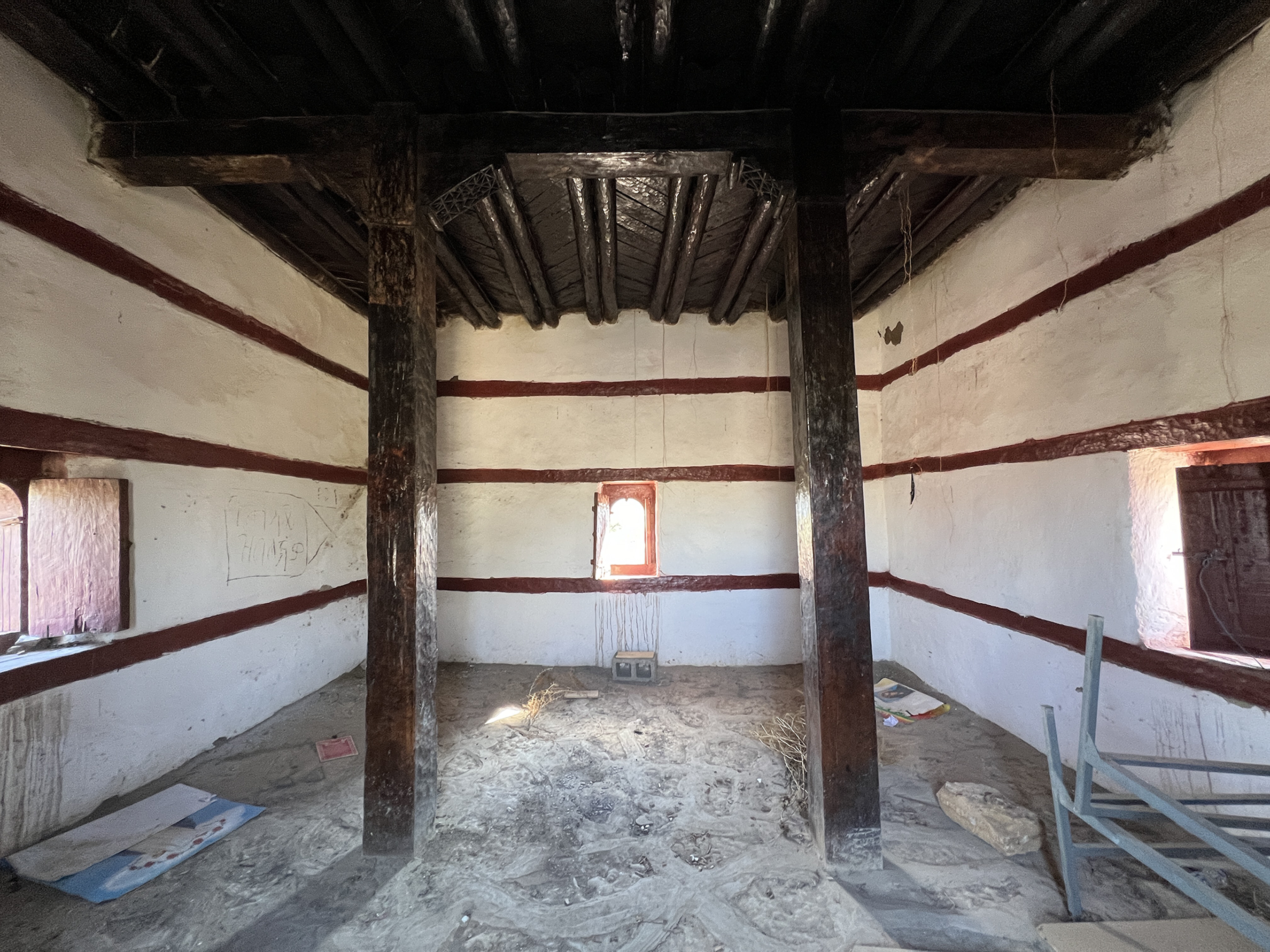
Left: Interior view, first floor, Residential building, Agulaʿ Castle (2024).

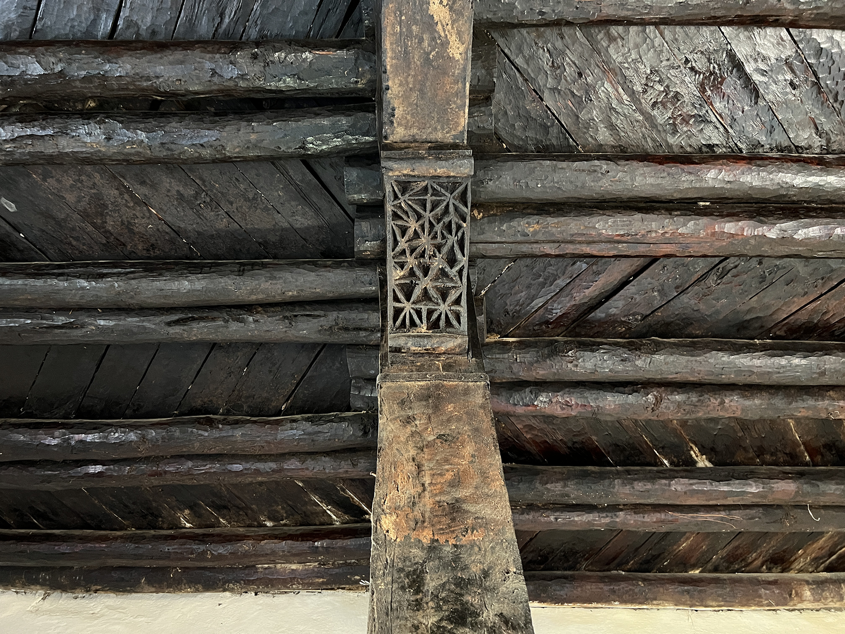
Right: Ceiling detail, first floor, Residential building, Agulaʿ Castle (2024).

Approximately 10 metres to the east of Building A is Building B, a two-story residential structure with a footprint of 10 by 6 metres. The upper floor serves as the main living area, featuring a terrace accessible via stairs on the south side. The main room, with a ceiling height of 3.5 metres, is supported by two wooden pillars and receives ample natural light through windows on three sides. In contrast, the ground floor consists of two rooms with a ceiling height of about 2 metres. This level, accessed separately through a western door, likely served practical functions such as storage, servant accommodations, or an animal shed. Stone pillars on the ground floor support the wooden beams of the upper floor, demonstrating a practical use of materials.
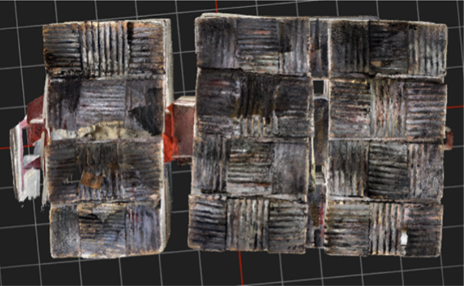
The architectural features of AgulaÊ¿ Castle reflect a fusion of vernacular traditions and unique stylistic elements. Building A’s stringcourses along the south and north walls exhibit a gentle slope, contrasting with the level interior ceiling. Both buildings feature horizontal wooden beams embedded in the walls, serving both structural and decorative purposes. In Building B, the upper floor includes three prominent layers framing the openings. Doors and windows in both buildings are decorated with wooden bead-planks, enhancing the aesthetic value. Wooden pillars in both buildings have bracket capitals, with those in Building B’s upper floor displaying intricate geometric carvings. In contrast, the stone pillars on the ground floor are plain, emphasizing their functional role. Ceiling designs in both buildings are V-shaped, typical of hidmo architecture, with Building B’s upper floor using larger wooden planks, while the ground floor uses heavier log-like beams for added rigidity. The wooden ceiling design is illustrated in Figure 14. Both buildings feature decorative rooftop cuboids, though they serve no functional purpose.
The design and materials of AgulaÊ¿ Castle reflect a hierarchy of formality and status. The upper-floor room of Building B, with its intricately carved brackets and superior materials, is the most formal space, indicating its prominence within the complex. Similarly, the ornamental doors in both buildings emphasize the status of their respective entrances. The use of Juniperus wood (tsehïdi), a prestigious material, further underscores the site’s importance. Comparative analysis reveals parallels between the ornamental and structural features of AgulaÊ¿ Castle and those of the Michael Church at Feleg Da’ïro, suggesting a shared cultural and architectural vocabulary. This indicates that the imperial residence adopted local vernacular forms to express authority and formality.
AgulaÊ¿ Castle stands as a testament to the vernacular ingenuity and socio-political dynamics of nineteenth-century Ethiopia. Its architecture blends practicality, cultural expression, and imperial ambition, offering valuable insights into the region’s historical and architectural heritage.
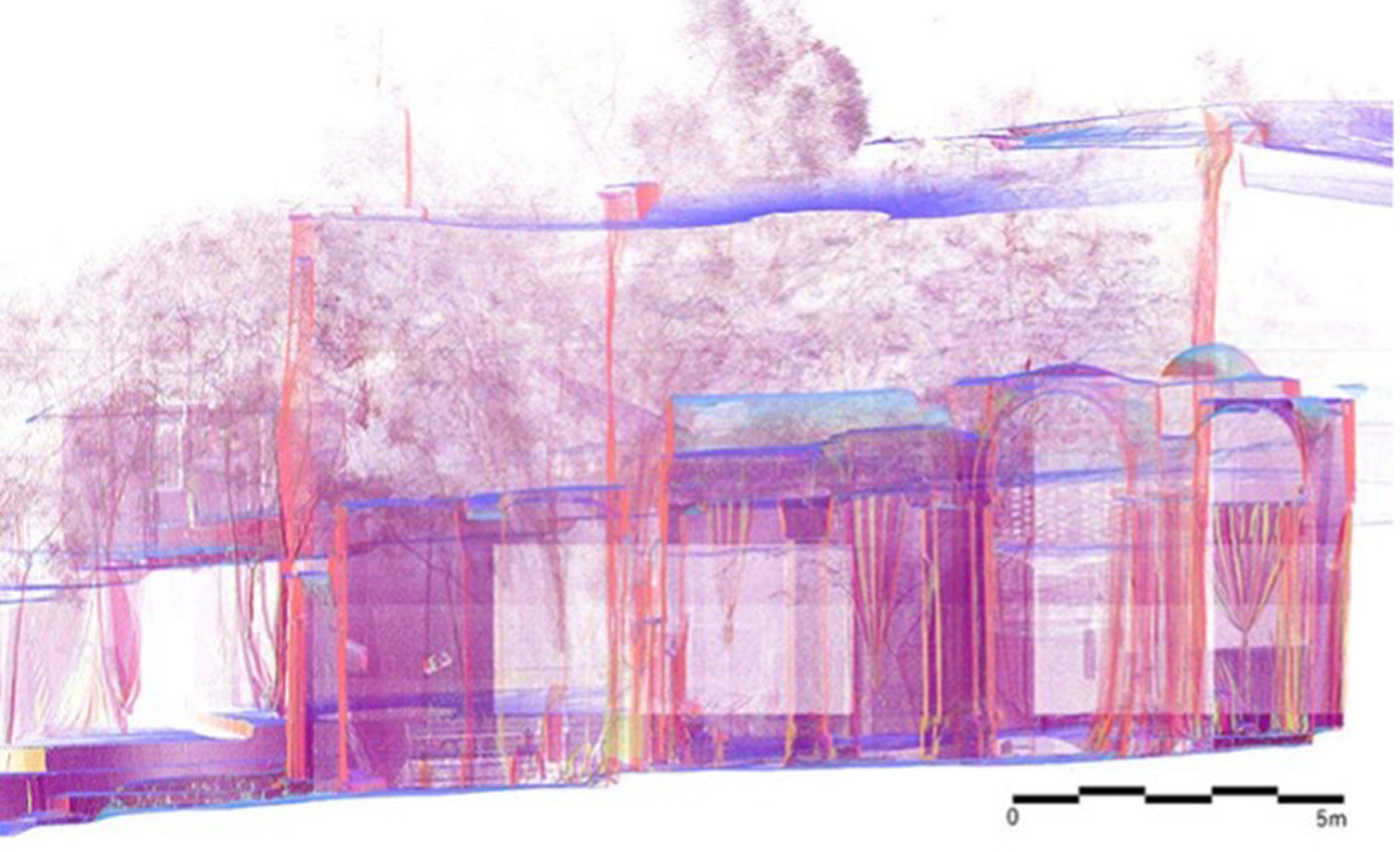
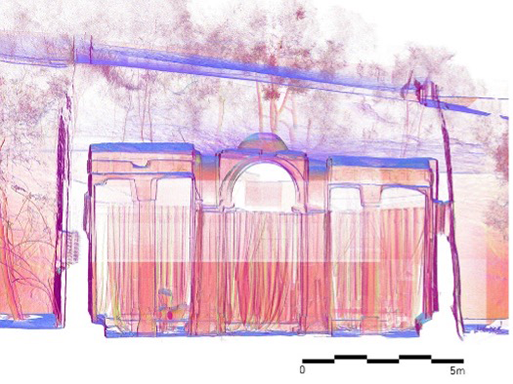
Previous measurements of AgulaÊ¿ Castle were recorded manually with a tape measure (Figure 11). For this research, point cloud data was acquired using an iPhone 13 Pro combined with the Sitescape Pro application. While Sitescape offers a convenient and efficient way to capture an overview of the space and perform preliminary measurements, it is prone to measurement inaccuracies. Nonetheless, the resulting outputs – such as the plan (Figure 15), transversal sections (Figures 16a and 16b), and longitudinal section (Figure 17) – enable a deeper spatial analysis of the residential building’s ground floor and support a comparative study with earlier records.
Wood ceiling plan of Agulaʿ Castle, 2024.

Plan, ground floor, residential building, Agulaʿ Castle (2024).

Right: Transversal section B-B’, ground floor, residential building, Agulaʿ Castle (2024).

Left: Transversal section B-B’, ground floor, residential building, Agulaʿ Castle (2024).

Longitudinal section C-C’, ground floor, residential building, Agulaʿ Castle (2024).

Case study 3: Residence of Riese Debri GebreMaryam in Kwién (Kwién Residence)
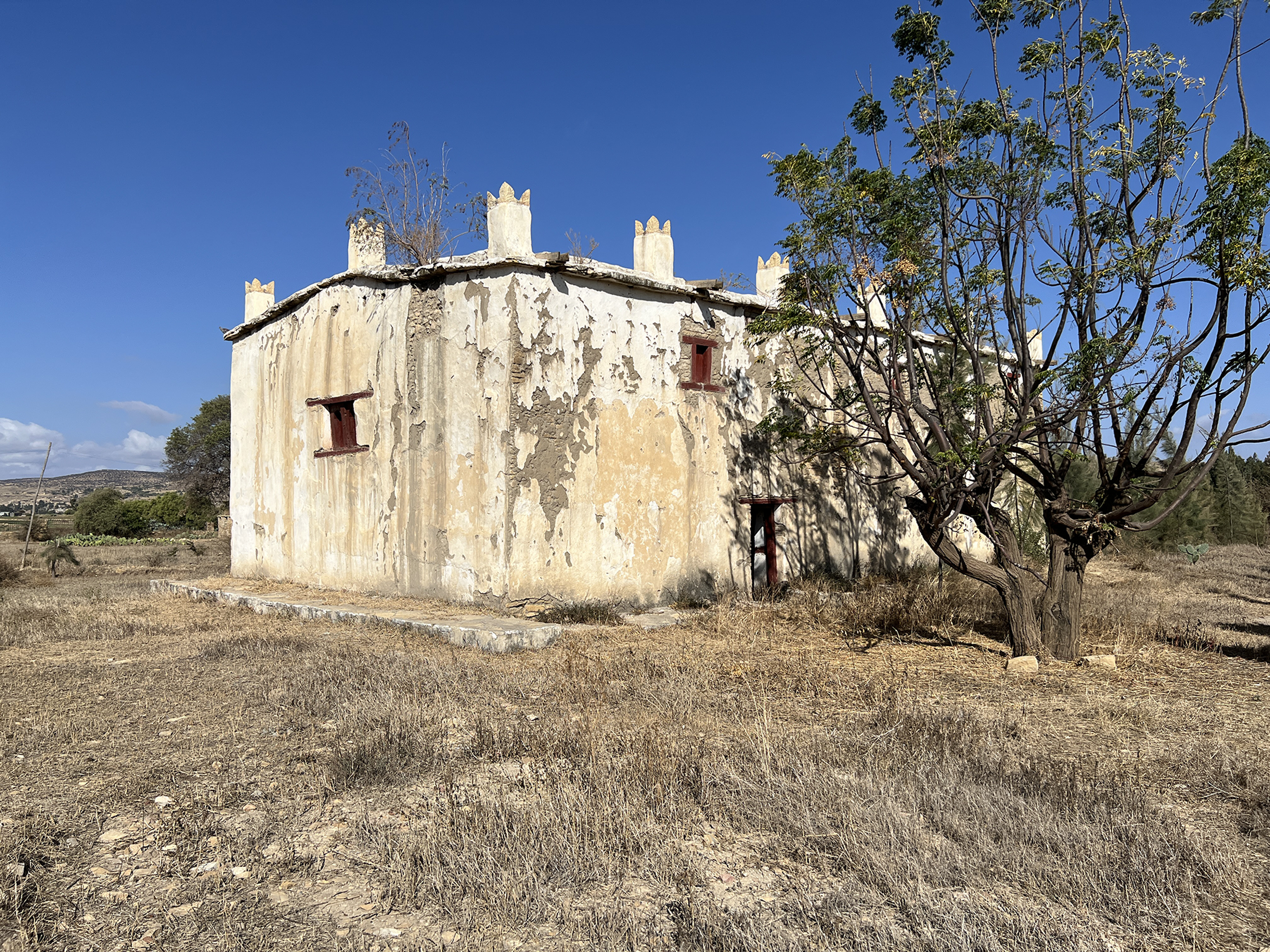
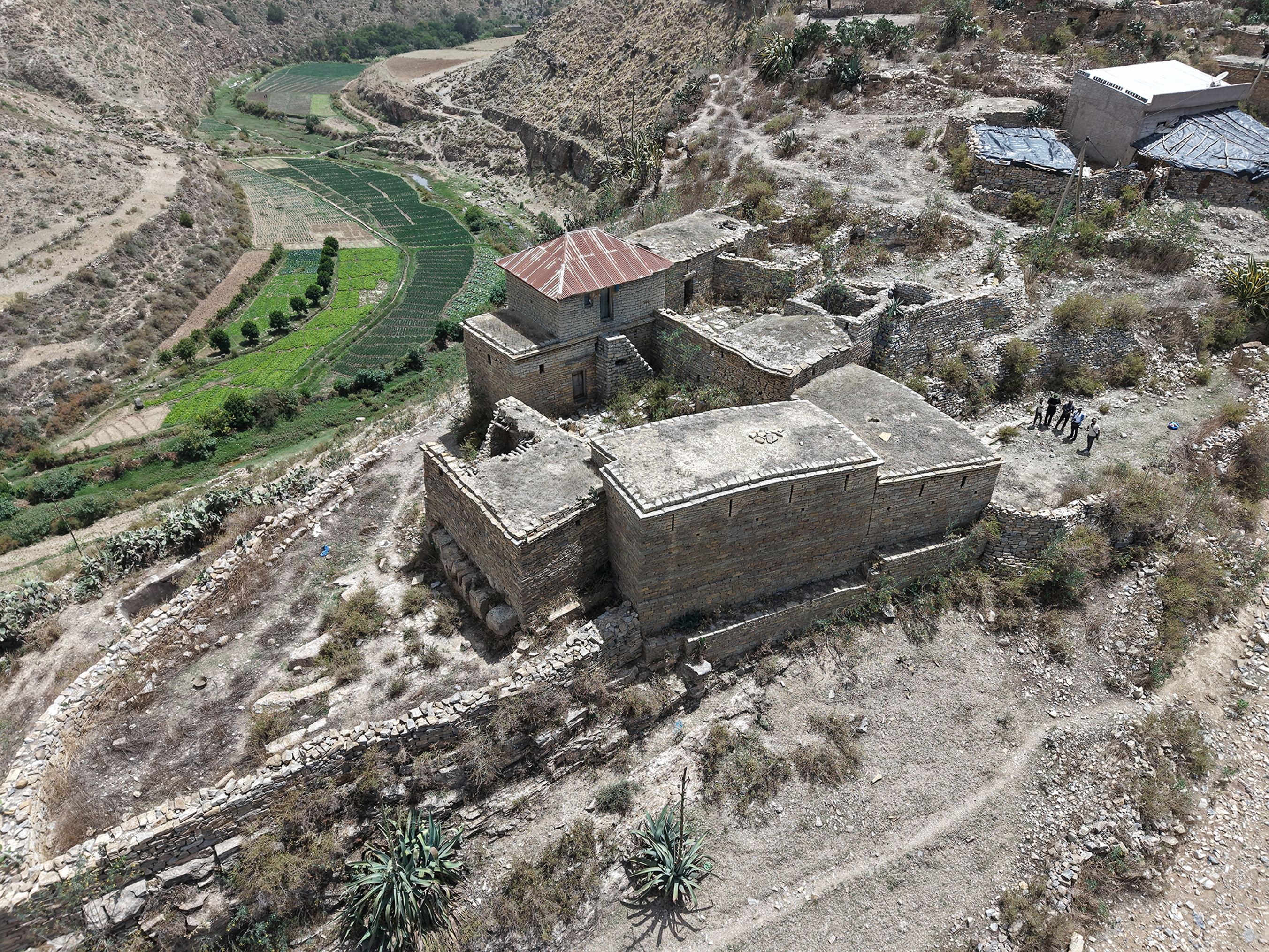
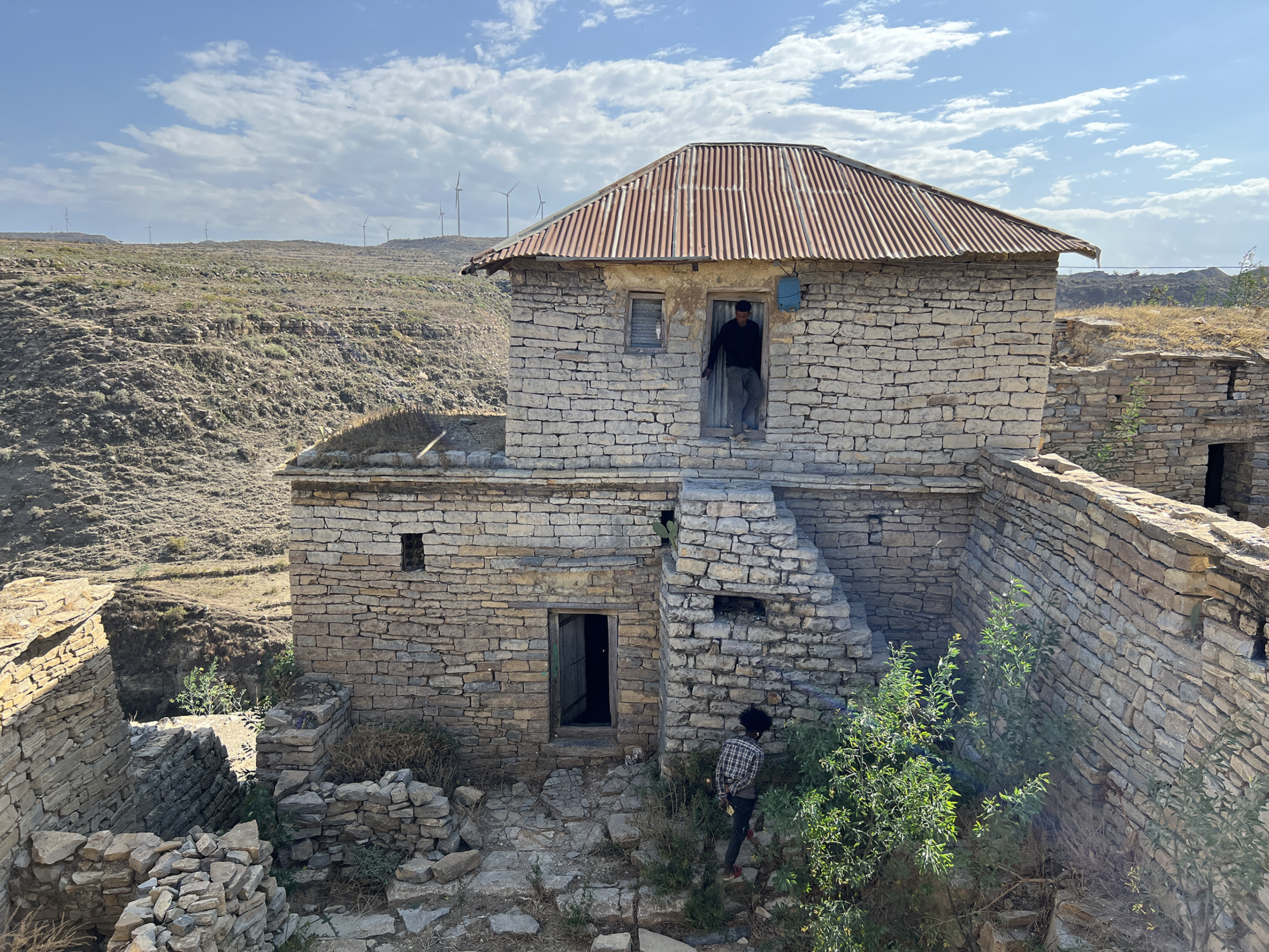
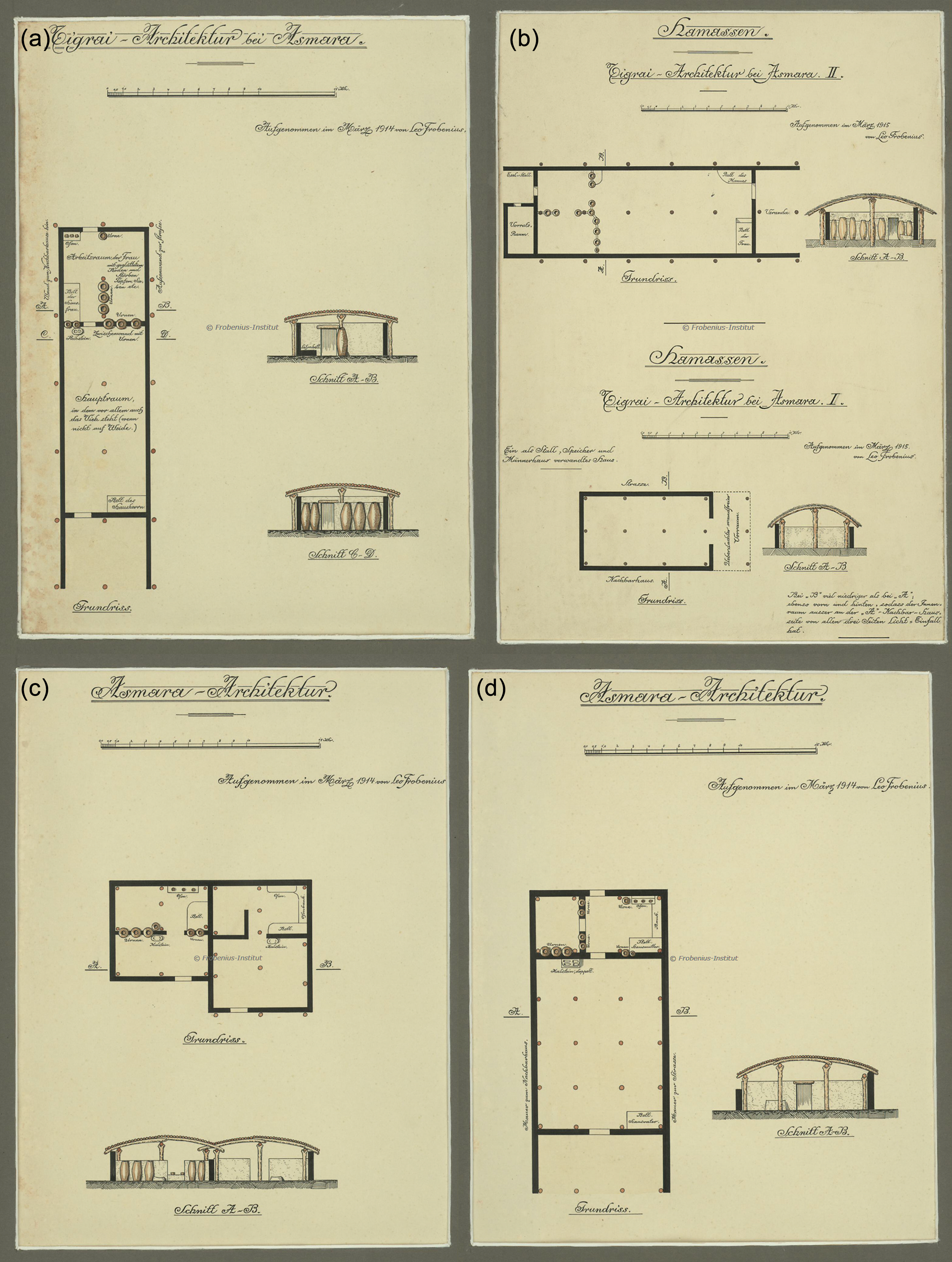
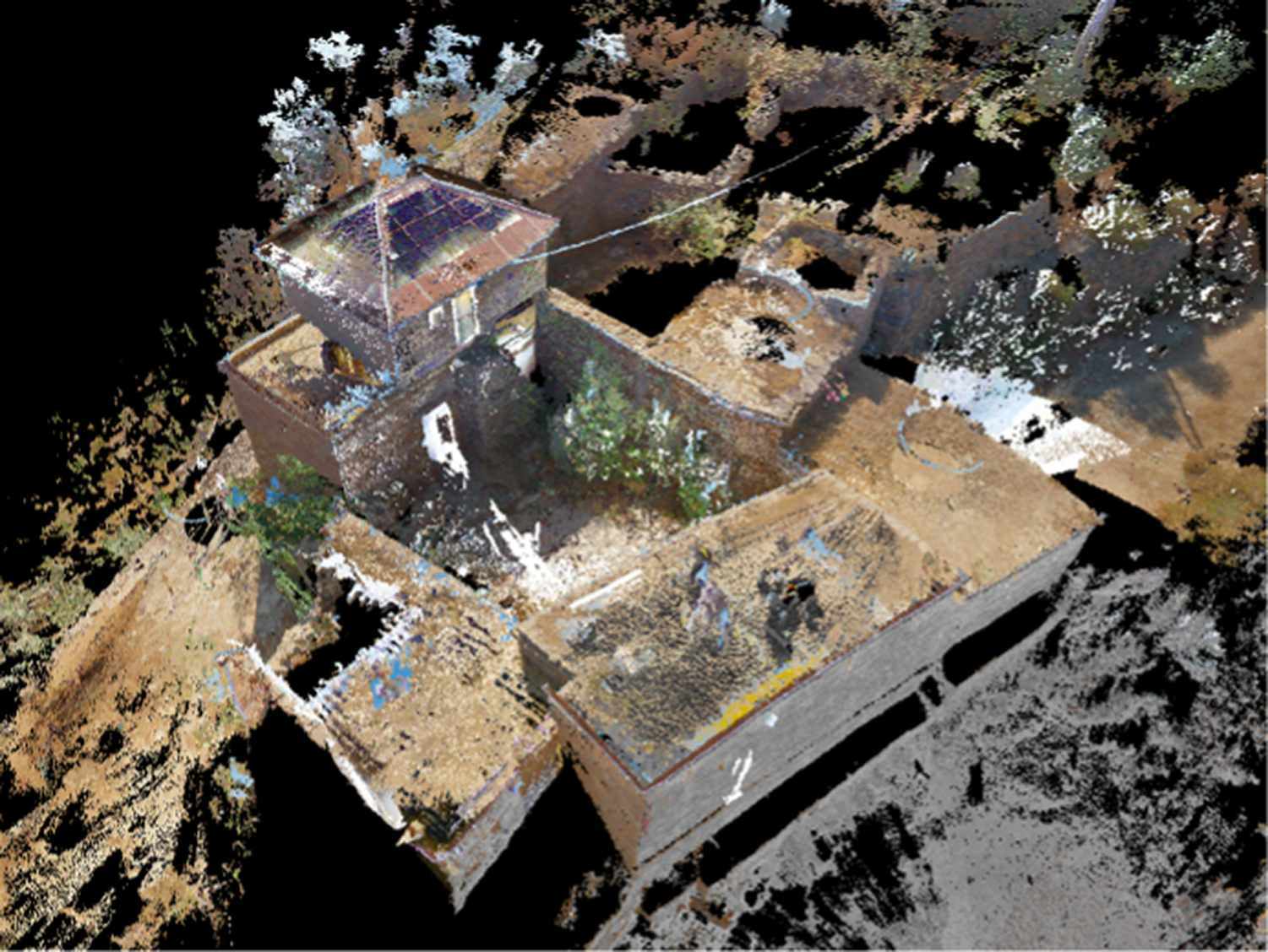
The Kwién Residence exemplifies the hidmo typology, showcasing the traditional masonry and timber construction common in Təgray’s domestic architecture. Situated on moderately sloping terrain, the residence features thick stone walls and a flat soil roof, designed to optimize thermal regulation in the highland climate. Figures 18a and 18b illustrate exterior views of the residence, including its characteristic G+1 configuration. The 3D documentation revealed the layering of construction materials, indicating adaptive reuse, such as the incorporation of salvaged stone from earlier structures. Deterioration patterns, particularly around the roof and openings, underscore vulnerabilities that may lead to collapse, highlighting the need for focused restoration strategies. Figures 19a–19d present historical documentation of similar hidmo structures, taken during the 1913 Frobenius Expedition, offering a valuable reference point for comparative analysis.
Exterior aerial view from the north east, Residence of Riese Debri GebreMaryam in Kwién (2024).

Exterior view of G+1 building, Residence of Riese Debri GebreMaryam in Kwién (2024).

Kwién village, located northeast of Quiha in the Təgray region, is a key site for studying vernacular architecture due to its high concentration of traditional hidmo structures. Situated along the fertile May Enda Estiphanos river, the village historically supported an agricultural economy and served as a minor political centre during the imperial era. Its isolation from major transportation networks has helped preserve its traditional architecture, making it an ideal case study for documentation and analysis amid rapid changes in the region’s heritage landscape. This study focuses on the former residence of Riese Debri GebreMaryam (1900–83), an architecturally significant hidmo, highlighting the role of 3D documentation in the analysis and preservation of vernacular heritage.
To document Riese Debri GebreMaryam’s hidmo, the team used advanced 3D tools to create a detailed digital record of the building. Laser scanning and photogrammetry were used to make clear 3D models, which helped capture the structure’s shape and design. The research team also used an iPhone 13 Pro and an iPad with the Sitescape Pro app to gather point cloud data. While Sitescape made it easy to quickly assess the space and take basic measurements, it had some limitations, including occasional inaccuracies in the data.
The residence’s complex geometry, with its organic layout and integration into the landscape, posed challenges during data acquisition. Laser scanning was essential for capturing these irregularities, while satellite imagery provided a broader context within the village’s topography. 360-degree imaging further enhanced the dataset, aiding in structural assessment.
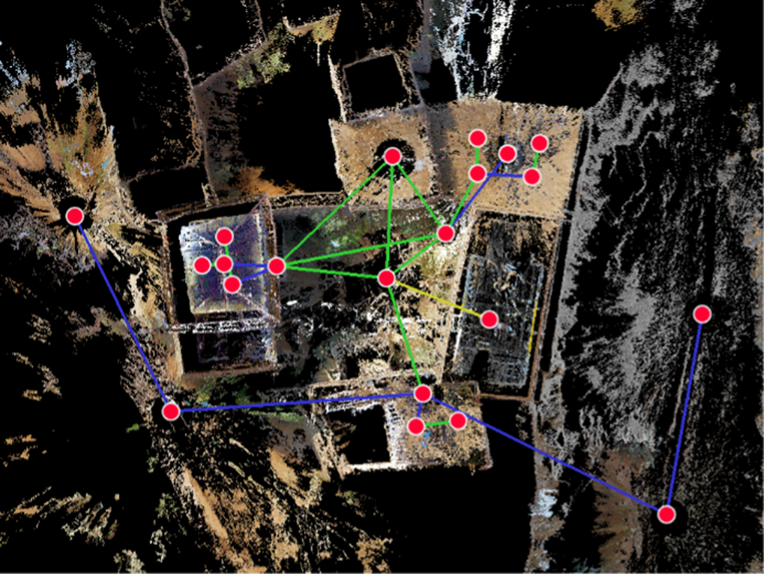
Figures 20a and 20b show the site plan and a perspective view derived from the point cloud dataset, offering insights into the spatial organization and building form. The 3D documentation revealed key architectural and material insights. The point cloud data allowed for precise measurement of the building’s dimensions, structural integrity, and construction methods. Stone masonry analysis showed the use of local basalt and mud mortar, reflecting community-based construction practices. Satellite imagery highlighted the residence’s alignment with environmental factors, such as wind and solar exposure, critical for sustainability. The data also identified areas of deterioration, including foundation erosion and cracks in load-bearing walls, signaling urgent conservation needs.
Documentation of hidmo structures from the Frobenius Expedition, 1913, part of the Ethnographic Picture Archive at the Frobenius Institute, 1915.

Left: Site plan created from point cloud data, Residence of Riese Debri GebreMaryam in Kwién (2024).

Right: Perspective view created from point cloud data, Residence of Riese Debri GebreMaryam in Kwién (2024).

Evaluation of documentation accuracy for the plan of Ch’erqos Wuqro Rock-hewn Church: (a: left) based on Georg Gerster, Churches in Rock, 1970; (b: centre) based on Ruth Plant, Architecture of the Tigre, Ethiopia, 1985; (c: right) Field Survey Data Obtained with Laser Scanner, Team, 2024.

An interview with Ayte Mehari GebreMaryam, the son of Riese Debri GebreMaryam, provided valuable historical and cultural context. He described the construction of the residence, which began in 1944, highlighting the role of skilled local craftsmen and community collaboration. He also explained the socio-political significance of the building during his father’s leadership. This information helped connect the building’s physical features to its historical and cultural functions. As hidmo structures face growing threats from abandonment and environmental degradation, the insights from this advanced documentation are crucial for their preservation.
Discussion
Synergies between archival research and field documentation
The integration of archival research with 3D field documentation is a powerful approach for conserving Təgray’s vernacular architecture. Archival research provides essential historical context and baseline data, which are critical for understanding the evolution of architectural styles, construction methods, and the cultural significance of these structures within their communities. (See Figures 19a–19d and 21a–21c for examples of comparative documentation.)
Complementing archival research, 3D documentation technologies are crucial for capturing detailed spatial information and visual records of Təgray’s vernacular architecture. Techniques like photogrammetry, laser scanning, and drone-based imaging create accurate digital models that document the physical dimensions and intricate details of buildings, enabling precise measurements and spatial analysis. This is illustrated in the architectural outputs from Ch’erqos Church (Figures 9a–10b) and AgulaÊ¿ Castle (Figures 14–17), which highlight the value of point cloud data for conservation.
The synergy between archival research and 3D field documentation allows researchers and conservationists to create detailed inventories of architectural heritage. These inventories are essential for monitoring the condition and deterioration of structures, identifying vulnerable areas, and prioritizing conservation efforts. This combined approach enhances the effectiveness of preservation strategies, ensuring that Təgray’s vernacular architecture is better understood and safeguarded. In the case of the Kwién Residence, this is demonstrated through spatial mapping of deterioration zones and layout planning (Figures 20a and 20b).
Furthermore, this interdisciplinary approach goes beyond preserving physical structures to protect intangible cultural heritage. It includes documenting traditional building techniques, community knowledge, and cultural practices associated with the architecture. By capturing these elements alongside the physical structures, the approach ensures a holistic preservation effort that respects and sustains the cultural identity embedded in Təgray’s vernacular architecture.
In conclusion, the integration of archival research with 3D field documentation offers a strong framework for sustainable conservation in Təgray. By blending historical insights with modern technology, this approach not only preserves architectural heritage but also fosters community involvement and contributes to global heritage preservation efforts.
Challenges and opportunities
This study demonstrates that combining archival research and 3D documentation technologies enhances the preservation of Təgray’s vernacular architecture by bridging historical insights with precise spatial analysis. Archival resources, such as records from the Frobenius Institute, provide detailed historical contexts, including the evolution of hidmo houses and the blending of architectural styles. These insights are vital for interpreting the cultural significance and construction techniques of key sites like Ch’erqos Rock-hewn Church and AgulaÊ¿ Castle. Meanwhile, 3D laser scanning and photogrammetry provided high-resolution spatial data, enabling the creation of accurate digital models, such as those presented in Figures 9b, 14 and 16, which are useful not only for preservation but also for the development of restoration plans.
An additional benefit of 3D documentation is the generation of precise architectural plans and sections, which are invaluable for both archival purposes and future restoration strategies. Point cloud data provides a geometrically accurate framework for in-depth analysis, which is essential for evaluating structural integrity and identifying vulnerable areas. For instance, the point cloud model of the Ch’erqos Rock-hewn Church provided accurate floor plans and cross-sections, establishing a baseline for future comparative studies and restoration. (See Figures 9b and 10a–10b.) It also enables visual presentations for educational purposes, helping to communicate the architectural significance to a broader audience. Similarly, the digital reconstruction of the AgulaÊ¿ Castle offered insights into the original spatial configuration (Figures 14–17), crucial for phased restoration planning. These outcomes show the potential of 3D models to serve as foundational tools for both historical preservation and engineering diagnostics, complementing more invasive structural evaluation methods like material testing or finite element analysis.
Despite its many advantages, the integrated approach faced logistical and technical challenges. The dispersion of archival materials across international repositories limited the ability to compile a comprehensive historical reconstruction. Additionally, the prohibitive costs and specialized expertise required for 3D technologies hindered their widespread application. Furthermore, the remote and rugged terrains of the Təgray region posed challenges during fieldwork. The lack of electricity in certain areas, such as during documentation at Kwién, significantly slowed down the process. (Figures 18a and 18b show the residence documented under these field conditions.) At the Wuqro rock-hewn church, excessive heat caused the Leica laser scanner and the iPad used to operate the scanner to malfunction, highlighting the limitations posed by environmental conditions. Addressing these issues through digitized archives, better access to technology, and localized training in 3D documentation would improve accessibility and expand the applicability of this method.
The case studies demonstrate the potential of this interdisciplinary method in conservation science. For example, the Ch’erqos Church case highlighted how 3D models captured intricate carvings and other architectural details that traditional surveys could not reach. Archival comparisons also revealed historical alterations that had occurred over time. (See Figures 21a–21c for documentation comparison.) Similarly, the documentation of the hidmo’s layered construction phases through 3D technologies showed the value of combining tangible and intangible heritage documentation. These results emphasize the feasibility of this integrated approach as a replicable model for conserving architectural heritage globally.
Conclusion
This study underscores the critical importance of integrating archival research with 3D field documentation technologies in the preservation of Təgray’s vernacular architecture. The region’s architectural heritage is particularly vulnerable due to threats from conflict, environmental degradation, and modernization. As vernacular structures in Təgray continue to change or deteriorate rapidly, active and continuous documentation becomes essential for their long-term preservation. The case studies of Ch’erqos Rock-hewn Church, Kwién Residence, and AgulaÊ¿ Castle illustrate how the combination of archival sources and digital outputs can produce detailed, multi-layered documentation.
Archival research, particularly from institutions such as the Frobenius Institute, provides essential historical context, informing the architectural evolution and cultural significance of these buildings. Archival materials, including architectural drawings, photographs, and field reports, offer a comprehensive framework for understanding construction techniques, material usage, and the socio-cultural importance of these structures. (Figures 19a–19d and 21a–21c serve as illustrative examples.) For example, the study of Ch’erqos Rock-hewn Church revealed insights into the unique rock-hewing techniques used in its construction, critical for developing effective conservation strategies. These historical resources help guide the interpretation and preservation of architectural elements, ensuring that interventions respect the original design integrity.
3D documentation technologies – such as photogrammetry, laser scanning, and drone imaging – offer unparalleled precision in capturing the physical characteristics of these structures. The digital models generated through these technologies enable detailed spatial analysis, precise measurements, and virtual reconstructions. These tools provide a deeper understanding of the buildings’ physical attributes and structural vulnerabilities. As shown in Figures 9a–10b and 14–17, point cloud data allowed the production of plans and sections critical for conservation planning. For instance, in the case of the Kwién Residence, 3D models enabled the identification of areas of deterioration that traditional surveying methods might have missed. The ability to create accurate digital replicas of the buildings aids in planning restoration and conservation interventions with high precision.
The integration of archival research and 3D documentation technologies fosters a dynamic feedback loop, where archival records guide field surveys, and 3D models provide empirical data to verify and expand upon historical narratives. This is particularly evident in the reconstruction of AgulaÊ¿ Castle and the archival comparisons at Ch’erqos (Figures 21a–21c). The AgulaÊ¿ Castle case study demonstrated how combining archival evidence and 3D documentation revealed previously undocumented architectural features, enhancing the understanding of the site’s construction history and its degradation over time. This approach not only improves the accuracy of historical reconstructions but also helps pinpoint areas requiring immediate conservation action.
Furthermore, the democratization of these technologies is crucial for the long-term success of heritage conservation. Ensuring access to advanced documentation tools like 3D scanning and drone-based imaging for local counterparts, including community members and local heritage professionals, enhances the capacity for sustained conservation efforts. Community-based conservation initiatives, such as those seen in Maryam Korkor and Abune Penteleon, have demonstrated that when local communities are empowered with the tools and knowledge to document and conserve heritage, the outcomes are more effective and enduring. Visual platforms, such as 360-degree photo tours (Figures 5 and 8), play a key role in public accessibility and participatory preservation. Therefore, it is essential for archival institutions to make their resources more accessible to local communities, ensuring that valuable historical information is used to inform and guide conservation practices.
Additionally, archives must adapt to the digital age by updating their collections with contemporary documentation outputs. Incorporating data from 3D scans, 360-degree tours, and other modern techniques into archival repositories will not only preserve the evolving digital record of heritage sites but also ensure that these resources remain relevant to current and future conservation efforts. This process ensures that the archive becomes a living document, reflecting the latest understanding of the heritage it seeks to protect.
In conclusion, the integration of archival research and 3D documentation technologies provides a robust framework for the sustainable preservation of Təgray’s vernacular architecture. Given the region’s vulnerable heritage, active and continuous documentation is critical for safeguarding these structures. This approach ensures the comprehensive recording of architectural heritage, while also supporting the development of targeted conservation strategies grounded in both historical insights and modern technological capabilities. The successful application of this methodology in the case studies provides a replicable model for other regions facing similar challenges. Moreover, continued collaboration among heritage experts, technology developers, archivists, and local communities is essential to ensure the long-term success of these preservation initiatives.
Acknowledgments
This research was supported by the Gerda Henkel Foundation and MEXT/JSPS KAKENHI Grant Number JP19KK0114. We thank the Tigray Bureau of Culture and Tourism for their cooperation.
Alula Tesfay Asfha is an architect, academic, and expert in cultural heritage preservation. He holds a PhD in World Cultural Heritage Studies from the University of Tsukuba, Japan (2021), and currently serves as a Gerda Henkel Fellow at the Frobenius Institute, Goethe University Frankfurt. He is also an Assistant Professor at Mekelle University and a World Heritage Advisor for ICOMOS (International Council on Monuments and Sites). Alula has led significant heritage conservation initiatives, including the restoration of the Gunda Gundo Monastery and broader post-conflict heritage recovery efforts in northern Ethiopia. He currently directs two major projects funded by the Gerda Henkel Foundation: the Tigray Heritagescapes Restoration Initiative and the Stabilization of Historical Archives in Mekelle City.
Rumi Okazaki received her PhD from Keio University in 2015. Following her roles as an assistant professor at Keio University, visiting researcher at the Centre National de la Recherche Scientifique (CNRS) in France, she joined the School of Architecture at Shibaura Institute of Technology as an associate professor in 2021. Her specialization is architectural history, with over twenty years of research dedicated to architectural heritage, particularly in Ethiopia. She is a member of ICOMOS Japan, Architectural Institute of Japan (AIJ), and Japan Consortium for International Cooperation in Cultural Heritage (JCIC-Heritage).
Tadesse Girmay is a Heritage Architect, Conservator, Urban Designer/Manager, Construction Quality Supervisor, and Academic with over twenty years of experience in architectural design, heritage conservation, and urban planning. Born and raised in the Tigray region of Ethiopia, he has led and coordinated multiple scientific and World Heritage projects, specializing in conservation, construction supervision, and consultancy. Starting as a junior studio architect, he progressed through senior roles in architecture, academia, and research while mentoring students in architecture, archaeology, planning, and heritage studies. His expertise extends to engaging communities, religious leaders, professionals, policymakers, and diplomats to drive heritage preservation initiatives. Tadesse is recognized for his leadership in integrating heritage conservation with urban development, ensuring sustainable and community-driven approaches.


 Open access

