


Large landscape-scale planning efforts, policies (see Secretarial Orders [SO] 3330 and 3336, and interstate undertakings have brought to the forefront the need for effective and efficient ways to manage and analyze spatial information on archaeological and historic sites for cultural resources management (CRM). Over the past several years, more calls for landscape-level approaches to analyzing the past have been promoted (Altschul Reference Altschul2016; Bureau of Land Management [BLM] 2012; Doelle et al. Reference Doelle, Barker, Cushman, Heilen, Herhahn and Rieth2016; Halford Reference Halford, Baldrica, DeBunch and Fowler2019; Heilen and Altschul Reference Heilen and Altschul2019; McManamon et al. Reference McManamon, Doershuk, Lipe, McCulloch, Polglase, Schlanger, Sebastian, Sullivan and Childs2016; Murtha et al. Reference Murtha, Lawres, Mazurczyk and Brown2019) versus “site-centric” methods, which have been the historic norm in CRM. Site-centric approaches are due, in part, to the fact that CRM has been caught in a sort of “methodological stagnancy” (Halford Reference Halford, Baldrica, DeBunch and Fowler2019:17) applying Section 106–driven, risk adverse, Class III rote inventory (viewed as “complete” inventory) that often lacks comprehensive evaluation of the resources and landscapes upon which they occur. Much of this can be attributed to the frequently rigid procedural application of Section 106 (36 CFR 800), misreading of the purpose, intent, and requirements of the National Historic Preservation Act of 1966 (as amended; [NHPA] Public Law 13-287, 54 U.S.C. §§ 300101-307108), but we believe it is due mainly as a result of the lack of data access and the data quality needed to pursue practical landscape-level approaches.
This article describes the Bureau of Land Management's (BLM) efforts, within the agency, to remedy data access and quality of geospatial data for resources (broadly viewed as recorded archaeological sites) and investigations (the studies that result in resource recordation) through the development of a National Cultural Resources Data Standard (NCRDS; BLM 2019a, 2019b, 2019c; Supplemental Files A–G). Due to the complexity of such an effort, here we only provide an overview of the history and efforts to establish a standard, which in over 20 years of discussion and work has been elusive and only now a realization within BLM. For details, the reader is referred to the supplemental material provided. The supplemental files detail the standard attributes, domains, logical data model, business questions, data transformation procedures, and the platform (NCRIMS) that hosts the data (Supplemental Files A–G).
THE BLM NATIONAL CULTURAL RESOURCES MANAGEMENT DATA STANDARD (NCRDS)
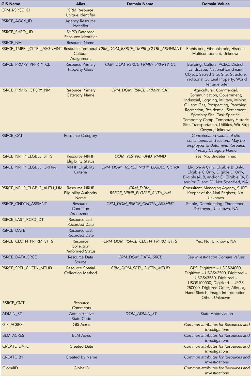
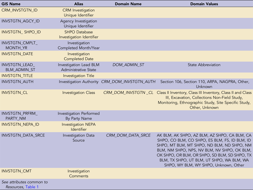
The BLM Headquarters Division of Education, Cultural and Paleontological Resources (HQ-420, previously WO-240), in conjunction with BLM State Offices, determined there was a need for an enterprise solution to managing cultural heritage data for project and landscape-level planning within the organization. An enterprise solution provides cultural heritage data standardization and consistency across the Bureau. The need for a national-level cultural resources database has long been recognized by BLM and other agencies (such as the National Park Service [NPS], United States Forest Service, State Historic Preservation Offices [SHPO], etc.) to facilitate normalization of common attributes for analytical applications to support planning decisions and preservation (Altschul Reference Altschul2016; Heilen and Altschul Reference Heilen and Altschul2019; Ingbar et al. Reference Ingbar, Hopkins and Seaman2000; McManamon et al. Reference McManamon, Doershuk, Lipe, McCulloch, Polglase, Schlanger, Sebastian, Sullivan and Childs2016: Murtha et al. Reference Murtha, Lawres, Mazurczyk and Brown2019). In 2015, after many years of development of an initial data standard (see history below), two pilot projects were undertaken to test the applicability and usefulness of the standard—first on a small scale in the Four Corners area within the Colorado Plateau Rapid Ecoregional Assessment zone (established to identify important resource values and patterns of environmental change: https://landscape.blm.gov/geoportal/catalog/REAs/REAs.page), and subsequently, in the BLM western states. Following the proof of concept, as tested by these pilots, in 2018 BLM formally implemented the NRCDS as codified in “WO-IM-2018-079” (see BLM 2019a, 2019b, 2019c; Supplemental Files A–G), building a standardized GIS database of cultural resources and investigations. Tables 1 and 2 show the attributes, domains, and domain values of the resource and investigation feature classes (for more detail refer to Supplemental Files A–E).
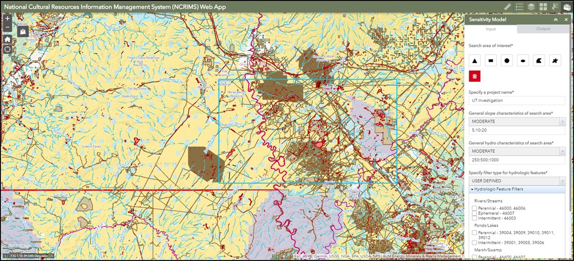
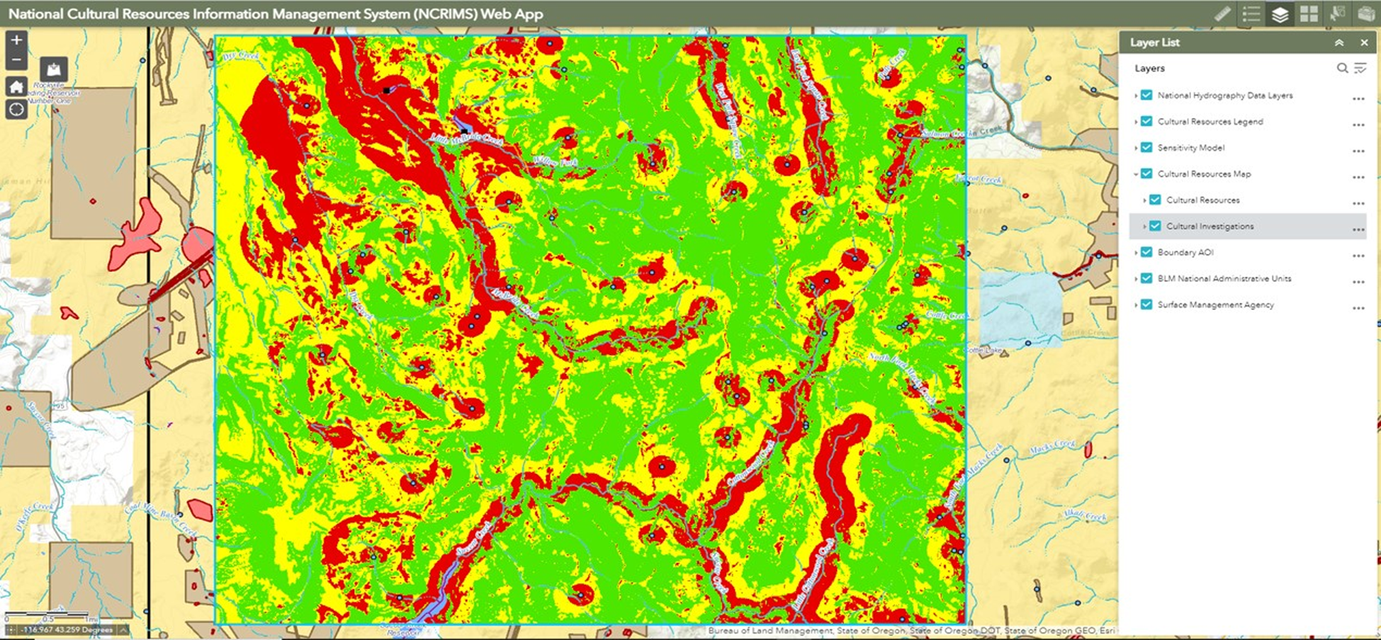
To date, the database contains roughly 470,000 resources and 195,000 investigations (as shown in Figure 1, along with each feature class attribute table). The data are maintained as polygon features in an Esri file geodatabase (FGDB) at the BLM National Operations Center (NOC) located in Denver, Colorado. The database is currently updated annually with data drawn from 11 western states (AK, AZ, CA, CO, ID, MT, NM, NV, OR, UT, and WY). The data are hosted and accessible in the National Cultural Resources Information Management System (NCRIMS) Web Application (WebApp; Figure 2), maintained on the NOC EGIS web platform. Figure 2 shows the data displayed in the WebApp interface and the sensitivity model menu (see Supplemental File G for full details on the application and modeling tool). NCRIMS contains the NCRDS dataset as well as the Cultural Heritage Resource Sensitivity Model (CHRSM). The CHRSM allows for a high-level analysis of the data with an associated output report and data (Figure 3; National Cultural Resources Information Management System [NCRIMS] 2020 [Supplemental File G]).
BLM National Resource and Investigations data and NRCDS attributes.
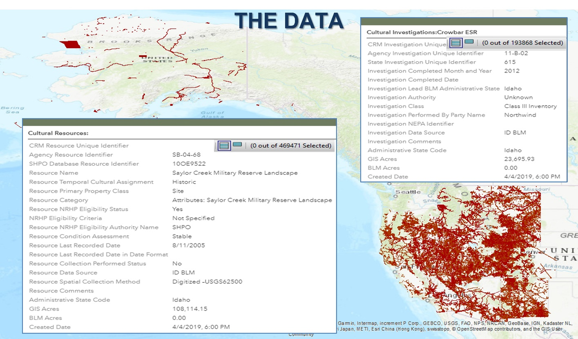
NCRIMS WebApp and CHRSM toolbar (sites in red, investigations in brown).
NCRIMS WebApp, CHRSM output (Green = Low, Yellow = Moderate, Red = High probability for resource occurrence).
The NRCDS is designed to capture core attributes that are common identifiers and information about a resource or investigation, such as the site identifier, site type, eligibility, condition, class of inventory, acres, etc. (Tables 1 and 2). These are core fields—agreed upon between the western SHPOs and BLM—that any agency and data manager, regardless of geography, need as primary attributes to provide the key information and metadata about a resource or investigation. The standard is not designed to capture all information about a resource or investigation but instead serves as the GIS component of an analysis to answer primary business questions and address landscape analysis needs for local and regional planning, multistate regional analysis, and high-level modeling—as well as to inform national-level cultural heritage resource management questions and concerns. In essence, it provides a snapshot view of a resource or investigation to give the user essential primary information, in addition to providing core components of data and metadata necessary in modeling applications. It is designed to not be overly complicated, facilitating data population and maintenance by fitting into the day-to-day business needs and work routine of the CRM specialist.
A comprehensive BLM-wide GIS of cultural resource locations and investigations creates significant workflow and data management efficiencies, realized in time and cost savings and providing an important tool for all aspects of CRM and historic preservation. The NCRDS dataset employs standardized and normalized basic content data and feature-level metadata, allowing general characterization of types and number of resources for planning and analysis on an inter- and intrastate level. The landscape-level datasets and CHRSM reports allow the cultural heritage program to engage in discussions early in the planning process versus at the late stages, as has been traditional. Instead of a “clearance-focused” management orientation, we can assess and evaluate cultural heritage values with the “best science” and allow constituent participation early to inform outcomes. NCRIMS is the platform that hosts the NCRDS and CHRSM, and going forward, it will be applied as the acronym describing these three inclusive facets of the data system (see Supplemental File G).
DEVELOPMENT: HISTORY AND EVOLUTION
The need for standardized cultural data has a long history as detailed here and in an earlier BLM report by Clark and Ingbar (Reference Clark and Ingbar2005). The core issues and challenges identified have not changed over the years and are reiterated by more recent discussions (Altschul Reference Altschul2016; BLM 2012; Doelle et al. Reference Doelle, Barker, Cushman, Heilen, Herhahn and Rieth2016; Halford Reference Halford, Baldrica, DeBunch and Fowler2019; Heilen and Altschul Reference Heilen and Altschul2019; McCarthy Reference McCarthy2009; McManamon et al. Reference McManamon, Doershuk, Lipe, McCulloch, Polglase, Schlanger, Sebastian, Sullivan and Childs2016: Murtha et al. Reference Murtha, Lawres, Mazurczyk and Brown2019), and the reader is referred to their (Clark and Ingbar Reference Clark and Ingbar2005) report for a comprehensive treatment. As elucidated by Clark and Ingbar (Reference Clark and Ingbar2005), we have been at the business of finding data management solutions for a long time. As noted by Clark and Ingbar, as far back as
the 1920s, Frank Mera established a system of mapping and keeping notes on all archaeological sites in New Mexico at the Laboratory of Anthropology. . . . In the mid-1970s the Southwest Anthropological Research Group (a coalition of researchers) created an explicitly computerized format for the SARG Database: a systematic set of observations to be made on every archaeological site. . . . In the late 1970s, regional recording formats for archaeological sites and rock art grew out of this broader interest in site distribution and contents. The Intermountain Antiquities Computer System (IMACS) recording form was devised to be entered into a database [Reference Clark and Ingbar2005:3].
As the influx of data increased substantially after the passage of the NHPA in 1966, archive and data management issues continued to evolve. By the 1980s, groups such as the Cultural Resource Information Managers Exchange (CRIME) were formed to address archive and standardization issues (Clark and Ingbar Reference Clark and Ingbar2005). As GIS platforms evolved in the following decade, efforts moved to apply GIS as a data management solution for cultural resources. As noted by Clark and Ingbar (Reference Clark and Ingbar2005:3), in 1993, Ebert and Associates investigated the automation of archives nationally under a grant from the National Science Foundation (NSF) and their study confirmed that most archives in the western United States would move toward database management and GIS (see also Ebert et al. Reference Ebert, Ingbar and Camilli1994). In the mid-1990s, the National Spatial Data Infrastructure was established by executive order, and the Federal Geographic Data Committee (FGDC) was created to set data and metadata standards for federal agencies. In 2000, Ingbar et alia reported on a synthesis prepared under a FGDC grant to create metadata standards specific to CRM datasets. They came to these conclusions:
(1) Federal agencies use state-determined record formats because of the need to collaborate with SHPOs in each state.
(2) There is considerable variation between states (except for IMACS states) in site recording standards and report standards.
(3) The work process itself was generally common from one state to the next.
(4) Notwithstanding state-level variation, there is a high-level set of attributes that all participants in the work process agreed are either mandatory, mandatory if present, or strongly recommended (Ingbar et al. Reference Ingbar, Hopkins and Seaman2000).
In 2002, the Office of Management and Budget (OMB) released revised Circular A-16 (OMB A-16). The purpose of OMB A-16 is to improve coordination among federal agencies in creation of geographic and spatial data. It establishes the FGDC as the coordinating body in support of the National Spatial Data Infrastructure (NSDI). The NPS was assigned the task of taking the lead in facilitating the creation of cultural resources data standards through FGDC procedures. In 2009, an interagency meeting was convened in Washington, DC (McCarthy Reference McCarthy2009) to develop a data transfer standard between federal, state, and tribal agencies. A working group has been collaborating on a standard since that time. To date, this standard has not been completed, underscoring the difficulty of standards development. This is mainly due to the myriad of participants with established yet disparate data systems and database structures. Murtha and colleagues (Reference Murtha, Lawres, Mazurczyk and Brown2019) note the challenges in their comparison of two states, Florida and Pennsylvania, showing their inconsistencies. Extrapolate that 100- fold to include all states, federal agencies, Tribes, and other partners, and one begins to understand the challenges.
THE GENESIS OF THE NCRDS
In 1997 (as amended in 2012), BLM entered into a national Programmatic Agreement (nPA) with the Advisory Council on Historic Preservation and the National Conference of State Historic Preservation Officers. As a result of the earlier data management efforts, an agreement component in the nPA includes the
analysis and synthesis of data accumulated through decades of Section 106 compliance; historic property identification where information is needed, not just in reaction to proposed undertakings; long-term preservation planning; planning-and priority-based historic resource management; data sharing, including information resource management development [nPA 2012]
addressing the “backlog of un-synthesized site location and report information, and data quality improvement.”
Pursuant to the nPA, to enhance data management and sharing, in 1998, the BLM established the Data Users Group (DUG), chaired by a BLM coordinator, which organizes and works with BLM and SHPO data representatives from each of the 11 western BLM states where the majority of BLM-administered public lands are located. In 2006, the team was rechartered as the Cultural Resources Data Sharing Partnership (CRDSP, today known as the CRDP). The business model is to support the SHPOs in their task under Section 101(3)(A) of the NHPA to “conduct a comprehensive statewide survey of historic properties and maintain inventories of such properties.” The ultimate goal was to establish data management systems that meet both the SHPO and BLM missions, with investments directed to support SHPO systems. Over the 24-year history of the CRDP, BLM has invested over $8 million in the initiative, providing yearly funding to the 11 western SHPOs, which continues to this day.
Following the early data management initiatives, as described previously, an effort to establish consistency across state platforms has been pursued since the start of the partnership (Clark and Ingbar Reference Clark and Ingbar2005; Ingbar et al. Reference Ingbar, Hopkins and Seaman2000; McCarthy Reference McCarthy2009). At a CRDSP meeting in Portland, Oregon, in 2007, the members voted and agreed to adopt a data content standard, outlining core attributes that address primary business needs, to ensure consistency across the states to facilitate data management, data transfer, and analytical applications on an interstate level. As discussed, the content standard included the primary information that all states require regarding a resource or investigation and as captured in the BLM NRCDS (Tables 1 and 2). However, prior to the development of NCRIMS, there had been many challenges and little success in creating consistency and normalcy across state boundaries; many have acknowledged the tall hurdles to doing so (see Advisory Council on Historic Preservation 2020; Murtha et al. Reference Murtha, Lawres, Mazurczyk and Brown2019; Wilshusen et al. Reference Wilshusen, Heilen, Catts, de Dufour and Jones2016). As a result, due to data management and access needs—in addition to creating workflow, planning and analysis efficiencies, and enhanced preservation—BLM determined to leverage the many years of standards work to stand up NCRIMS. BLM's NCRIMS standard is essentially the baseline agreed to by BLM's SHPO partners in 2007, with minor modifications and enhancements (Tables 1 and 2; Supplemental Files A–E).
THE COMMUNITY
Any effort of this nature requires a community of CRM practitioners with data management expertise and other stakeholders—such as SHPOs, GIS specialists, and managers—to ensure success. The SHPO and BLM data systems from which the information is harvested, and the communities represented, are complicated and diverse. The CRDP community hosts the data systems, and as described previously, though efforts to create interstate standards have been made, these systems remain incongruent. This is due, in part, to the fact that the treatment of data requires many levels of expertise and support systems, including CRM specialists and GIS specialists, database and web application experts, and beyond—resources that SHPOs may not have access to or funding to support.
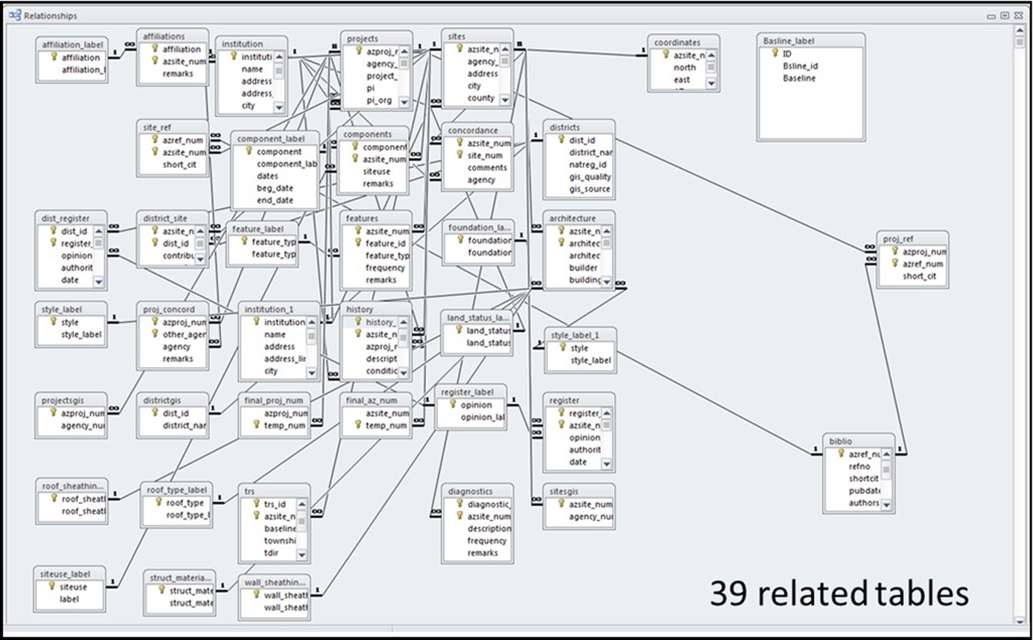
The diverse data must be captured by applying sophisticated Python scripts prepared to perform the extraction, transformation, and upload (ETL) procedures. Given that each state's datasets and management practices differ, ETL scripts must be individually written and maintained for each state. Figure 4 shows the schema of the AZSITE (https://statemuseum.arizona.edu/crm/azsite) database with its 39 related tables, illustrating the complexity. Loading the data into NCRIMS requires involved and often complicated crosswalks that must address data structure changes as they occur at the state level. The data treatment requires subject matter expertise to filter and interpret the data, and GIS expertise to develop the scripts and conduct the ETL procedures (see Supplemental File F for ETL documentation for each state).
AZSITE relational database.
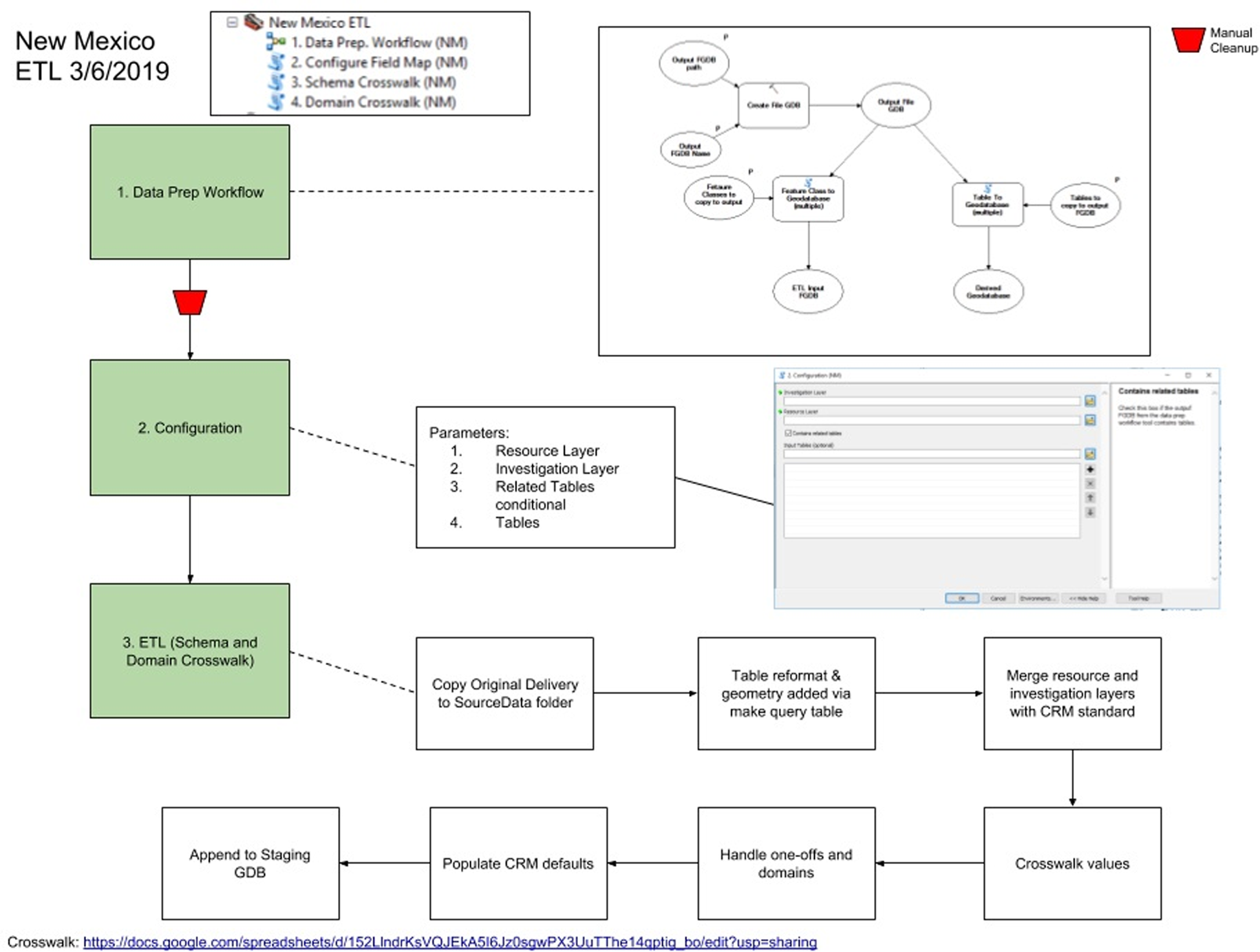
As discussed, a major component—and the greatest challenge—for standing up NCRIMS is data acquisition and performing the ETL from each state's database(s), requiring the state-specific scripts to be automated to transform each state's data. An example schema for New Mexico is shown in Figure 5. Crosswalks are used to map the input state schema to the output CRM dataset and a script tool employed to perform the migration employing Esri's ArcGIS ArcToolbox (Supplemental File F). A toolbox applicable to each state has been configured. The tool(s) include options to configure the schema crosswalk, configure the domain crosswalks, and perform the migration. All crosswalks produced as output from this tool are populated in ArcMap. Additionally, the tool references the Python 2.7 library included with the ArcGIS Desktop installation (see Supplemental File F).
Example of ETL Tool and schema for New Mexico.
THE DATA AND THE VISION
The vision is to create a platform that provides ease of access to standardized and normalized data and associated planning and analysis tools for qualified and credentialed users. As discussed, this facilitates consideration of cultural heritage values at the earliest phases of the planning and Section 106 process as well as real-time access to data in emergency situations to allow better protection of cultural heritage resources and values. Similar efforts include applications such as the Digital Index of North American Archaeology (DINAA; Anderson et al. Reference Anderson, Bissett, Yerka, Wells, Kansa, Kansa, Myers, Carl DeMuth and White2017). DINAA employs an ontological matching scheme to extract high-level site information (such as site chronology) for analytical application, and it has been applied on the Atlantic coast of the United States in efforts to predict coastal flooding impacts to cultural resources that may be caused by global warming. On an archival front, the Digital Archaeological Record (tDAR) was established to address data accessibility and preservation. tDAR is an international digital repository for the digital records of archaeological investigations, often known as gray literature (McManamon et al. Reference McManamon, Kintigh, Ellison and Brin2017). The overarching goal is the “long-term preservation of irreplaceable archaeological data and to broadening the access to these data” (tDAR, https://core.tdar.org/). In a similar manner, NCRIMS provides standardized, normalized, and easily accessible cultural resources spatial data from across the West to the BLM CRM, management, and GIS community. Currently, only qualified users within BLM have access to the data. However, Tribes, consultants, SHPOs, and other vetted partners can work with field, district, and state offices to gain data access on a case-by-case basis.
In the future, NCRIMS could be expanded to interface with an online permitting system and museum databases such as the Department of the Interior's (DOI) online Museum Collections Management System (under development). With the use of platforms such as ArcGIS Online (AGOL), ArcGIS Enterprise, and mobile apps, such as Collector/Field Maps/Survey123 (www.esri.com), data can be collected in real time in the field and synced to the NCRIMS master database. This workflow would save substantial time, reduce costs and errors, negate the need to perform ETL procedures, and eliminate the significant redundancy that occurs in CRM data management.
THE PLATFORM: NATIONAL CULTURAL RESOURCES INFORMATION MANAGEMENT SYSTEM (NCRIMS) WEB APPLICATION (WEBAPP)
The NCRIMS WebApp provides a web-based interface as shown in Figures 1–3 (see Supplemental File G), hosted on BLM's NOC EGIS platform, that facilitates access to cultural heritage spatial information by CRM specialists, managers, law enforcement personnel, and others who need to know. The data and access to NCRIMS are maintained behind the BLM firewall on an ArcGIS Enterprise server, and only users approved and assigned to the Active Directory user group may gain access. The Active Directory is managed and maintained by the NCRIMS business manager at BLM HQ, who verifies credentials and monitors use statistics.
The underlying CHRSM tool is an implementation of sensitivity analysis, which is informed by many years of modeling across the West (see Barker Reference Barker, Sebastian and Lipe2009; Hall and Ingbar Reference Hall and Ingbar2014; Hall et al. Reference Hall, Drews, Ingbar, Parrish and Noll2013, Reference Hall, Drews, Ingbar and Kirk Halford2015; Heilen Reference Heilen2020; Ingbar and Halford Reference Ingbar and Kirk Halford2008; Ingbar and Wriston Reference Ingbar and Wriston2017; Sebastian et al. Reference Sebastian, Altschul, Rohe, Thompson and Hayden2005, Reference Ingbar, Wriston and Kirk Halford2016; Thomas Reference Thomas and Clarke1972; Wescott et al. Reference Wescott, Abplanalp, Brown, Cantwell, Dicks, Fredericks and Krall2016; Zeanah et al. Reference Zeanah, Ingbar, Elston and Zeier2004). The sensitivity values for the WebApp are based on two common variables—Distance-to-Water and Slope—that are statistically correlated to resource locations. The basic principle is that flat areas close to water were more suitable and desirable for use than steep areas far from water. Empirical site location data, statistics, and field tests bear this out. The model has three default parameter options designed to allow users to cater analyses to a particular landscape condition. Further customization is achieved by the capability to input user-defined parameters. This level of functionality increases the accuracy and usability of the WebApp in a variety of localized environmental and cultural conditions. Data sources include the National Hydrologic Dataset (NHD Plus V2.10 Hydrologic Dataset; http://www.epa.gov/waters), applying the f-code attribute (e.g., perennial, intermittent, ephemeral, marsh, playa, etc.) for calculating distance to water, and the National Elevation Dataset digital elevation model (https://www.usgs.gov/programs/national-geospatial-program/national-map) for calculating slope degrees (see Supplemental File G for details).
The general methodology derives from documented archaeological data that suggest that prehistoric peoples used the landscape in predictable, nonrandom ways based on their knowledge of the geographic distribution of resources. This exploratory framework was used to investigate associations between various environmental variables with known cultural site locations to enable BLM users to (a) understand how prehistoric peoples used landscape features and resources through time, and (b) focus limited resources on areas that have the highest likelihood of yielding significant sites (Ingbar and Wriston Reference Ingbar and Wriston2017; NCRIMS 2020 [Supplement G]). The output report generated by the WebApp provides the numbers, classes, and acreages of investigations as well as numbers, types, and eligibility of resources within the area of interest.
In this manner, NCRIMS can be applied as a high-level planning tool to inform decision-making at the earliest stages of the planning process. An example application would be in travel management planning, where routes could be designed to avoid high-sensitivity areas. Such a proactive approach reduces risk and can save significant time and cost during initial project scoping and analysis and Section 106 application by providing the data and associated tools for determining the level of survey and areas of high sensitivity conducive to targeted investigations. Additionally, NCRIMS output data can be used to facilitate early and proactive consultation with Native American Tribes, consulting parties, and other partners and stakeholders to ensure that concerns related to cultural resources are appropriately addressed during analysis under both Section 106 and the National Environmental Policy Act (NEPA).
The application has ever-increasing success stories, especially as applied during multistate NEPA or planning analyses, such as planning for fuels treatments crossing state boundaries in Idaho and Oregon. It was employed during its testing phase in the San Luis Valley of Colorado for proposed solar siting (Wescott at al. Reference Wescott, Abplanalp, Brown, Cantwell, Dicks, Fredericks and Krall2016), with the comment that it “literally saved days” that would have been required to access and normalize disparate datasets. NCRIMS provided essential data to address a Washington (DC) Headquarters’ data call requesting information about resources and investigations conducted along the southern border. All these analyses were completed within an hour as opposed to the hours or days normally required to access different states’ datasets and standardize them for statistical analyses.
CONCLUSIONS AND THE FUTURE
Cultural resources are a fragile, limited, and irreplaceable part of our nation's heritage. The BLM works continually to develop and improve methods to protect these valuable resources against impairment, destruction, and inadvertent loss while encouraging and accommodating the uses determined appropriate through planning and public participation. One direct outcome of this has been the implementation of NCRIMS on BLM-administered lands to meet business and reporting needs. The NCRIMS WebApp enables BLM users to efficiently conduct landscape-level suitability analyses for planning purposes. NCRIMS utilizes predictive modeling to incorporate expert knowledge and environmental or evidentiary data for identifying areas of cultural resources to inform management decisions that support prudent planning and protection. It creates data collection consistencies and significant cost savings in data management, reducing the obvious and rampant data redundancies that have been the historical norm. Instead of 11 states with numerous field offices “going their own way,” there is now consistency for how data are collected and managed. Of course, there is still work to be done, but NCRIMS is an important and critical step forward in good data management that supports improved analytical capabilities.
NCRIMS hosts standardized geospatial data from all western BLM states that not only informs and facilitates Section 106 analyses at the earliest stages of an undertaking but also supports preservation by reducing project and planning-level conflicts and potential impacts. It enables a shift from site-centric archaeology to landscape-level analyses and promotes more thoughtful approaches to how the agency addresses cultural heritage resources, making their evaluation a forethought and not an afterthought, as has been traditional. Most importantly, NCRIMS gives CRM practitioners, decision-makers, planners, Tribes, and other consulting and interested parties an important view into the number and complexity of cultural heritage values known on public lands and the investigations that are associated with the recordation of the resources. It allows early-stage planning of projects to be aware of—if not fully avoid—areas of high cultural sensitivity. In terms of historic preservation and fulfilling the BLM's many obligations under statute, regulation, Executive-Secretarial Orders, and policy, NCRIMS provides the necessary data synthesis to address and better protect our cultural heritage more effectively for current and future generations.
Through the implementation of NCRIMS, it has become ever clearer that data management is often complicated and sometimes messy. NCRIMS is an example of a sophisticated yet simplistic solution that reflects common goals and shared visions of providing good data and effective tools for CRM pursuits. The platform shows how disparate and diverse data can be standardized and normalized to create a powerful planning tool to enhance historic preservation. For interested parties, there is extensive documentation of the data standard, domains, and business rules (BLM 2019a, 2019b, 2019c; Supplemental Files A–G) that provide an example and road map for future efforts toward standardization of CRM data. Our recommendation is that the substantive work completed be used as a foundation and springboard for similar efforts in cultural heritage resources data standardization.
Acknowledgments
This article is dedicated to the memory of Marilyn Nichols, whose vision and leadership as the BLM Cultural Program Division Chief in the late 1990s–early 2000s led the BLM CRM program down the path of the nPA and many years of partnering with SHPOs in the endeavor of enhanced cultural resources data management; and to Eric Ingbar, who has been engaged in database and standards development for over 30 years, and whose work and collaboration with BLM over many years set the foundation for the NRCDS and other data systems across the West. The authors also wish to thank him for early review and comments on the manuscript.
Funding Statement
All work was funded by the Department of Interior, Bureau of Land Management. Funding for Gold Open Access publication was generously provided by the Arizona Army National Guard.
Data Availability Statement
All data are available in the main text or the supplemental materials. For complete documentation of the data standard, domains, logical data model, business rules and extra, transform and load scripts, contact the Bureau of Land Management, HQ-420, Division of Education, Cultural, and Paleontological Resources, 301 Dinosaur Trail, Santa Fe, New Mexico 87508.
Competing Interests
The authors declare none.
Supplemental Material
For supplemental material accompanying this article, visit https://doi.org/10.1017/aap.2022.39.
Supplemental File A. CRM_Implementation_Guidelines.
Supplemental File B. CRM_Data_Standard_Report.
Supplemental File C. CRM_Domains.
Supplemental File D. CRM_Business_Rules.
Supplemental File E. CRM_Logical_Data_Model.
Supplemental File F. BLM NHS_Data_Conversion_Document.
Supplemental File G. BLM CRM NCRIMS User Manual.


 Open access