


Introduction
On 22 October 1522, a powerful earthquake (magnitude 5.7–6.7) struck the island of São Miguel in the Azores archipelago (Carmo et al., Reference Carmo, Madeira, Hipólito and Ferreira2013). Intense seismic shaking collapsed buildings over a wide area and triggered a major landslide in the hills above Vila Franca do Campo (Figure 1), the earliest and most important colonial settlement on the island. An estimated 3000 to 5000 lives were lost when a flow of mud and boulders swept through the coastal settlement and out into the sea; the event is still regarded as one of the most damaging natural disasters in European history.
Above: location of the Azores (red dot) and São Miguel Island on the triple junction between the North American (NA), Eurasian (Eu) and Nubian (Nu) tectonic plates. Main structures: Mid-Atlantic Ridge (MAR), Gloria Fault (GF), East Azores Fracture Zone (EAFZ) and Terceira Rift (TR). Below: volcanic systems on São Miguel Island with the location of Vila Franca do Campo and other places mentioned in the text. Figure by Melanie Froude and Alejandra Gutiérrez. Map adapted from Madeira et al., Reference Madeira, da Silveira, Hipólito, Carmo, Gaspar, Guest, Duncan, Barriga and Chester2015 and Trippanera et al., Reference Trippanera, Porreca, Ruch, Pimentel, Acocella and Pacheco2014. World topography from NASA, 2018, bathymetry from NOAA, 2018, elevation from ALOS, 2018.

Most of what is known about medieval and early modern tectonic hazards and secondary hazards like landslides has been reported by historians and earth scientists (for an overview, see Guidoboni & Comastri, Reference Guidoboni and Comastri2005; Ambraseys, Reference Ambraseys2009). Only a few field investigations for this period have had a specific archaeological focus (e.g. earthquakes at Basel in Switzerland in ad 1356: Fäh et al., Reference Fäh, Gisler, Jaggi, Kaestli, Lutz and Masciadri2009; Dyrrachium in Albania in ad 1270: Santoro & Hoti, Reference Santoro, Hoti, Përzhita, Gjipali, Hoxha and Muka2014; landslides at Onoldswil in Switzerland in ad 1295: Akeret et al., Reference Akeret, Kiefer, Kühn, Rentzel, Rösch and Wick2018; volcanic eruptions and the ad 1343 Stromboli eruption: Rosi et al., Reference Rosi, Levi, Pistolesi, Bertagnini, Brunelli and Cannavò2019). These projects typically reconstruct events at a local or landscape scale and assess their magnitude or intensity, documenting loss of life and infrastructure, analysing destruction deposits, and recording evidence for both community preparedness and disaster recovery. Even so, a detailed understanding of impact on the ground can be lacking (Ambraseys, Reference Ambraseys2006: 1009).
Vila Franca promised precisely dated archaeological deposits from early in the islands’ documented history, the Azores being first claimed for Portugal in ad 1432, with permanent settlement taking place only after 1449 (Connor et al., Reference Connor, van Leeuwen, Rittenour, van der Knaap, Ammann, Björck and Fernández-Palacios2012; Rull et al., Reference Rull, Lara, Rubio-Inglés, Giralt, Gonçalves and Raposeiro2017). In the context of a peripheral maritime community 1500 km from the European mainland, the responses and adaptions of colonists to environmental hazards were also of great interest (Gerrard & Petley, Reference Gerrard and Petley2013; Forlin & Gerrard, Reference Forlin and Gerrard2017). Major landslides affect dense urban settings every few years worldwide. For example, there were an estimated 1765 casualties from the August 2010 Zhouqu landslide in Gansu in China, while the August 2017 landslide in Freetown, Sierra Leone, killed 1141 people, and two major landslides triggered by an earthquake claimed 2100 lives in the town of Beichuan in Sischuan province in China in 2018 (Yin, Reference Yin2009). The removal of rubble, subsequent relief operations, and rebuilding activities can impede any understanding of the event and thus any estimation of future risk. Reconstructing what happened, even in modern settings, is challenging given the low rates of human survival and chaotic nature of the phenomenon. One way forward is to examine historic hazard events through archaeological excavation and field observation. That is the approach adopted here.
Geological Setting
The Azores lie at the intersection of three major tectonic plates: the Eurasian plate on the north side, the African plate to the south and the North American plate to the west, with the Azores Microplate located at the junction (Figure 1). Marked by the Mid-Atlantic Ridge to the north and the Terceira Rift to the south, and the presence of a volcanic ‘hotspot’ with outpourings of basaltic magmas, this dynamic geological setting generates frequent volcanic eruptions and a high level of seismic hazard (Weiß et al., Reference Weiß, Hübscher and Lüdmann2015, Reference Weiß, Hübscher, Lüdmann and Serra2016).
All nine islands of the Azores have experienced destructive earthquakes (e.g. Terceira in 1614 (Farrica, Reference Farrica1980; Moreira, Reference Moreira, Mezcua and Udías1991) and São Jorge in 1757 (Machado, Reference Machado1970; Farrica, Reference Farrica1980). Secondary hazards have proved especially damaging. At least a dozen tsunami events have been described over the last 500 years (Cabral, Reference Cabral2009), while on land the risk of landslides is amplified by steep valleys, unstable volcano-sedimentary rocks, and a wet maritime climate (for recent landslides see Marques, Reference Marques2004; Marques et al., Reference Marques, Queiroz, Coutinho and Zêzere2007).
Over the past 5000 years, the island of São Miguel has experienced thirty eruptions at the Sete Cidades volcano, the Fogo volcanic complex, the Furnas volcano and along two basaltic fissure systems (Figure 1). Early colonists observed explosive activity and dome growth at Furnas in 1439–1443 (Queiroz et al., Reference Queiroz, Gaspar, Cole, Guest, Wallenstein, Duncan and Pacheco1995), an event that is confirmed by geological evidence (Guest et al., Reference Guest, Gaspar, Cole, Queiroz, Duncan and Wallenstein1999). In the centre of Ribeira Grande, the sixteenth-century ‘Pico de Queimada’ fountain was buried under lava flows during an explosive eruption of sub-Plinian (i.e. with volume in the range of 0.05–0.50 km3) scale at Fogo in 1563 (Wallenstein et al., Reference Wallenstein, Duncan, Guest, Almeida, Gaspar, Guest, Duncan, Barriga and Chester2015). There were further eruptions at Furnas in 1630, when some 200 people lost their lives in pyroclastic density flows (Cole et al., Reference Cole, Quieroz, Wallenstein, Gaspar, Duncan and Guest1995), and in 1652 along the Picos Fissural Volcanic System (Ferreira et al., Reference Ferreira, Gomes, Gaspar, Guest, Gaspar, Guest, Duncan, Barriga and Chester2015). Volcanic sediments provide ample evidence for hazardous ashfall and flows of lava and mud. The presence of offshore collapse deposits (Weiß et al., Reference Weiß, Hübscher, Lüdmann and Serra2016) indicates a major sector collapse of unknown age at Fogo to the south (Sibrant et al., Reference Sibrant, Hildebrand and Marques2015), similar to that on Mount St Helens (Washington, USA) in 1982.
Historical Sources and Previous Fieldwork
The Azorean priest and historian Gaspar Frutuoso (c.1522–1591) describes the 1522 earthquake and landslide in his account of the history and geography of the islands, Saudades de Terra (Frutuoso, Reference Frutuoso1998; see Rodrigues, Reference Rodrigues1991). This description, written fifty years after the event, is complemented by nine seasons of unpublished excavations between 1967 and 1981 by Manuel de Sousa d'Oliveira (Bento, Reference Bento1989). The bulk finds from these campaigns, now in the Museum of Vila Franca, were reviewed and catalogued for our project; other materials are on display at the Fundação Doutor Manuel de Sousa d'Oliveira in Ponta Delgada. Unfortunately, Oliveira's excavation and recording methods do not now permit these artefacts to be linked to the stratigraphy. In addition, an important collection of almost complete pots was recovered in Vila Franca do Campo during the construction of the Centro Municipal de Formação e Animação Cultural in 1991 (Martins, Reference Martins1996; Sousa, Reference Sousa2011: 84). These are said to belong to 1522 layers, but stratigraphic details are again absent, and the assemblage also includes later Portuguese tin-glazed wares. Among the finds is an intact rosette window carved in stone (93 cm in diameter), several stone grave markers and two copper-alloy candle holders (one intact, 38 cm high), all of which plausibly date to the sixteenth century.
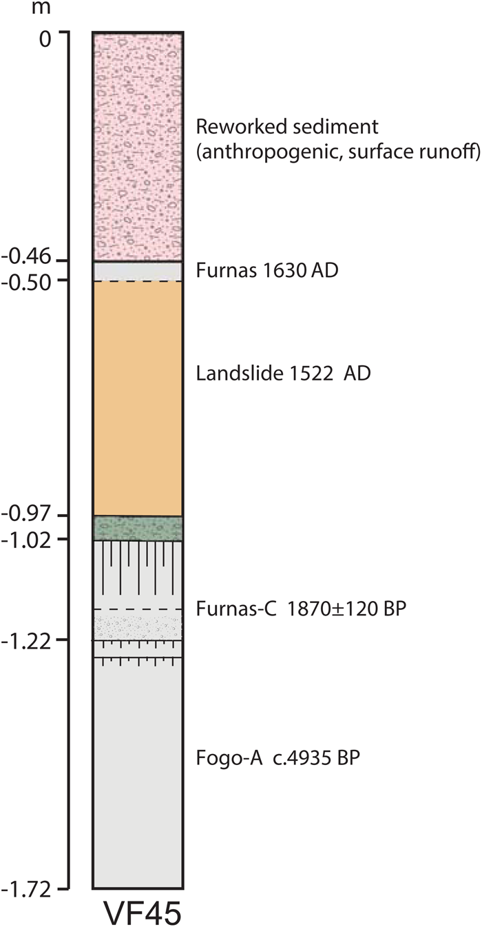
More recently, Marques et al. (Reference Marques, Zêzere, Gaspar and Amaral2009) undertook the first detailed sedimentological study of the 1522 landslide, establishing its depositional process and estimating its volume. In Vila Franca, the landslide deposit was found to lie above an ashfall deposit from Furnas C (c. ad 100) and capped by a thin layer of remobilized (reworked) material overlain by the ad 1630 ashfall deposit from the Furnas volcano (see for instance the profile of borehole VF45 on Figure 2). Without this research, there would have been no solid basis for further archaeological investigation.
Stratigraphic profile from borehole VF45 of the geological context for the 1522 landslide. (Redrawn by Melanie Froude and Alejandra Gutiérrez from Marques et al., Reference Marques, Zêzere, Gaspar and Amaral2009).
Fieldwork in 2015–2016
In 2015 and 2016, the EU-funded ArMedEa project (Archaeology of Medieval Earthquakes in Europe; Forlin et al., Reference Forlin, Gerrard and Petley2015) undertook test excavations at twenty-six locations across Vila Franca (Figure 3). Two sections, one at the centre of the landslide (Trench 4) and a second at its margin (Hillside Exposure 27), were sampled and recorded, including measurements of clast fabric, grain size, and unit thickness (online Supplementary Material 1). In Trench 4, a monolith sample column was extracted, from which two micromorphology samples were removed for further study (Supplementary Material 2). To recover charred plant remains, charcoal, small bones, and finds, bulk soil samples were taken from Trenches 18, 22, 25, and 26. Although only a tiny fraction of the landslide area was sampled where access was permitted, the main weakness of machine trenching (a relatively poor rate of finds recovery) was balanced by sieving key contexts in the test pits through a 1-cm mesh.
Above: location of excavation trenches and borehole investigations by Marques et al., Reference Marques, Zêzere, Gaspar and Amaral2009, indicating landslide presence or absence. Below: detail of the town plan locating places mentioned in the text and borehole VF45 (Figure 2).
Figure by Melanie Froude and Alejandra Gutiérrez. Elevation contours calculated from the ALOS, 2018 digital elevation model.

Vila Franca Do Campo Before 22 October 1522
A key topographic feature of Vila Franca today is the Ribeira da Mãe de Água, a steeply incised channel which runs down to the sea (Figure 3). Frutuoso's description implies that most of the inhabitants lived to the east of this stream, two important landmarks in the pre-disaster townscape being the main church of São Miguel Arcanjo, established in 1460—the items recovered in 1991 during construction of the Municipal Centre being plausibly from there—and the Franciscan friary at Terras do Engenho, located by Oliveira to the north of the town (Oliveira, Reference Oliveira2016; Figure 3). Frutuoso also mentions bridges across the Ribeira, together with ‘noble’ and ‘tall’ houses. The historic building stock on the island suggests that these were single-storey or two/three-storey houses with load-bearing irregular ‘rubble’ stone masonry walls of basaltic and other volcanic rocks, a half-basement, wooden beams, planked floors, and a roof with closed trusses, some clad with ceramic tiles. Frutuoso provides an account of three survivors, trapped beneath the landslide, probably in a basement, who sheltered for nine days beneath fallen house beams. Among the finds from our excavations were roofing tiles and substantial architectural fragments (e.g. from context 22006; Figure 4).
Above: Trench 22 section. Note that the thickness of the landslide is truncated here. Below: the section recorded by photogrammetry. The dressed ashlar stone probably framed a window or door, though better-quality buildings may have been faced.
Figure by Alejandra Gutiérrez. Photogrammetry by Paolo Forlin.

Pre-1522 surfaces were recorded in only five trenches (17, 18, 22, 25, and 26) where sixteenth-century ceramics from Portugal and Spain were recovered. Among these were sherds of nine different Valencian lustreware vessels, which can be closely dated between 1450/80 and 1500/30 (Gutiérrez, Reference Gutiérrez2000: 38–39). The best-preserved context was in Trench 22, where the landslide had sealed two superimposed floors (22009, 22011) and their interleaving occupation layers (22010, 22012; Figure 4). Most pre-1522 finds were not found in situ and so cannot be linked to specific households or buildings, but they do show that non-perishable goods were being shipped from the European mainland in quantity. By contrast, environmental analysis underlines the wide range of wild and newly introduced domestic animals and crops which were available to the islanders. These will be discussed in a separate article.
Beneath these occupation layers, micromorphological analysis in Trench 4 identified the lowermost part of the pre-1522 topsoil (the upper part being truncated) as a medium-brown silt-loam (Figure 5; Supplementary Material 2). This contained minute organic fragments, plant phytoliths, and minute fragments of charred wood and seeds. In Trenches 18 and 22, this silt-loam overlay an orange-brown ashy soil (at a depth of 3.10 m from the ground surface in Trench 22) on top of natural pumice and ashfall, assumed to derive from the Furnas C eruption of c. ad 100. At the shoreline, basalt bedrock was recorded directly beneath this pumice in Trench 24. In the adjacent Trench 25, Furnas C pumice had been reworked and interleaved with volcanic beach sands, probably by storm events that pre-dated 1522 (Figure 6).
Trench 4 under excavation with stratigraphy showing micromorphology block (see Supplementary Material 2) extracted at the interface between the 1522 landslide and underlying soils.
Figure by Melanie Froude and Alejandra Gutiérrez. Photograph reproduced by permission of Paolo Forlin.

Trench 25 section showing the ‘toe’ of the landslide and (inset) the adjacent topography and its interpretation. Figure by Alejandra Gutiérrez.

The Earthquake
According to Frutuoso, in the early morning of 22 October 1522 everyone was asleep when a ‘great and terrible earthquake’ struck at about 2 a.m. (Frutuoso, Reference Frutuoso1998: Chapter 70). The first tremor lasted the combined duration of the recital of ‘a Creed, Paternoster and a Hail Mary’, more than one minute, and caused severe structural damage across Vila Franca. The main church of São Miguel Arcanjo collapsed and, as Oliveira discovered, the Franciscan friary was destroyed (for locations, see Figure 3). Of the named buildings, only the chapel of Santa Catarina, constructed at the end of the fifteenth century, remained standing. Later on 22 October, four large aftershocks were felt at 2.10 a.m., 3 a.m., 12 p.m. and 6 p.m., the 3 a.m. event being the most intense.
The earthquake generated distinctive structural deposits. In Trench 26, semi-articulated stone rubble with attached and disaggregated mortar (context 26017) was identified as fallen and displaced walls. In Trench 22, a compacted occupation surface (context 22011), 30–40 mm thick, was cracked and vertically displaced by 20 mm (Figure 4). Destruction layers aside, however, it is the artefact assemblage that stands out. In all, eleven pre-1522 coins were recovered from horizontal landslide-sealed layers in Trenches 18 and 26. In Trench 18, three coins (one of 1433–1438, two dated 1438–1481), a short distance apart, may indicate a purse rather than single coin losses. More fragile items were also found, including twelve copper-alloy lace tags (all in pre-1522 deposits), forty-two dress pins (of which thirty-nine were from pre-1522 deposits), and glass vessel fragments.
While the eastern and western margins of the island were subjected to severe shaking (Intensity VIII), the centre of São Miguel suffered most (Silveira et al., Reference Silveira, Gaspar, Ferreira and Queiroz2003). Settlements at Ponta Garça, Maia, and Porto Formoso were all badly affected (see Figure 1 for locations) and a commemorative plaque in the village of Água de Pau records the collapse of the church there (founded pre-1488, re-built from 1525); architectural fragments rescued from the debris are displayed today on the exterior façade.
The Landslide
Frutuoso recounts how the earthquake ‘broke away a great part of a hill at the foot of the mountain, which is above the town […] it swept everything before it, like thunder’. This is a clear description of a high-mobility landslide. When the landslide reached the waterline it ‘took possession of the sea and entered it’, generating a tsunami-type wave that damaged boats anchored about 700 m off the coast (Andrade et al., Reference Andrade, Borges and Freitas2006). Several survivors were swept into the water clinging to wooden planks and trees and even, in one case, a bed. One ‘very large boulder crossed the whole village from the hills to the sea […] where it came to rest in the old port […] entering the water for about forty paces’ (all quotations from Frutuoso, Reference Frutuoso1998: Chapter 70).
Marques et al. (Reference Marques, Zêzere, Gaspar and Amaral2009) identified a scar in the Ribeira da Mãe de Água river valley as one possible source of the landslide (Figure 3) and we can assume that the earthquake would have triggered multiple landslides there (Keefer, Reference Keefer1984). Frutuoso describes the land ‘running’ downslope in many places, indicating that simultaneous co-seismic slope failures coalesced in the Ribeira channel into a single flow. Inspection of the 5 m resolution digital terrain model (based on the 1:25000 scale topographic map by the Azores’ Topography, Design and Cartography Division of the Regional Service for Housing and Equipment, DTDC-SRHE) in conjunction with Google Earth imagery, shows a distinctive concave slope approximately 500 m in length with a semi-circular steep back scarp, which is likely to be a landslide scar. The composition of the landslide deposit is consistent with deposits of the Fogo A Plinian eruption (i.e. an eruption that generated columns of volcanic debris and hot gases) (Marques et al., Reference Marques, Zêzere, Gaspar and Amaral2009), which are estimated to be 5–10 m thick at this location (Walker & Croasdale, Reference Walker and Croasdale1971).
Marques et al. (Reference Marques, Zêzere, Gaspar and Amaral2009) calculated that the landslide volume (including the coincident flow at Ribeira Seca) was 6.75 × 10⁶ m3. This is consistent with Frutuoso's description of a landslide ‘flooding [the town] and covering it with earth, mud, and some large boulders from the northern side, completely sealing it’. The narrative suggests a ‘flow-type’ landslide concurrent with the earthquake, something which is commonly reported (Keefer, Reference Keefer1984, for example). The landslide scar lies on the edge of the Pleistocene Pico do Vento dome, formed from trachyte, an igneous rock extruded by the volcano. The crown (top) of the landslide is within a cinder cone (mapping by Carmo et al., Reference Carmo, Madeira, Ferreira, Queiroz, Hipólito, Gaspar, Guest, Duncan, Barriga and Chester2015). A unit of igneous rock, formed as a flow, runs parallel with the scar, and there are outflow deposits (i.e. pyroclastic flow, pumice fall), an active spring, and fault near its base. The southern flanks of the Fogo volcano have many springs fed by perched aquifers confined by impervious geological layers (such as ash fall; Cabral et al., Reference Cabral, Andrade, Coutinho and Cruz2015). These geological structures provide suitable conduits and storage for groundwater, which may have enhanced instability in the hillslope and transformed it into a low cohesion ‘debris flow’, as defined by Varnes (Reference Varnes, Schuster and Krizek1978).
Despite truncation or removal in some areas, we found evidence for the landslide in fourteen of our twenty-six trenches. Micromorphology from Trench 4 confirmed the deposit to be coarse and poorly sorted, with angular rhyolitic pitchstone gravel up to 2 cm in diameter embedded in a yellow-brown silt-loam (Supplementary Material 1 and 2). The overall fabric of the geomorphology sub-units (coded L2–L5 on Figure 5) was isotropic, indicating that clast orientation and dip were essentially random and consistent with a landslide deposit (see Supplementary Material 2). Some inhabitants were evidently outrun by the landslide, which implies that it must have been travelling at >2–3 m per second at that location; Frutuoso notes that ‘the earth ran like waves of the sea’, highlighting a pulse-like behaviour in which the deposit was laid down progressively, i.e. the sub-units L2–L5 represent subtle shifts in flow characteristic of a single event.
At the periphery of the debris fan in Hillside Exposure 27, the base of the landslide was scoured and mixed with the underlying Furnas C ash, indicating turbulence and pulses with higher water content. An erosional contact here is consistent with saturated flow, possibly involving liquefaction of the remobilized sediment. At its centre, on the other hand, the landslide deposit was thick with a consistent structure, vertically less heterogeneous with a near-horizontal erosional contact with the palaeosol. In Trench 4, this boundary was sharp but undulating (Supplementary Material 1 and 2; Figure 5) and the uppermost layer of vegetation, roots, and root channels had been scoured away. Gravel and pitchstone fragments of any size were completely absent from the original soil, but the uppermost 3 cm of sealed soil was perforated by numerous pitchstone gravel pieces from the landslide deposit, which had been pressed down into it when the surface was disturbed.
These physical characteristics have a crucial bearing on the interpretation of the archaeology. The horizontal erosional contact between the landslide and the palaeosol confirms that contexts pre-dating 1522 were sometimes removed by the landslide and transported downslope. There is no ‘intact’ settlement waiting to be discovered beneath the main body of the landslide, as previous scholars have asserted (e.g. Ferreira, Reference Ferreira1929).
Nevertheless, pre-1522 deposits do survive well in some areas, for example outside the main path of the landslide in Trench 18 where the debris flow was only 7 cm thick. As Frutuoso explains, some houses survived ‘because the land was tired and not so furious’, presumably where the landslide was running out of energy. More surprisingly, there are also islands of good preservation directly beneath the main body of the landslide. Contexts 26013 and 26016 in Trench 26 are best described as a ‘carpet’ of material including animal bones, fish bones and scales, charcoal, roof tiles, and nails, alongside quantities of vessel glass, dress accessories, and coins (Figure 7), and an overall density of pottery fragments in context 26016 in excess of 5500 sherds per m3 (Supplementary Material 3, Table S1). This trench alone produced 111 fragments of vessel glass (from a minimum of six different vessels), including thin vessel walls (1–2 mm thick) and thicker goblet stems. A single beaker in context 26016 had broken into twenty-two sherds, confirming that the fragments had not moved far. Conjoining sherds of the same pottery vessel, or sherd links, within and between several contexts, confirm that these sediments were laid down in quick succession (Figure 8). Although there were no intact vessels, the pottery sherds are large and unabraded, indicating little movement. These contexts may have been sheltered by partially standing buildings and fallen debris after the earthquake, perhaps by the nearby church of São Miguel Arcanjo.
Trench 26, destruction layer 26016 under excavation. Note the density of finds. Later interventions have cut the remaining stratigraphy. Photograph reproduced by permission of Paolo Forlin.

Trench 26, reconstructed section with sherd links between excavated contexts. Figure by Alejandra Gutiérrez.

Debris flows lay down material by thrusting forward and pushing aside previously deposited debris, such as the flattened wall seen in Trench 26, but also by progressive vertical accretion (Major, Reference Major1997). This ‘bulldozing’ effect of the first significant debris flow explains, firstly, the general paucity of archaeological artefacts within the landslide itself (Supplementary Material 3, Table S2) and, secondly, the changing character of the landslide deposit at its ‘toe’ where it reached the water's edge. In Figure 6, the waterfront deposits in Trench 25 are related to the main body of the landslide uphill to the north, and strongly suggests that an accumulation of cultural material was propelled downhill and on top of the bleached pumice (context 25019) where it shelved down into the sea. Contexts 25027, 25028, and 25030 in particular are more humic, semi-compacted with abundant charcoal, and generally darker and richer in colour, with a notable density of artefacts including eight pre-1522 coins and eighteen dress pins, as well as abundant fish and animal bones. These contexts form a coherent packet of banded and steeply inclined layers that accumulated towards the front of the landslide when it hit the water. Logically, it was here that treasure hunters found the easiest pickings. ‘At night’, says Frutuoso (Reference Frutuoso1998: Chapter 70), ‘many lanterns and lamps burned along the seashore from Vila Franca to Agua de Alto’. These were not the souls of those who had died or the ‘Faithful of God’ who walked there, as some believed, but beachcombers looking for objects washed out by the sea. Any finds of valuables or clothing were shared out between the rescuers, but looters were clearly a concern: valuable finds were ordered to be centrally deposited.
Relief Operations
The rescue work was coordinated by the lord-proprietor, Captain Rui Gonçalves da Câmara, whose family held the donation charter on the island. The rescuers, composed of relatives and acquaintances from all over the island, dug to remove the bodies: dogs ‘howled, feeling the men who cried under the earth’ (Frutuoso, Reference Frutuoso1998: Chapter 70). In all, the captain's diggings lasted more than a year. In several areas the landslide deposit was found to have been removed altogether (e.g. in Trenches 1, 2, 3, 5, and 6, although it was in situ in Trenches 4 and 7) and the volume of residual sixteenth-century material in contexts of a later date is striking, reaching fifteen per cent in Trench 22. This may be due in part to rescuers digging down through the landslide layers. Perhaps reflecting the thoroughness of the search, a single human tooth from Trench 25 is the only evidence of human remains found during excavation.
The high mortality rate at Vila Franca was caused in part by the delay between the earthquake and the arrival of the landslide. For Frutuoso ‘it seemed clear that with the tremor they fled from it [i.e. the earthquake] and the earth [i.e. the landslide] caught them while fleeing and engulfed them’. Many casualties were discovered fully clothed, suggesting that the earthquake must have awakened some inhabitants and given them time to dress. Then, as families began to make their way towards the church of São Miguel Arcanjo in the darkness, they unwittingly stepped straight into the path of the oncoming landslide. Others did not wake at all and were ‘taken by the earth that ran’. Given the remote island geography, no outside assistance was possible in the form of additional help, foodstuffs, or medical provisions: some victims could not be reached quickly enough by rescue teams.
Rehabilitation and Reconstruction
The immediate priority was the ecclesiastical infrastructure. Concerted efforts were made to recover the ‘Holy Host’, the consecrated bread and wine which represents the body and blood of Christ. This would have been kept in a tabernacle, a locked cabinet at the high altar of the fallen church of São Miguel Arcanjo. The sacrament was required for the administration of the last rites for the injured and dying, but spiritually the Holy Host was also the most important body trapped under the rubble, not least because of its association with the Resurrection of Christ (Forlin, Reference Forlin, Gerrard, Forlin and Brown2020). When it could not be found, some recalled seeing a great light and, hearing the sound of bells, believed that the sacrament had been removed to safety by angels, possibly to the nearby church of Água de Pau.
There was no rush to rebuild on the footprint of the landslide. Much of the area worst affected remained open land until the late eighteenth century, and even then, only single-storey housing was constructed (Harding Read, Reference Harding Read1806). Instead, the chapel of Nossa Senhora do Rosário was hastily erected at a safe distance to the west and, by royal decree, construction began on a new town as early as 1 February 1524. Encouraged by royal privileges and freedoms, by the 1580s there was already a thriving settlement there with 1931 souls for confession (Patricio, Reference Patrício2006; SIPA, 2012). The new parish church built between 1534 and 1561 possibly inherited its layout and building materials from the destroyed site of São Miguel Arcanjo, as well as its dedication (de Medeiros, Reference de Medeiros2000: 95). The massive new plinth foundation would have helped prevent lateral spread beneath the building and loss of bearing strength when the 1630 earthquake struck. Meanwhile, Nossa Senhora do Rosário had been converted into a Franciscan friary in 1525 (see Figure 3 for location) with financial aid from King João III ‘the Colonizer’, and the site of the former church of São Miguel Arcanjo was commemorated in 1533 by the construction of a new nunnery of the Order of St Clare, the Convento de Santo André. This duplication of the ecclesiastical infrastructure in the reconstructed urban area served as an effective reminder of the pre-1522 townscape.
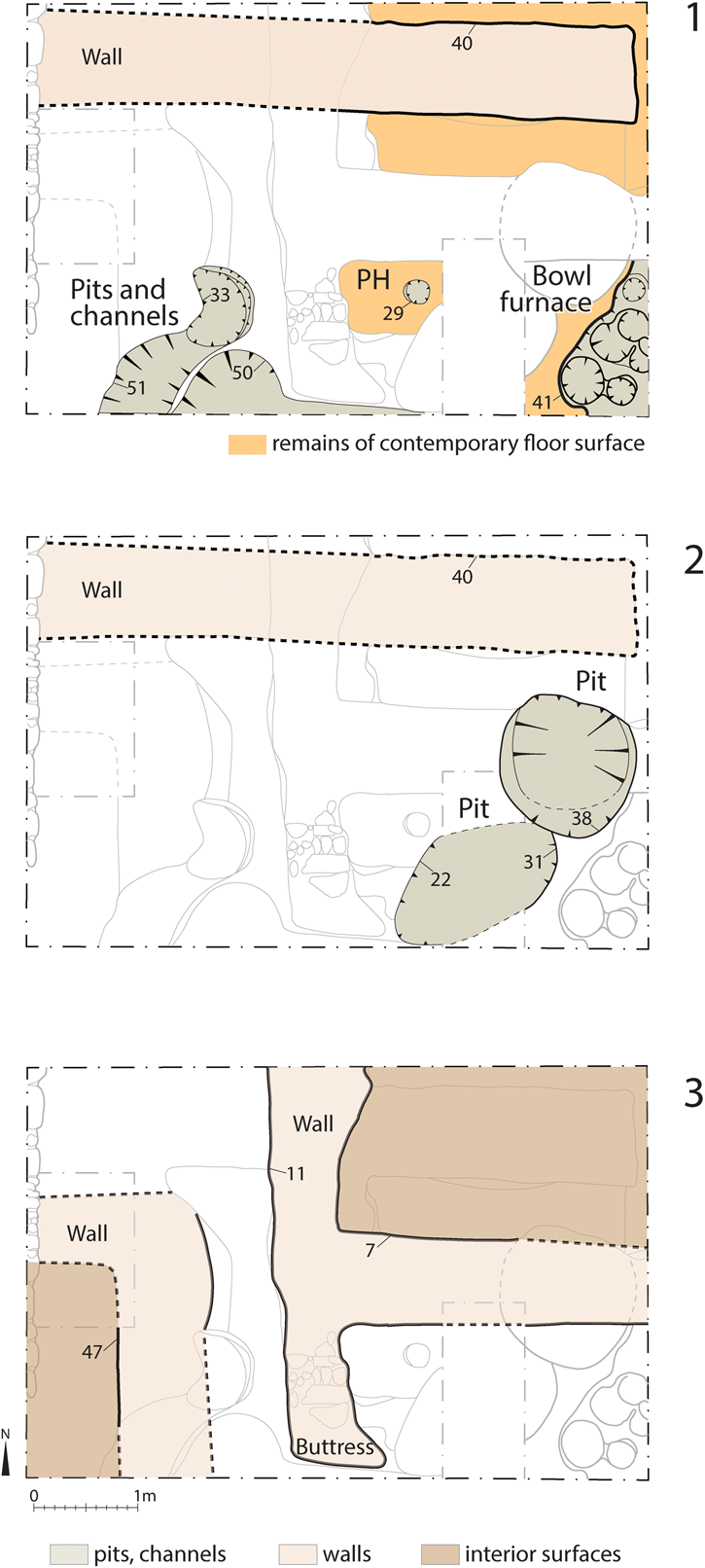
In Trench 18, part of a post-1522 blacksmith's workshop was identified, sufficiently remote from the heart of the new town so as not to constitute a fire hazard (Figure 9). Excavated features cut into the compacted surface of the landslide included a wall (context 18040), shallow pits or quenching troughs (18050 and 18051), postholes (18029) for a canopy and perhaps bellows, and the bowl of a smithying furnace (18041), which was filled with charcoal and hammerscale. Charcoal roundwood from the bowl furnace provided a radiocarbon date of 1525–1800 cal ad at 68.2% probability (SUERC 84652, 257 ± 34 bp) (whole range following Millard, Reference Millard2014). There was no evidence for smelting, and the workshop probably used imported iron bars (bloom) to make nails, horseshoes, and other standard products that would have been needed during the reconstruction process.
Trench 18. a) A partially preserved post-1522 smithy with bowl hearth and possible quenching troughs. The uppermost layer of the landslide was truncated to become the floor surface. b) The smithy area was later cut by two rubbish pits. c) Two buildings were then erected, one with a stone corner buttress. Figure by Alejandra Gutiérrez.
Discussion
Flat coastal land was attractive to settlement on a small colonial island where there was a premium on marine communication and trade. In October 1522, unconsolidated volcanic deposits, local topography, and the clustering of urban housing close to the Ribeira da Mãe de Água combined to leave the unwitting inhabitants of Vila Franca especially vulnerable and gave little warning when the earthquake struck, especially given the hour of the day. The clearance of trees and the cultivation of land around a town in the early stages of colonization may itself have promoted surface flow (Connor et al., Reference Connor, van Leeuwen, Rittenour, van der Knaap, Ammann, Björck and Fernández-Palacios2012; Rull et al., Reference Rull, Lara, Rubio-Inglés, Giralt, Gonçalves and Raposeiro2017). It was the combination of these factors which transformed a tectonic hazard into a disaster.
For Frutuoso (Reference Frutuoso1998: Chapter 70) the cause of the landslide was divine: ‘People lived in a wealthy style without morality’, and ‘this is why the wrath of God struck Vila Franca’, he writes. Religious belief certainly informed many aspects of the rescue operation, from the pursuit of the Holy Host to the persistent searching for the dead. This is also true of other seismically-affected sites (Forlin, Reference Forlin, Gerrard, Forlin and Brown2020). Later, when the buried townscape came to be replaced by a new town, the marking out of the ecclesiastical infrastructure within the post-1522 urban fabric again became a priority. By that time, post-disaster new towns were not, in themselves, a novel solution but it was clearly a priority to encourage permanent settlement here in the context of the Portuguese expansion in the Atlantic.
What efforts were made to learn from the 1522 experience? Again, religion framed the response. First, the new Convento de Santo André established an important landmark where the church of São Miguel Arcanjo had once stood. Second, although the new church of São Miguel Arcanjo may have incorporated salvaged materials from its predecessor, the church at neighbouring Água de Pau, with its commemorative plaque and display of worked stones from its ruined church, provided a visible reminder. Third, local collective memory was strengthened through litany and practice. At the newly constructed chapel of Nossa Senhora do Rosário, the local priest encouraged survivors to confess and ask God for mercy, pleading for the intercession of the Virgin Mary. Marian shrines, such as this one, were often the subject of devotion following natural disasters, especially after earthquakes (Forlin & Gerrard, Reference Forlin and Gerrard2017). Thereafter, a procession of people would visit the hermitage of Santa Catarina (building that survived the earthquake) every Wednesday, the day of the earthquake, to recite Mass. At first a confraternity of local people established in memory of the event also visited the chapel every Wednesday at night or at dawn, but by the 1580s a commemorative Mass was held every year on 22 October throughout the island.
Although an eighteenth-century building uncovered in Trench 18 was found to be reinforced with a stone buttress (Figure 9c) and the new church was structurally underpinned by a plinth, the 1522 disaster did not generally inspire more seismically-resistant building techniques such as iron ties or timber cages (D'Antonio, Reference D'Antonio2013: 91–172). Nevertheless, no housing was constructed on top of the landslide for the next 300–350 years and the area worst affected remained outside the new urban area. This, at least, is a tacit acknowledgement of the risk of reoccurrence; at first the landslide deposit was probably still active, and every time it rained there may have been localized flooding and sediment-laden flows.
Overall, the immediate response to the events of October 1522 speaks of social connectivity and positive cultural interaction. Rescue attempts were neither poorly resourced nor out of step with reactions to disasters on the European mainland, which were similarly constrained. Although the Azores were geographically isolated, the people who lived there were well travelled and securely linked economically with a wider world, as the objects in their homes testify. Perhaps a sense of cultural identity and self was engendered by their island location. Only in the nineteenth century did dense urbanization encroach on the landslide deposit, exposing it once again to seismic activity.
The Azores continue to be subject to significant seismic hazard: for example, Carvalho et al. (Reference Carvalho, Sousa, Oliveira, Campos Costa, Nunes and Forjaz2001) estimated that the seismic hazard (with a ten per cent probability of exceedance in fifty years) for the Vila Franca do Campo area has a peak ground acceleration of 225–250 cm per second, which is a significant level of hazard. A repeat of the 1522 earthquake today would still cause substantial structural damage and trigger numerous landslides, something that is not always fully recognized (Martins et al., Reference Martins, Cabral and Sousa e Silva2012). Table 1 provides data on the ten earthquakes with the highest known number of landslide fatalities, prior to this study (Nowicki Jessee et al., Reference Nowicki Jessee, Hamburger, Allstadt, Wald, Robeson and Tanyas2018). The 1522 Vila Franca do Campo earthquake and landslide should now appear in this list and would be the oldest recorded event there. That two events in this list have occurred since 2000 demonstrates that vulnerability to seismically-induced landslides remains high.
The ten earthquakes with the highest number of known co-seismic landslide fatalities (based on data in. Mw: moment magnitude (Compiled by Dave Petley from data from Nowicki Jessee et al., Reference Nowicki Jessee, Hamburger, Allstadt, Wald, Robeson and Tanyas2018).

The location of the modern town at the foot of steep slopes and in the vicinity of channels with a known history of large landslides renders it vulnerable to a repeat of the 1522 event. The town has no meaningful defence. Such is the power of large seismically-induced landslides that modern buildings offer little more protection than did the buildings of 1522, though they are more resistant to earthquake shaking. Levels of destruction would be high and survival rates for those buried in landslides are low unless the victim is protected by a structure with a void beneath, such as a partially collapsed house. Fortunately, rescue and recovery operations are now more effective—although they can be chaotic in the immediate aftermath of a large earthquake—and injured victims have a far higher chance of survival. While the fatality rate from a repeat of the 1522 co-seismic landslide would be lower, it would probably be substantial.
Perhaps surprisingly, the literature on the impact of large landslides on the fabric of urban areas is limited. This has hindered recovery and rescue operations as it has proven difficult to know where to search for victims engulfed in a landslide. This is the first case in which a large urban landslide has been studied using multi-disciplinary techniques and it provides a useful contribution, demonstrating that, for a high-mobility landslide, unshielded structures and their contents tend to be bulldozed by the landslide and transported to the toe or, in some cases, the lateral margins of the slide. Where a structure is shielded by a larger building or the topography, victims and structures are often buried in situ.
Conclusion
The archaeology of the Vila Franca earthquake and landslide in 1522 presents unusual interpretative challenges. Although the prospect of extensive, sealed deposits proved illusory and the body of the landslide itself contained unexpectedly little cultural material, a great range and density of objects were recovered where suitable contexts had survived—a signature feature of the archaeology of rapid-onset disasters. Of particular methodological interest was the large quantity of material incorporated into the ‘toe’ of the landslide, where cultural layers had been pushed downslope. These near in situ assemblages are arguably more representative of daily life than more typical archaeological contexts in which artefacts and ecofacts have been selectively discarded in middens and pits. They represent ‘a moment in time’ and offer invaluable clues to life at an early date in the economic and social development of the islands.
At first glance, the obvious comparison for the case study presented here might be the Great Lisbon earthquake and tsunami of 1755. That event sparked vehement debate about the divine character of destructive ‘natural’ phenomena, beliefs which had themselves been formative to the response in Vila Franca 200 years earlier. There is an important difference, however. In Vila Franca, the greatest hazard that October night was the landslide not the earthquake tremors themselves; and, here, we hope to have provided new insight into how similar disasters in the future might affect buildings, and where victims might be recovered. Secondary hazards, especially landslides, are hugely neglected in the consideration of future earthquake events, despite the high toll that they frequently inflict.
Supplementary Material
To view supplementary material for this article, please visit https://doi.org/10.1017/eaa.2021.4.
Acknowledgements
This work was supported by a Marie Curie Intra European Fellowship (PIEF-GA-2013-626659) within the 7th European Community Framework Programme and by the Department of Archaeology, University of Durham. Special thanks to colleagues at the universities of Nova de Lisboa and dos Açores for their help with the fieldwork in Vila Franca, especially André Teixeira, José Bettencourt, and Peter Brown, as well as the Durham and Centro de História d'Aquém e d'Além-Mar (CHAM) teams who worked with us in 2015 and 2016. We are very grateful to the town council of Vila Franca do Campo and the local people for kindly supporting our research, especially mayor Ricardo Rodrigues and Telma Joana Silva at Vila Franca Municipal Museum. Thanks are also due to Dr Andrew Millard for advice on the radiocarbon dates and Dr Kamal Badreshany for analysis of the iron-working residues.


 Open access