





Impact Statement
Extreme storm surges and associated flooding can have devastating effects on coastal communities and ecosystems. Anticipating such events and preparing for them are essential for avoiding catastrophic impacts and loss of lives. Numerical models constitute a key tool in helping to forecast the occurrence of extreme surges, understand their evolution, assess their potential impacts and support recovery efforts. However, co-ordinated and systematic approaches for utilising the potential of these models do not generally exist, even in places where the capacity to operationalise the use of such tools exists. Following the extreme surge that occurred in the German Baltic Sea in October 2023, we propose a framework that can be used to maximise the potential of numerical models and the information they can produce for managing extreme coastal flooding in the region. We identify three phases (before, during and after the event) and suggest specific actions that need to be undertaken in each phase. These actions range from storing, documenting and analysing model results for a range of scenarios; to early warning, data collection and evaluation of recovery needs. Although the proposed framework is based on knowledge that already exists in the German Baltic region and assumes the use of technology and data that are only available in few places in the world, we expect that its general concept and specific elements can be implemented more widely; while rapid advances in technology and data collection will, in time, enable its application in a broader range of locations.
Introduction
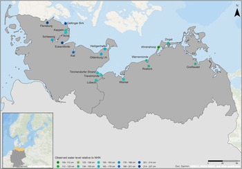
On 20 and 21 October 2023, a storm surge hit the western Baltic Sea, mainly impacting the German and Danish coastal areas. The storm led to very high coastal water levels at several locations along the German Baltic Sea (Figure 1), with certain areas experiencing extreme coastal water levels (ECWLs) with return periods potentially in the order of 200 years (Kiesel et al., Reference Kiesel, Wolff and Lorenz2024). Despite preliminary damage estimates being in the order of €200 million in the federal state of Schleswig-Holstein alone (NDR, 2023; Tagesschau, Reference Tagesschau2023) and isolated instances of protection failure (e.g. dike breaches), which led to significant damages in specific locations (e.g. Arnis, see Figure 1), German coastal communities were largely protected and prepared for an event of this extent and magnitude, thus avoiding catastrophic financial losses and loss of lives. Early warning, in the form of real-time ECWL forecasts, and a high level of preparedness at household level (e.g. use of sandbags and mobile barriers), combined with existing coastal protection measures (i.e. dikes), were instrumental in limiting the impacts of this storm surge.
Map of the German Baltic Sea coast, including characteristic locations that were affected by the October storm surge and information on maximum coastal water levels (based on Kiesel et al., Reference Kiesel, Wolff and Lorenz2024) that were recorded during the event.

Simulations based on numerical modelling have provided essential information and important insights for preparing against ECWL. This information includes, for example, the forecasting of ECWL at specific locations (e.g. Kiesel et al., Reference Kiesel, Honsel, Lorenz, Graewe and Vafeidis2023a), the definition of coastal protection standards (MELUND, 2022) and the assessment of potential impacts (e.g. Kupfer et al., Reference Kupfer, MacPherson, Hinkel, Arns and Vafeidis2024). Nevertheless, the occurrence of the event on 20 October and its aftermath demonstrated that the full potential of such models and associated analyses has not yet been attained and that there is considerable scope in further utilising and advancing numerical modelling to prepare for ECWL and manage their impacts. Based on previous and ongoing work in the region, we discuss a number of specific issues related to the modelling of such events and propose an operational scheme that can combine available knowledge, tools and instruments to support coastal flood-risk management. The proposed scheme includes three discrete but interlinked stages (pre-event, during the event, post-event) that correspond to a chain of actions which can (i) improve the preparation for the occurrence of ECWL and help mitigate damages and loss of lives; (ii) provide near real-time support for emergency services and responses; and (iii) support damage assessments and the fair and quick distribution of compensation aid. For these three stages, we assess existing capabilities and highlight priorities for their implementation.
Pre-event
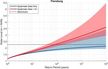
Systematic recording of sea-level measurements at tide gauges along the German Baltic Sea region has provided relatively long time series of water-level data (around 60 years, Wolski and Wiśniewski, Reference Wolski and Wiśniewski2021) that are essential for understanding the frequency and magnitude of storm surges, quantifying coastal flood risk and for planning effective coastal protection strategies to ECWL. However, sea-level observations are limited both spatially and temporally, and a range of statistical and numerical techniques have been developed to overcome these limitations. ECWLs are often defined by their return period, which describes the average amount of time between events of equal or greater magnitude and is used as the basis for the design of coastal protection structures. Along the German Baltic Sea coast, flood defences are designed based on an estimated ECWL with a return period of up to 200 years (HW200) and an additional height increase of 50 cm (constant value) to account for wave overtopping and sea-level rise (MELUND, 2022). Given that the longest high-resolution tide gauge record in the region extends for only about 75 years, the record length is short for estimating the return period of high-end events and estimates of HW200 can be highly uncertain. Recent work by MacPherson et al. (Reference MacPherson, Arns, Fischer, Méndez and Jensen2023) suggests that the current tide gauge network along the German Baltic Sea coast is not sufficient for estimating HW200 alone and that by including historical information on ECWL recorded before the installation of tide gauges, estimates can be vastly improved. For example, the inclusion of such information substantially reduces the uncertainty of the estimated ECWL (Figure 2) at Travemünde (see Figure 1) where there is an absolute reduction of approximately 50% (1.14–0.55 m).
Estimates of ECWL at Flensburg based on tide gauge data only (blue) and tide gauge data with historical information (H.I., in red) based on MacPherson et al. (Reference MacPherson, Arns, Fischer, Méndez and Jensen2023). Solid lines show the maximum likelihood estimates with uncertainties shown as shaded areas (95% significance intervals). The height of the October 2023 event is shown as a dashed black line.

In those cases where limited or no sea-level information is available, hydrodynamic numerical modelling can provide useful data for the estimation of ECWL. Previous studies have extended the available tide gauge data along the German Baltic Sea coast, both temporally and spatially, using hindcast simulations (Lorenz and Gräwe, Reference Lorenz and Gräwe2023). Validated against observations, these models provide long records of sea levels, even at ungauged sites (Kiesel et al., Reference Kiesel, Lorenz, König, Gräwe and Vafeidis2023b), and can be used for the estimation of return water levels. This is particularly useful when considering the large spatial variation of the experienced ECWL along the German Baltic coast during the recent storm surge. Other methods, such as spatiotemporal probabilistic modelling of surges, have also recently been used to provide probabilistic reanalyses of surge extremes and estimates of event probabilities at ungauged locations with high accuracy (Calafat and Marcos, Reference Calafat and Marcos2020).
The estimated return water levels constitute the basis for risk assessments, where, typically, a stylised hydrograph or a hydrograph of a past event is used as input into a hydrodynamic model to simulate flooding and associated risk (e.g. Wadey et al., Reference Wadey, Cope, Nicholls, McHugh, Grewcock and Mason2015). Due to the high computational requirements of numerical models and the lack of data, these studies have often focussed on only one or few events and typically only on the peak water level of ECWL. However, various studies (Hoeffken et al., Reference Hoeffken, Vafeidis, MacPherson and Dangendorf2020; Kupfer et al., Reference Kupfer, MacPherson, Hinkel, Arns and Vafeidis2024; Santamaria-Aguilar et al., Reference Santamaria-Aguilar, Arns and Vafeidis2017) have shown that the temporal evolution of the event can have a significant effect on flooding characteristics, with flood extent varying up to 60% for different intensities. Techniques to model the possible temporal evolution of storm surges (see MacPherson et al. Reference MacPherson, Arns, Dangendorf, Vafeidis and Jensen2019) and advances in computing, which allow for large numbers of hydrodynamic simulations to be conducted in short time, have enabled comprehensive assessments of flood risk at local scale, where a wide range of ECWL parameters can be tested. For example, Kupfer et al. (Reference Kupfer, MacPherson, Hinkel, Arns and Vafeidis2024) explore the sensitivity of flooding at Lübeck in Germany, producing probabilistic flood maps based on flooding from a large set of physically plausible synthetic hydrographs and/or ECWL of different return periods. Digital libraries of such maps are essential for providing a better understanding of the characteristics and uncertainties related to the temporal and spatial evolution of flooding, can account for many different hazard scenarios and are useful for evaluating and planning potential responses to specific types of events. In addition, various adaptation responses or scenarios can be integrated into the model setup in order to explore their effectiveness. This includes hard protection but also increasingly discussed and implemented nature-based solutions, such as the restoration of coastal vegetation via managed realignment (Kiesel et al., Reference Kiesel, Honsel, Lorenz, Graewe and Vafeidis2023a). In combination with sea-level rise scenarios, scenarios of failure of existing defences and the consideration of compound flood events (Kumbier et al., Reference Kumbier, Carvalho, Vafeidis and Woodroffe2018), this information can provide significant insights in decision analysis for developing optimal future adaptation strategies (van der Pol et al., Reference van der Pol, Hinkel, Merkens, MacPherson, Vafeidis, Arns and Dangendorf2021; Völz and Hinkel, Reference Völz and Hinkel2023) and efficient emergency planning.
During the course of an event
During the October 2023 surge, the German Federal Maritime and Hydrographic Agency (BSH) was providing real-time information on the temporal evolution of water levels at specific tide-gauge locations of the German coast, along with modelled short-term forecasts regarding the possible future development of water levels. Despite underestimating the surge by some 10–20 cm in some locations and occasional deviations when forecasting the temporal evolution of the surge (BSH, 2023) at the tide-gauge locations, the real-time forecasts were very useful for keeping the authorities and the public informed and for maintaining alertness during the event. This type of information can be further utilised as input for near real-time flood modelling, using models that have already been setup, calibrated and validated for specific locations, in order to provide timely information on the spatial development of the flood on land. In addition to a digital library of simulated flood maps that can be available before a surge, such information can be crucial for guiding emergency responses and evacuations but also for supporting the public in actions related to household-level adaptation. As Longenecker et al. (Reference Longenecker, Graeden, Kluskiewicz, Zuzak, Rozelle and Aziz2020) emphasise, flood-risk planning and emergency response at community levels rely on fast access to accurate inundation models that identify geographic areas, assets and populations that can be flooded.
Finally, an important element for refining and evaluating the models and the results is the collection of field data during the actual flood events. On-site measurements of flood characteristics (current flow velocity, flood depth and extent; e.g. Spencer et al., Reference Spencer, Brooks and Möller2014) or analysis of potentially available aerial (e.g. drones) or even satellite data obtained during the course of an event are important for model fine-tuning and validation. Field data are very rare as they are generally difficult to collect during an event, and the possibility of acquiring them with other methods is limited. For example, the Copernicus rapid mapping emergency service was activated for the October surge event but was unable to provide much relevant information due to cloud cover (https://rapidmapping.emergency.copernicus.eu/EMSR701/download, accessed 21 March 2024). However, near real-time data on flood characteristics are essential for model calibration and validation (Molinari et al., Reference Molinari, De Bruijn, Castillo-Rodríguez, Aronica and Bouwer2019) and for improving our general understanding of coastal flooding processes. To this end, instrumentation (e.g., pressure sensors) for collecting such data during a flood is generally available and affordable and networks of low-cost sensors can be established in flood-prone high-risk areas to automatically record and monitor, in real time, flood characteristics. Such information would also enable the use of data assimilation techniques for further improving flood modelling and the estimation of flood characteristics (Alvarez-Cuesta et al., Reference Alvarez-Cuesta, Toimil and Losada2024). Promising low-cost alternatives for data collection include harnessing the potential of citizen science and leveraging information from social media to obtain data on flood events (Eilander et al., Reference Eilander, Trambauer, Wagemaker and van Loenen2016; Pollard et al., Reference Pollard, Spencer and Jude2018). In this context, local residents can record water marks, measure water depth and collect geotagged photos of flooded areas (see e.g. https://mycoast.org/nj/high-water), while automated analysis of social media posts could provide high volumes of useful data at high spatial and temporal resolution (de Bruijn et al., Reference de Bruijn, de Moel, Jongman, Wagemaker and Aerts2017).
Post-event analysis
Following the storm surge, model simulations of the actual event, together with measurements acquired during the event, can in short time provide accurate mapping of flood extent and depth. Combined with detailed spatial data on assets and infrastructure exposure and associated vulnerability information, as well as post-event surveys, reliable preliminary assessments of damages can be conducted directly after the event in order to support rapid and effective restoration responses. Such methods are key to increasing the usefulness of early warning and can contribute to the mitigation of impacts (Dottori et al., Reference Dottori, Kalas, Salamon, Bianchi, Alfieri and Feyen2017). Further, these first-order estimates of damages can be used for the fair and timely allocation of resources/funds for compensation aid, a process which can be lengthy in terms of time, does not always address those most at need and is often implemented in ways that do not promote a resilient recovery (Slavíková et al., Reference Slavíková, Hartmann and Thaler2021).
Concluding remarks: Towards real-time flood-risk assessments and beyond
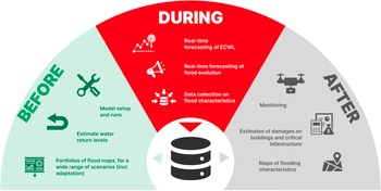
Advances in computing and data collection and the increased availability of elevation and assets data of high quality have in recent years introduced new possibilities and paved new pathways for supporting flood-risk assessment and management. With the use of hydrodynamic models at local scale, we are now in the position to produce comprehensive information on a wide spectrum of events of different magnitudes and can create digital portfolios of flood maps and associated risks for a wide range of plausible events and scenarios. At the same time, we can explore a range of adaptation measures, as computational capabilities allow us to conduct large numbers of simulations that are required for decision analysis. This also includes scenarios of future flooding under rising sea levels that are essential for understanding impending increases in flood risk that can be non-linear (Arns et al., Reference Arns, Wahl, Wolff, Vafeidis, Haigh, Woodworth, Niehueser and Jensen2020; Lorenz et al., Reference Lorenz, Arns and Gräwe2023) and for preparing for such events. This information should be complemented with data collected during events, which will help in fine-tuning and validating models, thus increasing confidence in their use. Near real time information on the evolution of the flood can complement early warning and can be instrumental in reducing damages and loss of life. How this information is communicated and managed is also a crucial element of this process; for example, failing to foresee potential defence failures can create a false sense of safety and lead to larger impacts (Haer et al., Reference Haer, Husby, Botzen and Aerts2020), whereas warnings on defence failures can result in panic reactions. All these elements can be integrated in an operational framework, which can support emergency planning and response (Figure 3). Further, in combination with data on exposure, such a framework can provide credible and transparent information for rapid assessments of impacts and can be used for streamlining financial and other support to those who have been impacted most.
Conceptual framework for integrating numerical modelling in coastal flood management.

Some aspects of the above are already used and implemented in several countries (e.g., the United States, the United Kingdom, the Netherlands and Germany) where flood management is an established component of environmental policy. Also, efforts in this direction have been initiated by organisations in the form of prototypes, a prominent example being the European Coastal Flood Awareness System (Irazoqui Apecechea et al., Reference Irazoqui Apecechea, Melet and Armaroli2023). However, even in those cases where models are extensively employed to provide related information, they are not specifically designed for emergency response operations and emergency managers are left with little information on the spatial characteristics of the flood (Longenecker et al., Reference Longenecker, Graeden, Kluskiewicz, Zuzak, Rozelle and Aziz2020).
It is also important to consider that, in order to produce the necessary information, such modelling frameworks require infrastructure that combines access to high-quality spatial data, computing infrastructure and expertise. Although very few countries in the world have access to such infrastructure, global geospatial data and high computing power are becoming increasingly available and affordable, while technology is enabling rapid knowledge transfer. At the same time, reduced-complexity models (Leijnse et al., Reference Leijnse, van Ormondt, Nederhoff and van Dongeren2021; Wing et al., Reference Wing, Bates, Quinn, Savage, Uhe, Cooper, Collings, Addor, Lord, Hatchard, Hoch, Bates, Probyn, Himsworth, Rodríguez González, Brine, Wilkinson, Sampson, Smith, Neal and Haigh2024) that are becoming freely available; the use of non-physics-based models and model emulations; and machine-learning methods applied in flood mapping (Bentivoglio et al., Reference Bentivoglio, Isufi, Jonkman and Taormina2022) can substantially reduce computational requirements and costs (Najafi et al., Reference Najafi, Shrestha, Rakovec, Apel, Vorogushyn, Kumar, Thober, Merz and Samaniego2024). Complementing the use of these methods, the rapid development of internet platforms and mobile applications offers new tools for producing and acquiring new data and information online, even in data-poor regions. These trends will hopefully allow for such methods to be more widely adopted, potentially leading to the development of local digital twins (Li et al., Reference Li, Feng, Ran, Su, Liu, Huang, Shen, Xiao, Su, Yuan and Guo2023) for managing coastal floods more effectively in the near future. We must nevertheless emphasise that for most places in the world these developments are currently still far from the point where they can be realistically implemented and significant efforts and investments need to be undertaken towards this end.
Considering the unavoidable increase in coastal flood risk as a consequence of climate-induced sea-level rise, potential changes in storminess and rapid socioeconomic development in coastal regions, our ability to contain loss and damage can be greatly enhanced by effectively utilising flood models in improving preparedness, providing near real-time information and supporting the response of the authorities to flood events. Our scientific and technical capabilities allow us to utilise inundation models at an increasing pace in order to provide fast access to accurate, understandable and actionable knowledge for supporting flood risk planning and emergency response at community level and for better managing flood risk. Operationalising this process however still remains a challenge and will require concerted efforts from scientists, local communities and governments.
Open peer review
To view the open peer review materials for this article, please visit http://doi.org/10.1017/cft.2025.4.
Acknowledgements
The authors thank the Federal Ministry of Education and Research and German Research Foundation (DFG) for funding. The authors would also like to thank Mrs. Saskia Erken and Mrs. Maureen Tsakiris for designing Figures 1 and 3.
Financial support
ATV and JK were supported by the Federal Ministry of Education and Research through the “ECAS-Baltic project: Strategies of ecosystem-friendly coastal protection and ecosystem-supporting coastal adaptation for the German Baltic Sea Coast” (BMBF, funding code 03F0860H). ATV, SK and LM were supported by the German Research Foundation (DFG) under the SEASCAPE II project as part of the Special Priority Program (SPP) -1889 “Regional Sea Level Change and Society.”
Competing interest
The authors declare no competing interests.

 Open access


Comments
Dear Dr Spencer,
Please consider the enclosed manuscript entitled “From flood forecasts to rapid assessments of risk and impacts – establishing operational modelling frameworks for coastal flood management at the German Baltic Sea coast” for publication as a Perspective paper in Coastal Futures. Our manuscript discusses the October 2023 record storm surge that hit the German Baltic coast and how numerical models were used to forecast and prepare for the event. Based on recent work that we have carried out in the region, as well as on in-situ visits during the course of the event, we discuss the potential of numerical models in supporting coastal flood management; and propose specific steps and actions towards operational modelling frameworks.
We believe that our manuscript will be of interest to the coastal hazard community, including researchers, planners and decision makers, and are confident that Coastal Futures is an ideal outlet for our work.
Sincerely (also on behalf of the co-authors)
Athanasios Vafeidis